


Below is the uncorrected machine-read text of this chapter, intended to provide our own search engines and external engines with highly rich, chapter-representative searchable text of each book. Because it is UNCORRECTED material, please consider the following text as a useful but insufficient proxy for the authoritative book pages.
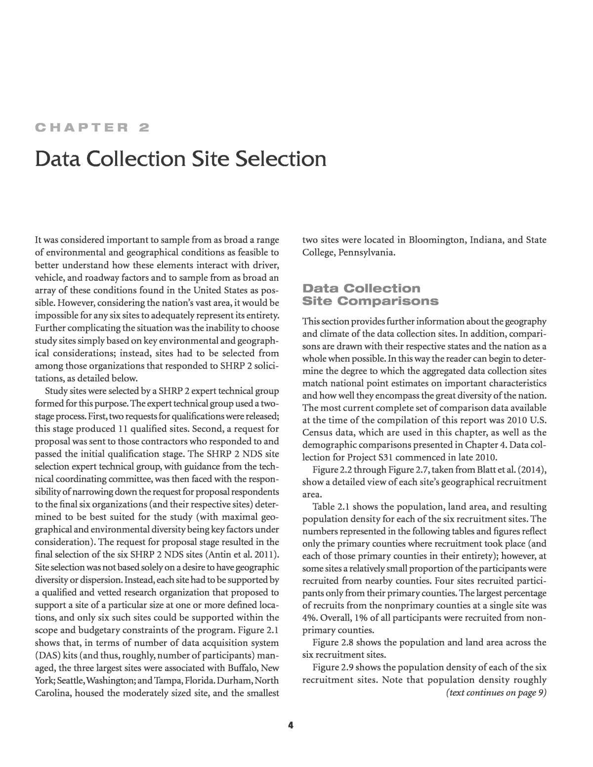
4C h a p t e R 2 It was considered important to sample from as broad a range of environmental and geographical conditions as feasible to better understand how these elements interact with driver, vehicle, and roadway factors and to sample from as broad an array of these conditions found in the United States as pos- sible. However, considering the nationâs vast area, it would be impossible for any six sites to adequately represent its entirety. Further complicating the situation was the inability to choose study sites simply based on key environmental and geograph- ical considerations; instead, sites had to be selected from among those organizations that responded to SHRP 2 solici- tations, as detailed below. Study sites were selected by a SHRP 2 expert technical group formed for this purpose. The expert technical group used a two- stage process. First, two requests for qualifications were released; this stage produced 11 qualified sites. Second, a request for proposal was sent to those contractors who responded to and passed the initial qualification stage. The SHRP 2 NDS site selection expert technical group, with guidance from the tech- nical coordinating committee, was then faced with the respon- sibility of narrowing down the request for proposal respondents to the final six organizations (and their respective sites) deter- mined to be best suited for the study (with maximal geo- graphical and environmental diversity being key factors under consideration). The request for proposal stage resulted in the final selection of the six SHRP 2 NDS sites (Antin et al. 2011). Site selection was not based solely on a desire to have geographic diversity or dispersion. Instead, each site had to be supported by a qualified and vetted research organization that proposed to support a site of a particular size at one or more defined loca- tions, and only six such sites could be supported within the scope and budgetary constraints of the program. Figure 2.1 shows that, in terms of number of data acquisition system (DAS) kits (and thus, roughly, number of participants) man- aged, the three largest sites were associated with Buffalo, New York; Seattle, Washington; and Tampa, Florida. Durham, North Carolina, housed the moderately sized site, and the smallest two sites were located in Bloomington, Indiana, and State College, Pennsylvania. Data Collection Site Comparisons This section provides further information about the geography and climate of the data collection sites. In addition, compari- sons are drawn with their respective states and the nation as a whole when possible. In this way the reader can begin to deter- mine the degree to which the aggregated data collection sites match national point estimates on important characteristics and how well they encompass the great diversity of the nation. The most current complete set of comparison data available at the time of the compilation of this report was 2010 U.S. Census data, which are used in this chapter, as well as the demographic comparisons presented in Chapter 4. Data col- lection for Project S31 commenced in late 2010. Figure 2.2 through Figure 2.7, taken from Blatt et al. (2014), show a detailed view of each siteâs geographical recruitment area. Table 2.1 shows the population, land area, and resulting population density for each of the six recruitment sites. The numbers represented in the following tables and figures reflect only the primary counties where recruitment took place (and each of those primary counties in their entirety); however, at some sites a relatively small proportion of the participants were recruited from nearby counties. Four sites recruited partici- pants only from their primary counties. The largest percentage of recruits from the nonprimary counties at a single site was 4%. Overall, 1% of all participants were recruited from non- primary counties. Figure 2.8 shows the population and land area across the six recruitment sites. Figure 2.9 shows the population density of each of the six recruitment sites. Note that population density roughly Data Collection Site Selection (text continues on page 9)
5 Figure 2.1. Six data collection sites and nominal distribution of the DAS kits. Source: Blatt et al. 2014. Figure 2.2. New York recruitment area and expanded view.
6Source: Blatt et al. 2014. Figure 2.3. Florida recruitment area and expanded view. Source: Blatt et al. 2014. Figure 2.4. Washington recruitment area and expanded view.
7 Source: Blatt et al. 2014. Figure 2.5. North Carolina recruitment area and expanded view. Source: Blatt et al. 2014. Figure 2.6. Indiana recruitment area and expanded view.
8Figure 2.7. Pennsylvania recruitment area and expanded view. Source: Blatt et al. 2014. Table 2.1. Population, Land Area, and Population Density of Six Recruitment Site Counties Location of Recruitment Site Counties Population Land Area (mi2) Population Density (persons/mi2) New York 919,040 1,042.69 881.41 Florida 1,693,923 1,767.10 958.59 Washington 3,439,809 5,872.35 585.76 North Carolina 1,368,273 2,201.35 621.56 Indiana 572,664 4,045.80 141.55 Pennsylvania 747,515 6,678.48 111.93 Source: U.S. Census Bureau 2010b. Source: U.S. Census Bureau 2010b. Figure 2.8. Population and land area across recruitment site counties.
9 corresponds to the number of DAS kits allocated to each site. Two of the three sites with the greatest number of kits, New York and Florida, were also the two highest in population density. The other large site, Washington, was just slightly less densely populated than the moderately sized North Carolina site. The two smallest sites in terms of DAS allocations, Indiana and Pennsylvania, were also by far the lowest in pop- ulation density. According to the 2010 U.S. Census Bureauâs listing of urbanized areas, all the primary cities within the areas from which SHRP 2 NDS participants were recruited are designated as urban (U.S. Census Bureau 2010a). Figures depicting comparisons between study recruitment areas, their respective states, and the nation as a whole include a series labeled âRecruitment Site Counties Weighted by Nomi- nal Site Size.â Data in these series are weighted based on each siteâs size, as determined by the number of DAS kits nominally allocated to that site as outlined in Figure 2.1 and calculated as in Appendix A. Figure 2.10 shows the population densities of the aggregated recruitment site counties, the aggregated SHRP 2 states, and the United States as a whole. The higher population density of the SHRP 2 recruitment sites, when considered as a weighted aggregate, exceeds both state and national concentrations. Figure 2.11 shows the data collection sites with their respec- tive latitudes, longitudes, and altitudes. Table 2.2 shows average January and July temperatures from 1981 through 2010 for each SHRP 2 state. Figure 2.12 shows average January and July temperatures for all recruitment sites, SHRP 2 states, and the nation from 1981 through 2010. The figure reflects that the recruitment site counties were slightly warmer in January than the SHRP 2 states as a whole, which were in turn slightly warmer than the U.S. average. In contrast, the average July temperatures for these three geographical groupings were nearly identical. Table 2.3 shows average annual rainfall in inches for the recruitment site counties from 1981 through 2010. Figure 2.13 shows average rainfall in inches across all recruit- ment site counties, SHRP 2 states, and the nation as a whole from 1981 through 2010. This figure demonstrates that rainfall amounts were similar for these three geographical groupings, with the recruitment sites and SHRP 2 states receiving some- what greater amounts of rainfall on average than the nation as a whole. 450 DAS 300 DAS 150 DAS Source: U.S. Census Bureau 2010b. Figure 2.9. Population density across recruitment site counties with nominal number of DAS kits managed at each site. (continued from page 4)
10 Source: U.S. Census Bureau 2010b. Figure 2.10. Population density. Source: The Weather Channel 2014; Google 2014. Figure 2.11. Site latitudes, longitudes, and altitudes (in feet above sea level).
11 Source: National Oceanic and Atmospheric Administration 2014. Figure 2.12. Average January and July temperatures ( î¸F), 1981â2010. Table 2.2. Average January and July Temperatures for Recruitment Site Counties, 1981â2010 Location of Recruitment Site Counties Average Temperature (î¸F) January July New York 24.85 71.10 Florida 60.20 82.50 Washington 41.72 64.50 North Carolina 40.34 78.64 Indiana 28.86 74.79 Pennsylvania 26.91 71.66 Source: National Oceanic and Atmospheric Administration 2014. Table 2.3. Average Annual Rainfall for Recruitment Site Counties, 1981â2010 Location of Recruitment Site Counties Average Annual Rainfall (in.) New York 40.48 Florida 49.46 Washington 38.85 North Carolina 46.27 Indiana 46.40 Pennsylvania 40.57 Source: National Oceanic and Atmospheric Administration 2014. Source: National Oceanic and Atmospheric Administration 2014. Figure 2.13. Average annual rainfall.
