


Below is the uncorrected machine-read text of this chapter, intended to provide our own search engines and external engines with highly rich, chapter-representative searchable text of each book. Because it is UNCORRECTED material, please consider the following text as a useful but insufficient proxy for the authoritative book pages.
7.0 Data Analysis 7.1 INTRODUCTION This section describes the supplemental data collected by the research team to create sample MOVES input datasets and illustrate the use of different types of data that may be available locally. Table 7.1 lists the MOVES inputs and corresponding data sources that were evaluated by the research team. The table also notes whether the effort was successful and any changes compared to the original proposed work approach. Some of the sample data were incorporated into the input-specific text and examples presented in the Practitionersâ Handbook. In addition, sample data files are provided in Excel files. Table 7.1 NCHRP 25-38 MOVES Input Data Analysis and Development MOVES Input Proposed Dataset and Analysis Outcome Temporal Adjustments Examine VTRIS data to develop examples of temporal distributions by source type and road type in different states. Spreadsheet prepared to permit queries by state; sample data shown. Temporal Adjustments Evaluate use of ITS, private vendor, and/or cell phone data for regional temporal adjustments by comparing with traffic recorder data for two or three sample areas. Completed with available data in Jacksonville and Atlanta metro areas and for State of Florida. Road Type Distribution and Ramp Fraction Evaluate available datasets (VTRIS, ITS) to compare source type-specific patterns with regional average patterns; provide sample source type-specific road type distributions from different contexts. Sources of road type distributions were limited and did not provide a good basis for making comparisons. Sample state-level source- specific distributions developed for states reporting in VTRIS. Off-Network Data Evaluate data from NHTS and two instrumented vehicle datasets to develop sample information on off-network activity. Used primary data from Port of Houston study and secondary data from a truck study in Pennsylvania and a parking study in Massachusetts to develop examples for three different types of off-network facilities. Evaluated NHTS data but determined not to be useful for this purpose. Link Source Types Develop sample source type distributions for different states and road types using VTRIS; evaluate and compare use of ITS data for this purpose from two or three sample regions. Developed state-level source type distributions using VTRIS data. ITS data not applicable. Average Speed Distribution (Regional, Link) Evaluate use of ITS, private instrumented vehicles data, GPS travel survey, and/or cell phone data for developing facility-specific or regional average speed distributions. Multiple sources, including ITS, GPS surveys, and private provider data were evaluated and compared with travel demand model and postprocessed speed estimates, using data from Atlanta and Jacksonville. 7-1
A summary of the data sources proposed for analysis and actually analyzed is provided below. Vehicle Travel Information System (VTRIS) â VTRIS consists of a network of permanent count locations on arterials and highways that can generally count, classify, and weigh trucks. These counters are typically part of the permanent count locations for the Highway Performance Monitoring System and the data are available through FHWA. The data include vehicle class, time, speed, functional classification of the roadway, and geometric information such as the number of lanes. VTRIS data reported to FHWA by 27 states for year 2012 were obtained and analyzed. Highway Statistics Series â Highway Statistics is an annual publication of FHWA that provides a variety of information on the condition and use of the nationâs highway system. Traffic volume data are provided based on data reported by states as part of the HPMS. Of interest to this research are tables providing estimates of VMT by state and roadway functional class, and by state and vehicle type. These tables can be combined to estimate road type distributions by source type at the state level. Intelligent Transportation Systems Data â These data include public agency roadway loop data, video, Bluetooth, or short-duration count data collected by state or metropolitan transportation agencies as part of their ITS systems. Data were obtained for the Atlanta and Jacksonville metropolitan areas from the respective state DOTs (Georgia and Florida).7 They were used to develop speed distributions and temporal distributions. The systems are only deployed on restricted access highways, so data from unrestricted access roads were not available from this source. Bluetooth Data â Data were evaluated from Bluetooth readers deployed on a limited basis in both the Atlanta and Jacksonville areas. In Jacksonville, the First Coast MPO provided data from a pilot deployment of BlueTOAD readers for a one-week period in May 2013. In Atlanta, Bluetooth data for 2012 were obtained for three arterials monitored by Cobb County. However, both of these datasets were deemed to have too small geographic coverage to develop regionally representative speed distributions. (The Jacksonville set included 29 stations, mostly in the downtown area and along I-95). There were also data quality issues with the Jacksonville data. As use of this data collection mechanism moves beyond the experimental stage, it could serve as another source for MOVES speed data. Private Vendor Speed Data â Aggregated travel speed monitoring data are available through private providers, typically obtained from anonymized 7 Atlanta and Jacksonville were selected because both cities had multiple data sources readily available to the project team. Also, Atlanta represents a large metropolitan area while Jacksonville represents a mid-size area. 7-2
readings from in-vehicle consumer GPS devices. Data were obtained from NAVTEQ for Atlanta (via the Atlanta Regional Commission) and from INRIX for Jacksonville. A major challenge of working with this data was matching the networks with regional travel demand volume networks, so that speeds by link could be appropriately weighted by traffic volumes. The level of effort required to complete this matching ultimately exceeded the project resources and the speed data were not fully analyzed. GPS Travel Surveys â In a number of U.S. cities, travel surveys have been conducted with a subset of the survey participants being instrumented with GPS devices to assist in tracking travel patterns. Data were obtained for Atlanta through the National Renewable Energy Laboratory Transportation Secure Data Center, which also processed the data to provide speeds by vehicle by link. These data were aggregated into speed distributions and compared these with other sources. Cell Phone Data with Location Information â Anonymous cell phone data, typically obtained through triangulation from cell towers, is increasingly being used for a variety of applications in transportation planning. The project team would have needed to purchase these data for specific areas and it is still somewhat experimental in nature. We concluded that they would not provide any better information than we could obtain from the NAVTEQ and INRIX private vendor sources, which we were able to obtain at a lower cost or for free. Travel Demand Forecasting Models â Data from the travel demand forecasting models maintained by the Atlanta and Jacksonville MPOs were used as a basis for comparing observed speeds and temporal distributions with other sources listed above. TDFMs are an important data source because they can provide forecasts of speed and volume data, in addition to coverage of existing roads that may not be covered by monitoring systems. However, the speed estimation routines in TDFMs are known to be far from perfect. Therefore, a variety of speed postprocessing methods were tested and the outcomes compared with observed speeds. Data Sets for Off-Network Activity â Instrumented truck data from a study at the Port of Houston were analyzed to develop sample off-network activity inputs for an intermodal terminal. Two other studies were identified â a truck stop study in Pennsylvania and a parking lot study in Massachusetts â that were used to provide examples of developing off-network inputs for these types of facilities. Supplemental Data on Commercial Vehicle Populations â Data sources were investigated that could be used to develop more detailed estimates of vehicle population, age distribution, and activity for different types of commercial vehicles. These included the Motor Carrier Management and Information System (MCMIS) maintained by the Federal Motor Carrier Administration (FMCSA), state motor carrier registration databases, and the International Registration Program (IRP). 7-3
Section 7.2 documents the data source and processing methods we applied for each source to obtain sample MOVES inputs. Section 7.3 compares sample data developed from these sources with each other and with embedded MOVES data. 7.2 DATA SOURCES Vehicle Travel Information System (VTRIS) A number of MOVES inputs describe VMT distributions and can be derived from traffic count stations that are maintained by state DOTs as part of Federal data collection requirements. These inputs include: ⢠VMT by HPMS vehicle class; ⢠Road type distributions â percent of VMT by road type; and ⢠Temporal adjustments â percent of VMT by hour, day of week, and month. The network of traffic counting stations often includes a subset of stations that record vehicle classification. States report VMT by vehicle class to FHWA as part of the Vehicle Travel Information System, and this information is available at a state level from either the state DOT or through FHWAâs Office of Highway Policy Information. In addition, although many MOVES users do not take advantage of this capability due to data limitations, temporal distributions can be provided for different vehicle types (including up to the 13 individual MOVES source types) and by road type for day and hour fractions. Table 7.2 shows the VMT-related MOVES inputs and disaggregation options. Table 7.2 VMT-Based MOVES Inputs Table Name Contents Provided by HPMSVTypeYear Total VMT âHPMSâ vehicle types (6) roadTypeVMTFraction Fraction of VMT by road type MOVES source types (13) monthVMTFraction Fraction of VMT by month MOVES source types (13) dayVMTFraction Fraction of VMT by day type (weekday, weekend) MOVES source types (13) x road types (5) hourVMTFraction Fraction of VMT by hour of day MOVES source types (13) x road types 5) x day types (2) Summary of VTRIS Data Findings States report their classified traffic count data to FHWA, much of which is stored as part of the VTRIS. As part of this research, VTRIS data reported for 2012 were investigated to determine the extent to which they could provide source type- specific temporal and road type distributions at the state level. Example data 7-4
tables were developed, along with an Excel query tool to allow the user to develop distributions for individual states that reported data to VTRIS. The research team determined that VTRIS data are suitable to develop temporal sample data tables for MOVES, such as hour and day fractions, at the state level. However, only one state (Maine) had sufficient data over the course of a year from which to develop month fractions, and only for rural roads. For geographic-specific data, the VTRIS data are not easily weighted to expand representatively by road types, and it appears preferable to make use of tables provided in Highway Statistics, as described in the next section. The VTRIS data source, despite its richness, has other limitations. The extent of the classification counter network varies by state, but the number of stations is usually too small to derive distributions specific to vehicle type at anything below a state level, including for individual counties. Also, the vehicle classifications correspond with the six âHPMSâ vehicle types and distributions for MOVES subclasses (e.g., short- versus long-haul trucks) must be assumed to be the same absent any better information. Only 27 states submitted data for VTRIS for 2012; the remainder are not included in this analysis, although it may be possible to obtain similar data directly from the state DOT. Alternatively, it may be possible for the MOVES user to âborrowâ data from other states where VMT patterns are believed to be similar to their own state. The VTRIS Dataset The complete VTRIS data were obtained for calendar year 2012. Also obtained, but not processed, were partial year data for 2013. VTRIS includes four data text files: Automatic Traffic Recorders (ATR), Classification Counts, Stations, and Weigh-in-Motion (WIM). The ATR data includes unclassified counts and therefore was not of interest for this analysis. The WIM data also were not of interest. The Classification Counts file contains counts by station. The Station text file provides various geographic, administrative, and functional information about the counting stations used in the ATR, classification, and WIM data collection. For this research, the raw text records from these files were imported into Microsoft Access for processing, using the data formatting information included in the FHWA Traffic Monitoring Guide, Chapter 7. In addition to obtaining the raw data in text file format, stations can be queried interactively on-line.8 An example of such an on-line report for Rural Interstates in Alabama during 2012, consisting of the average of records from 16 stations, is shown in Figure 7.1. 8 https://fhwaapps.fhwa.dot.gov/vtris-wp/. 7-5
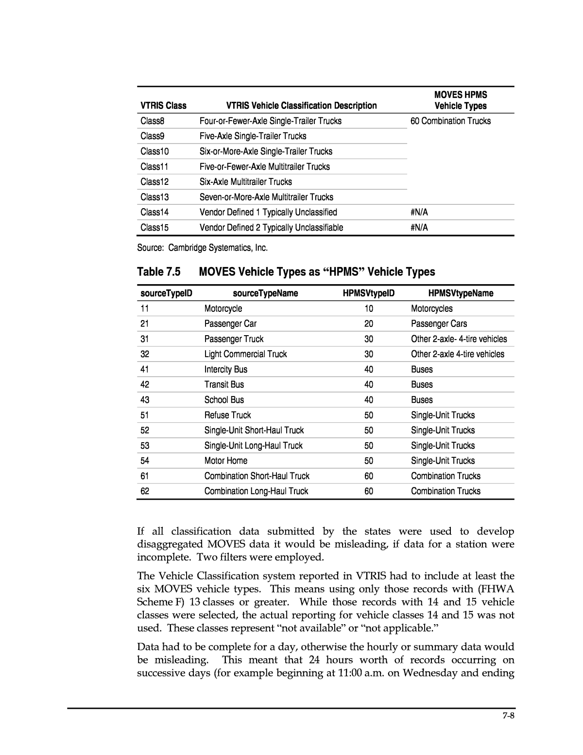
Figure 7.1 Sample On-Line VTRIS Report Source: VTRIS On-Line Table W Generator. https://fhwaapps.fhwa.dot.gov/vtris-wp/. The report generation capability of VTRIS provides summary information that is used to calculate national averages. In 2012, the classification count data submitted by 27 states is stored in the records in the VTRIS Classification Count text files. These VTRIS text files do not appear to include partial-day manual classification counts. This is a primary data collection technique used by many states. The manual counts are used to provide truck percentages that can be used with other reports, such as the ATR reports. However, manual classification methods do not typically collect data when visual observation is not possible, for example at night, and VTRIS may have excluded partial-day manually collected count records. A number of data attribute fields in VTRIS can be equated to data attributes in MOVES. The VTRIS Function Classification (FC) for the road on which the counting station is located is the same Functional Classification attribute as used in the post-2010 state submittals of HPMS data, and is the same FC used in most data analysis managed by FHWA. It has the same meaning and purpose as the Road Types attribute in MOVES. The crosswalk between the VTRIS FC and the MOVES Road Type is shown in Table 7.3. Note the MOVES Road Type of 1 for Off-Road will have no correspondence in VTRIS. 7-6
Table 7.3 VTRIS Functional Classification (FC) as MOVES Road Type FC Code FC Description MOVES Road Code MOVES Road Type 1R Interstate, Rural 2 Rural restricted access 2R Principal Arterial, Rural 3R Principal Arterial, Rural 3 Rural unrestricted access 4R Minor Arterial, Rural 5R Major Collector, Rural 6R Minor Collector, Rural 7R Local, Rural 1U Interstate, Urban 4 Urban restricted access 2U Principal Arterial, Urban 3U Principal Arterial, Urban 5 Urban unrestricted access 4U Minor Arterial, Urban 5U Major Collector, Urban 6U Minor Collector, Urban 7U Local, Urban The VTRIS classification of the vehicle can be one of seven types of classification systems, but those with less than the six vehicle types used in MOVES are not useful in this analysis. For those systems with more than six classes, the crosswalk between the VTRIS vehicle classifications, also known as FHWA Scheme F in the TMG, and the MOVES Vehicle Types is shown in Table 7.4. The MOVES âHPMSâ Vehicle Types correspond to the more detailed MOVES Vehicle Types as shown in Table 7.5. Table 7.4 VTRIS Vehicle Classification as HPMS MOVES Vehicle Types VTRIS Class VTRIS Vehicle Classification Description MOVES HPMS Vehicle Types Class1 Motorcycles 10 Motorcycles Class2 Passenger Cars 20 Passenger Cars Class3 Other Two-Axle, Four-Tire Single-Unit Vehicles 30 Light-Duty Trucks Class4 Buses, passenger-carrying buses with two axles and six tires or three or more axles 40 Buses Class5 Two-Axle, Six-Tire, Single-Unit Trucks 50 Single-Unit Trucks Class6 Three-Axle Single-Unit Trucks Class7 Four-or-More-Axle Single-Unit Trucks 7-7
VTRIS Class VTRIS Vehicle Classification Description MOVES HPMS Vehicle Types Class8 Four-or-Fewer-Axle Single-Trailer Trucks 60 Combination Trucks Class9 Five-Axle Single-Trailer Trucks Class10 Six-or-More-Axle Single-Trailer Trucks Class11 Five-or-Fewer-Axle Multitrailer Trucks Class12 Six-Axle Multitrailer Trucks Class13 Seven-or-More-Axle Multitrailer Trucks Class14 Vendor Defined 1 Typically Unclassified #N/A Class15 Vendor Defined 2 Typically Unclassifiable #N/A Source: Cambridge Systematics, Inc. Table 7.5 MOVES Vehicle Types as âHPMSâ Vehicle Types sourceTypeID sourceTypeName HPMSVtypeID HPMSVtypeName 11 Motorcycle 10 Motorcycles 21 Passenger Car 20 Passenger Cars 31 Passenger Truck 30 Other 2-axle- 4-tire vehicles 32 Light Commercial Truck 30 Other 2-axle 4-tire vehicles 41 Intercity Bus 40 Buses 42 Transit Bus 40 Buses 43 School Bus 40 Buses 51 Refuse Truck 50 Single-Unit Trucks 52 Single-Unit Short-Haul Truck 50 Single-Unit Trucks 53 Single-Unit Long-Haul Truck 50 Single-Unit Trucks 54 Motor Home 50 Single-Unit Trucks 61 Combination Short-Haul Truck 60 Combination Trucks 62 Combination Long-Haul Truck 60 Combination Trucks If all classification data submitted by the states were used to develop disaggregated MOVES data it would be misleading, if data for a station were incomplete. Two filters were employed. The Vehicle Classification system reported in VTRIS had to include at least the six MOVES vehicle types. This means using only those records with (FHWA Scheme F) 13 classes or greater. While those records with 14 and 15 vehicle classes were selected, the actual reporting for vehicle classes 14 and 15 was not used. These classes represent ânot availableâ or ânot applicable.â Data had to be complete for a day, otherwise the hourly or summary data would be misleading. This meant that 24 hours worth of records occurring on successive days (for example beginning at 11:00 a.m. on Wednesday and ending 7-8
at 11:00 a.m. on Thursday), which might be considered by the submitting state as a complete day, would be dropped. However, these data could not be used for day of the week or other summaries in any event. In the example above it could not be said that the day would be either Wednesday or Thursday. If the data were used, it would create a partial day for each day. The data that were available from the VTRIS 2012 Classification Count text file consists of over 10 million records. Only 0.7 percent of those records, with a nonblank classification method, were identified as being collected by manual methods. This confirms the supposition that any data that were submitted using manual methods that had less than 24 hours of data for a station were not retained as VTRIS Classification Count records. Over 4,000 stations remained after the filtering was done. However, a station could be for different lanes in the same location (e.g., right most travel lane, second lane from the right). Stations could also represent different directions on access control facilities (e.g., northbound and southbound reported separately). The number of stations by VTRIS Functional Classification and MOVES Road Type is shown in Table 7.6. As would be expected for a FHWA data collection program, those stations are primarily on Federal Aid Roads (i.e., excluding Rural Minor Collectors and Urban and Rural Local roads). However, the number of stations appears reasonably robust for each MOVES Road Type. On average each station represents data for over 87 days. Table 7.6 Filtered Stations by VTRIS Functional Classification and MOVES Road Type VTRIS MOVES FC FC Description Number of Stations Percent of Stations by MOVES Road Type Road Type Number of Stations 1U Interstates, Urban 1,005 73.6% Urban restricted access 1,366 2U Other Freeways and Expressways, Urban 361 26.4% 3U Other Principal Arterials, Urban 742 79.7% Urban unrestricted access 931 4U Minor Arterials, Urban 162 17.4% 5U Collectors, Urban 24 2.6% 7U Locals, Urban 3 0.3% 1R Interstate, Rural 610 100.0% Rural restricted access 610 3R Principal Arterial, Rural 917 62.7% Rural unrestricted access 1,463 4R Minor Arterial, Rural 329 22.5% 5R Major Collector, Rural 198 13.5% 6R Minor Collector, Rural 17 1.2% 7R Local, Rural 2 0.1% Total 4,380 4,380 Source: Cambridge Systematics, Inc. from 2012 VTRIS data. 7-9
The number of locations, combining stations for the same location but with more than one station by lane or direction, is almost 1,400. Those locations are shown in Table 7.7. As would be expected this reduces the percentage of stations on multilane, multidirectional access restricted facilities, but does not appreciably change the assessment that a sufficient number of locations exist to use the VTRIS data to develop MOVES sample data. Table 7.7 Filtered Stations by VTRIS Functional Classification and MOVES Road Type VTRIS MOVES FC FC Description Number of Stations Percent of Stations by MOVES Road Type Road Type Number of Stations 1U Interstates, Urban 273 73.58% Urban restricted access 371 2U Other Freeways and Expressways, Urban 98 26.42% 3U Other Principal Arterials, Urban 215 77.62% Urban unrestricted access 277 4U Minor Arterials, Urban 53 19.13% 5U Collectors, Urban 7 2.53% 7U Locals, Urban 2 0.72% 1R Interstate, Rural 190 100.00% Rural restricted access 190 3R Principal Arterial, Rural 321 56.71% Rural unrestricted access 566 4R Minor Arterial, Rural 149 26.33% 5R Major Collector, Rural 87 15.37% 6R Minor Collector, Rural 8 1.41% 7R Local, Rural 1 0.18% Total 1,404 1,404 Source: Cambridge Systematics, Inc. from 2012 VTRIS data. The selected stations represent a wide range of geographies, although Floridaâs and Virginiaâs intensive data collection programs dominate the selected stations by each state, as shown in Table 7.8. Although 27 states submitted information to VTRIS, and 26 remained after filtering eligible locations, some provided only a very small number of count stations. Not all road types may be covered in these states. Furthermore, the data from states with small numbers of stations for any given road type should be used with caution as they may not be representative of the State as a whole. 7-10
Table 7.8 Selected VTRIS Classification Locations by State State Rural Restricted Rural Unrestricted Urban Restricted Urban Unrestricted Total Percent of U.S. Arkansas 10 31 5 5 51 3.6% Colorado 12 30 12 8 62 4.4% Delaware 0 12 0 5 17 1.2% Florida 20 82 44 79 225 16.0% Hawaii 0 8 5 28 41 2.9% Idaho 2 11 0 3 16 1.1% Indiana 13 30 23 12 78 5.6% Iowa 0 6 0 0 6 0.4% Maine 2 13 0 0 15 1.1% Maryland 4 2 2 1 9 0.6% Massachusetts 0 0 8 2 10 0.7% Minnesota 6 39 7 6 58 4.1% Mississippi 12 39 13 15 79 5.6% Missouri 14 59 39 4 116 8.3% Montana 15 26 0 0 41 2.9% Nebraska 6 13 3 6 28 2.0% Nevada 4 6 4 2 16 1.1% New Hampshire 1 0 3 0 4 0.3% New Mexico 3 20 1 0 24 1.7% New York 0 0 8 0 8 0.6% Ohio 15 42 56 18 131 9.3% Pennsylvania 3 19 4 8 34 2.4% Rhode Island 1 1 45 1 48 3.4% Virginia 46 75 87 73 281 20.0% West Virginia 0 2 2 1 5 0.4% Wyoming 1 0 0 0 1 0.1% Total 190 566 371 277 1,404 Source: Cambridge Systematics, Inc. from 2012 VTRIS data. VTRIS Data Analysis The MOVES inputs that could be developed for some or all of the states submitting to VTRIS are shown in Table 7.9, along with comments on whether VTRIS is an adequate data source for the development of each input. 7-11
Table 7.9 Sample State-Level Data Produced from 2012 VTRIS Table Name Data Shown Comments HPMSVTypeYear VMT fractions by vehicle type are shown, which may be applied to current and/or local estimates of total VMT. Not recommended as a source of light-duty fractions (type 10, 20, 30) due to difficulty in distinguishing these vehicle types. May be used for light versus heavy-duty fractions and for fractions within heavy-duty categories (40, 50, 60). dayVMTFraction Day fractions shown by HPMS vehicle type and road type. Should be suitable for use. Apply caution for states and road types with small numbers of stations. hourVMTFraction Hour fractions shown by HPMS vehicle type, road type, and day type. Should be suitable for use. Apply caution for states and road types with small numbers of stations. monthVMTFraction Month fractions shown by HPMS vehicle type for State of Maine, rural road types only. In VTRIS, only Maine provided a full year of data. Some state DOTs may be able to provide similar data not submitted to VTRIS. roadTypeVMTFraction Road type VMT fractions are shown by vehicle type. Not recommended for use at a state level. These should be developed from expanded sample data; direct measurements from VTRIS will be biased to road types where counters are located. Queries were developed in Microsoft Access to summarize the 10 million records into records of volumes of MOVES Vehicle Types by date, by hour, by state and by MOVES Road Type and to export that information to Excel. The WEEKDAY function was applied to the calendar date to determine the day of the week. The resulting summary consisted of over 212,000 records. To develop day VMT fractions, the MOVES dayID code for weekday, 5, was determined by using records with a day of the week Monday through Friday. The MOVES dayID code for weekends, 2, was determined by using records with a day of the week of Saturday or Sunday. Zeroes are entered for MOVES Road Type 1, off road, since VTRIS would have no information for this road type. There is no information in VTRIS, i.e., #N/A, for counts for any vehicle type on Urban Restricted Roads for the months of May (5), June (6), or July (7). The values for April may be used to populate the missing values for May and the values for August may be used to populate the missing values for June and July. In order to develop the MOVES table of hour VMT fractions, the selected data records were summarized for Average Daily Traffic (ADT) count by Weekday ID, hour, MOVES HPMS Vehicle Type, and MOVES Road Type. Zeroes are again listed for all MOVES Road Type 1 because off-road counts are not included in VTRIS. While the expected value is for VMT, properly VTRIS records are ADTs for counting stations that cover segments of indeterminate lengths. If available, those lengths could be multiplied by the ADTs to develop VMT. For 7-12
purposes of developing this table of intensity, however, an assumption is made that each section represents an equal length of roadway. In order to develop the MOVES table of month VMT fractions it would be necessary to obtain VTRIS records from stations that provided counts for each day of the year. Only one state, Maine, provides classification stations with sufficient days and it provides it for only two road types, Rural Restricted and Rural Unrestricted. Also the VTRIS data are for 2012, a leap year. In order to develop VMT fractions by MOVES vehicle type, the selected VTRIS records were summarized by MOVES Vehicle Type. The initial result of this processing is shown in Table 7.10. As noted previously, VTRIS reports ADT, not VMT. Using the ADT as a surrogate has two problems. First the classification collection methods are known to have difficulty distinguishing among MOVES vehicle types 10, 20, and 30. However more importantly for this table, VMT is being computed across all MOVES Road Types. For this purpose, the VMT should be a statistically derived and expanded sample. For comparison, the shares of VMT by MOVES Vehicle Type are computed using Virginia DOT published reports of adjusted VMT by Vehicle Type.9 This comparison shows that the use of VTRIS ADT as a surrogate for VMT is most probably incorrect for this table. Instead it is recommended that these data be developed from tables in the readily available FHWA Highway Statistics Series. This will be discussed in the next section. Table 7.10 HPMS Vehicle Type VMT Share for Base Year HPMS VehtypeID yearID ADT Initial VTRIS Base Year ADT Share VA DOT 2010 VMT Share Annual VMT (Millions) Highway Statistics VMT Share 10 2012 400,744,619 13.0% 0.32% 10,932 0.6% 20 2012 1,927,347,975 62.7% 78.64% 2,092,050 68.3% 30 2012 496,484,406 16.1% 14.99% 548,568 20.6% 40 2012 9,980,043 0.3% 0.51% 10,766 0.5% 50 2012 6,7071,652 2.2% 1.24% 77,866 3.7% 60 2012 17,4407,174 5.7% 4.30% 121,973 6.2% 9 Motorcycle VMT reporting is optional and Automatic Equipment has difficulty distinguishing between Classes 1, 2, and 3. The MOVES Vehicle Type percentages for Virginia DOT were computed according to http://www.virginiadot.org/info/ resources/2010/VMTReport_220_2010.pdf. 7-13
Conclusions VTRIS appears to be a useful source for MOVES temporal sample data for states that have provided data to FHWA. While examples from the entire VTRIS sample are shown in the Practitionersâ Handbook, the Excel tool allows the user to summarize the data for a selected state. The VTRIS Classification Count data are developed from counts submitted by state DOTs. It is possible that classification counts are available that were not submitted or retained in VTRIS, and that these classification counts could be obtained directly from a state DOT and processed in the same manner as this VTRIS data. The processing of the VTRIS data as summary records by state and by road type and by date has additional advantages. The VTRIS selected records can be filtered for select state, days of the week and Road Type to develop hourly percentages of usage for MOVES Vehicle Types. These filtered records can be used to develop tables and charts of hourly usage. Such tables and charts can be prepared for any combination of characteristics of Road Type, Day, and State. The Excel files were developed to allow such tables and charts to be developed interactively. Highway Statistics Series There is a source of readily available statistically sampled and expanded VMT by state. That VMT is reported in FHWAâs annual Highway Statistics Table VM-2. The HSS also reports VMT by state by the six âHPMSâ vehicle types used in MOVES in Table VM-4. Apparently because of the additional processing that is necessary to prepare this table, the release of this table lags by a year from the regular on-line release of HSS tables, and the location of this table is not included as a shortcut from the main HSS page for the most current year. Table VM-4 was obtained for 2010,10 which required the use of Table VM-211 from the same year. An Excel file was prepared which uses the state information of percentage share of VMT by HPMS Vehicle Type by Road Type and applies that to the total VMT by state by Road Type. The product of the percentages of VMT by Vehicle Type and total VMT produces VMT by Vehicle Type. The Excel file containing the 2010 data is provided as one of the products of this research. The file allows users to summarize road type distribution for the six HPMS vehicle types by state, using embedded pivot tables. A user could replace the 2010 VM-2 and VM-4 data with more current data tables as they are published by FHWA. The analysis used reported VMT shares for each state. If shares were desired by Urbanized Area rather than by state, the use of VMT could be from Highway 10 http://www.fhwa.dot.gov/policyinformation/statistics/2010/xls/vm4.xls. 11 http://www.fhwa.dot.gov/policyinformation/statistics/2010/xls/vm2.xls. 7-14
Statistics Table HM-71 in place of Table VM-2. This total of VMT could be disaggregated for any Urban Area using the percentage shares by MOVES Vehicle Type as reported by Table VM-4 for the state in which the Urban Area is located. This method could only provide shares across Urban Restricted and Urban Unrestricted MOVES Road Types, since rural road VMT is by definition not reported in Highway Statistics Table HM-71. The MOVES inputs that could be developed for all states based on HSS reports are shown in Table 7.11. Table 7.11 Sample State-Level Data Produced from 2011 Highway Statistics Table Name Data Shown Comments HPMSVTypeYear VMT fractions by vehicle type are shown, which may be applied to current and/or local estimates of total VMT. HSS Tables VM-2, Total VMT by State by Road Type, and VM-4, Percentage Share VMT by Vehicle Type and Road Type, should be suitable for use. roadTypeVMTFraction Road type VMT fractions are shown by vehicle type. HSS Tables VM-2, Total VMT by State by Road Type, and VM-4, Percentage Share VMT by Vehicle Type and Road Type, should be suitable for use. Intelligent Transportation Systems Data The Georgia Department of Transportation (GDOT) maintains an archive of traffic data collected through a network of video cameras on freeways within a seven-county portion of the Atlanta metropolitan area. Video image processing is used to derive volumes, speeds, and lane occupancies at five-minute intervals. Each detector is associated with a segment length, which is about 0.37 mile between two adjacent detectors. Coverage on the regional freeway network is shown in Figure 7.2 in red lines, with the seven county area outlined in blue. Similar to the ITS system in Atlanta, the Florida Department of Transportation (FDOT) collects ITS data on the freeways in Jacksonville metropolitan area. Video imaging and radar technologies are used to collect volumes, speeds, and lane occupancies at five-minute intervals. Each detector is also associated with a segment length, which is about 0.44 mile between two adjacent detectors. For the purposes of this analysis, data were obtained for 2010 in Atlanta, and 2012 in Jacksonville, respectively. The years were chosen to be close to the time periods in other data sources for comparison purposes. The other reason to use 2010 data in Atlanta instead of more recent data is that their ITS system had a major upgrade in 2011, and the data was not complete during the upgrade period. Only weekdaysâ data are used for this study. 7-15
Figure 7.2 ITS Coverage in Atlanta Since the archived data were collected at the lane level, additional aggregation procedures were applied to generate the total volumes and average speed across all at each directional detector site at five-minute intervals. These aggregation procedures and the associated quality controls were processed following FHWA guidelines. After the data aggregation and quality control (QC), MOVES speed bins were then assigned to each five-minute speed. The specific steps for processing the five-minute lane data into speed distributions for MOVES were as follows: 1. Conduct quality control checks on the data records, following guidelines published by FHWA (2004). All the speeds less than 5 mph were reset to null since past studies suggested that data were not reliable when speed was less than 5 mph. Null values due to reset speeds, and missing data due to equipment failures, were discarded from the dataset. In the Atlanta dataset, 37 percent of time intervals have a valid vehicle-hours of travel (VHT) number. The data were evaluated to ensure there was not a bias in the missing data to a specific time period (hour of the day). 2. Aggregate speeds and traffic volumes across lanes to obtain an average speed and total volume by direction for each link. This was done by summing the individual lane traffic volumes, and averaging the speed for each lane, weighted by the volume in the lane. 7-16
3. Calculate the VHT on each link as follows: VHT = Volume * length (mi)/speed (mi/hr). 4. Assign each five-minute link directional speed to a MOVES speed bin. 5. Sum the VHT in each speed bin across all link segments and all five-minute intervals in each hour time period. 6. Divide VHT in each speed bin by total VHT for the hour time period to obtain the fraction of VHT by speed bin for the hour. Repeat for all 24 hours. In addition to missing data due to equipment failures, any observation that failed QC was also reset to a null value. Overall, 37 percent of the time intervals have a valid VHT number in Atlanta, and 50 percent of the time intervals have a valid number in Jacksonville. A closer look at the missing data in these two metropolitan areas showed no patterns in the amount of missing data by hour of the day. As such, all the processed data were included in the final aggregation to produce the hourly speed bin distributions. After the speed bins were assigned, the final aggregation (described in detail in the next section) summed up all the VHT for each speed bin at each hour during a year, and the hourly VHT totals were also calculated. The hourly speed bin fractions are calculated by dividing the speed binâs VHT in that hour by the hourly total VHT. Speed Data Aggregation There are different ways of aggregating the data to create speed distributions. Two approaches were tested for this project using the Atlanta data: ⢠Aggregating five-minute interval speeds without any averaging; and ⢠Averaging each five-minute interval across a day of week and month and then creating a speed distribution based on the average for all time periods. The first approach is clearly preferable for the purpose of MOVES inputs, since it creates what is as close as possible to an actual distribution of speeds that may be observed over the course of a day, month, or year. The second approach was demonstrated to illustrate the difference that can be introduced by the aggregation method. This is important because other sources of speed data â notably private vendor data â typically are provided at a higher level of aggregation, i.e., average speed by link across multiple days. Travel demand model speed outputs also represent average speeds, since they are derived from a deterministic equation using average volume and capacity as inputs. A comparison of speed distributions for four representative time periods â overnight (5:00-6:00 a.m.), AM peak (7:00-8:00 a.m.), midday (11:00 a.m.- 12:00 p.m.), and PM peak (5:00-6:00 p.m.) shows that averaging the data does produce significantly different speed distributions. The overall average speed is only slightly lower for the disaggregate data, but there is a substantially higher fraction of travel shown at lower speeds, which is important for emissions 7-17
modeling. For example, in the peak periods, the aggregated data shows only 1 percent of VHT less than 27.5 mph, whereas the disaggregated data shows 11 percent in the AM peak and 18 percent in the PM peak. The comparison is shown in Table 7.12. Table 7.12 Comparison of Aggregated and Disaggregated ITS Speeds Atlanta Freeways Parameter Overnight (5:00-6:00 a.m.) AM Peak (7:00-8:00 a.m.) Midday (11:00 a.m.- 12:00 noon) PM Peak (5:00-6:00 p.m.) Based on disaggregate five-minute Intervals Average speed 64.2 55.3 63.7 50.9 Percent of VHT < 27.5 mph 1% 11% 1% 18% Based on average of five-minute speeds over day of week and month Average speed 64.4 57.4 64.0 54.3 Percent of VHT < 27.5 mph 0% 1% 0% 1% Temporal Distributions To create temporal distributions (VMT fractions by hour, day of week, and month), VMT (calculated as volume * segment length) was aggregated across all of the available five-minute observations for each respective time period (hour, weekday versus weekend, and month) and divided by total VMT to obtain the hour, day, or month fraction. This source is limited since only restricted-access roadways are covered, so unrestricted access road fractions cannot be developed for hour or day fractions. Also, the ITS data do not distinguish vehicle types, so separate distributions by source type cannot be developed. Private Vendor Data In recent years, there has been increasing availability of speed monitoring data from various technologies made available through private vendors. Sources include GPS data from mobile multifunction devices such as smartphones, phablets, tablets and a handful of in car bidirectional GPS, entertainment/ communication software packages offered by various auto manufacturers. Data are aggregated and resold by firms, including INRIX and NAVTEQ. The research team obtained NAVTEQ data for the Atlanta metro area and INRIX data for the Jacksonville metro area for purposes of this research. Unlike the ITS systems that collect data mainly on freeways, private vendorsâ data cover a much wider range of roadway types. For example, compared to 105 directional freeway miles in the Jacksonville ITS dataset, the traffic management center (TMC) network in Jacksonville, with which the INRIX speed data are 7-18
associated, has 388 directional miles on functional class 1 roads, and 3,983 directional miles on other FC roads. The disadvantages of the private sources include: ⢠There is no volume data, which is important for weighting the speeds to obtain VHT distributions. ⢠TMC functional classes are not consist with HPMS functional classes: â While all TMC FC 1 roads are freeways, some TMC FC 2 roads are access- controlled expressways while others are arterials, so the classes do not line up neatly with MOVES road types; and â There is no urban or rural designation in the TMC FC, so this must be determined from a spatial overlay of the urbanized area boundaries. ⢠The data are typically provided as averages over multiple days for a given time period, rather than in disaggregate format to reflect day-to-day variations. ⢠Missing data are a concern. Some vendors use historical data to interpolate missing data, while others leave them blank. ⢠There is a cost for acquisition (unless the data have already been purchased for another use and can be licensed for this purpose as well). Currently, the project team is attempting to match the NAVTEQ and INRIX networks to state DOTsâ existing inventory maps to obtain volumes and other roadway characteristics. Atlanta Metropolitan Area NAVTEQ data were obtained for the Atlanta metro area through the Atlanta Regional Commission (ARC). The data had been purchased by ARC and were made available to the project team at no cost. The data are hourly average speeds aggregated across all days in 2010, for network links corresponding to the Atlanta NAVTEQ network. NAVTEQ does not reveal either the source or sample size of its data. NAVTEQ data also has information for link length and link FC. There are five NAVTEQ FCs, where FC 1 links are freeways, and some FC 2 links are access- controlled expressways. Jacksonville Metropolitan Area INRIX data were obtained for the six-county Jacksonville metro area through the Florida DOT.12 The data had previously been purchased by FDOT and were 12 Baker, Clay, Duval, Nassau, Putnam, and St. John Counties. 7-19
made available to the project team for a modest additional licensing fee. The data included five-minute speed speeds on network links corresponding to the Jacksonville TMC network during July 2010 to June 2011. Similar to ITS data, the INRIX speed is the speed on a TMC link for a particular five-minute interval, not aggregated over other time periods. INRIX does not reveal either the source or sample size of its data. INRIX also provided TMC configurations which included information such as TMC location, length, type (mainline or ramp), and functional class. The FC is the standard FC associated with the TMC network. There are five TMC FCs, where FC 1 TMC are freeways, and some FC 2 TMC are access-controlled expressways. Spatial Joining of Speed and Volume Data In both Atlanta and Jacksonville, significant difficulties were encountered in attempting to join speed data with traffic volume data. To be used to assist with speed calibration, it is necessary to join the geographic speed data obtained from private sources to travel model or other vehicle activity data, so that speeds can be weighted by traffic volumes to produce regional distributions of speed by VHT. If speed distributions are based on unweighted data, speeds on low- volume roads will be overrepresented, and speeds on high-volume roads will be underrepresented. Speed data are typically associated with a traffic management center network while volumes obtained from a model are associated with the travel demand model network. Typically, these networks are disparate and may not be in close geographic alignment. Geographic information systems (GIS) procedures involving a combination of automated and manual coding must be applied in order to match the two networks with a reasonable degree of accuracy. The specific procedures applied, and issues encountered, are described below. In summary, two approaches were attempted. The first was to use traffic volumes from the travel demand model network. Attempts to automate the join process were unsuccessful and a significant amount of manual coding would have been required. A second approach was to use a network which had traffic volumes associated from the FDOT Office of Safety. However this network also turned out to be difficult to match. Finally, ARC staff assisted in providing matched speed and volume data for Atlanta, but by the time the data were available in the format required for this research, the available budget for this effort had been depleted. Combining speed and volume data in other areas is likely to require extensive manipulation unless the data are produced and stored with the same geographic extent and projections. The approach utilized will necessarily depend on the locally available data for the state and/or MPO in question. Longer term, efforts to do this would benefit from efforts in the transportation planning/engineering community to move towards standardization of input file formats, specifically regarding geographies used for collection of data. 7-20
The remainder of this section illustrates the approaches attempted to join speed and volume data from Jacksonville. Approach 1 â Use Model Network Volumes In this approach, an attempt was made to use the travel model loaded network with average annual daily traffic (AADT) to append speeds. The following files were used as data sources: ⢠Cube Voyager Loaded True Shape Network; ⢠INRIX shapefile with TMC codes used to associate with measured real world speeds in the INRIX database; and ⢠Road name table to allocate names to specific INRIX segments. The first step in this process involved the export of the Cube âTrue Shapeâ network to an ESRI shapefile. This was done in order to allow geographic manipulation of the network via overlay techniques. The overlay was done as a sequence of steps set up to ensure the best possible matches. The steps were as follows: 1. The exported true shape links from Cube contained duplicate entries where roads are single line coded. Figure 7.3 illustrates the example. Figure 7.3 Apparent Single Link Represented by Two Records for Each Direction a. For such links, a direction attribute was added such that it became possible to distinguish between the directions for the overlay (spatial join) process. 7-21
b. Dual line coded links (single entries without duplicates) representing each direction of travel were left unchanged. Figure 7.4 illustrates. Figure 7.4 Dual Line Coded Links Represented by a Record for Each Direction 2. Each direction on the TMC shapefile was selected and saved. 3. Each direction on the exported loaded network also selected and saved separately. 4. The road name table was joined to the TMC shapefile and used to further refine selection. 5. Interstate and dual line coded roadways were overlaid using matching selections on the INRIX and model loaded shapefile. This minimized instances of the wrong TMC code direction being transferred to the loaded network file. a. NB to NB. b. SB to SB. c. EB to EB. d. WB to WB. 6. The overlay was then successively completed per direction and per road type (separate dual line coded or duplicate single line representation). Figure 7.5 illustrates the results of the overlay for a small area to the southeast of Downtown Jacksonville with the TMC codes displayed in red (INRIX file) and green (model file). 7-22
Figure 7.5 Overlay Result Example Problems with this approach: ⢠At points where links intersect, the overlay produced inaccurate results. Figure 7.6 illustrates an example of this where several perpendicular links were assigned the same TMC code. ⢠The required correction of erroneous overlay results would be extensive for all instances of such occurrences. ⢠The model network did not directly contain HPMS functional class which would require a further spatial join to append. 7-23
Figure 7.6 Example of Spurious Overlay Approach 2 â Use State DOT AADT Source Files Owing to the problems with the first approach, a second approach was undertaken whereby a Florida DOT count data geographic file was used. The following lists the files utilized in the process: ⢠FDOT Office of Transportation Safety shapefile with AADT information encoded per segment; ⢠2010 NAVTEQ-derived street network; and ⢠Correspondence table to link NAVTEQ network with TMC codes which provide the key for speed data. In this approach, given the similar geographic extent of the NAVTEQ and the Safety Office network, the following sequence of steps was followed: 7-24
1. The 2010 NAVTEQ network was converted from a line shapefile to a point shapefile to aid in spatial join accuracy. 2. The FDOT Safety Office shapefile was then overlaid on the converted point file from step 1. The result of this process was a shapefile with both AADT attributes, and a key (called Link_ID) that allows for a correspondence with the TMC codes used to append speed data. 3. The updated shapefile was then joined in a tabular manner via the Link_ID key to a TMC, Link_ID correspondence file. This process allows the speed information from INRIX to be appended. 4. As was the case with the model approach, it was necessary to append HPMS functional classes to the shapefile with the TMC codes. a. This process was a spatial join and also produced inaccurate results with several incorrect HPMS categories being appended to specific model links. Examples include arterials being assigned to Interstates and vice versa. b. Given that ultimately, the required result was the MOVES road type categorizations, it was possible to enhance the accuracy by manually assigning controlled access facilities and using the HPMS code for urban/ rural designations only. c. Interstates and all the expressway roads in Jacksonville were identified via selection and coded and MOVES types 2 or 4, depending on the HPMS code. It was thought that while not good enough for the road type categorization, the area type categorization implicit in the HPMS code is spatially accurate and could thus be used for this purpose. GPS Data from Travel Surveys A number of metropolitan areas have experimented with the use of GPS to support travel survey data collection. GPS traces can be used to identify vehicle speeds on specific roadways by time of day. Therefore, a sample of GPS records could be used to develop speed distributions for both urban restricted and unrestricted roadway types in the areas in which such surveys have been conducted. Because the survey includes a limited sample of travelers for a short- duration time period, the sample of speeds is much more limited than obtained from ITS data or other sources of continuous observation. The driving patterns of the sampled travelers are also not guaranteed to be representative of the overall distribution of traffic by type of road, time of day, or location. However, the GPS method does have the significant advantage of collecting disaggregated data (i.e., not averaged across multiple days) for all types of roadways. The National Renewable Energy Laboratory (NREL) maintains an archive of GPS travel survey data through its Transportation Secure Data Center. The center addresses data privacy issues by providing easy access to nonspatial data, or by providing access to spatial data in a more restricted environment. One of the 7-25
datasets is a GPS subsample in The 2011 Regional Travel Survey conducted by the Atlanta Regional commission. This GPS subsample includes 1,061 households that logged 40,000 trips. For GPS participants, data were recorded for a maximum of seven days. NREL matched each individual trip to the roadway traveled, and reported the distance traveled and average speed by roadway functional classes on each trip.13 The project team applied minimal processing to determine VHT speed distributions based on speeds and segment lengths by roadway type (restricted and unrestricted access). Travel Demand Forecasting Models and Speed Postprocessing Travel demand forecasting models can produce forecast year as well as historical year speed estimates and are widely used for estimating vehicle speed distributions for input to emissions models. However, state-of-practice travel demand models have a number of limitations for speed estimation. Postprocessing techniques can be applied to improve model speed estimates as well as to disaggregate volumes and speeds from time period (e.g., AM peak) to the hourly level. While postprocessing methods do not eliminate some of the more fundamental limitations of speed estimation procedures, they represent the best that most agencies (short of having a large-scale microsimulation model with dynamic traffic assignment) have to work with for predicting speeds under future traffic conditions. The most common postprocessing method involves the use of the so- called Bureau of Public Roads (BPR) function with coefficients that are either locally calibrated or transferred from other areas. However, other volume-delay functions also have been developed, as discussed in the Practitionersâ Handbook Volume 1, Section 4.7. In this research, data from the Atlanta and Jacksonville travel demand models were used to compare the speed distributions produced by various volume-delay functions with observed speeds from the ITS, private vendor, and GPS sources described above. Jacksonville Travel Demand Model For the Jacksonville metro area, travel demand model data and outputs were obtained, including road types, capacity, volumes, and speeds by link, along with network shapefiles, from the Northeast Regional Planning Model V4.0 (NERPM4) maintained by First Coast MPO. The base year for the model was 2005, which was used to develop speed distributions. Model facility types were classified by the project team into the MOVES facility types (restricted and 13 Instead of FHWAâs HPMS functional class, NREL used NAVTEQ functional class. In this study, NAVTEQ FC 1 is assumed to be access-controlled roads, while other NAVTEQ FC roads are assumed to be nonaccess-controlled. 7-26
unrestricted access). While some portions of the model cover areas categorized as âruralâ area type, only the segments falling within the urban area boundaries were used for this comparison. The Jacksonville model contains four time periods (AM peak, midday, PM peak, and overnight). The model speeds are not postprocessed and are therefore specific to time period rather than hour. The model speeds are calculated using a BPR equation with coefficients specific to facility and area type as shown in Table 7.13. The model network was coded with hourly lane capacities. The capacity was adjusted to reflect the congestion during peak hours (the âCONFACâ factor described in the model documentation),14 an adjustment which essentially determines the speeds based on the peak-hour v/c ratio, rather than the v/c ratio over the entire time period. Table 7.13 BPR Coefficients Used in Jacksonville Model Facility Type BPR Coefficient (α) BPR Exponent (β) Freeways/Expressways/Parkways 0.450 6.75 Divided Arterials 0.490 4.35 Undivided Arterials 0.500 3.75 Local Roads/Transit Only Driveway Links 0.510 3.15 Centroid Connectors/Externals/Transit Only Platform- Escalator and Walk Access Link 0.100 2.50 One-Way Facility Unsignalized/Class 1b/Class II-III 0.530 4.50 Frontage Road Class 1b/Class II-III/Transit Skyway Links 0.475 5.25 Ramps 0.475 4.85 For this research project, the project team applied a postprocessing procedure to develop speeds by hour. This procedure used the same equation and coefficients as used for the model calculations. However, the CONFAC factor was not applied as this is not appropriate if the calculation is done for individual hours. VMT within each model period was further disaggregated to individual hours using the MOVES embedded hourly VMT distribution. Hourly speeds for each link were then calculated using the estimated hourly volume and link-specific hourly capacity from the model. 14 The Corradino Group and PBS&J, Inc. (2009). Northeast Regional Planning Model V4.0: Draft Technical Report 1 and 2: Model Data, Calibration, and Validation. Prepared for First Coast MPO and Florida DOT â District 2. 7-27
Atlanta Travel Demand Model For the Atlanta metro area, travel demand model data and outputs were obtained, including road types, capacity, volumes, and speeds by link, along with network shapefiles, from the model maintained by the Atlanta Regional Commission. The base year for the model was 2000 and forecast year data was available for 2010. The 2010 data were used for closer comparability with the other data sources. Model facility types were classified by the project team into the MOVES facility types (restricted and unrestricted access). While some portions of the model cover areas categorized as âruralâ area type, only the segments falling within the urban area boundaries were used for this comparison. Because ARC had already conducted postprocessing on model outputs to develop MOVES inputs, the MOVES input files were also obtained directly from ARC. The Atlanta model contains four time periods (AM peak, midday, PM peak, and night). The model speeds are postprocessed. Rather than using the BPR curve or another function, ARC has developed its own table of factors which relate the ratio of congested speed to free-flow speed to v/c ratio. These factors are specific to facility type and time period. Sample factors for freeways and principal arterials are shown in Figure 7.7. Speeds are developed for each hour of the day so as to be compatible with MOVES inputs. Figure 7.7 ARC Model Volume-Delay Factors Source: Atlanta Regional Commission (2008). The Travel Demand Forecasting Model for the Atlanta Region 2008 Documentation. Note that these may not reflect current modeling practice. 0 0.1 0.2 0.3 0.4 0.5 0.6 0.7 0.8 0.9 1 0 0.2 0.4 0.6 0.8 1 1.2 1.4 1.6 1.8 2 Ratio of Congested to Free-Flow Speed v/c ratio Freeway - AM Freeway - Midday Freeway - PM Freeway - Night Princ Art - AM Princ Art - Midday Princ Art - PM Princ Art - Night 7-28
The project team also developed and applied additional postprocessing methods using the BPR curve and other functions, as described in Section 7.3, so that the results of these postprocessing procedures could be compared with observed speeds from the ITS, GPS, and private vendor sources. National Household Travel Survey The National Household Travel Survey (NHTS) is conducted by the U.S. DOT every six to eight years. The survey provides information on trip, vehicle, and household characteristics for a sample of travelers nationwide. The most recent NHTS, conducted in 2009, collected one-day travel data from 150,000 households. Analysis of survey data can be conducted at the state level and for the 50 largest metropolitan areas, using an on-line query tool or by obtaining the data from U.S. DOT. Information was collected on vehicles owned by households, including the type of vehicle, model year, odometer reading, and annual miles driven. The NHTS was investigated as a potential supplemental source in identifying age distributions and source type populations for light-duty vehicles. For source type population input, its utility was investigated for identifying the proportion of light-duty vehicles that are automobiles (type 21) versus light trucks (type 31). The vehicle types in the NHTS and corresponding MOVES source types are shown in Table 7.14. Table 7.14 NHTS Vehicle Types Code NHTS VEHTYPE MOVES Source Type 01 Automobile/Car/Station Wagon 21 02 Van (Mini, Cargo, Passenger) 31 03 Sports Utility Vehicle 31 04 Pickup Truck 31 05 Other Truck 31 06 RV (Recreational Vehicle) 54 07 Motorcycle 11 08 Golf Cart N/A 97 Other N/A For age distribution, it is necessary to know the average annual mileage for each type of vehicle and age group, in order to weight the age groups. Three indicators of annual mileage can be developed: 7-29
1. A estimate self-reported by the survey respondent (ANNMILES); 2. A revised estimate based mainly on reported odometer readings (BESTMILE); and 3. Computed travel miles from the trip file (TOTMILES). For each trip, household vehicle ID is available, if a personal vehicle is used. The trip records also have a driver flag. For such trips, trip distances are aggregated over the household vehicle ID to establish an estimate of VMT. The project team found a wide variation of annual mileage across these estimation methods, states, vehicle types, and age groups, in ways that were not always consistent. Furthermore, vehicles were grouped into five-year age categories and these categories would need to be further broken out by year to develop MOVES inputs. Therefore, given that age distributions for light-duty vehicles can be fairly reliably developed from registration or I/M program data, the project team does not recommend the NHTS as a supplemental or alternative source for age distributions. Sample mileage accumulation data are shown in Table 7.15. Table 7.15 Sample Mileage Accumulation Estimates 2009 NHTS State Vehicle Type MOVES Type Age Category ANNMILES AVG BESTMILE AVG TOTMILES AZ Automobile/Car/Station Wagon 21 0-5 Years 16,392 14,356 12,817 AZ Automobile/Car/Station Wagon 21 5-10 Years 8,335 9,446 13,420 AZ Automobile/Car/Station Wagon 21 10-15 Years 7,308 7,890 11,770 AZ Automobile/Car/Station Wagon 21 15-25 Years 6,806 7,885 4,257 AZ Automobile/Car/Station Wagon 21 Older Than 25 Years 2,860 3,814 968 AZ Sports Utility Vehicle 31 0-5 Years 13,926 16,353 44,221 AZ Sports Utility Vehicle 31 5-10 Years 9,835 11,706 9,975 AZ Sports Utility Vehicle 31 10-15 Years 13,145 12,502 12,229 AZ Sports Utility Vehicle 31 15-25 Years 3,992 5,843 3,944 AZ Sports Utility Vehicle 31 Older Than 25 Years 7,822 7,716 7,314 DE Automobile/Car/Station Wagon 21 0-5 Years 12,272 11,489 13,042 DE Automobile/Car/Station Wagon 21 5-10 Years 9,297 11,630 13,408 DE Automobile/Car/Station Wagon 21 10-15 Years 6,449 8,738 7,175 DE Automobile/Car/Station Wagon 21 15-25 Years 3,213 8,354 2,168 DE Automobile/Car/Station Wagon 21 Older Than 25 Years 1,749 5,155 177 DE Sports Utility Vehicle 31 0-5 Years 13,496 13,025 11,908 DE Sports Utility Vehicle 31 5-10 Years 14,918 18,274 18,160 DE Sports Utility Vehicle 31 10-15 Years 9,209 12,552 26,480 DE Sports Utility Vehicle 31 15-25 Years 2,382 1,916 â 7-30
State Vehicle Type MOVES Type Age Category ANNMILES AVG BESTMILE AVG TOTMILES FL Automobile/Car/Station Wagon 21 0-5 Years 11,079 12,044 11,801 FL Automobile/Car/Station Wagon 21 5-10 Years 9,329 11,051 10,240 FL Automobile/Car/Station Wagon 21 10-15 Years 8,083 9,852 8,478 FL Automobile/Car/Station Wagon 21 15-25 Years 5,841 8,533 5,962 FL Automobile/Car/Station Wagon 21 Older Than 25 Years 2,289 6,664 3,852 FL Sports Utility Vehicle 31 0-5 Years 11,972 13,656 13,325 FL Sports Utility Vehicle 31 5-10 Years 11,159 13,201 12,526 FL Sports Utility Vehicle 31 10-15 Years 9,847 12,155 9,440 FL Sports Utility Vehicle 31 15-25 Years 7,167 8,795 5,541 FL Sports Utility Vehicle 31 Older Than 25 Years 2,612 5,373 7,812 The project team also computed the fraction of MOVES type 21 and 31 vehicles for each state. These fractions are generally consistent with other data sources and appear with expected patterns (e.g., more rural states have a higher proportion of trucks). Therefore, the NHTS could serve as a supplemental source if problems are encountered obtaining or analyzing registration data. The proportion of source type 21 and 31 can be used to break out total VMT for these categories if classification counts do not appear reliable. These proportions by state are shown in the Practitionersâ Handbook Volume 1, Section 4.2. Off-Network Activity Off-network activity (motor vehicle activity which occurs off the roadway network) can be modeled using the project-level input scale of analysis in MOVES. Examples of off-network locations include parking lots, with vehicle start-up and evaporative emissions; truck stops, with long-duration idle emissions; and bus terminals or ports, with low-speed and short-duration idle emissions. Off-network data in a form directly suited to developing MOVES inputs are not collected often; and when such data are collected, they are likely to be site- specific and not representative of other off-network facilities. For the purposes of creating illustrative examples of the use of off-network data, the project team collected and analyzed preexisting data from three different types of facilities: 1. A study at the Port of Houston which gathered data on drayage movements by instrumenting trucks; 2. Traffic count data at a parking lot in Massachusetts (ins and outs by 15-minute time interval); and 3. Data collected on truck idling at rest areas and truck stops in Pennsylvania. 7-31
These examples are fully described in the Practitionersâ Handbook Volume 2, Section 4.07. Commercial Vehicle Data One of the most challenging problems in developing MOVES inputs is to develop state or locally specific data on truck populations (source types 51-54 and 61-62). Vehicles registered in one state are often driven in other states, so VMT data are often used, in conjunction with average miles driven per vehicle, to infer source type population in the modeling domain. However, VMT data based on traffic counters typically only distinguish two types of trucks â single- unit and combination (tractor-trailer). Neither VMT nor registration data can readily distinguish the use pattern of the truck (short- versus long-haul). The research team investigated alternative sources of commercial vehicle data that could potentially provide insights into use patterns, as well as age distributions and annual mileage accumulation, to facilitate the development of locally specific truck activity data. These included primarily the Motor Carrier Management Information System, as well as state commercial vehicle registration databases and the International Registration Program. Motor Carrier Management Information System The Motor Carrier Management Information System contains information on the safety fitness of commercial motor carriers. It is maintained by the Federal Motor Carrier Safety Administration and data can be made available to the public with varying levels of detail. MCMIS data are collected from the MCS-150 form reporting required of motor carriers. Truck owners (carriers) are required to report information, including state of registration; the number of trucks in their fleet by type (single-unit, tractor); total annual miles driven by all trucks in their fleet; use of their trucks (freight versus service, and type of freight carried); and number of trucks registered for intrastate only versus interstate use. The database collects records from interstate and intrastate carriers registered in the United States as well as from interstate carriers registered in Canada and Mexico, segregated by state. The 2012 database reported the activity of over one million firms. For this research, the 2012 MCMIS database was obtained from FMCSA and explored to determine its potential use in characterizing total truck registrations by truck type and state, and average annual VMT by truck, which can be used to convert VMT estimates to source type population estimates, or vice versa. Not all firms reported total VMT. These entries were eliminated from the sample. In addition, some firms reported VMT totals that were very low or improbably high. Given that firms are responsible for self-reporting their data, there is no way to systematically eliminate all faulty entries from the sample. In order to eliminate a substantial percentage of faulty records, all firms that reported an annual total of one million miles or greater per truck were eliminated from the sample. In addition, firms that reported annual totals of 7-32
under 1,000 miles per truck were eliminated. This left a remaining sample of 2.1 million trucks representing 59 billion annual VMT. Despite reporting errors that are common with this type of self-reported data, the data retains a significant degree of validity due to the size of the population and a lack of evidence that instances of misreporting were uniformly biased in one direction. The result of the analysis shows an average utilization of 29,000 miles per truck per year for trucks certified for interstate commerce. For trucks certified only for intrastate commerce, the average is lower at 24,000 miles per year. Since fully utilized trucks can have annual utilization of more than 100,000 miles per year, the data indicates that a substantial number of registered trucks were not fully utilized in 2012. Table 7.16 shows the profile of trucks based on intrastate- and interstate-certified carriers. Table 7.16 Profile of Carriers by Type from MCMIS Database Carrier Type Total Annual Mileage Total Power Units Annual Mileage Per Power Unit Interstate Carriers 43.25 billion 1,482,198 29,180 Intrastate Carriers 15.70 billion 653,096 24,039 Source: Cambridge Systematics, Inc. analysis of 2012 MCMIS data from FMCSA. FHWAâs Highway Statistics, Table MV-9, also provides estimates of trucks registered by state, based on reporting by states. A comparison of the FHWA data and MCMIS data is shown in Table 7.17. Both 2010 and 2011 FHWA data are shown since there was a significant increase in total trucks reported in 2011, possibly due to changes in reporting procedures. (The term âtractorsâ in FHWA reporting is intended to mean all heavy truck power units, including single units and tractors.) Table 7.17 also compares trucks per 1,000 population between the two datasets as an indicator of how âtruck-intensiveâ a state is. Long-haul trucks are often used in states other than those in which they are registered, and in-state truck registrations may not be a good proxy for the in-state population of trucks (especially combination long-haul trucks). A wide variation among states can be seen, as well as some large variations between the FHWA and MCMIS datasets. The data in Table 7.17 provide justification for using VMT-based rather than registration-based methods for estimating heavy truck source type populations. States with relatively low truck registrations are likely to undercount truck populations active in the state, while states with relatively high registrations are likely to overcount them. There is some variation in truck VMT per capita among states, but not nearly as much as the variation in registrations per capita. 7-33
Table 7.17 Registered Trucks by State State FHWA Truck Tractors 2010 FHWA Truck Tractors 2011 MCMIS 2012 Registrations Population Trucks/,1000 (FHWA 2011) Trucks/1,000 MCMIS 2012 Alabama 90,446 37,645 44,282 4,822,023 8 9 Alaska 4,394 4,644 11,559 731,449 6 16 Arizona 22,867 41,970 29,034 6,553,255 6 4 Arkansasa 24,523 39,033 19,105 2,949,131 13 6 Californiad 132,573 248,756 92,802 38,041,430 7 2 Colorado 8,921 28,928 56,328 5,187,582 6 11 Connecticut 2,420 7,161 27,960 3,590,347 2 8 Delaware 1,534 3,329 7,954 917,092 4 9 Dist. of Columbia 231 42 1,547 632,323 0 2 Floridab 241,681 64,757 87,876 19,317,568 3 5 Georgiaa 84,895 69,272 82,871 9,919,945 7 8 Hawaii 1,218 2,817 3,392 1,392,313 2 2 Idaho 32,126 21,499 17,372 1,595,728 13 11 Illinoisc 70,750 145,834 72,679 12,875,255 11 6 Indiana 58,316 212,908 49,939 6,537,334 33 8 Iowaa 49,410 73,196 42,575 3,074,186 24 14 Kansas 28,263 39,407 37,620 2,885,905 14 13 Kentuckya 27,415 30,075 43,435 4,380,415 7 10 Louisiana 42,815 34,350 24,282 4,601,893 7 5 Mainea 3,624 8,725 21,140 1,329,192 7 16 Maryland 17,101 12,484 50,858 5,884,563 2 9 Massachusettsb 13,142 13,199 41,705 6,646,144 2 6 Michigan 17,211 65,319 97,797 9,883,360 7 10 Minnesotaa 35,733 67,507 96,371 5,379,139 13 18 Mississippia 8,776 22,802 19,117 2,984,926 8 6 Missouri 53,902 68,558 46,904 6,021,988 11 8 Montana 19,667 22,106 13,877 1,005,141 22 14 Nebraska 36,305 57,830 31,613 1,855,525 31 17 Nevadaa 7,846 7,898 10,063 2,758,931 3 4 New Hampshire 5,815 5,354 14,614 1,320,718 4 11 New Jerseyb 13,808 40,900 57,222 8,864,590 5 6 New Mexico 13,177 11,848 17,984 2,085,538 6 9 New York 7,136 38,764 124,053 19,570,261 2 6 North Carolina 46,434 69,983 51,659 9,752,073 7 5 North Dakota 9,961 32,334 15,209 699,628 46 22 Ohio 41,809 98,067 62,460 11,544,225 8 5 Oklahomaa 13,110 56,350 38,255 3,814,820 15 10 Oregon 21,385 25,419 34,080 3,899,353 7 9 7-34
State FHWA Truck Tractors 2010 FHWA Truck Tractors 2011 MCMIS 2012 Registrations Population Trucks/,1000 (FHWA 2011) Trucks/1,000 MCMIS 2012 Pennsylvania 71,377 77,655 104,536 12,763,536 6 8 Rhode Islandb 3,472 1,982 8,158 1,050,292 2 8 South Carolina 21,631 25,683 24,880 4,723,723 5 5 South Dakotaa 19,609 23,615 14,544 833,354 28 17 Tennesseea 64,921 47,210 37,123 6,456,243 7 6 Texasa 183,937 220,577 124,396 26,059,203 8 5 Utah 63,468 28,998 22,760 2,855,287 10 8 Vermont 2,943 3,614 6,701 626,011 6 11 Virginia 42,258 37,598 36,196 8,185,867 5 4 Washingtona 35,279 42,657 50,982 6,897,012 6 7 West Virginia 11,582 8,386 19,365 1,855,413 5 10 Wisconsina 53,538 61,877 76,148 5,726,398 11 13 Wyominga 4,411 10,374 11,890 576,412 18 21 Total 1,889,166 2,421,296 2,135,272 313,914,040 Source: FHWA, Highway Statistics 2011, Table MV-9; and analysis of FMCSA Motor Carrier Management and Information System by Cambridge Systematics, Inc. a State did not report active registrations and registers vehicles annually. Annual transaction data shown. b State did not report active registrations and offers multiyear registrations. Data estimated from current and previously published data. c State did not report current year data. Previous year data shown for private vehicles. d State data estimated from Department of Motor Vehicles published data. Other Commercial Vehicle Data Sources Motor carrier registration data may also be obtained directly from state entities. For example, the Texas Motor Carrier Database includes information collected directly from all registered motor carriers in the State. Its collection is independent of the Stateâs vehicle registration database and it is updated monthly. The database contains the vehicle identification numbers (VIN) for all commercial vehicles. From this source, data on the size and characteristics of engines, as well as make and model, can be decoded. It is available through a web interface15 and on CD from the Texas Department of Motor Vehicles. The International Registration Plan collects data from motor carrier fleets for the purpose of apportioning registration fees for carriers operating in multiple states. Information reported includes vehicle type, age, fuel type, weight, and miles driven by state. In theory these data, if obtained in disaggregate format, could be used to estimate truck VMT, miles per vehicle, and age distribution by 15 Texas Motor Carrier Registration Database, available at: http://apps.txdmv.gov/ apps/mccs/truckstop/. 7-35
vehicles registered outside of a state but operating within the state. However, efforts to acquire data for purposes of this research were unsuccessful. The Freight Analysis Framework (FAF) does not provide direct information on vehicle population, but it does provide information on truck flow patterns that can help to identify short- versus long-haul movement. The FAF is produced by FHWA to provide detailed data and analysis on freight movement in the U.S. The FAF integrates information from a number of transportation and commodity flow data sources to allow a more detailed assessment of travel and population related to goods movement in each county of the U.S. Included in the FAF are data on average annual daily traffic for long-haul trucks reported for specific segments of highways by county. The FAF provides data on long-haul trucks miles and population, which can be compared to local registration data on combination trucks to develop an adjustment for long-haul truck population. This can be used to calculate long-haul truck population by county, assuming that major roads in the FAF represent all long-haul trucks. Forecasts of data items contained in FAF are available from a private source, the TRANSEARCH database produced by Global Insight. Illustrative FAF data are used in the Practitionersâ Handbook Volume 1, Section 4.2 to show how they could be used to supplement other information on source type population. The California Hybrid, Efficient, and Advanced Truck Research Center (CalHEAT) undertook the California Truck Inventory and Impact Study to better understand the various types of trucks used in California, their relative populations, and how they are used. As part of the study, the population of 1.5 million trucks and buses registered in California was characterized based on Polk registration data. A custom classification system was developed that used the model of the truck to sort the vehicles into six different use categories. These categories distinguish short- and long-haul uses as well as single-unit and combination trucks, and therefore provide a sample source of data roughly corresponding to MOVES source types. The study also produced data on VMT, fuel type, fuel use, age distribution, and CO2 emissions by truck category. The methodology could potentially be applied to truck registration data from other states. Examples of the data resulting from the CalHEAT study are shown in Practitionersâ Handbook Volume 1, Section 4.02, Source Type Population. 7.3 SAMPLE DATA AND COMPARISONS Sample data from VTRIS and Highway Statistics for VMT by vehicle type, road type distributions, and temporal distributions are provided in the corresponding sections of the Practitionersâ Handbook, and the full data (where users can create pivot tables and charts by state, road type, and vehicle type) are provided in Excel files. The research team performed a considerable amount of work to develop and compare speed distributions from the various data sources. Examples are 7-36
provided in the Practitionersâ Handbook Volume 1, Section 4.7. Additional details are provided below. Speed Distributions Speed distributions were compared from the following sources: ⢠Atlanta: â Travel demand model, postprocessed by ARC; â Travel demand model, postprocessed by project team; â GDOT ITS data (freeways only); and â GPS travel survey data. ⢠Jacksonville: â Travel demand model, not postprocessed; â Travel demand model, postprocessed by project team; and â FDOT ITS data (freeways only). It is challenging to compare speed distributions because there are numerous metrics that could be applied, and because each hour of the day has a different distribution. Simple statistics such as average speed do not capture the variation in speeds that is critically important to emissions modeling. The following methods and metrics were used to compare the distributions here: ⢠Focusing on four ârepresentativeâ time periods â 5:00 a.m. to 6:00 a.m. (overnight period), 7:00 a.m. to 8:00 a.m. (AM peak), 11:00 a.m. to 12:00 p.m. (midday), and 5:00 p.m. to 6:00 p.m. (PM peak). ⢠Presenting graphs to allow visual comparisons. ⢠Providing summary statistics of average speed by time period and percent of VHT less than 27.5 mph (representing congested conditions with higher emissions). ⢠Calculating running emissions for each distribution, based on representative emission rates by speed. This approach does not indicate how well a speed prediction approach performs against observed speed data, but it does show how much difference the choice of different speed estimation methods can make on emissions. First, Figures 7.8 and 7.9 are provided to show the impact of speeds on emissions. These figures show running emissions expressed relative to the lowest emissions rate at any speed (usually around 60 mph). The emissions are calculated using representative factors from Hillsborough County, Florida for 2006, with input data embedded in the MOVES model, for the 7:00-7:59 a.m. hour. These figures show that NOx and CO2 equivalent emissions (CO2e) decline rapidly up to about 20-25 mph (freeways) or 30-35 mph (arterials), them much 7-37
more slowly. VOC declines more steadily up to the 50-60 mph range. PM2.5 also declines with speed but in a more irregular manner. All pollutants increase slightly above 60 mph. Figure 7.8 Relative Emissions by Speed Urban Restricted Access 0% 50% 100% 150% 200% 250% 300% 350% 400% 2.5 5 10 15 20 25 30 35 40 45 50 55 60 65 70 75 Em iss io ns re lat ive to lo we st Speed (mph) NOx VOC CO2e PM2.5 (trucks) 7-38
Figure 7.9 Relative Emissions by Speed Urban Unrestricted Access Visual Inspection of Speed Distributions Figures 7.10 through 7.12 show the speed distributions for freeways in the Atlanta region from the model, ITS, and GPS data sources. The model shows a relatively large fraction of VHT at low speeds (<20 mph) and midrange speeds (35-55 mph) in the peak hours compared to the ITS data. It also shows small peaks around 25 and 40 mph in the midday and night periods. The ITS data show a more even distribution of speeds from about 10 to 50 mph. Compared to the ITS data, the GPS data show less travel at low speeds (<30 mph) and more in the midrange (30-50 mph). Figures 7.13 through 7.15 show speed distributions for Jacksonville freeways. The unprocessed model results show more travel at low speeds (<20 mph) than either the processed results or the ITS data. Both sets of model results also show a strong peak at 65 mph (free-flow on many road segments), whereas the ITS data show higher speeds somewhat more evenly distributed over the 60-75 mph range. The AM and PM peak hour distributions are fairly similar in the observed ITS data, whereas the model shows higher levels of congestion in the PM peak compared to the AM peak. 0% 50% 100% 150% 200% 250% 300% 350% 400% 2.5 5 10 15 20 25 30 35 40 45 50 55 60 65 70 75 Em iss io ns re lat ive to lo we st Speed (mph) NOx VOC CO2e PM2.5 (trucks) 7-39
Figure 7.10 Speed Distribution â Atlanta Freeways Travel Demand Model (Postprocessed) Figure 7.11 Speed Distribution â Atlanta Freeways ITS 0.000 0.100 0.200 0.300 0.400 0.500 0.600 0.700 0.800 0 10 20 30 40 50 60 70 80 Speed (mph) Overnight AM Peak Midday PM Peak 0.000 0.100 0.200 0.300 0.400 0.500 0.600 0.700 0.800 0 10 20 30 40 50 60 70 80 Speed (mph) Overnight AM Peak Midday PM Peak 7-40
Figure 7.12 Speed Distribution â Atlanta Freeways GPS Travel Survey Figure 7.13 Speed Distribution â Jacksonville Freeways Travel Demand Model (Not Postprocessed) 0.000 0.100 0.200 0.300 0.400 0.500 0.600 0.700 0.800 0 10 20 30 40 50 60 70 80 Speed (mph) Overnight AM Peak Midday PM Peak 0.000 0.100 0.200 0.300 0.400 0.500 0.600 0 10 20 30 40 50 60 70 80 Speed (mph) Overnight AM Peak Midday PM Peak 7-41
Figure 7.14 Speed Distribution â Jacksonville Freeways Travel Demand Model (Postprocessed) Figure 7.15 Speed Distribution â Jacksonville Freeways ITS 0.000 0.100 0.200 0.300 0.400 0.500 0.600 0 10 20 30 40 50 60 70 80 Speed (mph) Overnight AM Peak Midday PM Peak 0.000 0.100 0.200 0.300 0.400 0.500 0.600 0 10 20 30 40 50 60 70 80 Speed (mph) Overnight AM Peak Midday PM Peak 7-42
Average Speeds Next, average speeds are shown for each city, road type, time period, and processing method. Figures 7.16 and 7.17 show Jacksonville and Atlanta freeways, and Figures 7.18 and 7.19 show Jacksonville and Atlanta arterials.16 Figure 7.16 Average Speed â Jacksonville Freeways 16 ARC has updated its speed postprocessing procedures and the local adjustment factors used in this example (Postproc. 1) are no longer used. The results are shown only to illustrate the difference that the choice of alternative postprocessing methods can make. 0.0 10.0 20.0 30.0 40.0 50.0 60.0 70.0 Overnight AM Peak Midday PM Peak TDFM TDFM - Postproc. ITS 7-43
Figure 7.17 Average Speed â Atlanta Freeways Figure 7.18 Average Speed â Jacksonville Arterials 0.0 10.0 20.0 30.0 40.0 50.0 60.0 70.0 Overnight AM Peak Midday PM Peak TDFM - Postproc. 1 TDFM - Postproc. 2 ITS GPS 0.0 5.0 10.0 15.0 20.0 25.0 30.0 35.0 40.0 45.0 Overnight AM Peak Midday PM Peak TDFM TDFM - Postproc. 7-44
Figure 7.19 Average Speed â Atlanta Arterials It is apparent that the average speed estimates differ substantially, by up to 20 percent or even more. For the freeway system, the ITS data can probably be taken as the closest to âground truthâ as they cover the network comprehensively, throughout the year, and at a fine level of temporal detail. The only potential known bias in the ITS data is from missing observations at very low speeds. In both Atlanta and Jacksonville, the model estimated speeds are considerably lower on average than the ITS speeds. Postprocessing improves this substantially in Jacksonville, but even the postprocessed speeds are 5-10 percent lower than the observed ITS speeds. In Atlanta, the average speeds from the GPS travel surveys are even higher than the ITS speeds. It is not clear what aspect of the household survey sampling procedure might create such a bias. It is clear, however, that the use of model âfree-flowâ speeds, typically set at posted speed limits of up to 65 mph, underrepresent high-speed vehicle travel once the volume-delay functions are applied, as the average speeds observed in off-peak periods ranged from 64 to 67 mph. Low-Speed Travel Table 7.18 compares the fraction of VHT at lower speeds (less than 27.5 mph) from each data source. Consistent with the above charts, in most cases the ITS data show less low-speed travel than the model data. In Jacksonville, postprocessing moves the model low-speed fractions closer to the observed ITS fractions for most time periods. 0.0 5.0 10.0 15.0 20.0 25.0 30.0 35.0 40.0 45.0 Overnight AM Peak Midday PM Peak TDFM - Postproc. TDFM - BPR GPS 7-45
Table 7.18 Low-Speed Travel Fractions Source Overnight (5:00-6:00 a.m.) AM Peak (7:00-8:00 a.m.) Midday (11:00 a.m.- 12:00 p.m.) PM Peak (5:00-6:00 p.m.) Jacksonville: Road Type 4 â Restricted Urban TDFM 6.8% 13.2% 7.3% 23.2% TDFM â Postproc. 0.6% 2.2% 0.5% 11.9% ITS 0.2% 7.5% 0.2% 9.9% Atlanta: Road Type 4 â Restricted Urban TDFM â Postproc. 7.3% 15.0% 8.3% 17.6% TDFM â BPR (Jax) 3.3% 5.8% 3.6% 7.6% ITS 0.9% 10.7% 1.3% 17.6% GPS 0.0% 3.8% 0.0% 6.4% Jacksonville: Road Type 5 â Unrestricted Urban TDFM 24.5% 35.8% 25.6% 45.9% TDFM â Postproc. 18.4% 27.2% 20.2% 46.0% Atlanta: Road Type 5 â Unrestricted Urban TDFM â Postproc. 22.9% 44.1% 28.9% 41.1% TDFM â BPR 55.3% 56.6% 55.6% 58.0% GPS 3.6% 23.2% 22.4% 28.3% Emissions Emission factors by speed for Hillsborough County, Florida for 2006 were used to develop an estimate of how much emissions might vary depending upon the choice of speed estimation method. The emission factors are calculated as the weighted average of emissions by speed (using the midpoint of the speed bin), weighted by VHT in each speed bin. The emission factors for each speed distribution are show in Tables 7.19 and 7.20. (The relative difference compared to the ITS emissions rate is shown in the sample data provided in Practitionersâ Handbook Volume 1, Section 4.7). Conclusions that can be drawn include: ⢠For Jacksonville freeways, the unpostprocessed model emissions are significantly higher than the emissions calculated based on ITS observed speeds. The largest differences are observed for VOC (30-70 percent higher), followed by truck PM2.5 (20-40 percent higher), CO2e (10-30 percent higher), and NOx (up to 20 percent higher). ⢠The postprocessing of Jacksonville model speeds brings the emissions estimates much closer to the estimates based on observed ITS speeds, within 5 percent in most cases. 7-46
⢠For Atlanta freeways, use of the ITS and GPS speed distributions leads to fairly similar emissions results. The model speeds postprocessed using ARCâs procedures show significantly higher emissions in peak periods, especially for VOC and truck PM2.5, which are about 10-30 percent higher depending on the time period. ⢠Alternative postprocessing of Atlanta model speeds, using the BPR function with Jacksonvilleâs coefficients, provides emission estimates that are much closer to the ITS and GPS-based estimates (within 3 percent in all cases). 7-47
Table 7.19 Composite Emissions (g/mi), VOC and NOx VOC NOx Metro Area/Source Overnight (5:00-6:00 a.m.) AM Peak (7:00-8:00 a.m.) Midday (11:00 a.m.- 12:00 p.m.) PM Peak (5:00-6:00 p.m.) Overnight (5:00-6:00 a.m.) AM Peak (7:00-8:00 a.m.) Midday (11:00 a.m.- 12:00 p.m.) PM Peak (5:00-6:00 p.m.) Jacksonville TDFM 0.36 0.43 0.34 0.53 1.85 1.98 1.83 2.15 TDFM â Postproc. 0.26 0.27 0.26 0.33 1.69 1.68 1.69 1.75 ITS 0.26 0.31 0.26 0.31 1.75 1.78 1.76 1.79 Atlanta TDFM â Postproc. 1 0.29 0.42 0.30 0.45 1.68 1.89 1.67 1.97 TDFM â Postproc. 2 0.27 0.31 0.27 0.34 1.71 1.72 1.69 1.77 ITS 0.27 0.32 0.27 0.35 1.74 1.78 1.73 1.82 GPS 0.26 0.29 0.26 0.31 1.79 1.75 1.76 1.75 Table 7.20 Composite Emissions (g/mi), CO2e, and PM2.5 CO2e PM2.5 (Combination Long-Haul Trucks) Metro Area/Source Overnight (5:00-6:00 a.m.) AM Peak (7:00-8:00 a.m.) Midday (11:00 a.m.- 12:00 p.m.) PM Peak (5:00-6:00 p.m.) Overnight (5:00-6:00 a.m.) AM Peak (7:00-8:00 a.m.) Midday (11:00 a.m.- 12:00 p.m.) PM Peak (5:00-6:00 p.m.) Jacksonville TDFM 525 577 516 641 0.85 0.98 0.83 1.13 TDFM â Postproc. 462 465 463 498 0.68 0.71 0.69 0.86 ITS 473 496 475 499 0.67 0.81 0.67 0.80 Atlanta TDFM â Postproc. 1 470 557 474 580 0.75 1.04 0.77 1.03 TDFM â Postproc. 2 468 487 466 506 0.70 0.82 0.70 0.89 ITS 473 500 472 520 0.69 0.84 0.68 0.92 GPS 480 487 475 491 0.67 0.80 0.66 0.84 7-48
