


Below is the uncorrected machine-read text of this chapter, intended to provide our own search engines and external engines with highly rich, chapter-representative searchable text of each book. Because it is UNCORRECTED material, please consider the following text as a useful but insufficient proxy for the authoritative book pages.
12 C h a p t e r 3 Data used for the study included intersection characteris- tics from the Roadway Information Database (RID), visual inspection of aerial and street-view images from Google Earth and ArcGIS maps, environmental characteristics dur- ing turning maneuvers of interest observed in NDS video files, NDS driver demographic data, and time-series data related to the trip from the in-vehicle data recorders. The fol- lowing sections describe how each of these data types was obtained. Chapter 4 includes descriptive statistics of the key variables gathered in the data collection process. Intersection Selection The intersection selection procedure used in Phases 1 and 2 of this research is described below. While some steps of the process were similar between the phases, other steps were dif- ferent because of the different types of data available to help select appropriate intersections in each phase. For example: ⢠In Phase 1, the RID was not yet available, so initial site selection was completed manually by viewing intersections in the NDS areas in Google Earth. ⢠In Phase 2, the research team was able to request from Iowa State Universityâs Center for Transportation Research and Education (CTRE) a list of intersections from the RID with specific desirable characteristics (although the benefit of this turned out to be somewhat limited, as discussed more thoroughly later in this chapter). ⢠In Phase 1, the research team was provided maps of trips made by NDS drivers. This information facilitated the identification of routes on which the greatest number of NDS trips had been made. The research team was able to focus the intersection review on these routes. ⢠In Phase 2, researchers discovered that these maps were not updated to include NDS trips made after the first few months of the NDS, so this tool was not available to help select sites in Phase 2. The steps for intersection selection for each phase are described below. Intersection Selection in Phase 1 Site selection for Phase 1 was conducted in four steps as follows: ⢠Step 1. Obtain early trip maps from CTRE to identify heavily traveled routes, and then intersections along these routes. ⢠Step 2. Use Google Earth to evaluate intersections identified in Step 1 for potential use in the research. ⢠Step 3. Request from VTTI the number of left turns of interest made at each intersection identified in Step 2 as being a good candidate for the study. ⢠Step 4. Narrow the initial list of intersections submitted to VTTI in Step 3 to the most promising two or three inter- sections from each of the offset categories (positive, nega- tive, zero) for which to request NDS data. In Step 1, the initial trip maps provided by CTRE included only a few months of NDS data, so most routes had a fairly low trip volume. Trip maps for the Raleigh-Durham area of North Carolina were the first received, so the initial search for intersections began there. Intersections in Buffalo, New York, and Tampa, Florida, were evaluated next. Researchers determined that these three study locations would provide enough intersections for the Phase 1 proof-of-concept study; thus, at that point, they did not need to continue looking for intersections at the other NDS locations. While no turning movement counts were obtained from those intersections, the research team assumed that inter- sections along routes with higher through volumes would have higher left-turn volumes than intersections along less traveled routes. Data Collection Methodology and Summary Statistics
13 In Step 2, geographic information system (GIS) tools, in cluding ArcMap and Google Earth, were employed to eval- uate basic intersection characteristics. Using aerial imagery within these tools, intersection characteristics were recorded, including presence of a dedicated left-turn lane, approximate offset distances, intersection skew angle, roadway curvature, and the apparent facility type of the cross street to determine whether it was likely to carry much traffic. A street-level view was then used primarily to identify the type of traffic control. While signal phasing could not always be determined with certainty using this view, researchers were able to eliminate many intersections that clearly had protected-only left-turn phasing. This review also allowed the research team to identify which of the left turns (e.g., northbound to westbound) at the intersection were appropriate for the study, since the left-turn lane geometry and signal phasing frequently varied between approaches. In addition, the street-level view pro- vided an opportunity to evaluate whether roadway curva- ture or grade affected sight distance for left-turning drivers and any other factors that might be relevant to the study. The GIS review of intersections resulted in a list of 38 inter- sections that were considered good candidates for inclu- sion in the research. Most of the intersections were in the Raleigh-Durham area, but a few intersections in Buffalo were also included. The intersections reviewed in Tampa were considered less promising and were not included in the list sent to VTTI. In Step 3, the research team sent the list of intersections developed in Step 2 to VTTI and requested, for each left turn of interest, the number of turning maneuvers made by NDS drivers and the number of distinct drivers making the turns. The research team noted in its request that, among the 38 intersections, it was desirable to find two or three from each offset category to use for the study, and that the high- est priority intersections were those with the most left-turn maneuvers, to provide as many observations as possible for the study. VTTI fulfilled the data request by providing a spread- sheet that included the number of trips completed by study vehicles and the number of study vehicles within a 1,000-ft geofence of the center of the intersection of interest. For the intersections with the highest number of trips (know- ing that only a few intersections from each offset category were needed for the Phase 1 analysis), they completed a left- turn verification process to identify the number of left turns made from the intersection approaches of interest to the research. They completed this left-turn verification for three inter sections with positive offsets and three inter sections with zero offsets. However, the list of negative-offset inter- sections had few movements within the geofence. There- fore, VTTI completed the left-turn verification for seven intersections in that category, allowing the research team to choose the intersections of greatest interest on the basis of characteristics other than highest number of trips. VTTI also indicated that if the research team was interested in specific intersections for which VTTI had not completed the left-turn verification, it could go back and look at those intersections as well. After reviewing the first data set provided by VTTI in Step 3, the research team chose 10 intersections for which to request a full data set in Step 4. The 10 intersections were chosen to obtain a variety of left-turn offset conditions in the data set, using those with the greatest number of left turns of interest and prioritizing intersections that were unsignalized or believed to have permissive-only left-turn phasing. Of the 10 intersections, three had not been included in VTTIâs left- turn verification process but were considered to be of high enough interest to request that they be included in the final data set. However, researchers discovered that either these additional intersections had no left-turning movements from the approaches of interest or the intersectionâs proximity to a study driverâs origin or destination led to concerns about revealing personal identifying information. An additional intersection was dropped after the research team determined that the low number of left-turning maneuvers of interest made it less desirable for the research. This process resulted in six signalized intersections, each with permissive/protected left-turn signal phasing. Table 3.1 shows the final six intersections used for the Phase 1 evaluation and the number of left turns of interest made at each one. Note that the number of intersections and left-turn maneuvers available for Phase 1 analysis were not sufficient to produce meaningful results. This small sample was instead used to demonstrate that the desired data could be obtained and analyzed as the research team had proposed. Intersection Selection in Phase 2 Figure 3.1 illustrates the procedure used to select intersec- tions for study in Phase 2. The figure shows six action steps, each describing a data request or filter. The figure also shows the number of signalized and stop-controlled intersections remaining in the database after each step. As mentioned previously, the trip maps used to help with initial site selection in Phase 1 only represented the trips made by NDS drivers in the first few months of the study. These maps were not updated to reflect the remainder of the study and therefore were not useful in Phase 2 for initial intersection selection. Annual average daily traffic (AADT) counts of the routes were not considered useful substitutes for these maps, because there was no basis to assume that the
14 Table 3.1. Intersections Used in Phase 1 Analysis Unique Object ID (VTTI) Major Route Minor Route City Offset Type Number of Left-Turning Maneuvers by NDS Vehicles for Which Data Were Provided Number of Left-Turning Maneuvers by NDS Vehicles Identified as Ideal for Analysis 7 Fayetteville Rd Woodcroft Pkwy Durham, NC Positive 15 9 13 SR 54/Chapel Hill Rd NE Maynard Rd Cary, NC 9 1 19 MLK Jr Pkwy Hope Valley Rd Durham, NC Zero 91 32 23 Apex Hwy Riddle Rd Durham, NC 124 25 28 Sheridan Dr Parker Blvd Buffalo, NY 60 23 33 Davis Dr Hopson Rd Triangle, NC Negative 6 3 Figure 3.1. Flowchart of intersection selection procedure. trips NDS drivers made were proportional to trips made by all drivers. That is, the routes heavily traveled by NDS drivers did not necessarily match the routes most heavily traveled by all drivers. Because the RID was available (in a preliminary form) for Phase 2, and data were collected for the routes most highly traveled by NDS drivers, a first list of intersections for review was produced from the RID data. Step 1 As a first step for intersection selection, the research team requested a list of intersections from CTRE with the follow- ing characteristics: ⢠Presence of dedicated left-turn lane; ⢠Four legs; ⢠No more than two through lanes on approaches of interest;
15 ⢠There was no way to distinguish the minor and major routes at an intersection without looking at a map. ⢠The RID provided a database of speed limit signs, but the speed limits could not be tied to intersection approaches. Therefore, the data could not be queried for intersections with specific approach speeds. The speed limit had to be obtained by viewing the database in mapping software and manually searching for the nearest sign to the intersection. ⢠The presence of medians was identified in the same way as left-turn lanes and, therefore, had the same limita- tions. The research team intended to use the presence of medians to help identify locations where positive-offset left-turn lanes were more likely to be present. However, there was no way to identify whether a given median was located on the same approach as a left-turn lane of interest. ⢠The RID could be queried in such a way as to identify the presence of a horizontal curve within a certain distance from the intersection. However, CTRE was not able to pro- vide the radius of the curves identified within that range. CTRE explained that this was because the alignment data, including radius, was not yet conflated to the network. In addition, the curves that were identified were not necessar- ily located at the intersection approaches but instead might be located on another nearby roadway. ⢠Grade data for the intersection approaches were requested to try to filter out intersections on a significant grade. Grade was measured in the RID in 21-ft segments. CTRE provided several grade measurements for each intersec- tion, including maximum grade, minimum grade, average grade, and the average absolute value of grade. It was not possible to link grade information to approaches with left- turn lanes. Note that many of these limitations have been addressed as the RID has become more fully implemented and should not necessarily be considered limitations for future researchers. Step 2 These limitations resulted in a labor-intensive preliminary identification of study intersections. Because the number of intersections included in the database was substantially greater than anticipated, and review of these intersections was so labor-intensive, researchers developed filters for selecting appropriate intersections in Step 2 to obtain a number that would be manageable for a manual review of desirable char- acteristics in aerial and street-view images. The two filters were the following: ⢠An intersection was eliminated if a horizontal curve was identified within 50 m of the intersection. Doing this may ⢠Two-way stop control or signalized traffic control type; ⢠No horizontal curvature on approaches of interest; ⢠No significant grade on approaches of interest; and ⢠Posted speed limit on the approaches. CTRE provided a list of 6,452 intersections traversed by NDS drivers from five NDS states (data from Pennsylvania had not yet been validated so were not included in the avail- able RID). These intersections are four-leg intersections with at least one dedicated left-turn lane, have no more than two through lanes on any approach, and are either two-way stop- controlled or signal-controlled. CTRE also provided infor- mation about the presence of horizontal curvature near the intersection and grade measurements near the intersection but did not filter intersections by these criteria. A database of speed limit signs was also provided. These data were provided in a GIS database so that each intersection could be viewed on a map with ease. For the purposes of this project, the RID, in the early form available during this research, had significant limitations. While the RID contains a wealth of information, it was not feasible at the time of the site selection process for the research team to link various data elements in a way that could help with querying intersections with certain characteristics, as was originally planned. Limitations of the RID encountered during Phase 2 include the following: ⢠While the RID could identify the presence of a left-turn lane at an intersection, it could not identify whether two opposing approaches each have a left-turn lane, which was critical for the study. In addition, the RID could not provide an accurate count of left-turn lanes at an intersection. For example, a 300-ft left-turn lane on an intersection approach may have been counted twice if, say, a 150-ft right-turn lane was also present. Because the cross-section of the road- way changes with the addition of the right-turn lane, the approach is broken into two segments and the left-turn lane is counted in each segment. ⢠Roadway names were included in the RID, but the roadway names could not be matched to the left-turn lanes accu- rately; thus, researchers could not search for intersections with two left-turn lanes associated with approaches with the same name. If a roadway has more than one name, or the name changes at the intersection, both names were listed, but the database could not identify which two names were associated with the same approach or roadway. ⢠For unsignalized intersections, there was no way to identify if the left-turn lanes were on the stop-controlled approach or the uncontrolled approach, so the data could not be filtered for intersections with left-turn lanes on the uncontrolled approaches. Instead, aerial photos had to be reviewed to make this determination.
16 Step 3 In Step 3, the remaining intersections were reviewed in aerial and street-view maps to record the following information: ⢠Presence of opposing single-lane left-turn lanes; ⢠Direction of approaches of interest (north-south approaches, east-west approaches, or both); ⢠Offset measurements; ⢠Intersection skew; ⢠Approach speed limits; ⢠Number of legs (verification of CTRE database); ⢠Number of through lanes (verification of CTRE database); and ⢠Horizontal alignment. In addition, signalized intersections were reviewed in Google Mapsâ street view to determine left-turn phasing (i.e., whether have eliminated some intersections that either did not have any horizontal curvature, had curvature on approaches that would not have affected the study, or had curvature but the curvature was so slight that it would have been within tolerable limits for the study. ⢠An intersection was eliminated if it included a grade of 2.5% or more. This was a crude method, since grade measurements were taken at all roadway segments within 500 ft of the intersection; thus, the grade averages were for all four approaches (and potentially other road- way segments within 500 ft of the intersection), rather than just for a specific approach, or for two opposing approaches. Figure 3.2 shows the candidate unsignalized intersections as viewed using the ArcMap 10.2 interface and a portion of the GIS database of intersections provided by CTRE. Figure 3.2. Candidate unsignalized intersections viewed in ArcMap 10.2.
17 ⢠Intersections with more than two through lanes opposing the left turns of interest; and ⢠Intersections where anything about the geometry or other characteristics would likely cause abnormal gap-acceptance behavior (e.g., significant grade, railroad tracks near the intersection). Step 4 In Step 4, the research team organized the remaining intersec- tions by measured offset. More than 40% of the intersections had an offset equal to zero. The distribution of offsets mea- sured at the two-way stop-controlled intersections is shown in Figure 3.4. A subset of the intersections available at the end of Step 3 was chosen to represent a distribution of offsets. Sig- nalized intersections with permissive-only left-turn phasing were prioritized over intersections with permissive/protected phasing. Note that for signalized intersections, both pairs of the left-turn signal appeared to be protected only, permissive only, or permissive/protected). Signals with both protected and permissive phases were fairly easy to identify since they typically have five-section signal heads. However, distinguish- ing between permissive only and protected only was more dif- ficult if a green indication could not be seen as the street-view images approached the intersections. Reviewers made best guesses for these cases. Figure 3.3 shows an aerial and street view for an intersection being reviewed for this research. After completing the review of these intersections, the research team narrowed the list of intersections to include only those with opposing, single-lane left-turn lanes and a skew between 75 and 90 degrees. The following intersections were also excluded: ⢠Signalized intersections with protected-only left-turn phasing; ⢠Intersections that had other than four legs; Figure 3.3. Signalized intersection viewed in ArcMap interface.
18 NDS drivers at the approaches that had at least 10 turning maneuvers made by at least five different drivers. Unfortu- nately, few of the intersections met these criteria, especially at stop-controlled intersections. To increase the number of inter- sections available for analysis, the research team went back to the list that came out of Step 3 to identify additional inter- sections not yet submitted to VTTI that would fill in the gaps in the offset distribution. Once again, the research team requested the number of left turns made by NDS drivers at approaches of interest and the number of unique drivers making those turns. The second round of intersections proved to have even fewer turns than the first set but still provided some additional data. Step 6 In Step 6, the video data reduction was conducted (described in detail in the next section). That process further reduced the number of intersections and the number of turns avail- able for analysis at each intersection for the following reasons: ⢠A few intersections were found to have characteristics undesirable for the study, such as three through lanes in the opposing direction, geometric issues that could have affected sight distance that were not caught in earlier reviews, or intersections/railroad tracks near the intersection that affected turning behavior. opposing approaches might be found to be appropriate for the study. Each pair was considered as a separate observation, so the number of signalized intersections shown in Figure 3.1 truly refers to the number of signalized left-turn pairs begin- ning at Step 4. The intersections chosen in Step 4 were submitted to VTTI with a request for the number of turns made by NDS driv- ers and the number of unique drivers making those turns. The initial request, which included only the stop-controlled intersections because they were reviewed first, took more than 6 weeks to fill as VTTI developed the methodology to provide the information. Even so, the initial results provided to the research team were later reduced by nearly two-thirds because of errors in the procedure, and then reduced again because of other concerns (e.g., the intersection had study driver privacy concerns). Follow-up requests were filled sub- stantially faster and more accurately. Researchers learned during this step that only approximately 20% percent of the NDS trips made were available to be queried, so substantially fewer trips were identified than would ultimately be available for the same query in the future. Step 5 In Step 5, the research team submitted a request to VTTI for forward- and rear-facing video data for all left turns made by Offset Distribution at 460 Unsignalized Intersections Offset range (ft) -1 to 1 ft -2 to -4 ft -5 to -7 ft -8 to -10 ft -11 to -13 ft -14 to -16 ft -17 to -19 ft -20 to -22 ft -23 to -25 ft -26 to -28 ft -29 to -31 ft < -31 ft Percent 0 5 10 15 20 25 30 35 40 45 50 Figure 3.4. Distribution of offsets measured at unsignalized intersections.
19 ⢠Number of vehicles queued in front of study vehicle in left- turn lane; ⢠Signal indication when study vehicle joined queue; ⢠Signal indication when study vehicle began turn; and ⢠Light condition during left-turning maneuver (light, dark without overhead lighting, dark with overhead lighting). Several other variables were collected from the forward- facing video for each gap rejected by the study driver, including the following: ⢠Time opposing vehicle passed through intersection (defin- ing the end of the previous gap and the beginning of the next gap); ⢠Whether the opposing vehicle was queued before progress- ing through the intersection; ⢠Presence of an opposing left-turning vehicle for all or part of the gap and whether that vehicle obstructed the study vehicleâs view of oncoming traffic; ⢠Presence of a right-turning opposing vehicle that affected gap acceptance; and ⢠Whether the study vehicle changed position in the inter- section during the gap (e.g., moved forward). In addition to the information gathered from the forward- facing video, the timestamp at which a gap-closing vehicle is observed passing through the intersection in the rear-facing video was also recorded when such an event was observed. Accepted gap length could be measured for approximately 20% of the NDS vehicles for which at least one rejected gap was recorded. While the forward-facing video shows the video frame time- stamp, the rear-facing video does not. The research team anti c- ipated using the Community Viewer developed by VTTI early in the projectâfor synchronized viewing of both videosâbut found the view not to function properly. This was a major limi- tation in Phase 1, and the research team had to spend project time exploring other avenues for linking the time of events in the forward- and rear-facing videos. While all the videos can be viewed using a standard video viewer, such as Windows Media Player, the videos cannot be synchronized without a more sophisticated viewer. In addition, many viewers do not easily allow viewing of the video frame number, which could be used to manually link the videos without requiring synchro- nized viewing. The research team found that QuickTime pro- vides the option to view video frame number; this served as an interim solution and allowed researchers to gather the video frame number at the time when events occurred in the rear- facing videos and then link these events by video frame num- ber to the timestamp shown in the forward-facing videos. In Phase 1, other means of adding gap events to the analy sis data set were also explored. While reviewing videos, researchers ⢠Some intersections were given a lower priority for video data reduction because they provided information for an offset category that already had a substantial sample size. These intersections were not reviewed because of project time constraints. ⢠Videos that showed construction cones (indicating con- struction at the intersection) were removed from the database. ⢠Videos in which turning movements were made during a protected phase were removed from the database. The final database for Phase 2 analysis included 44 signal- ized left-turn pairs (at 33 intersections) and 14 two-way stop- controlled intersections. Video Data reduction The video data reduction process was similar for Phase 1 and Phase 2; however, for Phase 2, the research team developed and implemented a tool to make the data collection more efficient. While the primary variables collected were consis- tent, some variables were added or changed from Phase 1 to Phase 2 to better capture the conditions that might affect left- turning behavior. The video data reduction process for each phase is discussed below. Phase 1 Video Data Reduction In Phase 1 of the research, the data set obtained from VTTI included approximately 300 forward-facing videos that each captured a left-turn maneuver at an intersection approach of interest at one of the six study intersections. An initial review of the videos was performed to eliminate turns occurring during a protected left-turn phase and those that encoun- tered no opposing through traffic (i.e., no opposing through vehicle could be seen in the forward or rear camera views). Ninety-three videos passed this initial criterion, and of those 93, measurable accepted gaps were observed and recorded for 67 study vehicles. The research team developed a spreadsheet for captur- ing relevant information from the forward- and rear-facing videos. Each turning maneuver completed by a study vehicle was recorded on its own sheet (tab) within a workbook. The variables captured from the forward-facing video included ⢠Time when study vehicle entered left-turn queue (if applicable); ⢠Time when study vehicle reached stop bar (or stopped as first vehicle in queue); ⢠Time when study vehicle began left-turn maneuver; ⢠Position of vehicle before turn (positioned or unpositioned in intersection);
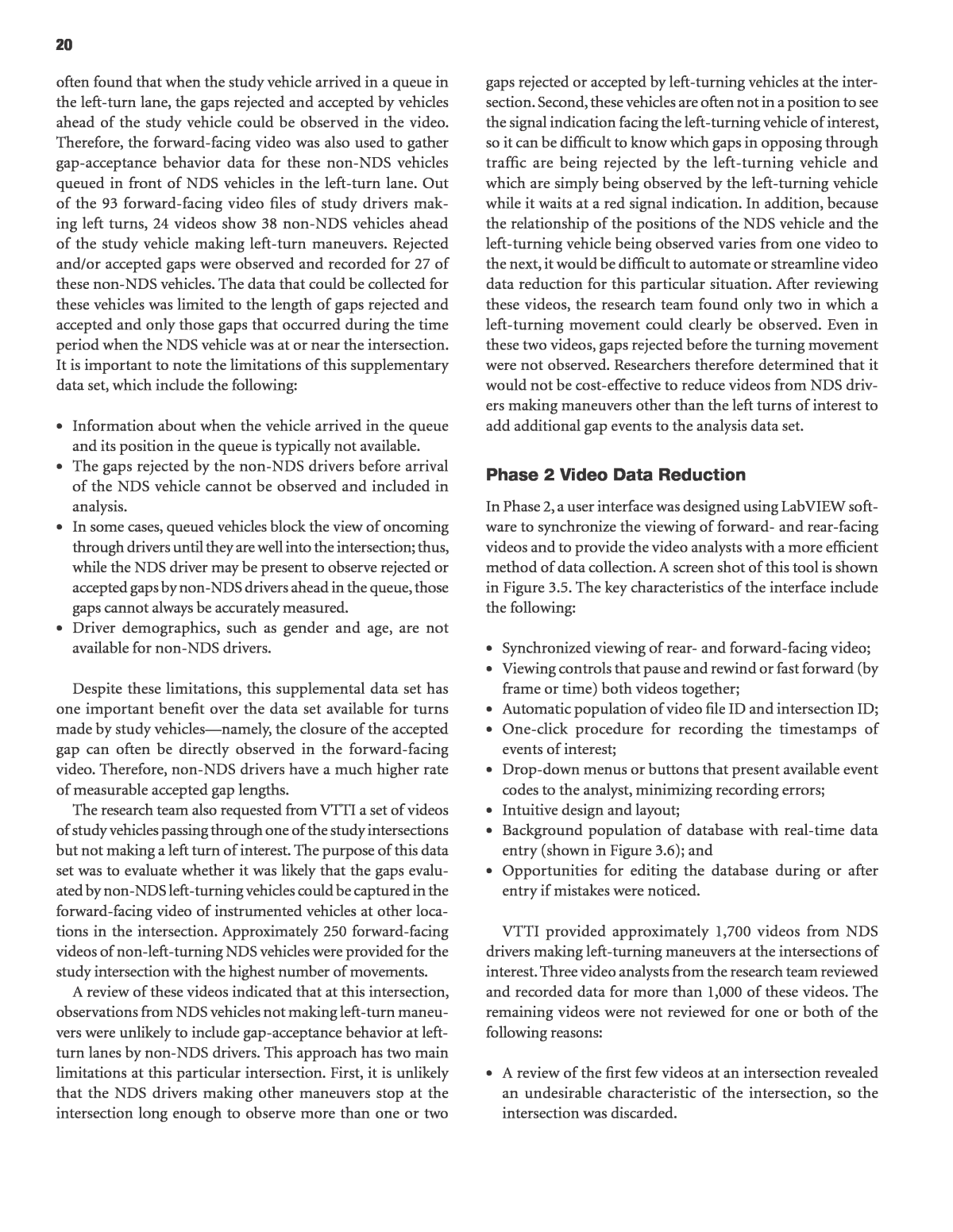
20 gaps rejected or accepted by left-turning vehicles at the inter- section. Second, these vehicles are often not in a position to see the signal indication facing the left-turning vehicle of interest, so it can be difficult to know which gaps in opposing through traffic are being rejected by the left-turning vehicle and which are simply being observed by the left-turning vehicle while it waits at a red signal indication. In addition, because the relationship of the positions of the NDS vehicle and the left-turning vehicle being observed varies from one video to the next, it would be difficult to automate or streamline video data reduction for this particular situation. After reviewing these videos, the research team found only two in which a left-turning movement could clearly be observed. Even in these two videos, gaps rejected before the turning movement were not observed. Researchers therefore determined that it would not be cost-effective to reduce videos from NDS driv- ers making maneuvers other than the left turns of interest to add additional gap events to the analysis data set. Phase 2 Video Data Reduction In Phase 2, a user interface was designed using LabVIEW soft- ware to synchronize the viewing of forward- and rear-facing videos and to provide the video analysts with a more efficient method of data collection. A screen shot of this tool is shown in Figure 3.5. The key characteristics of the interface include the following: ⢠Synchronized viewing of rear- and forward-facing video; ⢠Viewing controls that pause and rewind or fast forward (by frame or time) both videos together; ⢠Automatic population of video file ID and intersection ID; ⢠One-click procedure for recording the timestamps of events of interest; ⢠Drop-down menus or buttons that present available event codes to the analyst, minimizing recording errors; ⢠Intuitive design and layout; ⢠Background population of database with real-time data entry (shown in Figure 3.6); and ⢠Opportunities for editing the database during or after entry if mistakes were noticed. VTTI provided approximately 1,700 videos from NDS drivers making left-turning maneuvers at the intersections of interest. Three video analysts from the research team reviewed and recorded data for more than 1,000 of these videos. The remaining videos were not reviewed for one or both of the following reasons: ⢠A review of the first few videos at an intersection revealed an undesirable characteristic of the intersection, so the intersection was discarded. often found that when the study vehicle arrived in a queue in the left-turn lane, the gaps rejected and accepted by vehicles ahead of the study vehicle could be observed in the video. Therefore, the forward-facing video was also used to gather gap-acceptance behavior data for these non-NDS vehicles queued in front of NDS vehicles in the left-turn lane. Out of the 93 forward-facing video files of study drivers mak- ing left turns, 24 videos show 38 non-NDS vehicles ahead of the study vehicle making left-turn maneuvers. Rejected and/or accepted gaps were observed and recorded for 27 of these non-NDS vehicles. The data that could be collected for these vehicles was limited to the length of gaps rejected and accepted and only those gaps that occurred during the time period when the NDS vehicle was at or near the intersection. It is important to note the limitations of this supplementary data set, which include the following: ⢠Information about when the vehicle arrived in the queue and its position in the queue is typically not available. ⢠The gaps rejected by the non-NDS drivers before arrival of the NDS vehicle cannot be observed and included in analysis. ⢠In some cases, queued vehicles block the view of oncoming through drivers until they are well into the intersection; thus, while the NDS driver may be present to observe rejected or accepted gaps by non-NDS drivers ahead in the queue, those gaps cannot always be accurately measured. ⢠Driver demographics, such as gender and age, are not available for non-NDS drivers. Despite these limitations, this supplemental data set has one important benefit over the data set available for turns made by study vehiclesânamely, the closure of the accepted gap can often be directly observed in the forward-facing video. Therefore, non-NDS drivers have a much higher rate of measurable accepted gap lengths. The research team also requested from VTTI a set of videos of study vehicles passing through one of the study intersections but not making a left turn of interest. The purpose of this data set was to evaluate whether it was likely that the gaps evalu- ated by non-NDS left-turning vehicles could be captured in the forward-facing video of instrumented vehicles at other loca- tions in the intersection. Approximately 250 forward-facing videos of non-left-turning NDS vehicles were provided for the study intersection with the highest number of movements. A review of these videos indicated that at this intersection, observations from NDS vehicles not making left-turn maneu- vers were unlikely to include gap-acceptance behavior at left- turn lanes by non-NDS drivers. This approach has two main limitations at this particular intersection. First, it is unlikely that the NDS drivers making other maneuvers stop at the intersection long enough to observe more than one or two
21 Figure 3.5. Video data reduction user interface. Figure 3.6. Population of Excel database as data are entered in user interface.
22 It should be noted that few pedestrians were observed in any of the videos, so variables related to the presence of pedes- trians were not included. In one instance, a crossing pedes- trian caused a left-turning driver to slow during the turning maneuver and this was recorded as an avoidance maneuver. It is discussed in the near-crash analysis in Chapter 4. In addition, flashing yellow arrows were not used as a permis- sive signal indication at any of the intersections included in the analysis, so while this option was available to the research team, no data are available for consideration of this signal type in the analysis. Variables that were not directly recorded but instead calcu- lated from the recorded data included the following: ⢠Gap length. The end gap time minus the start gap time. Note that this variable could have a negative value in instances when the driver turned left on a red signal indi- cation. The negative value indicates that the available gap actually ended before the driver had the opportunity to turn. These instances were rare. ⢠Time spent waiting for a gap. The time when turn begins minus the time the turning vehicle arrived in the queue. Note that this measure is only available for NDS vehicles and not any other vehicles observed in the video, since arrival in the queue was only recorded for the NDS vehicle. ⢠Postencroachment time. The time between the start of turn and the time the next opposing vehicle reached the stop bar on its approach to the intersection. Note that the post- encroachment time measurements in this study are slightly differently than the measurement of postencroachment time described in the literature because of limitations of what can be viewed in the NDS videos. The measure is designed to closely approximate that described in the lit- erature. This issue is addressed in more detail in the discus- sion of surrogate safety measures in the next section. The research team conducted several rounds of testing of the data reduction interface tool. The first round of testing involved all three video data analysts and focused on find- ing ways to improve the features of the data reduction tool to minimize workload and ensure that all relevant informa- tion is captured. After the tool was updated in response to the findings, each of the three reviewers independently reviewed 10 videosâfive at unsignalized intersections and five at sig- nalized intersections. Discrepancies in the recorded observa- tions were then informally evaluated. In this round of testing, differences in measurements of timestamp variables ranged from close to zero to nearly 1.5 s. The areas in which judg- ment played a role in determining the time of an event or the position of the vehicle were evaluated. This led to the devel- opment of a clearer protocol to better standardize the mea- sures. The three video reviewers then each independently ⢠A substantial number of videos for the same offset cat- egory had already been reviewed, so remaining videos in that offset were considered a lower priority. Each video took 2â20 minutes to reduce, depending on the clarity of the video, the number of gaps that were observed, and the number of non-NDS vehicles in the video for which data could be recorded. On average, each video analyst could reduce approximately six to 10 videos per hour. Variables Reduced from Video Data Table 3.2 lists the variables that were collected using the video data reduction interface and provides a brief description of the coding options available to the video analyst. In general, video-level variables were those that were relevant to every event recorded in the video, such as video and intersection ID, weather condition, and lighting condition. Some video- level variables applied only to events relevant to the NDS driver, such as the time when the driver arrived in the queue (since this typically could not be observed for non-NDS driv- ers). Event-level variables were those recorded for each gap for which data were recorded, including both rejected and accepted gaps being judged by either an NDS or non-NDS driver. The extent to which non-NDS gaps were recorded was a function of how many gaps had characteristics clearly vis- ible in the NDS forward- and rear-facing cameras. Rejected and accepted gap lengths and the presence of an opposing left-turning vehicle creating a sight restriction for the turning driver were the most critical variables to be recorded for the analysis. However, many additional variables were collected to allow the research team to consider other factors that may influence gap-acceptance behavior. Such considerations included the following: ⢠Position in queue; ⢠Total time the NDS driver spent waiting for an acceptable gap; ⢠Presence of a following turning vehicle (which may pres- sure the turning driver to take a smaller gap); ⢠Presence of an opposing right-turning vehicle during a gap that may cause a driver to hesitate to accept a gap; ⢠Type of oncoming vehicle (passenger car or heavy truck); ⢠Light condition; ⢠Weather condition; ⢠Time between beginning of turning maneuver and end of gap, referred to as postencroachment time (the post- encroachment time is the best available approximation of the accepted lagâthe portion the accepted gap remaining after the turning maneuver); ⢠Signal information (when signal turns green, signal indica- tion at start of gap, signal information at start of turn); and ⢠Collision-avoidance maneuvers observed.
23 Table 3.2. Variables Recorded During Video Reduction Variable Definition/Options Video-Level Variables Video ID Automatically recorded when video is selected Intersection ID Automatically recorded from video folder name Light condition Drop-down list: light, dawn/dusk, dark with street lights, dark without street lights Weather condition Drop-down list: dry, rain, snow Arrives in queue Timestamp: recorded when vehicle reaches rear of queue or stop bar if no queue exists Number of vehicles in queue Drop-down list: integers 0â7 and â8 or moreâ Time when rear not visible Timestamp: recorded when reviewer can no longer discern through vehicles passing through the intersection in the rear-facing video No visibility in rear view Check box: checked if this condition applies Time light turns green Timestamp: if signal is red at NDS time of arrival in queue, recorded at time when signal turns green Final gap estimated long Check box: checked if this condition applies (no oncoming vehicles visible in field of view of driver) Notes Text box Event-Level Variables Event number Automatic consecutive numbering for each observed event (gap) Start gap time Timestamp: recorded at the time of each new start of gap or lag End gap time Timestamp: recorded at the time the next approaching through vehicle arrives at the intersection, or at the time the left-turn signal turns red (whichever occurs first) Turning vehicle number Drop-down list: integers 1â5 and âNDSâ (non-NDS vehicles numbered consecutively) Vehicle position Drop-down list: behind/at stop bar, ahead of stop bar, positioned to turn, driver never pauses (recorded at gap start time) LT signal at start of gap Drop-down list: green arrow, green ball, red, yellow ball, yellow flashing arrow Time begins turn Timestamp: recorded at the time vehicle is both accelerating and oriented toward left turn (no longer facing straight ahead) LT signal at turn initiation Drop-down list: green arrow, green ball, red, yellow ball, yellow flashing arrow Avoidance maneuver Drop-down list: none, turning driver, opposing driver, both Type oncoming vehicle Drop-down list: passenger car, heavy vehicle Vehicle behind? Yes/No (yes when vehicle is present behind turning driver) Driver move? Yes/No (yes when vehicle moves forward during gap) Opposing queued Yes/No (yes when opposing through vehicles were queued before proceeding through the inter- section) RT present Yes/No (yes when opposing vehicle turns right during gap) Opposing left present Yes/No (yes when a vehicle is present in the opposing left-turn lane) Sight distance blocked Yes/No (yes when driverâs view of oncoming traffic is restricted by opposing left-turning vehicles) Gap accepted? Yes/No
24 accepted by the NDS driver, the gap end time is the time at which the next opposing through vehicle can be seen enter- ing the intersection in the rear camera view. ⢠Vehicle position. 4 Vehicle position at start of gap (behind stop bar, ahead of stop bar, positioned to turn). 4 If vehicle never stops and accepts first lag, recorded as âdid not pause.â ⢠Turn begins. The time during the turn movement (accepted gap) when the subject vehicleâs angle is oriented toward the left turn and has begun moving forward into a completed turn. ⢠Time when rear view not visible. The point at which the reviewer can no longer be certain that he or she would be able to see an opposing through vehicle pass in the rear- facing video. ⢠Driver moves. Marked as âyesâ if vehicle moves forward for better turn positioning, whether or not gap is accepted. ⢠Avoidance maneuver. Marked if any vehicle makes a sud- den stop, quickly accelerates, abruptly abandons a turning maneuver, or swerves to avoid a collision. Whether the eva- sive maneuver was made by the turning driver, the oncoming through driver, or both drivers is also indicated. ⢠Sight distance blocked by opposing left-turn vehicle. Indica- tion of whether the presence of the left-turn vehicle actu- ally blocks the driverâs view of oncoming traffic from the perspective of the driver. This is an additional measure to the offset to isolate left-turning behavior during periods of limited sight distance. Gap Acceptance as a Safety Surrogate The surrogate measures that most closely describe crash risk-taking behavior by left-turning drivers for intersections with different offsets between opposing left-turn lanes are the durations of gaps accepted and rejected by left-turning drivers at intersections of various design types. A gap is the time headway between successive vehicles, defined as the time between arrivals of the front bumper of successive vehicles at a common point, such as the center of an intersection. When a vehicle is waiting to make a left turn, each gap in oppos- ing through traffic is either accepted or rejected by the left- turning driver. The basic data for a study of this type are the duration of each available gap and an indication of its acceptance or rejec- tion by the left-turning driver. The durations of accepted gaps represent crash risks judged acceptable by the left-turning driver. The durations of rejected gaps represent crash risks judged unacceptable by the left-turning driver. The distribution of the accepted and rejected gap dura- tions is then analyzed to establish the critical gap (tc) at reviewed 10 more videos and once again evaluated discrep- ancies. Timestamp variables (such as gap start and end time and time turn is initiated) fell within approximately a half second for all three video reviewers, showing that the more detailed protocol improved precision. Some variables included in the data reduction procedure are fairly self-explanatory, and the video data reviewers agreed that formal definitions were not required. Other vari- ables include a certain amount of judgment, so formal defini- tions were developed to help minimize the variance among observations from different reviewers. The data collection protocol for these variables was as follows: ⢠Arrives in queue. The time when a vehicle comes to a stop or substantially slows behind other left-turning vehicles; or, if no queue exists, the time when the vehicle crosses the stop bar or its equivalent (if no stop bar exists); or the time when the vehicle stops to wait for gaps if this location is before the stop bar or its equivalent. ⢠Gap start time. 4 For the first recorded gap, the gap start time is recorded when âªâª The front of the vehicle crosses the stop bar (signal- ized intersections). âªâª The front of the vehicle is even with the median nose or the end of the solid lane line to the right of the turning vehicle (unsignalized intersections). âªâª The vehicle comes to a stop if stopped before the stop bar. âªâª If the light is red at time the vehicle arrives in the queue, the front of the first opposing vehicle crosses the opposing stop bar; or, if already ahead of stop bar, when first vehicle begins forward movement. (In this case, opposing vehicles are marked as âqueued.â) Note that the time when the light turns from red to green is also recorded. 4 For other gaps, the gap start time is recorded when âªâª The front of the opposing vehicle passes the stop bar (signalized intersections). âªâª The front of the opposing vehicle passes the median nose or the end of the solid lane line to the right of the turning vehicle (unsignalized intersections). âªâª If driver takes the same gap as preceding vehicle, the preceding vehicle has cleared the intersection (i.e., rear of preceding vehicle has exited far lane of traffic). Note that âtime turn initiatedâ will often be before this gap start time when vehicles follow closely. ⢠Gap end time. The time at which the next gap begins (when the opposing vehicle crosses the stop bar). When multiple vehicles accept the same gap, their gap start times will be dif- ferent, but their gap end times will be the same. For the gap
25 determine when the turning vehicle is in a certain posi- tion. Timestamp data must be recorded at points that are fairly easy to identify in the video, such as at a stop bar, rather than at positions that are not physically marked but might be calculated in a fixed-camera study, such as the center of the intersection or the conflict point. A higher degree of variability between reviewers is noticed for vari- ables that depend on points not clearly marked on the pavement, such as where the turning vehicle has cleared in the intersection. 3. Because the evaluation includes turns at so many inter- sections, the ârulesâ for determining when a vehicle has reached a certain location necessarily change from inter- section to intersection. Identifying a visual cue to help determine when a vehicle has reached a certain point (such as an imaginary line drawn from the end of the solid lane line to the tip of the median) at one inter section approach is not helpful for the analysis of any other inter- section approach. New visual cues must be identified for each intersection approach. In addition, the camera view is a moving frame of reference. These limitations are why automated video data reduction (using machine vision, for example) was not considered feasible for this study. 4. Light conditions play a significant role in the quality of the video data and how well certain elements in the video (lane lines, signal indications, type of approaching vehi- cle, etc.) can be seen. In addition, videos were sometimes poorly focused, making data review more difficult. In Phase 1 of the project, the potential differences in inter- pretation of variables between video data reviewers were not apparent because only one staff member reviewed the video data. In addition, such a limited number of intersections were available for review at the time that the difference between what can be seen at one intersection and another was not as obvious. Despite these limitations, there are several advantages to using the NDS data for this study. The advantages of using the NDS data over a fixed-camera study include the ability to incorporate information about the driverâs age, gender, and other characteristics into the analysis and the ability to evaluate behavior at a wide range of locations with sub- stantially fewer time and cost resources. The NDS data also provide an advantage over the use of crash history data to evaluate safety by allowing researchers to see near misses, avoidance maneuvers, and safety surrogates that are much more frequent than crashes. Compared with studies using driving simulators, the NDS data have the obvious advan- tage of recording truly naturalistic behaviors that occur in real-life scenarios. which gaps are equally likely to be accepted or rejected. This can also be accomplished by determining t50, the 50th-percentile gap (or the gap that is equally likely to be accepted and rejected). Another variable used as a surrogate for crash risk is post- encroachment time. In the literature, this variable is defined as the time between when the turning driver passes the conflict point and when the next opposing through vehicle arrives at that point (Gettman and Head 2003). In the data reduction process, it was difficult to determine the time at which driv- ers reached this conflict point, so measurements were instead taken at the respective stop bars for each vehicle group, which were more clearly defined locations in the videos. Therefore, the definition of postencroachment time used in this research was the time between the start of the turn, which presum- ably occurred somewhere in advance of the conflict point, and the time the next opposing vehicle reached the stop bar on its approach to the intersection. This is a rough approxi- mate of the postencroachment time but is considered to be an appropriate substitute for this research. The approach taken to assess the effect of offset distance on those risk measures is discussed in Chapter 4. Limitations to NDS Video Data Reduction Limitations to using the NDS video data for this analysis include the following: 1. Accepted gaps make up only a small portion of total observed gaps (most drivers reject several gaps before accepting one), so it is critical to be able to measure the length of as many accepted gaps as possible. The primary method of gathering this data element for NDS vehicles is watching for the next opposing through vehicle to pass through the intersection in the rear-facing camera of the study vehicle after the study vehicle completes its left turn. In some cases, a gap-closing vehicle is not visible in the rear-facing camera for one of several reasons, including poor quality or angle of rear camera images, dark condi- tions, intersection approach geometry that limits the vis- ibility of the intersection as the vehicle departs from the intersection, change in signal indication before the next opposing through vehicle arrives, no gap-closing vehi- cle present, or another vehicle follows the study vehicle through the left turn and blocks the rear-facing cameraâs view of the intersection. Thus, nearly half the accepted gaps observed in the videos have no measured length. In many of these cases, the end of the gap would have been more easily visible in a fixed-camera study. 2. Because the view is from the driverâs perspective and not an elevated fixed-camera location, it can be difficult to
26 ⢠Timestamp associated with each row of data collected; ⢠File ID; ⢠Associated video ID; ⢠Alcohol indicator; and ⢠Lighting indicator. The research team did not use these variables in the analy- sis, since all relevant information for the analysis could be obtained from the video reduction. In addition, for each video provided by VTTI, the research team requested demographic information about the NDS driver making the left turn in the video, including age, gen- der, and vehicle type. This demographic information was not available or recorded for non-NDS drivers. The difference in gap-acceptance behavior between men and women, and between age groups, was evaluated for NDS drivers. time-Series Data and Demographics Time-series data associated with each video were requested from VTTI. Variables were recorded at regular time intervals on the trip, including the following: ⢠Heading; ⢠Latitude; ⢠Longitude; ⢠Speed; ⢠Acceleration; ⢠Month; ⢠Year; ⢠Day of week; ⢠Time of day (binned);
