


Below is the uncorrected machine-read text of this chapter, intended to provide our own search engines and external engines with highly rich, chapter-representative searchable text of each book. Because it is UNCORRECTED material, please consider the following text as a useful but insufficient proxy for the authoritative book pages.
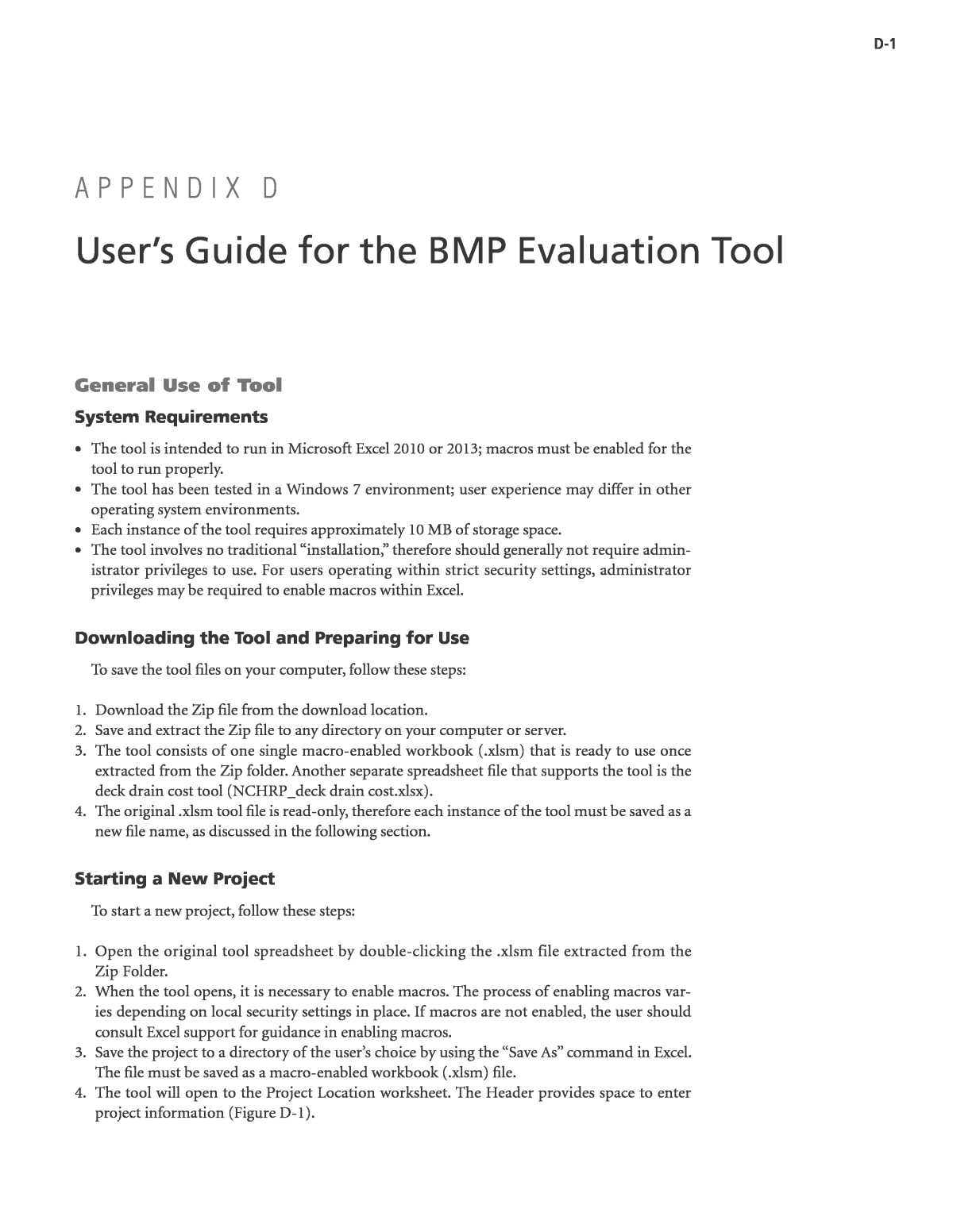
D-1 General Use of Tool System Requirements ⢠The tool is intended to run in Microsoft Excel 2010 or 2013; macros must be enabled for the tool to run properly. ⢠The tool has been tested in a Windows 7 environment; user experience may differ in other operating system environments. ⢠Each instance of the tool requires approximately 10 MB of storage space. ⢠The tool involves no traditional âinstallation,â therefore should generally not require admin- istrator privileges to use. For users operating within strict security settings, administrator privileges may be required to enable macros within Excel. Downloading the Tool and Preparing for Use To save the tool files on your computer, follow these steps: 1. Download the Zip file from the download location. 2. Save and extract the Zip file to any directory on your computer or server. 3. The tool consists of one single macro-enabled workbook (.xlsm) that is ready to use once extracted from the Zip folder. Another separate spreadsheet file that supports the tool is the deck drain cost tool (NCHRP_deck drain cost.xlsx). 4. The original .xlsm tool file is read-only, therefore each instance of the tool must be saved as a new file name, as discussed in the following section. Starting a New Project To start a new project, follow these steps: 1. Open the original tool spreadsheet by double-clicking the .xlsm file extracted from the Zip Folder. 2. When the tool opens, it is necessary to enable macros. The process of enabling macros var- ies depending on local security settings in place. If macros are not enabled, the user should consult Excel support for guidance in enabling macros. 3. Save the project to a directory of the userâs choice by using the âSave Asâ command in Excel. The file must be saved as a macro-enabled workbook (.xlsm) file. 4. The tool will open to the Project Location worksheet. The Header provides space to enter project information (Figure D-1). A P P E N D I X D Userâs Guide for the BMP Evaluation Tool
D-2 5. Once the project information is entered into the heading of the Project Location worksheet, the remaining headings on subsequent worksheets will be updated to match. 6. These steps can be followed for each project/scenario being analyzed with the tool. Organization of the Tool The tool is divided into various input forms that reside on separate worksheets. In some cases, multiple input forms are found on a single worksheet. Primary worksheets have a gray tab color, the capital and maintenance cost worksheets have an orange tab color (hidden), and other miscellaneous tool supporting data have a blue tab color (hidden). Table D-1 summarizes the organization of the input forms and primary worksheets within the tool. Figure D-1. Project information and navigation bar. Navigation Bar Project-specific Information Table D-1. Organization of the tool. Input Form Worksheet Name Summary of User Inputs and Results Project Location and Climate Selection Project Location Specify project location View default climate parameters Override default climate parameters as needed Project Options Project Options View/Edit Pollutant Concentrations Select Primary Cost Inputs Capital Costs (Hidden) Capital Costs Optionally view capital costs sheet and override defaults Maintenance Costs (Hidden) Maintenance Costs Optionally view maintenance costs sheet and override defaults Tributary Area Attributes Project Design Specify tributary area characteristics View reference information related to precipitation and runoff volumes BMP Design Parameters Project Design Specify BMP design parameters View and edit default and additional design parameters Results Summary Report Results Summary Report View summary of performance results in tabular and graphical format Supporting Data Supporting Data View underlying model results data used by the tool to provide performance estimates Whole Life Costs Summary Whole Life Costs Summary View the whole life costs results in tabular and graphical format
D-3 Each input form contains stepwise instructions and a key to the color of cells that appear in the form. Color coding identifies cells as: User Steps Default data; editing allowed with rationale User Entered Data Guidance Lookup Data; do not edit cells Warnings The user is expected to enter data for each âUser Entered Dataâ cell at a minimum, and should review the default and reference values to verify that they are appropriate. Navigating within the Tool The tool provides two options for navigation: ⢠The Navigation Bar that is located below the project information on every page (See Fig- ure D-1) provides hyperlinks to jump to each input form. These buttons can be clicked to move forward or backwards to each input form. ⢠Traditional Excel navigation methods can also be used, including selecting worksheet tabs, scrolling, zooming, and other methods, as the user prefers. Either of these methods can be used, interchangeably, at any point in use of the tool. Saving and Editing Scenarios Each instance of the tool (i.e., each individual .xlsm file) can only represent a single scenario. Multiple scenarios can be run using the following general steps: 1. Open a new instance of the tool 2. Enter inputs to define the first scenario 3. Save this scenario with a distinct file name (e.g., âFileâ â âSave Asâ â âScenarioA1.xlsmâ) 4. Edit inputs to define a new scenario 5. Save this scenario with a distinct file name (e.g., âFileâ â âSave Asâ â âScenarioA2.xlsmâ) 6. And so on for as many scenarios as desired. Files can be organized into directories to help distinguish different analysis scenarios. After scenarios are generated, any of the instances of the tool can be reopened by double-clicking on the selected .xlsm file to view the scenario inputs and results. Printing Summary Results Any sheet within the worksheet can be printed using native Excel print functions. The user can use Excel menus to specify the paper size, printer preferences, and print ranges. By selecting multiple worksheet tables, multiple worksheets can be printed at the same time. Please consult Excel documentation and help files for guidance on printing from Excel. Entering Project Location and Climate Information Selecting a Rain Gage The first step in developing a project scenario is to select the appropriate precipitation gage for your project. A precipitation gage must be selected for values to appear in the Results Summary Report (Figure D-2): 1. Select your projectâs region by clicking on the map. 2. Select your projectâs state by using the drop-down menu under âStates within Selected Region.â
D-4 3. Select the precipitation gage that best represents the project precipitation by using the drop-down menu under âRain Gages Available in State.â Generally, the precipitation gage closest to the project location should be used. Each precipitation gage has associated evapotranspiration (ET) data as well. Providing Site-Specific Precipitation Statistics When a gage is selected, the Tool provides a number of reference statistics related to the gage, including the 85th and 95th percentile, 24-hour storm depths and the average annual precipitation depth. If localized precipitation statistics are available for the project location, these data can be used to improve the estimates provided by the tool. The tool uses the 85th percentile, 24-hour storm depth and the average annual precipitation depth to localize model estimates. To enter site-specific precipitation statistics, overwrite the âProject Locationâ values as called out in Fig- ure D-3. If a new gage is selected, user-entered numbers will be overwritten and must be entered again if still applicable. Note that default and project-specific precipitation statistics are for reference and scaling pur- poses only; they do not imply a BMP size used for performance analysis. The user enters the BMP sizing parameters to be analyzed on the Project Design Worksheet. Entering Project Options Information To begin defining your project and determine the level of detail required, follow these steps to select the project options (Figure D-4): 1. Default highway runoff concentrations have been included to provide an estimate of pollut- ant load reduction. However, if project-specific runoff concentrations exist, then select âyesâ after âWould you like to view/edit the highway runoff concentrations for the project?â 2. If âyesâ is selected, the specific concentrations can then be updated by first changing the âUse Defaultâ column to ânoâ and then entering your own concentration in the âinfluent Figure D-2. Project location and climate selection layout. Map to Select Region State Drop- Down Menu Climate Division and Rain Gage Drop-Down Menu
D-5 concentrationâ column. Note that if you select âyesâ to the default or âyesâ to the question above about editing the defaults, the specific pollutant or all pollutant concentrations will be reset to the default concentration(s), respectively. 3. Enter the Cost inputs to provide site-specific results. The location adjustment factor should reference the RSMeans location adjustment factor and the remaining inputs are specific to each project and location. 4. If you would like to keep the capital and maintenance costs as defaults, then select ânoâ in the âWould you like to view/edit the capital cost inputs?â and âWould you like to view/edit the maintenance cost inputs?â columns, respectively. However, you may choose to enter âyesâ in either cell to edit the default values. Figure D-3. Site-specific precipitation data. 85th percentile, 24-hour storm depths and average annual precipitation depths may be overwritten with site-specific data. Figure D-4. Project options layout. Select to view/edit the default highway runoff concentrations (See Figure D.5) Location-specific User-inputs
D-6 Entering Capital and Maintenance Costs Information If detailed capital and maintenance costs are available, selecting âyesâ to the previous question about editing these costs will unhide two worksheets: âCapital Costsâ and âMaintenance Costs.â If including the cost of a bridge deck conveyance system, the costs would be input under these tabs. Use the following steps to update the cost information: 1. In the âCapital Costsâ worksheet, the default values are provided in green and the blue cells are provided for user input or override. If a user-input value is provided, the costs will reflect this value and if the user-input value is deleted, the cost will then return to the default cost. To reset all user-input capital cost values, click the button âReset to Default values.â Note that all of the user-input values will be deleted. 2. In the âMaintenance Costsâ worksheet, the default values are provided in the âModelâ col- umns, which are based on your previous maintenance costs inputs. However, the blue cells are available to override these values with project-specific information. In the âTotal cost per visit ($)â column, the âuserâ column will calculate the total costs based on the selected user- input values as well as the unchanged default values. In the same column, the âDefault totalâ will simply calculate the total cost based on all default values. Entering Project Design Information Entering Tributary Area Attributes To determine the quantity of runoff that will drain to the BMP in the design scenario, it is necessary to provide certain inputs regarding the tributary area watershed. Follow these steps to provide the necessary tributary area information (Figure D-6): 1. Enter the tributary area (in acres) that represents the entire area that will drain to your BMP. The tributary area should exclude the BMP area itself. 2. Enter the estimate of percent of the tributary area that is impervious (ranging from 0 to 100) which determines the relationship between impervious and pervious area and whether the rainfall will infiltrate or runoff. 3. Select a tributary area soil type from the drop-down menu provided. These soil types have been chosen to represent the typical hydrologic soil groups (A through D). The soil type selected here should be representative of the underlying soil beneath the tributary area. When this soil type is selected, a representative infiltration rate (based on the literature) is also copied into the âunderlying soil infiltration rateâ input for your BMP. However, note that the soil type may vary between the tributary area and the BMP area, and the infiltration rate should be updated to reflect a value that is appropriate within the BMP area. This may occur when different soils are present within the BMP area than the overall tributary area or when Figure D-5. Editing default highway runoff concentrations layout.
D-7 better BMP area infiltration rate data are available, such as that obtained from field testing. It is strongly recommended that default infiltration rate values should be updated with site-specific information whenever available. Entering BMP Design Parameters To begin providing the inputs for your BMP, follow these steps (Figure D-7): 1. The blue cells under the âValueâ column are project-specific and should be updated. The yellow cells also may be project-specific; however, default values have been provided for these parame- ters. If the default parameters do not represent the project design, then they may be overwritten. 2. In addition to the primary design parameters, some BMPs will also have additional param- eters that are shown below the BMP figure. Default parameters are provided for many inputs; however these should be changed to match actual project design configurations, when known, to provide the most accurate results. Figure D-6. Tributary area attributes layout. Tributary area watershed parameters to update These cells are reference values that are calculated based on the user- entered tributary area parameters and the selected precipitation statistics Figure D-7. BMP design parameters input form layout. User-entered primary design parameters Guidance column to help the user select the appropriate inputs for their design Additional design and reference parameters
D-8 Note: Guidance regarding the individual BMP parameters is not provided in this guide. Please refer to the âGuidanceâ and âDefault Valueâ columns located within the Tool that provide guid- ance for each parameter specific to the BMP selected. Viewing and Interpreting Results Viewing Results The âResults Summary Reportâ worksheet is updated based on the scenario that has been inputted in previous forms. It is designed to be printed on a single page to document key inputs as well as results. The Results Summary Report page consists of the following three sections: 1. A summary of your design; 2. A summary of the whole lifecycle cost results; and 3. A tabular and graphical summary of volume and pollutant load performance. The first part of the sheet (Figure D-8) summary section provides a concise description of your BMP design and the key conceptual design parameters. The whole life cycle costs results are summarized to include user-specified inputs such as âassumed level of maintenanceâ and then final results displaying estimated capital and main- tenance costs and 50-year net present value costs. The volume and pollutant load performance results are broken down to display the volumes and loads associated with various treated and untreated flows through the BMP. These volumes and loads are also used to calculate estimated whole water concentrations for each constituent (Figure D-9). Whole Life Costs Summary The whole life costs summary tab provides a more detailed look at the capital and mainte- nance costs associated with the project as displayed in Figure D-10. These detailed costs are broken down to analyze specific costs and they are summarized in graphical format. A further discussion on the development of whole life costs is provided in Appendix E. Viewing Supporting Data The Supporting Data Worksheet provides selected plots showing the continuous simulation model results that are being referenced by the tool to provide the BMP-specific performance results as displayed in Figure D-11. The information on this worksheet is not editable, but is provided for informational and technical documentation purposes only. Figure D-8. Results summary reportâecho of scenario inputs.
D-9 Figure D-9. Volume performance tabular and graphical results. Estimates of whole water concentrations Graphical summary of volume and pollutant results Figure D-10. Whole life costs summary tables.
D-10 Error Messages This tool provides volume reduction estimates by referencing tens of thousands of hydrologic simulations. Because an individual simulation is not being run for each individual project, this tool has some inherent limitations. When providing inputs, the tool interprets them and returns values based on a specific range of data. If the user provided data is outside of this range, the tool will override the user-input with the minimum and maximum values, respectively. In the event that this occurs, the tool will likely be underestimating performance if forced to use the maximum value or overestimating performance if forced to use the minimum value. If the input bounds are exceeded and the minimum or maximum is used, an error message will be displayed for the applicable BMP, similar to that shown in Figure D-12. The user should review the error message and adjust inputs and/or interpret results accordingly. Tool Theoretical Basis and Technical Assumptions This tool is based on a number of technical assumptions. These assumptions are not critical for general use of the tool, however may be relevant for interpreting results and understand- ing the limits of the applicability of the tool. For detailed information about the theoretical basis for the tool and the underlying technical assumptions, see the BMP Evaluation Tool Modeling Methodology (Appendix E) to the Bridge Stormwater Runoff Analysis and Treatment Options guide. Figure D-11. Supporting data modeling results. Figure D-12. Error message (shown in red). Example error message notifying user of input data outside of lookup bounds
D-11 Bridge Deck Drain System Cost Support Tool A separate spreadsheet is provided to aid the practitioner in computing the cost of the deck drain system, if one is needed to convey runoff to the bridge abutment. The capital cost for the conveyance system is added to the estimate computed by the BMP Evaluation Tool by clicking the Project Options tab to reveal the screen shown in Figure D-13: The user should change the blue input field to âyesâ for view/edit of the capital and mainte- nance cost inputs as desired. Note that this guide does not support development of maintenance cost estimates for deck drain conveyance systems. The practitioner should consult with their maintenance division for estimates of the cost of average annual maintenance for the system Figure D-13. Project options.
D-12 being modeled. The detailed capital cost screen in the evaluation tool is shown in Figure D-14, and the field highlighted where the bridge deck conveyance system cost can be entered. Similarly, the maintenance cost for the conveyance system can be entered under the Mainte- nance Cost tab as an âadditional activityâ if desired as shown in Figure D-15. The capital conveyance system cost can be estimated using the spreadsheet provided with this guide (NCHRP_deck drain cost.xlsx). The spreadsheet computes the required deck drain config- uration and capital cost given the bridge geometry. Hydraulics on the bridge deck are computed using Manningâs equation and hydraulics (pipe diameters) of the closed conduits are computed using continuity. Note that the spreadsheet computes the cost for the entire cross section of the bridge (each side of opposing traffic lane area), but only for a constant longitudinal grade. If the bridge includes a sag or crest vertical curve, two computations, one for each side of the high or low point respectively, must be completed. Figure D-16 shows a view of the input and output page of the bridge deck drainage system cost spreadsheet. The input cells are noted by the red oval and shaded in blue. Inputs are: ⢠Bridge length ⢠Bridge width ⢠Longitudinal slope ⢠Cross slope ⢠Shoulder width ⢠Rainfall intensity Input variables are defined in the graphic. Note that although a box-girder type cross section is shown, the tool is applicable for all types of bridges where a CIP drainage system and cast-iron inlets are used. The conveyance cost estimate tool will provide a preliminary cost for pumping Figure D-14. Bridge deck drainage system cost input field.
Figure D-16. Inputs and outputs for the bridge deck drainage system cost estimate tool. Figure D-15. Conveyance maintenance cost input field.
D-14 runoff from the bridge deck if the longitudinal slope will not support a gravity drain system. Note that the pumping cost is provided to aid the practitioner in demonstrating the infeasibility of a pumped system. Pumping runoff from a bridge deck to comply with the requirements of an NPDES Permit is beyond the MEP standard. Cost Analysis Spreadsheet Tool for Bridge Deck Drainage Systems (NCHRP Project 25-42) Introduction The design of any bridge deck drainage systems is based on the FHWA/AASHTO, âHydraulic Engineering Circular No. 21,â (HEC-21) which provides strategies and procedures that guide the designer to obtain (as a final result) a feasible yet cost effective solution for stormwater manage- ment on bridge decks. Properly designed bridge runoff drainage systems provide benefits related to traffic safety, maintenance, structural integrity, and aesthetics. The bridge deck and gutters are surfaces that initially receive precipitation and if the bridge deck grades, super-elevations, and cross-slopes are properly designed, water and debris are effi- ciently conveyed through deck inlets and collector pipes to the bridge end abutment back into the main storm water system (Figures D-17 thorough D-21). Outcome The purpose of this spreadsheet is to allow the user, during the planning stage to determine a relative cost of the drainage system (as a unit cost per square foot of bridge deck) for a constant grade/longitudinal slope and inlets on both sides of the bridge, restricted though, from a conser- vative cost perspective to a sole size inlet opening. For bridge decks with vertical alignments along curves, the user can split the bridge to be analyzed into two parts and determine an average cost. Figure D-17. Bridge deck drainage system components.
D-15 Figure D-18. Bridge deck inlet. Figure D-19. Inlet connection to collector pipe. Figure D-20. Collector pipe.
D-16 Narrative The spreadsheet is subdivided into four main parts: Part 1: InputâBridge Geometry/Rainfall Variables Part 2: Shoulder/Inlet Flow Capacity and Inlets Quantity/Spacing Part 3: Bridge Deck Drainage System Configuration Part 4: Deck Drainage Total Cost/Unit Cost Figure D-21. Collector pipe hanger.
D-17 Part 1: InputâBridge Geometry/Rainfall Variables The user has the flexibility of varying the following input parameters: ⢠Length of bridge ⢠Width of bridge ⢠Width of gutter/shoulder ⢠Deck grade (longitudinal slope) ⢠Deck cross section slope ⢠Rainfall intensity The length of the bridge can be varied from 60 ft to 10,000 ft. The width of the bridge can also be varied from 100 ft to 200 ft. The grade of the deck (longitudinal slope) ranges from 1% to 6% and the cross slope of the bridge typical section can have a varying slope from 2% to 4%. The rainfall intensity is also an input and is established for Manningâs roughness coefficient of 0.016 with a roughness coefficient of 1.0 for bridge decks. The rainfall intensity could vary as an input from 1 in./hour to 9 in./hour. Since the tool is to be used at a planning phase, a required width of gutter (roadway shoulder) will have to be established as a particular essential part of the bridge system reserved for runoff. The user will determine the width of the gutter/shoulder (located on both sides of the bridge) based on the number of travelled lanes and bridge width. This value can be varied from 4 ft to 12 ft. The shoulder width will have the same value on both sides of the bridge. The deck inlets are restricted to one size. Even though theoretically, the size of the inlet could be adjusted, a standard size 1.38 ft wide by 1.38 ft long inlet was chosen to restrict large inlet capacities since the spreadsheet does not allow for inlet capacity reduction due to clogging. The inlet is 1.38 ft deep and has a metal grating with a thickness of 0.1888 ft. Part 2: Shoulder/Inlet Flow Capacity and Inlets Amount/Spacing The next part establishes the total flow capacity of the gutter/shoulder running full. A gut- ter is defined, for purposes of this discussion, as the section of bridge deck next to the barrier/
D-18 sidewalk, that conveys water during a storm runoff event. It may include a portion or all of the shoulder. Gutter cross sections usually have a triangular shape with the barrier/curb forming the near-vertical leg of the triangle. Modification of the Manning equation is necessary for use in computing flow in triangu- lar channels because the hydraulic radius in the equation does not adequately describe the gutter cross section, particularly where the top width of the water surface may be more than 40 times the depth at the curb. To compute gutter flow, the Manning equation is integrated for an increment of width across the section. The flow depth at the edge of the inlet is then calculated based on the cross slope of the bridge section and width of the inlet. The bypassing flow (flow outside the perimeter of the inlet) is then calculated and the intercepted flow is a resultant of the total flow and the bypassing flow. The capacity of the intercepted flow is now established;, however for inlets with a length of 1.38 ft, for runoff velocities larger than 3.6 ft/s, the intercepted flow will not be captured in its entirety due to splash over. The splash over is a function of grate efficiency and can be estimated for higher flow velocities using the following equation which approximates test results. A theoretical length of clear opening is calculated from the depth of the flow at the face of the curb and flow velocity. If the length of clear opening is smaller than the actual inlet width, the intercepted flow is collected fully. If the velocity is exceeded, the capacity of the inlet is reduced as a percentage based on the above equation. Flow not intercepted continues to the next inlet. Finally, the capacity of the inlet could be dictated by the capacity of the 6 in. diameter drain pipe (see equation below) which connects the inlet to the collector system of pipes. If the drain pipe capacity inside diameter is smaller than the intercepted flow, the capacity of the inlet will be controlled by the 6 in. diameter drain pipe.
D-19 The distance from the beginning of bridge to the first inlet is then calculated at a point at which the flow width equals the shoulder width. The spacing of the drains is then a resultant of the flow intercepted and width of bridge. The number of required inlet is the ratio of the distance between the first drain and the end of the bridge to the spacing of the inlets plus one. Part 3: Bridge Deck Drainage System Configuration Since the number of inlets is established, the location (stations along the bridge) of the inlets could be easily determined. The bridge section area is the tributary area of each inlet based on the stationing determined in the previous step. The flow demand in each inlet is determined based on the rational method, and the actual gutter flow required to sustain the determined flow is computed in the next column. The width of the shoulder required should always be smaller than the proposed maximum width of gutter established at the beginning of the spreadsheet. The flow velocity, intercepted flow, and bypass flow are also computed for the actual demands on the inlets using the same methodology used in the first part of the spreadsheet. The flow collected by the inlets will be transferred to the collector pipes as intercepted flow at the inlet plus the bypass flow generated by the previous inlets. The pipe size required for the col- lector pipe system is determined based on the cross sectional area of the pipe and flow velocity. The length of the collector pipes is determined from the inlet stationing and the weight of each pipe segment is determined based on the unit weight for a certain pipe size and pipe length. The collector pipe system is anchored to the bottom of the bridge deck with steel hangers that are spaced at 10 ft OC. The weight of the hangers is determined as a product between an average hanger height. The inlets weight is the weight of a galvanized steel box inlet. Each 6 in. drain pipe segment weight is also accounted being located at each inlet location. The pumping system required inside the bridge is a combination of holding tank, submers- ible pump, backup pump, switches, and other miscellaneous electrical equipment. The cost of the pumping system is determined based on an average unit cost of $10,000 per cfs of runoff flow needed to be pumped. The location along the bridge where pumping station are required is based on a fixed 2% slope for the collection piping system and the available space inside the bridge. Note that pumping system costs are provided for reference only, to assist the practitioner in demonstrating the infeasibility of providing a pumped system to facilitate treatment of bridge deck runoff at the abutment. The whole life costs of a pumping system clearly exceed the MEP standard, and alternative methods for compliance discussed in Chapter 4 of this guide should be considered.
D-20 The cost of each item is determined based on the weight of the item and a unit cost (including 10% contingency) of $6.10/lb of steel. The sum of the cost of the inlets, drain pipes, collector pipes, hangers, and pumping system (if it occurs) is the cost of the runoff drainage system. Part 4: Deck Drainage Total Cost/Unit Cost The cost per square foot of bridge is then determined by simply dividing the total cost of the drainage system by the total area of the bridge.
