


Below is the uncorrected machine-read text of this chapter, intended to provide our own search engines and external engines with highly rich, chapter-representative searchable text of each book. Because it is UNCORRECTED material, please consider the following text as a useful but insufficient proxy for the authoritative book pages.
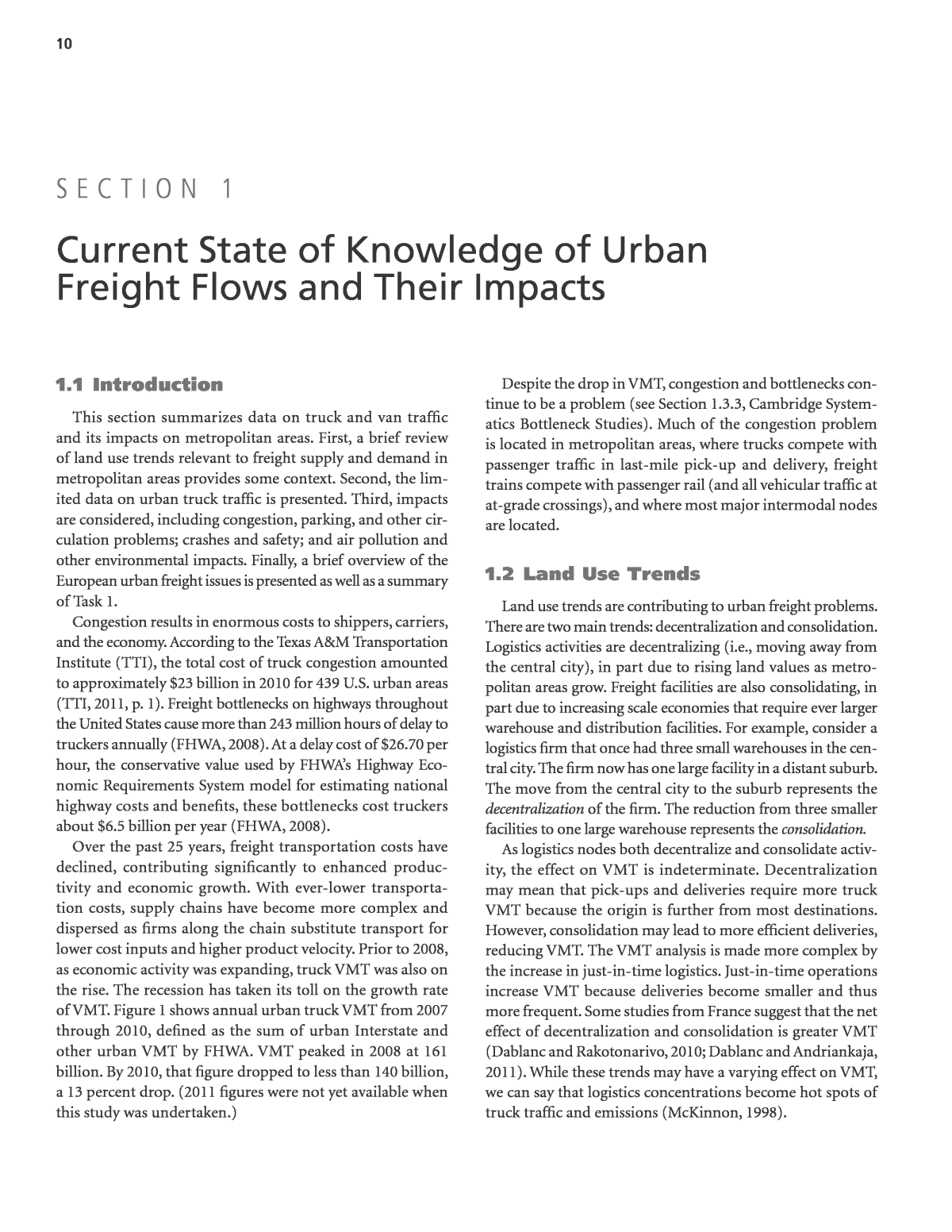
10 1.1 Introduction This section summarizes data on truck and van traffic and its impacts on metropolitan areas. First, a brief review of land use trends relevant to freight supply and demand in metropolitan areas provides some context. Second, the lim- ited data on urban truck traffic is presented. Third, impacts are considered, including congestion, parking, and other cir- culation problems; crashes and safety; and air pollution and other environmental impacts. Finally, a brief overview of the European urban freight issues is presented as well as a summary of Task 1. Congestion results in enormous costs to shippers, carriers, and the economy. According to the Texas A&M Transportation Institute (TTI), the total cost of truck congestion amounted to approximately $23 billion in 2010 for 439 U.S. urban areas (TTI, 2011, p. 1). Freight bottlenecks on highways throughout the United States cause more than 243 million hours of delay to truckers annually (FHWA, 2008). At a delay cost of $26.70 per hour, the conservative value used by FHWAâs Highway Eco- nomic Requirements System model for estimating national highway costs and benefits, these bottlenecks cost truckers about $6.5 billion per year (FHWA, 2008). Over the past 25 years, freight transportation costs have declined, contributing significantly to enhanced produc- tivity and economic growth. With ever-lower transporta- tion costs, supply chains have become more complex and dispersed as firms along the chain substitute transport for lower cost inputs and higher product velocity. Prior to 2008, as economic activity was expanding, truck VMT was also on the rise. The recession has taken its toll on the growth rate of VMT. Figure 1 shows annual urban truck VMT from 2007 through 2010, defined as the sum of urban Interstate and other urban VMT by FHWA. VMT peaked in 2008 at 161 billion. By 2010, that figure dropped to less than 140 billion, a 13 percent drop. (2011 figures were not yet available when this study was undertaken.) Despite the drop in VMT, congestion and bottlenecks con- tinue to be a problem (see Section 1.3.3, Cambridge System- atics Bottleneck Studies). Much of the congestion problem is located in metropolitan areas, where trucks compete with passenger traffic in last-mile pick-up and delivery, freight trains compete with passenger rail (and all vehicular traffic at at-grade crossings), and where most major intermodal nodes are located. 1.2 Land Use Trends Land use trends are contributing to urban freight problems. There are two main trends: decentralization and consolidation. Logistics activities are decentralizing (i.e., moving away from the central city), in part due to rising land values as metro- politan areas grow. Freight facilities are also consolidating, in part due to increasing scale economies that require ever larger warehouse and distribution facilities. For example, consider a logistics firm that once had three small warehouses in the cen- tral city. The firm now has one large facility in a distant suburb. The move from the central city to the suburb represents the decentralization of the firm. The reduction from three smaller facilities to one large warehouse represents the consolidation. As logistics nodes both decentralize and consolidate activ- ity, the effect on VMT is indeterminate. Decentralization may mean that pick-ups and deliveries require more truck VMT because the origin is further from most destinations. However, consolidation may lead to more efficient deliveries, reducing VMT. The VMT analysis is made more complex by the increase in just-in-time logistics. Just-in-time operations increase VMT because deliveries become smaller and thus more frequent. Some studies from France suggest that the net effect of decentralization and consolidation is greater VMT (Dablanc and Rakotonarivo, 2010; Dablanc and Andriankaja, 2011). While these trends may have a varying effect on VMT, we can say that logistics concentrations become hot spots of truck traffic and emissions (McKinnon, 1998). S e c t i o n 1 Current State of Knowledge of Urban Freight Flows and Their Impacts
11 An example of the impacts of economic growth and demand for land on the location of logistics activity can be seen in Atlanta, Georgia. Key freight corridors with access to the Interstate and major arterials are becoming prime space for high-density office and residential or mixed-use develop- ments. These uses bid up prices. As a result, more and more logistics firms are moving their facilities to remote sites just outside of the metropolitan area where land prices are lower. Logistics decentralization is happening all over the United States. Cidell (2010) shows that at the county level in 47 of the 50 largest U.S. metropolitan areas, a decentralization of freight activity occurred between 1986 and 2005, as measured via Gini coefficients. Looking at the zip code level, Dablanc and Ross (2012) have found that in Atlanta between 1998 and 2008, warehouses moved an average of 2.8 miles further away from their geographic centroid. During the same period, all business facilities for all types of activities in Atlanta moved an average of 1.3 miles, i.e., less than half the distance for logistics facilities. A similar trend has been observed in France in the Paris region. Dablanc and Rakotonarivo (2010) calcu- lated that in Paris parcel and express transport companies, on average, locate their terminals 6.8 miles farther away from their geographic centroid today than in 1975, while businesses and shops have only moved 1.8 miles away during the same period. If routing or load economies (from consoli- dation or other factors) do not offset the increased distance between terminals and destinations, deliveries would require more truck miles traveled. A study conducted by Shin and Kawamura (2006) revealed that the majority of national retail chains operate under the same type of supply chain system. Under this type of sup- ply chain system, the companyâs distribution centers are usu- ally quite large, so they must be located far outside city limits where there is ample space to accommodate the buildings (Kawamura and Lu, 2007, p. 34). Delivery trucks must drive many miles to get packages from the distribution center to various parts of the city. Having one main distribution center that is located far from the city center also puts a large num- ber of delivery trucks on the road network in urban areas (Kawamura and Lu, 2007, p. 34). 1.3 Urban Truck Traffic The data on commercial vehicle traffic in urban areas are extremely limited. State departments of transportation are the primary collectors of the existing data on freeways that run through urban areas. State departments of transportation also collect data on the amount of truck traffic on urban arte- rials that are part of the state highway system. The research team was unable to find any data indicating the number of non-truck commercial vehicle trips, i.e., those undertaken in vans, pick-up trucks, or cars or on bicycles. This subsection outlines the data found for trucks on urban freeways followed by a sampling of data found on urban streets designated as state routes. The subsection also discusses some truck bottleneck studies. 1.3.1 National Highway System Data Truck traffic makes up about 10 percent of the VMT on urban Interstates and 7 percent of VMT on other urban road- ways (FHWA, 2011, Table VM-1). In Europe (where cities do Figure 1. Annual urban truck VMTâ2007 to 2010. Note: FHWA changed its methodology in 2007; VMT estimates from prior years are not directly comparable and so were excluded. Source: FHWA (2010, 2008, 2007). 0 20,000 40,000 60,000 80,000 100,000 120,000 140,000 160,000 180,000 2007 2008 2009 2010 M ill io ns o f V M T Heavy Single Unit Trucks Combination Trucks
12 have better truck and van urban traffic data), freight makes up 10 to 15 percent of vehicular traffic in cities, with higher shares observed in the denser core, where automobiles constitute a smaller share of passenger traffic (BESTUFS, 2006). In both the U.S. and Europe, freight transportâs share in city core vehicular traffic is growing for several reasons. First, the urban economy requires more freight movement as inventory holding has declined, the number and variety of goods sold has increased, and express transport services have become a key feature of the way urban businesses operate. Second, large cities tend to attract logistics facilities. Modern supply chains require close proximity to consumer markets and trans-shipment facili- ties in which shipments can be reorganized and goods moved from one truck to another. These requirements are more easily met in large metropolitan areas than in medium-sized cities and rural areas. Third, as noted above, warehouses and distri- bution centers are decentralizing to the periphery of metro- politan areas, which in turn adds to truck VMT. The only source for nationwide truck data in the United States is FHWAâs Highway Statistics Series. This resource provides annual data on truck traffic on the urban portions of the National Highway System (both Interstate and non- Interstate). The research team could find no source that broke out any counts or volumes that focused on commercial vans nationwide. In FHWA parlance, vans are lumped into the light-duty truck category that would include both commer- cial and personal vehicles. One way to see the concentration of truck traffic in U.S. metropolitan areas is to show total long-haul truck volumes on the federal system. In 2007, approximately 39 percent of the miles within the urban segments of the National Highway System Interstate network carried more than 10,000 trucks per day; 40 percent of the network miles carried between 5,000 and 10,000 trucks per day (USDOT, 2011, Table 5-4). The long-haul truck volumes shown in Figure 2 show large areas of concentration in major cities as trucks originate, terminate, or pass through metropolitan areas. The FHWA data are limited in three ways. First, only heavy- duty trucks are included, while smaller trucks and vans make up most of the truck traffic in metropolitan areas. Second, the Figure 2. Average daily long-haul freight truck traffic on the National Highway Systemâ2007. Note: Long-haul freight trucks typically serve locations at least 50 miles apart, excluding trucks that are used in movements by multiple modes and mail. Source: USDOT (2010).
13 data do not include truck traffic on local streets and roads. Third, the data are limited to long-haul trips (i.e., 50+ miles) and exclude intra-city trips. 1.3.2 Municipal Reports Reports on annual average daily traffic volume by state provide data on traffic volume by county. There are few reports on average daily traffic volume by city. Moreover, it is difficult to find reports that categorize traffic volume data by both vehicle classification and road type. One report stated that in Manhattan (NY), â[t]ruck and commercial traffic in turn accounts for 8% of peak period VMTâ (Cambridge Systemat- ics, 2007, p. 3-14). FHWA does request truck share (vehicle classification) data1 to be submitted to its Highway Performance Monitor- ing System (HPMS), but states and cities do not collect these data. In practice, these data are submitted for state highways only and are updated irregularly. Figure 3 shows the percent share of truck traffic on urban roads and highways for four selected counties and one state. (The State of Illinois did not have data available at the county level for truck traffic volume.) In order to show consistent data across all states and counties in Figure 3, the percentages for Los Angeles County, Hennepin County, Fulton County, and New York County were calculated by averaging the per- centage of total truck traffic volume for all types of roads in urban areas. The research team chose these counties because they correspond with major metropolitan cities that have regular freight traffic, and the data were readily available. These percentages reflect an average of traffic volume on both local roads and highways in urban areas and, hence, are only a rough proxy for urban truck traffic. Annual average daily truck traffic volume ranged from about 5 percent to about 10 percent of the total annual average daily traffic volume in 2010 for each of the counties. Figure 4 highlights some urban intersection data from two state reports: Californiaâs and Georgiaâs. There is no par- ticular significance to the intersections presented other than (1) the data were available and (2) the research team was able to confirm that the intersections were in urban areas using Google Maps. Annual average daily truck traffic volume as a percentage of annual average daily total traffic volume at these urban intersections ranged from a low of about 2 per- cent to a high of 6 percent. 1.3.3 Cambridge Systematics Bottleneck Studies Highway interchange bottlenecks affecting trucking are widely distributed across the United States along Inter- state freight corridors of national significance. The urban interchange bottlenecks create sticky nodes that slow intra- regional freight (as well as long-distance truck moves) on urban roadways. According to a 2005 study of freight bottle- necks prepared for the FHWA (Cambridge Systematics, 2005), 11 of the top 25 highway interchange bottlenecks (measured in hours of delay) are either in greater Los Angeles, the location of the nationâs largest maritime port, or Chicago, the nationâs largest intermodal center. 1 Item 81: % Single Unit Trucks in Peak Period; Item 82: % Single Unit Trucks in Average Daily Traffic Flow; Item 83: % Combination Trucks in Peak Period; and Item 84: % Combination Trucks in Average Daily Traffic Flow. Figure 3. Annual average daily truck traffic volume as a percentage of total annual average daily traffic volume for five localesâ2010. Source: Caltrans (2010), pp. 12-13; MDOT (2010), rows 9535-12505, columns AB-AC; GDOT (2010), pp. 6-7; IDOT (2010), p. 34; NYDOT (2011), p. 1. 0% 1% 2% 3% 4% 5% 6% 7% 8% 9% 10% Los Angeles County, CA Hennepin County, MN Fulton County, GA Illinois New York County, NY (Region 11) Location Percent Share
14 An earlier study of the worst physical bottlenecks in the United States (American Highway Users Alliance, 2004) found that 10 of the top 25 bottlenecks were in Los Angeles, Chicago, or Houstonâthe principal gateway to the Gulf of Mexico. The study did not include metropolitan New York City because of its unique geographic nature (bridges and tunnels) and tolling structure for both passenger and freight traffic. Freight congestion problems are most apparent at bottle- necks on highways: specific physical locations on highways that routinely experience congestion and traffic backups because traffic volumes exceed highway capacity. Bottle- necks on highways that serve high volumes of trucks are âfreight bottlenecksâ (Cambridge Systematics, 2005, p. 1-1). They are found on highways serving major international gateways like the Ports of Los Angeles and Long Beach, at major domestic freight hubs like Chicago, and in major urban areas where transcontinental freight lanes intersect congested urban freight routes. Freight bottlenecks are a problem today because they delay large numbers of truck freight shipments. These bottlenecks will become increasingly problematic in the future as the U.S. economy grows and generates more demand for truck freight shipments. If the U.S. economy grows at an annual rate of 2.5 to 3 percent over the next 20 years and the relationship between economic growth and freight remains constant, domestic freight tonnage will almost double and the volume of freight moving through the largest international gateways may triple or quadruple (Cambridge Systematics, 2005, p. 1-1). Without new strategies to increase capacity, congestion at freight bottlenecks on highways may impose an unaccept- ably high cost on the nationâs economy and productivity. 1.4 Congestion, Parking, and Circulation 1.4.1 Truck Parking and Loading/Unloading Zones or Lack Thereof One of the many problems faced by truck drivers making last-mile deliveries is the lack of parking and proper zones for trucks to drop off goods at businesses. The research team found information for two U.S. cities, New York City and San Francisco, related to truck parking. Both metropolitan areas have heavy traffic congestion. At some critical periods of the day, some of this congestion can be attributed to traf- fic caused by trucks making last-mile deliveries to businesses and residences in the city. A case study report on the Midtown area of New York City showed that much of the traffic congestion during peak hours was due to multiple trucks illegally parking in the curbside lane of traffic in order to make deliveries. âThe limited num- ber of loading/unloading zones available, in addition to the number of vehicles using the spaces for long-term parking, has forced many trucks and other large vehicles to double- park, thereby reducing the capacity of the affected street by one lane of trafficâ (Bomar, Becker, and Stollof, 2009a, p. 5). Difficulty in locating available parking space for loading and unloading causes trucks to circle the area several times, which in turn causes increased congestion, air pollution, noise, and fuel consumption (Bomar, Becker, and Stollof, 2009a, p. 9). San Francisco also has commercial vehicle parking prob- lems. Congested loading zones cause commercial drivers to circle looking for a vacant spot or to double park. The San Francisco Municipal Transportation Agency (SFMTA) has developed the SFpark program to increase turnover at Figure 4. Annual average daily truck traffic volume as a percentage of annual average daily total traffic volume for eight intersectionsâ2010. Source: Caltrans (2010); GDOT (2010). 0% 1% 2% 3% 4% 5% 6% 7% Li nc ol n Bl vd a nd Se pu lv ed a Bl vd , L os A ng el es , C A Sa nt a M on ic a Fr ee w ay , L os A ng el es , C A La ke w oo d Bl vd , Lo ng B ea ch , C A A rte sia B lv d, M an ha tta n Be ac h, CA R os w el l R d an d Pe ac ht re e Rd , A tla nt a, G A N or th sid e D r a nd M ar ie tta S t, A tla nt a, G A Fu lto n Co un ty L in e an d Cl ev el an d A ve , A tla nt a, G A Pe ac ht re e Rd a nd Co lli er R d, A tla nt a, G A Intersection Location Percent Share
15 curbside parking spaces including âyellow zones,â i.e., those reserved for commercial loading (Transportation Alterna- tives, 2008, p. 4; SFMTA, 2012). In an attempt to ensure an availability rate of 15 percent of the spaces on a block, San Francisco will vary the price charged for parking. Popular blocks will be priced higher, and blocks with lower demand will be cheaper. If San Francisco is able to hit its availability targets, delivery trucks and vans should have an easier time finding a vacant loading zone. Parking violations and the fees that accrue in attempting to challenge the violations are a major source of revenue loss for most shipping and delivery companies. Parking ticket costs are high for many companies because there are not enough loading zones for trucks delivering goods throughout the city (HolguÃn-Veras et al., 2005, p. 44). 1.4.2 Off-Peak Deliveries Freight delivery in New York Cityâs metropolitan areas causes significant traffic congestion, especially during the day, when delivery vehicles are competing with passenger vehicles (HolguÃn-Veras et al., 2005, p. 44). Many stakehold- ers (i.e., shipping, trucking, and warehousing companies) objected to off-peak deliveries because these companies are constrained by customers who mostly prefer to receive their deliveries during normal business hours. Another challenge for off-peak deliveries is that many businesses cannot afford the staff required to accept deliveries at night. All of those interviewed agreed that receivers were the key to initiating off-peak deliveries because delivery companies cater to the needs of the receivers (HolguÃn-Veras et al., 2005). While HolguÃn-Veras et al. (2005) examined stakeholdersâ perceptions of the idea of utilizing off-peak delivery, Cambridge Systematics modeled the impacts (2007). Cambridge System- atics studied the effects of variable tolls, tax incentives (for receivers staying open at night), shipping cost reductions, and an outright ban on daytime deliveries (Cambridge Systematics, 2007, p. 3-17). The highest peak toll ($7 per axle) combined with the largest tax deduction ($10,000) resulted in a 14 percent shift from daytime to off-peak. Looking at tolls only, Cambridge Sys- tematics predicted that a $2 per-axle toll would lead to a 1.4 per- cent shift and a $7 per-axle toll would yield a 4.2 percent shift. When modeling tax deductions alone, the smallest deduction ($2,000) leads to a 2.1 percent shift, while the largest ($10,000) yields an 8.3 percent change. Results from this work suggest that high tolls and rather substantial tax deductions have only mod- est effects. However, another study from HolguÃn-Veras et al. (2006) shows a higher potential impact of policies on the switch to off-peak hours (see Section 2.1.4.2). Cambridge Systematics also modeled the effects of ship- ping cost reductions (Cambridge Systematics, 2007, p. 3-17). A 20 percent reduction in shipping cost led to a 3 percent shift to off-peak delivery. As the shipping cost reduction increased so did the shift to off-peak deliveries. If shipping costs were entirely eliminated, the model predicted a 13 percent shift to off-peak delivery. In other words, even if shipping costs were zero for receivers, fewer than one in six would shift to off-peak delivery. Excluding the ban, the highest shift modeled was 19 percent; that scenario included the implausible $7 per-axle toll, coupled with 100 percent reduction in shipping costs (Cambridge Systematics, 2007, p. 3-17). Off-peak deliveries are further discussed in Section 2.1.4.2. 1.4.3 Crashes and Safety Few studies have been done recently on crashes involving freight vehicles in urban areas. From 2009 to 2010, there was an 8.7 percent increase in the number of people killed in crashes involving large trucks nationwide (NHTSA, 2011, p. 3). How- ever, this figure does not specify the number of fatalities in urban areas caused by crashes involving large trucks. A study by Retting from 1993 examined fatal crashes involving pedestrians and large trucks in Chicago, Los Ange- les, New York, and Philadelphia for a 5-year period from 1986 to 1990. Retting (1993) found that in these cities 51 percent of large truck involvement occurred at intersections or were intersection related. Non-intersection locations accounted for 44 percent of crash involvement for large trucks; pedes- trian fatalities involving large trucks were almost twice as likely to occur at traffic signals than were crashes involving other vehicle types (49 percent at traffic signals for trucks versus 26 percent for other vehicles) (Retting, 1993, p. 196). Pedestrian fatalities involving large trucks were more than twice as likely to occur between the hours of 9 a.m. and 6 p.m. as those involving other vehicles (74 percent between 9 a.m. and 6 p.m. for trucks versus 36 percent for other vehicles) (Retting, 1993, p. 196). Only 13 percent of large truck crash involvement occurred during hours of darkness, compared with 52 percent for other vehicle types (Retting, 1993, p. 196). Two crash types involving trucks proceeding forward (Crash Types 1 and 2) account for nearly half of all the crashes (Retting, 1993, p. 198). Other crash types include pedestrians struck in the middle of the block, whereâaccording to many of the police reportsâ the truck was emerging from between two parked cars (Retting, 1993, p. 198). Trucks turning at intersections and backing up to pull into a delivery loading zone also caused many pedestrian- involved crashes (Retting, 1993, p. 198). Data on the location of crashes by crash type are provided in Table 2. More recent data on safety incidents involving commercial vehicles and pedestrians are not as specific as the research done by Retting (1993). Loukaitou-Sideris, Liggett, and Sung looked at pedestrian injuries in Los Angeles, but did not break out data by vehicle type, i.e., commercial versus personal (2007). They did find that more pedestrian crashes occur in
16 locations with high concentrations of commercial land uses (Loukaitou-Sideris, Liggett, and Sung, 2007, p. 343); this could imply a correlation between pedestrian fatalities and a larger number of commercial vehicles serving the businesses. However, Loukaitou-Sideris, Liggett, and Sung also found that the number of pedestrian fatalities was lower in areas near industrial areas (2007, p. 343). That could simply be a function of fewer people walking near industrial land uses. Clifton, Burnier, and Akar looked at 4 years (2000â2004) of pedestrianâvehicle crash data in the City of Baltimore (2009). They found that âvans, trucks, and busesâ were slightly less likely than automobiles to be involved in crashes involving the injury of a pedestrian, 46 percent versus 50 percent for cars; however, vans, trucks, and buses were nearly twice as likely to cause death, 2.4 percent versus 1.3 percent for cars (Clifton, Burnier, and Akar, 2009, p. 430). The data presented in Figure 5 from the Fatality Analy- sis Reporting System (FARS) shows statistics on fatal crashes involving large trucks by county. Each of these counties was highlighted because they contain cities that serve as major hubs for freight transportation and are densely populated urban areas. The number of fatalities is represented as a rate per 100,000 population. Both Cook and Los Angeles counties show a downward trend in the rate; rates for the other coun- ties are more mixed. Fulton had the highest rate, although Los Angeles was highest in absolute numbers. Crash Type Intersection Non- intersection Alley Driveway Not in a Roadway Freeway Total Truck proceeding forward, pedestrian at intersection (Crash Type 1) 59 0 0 0 0 0 59 Truck proceeding forward, pedestrian not at intersection (Crash Type 2) 0 32 1 0 0 4 37 Truck turning right, pedestrian struck by rear wheels or trailer (Crash Type 4) 11 2 1 2 0 0 16 Truck turning left, pedestrian struck by front of truck (Crash Type 5) 15 0 0 0 0 0 15 Truck turning right, pedestrian struck by front of truck (Crash Type 3) 13 0 0 0 0 0 13 Truck backing, pedestrian struck (Crash Type 7) 6 3 1 1 2 0 13 Pedestrian walked into side of truck or trailer (Crash Type 9) 2 7 0 1 0 0 10 Truck backing, worker struck (Crash Type 8) 0 5 0 0 2 0 7 Truck turning left, pedestrian struck by rear wheels or trailer (Crash Type 6) 6 0 0 0 0 0 6 Other/Unknown 9 13 3 0 1 0 26 Total 121 62 6 4 5 4 202 Note: totals corrected from the original. Source: Retting (1993), p. 201. Table 2. Fatal truck/pedestrian crashes by type and location.
17 Nationally, large trucks accounted for 5 percent (286,000) of all police-reported motor vehicle traffic crashes in 2009. Of all the motor vehicle traffic fatalities reported, 9.6 per- cent (2,987) involved large trucks (gross vehicle weight rating [GVWR] greater than 10,000 pounds). Of these fatal crashes in 2009, over one-third took place in urban areas (see Table 3). Fatal crashes are twice as likely in rural areas; most urban fatal crashes happen on freeways and principal arterials because that is where trucks travel. 1.5 Environmental Impacts Recent research has shown that fine particulates are asso- ciated with increased incidence of morbidity and mortality from asthma, lung cancer, and other respiratory diseases (Peters, 2004). Heavy-duty diesel trucks are a major source of particulate emissions (Giuliano, Dessouky, and Moore, 2008, p. 182). While there are many sources of emissions in urban areas, freight movement is a major source of nitrogen oxides (NOx) and particulate matter (PM)2. When looking at goods move- ment, the emission inventory will vary both in total size and mode split from region to region. For example, a port city like Houston has more emissions from ships than Detroit even though the two citiesâ total emissions are compara- ble. Tables 4 and 5 show the contributions of NOx and PM103 emissions by mode of freight transport for six metropolitan regions. Note that the tables only include freight transport sources; the contribution of freight to total emissions depends on the characteristics of each region. Within each of the six Source: FARS (2012). 0 0.2 0.4 0.6 0.8 1 1.2 1.4 1.6 Fulton County, GA (Atlanta) New York County, NY Washington D.C. Los Angeles County, CA Cook County, IL (Chicago) Fa ta lit ie s p er 1 00 ,0 00 p op ul at io n 2006 2007 2008 2009 2010 Figure 5. Crash fatalities in which large trucks were involved. Note: A large truck is defined as a truck with a gross vehicle weight rating (GVWR) greater than 10,000 pounds. Source: FMCSA (2011), Table 37. Table 3. Fatal crashes involving large trucks by roadway function classâ2009. 2 NOx are gases and one of the six common air pollutants monitored by the EPA. Nitrogen dioxide (NO2) is the worst NOx. It â[contributes] to the forma- tion of ground-level ozone, and fine particle pollution, [and] NO2 is linked with a number of adverse effects on the respiratory systemâ (EPA 2012a). Particulate matter âis a complex mixture of extremely small particles and liquid droplets. Particle pollution is made up of a number of components, including acids (such as nitrates and sulfates), organic chemicals, metals, and soil or dust particlesâ (EPA 2012b). 3 PM10 designates particulate matter of 10 micrometers or less in diameter. PM2.5 designates particulate matter of 2.5 micrometers or less in diameter.
18 metropolitan areas, trucks were reported to emit the largest amounts of NOx and PM10 emissions. In comparison to other modes of freight transport, trucks are the number one source of pollutants in metropolitan areas that are the most harmful to people. The concentration of freight traffic around intermodal ter- minals or warehouse/distribution centers generates signifi- cant external costs in the form of truck emissions, truck and rail traffic, and noise. These external costs negatively affect residential land values. Thus, the neighborhoods surround- ing such facilities tend to house low-income and/or minority residents, leading to major environmental justice problems. Well-known examples of such neighborhoods include Hunts Point in New York (Lena et al., 2002), Chicagoâs South Side, and the I-710 corridor in Los Angeles (SCAQMD, 2000; Ritz et al., 2006; Peters, 2004). 1.5.1 Los Angeles Region The Los Angeles region is well known for its air pollution problems. Environmental justice problems in the Los Angeles region are particularly well documented as a result of multi- year studies of the impacts of air pollution on children and on the general population (Ritz et al., 2006). Higher rates of asthma and other lung diseases are linked with higher con- centrations of particulates (mainly from diesel fuel) and oxides of sulfur (mainly from ocean vessels). South Coast Air Quality Management District (AQMD) described its Multiple Air Toxics Exposure Study in the South Coast Air Basin (MATES II) as âthe most comprehensive study of urban toxic air pollution ever undertakenâ (SCAQMD, 2000). MATES II covered the parts of Los Angeles, Riverside, and San Bernardino counties on the ocean side of the moun- tains and all of Orange County. The study showed that mobile sources (including passenger and commercial vehicles) gen- erate 90 percent of the cancer-causing air pollutants in South- ern California. The good news was that additional cancer risk attributable to pollution declined 75 percent from the prior decade as Southern Californiaâs air improved. Nonetheless, there was still an average of 1,400 additional cases of cancer per 1 million people as a result of air pollution. That average masks the disparate figures in different areas. MATES II specifically looked at residentsâ exposure to PM gen- erated by burning dieselâmuch of it from commercial vehicles: AQMD calculated the cancer risk of diesel particulate based upon a method for estimating diesel particulate in air samples outlined by the State of California and a cancer potency factor determined by the state. Diesel particulate is emitted by diesel- fueled trucks, buses, trains, ships, tugboats, construction equip- ment, power generators and stationary engines used throughout the region for tasks such as pumping water (SCAQMD, 2000). Trucking Freight Rail Marine Freight Air Freight Freight Total Region NOx (tons) % NOx (tons) % NOx (tons) % NOx (tons) % NOx (tons) % Baltimore 29,081 83% 2,655 8% 3,315 9% 26 0.1% 35,078 100% Chicago 96,291 79% 23,212 19% 2,199 2% 462 0.4% 122,164 100% Dallas-Ft. Worth 53,718 93% 4,157 7% 0 0% 155 0.3% 58,030 100% Detroit 98,195 97% 2,106 2% 468 0% 40 0.0% 100,809 100% Houston 64,590 77% 5,163 6% 14,351 17% 85 0.1% 84,189 100% Los Angeles 130,341 78% 12,744 8% 22,610 14% 870 0.5% 166,564 100% Source: FHWA (2005), Table ES-2. Table 4. Contribution of NOx emissions by mode of freight transport. Trucking Freight Rail Marine Freight Air Freight Freight Total Region PM10 (tons) % PM10 (tons) % PM10 (tons) % PM10 (tons) % PM10 (tons) % Baltimore 734 74% 71 7% 190 19% 1 0.1% 996 100% Chicago 2,641 73% 792 22% 173 5% 10 0.3% 3,616 100% Dallas -Ft. Worth 884 88% 113 11% 0 0% 4 0.4% 1,002 100% Detroit 2,382 96% 58 2% 27 1% 2 0.1% 2,469 100% Houston 1,256 54% 141 6% 915 40% 2 0.1% 2,314 100% Los Angeles 2,210 54% 346 8% 1,521 37% 14 0.3% 4,091 100% Source: FHWA (2005), Table ES-3. Table 5. Contribution of PM10 emissions by mode of freight transport.
19 AQMD found the PM from diesel exhaust âaccounted for 71% of the cancer riskâ (SCAQMD, 2000). AQMD concluded that the primary toxic air pollutant was diesel particulate, and this conclusion led to rules for diesel buses and trucks to clean up their exhaust. Perhaps the most provocative graphic to come out of MATES II, was the so-called âdiesel death zone death mapâ (see Figure 6). This graphic sparked a debate about the effects of urban freight movement in the Los Angeles area. The large banana-shaped dark black section is a corridor that runs from the twin ports of Los Angeles/Long Beach to downtown. The other areas are mostly freeway corridors laden with commercial vehicles. The darker the color, the higher probability of increased cancer risk. The black sections represent areas where the expected excess cancer risk is 1,200 additional cases per 1 million people. The Childrenâs Health Study is an initiative of the Air Resources Board that began in 1992 and was completed in 2004 by researchers at the University of Southern California. The study is a comprehensive and long-term examination of the effects of chronic air pollution exposures on the health of children living in Southern California. Children were chosen as subjects for the study because the effects of air pollution may be more apparent since their lungs and their bodies are still developing. They are also exposed to more air pollution than adults since they breathe faster and spend more time outdoors in strenuous activities. Data were gathered annu- ally from a sample of 6,000 students until they graduated from high school in order to monitor their health, exposures to air pollution, and factors that affected their responses to air pollution. Four pollutants were accounted for in the Note: Number in a million, all sources Source: SCAQMD (2000), c. 5 p. 10, Figure 5-3a. Figure 6. South Coast AQMDâs geographic risk distribution.
20 Hot spots do not just affect people in the surrounding neighborhoods; hot spots also affect truck drivers and ware- house facility workers. Smith et al. (2006) found that drivers who made last-mile deliveries and long-distance deliveries had an elemental carbon/total carbon level that was higher than background levels; this elevated level was also found in dockworkers and hostlers working at each terminal. Truck drivers making last-mile deliveries and pick-ups had a small but significantly higher elemental carbon level than other drivers. 1.5.4 Greenhouse Gas and Carbon Dioxide Emissions Although there is little documentation of the specific effects of freight movement on climate change, a fair amount of research has been done on freight transportation and how much greenhouse gas (GHG) emissions the sector contrib- utes. Carbon dioxide (CO2) is the most commonly known GHG and accounts for approximately 95 percent of total transportation-related GHG emissions (Cambridge System- atics, 2010, p. 2-3). The amount of CO2 released per ton-mile is directly related to the energy consumption of the mode providing that service (Forkenbrock, 1999, p. 516). One gal- lon of diesel fuel releases 22.8 pounds of CO2 (FHWA, 1997, p. I-5, as quoted in Forkenbrock, 1999, p. 516). Freight movement (trucks, ships, trains, airplanes, and pipelines) accounts for 29 percent of the total GHG emissions coming from transportation-related sources; trucks were responsible for emitting 68 percent of GHG coming from these freight sources (Cambridge Systematics, 2010, p. 2-4). Idling is a common occurrence at ports and intermodal stations and on inner city streets due to traffic congestion. Nationally, idling trucks are estimated to consume 20 million barrels of diesel fuel and generate 10 million tons of CO2 annually (Cambridge Systematics, 2010, p. 3-9). For most vehicles, fuel consumption and the rate of CO2 per mile traveled decreases as vehicle operating speed increases, up to an optimal speed. As vehicle speed increases above the optimal speed, fuel consumption and the rate of CO2 per mile traveled begin to increase again. Because of the relationship between vehicle speed and the rate of CO2 per mile traveled, traffic congestion has a great impact on CO2 vehicle emis- sions and fuel efficiency. In real driving conditions, there is a rapid non-linear growth in emissions and fuel consumption as travel speeds fall below 30 mph (Figliozzi, 2010, p. 4). CO2 emissions double on a per mile basis when speed drops from 30 mph to 12.5 mph or when speed drops from 12.5 mph to 5 mph. Frequent changes in speed, i.e., stop-and-go traffic conditions, increase emission rates because fuel consumption is a function not only of speed but also of acceleration rates (Figliozzi, 2010, p. 4). study: ozone, nitrogen dioxide, acid vapor, and PM (Peters, 2004, p. 12). Results from the Childrenâs Health Study indicated that childrenâs lung function growth was adversely affected by air pollution, and new cases of asthma and asthma exacerbations were associated with ambient air pollution levels. Research- ers for the study concluded that current levels of ambient air pollution in Southern California are associated with clinically important chronic health effects that have substantial health and economic impacts (Peters, 2004, p. 271). 1.5.2 New York Region Researchers at Columbia and Harvard Universities con- ducted a study similar to the Childrenâs Health Study in 1999 to assess the effects of air pollution on a group of 46 high school students living in the West Harlem area of New York City. Harlem is at the center of the metropolitan New York region that in recent years has been out of compliance with the National Ambient Air Quality Standards for PM10. Ambi- ent air toxic levels in northern Manhattan and the South Bronx result from region-wide emissions as well as from local sources such as diesel bus depots, waste incinerators, industrial operations at the New York Port, and the net- work of commuter highways, commercial truck routes, and bus routes going through and around these communities. The data for this study were collected from each student in the sample two times over the course of a year. The results from the study in New York demonstrate that young people attending school in inner city New York are exposed to a wide variety of air pollutants. Although exposures to some air tox- ics are clearly driven by indoor sources, exposures to many other pollutants appear to relate more to ambient sources. Urban motor vehicle emissions can be identified as a pri- mary source of harmful air pollution in the area (Kinney et al., 2002, p. 539). 1.5.3 Hot Spots The U.S. government outlines its requirements for studying the potential for new hot spots in Rule 40 CFR 93.123(b)(1). Generally speaking, if a project would increase the number of diesel trucks, it will need to undergo a hot spot analysis. The City and County of San Francisco looked at the issue of hot spots with respect to land use planning (San Francisco, 2007). While San Francisco did not specifically look at com- mercial vehicle traffic as a cause of hot spot creation (for the most part the city lumps cars and trucks together), it did cite a California Air Resources Board recommendation to âavoid siting [residential] land uses within 1,000 feet of a distri- bution center handling more than 100 trucks per dayâ (San Francisco, 2007, p. 13).
21 equipment was the second largest. Other equipment, e.g., rail vehicles, contributed insignificantly to noise at the port. The noise coming from the port was under the regulatory limits associated with each vehicle type (Nguyen and Khoo, 2011, p. 50). There are limited statistical data and little scholarship on noise pollution and its relationship to freight truck traffic in U.S. urban areas (Forkenbrock, 1999; Ross et al., 2011). The most extensive scholarship and research on noise pollution has been conducted in Europe. There, freight transport oper- ations in cities represent 10 to 15 percent of road traffic, but account for 40 percent of air pollution and noise emissions (BESTUFS, 2006). This is a common problem for all European cities even though they have differing geographical, histori- cal, and cultural circumstances. Table 6 provides noise levels associated with the most com- mon urban freight activities, as calculated by the Dutch government (Goevaers, 2011). 1.7 European Focus This subsection looks briefly at urban freight issues in Europe. Surveys conducted in the past decade in several European cities have provided specific urban freight data (BESTUFS, 2006). The Lyon-based Laboratoire dâEconomie des Transports (LET) has calculated that, on average, there is one delivery or pick-up per week per job in larger French cities. In European cities, urban freight transport tends to be more polluting than long-distance freight transport, because of a higher average age of the vehicles and a large number of short trips and stops. Freight transport generates between 20 and 60 percent (depending on the pollutants considered) of local transport-based pollution. As in the United States, NOx and PM are pollutants for which urban freight transport has a particularly important responsibility (Albergel et al., 2006). Urban freight vehicles also tend to be quite old. In Dublin in 2004, a fourth of all vehicles were at least 10 years old. Only 15 percent of the vehicles were new (1 year or less). Emissions from freight sources accounted for 9 percent of overall U.S. GHG emissions in 2006, which is the equivalent of 608 million metric tons of CO2. Second only to air freight, trucking emits 313 grams of CO2 equivalent per ton-mile. This relatively high emissions rate, combined with the fact that trucks are second only to rail in ton-miles of freight moved, explains why trucks are responsible for most freight GHG emissions (Cambridge Systematics, 2010, pp. 2-3, 2-4). 1.6 Noise A significant amount of noise pollution in metropolitan areas is generated by truck traffic. Albergel et al. (2006) calcu- lated that in one French city during the morning peak hours, goods vehicles traffic added 5 dB(A) to the noise emissions coming exclusively from private automobiles. One of the many obstacles to implementing off-peak deliveries in many U.S. cities is the amount of noise that would be produced during evening hours (HolguÃn-Veras et al., 2005, p. 42). Forkenbrock (1999) notes that the composition of the traf- fic is the most important factor in determining the volume of noise. He cites FHWAâs calculation that one combination truck produces as much noise at 55 mph as 28 automobiles (Forkenbrock, 1999, p. 516). A combination truck heard from 50 feet away produces a noise level of 90 dB(A). This level of noise is approximately four times the level emitted by a pick- up truck (Forkenbrock, 1999, p. 517). Forkenbrock uses the FHWAâs noise emission model for heavy trucks to illustrate how the model can be applied to show the effect of significant traffic noise on housing development and value (1999, p. 518). Ross et al. find strong correlations between noise and traf- fic, particularly at night and for medium- and high-frequency noise (2011, pp. 1054â1055). The relationship between noise and pollution was less consistent, although gaseous pollutants were also more strongly correlated with medium- and high-frequency noise, especially at night. These results support the importance of capturing temporally resolved, frequency-specific noise data to better understand commu- nity exposures and health impacts of noise (Ross et al., 2011, pp. 1054â1055). Currently, there are very few studies on the environmental costs of noise pollution caused by freight traffic. In the stud- ies that do exist, the environmental costs of noise are most commonly estimated as the depreciation in the value of resi- dential units alongside the highways. While there are other factors that can cause depreciation in housing values, Berech- man specifies that close proximity to a loud highway or city intersection is most often the defining characteristic of the environmental cost of noise (Berechman, 2009, p. 391). Nguyen and Khoo looked at noise near the Los Angelesâ Long Beach port complex (2011). They found that trucks were the largest cause of noise at the port and cargo-handling Noise Peak level at 7.5 m [dB(A)] Slamming door 74 Driving up/away 67-83 Load hatch 65-92 Containers over load ï¬oor 74-85 Refrigeration kicking in 70-78 Removing on-board forklift 77-82 Shopping trolleys 53-77 Source: Goevaers (2011). Table 6. Freight-related noise levels.
22 In the Milan region, 40 percent of trucks circulating are more than 10 years old (quoted in Dablanc, 2009). Urban freight vehicles tend to be old because many transport companies operating in urban areas are very small, competition among operators is acute, and profit margins are low. Operators save money by buying used trucks or vans and using them as long as possible. GHG emissions and noise pollution are also among the most severe environmental impacts of freight in cities. Freight represents about one-fourth of transport-based CO2 emissions in European cities. There is little information on the congestion impacts of freight in European cities. Another important issue is road safety. Trucks are involved in a small share of the accidents in cities, but the accidents involving them are serious. In 2005, in London, goods vehi- cles accounted for 15 percent of VMT, âbut represented only 7 percent of the total [motorized] vehicles involved in colli- sions that resulted in personal injuriesâ (Transport for Lon- don, 2008a, p. 15). However, goods vehicles accounted for 11.6 percent of total casualties in 2005. The conciliation of truck traffic with bicycle use has been a growing policy target in many European cities following fatal collisions that received a lot of media attention. Trucks have been overwhelmingly (43 percent) involved in bicyclistsâ deaths on Greater London roads between 1992 and 2006 (Morgan et al., 2010). 1.8 Conclusion Large truck VMT in urban areas dropped 13 percent from its peak in 2008 (the research team could find no data on smaller truck or vans so cannot say whether the total VMT for commercial vehicles is up or down). The dip in large truck VMT is most likely a result of the economic recession. As the economy improves, it is expected that VMT will again increase. There are two main trends in logistical facility sitingâ decentralization and consolidation. The effect of these two trends on truck VMT is indeterminate; although some stud- ies have suggested that the net effect is greater VMT. More research is needed. Limited data are available on urban freight vehicles. The research team was able to locate only a few scattered reports as well as some data from urban intersections that happen to be designated as state highways. The team did not find any data counting trips in non-truck commercial vehicles (e.g., vans). This is a critical information gap; understanding the character- istics of urban freight flows requires basic data on commercial vehicles and what they carry. Parking for commercial vehicles is difficult in dense urban areas. The research team highlighted two cities with inno- vative programs: New York and San Francisco. New Yorkâs night-time delivery program is discussed further in Section 2. San Francisco uses variable pricing to encourage turnover and availability in commercial loading zones. Trucks are in relatively few crashes as a percentage of VMT. However, when they are involved in a collision, they often cause greater injury. Trucks are mobile sources of pollution that travel through urban areas. In areas and locations where trucks are con- centrated (e.g., freight corridors, ports, warehouses, etc.), pollution is pronounced and associated with public health problems. Noise and carbon emissions are also associated with freight movement. Both issues are more closely researched in Europe than in the United States. In general, there is more research on urban freight movement and policy interventions in Europe; the latter will be discussed in Section 2. Also in Section 2 we discuss some of the solutions urban areas are employing to address the issues outlined in Section 1.
