


Below is the uncorrected machine-read text of this chapter, intended to provide our own search engines and external engines with highly rich, chapter-representative searchable text of each book. Because it is UNCORRECTED material, please consider the following text as a useful but insufficient proxy for the authoritative book pages.
55 California Senate Bill 375 Goal: Meet regional GHG emissions reductions targets for passenger vehicles Level of analysis: Statewide Methods and/or models used: Regional travel demand models, sketch planning tools, best management practices spread- sheet tool Emissions analyzed: CO2 Summary The State of California has established a goal of achieving 1990 levels of GHG emissions by 2020, and 80% below 1990 levels by 2050, compared with 2005 levels. In 2008 the state developed a Climate Change Scoping Plan (California Air Resources Board 2008b), following the adoption of Assem- bly Bill 32 (AB 32), Californiaâs Global Warming Solutions Act. Out of 18 specific GHG emissions reduction measures in the scoping plan, seven measures were transportation- and land useârelated. One of the measures specifically related to the development of regional GHG targets for passenger vehicles is being implemented under the adop- tion of Senate Bill 375 (SB 375). To implement the new law, SB 375 required the California Air Resources Board (CARB) to develop passenger vehicle GHG emissions reductions tar- gets for 2020 and 2035, in consultation with the stateâs metro- politan planning organizations (MPOs), by September 30, 2010. Through a collaborative process and the appointment of a Regional Targets Advisory Committee, factors and methodologies were considered in the establishment of the targets. As part of the regional transportation planning process, MPOs are required to prepare a sustainable com- munities strategy to reach the regional target provided by CARB. This chapter presents case studies of GHG emissions analysis or policy context that have occurred in recent years in the United States. The analysis covers both highway and transit projects, as well as analyses that were undertaken at the policy or planning level and at the project development level. The case studies presented illustrate a variety of state-level and regional GHG emissions analyses: ⢠California Senate Bill 375: State-level process to develop regional GHG reduction targets for passenger vehicles using regional travel demand models, sketch planning, and best management practices spreadsheet tools; ⢠Maryland Department of Transportation: State-level appli- cation using regional travel demand models, EPA MOVES (Motor Vehicle Emission Simulator) model, and sketch models; ⢠North Jersey Transportation Planning Authority: Regional on-road GHG inventory using regional travel demand model and MOVES; life-cycle assessment using the GREET (Greenhouse Gas, Regulated Emissions and Energy use in Transport) model; ⢠North Jersey Transportation Planning Authority: Regional nonroad GHG inventory using National Emissions Inven- tory, Annual Energy Outlook, and GREET. ⢠Atlanta Regional Commission: Regional land use scenario analysis using travel demand model and emissions factor model; ⢠Hillsborough County, Florida: Regional on-road GHG inventory and long-range plan evaluation using MOVES, regional travel demand model, and Annual Energy Out- look; ⢠New York State Department of Environmental Conservation: Regional and project-level environmental analysis; and ⢠Columbia River Crossing: Regional and project-level multi- modal analysis, sensitivity analyses of key variables, and construction-related emissions analysis. C h a p t e r 5 Case Studies of GHG Emissions Analysis
56 Background Californiaâs Global Warming Solutions Act (AB 32), adopted in 2006, set GHG targets for the state to 1990 levels by 2020 (about a 30% reduction from business-as-usual levels). By the Governorâs Executive Order, further reductions of 80% below 1990 levels by 2050 were called for. To achieve the GHG reduction targets of AB 32, CARB adopted a Climate Change Scoping Plan in 2008. This marked the first comprehensive, multisector program of regulatory and market mechanisms in the United States for achieving designated GHG reductions. For the transportation sector, SB 375, also known as the Sustainable Communities and Cli- mate Protection Act of 2008, was the implementing legisla- tion for regional transportation-related, nontechnology-based GHG emissions reductions. The emissions reduction goals for each of the stateâs 18 MPOs were to be developed in the form of regional targets for passenger vehicles and light trucks for years 2020 and 2035 (California Air Resources Board 2010). Each MPO would be responsible for demon- strating how it would achieve the regional targets provided by CARB through the development of a Sustainable Communi- ties Strategy as part of the regional transportation planning process. Methodology CARB developed proposed regional targets through an exten- sive 18-month process, with the appointment of a 21-member Regional Targets Advisory Committee (RTAC) with repre- sentatives from MPOs; air districts; local governments; trans- portation agencies; homebuilders; environmental, planning, and affordable housing organizations; and the public. A bottom-up approach was taken to estimate the antic- ipated changes and differences among regions using data and analysis developed by the regions. Together, the 18 MPOs represent nearly 98% of the stateâs population and emissions. Due to the uniqueness of each MPO and region, proposed targets were looked at in the following groups: ⢠The four largest MPOs in the Los Angeles, San Francisco Bay Area, San Diego, and Sacramento regions, representing about 82% of the stateâs current population and major source of projected growth; ⢠The eight MPOs in the San Joaquin Valley (Fresno, Kern, San Joaquin Council of Governments, Stanislaus Council of Governments, Tulare, Merced, Kings, and Madera), which have unique challenges with respect to resources and technical capability. They are exploring the potential for collaboration on a multiregional planning process; and ⢠The six remaining MPOs (Tahoe, Shasta, Butte, Mon- terey Bay, San Luis Obispo Council of Governments, and Santa Barbara Association of Governments), which rep- resent a small fraction of the stateâs total population and emissions and are limited in their ability to generate the forecasts and data needed to provide a strong technical basis for setting targets. As a result, CARB proposed tar- gets that reflect current projections in the six MPOsâ most recently adopted regional plans, with a commit- ment to revisit the targets in 2014 when improved mod- eling tools are available. The RTAC process for setting GHG reduction targets under SB 375 was a collaborative effort among the stateâs MPOs and CARB, with support from Caltrans and the California Trans- portation Commission regarding modeling and regional trans- portation plan guidance. RTAC recommended a seven-step process for the target-setting analysis, with the final step being the adoption of targets by CARB in September 2010: ⢠Step 1. Individual MPO analysis of existing regional trans- portation plans; ⢠Step 2. CARB staff analysis of existing regional transporta- tion plan base cases for all MPOs; ⢠Step 3. Preparation of alternative scenarios; ⢠Step 4. Analysis of alternative scenarios by MPOs; ⢠Step 5. CARB staff analysis of MPO alternative scenarios and stakeholder feedback; ⢠Step 6. CARB staff recommendation of draft targets to its board; and ⢠Step 7. Continued technical information exchange and mod- eling of results by CARB, MPOs, and other stakeholders before final target setting by September 2010. RTAC recommended that targets be expressed as a percent- age reduction in per capita GHG emissions from a 2005 base year. These metrics were chosen because they take into account population growth, and 2005 was the most recent year that could be used uniformly for all MPOs. The MPOs prepared an analysis of their adopted fiscally constrained regional transportation plans, including estimates of per cap- ita GHG emissions for the 2005 base year and for years 2020 and 2035. MPO and CARB staffs worked together to ensure consistency in analysis, including use of the following long- range planning assumptions: ⢠Existing and forecasted fuel prices and auto operating costs; ⢠Assumptions about fleet mix and auto fuel efficiency stan- dards provided by CARB; ⢠Updated population forecasts that reflected demographic trends, as well as the results of the recent economic recession; ⢠Adjustments to transportation assumptions to reflect observed transportation operation funding shortfalls between plan adoption and the present;
57 ⢠Assumptions contained within existing regional transpor- tation plans regarding the interaction of goods movementâ related travel demand with that of passenger vehicles; and ⢠Exclusion of external trips (those that begin and end out- side of a region). In preparing alternative scenarios, MPOs considered a variety of GHG reduction strategies related to transportation demand management, transportation systems management, transportation system improvements, land use measures, and pricing measures. Examples of strategies included ⢠Increased transportation funding and system investments in modes that would reduce GHG emissions, such as pub- lic transit, rail transportation, and nonmotorized trans- portation; ⢠Improved integration between land use and transporta- tion policies; ⢠Locating schools in neighborhoods that house the student population or maximize access by alternate modes; ⢠Increased funding for and/or supply of housing affordable to the local workforce; ⢠Promotion of infill, higher densities, mixed uses, improved pedestrian and bicycle connections, and open space preservation; ⢠Increased use of transportation systems management mea- sures that improve system efficiency; ⢠Increased use of transportation demand management measures (e.g., commuter and telework programs and car- pool and vanpool services) to reduce single-occupant vehi- cle travel demand; and ⢠Use of pricing options, such as freeway toll express lanes, dynamic parking pricing, and various fuel taxes or fees. A list of measures, alternative scenarios, and data outputs related to performance indicators were identified for each MPO. Performance indicators included GHG emissions lev- els at target years and performance measures of specified transportation, economic, social equity, housing production, and other environmental issues and concerns. Conclusion Using the data and analysis provided by the MPOs through the RTAC process, CARB proposed per capita GHG reduc- tions for the four largest MPOs, the eight MPOs in the San Joaquin Valley, and the six remaining MPOs. For Californiaâs largest urban areas, CARB proposed per capita GHG reduc- tions of 7% to 8% in 2020, and between 13% and 16% in 2035 through regional land use and nontechnology-based transportation strategies. For the San Joaquin Valley region, CARB proposed per capita GHG reductions of 5% in 2020 and 10% in 2035 (see Table 5.1). CARBâs proposed targets for the six smallest MPOs reflected current projections in their most recently adopted regional plans. When improved mod- eling tools are available in 2014, CARB will revisit the targets for these MPOs. For the 18 MPOs statewide, the proposed targets would result in GHG emissions reductions of over three million metric tons of carbon dioxide (3 MMT CO2) per year in 2020 and 15 MMT CO2 per year in 2035 (see Table 5.2). Achieving the 3-MMT CO2 per year GHG savings in 2020 with the implementation of SB 375 by Californiaâs 18 MPOs would help achieve the nontechnology, transportation- related reductions needed to meet the goals set forth in the AB 32 Scoping Plan (California Air Resources Board 2008a). Figure 5.1 illustrates the various GHG emissions reduction measures outlined in the Scoping Plan and their respective share of the overall state strategy to achieve 1990 emission levels by 2020. Table 5.1. Summary of MPO GHG Reduction Targets Per Capita Group MPO 2020 2035 4 Largest MPOs MTC 7% 15% SANDAG 7% 13% SCAG 8% 13% SACOG 7% 16% 8 San Joaquin Valley MPOs (all 8 MPOs) 5% 10% 6 Smallest MPOs TMPO 7% 6%a SCRTPA 0% 0% BCAG 0% 1% SLOCOG 8% 8% SBCAG 6%a 4%a AMBAG 13%a 14%a a Indicates percentage increase in per capita emissions. Table 5.2. Summary of Resulting GHG Emissions Statewide 18 MPOs 2020 2035 Population 42,234,974 48,341,306 Baseline annual CO2 emissions (MMT CO2/year) 131.8 152.6 Annual CO2 emissions based on proposed target (MMT CO2/year) 128.5 137.5 Change in annual CO2 emissions due to proposed targets (MMT CO2/year) -3.4 -15.1
58 Before MPOs and local jurisdictions adopt a Sustainable Communities Strategy, which will demonstrate how they will achieve the GHG reduction target set by CARB in its Regional Transportation Plan, they will first have to face several chal- lenges, including housing costs, anticipated decreases in sales tax revenues, and sustainable operations and maintenance funding of the current transportation system. CARB staff will continue to work with MPOs and will reassess in 2012 if a target recalibration process will be needed to reflect new data, modeling improvements, or other information in 2014. Maryland Department of Transportation Goal: Implement climate change action plan Level of analysis: Statewide Methods and/or models used: Regional travel demand models, EPA State Inventory Tool (SIT), MOBILE6.2, draft MOVES 2009, sketch models Emissions analyzed: CO2 equivalent (CO2, CH4, N2O) Summary The State of Maryland has established a goal of reducing GHG emissions by 25%, compared with 2006 levels, in 2020. In 2008, the state developed a Climate Action Plan that included eight transportation and land use policy options. The Maryland Department of Transportation (MDOT) was given the lead responsibility to design and implement most of these policies. To develop the policies in more detail, MDOT conducted a baseline inventory of statewide trans- portation GHG emissions for 2006 and 2020 and then ana- lyzed the GHG benefits and costs of a variety of existing, planned, and proposed transportation strategies. The analysis examined vehicle and fuel technology strate- gies, such as federal and state adopted fuel economy stan- dards; regional transportation plans with committed projects; committed emissions reduction measures implemented for air quality purposes; and a set of additional unfunded GHG reduction strategies identified in the 2008 Climate Action Plan and by a coordinating committee led by MDOT consist- ing of state, regional, and local transportation officials. Background In April 2007, Marylandâs governor established the Maryland Commission on Climate Change. The commission was charged with developing a Climate Action Plan that identified the drivers and consequences of climate change, recommended the necessary state preparations, and established benchmarks and timetables for policy implementation. The plan was completed in August 2008. The Climate Action Plan includes a climate impact assess- ment prepared by the Commissionâs Scientific and Technical Working Group. At the planâs core is a suite of 61 policy options developed by a Greenhouse Gas and Carbon Mitiga- tion Working Group and an Adaptation and Response Work- ing Group; 42 of these options focus on ways to mitigate GHG emissions across all sectors. The commission also recommended a state GHG reduc- tion goal of 25% of 2006 GHG levels by 2020. This goal was codified with the passage of the Greenhouse Gas Emissions Reduction Act of 2009, which established deadlines for the development of a statewide GHG inventory and baseline emissions projection, a proposed and final GHG emissions reduction plan, and a progress report by 2015. In 2016, the legislature will determine whether to continue, adjust, or eliminate the requirement to achieve a 25% reduction by 2020 (Maryland Department of the Environment 2009). Of the 42 cross-sector GHG reduction policies, eight are transportation and land use strategies. MDOT was given the lead responsibility to design and implement most of these policies in collaboration with other state agencies, including the Maryland Department of Planning, Maryland Depart- ment of the Environment, and Maryland Insurance Admin- istration. The selected transportation and land use (TLU) policy options are shown in Table 5.3. In January 2009, MDOT began a multiphase work plan to define specific programs, actions, and strategies to address the eight options shown in Table 5.3. Phase I of the work program established a collaborative process comprising seven working groups focused on each policy option (MDOT worked directly Source: California Air Resources Board 2008a. Figure 5.1. California GHG emissions reduction measures for 2020.
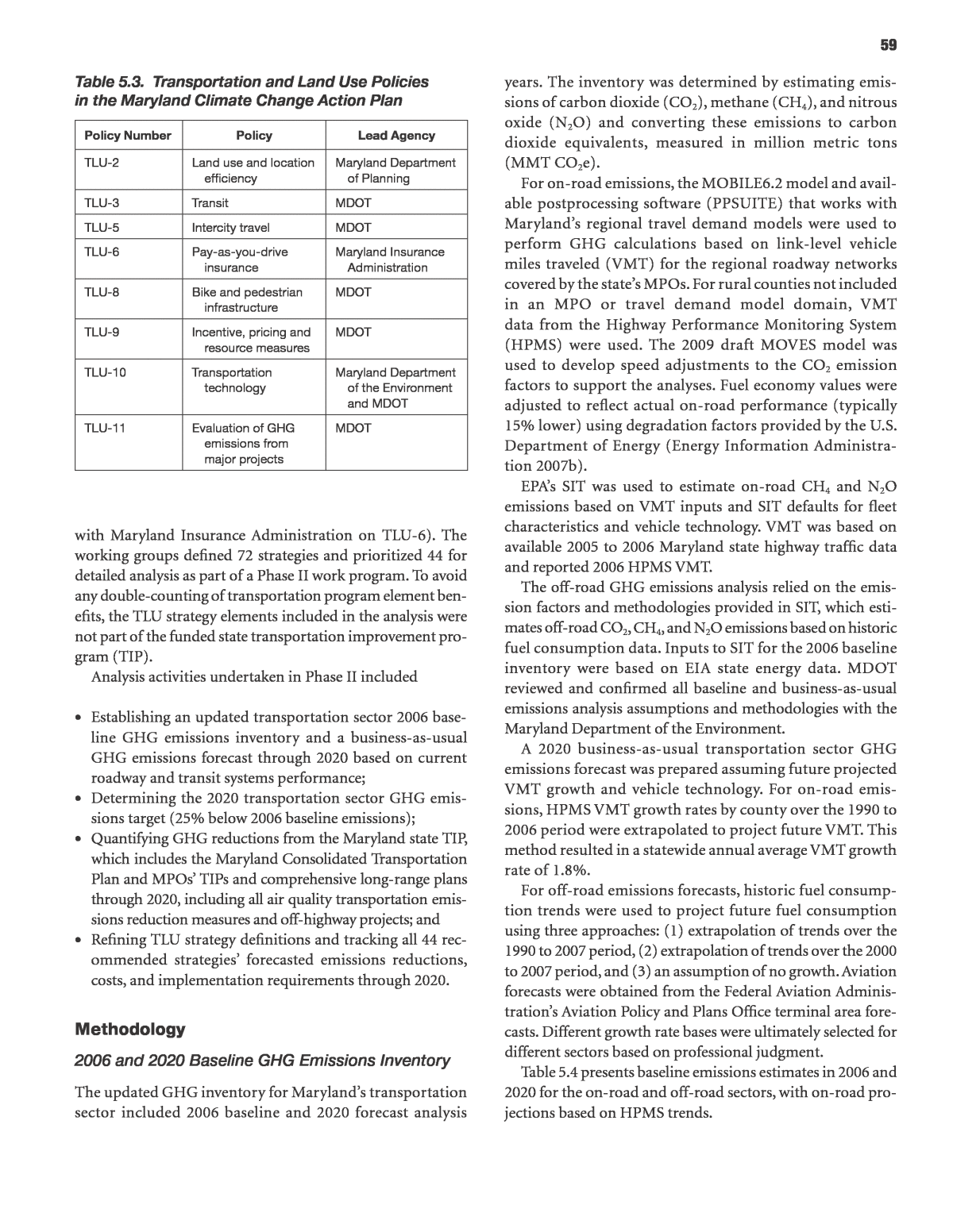
59 years. The inventory was determined by estimating emis- sions of carbon dioxide (CO2), methane (CH4), and nitrous oxide (N2O) and converting these emissions to carbon dioxide equivalents, measured in million metric tons (MMT CO2e). For on-road emissions, the MOBILE6.2 model and avail- able postprocessing software (PPSUITE) that works with Marylandâs regional travel demand models were used to perform GHG calculations based on link-level vehicle miles traveled (VMT) for the regional roadway networks covered by the stateâs MPOs. For rural counties not included in an MPO or travel demand model domain, VMT data from the Highway Performance Monitoring System (HPMS) were used. The 2009 draft MOVES model was used to develop speed adjustments to the CO2 emission factors to support the analyses. Fuel economy values were adjusted to reflect actual on-road performance (typically 15% lower) using degradation factors provided by the U.S. Department of Energy (Energy Information Administra- tion 2007b). EPAâs SIT was used to estimate on-road CH4 and N2O emissions based on VMT inputs and SIT defaults for fleet characteristics and vehicle technology. VMT was based on available 2005 to 2006 Maryland state highway traffic data and reported 2006 HPMS VMT. The off-road GHG emissions analysis relied on the emis- sion factors and methodologies provided in SIT, which esti- mates off-road CO2, CH4, and N2O emissions based on historic fuel consumption data. Inputs to SIT for the 2006 baseline inventory were based on EIA state energy data. MDOT reviewed and confirmed all baseline and business-as-usual emissions analysis assumptions and methodologies with the Maryland Department of the Environment. A 2020 business-as-usual transportation sector GHG emissions forecast was prepared assuming future projected VMT growth and vehicle technology. For on-road emis- sions, HPMS VMT growth rates by county over the 1990 to 2006 period were extrapolated to project future VMT. This method resulted in a statewide annual average VMT growth rate of 1.8%. For off-road emissions forecasts, historic fuel consump- tion trends were used to project future fuel consumption using three approaches: (1) extrapolation of trends over the 1990 to 2007 period, (2) extrapolation of trends over the 2000 to 2007 period, and (3) an assumption of no growth. Aviation forecasts were obtained from the Federal Aviation Adminis- trationâs Aviation Policy and Plans Office terminal area fore- casts. Different growth rate bases were ultimately selected for different sectors based on professional judgment. Table 5.4 presents baseline emissions estimates in 2006 and 2020 for the on-road and off-road sectors, with on-road pro- jections based on HPMS trends. with Maryland Insurance Administration on TLU-6). The working groups defined 72 strategies and prioritized 44 for detailed analysis as part of a Phase II work program. To avoid any double-counting of transportation program element ben- efits, the TLU strategy elements included in the analysis were not part of the funded state transportation improvement pro- gram (TIP). Analysis activities undertaken in Phase II included ⢠Establishing an updated transportation sector 2006 base- line GHG emissions inventory and a business-as-usual GHG emissions forecast through 2020 based on current roadway and transit systems performance; ⢠Determining the 2020 transportation sector GHG emis- sions target (25% below 2006 baseline emissions); ⢠Quantifying GHG reductions from the Maryland state TIP, which includes the Maryland Consolidated Transportation Plan and MPOsâ TIPs and comprehensive long-range plans through 2020, including all air quality transportation emis- sions reduction measures and off-highway projects; and ⢠Refining TLU strategy definitions and tracking all 44 rec- ommended strategiesâ forecasted emissions reductions, costs, and implementation requirements through 2020. Methodology 2006 and 2020 Baseline GHG Emissions Inventory The updated GHG inventory for Marylandâs transportation sector included 2006 baseline and 2020 forecast analysis Table 5.3. Transportation and Land Use Policies in the Maryland Climate Change Action Plan Policy Number Policy Lead Agency TLU-2 Land use and location efficiency Maryland Department of Planning TLU-3 Transit MDOT TLU-5 Intercity travel MDOT TLU-6 Pay-as-you-drive insurance Maryland Insurance Administration TLU-8 Bike and pedestrian infrastructure MDOT TLU-9 Incentive, pricing and resource measures MDOT TLU-10 Transportation technology Maryland Department of the Environment and MDOT TLU-11 Evaluation of GHG emissions from major projects MDOT
60 Strategy Analysis MDOT estimated the GHG emissions reductions and associ- ated costs for the following strategies: ⢠Technology improvements and fuels, ⢠Committed projects in the Consolidated Transportation Plan and MPO TIPs and long-range-plans, ⢠Currently programmed transportation emissions reduc- tion measures, and ⢠Additional transportation and land use strategies identi- fied in the Climate Action Plan. Technology ImprovemenTs and Fuels The technology and fuels improvements strategies included the then-proposed federal fuel economy standards for model years 2011 through 2016; the Maryland Clean Car Program, which incorporates California emissions standards for model years through 2020; and EPAâs then- proposed revisions to the National Renewable Fuel Stan- dard program, which set targets for the total amount of renewable fuels that must be used for transportation fuels each year. The effects of these programs were modeled by adjusting emission rates from MOBILE6.2 to account for fuel economy standards and for reductions in the carbon intensity of fuels. For 2012 to 2016, it was assumed that the average light-duty emission factor in 2016 is 250 g CO2/mile, with a linear phase- in to meet this level between 2012 and 2015 (this phase-in was advanced 1 year to account for earlier implementation consistent with the Maryland Clean Car Program). Between 2017 and 2020, the CO2 estimates are based on targets from the California Air Resources Board analysis of the California Pavley Phase 2 regulation. The renewable fuel standard adjustment was based on an approach used by the Metropolitan Washington Council of Governments, reflecting a 2% reduction in total mobile CO2 emissions in 2030 as a result of using renewable fuels. For this analysis, a 1% overall reduction in 2020 on-road emissions was assumed to result from the implementation of the pro- posed renewable fuel standard. commITTed TransporTaTIon projecTs To account for the impact of planned transportation plans and programs in 2020, available MPO-forecasted travel and land use data were employed to evaluate VMT growth. The growth rates under this scenario incorporated the impacts of future regional demographic projections from each MPO and the impacts of planned highway and transit transporta- tion projects in the regional TIPs and long-range transpor- tation plans. Under this scenario, the average statewide annualized VMT growth rate was 1.4%. This compared with a baseline growth of 1.8% annually based on historic VMT trends from the HPMS. The existing plans and projects were therefore assumed to be equivalent to the difference in the base VMT growth rate (1.8%) versus the model-forecasted 1.4% growth rate. TransporTaTIon emIssIons reducTIon measures The Clean Air Act Amendments of 1990 and the Safe, Accountable, Flexible, Efficient, Transportation Equity Act (SAFETEA-LU) required MPOs and state DOTs to perform air quality analyses to ensure that the transportation plan and program conformed to the state mobile emissions budget established for criteria pollutants. To support air quality attainment, Maryland transportation agencies had identified transportation emissions reduction measures that provide criteria pollutant emissions reduction benefits. These mea- sures have been assessed in conformity documentation that included specific information on the costs and expected air quality benefits. The transportation emissions reduction measures identi- fied in the 2009 to 2014 Consolidated Transportation Plan and the MPOsâ TIPs and long-range transportation plans, as well as the continuation of current programs such as those focused on commute alternatives, incident management, and traffic operations coordination, were assessed to estimate GHG emissions reductions and costs through 2020. Reductions in VMT or fuel consumption as estimated by the Baltimore and Washington MPOs, MDOT, and Maryland Department of the Environment were adjusted to reflect 2020 conditions and converted to GHG emissions reductions using GHG emission factors per mile or per gallon of fuel. For the strategies for which a prior benefits analysis had not been completed, observed data on the benefits of these strategies in other locations or research reports were used to determine potential 2020 benefits. The key methods and assumptions for each type of strat- egy analyzed are shown in Table 5.5. Results As a point of comparison to meet the 25% reduction target, MDOT assessed the benefits of all the reduction strategies Table 5.4. Baseline GHG Emissions for Maryland Source Type CO2e (MMT) 2006 2020 On-road 30.51 34.67 Off-road 3.03 3.10 Total transportation 33.54 37.77 Goal: 25% below 2006 â 25.15
61 compared with a goal of reducing statewide GHG emissions by 12.62 MMT CO2e in 2020. This is equivalent to a 33% reduction in projected statewide GHG emissions from all sec- tors compared with the 2020 baseline. Figure 5.2 shows how the various reduction strategies add up. From its initial forecast growth of 13%, federal and state fuel economy and renewable fuel standards reduced the 2020 GHG forecast by 4.76 MMT, or slightly below 2006 levels. Existing transportation plans and programs, combined with existing emissions reduction measures, reduced projected 2020 emissions by an additional 2.11 MMT, or 9% below 2006 levels. Implementation of the eight unfunded TLU pol- icy options at different levels of deployment creates a range of a 1.62- to 3.16-MMT reduction in 2020, thus accounting for an additional 30% to 60% of the target shortfall. At the high- est level of potential TLU strategy deployment through 2020, plus the benefits of existing statewide transportation sector strategies, the transportation sector was estimated to achieve a reduction of 82% of the 2020 shortfall. In other words, compared with the Climate Action Plan and Maryland GHG Emissions Reduction Act goal of a 25% reduction of 2006 emissions in 2020, the transportation sector could reduce GHG emissions by 20.4% in 2020. The analysis also provided an initial cost estimate (capital investment only) for the TLU strategies of $4,796 to $6,002 million over the existing funded transportation plans and programs through 2020. As a point of reference, the existing funded state capital program in the 2009 to 2014 Consoli- dated Transportation Plan totaled $12,302 million. This potential level of investment represented roughly a 40% to 50% increase in funded transportation system capital invest- ment in the 2009 to 2014 plan. Conclusion This case study examined how one state DOT conducted a GHG baseline inventory and strategy assessment in support of the stateâs Climate Action Plan and legislated GHG reduc- tion targets. The inventory included both emissions from on- road and off-road sources and used available data sources and modeling tools, including regional travel demand models, EPAâs MOBILE6 model, HPMS data, and EPAâs SIT. The Table 5.5. TLU Strategy Analysis Methods Strategy Analysis Methods TLU-2 Land use and location efficiency Data on per capita VMT by census tract density combined with assumptions about population growth in different density ranges. TLU-3 Transit Ridership and service growth needed to reach previously established state goal of doubling 2000 ridership by 2020 compared with extrapolation of existing ridership and service trends (incorporating Baltimore and Washington regional trends and committed projects). TLU-5 Intercity travel Assumed increased transit mode share to BWI Marshall Airport; assumed increased MARC (Maryland-based commuter rail) and Amtrak ridership compared with existing levels as a result of service improvements. TLU-6 Pay-as-you-drive insurance Applied VMT percentage reductions from other PAYD pilot studies to different assumptions regarding percentage of policies covered in Maryland by 2020. TLU-8 Bike and pedestrian infrastructure For trails, compared existing walk and bike mode shares in areas near trails with other areas; assumed greater trail coverage consistent with Maryland Strategic Trail Plan and resulting mode impacts for residents near new trails. For pedestrian infrastructure, applied an elasticity of VMT with respect to a pedestrian environment factor to assumed changes in the pedestrian environment factor as a result of neighborhood pedestrian improvements in business districts and near schools and transit stations; baseline mode shares varied by population density. TLU-9 Incentive, pricing, and resource measures Applied VMT elasticities (change in VMT with respect to change in travel cost) to VMT fees and congestion pricing. EPA COMMUTER model used to assess impact of expanded workplace-based travel demand management programs. TLU-10 Transportation technology Traffic management benefits projected from existing evaluations of the Maryland Coordinated Highways Action Response Team program. Benefits for idle reduction programs, truck fuel economy improvements, and off-road vehicle retrofits projected from various assumptions regarding technology benefits and fleet penetration. TLU-11 Evaluation of GHG emissions from major projects Not applied.
62 assessment accounted for existing and planned federal and state fuel economy and renewable fuel standards, state and regionally programmed transportation projects, and planned air quality emissions reduction measures. Finally, the assess- ment used a variety of sketch methods to estimate the poten- tial GHG emissions reductions and costs of transportation and land use strategies prioritized in the stateâs Climate Action Plan. MDOT and its state and regional partner agencies will continue to consider implementation of the strategies evalu- ated in the plan. This ongoing assessment will include out- reach and coordination activities with the modal agencies, MPOs, other state agencies, and local jurisdictions to build consensus, gain buy-in, and assist in the planning and imple- mentation of the transportation sector climate changeâ related strategies. The Greenhouse Gas Emissions Reduction Act of 2009 requires annual updates to the Maryland Com- mission on Climate Change from each state agency regarding progress in implementing GHG emissions mitigation mea- sures. This includes tracking of the implementation of spe- cific GHG beneficial projects and programs. Also, in 2011 and 2012, as required by the Greenhouse Gas Emissions Reduc- tion Act, MDOT worked with other state agencies to develop a publicly reviewed state implementation plan for meeting the 2020 GHG reduction targets. North Jersey transportation planning authority regional On-road GhG Inventory Goal: To allocate total GHG emissions among sources and serve as a baseline for future projections. Level of analysis: Regional Methods and/or models used: Regional travel demand model, MOVES, GREET Emissions analyzed: CO2 equivalent (CO2, CH4, N2O) Summary The North Jersey Transportation Planning Authority (NJTPA) is the MPO for 6 million people in the 13-county northern New Jersey region. NJTPA has completed a multisectoral GHG emis- sions inventory for the entire NJTPA region. The inventory is intended to allocate total GHG emissions among sources and down to the county and municipal level, as well as to serve as a baseline for future projections. This inventory is designed to help state, regional, and local policy makers and citizens under- stand GHG emissions sources so that well-informed policy decisions can be made to reduce these emissions. The regionwide GHG inventory is part of a larger multi- year climate change initiative at NJTPA that includes mitigation Figure 5.2. GHG emissions scenarios, Maryland.
63 and adaptation research and planning, conducting an inven- tory of climate-vulnerable facilities within the region, and creating a framework for incorporating climate impacts into evaluation criteria for programs and project selection and prioritization. Background NJTPA has developed base year and forecast year GHG emission estimates. The GHG inventory and forecast were conducted for all emissions sectors for the North Jersey region and will be used to inform decision makers con- cerned with mitigation planning across different sectors. This case study focuses on the on-road portion of the over- all GHG analysis; the following case study describes the nonroad GHG emissions inventory for the NJTPA region. The project demonstrates the types of data needs that arise in GHG planning and how data gaps can be addressed. Because NJTPA has its own regional transportation model (the North Jersey Regional Transportation ModelâEnhanced, or NJRTME), this model was used in conjunction with the EPAâs MOVES model to estimate on-road vehicle GHG emissions. Methodology The inventory effort estimated the emissions from all on- road vehicles in the 13-county North Jersey area. Emissions sources included passenger cars and trucks, motorcycles, commercial trucks, heavy-duty vehicles, and buses, fueled by gasoline, diesel, or other alternative fuels. All three major pol- lutants (CO2, CH4, and N2O) were estimated in three catego- ries: direct emissions, consumption-based emissions, and energy-cycle emissions, which included upstream well-to- pump emissions. The direct emissions estimate showed the impacts of emissions within the regionâs borders. The con- sumption estimate represents the emissions from trips that begin and/or end in North Jersey, thus representing emissions that could be controlled by local jurisdictions. The energy- cycle estimate builds on the consumption estimate to provide an idea of total upstream emissions (from fuel refining and transportation) that accompany the North Jersey emissions inventory. Emission factors were estimated using the MOVES 2010 model. Emissions in this analysis were calculated at the level of detail of 13 MOVES source types and the four MOVES road types. The analysis used the base year of 2006 and forecast years of 2020, 2035, and 2050. This range pro- vided an estimate longer than the window for the long- range transportation plan (typically 20 to 30 years). In this case, NJTPA extended its own VMT growth estimates from 2035 to 2050. Direct Emissions The direct emissions associated with on-road transportation included all of the GHG emissions for highway vehicle travel that occur within the geographical boundaries of the NJTPA region, including emissions associated with vehicle starts and stops, and exclude the portion of a tripâs emissions that might occur outside the region. Emissions were presented at the municipal civil division level, which provided information at a subcounty level to assist decision makers at all levels of government. VMT was the primary activity factor used in the emissions calculation for on-road transportation. VMT for the North Jersey region was estimated using NJTPAâs travel demand model, which provided link-based VMT by vehicle type. The estimates were then input into MOVES. Since the travel model provided only an approximation of actual conditions, the traffic volumes produced by the model were adjusted to be consistent with reported HPMS totals. The 2006 HPMS VMT adjustments were applied for both base year (2006) and forecast year estimates. The vehicle types provided by the transportation model were mapped into MOVES source types using an aggregate version of New Jersey vehicle registration data for the NJTPA region. Table 5.6 shows how the NJRTME vehicle types were mapped to the corresponding MOVES source types in this analysis. MOVES inputs included information on meteorology, vehicle age distributions, aggregated motor vehicle registra- tions, fuel properties, and vehicle inspection and mainte- nance program information. These data were provided by the New Jersey Department of Environmental Protection. MOVES runs generated emission rates for each analysis year and each county. To estimate direct emissions, the volumes on each link in the network by source type were applied to the corresponding emission rates from the MOVES lookup data- base. Emissions were then aggregated to the level of the corre- sponding municipality with the data indexed by source type. Consumption-Based Emissions Consumption-based emissions were estimated by munici- pality of origin for each of the four analysis years (2006, 2020, 2035, and 2050). Unlike direct emissions, which were computed for individual highway links and allocated to the municipality in which the link was located, consumption- based emissions were calculated for each origin-to-destination trip in the region, then allocated to the origins and desti- nations that produced and attracted those trips. VMT associated with travel outside the NJTPA region (i.e., Con- necticut and Maryland) was discarded. This consumption estimate provided a different perspective on the regionâs emissions, because trips which neither begin nor end in
64 the North Jersey area are less important to local decision makers. Trip distances for trips within the region were estimated using a traffic analysis zone (TAZ) to TAZ distance table (skim matrix), which was available from the NJTPA travel demand model. The distance between each TAZ pair was estimated based on the shortest path through the congested network as determined via the final iteration of the highway assignment process. Corrections were applied to estimate travel distances for externalâinternal trips, whose distance was estimated from the TAZ to the regionâs boundary line. For each originâdestination pair (6.5 million such pairs in the NJRTME), vehicle hours of travel and speed, vehicle type, road type, and time of day were applied against the MOVES emissions rate lookup table (with MOVES emissions rates calculated as described in the direct emissions section) and multiplied by the appropriate VMT; emissions were then calculated for that originâdestination movement. VMT and emissions were split 50% to the origin TAZ and 50% to the destination TAZ. Finally, TAZ emission and VMT totals were aggregated by municipality and by county. Energy-Cycle Emissions Energy-cycle GHG emissions in the on-road sector are asso- ciated with the production, refining, and transport of motor vehicle fuels. The Argonne National Laboratoryâs GREET model was used to estimate the energy-cycle emissions of all transportation fuels in this analysis. Energy-cycle GHG emissions estimates were developed for on-road vehicles using an estimate of the portion of the fuel consumption for each vehicle type by fuel type. The fuel type was needed because the energy-cycle emission rates for gaso- line, diesel, and ethanol vary. Emissions were not tracked by fuel type in the direct or consumption-based emissions anal- yses. Therefore, a rough method for estimating the portion of fuel consumption by fuel type was developed from the con- sumption emissions analysis. A MOVES run using default data for Bergen County, New Jersey, in 2006 was developed to obtain the output of energy consumption by fuel type and source type. This fuel type breakdown was applied in all analysis years and to the entire NJTPA region. When comparing emissions from fuel combustion (from The Climate Registryâs General Reporting Protocol) with energy-cycle emissions (from the GREET model), energy- cycle emissions for gasoline were 23.0% higher than direct emissions (assuming that gasoline includes 10% corn ethanol by volume), and diesel energy-cycle emissions were 10.8% higher than direct emissions. These energy-cycle emissions estimates were developed using GREET 1.8b emission factors. In order to estimate energy-cycle emissions, the consumption-based GHG estimates were multiplied by the appropriate energy-cycle multiplier, which varied between 11% and 23% depending on the amount of diesel versus gas- oline used. For example, light commercial trucks used (84.7% gasoline à 23.0% increase) + (15.3% diesel à 10.8% increase). This resulted in an estimated increase in energy-cycle emis- sions for all light-duty commercial trucks of 21.2%. These percentages were then applied to the consumption-based emissions to estimate energy-cycle emissions from on-road vehicles. Table 5.6. Transportation Model Vehicle Types Split to Source Types NJRTME Vehicle Type MOVES Source Type Code MOVES Source Type Description Split Auto 11 Motorcycle 3.0% 21 Passenger car 59.8% 31 Passenger truck 37.0% 54 Motor home 0.2% Heavy truck 51 Refuse truck 4.45% 61 Combination short-haul truck 18.95% 62 Combination long-haul truck 76.60% Commercial truck 32 Light commercial truck 100.0% Medium truck 41 Intercity bus 3.0% 43 School bus 42.9% 52 Single unit short-haul truck 50.3% 53 Single unit long-haul truck 3.8% From New Jersey transit model 42 Transit bus
65 Results Direct and consumption-based approaches employed different methodologies to estimate emissions. Because energy-cycle emissions were calculated by applying a percentage increase to the consumption-based emissions estimates, energy-cycle emissions will always be higher than consumption-based emissions, but not necessarily higher than direct emissions estimates. The difference between the three methodologies can be seen in Table 5.7. Figure 5.3 shows the difference between direct, consump- tion, and energy-cycle emissions in all NJTPA counties in 2006. In general, counties with direct emissions higher than consumption emissions are those with larger populations. More densely populated counties have more and larger high- ways going through them, which increases emissions from through traffic. Conclusion Energy use and GHG emissions at a state or national level are often estimated based on fuel sales. Fuel sales are difficult to measure at a regional or other substate level, however, as sales are typically reported at a statewide level. In order to develop an energy cycleâbased GHG emissions estimate it is therefore necessary to use estimates of on-road fuel consumption by fuel type. In this study, these estimates were developed based on VMT by vehicle type and fuel type and average fuel econo- mies. The regional split between gasoline and diesel fuel use was compared with the statewide split based on statewide gasoline and diesel sales. Providing different estimation methods for GHG can also assist local decision makers. The total emissions of an area were contained in the direct emissions estimate. Direct emis- sions are those most often reported in GHG inventories and GHG registries. The consumption-based estimate is an important metric for measuring the effectiveness of local ini- tiatives to reduce vehicle travel because it represents emis- sions local decision makers can influence (through traffic is Table 5.7. Summary of On-Road Vehicle GHG Emissions Estimates in North Jersey 2006 2020 2035 2050 Direct emissions total (MMT CO2e) 21.8 23.1 32.5 30.8 Consumption emissions total (MMT CO2e) 17.0 21.2 29.1 26.6 Energy-cycle emissions total (MMT CO2e) 20.8 25.9 35.5 32.4 Direct VMT (billion mi) 53.9 62.7 69.9 76.6 Figure 5.3. Direct, consumption, and energy-cycle emissions by northern New Jersey county in 2006.
66 unlikely to be affected by local initiatives). The energy-cycle estimate provides an additional layer of information, because upstream emissions from fuel processing and distribution should also be considered to better understand overall emis- sions. This is particularly important in fuel choice decisions. Although these upstream emissions may not occur within the North Jersey transportation planning area, they are an unavoidable result of on-road activity in the region. North Jersey transportation planning authority regional Nonroad GhG Inventory Goal: Estimate future year emissions in the NJTPA region on a long-term basis Level of analysis: Regional (nonroad) Methods and/or models used: EPA 2008 National Emissions Inventory, Annual Energy Outlook 2010, Federal Aviation Administrationâs Terminal Area Forecast System, GREET Emissions analyzed: CO2 equivalent (CO2, CH4, N2O) Summary This case study focuses on the methods used to estimate cur- rent and future year emissions in the NJTPA region for non- road transportation sources, including air travel, commercial marine vessels (CMVs), and railways. The case study above describes the estimation of on-road emissions and provides background on the overall GHG inventory effort. Background Nonroad transportation emissions were estimated for the 13-county North Jersey area. Nonroad vehicles, including air- craft, marine vessels, and locomotives, are powered by diesel, aviation gas, jet fuel, or electricity. The three major GHGs (CO2, CH4, and N2O) are included in the inventory, which covered a 2006 base year and forecasts emissions for years 2020, 2035, and 2050. This range provided a longer estimate than the typical 20- to 25-year window for a long-range transportation plan. However, in GHG planning, a focus on long-term initiatives is essential, and therefore a 40-year win- dow is likely to be beneficial. Methodology Emissions were estimated using three methods: direct emis- sions, consumption-based emissions (railways only), and energy-cycle emissions. The direct estimate included those emissions that occur within the regionâs borders. The con- sumption estimate represented the emissions from trips that begin and/or end in the region. The consumption-based approach was applied for railways to account for their use of electric power (much of which is generated outside the region) and to reflect the emissions from rail trips originating in or destined for outside the region, while excluding trips that only pass through the region. The energy-cycle estimate provided a broader picture as it covered emissions from all upstream activities, including material extraction, process- ing, and transport of fuel. Capturing energy-cycle GHG reductions is an important aspect of mitigation planning when considering options such as low-carbon fuels. A consumption-based and energy-cycle approach is the most appropriate for mitigation planners, enabling the comparison of the full costs and benefits of proposed actions that affect trips beginning and/or ending within the region. However, the state, national, and some city and county inventories are developed using direct emissions. If neighboring jurisdictions have devel- oped inventories on the basis of direct emissions, using a consumption-based approach will not result in inventories that can be directly compared or added together across regions. Aviation dIrecT emIssIons The geographic boundary for this analysis included all public airports within the NJTPA area. The organizational boundary included all aircraft operations up to 3,000 feet. Although air- port emissions included aircraft engines plus airport ground support equipment, only aircraft emissions were addressed in this analysis, which focuses on travel. The methodology used to develop this GHG analysis followed the Intergovernmental Panel on Climate Change (IPCC) guidelines (IPCC 2012), which are also consistent with the 2009 Guidebook on Prepar- ing Airport Greenhouse Gas Emissions Inventories from the Air- port Cooperative Research Program (Kim et al.). Aircraft emissions estimates for 2006 were developed based on two sources: the Port Authority of New York and New Jer- sey (PANYNJ) GHG emissions inventory for Newark and Teterboro airports and 2008 National Emissions Inventory landingâtakeoff (LTO) data for all other applicable airports (U.S. Environmental Protection Agency 2008). All estimates were based on the fuel combusted during an LTO cycle (emis- sions occurring below 3,000 feet during landing and takeoff). This method was consistent with the development of criteria and toxic air pollutant inventories. However, it required data on aircraft and engine type for all LTOs at an airport, which were not available for most of the smaller airports (the Port Authority provided such data for its two airports). When LTO data were not accessible from the airport authority, they were retrieved from the National Emissions Inventory airport facilities database. National Emissions Inventory LTO data are divided into four categories: general aviation piston, gen- eral aviation turbine, air taxi piston, and air taxi turbine. Each
67 aircraft type was assigned an emission rate based on its engine type, which allowed a more exact allocation of emission fac- tors to aircraft types than an estimate based on average emis- sions per LTO. The representative aircraft were selected based on their similarity with respect to the National Emissions Inventory emissions rates for other pollutants (carbon mon- oxide, volatile organic compounds, nitrogen oxides, and sul- fur dioxide). CO2 emissions for these representative aircraft came from the 2006 IPCC guidelines (IPCC 2012). Aircraft emissions were projected from 2006 through 2030 using general aviation and commercial aircraft operations projections data from the Federal Aviation Administrationâs terminal area forecast system. Forecast year estimates were adjusted to reflect the projected increase in national aircraft fuel efficiency (indicated by increased number of seat miles per gallon) as reported in the 2010 Annual Energy Outlook (Energy Information Administration 2010). Terminal area forecast data were available for 15 of the 24 airports in North Jersey. For airports without these data, emissions were esti- mated according to an average of the growth expected in other North Jersey airports. Because airports with higher annual LTOs have terminal area forecast data available, this average growth estimate was only used on 9% of overall North Jersey flights. For all airport forecasts, estimated emissions growth rates for 2025 to 2030 were held constant for 2030 to 2050. consumpTIon-Based emIssIons and energy-cycle emIssIons Due to the difficulty in differentiating fuel consumption that occurs in the LTO cycle from consumption that occurs en route, a separate consumption-based accounting of emis- sions from the aircraft sector was not developed. GREET model Version 1.8c was used to estimate the energy- cycle emissions of all transportation fuels in this analysis. Air- craft use either aviation gas or jet fuel, depending on the aircraft type. Energy-cycle emissions factors from GREET were com- pared with direct emissions factors from The Climate Registry. The GREET model does not have an energy-cycle emissions estimate specifically for aviation fuels, so diesel fuel was used as a surrogate. This produced a 24.8% increase over direct emis- sions when energy-cycle emissions were considered. Marine dIrecT emIssIons The emissions estimates for CMVs cover all major marine emissions categories, including oceangoing vessels, harbor boats, towboats, dredging boats, ferry boats, excursion ves- sels, and government boats. Small, privately owned vessels are not included in the commercial category. Only emissions occurring within the 3-mile demarcation line of the shore were included in this analysis. This range is consistent with the boundary used for the ozone nonattainment area State Implementation Plan emissions inventory and the PANYNJ GHG inventory. Emissions came from fuel combusted in these vessels, both in the main engines for propulsion and in the secondary engines for electrical power and other onboard services. This fuel combustion resulted in emissions of CO2, CH4, and N2O, primarily from the combustion of diesel fuel. Large ships can also burn residual oil (a less refined fuel), but that fuel is less common than diesel. The majority of CMV activity data were obtained from an earlier detailed CMV activity survey for the New York City har- bor. This survey provided activity data for the 2000 calendar year in kilowatt hours (kW-h) and horsepower hours (hp-h) for main and auxiliary engines and metric tons of fuel for boilers for the entire ozone nonattainment area. For port terminals for which a recent local vessel activity survey was not available, it was possible to develop a rough estimate of fuel use based on state-level CMV fuel use and allocating that state estimate to counties by using a surrogate indicator. Another option, which is common practice in regional-scale criteria pollutant emis- sions inventories, is to find a similar-sized port for which a sur- vey has been performed and use that port to estimate activity and resulting fuel use for the port of interest. The 2000 activity data were extrapolated to 2006 for each vessel type using historic portwide ship call data. Activity data corresponding to towboat activity over the period were not available and were based on advice provided by PANYNJ. It was assumed that there was zero growth in towboat activity across the period. Dredging data (in cubic yards) for 2006 were obtained from the U.S. Army Corps of Engineers Water- borne Commerce section. Total emissions were allocated across the different counties: in the case of oceangoing ves- sels, emissions were allocated based on the terminal they would eventually use; all other vesselsâ emissions were allo- cated to counties according to the percentage of time spent in that county, as estimated in the CMV activity survey. CMV emissions were forecast through 2050 using 2010 Annual Energy Outlook projections (Energy Information Administration 2010). The Outlook has a forecast for total commercial shipping in the United States, which is expected to decline at an annual rate of 0.3% between 2006 and 2020. In the longer term, fuel consumption in shipping is predicted to increase by 0.2% annually between 2020 and 2035. At pres- ent the Annual Energy Outlook does not estimate emissions beyond 2035, so the growth factor for 2020 to 2035 was held constant through 2050. consumpTIon-Based emIssIons and energy-cycle emIssIons A separate consumption-based accounting of emissions for CMVs was not developed for this project because oceangoing vesselsâ origins and destinations were not known. Energy-cycle GHG emissions within the CMV sector are associated with the production, refining, and transport of diesel fuel. Energy-cycle
68 emissions estimates were developed with the GREET model in order to take into account those upstream emissions. Accu- rately estimating the upstream GHG emissions associated with fuel extraction, processing, and transport can be diffi- cult for the CMV sector, because little information is available on the energy-cycle emissions associated with diesel for marine use. In this analysis, energy-cycle emissions estimates for on-road diesel fuel were used as a surrogate. This resulted in a 24.8% increase over direct emissions when energy-cycle emissions were considered. Rail The railway sector covers emissions associated with the oper- ation of both passenger rail and freight rail locomotives. The primary GHG sources are the combustion of diesel fuel and indirect electricity usage. Indirect electricity usage means that the railway purchases electricity to run the trains, but does not generate electricity directly. Direct emissions include only diesel emissions, but consumption-based emissions include both diesel and electric. In the NJTPA region, the railway sec- tor includes the following components: ⢠New Jersey Transit (NJ Transit) passenger service: electric and diesel rail and electric light rail; ⢠Port Authority Trans-Hudson (PATH) passenger service: electric service only; ⢠Amtrak passenger service: electric service only; and ⢠Heavy freight rail: diesel only. dIrecT emIssIons NJ Transit and PATH passenger rail annual fuel consumption data for 2006 were obtained through NJ Transitâs 2007 carbon footprint assessment. Fuel consumption data for individual transit operators, by mode, can also be obtained from the Federal Transit Administrationâs National Transit Database if a local inventory has not been conducted. Direct emissions were allocated to the minor civil division level based on the fraction of train-trip miles along NJ Transitâs commuter rail line for trips within the NJTPA region. Freight is transported in New Jersey by 14 short-line rail- roads, two regional railroads, and three national railroads. Average freight rail traffic densities (ton-miles per mile) for individual lines from the NJ freight plan were used to esti- mate total ton-miles transported within each county. Because these data only include densities for 2000, growth factors were applied to estimate 2006 base year emissions. Growth rates for individual lines within the NJ Transit rail system were based on estimates obtained from NJ Transit. Most of the growth was expected to occur on the commuter lines that were projected to have new access to New York City as a result of a major tunnel project that would increase passenger rail capacity across the Hudson River; growth would not begin until after the tunnel was completed in 2018. (This project was stopped by New Jerseyâs governor in 2010). Emissions were assumed to grow linearly between 2018 and 2030 and to remain constant past 2030. Emissions forecasts for the NJ Transit light rail system were based on ridership forecasts produced for the tunnel projectâs final environmental impact statement. An annual growth factor was calculated for the years between the 2000 base year and the 2030 build year. It was then assumed that annual growth remained constant for years beyond 2030. Forecasts for direct emissions associated with freight were based on growth in commodity tonnage shipped to and from the NJTPA region between 2002 and 2035, as projected by the Federal Highway Administrationâs Freight Analysis Framework (Version 2.2). It was assumed that the growth between 2000 (the base year for the freight data) and 2002 was the same as that projected for 2002 to 2010. Future long-term estimates assumed a constant annual growth rate. consumpTIon-Based emIssIons and energy-cycle emIssIons NJ Transit and PATH passenger rail annual electricity and fuel consumption data for 2006 were obtained through NJ Tran- sitâs 2007 carbon footprint assessment and PATHâs 2008 elec- tric traction summary. GHG emissions for the entire NJTPA region were calculated based on the fuel and electricity con- sumption data using the electricity, fuel, and incremental energy-cycle emission rates commonly applied to all sectors of this inventory. The consumption-based and energy-cycle approaches allocated the additional emissions associated with the systemâs electric consumption and reallocated the direct emissions based on ridership origin and destination, allocat- ing 50% each to origin and destination. To allocate emissions using a consumption-based approach, NJ Transit ridership data were obtained from NJ Transit, including daily onâoff passenger counts for each station. At each station the number of passengers on board from pre- vious stations was estimated by adding the total number of boarding passengers from previous stations and subtract- ing the total number of alighting passengers from these sta- tions. The number of passengers exiting the train at a station was assumed to be allocated by origin in the same propor- tions as those on the train. Passenger boarding counts were added to the train and allocated to the current station, resulting in an estimate of trips by origin and destination. Passenger miles traveled were then calculated by origin and destination stations. Passenger miles were divided evenly between the corresponding origin and destination stations. Commuter rail stations were further divided between miles traveled on diesel- and electric-powered trains. Emissions were allocated to the minor civil division level based on the number of passenger miles allocated to each station and its location.
69 PATH ridership data included 2007 station entry counts along with passenger destination mixes by origin station. Pas- senger miles traveled by origin and destination were then cal- culated. PATH emissions were allocated to the minor civil division level in a manner similar to that described above for the NJ Transit systems. Ridership data for 2008, 2009, and 2010 for the PATH sys- tem and annual growth factors for future years were provided by PANYNJ. Growth was assumed to represent the growth in the PATH systemâs emissions due to future expansion of the systemâs capacity. The long-term emissions forecast assumed a constant average annual growth for future years. For the freight consumption-based inventory, the tonnage of freight associated with each county in the North Jersey region was provided by NJTPA. Total ton-miles were estimated by multiplying the tonnage by the average distance traveled for freight with an origin or destination in the New YorkâNewarkâ Bridgeport area from the 2007 Commodity Flow Survey (U.S. Census 2007). Consumption-based emissions for the region were then estimated using a national average energy factor per ton-mile transported of 302 Btu per ton-mile. Freight rail emis- sions were not allocated to the minor civil division level because of data availability limitations and because decisions regarding freight rail are not generally made at this level. Energy-cycle GHG emissions within the railway sector are associated with the production, refining, and transport of die- sel fuel and electricity. Energy-cycle emissions estimates were developed with the GREET model to take into account those upstream emissions. The increase due to upstream emissions was added to the consumption-based emissions. In this analy- sis, energy-cycle emissions factors for on-road diesel fuel were used as a surrogate for the diesel used in rail locomotives because their upstream emissions should be similar. Results Aviation Table 5.8 presents the total emissions associated with the air travel sector in 2006, 2020, 2035, and 2050 based on a direct approach and an energy-cycle approach. The results are illus- trated for 2006, by county, in Figure 5.4. The energy-cycle emissions rate would be more accurate if it were based on jet fuel and aviation fuel rather than on-road diesel fuel. The energy-cycle estimates are based on diesel fuel only since the GREET model does not have an energy-cycle emissions estimate for aviation fuels. Marine Table 5.9 presents total emissions, based on a direct approach and an energy-cycle approach, for the CMV sector in 2006, 2020, 2035, and 2050. The results are illustrated for 2006, by county, in Figure 5.5. The energy-cycle emissions rate would be more accurate if it were based on diesel fuel for CMVs rather than on-road diesel fuel. In addition, the primary data source for this analy- sis was an assessment of CMV emissions conducted for the year 2000. A more recent inventory would generate less uncer- tainty than having to increase the 2000 estimate to compute 2006 baseline emissions. Finally, the growth factors used were based on a national average of growth in CMV fuel consump- tion from the 2010 Annual Energy Outlook. Growth in the NJTPA region may differ significantly if expansions or other changes to the port are planned. Rail Table 5.10 presents the total emissions, based on direct, con- sumption-based, and energy-cycle approaches, associated with the rail sector in 2006, 2020, 2035, and 2050. The results are illustrated for 2006, by county, in Figure 5.6. The total emissions were divided between freight and passenger rail. The emissions are listed in Tables 5.11 and 5.12 and illustrated in Figures 5.7 and 5.8. The consumption-based emissions estimates for pas- senger rail are much higher than the direct GHG emissions esti- mates for counties near New York City because of the use of electricity to run many of these trains. These same counties also tend to have higher consumption-based freight rail emissions because they are origins and destinations for longer external train trips. atlanta regional Commission Goal: Regional scenario analysis Level of analysis: Regional Methods and/or models used: Travel demand model, MOBILE6 Emissions analyzed: CO2 Summary The Atlanta, Georgia, region faces many challenges that can potentially increase GHG emissions. Envision6, the regional transportation plan adopted in 2007, contained strategies Table 5.8. Summary of Air Travel GHG Emissions Estimates in North Jersey Total Emissions by Type Estimated Air Travel GHG Emissions (tCO2e) 2006 2020 2035 2050 Direct 912,255 926,710 1,071,361 1,239,562 Energy cycle 1,138,691 1,156,734 1,337,290 1,547,242
70 that led to reductions of primary pollutants and CO2 emis- sions. However, CO2 emissions and reduction strategies were not explicitly evaluated in developing this plan. The Atlanta Regional Commission (ARC), the MPO for the Atlanta region, has begun to consider strategies for reducing transportation-based GHG emissions and has evaluated the role these strategies might play in the regionâs next transporta- tion plan, Plan 2040. The focus of Plan 2040 will be how the metro Atlanta area can accommodate economic and popula- tion growth sustainably over the next 30 years. ARCâs analysis evaluated the extent to which alternative transportation and land use scenarios, combined with recently adopted federal fuel efficiency standards, can reduce GHG emissions over the plan horizon. Background To inform development of the regionâs next transportation plan, ARC evaluated the effects of alternative land use sce- narios, combined with new federal fuel economy standards, on future GHG emissions. Projected emissions through the year 2030 were compared with 1990 and 2005 emissions levels. Envision6, the 2007 regional transportation plan, included the consideration of alternative land use scenarios for the Atlanta region. With input from local governments and the gen- eral public, four scenarios were evaluated for GHG impacts: ⢠Continuation of future local land use policies (trend); ⢠The Envision6 plan, with a somewhat greater focus on compact development; Table 5.9. Summary of Marine GHG Emissions Estimates in North Jersey Total Emissions by Type Estimated Marine GHG Emissions (tCO2e) 2006 2020 2035 2050 Direct 275,829 263,141 269,758 276,543 Energy cycle 343,641 327,834 336,078 344,532 Figure 5.4. Direct and energy-cycle air travel emissions by NJTPA county in 2006.
71 ⢠A still more aggressive land use scenario with greater den- sities in the regionâs core area (density land use); and ⢠A transit-focused land use scenario, which includes greater concentration of development around transit stations. The Envision6 scenario planning process resulted in a set of 18 land use policies, a unified growth policy map, and a matrix of corresponding development types for the region. Realizing that land use and transportation are mutually dependent, Envision6 included a livable centers initiative program, a green communities program, a 50-year visioning process, and a program to encourage infill development. These successful programs, which have been underway for more than a decade, are already increasing the amount of development occurring in compact communities throughout the region. Methodology All four land use scenarios were evaluated assuming the 2009 implementation of federal corporate average fuel economy (CAFE) standards pursuant to the 2007 Energy Indepen- dence and Security Act (EISA). In addition, the trend and Envision6 scenarios were compared without these standards to see what GHG emissions would have been in the absence of this federal action. Finally, the most aggressive scenario was also compared assuming the implementation of the accelerated CAFE standards promulgated in May 2010, which harmonized federal standards with California standards for GHG emissions over the 2011 to 2016 period (most of the analysis was conducted before the adoption of these stan- dards, which is why the EISA standards were used as the pri- mary basis for comparison.) Figure 5.5. Direct and energy-cycle marine emissions by NJTPA county in 2006. Table 5.10. Summary of Rail GHG Emissions Estimates in North Jersey Total Emissions by Type Estimated Rail GHG Emissions (tCO2e) 2006 2020 2035 2050 Direct 350,846 432,705 522,130 618,156 Consumption based 723,936 886,482 1,034,638 1,318,309 Energy cycle 841,060 1,023,478 1,206,801 1,535,682
72 Figure 5.9 shows an example of a land use scenario developed for the Atlanta region. This map shows changes in the future number of households by traffic analysis zone for the core sce- nario case compared with the base case in 2040. This scenario is included here for illustrative purposes, and does not correspond to the four scenarios analyzed for GHG benefits. Under this scenario, the regionâs core area will have 62% of the regionâs jobs and 52% of the regionâs households in 2040 compared with 37% and 19%, respectively, in 2010. This is a very aggressive scenario that goes far beyond the shifting in jobs and employ- ment associated with the Envision6 adopted land use plan. ARC used the EPAâs MOBILE6 model to produce CO2 emission factors for 16 vehicle types and multiplied them by the respective VMT from the regional travel demand model. The proportion of VMT for light-duty versus heavy-duty vehicles was taken from the regional travel demand model, and further proportioned among classes based on a 2002 study of registration data for a 13-county subset of the area, similar to the assumptions used by ARC in air quality conformity analysis. This model was run with different land use inputs (distribution of population and employment by traffic analysis zone) for the four land use Figure 5.6. Direct, consumption-based, and energy-cycle railway emissions by NJTPA county in 2006. Table 5.11. Summary of Freight Railway GHG Emissions Estimates in North Jersey Total Emissions by Type Estimated Freight Rail GHG Emissions (tCO2e) 2006 2020 2035 2050 Direct 230,686 290,339 368,693 464,719 Consumption based 346,382 411,244 513,881 663,566 Energy cycle 431,421 512,208 640,043 826,477 Table 5.12. Summary of Passenger Railway GHG Emissions Estimates in North Jersey Total Emissions by Type Estimated Passenger Rail GHG Emissions (tCO2e) 2006 2020 2035 2050 Direct 120,161 142,336 153,437 153,437 Consumption based 377,555 475,238 520,757 654,743 Energy cycle 409,639 511,270 566,758 709,205
Figure 5.7. Direct, consumption-based, and energy-cycle freight railway emissions by NJTPA county in 2006. Figure 5.8. Direct, consumption-based, and energy-cycle passenger railway emissions by NJTPA county in 2006. 73
74 scenarios. Since the analysis was conducted before the release of the MOVES model, speed-based emission factors from MOVES could not be used, and thus the CO2 emis- sion rates varied only by vehicle type. To account for the effects of federal fuel efficiency stan- dards not reflected in the MOBILE6 emissions rates, ARC interpolated regional fuel economy (in miles per gallon) for both the EISA (2011 to 2020) and 2009 CAFE (2012 to 2016) standards for light-duty vehicles. Adjustments were made in the MOBILE6 run to get emission factors that were then applied to the ARC model results. The overall analysis process is shown in Figure 5.10. Transit emissions were not calculated separately. Bus emis- sions would be implicitly included in the highway inventory (since buses are included in highway traffic counts), but emis- sions from the electrically powered Metropolitan Atlanta Regional Transit Authority rail system were not included. However, since transit service levels were not varied across the four scenarios, the calculation of these emissions was not important for this particular analysis. Figure 5.9. Total households by traffic analysis zone, core scenario versus base case in 2040, Atlanta Regional Commission. Figure 5.10. Atlanta Regional Commission GHG scenario analysis procedure.
75 Results The Atlanta region has experienced rapid growth, with popu- lation, VMT, and on-road GHG emissions all growing by about 60% between 1990 and 2005. These strong regional growth trends are expected to continue. Prior to adoption of the EISA federal fuel efficiency standards, and continuing land use patterns based on current local plans, CO2 emissions were forecast to increase by 170% over 1990 levels by the year 2030. The EISA fuel efficiency standards were expected to virtually eliminate the growth in emissions after 2010, but 2030 emis- sions would still be 90% higher than 1990 levels (Figure 5.11). ARC found that changes to land use patterns could make a meaningful difference in the future growth of CO2 emissions. The Envision6 land use plan would keep CO2 emissions flat at 2010 levels, or about 80% higher than 1990. More aggres- sive changes to land use would begin to decrease emissions, reducing them to 60% to 70% above 1990 emissions. This is still a substantial increase, but much less than expected if no action were taken. Accounting for the harmonized federalâCalifornia stan- dards adopted in 2010 primarily had the effect of further reducing GHG emissions in the interim years (2015 through 2025), as the primary effect compared with the EISA stan- dards was to accelerate the introduction of more fuel-efficient vehicles. Realizing that regional population and job growth are driving the growth in emissions, ARC also looked at future emissions on a per capita basis (Figure 5.12). The results showed that the EISA federal fuel economy standards will begin to reduce CO2 emis- sions per capita, declining to about 16% below 1990 levels under trend land use conditions and 21% with adopted Envision6 actions. More dense land use patterns would further reduce emissions per capita to as much as 30% below 1990 levels. Conclusion Once regional land use scenarios were defined, and the travel effects of these scenarios were modeled using the regional travel demand model, estimating CO2 emissions was relatively straight- forward. The analysis demonstrates the potentially significant impact of changes in land use patterns on GHG emissions, at least in a high-growth region. The analysis also demonstrates the added value of combining technology improvements (vehicle fuel efficiency) with strategies that reduce travel demand. Although the information in this analysis was useful for informing development of the next update of the transporta- tion plan, enhancements could be made in the future to improve the analysis: ⢠ARC is moving from MOBILE6 to the MOVES model for emissions modeling. Once this migration is complete, Source: Atlanta Regional Commission Figure 5.11. Composite Atlanta Regional Commission CO2 modeling results.
76 GHG estimates would account for changes in travel speeds and congestion on the regional highway network under different scenarios. MOVES will also allow inclusion of CH4 and N2O for a more complete inventory. ⢠Life-cycle emissions, including emissions associated with fuel production and distribution, could also be included for a more complete inventory. (See the North Jersey case study for an example of how this can be done.) ⢠Transit emissions (including rail) could be explicitly included to account for scenarios that combine different levels of tran- sit investment and service with different land use patterns. ⢠Because the regional travel demand model has limited sensi- tivity to the effects of microscale land use design factors (e.g., pedestrian design, mixed use), the primary land use effects that are modeled result from shifts in the regional distribution of population and jobs. Enhancements to the regional model could allow for greater sensitivity to land use design factors. ⢠Regional land use patterns are assumed not to affect freight (truck) travel. The potential impact of compact land use on freight (e.g., through shorter delivery trips or the develop- ment of freight villages to reduce truck hauls) requires fur- ther research. hillsborough County, Florida, Long-range transportation plan analysis Goal: Compare future GHG emissions among several alter- native plan scenarios Level of analysis: Regional Methods and/or models used: Draft MOVES 2009, Annual Energy Outlook reference case, Tampa Bay regional plan- ning model Emissions analyzed: CO2 equivalent (CO2, CH4, N2O) Summary The Hillsborough MPO is the designated MPO for Hillsbor- ough County, Florida, in the Tampa Bay region. In 2009, the MPO included GHG considerations as part of its Long-Range Transportation Plan 2035 Update. As part of the plan devel- opment process, the MPO compared future GHG emissions among several alternative plan scenarios. The scenarios for which GHGs were evaluated included cost-affordable sce- narios for 2035 with and without transportation funding from a proposed sales tax, as well as a transit-oriented devel- opment scenario that included a shift of some population and jobs into transit station areas for a proposed high-capacity regional transit system. These scenarios were compared with the 2006 base year and a 2035 future year with existing plus committed projects. Background The Hillsborough County MPO maintains a regional travel demand model known as the Tampa Bay Regional Planning Model (TBRPM). This model was used to calculate emissions for the Hillsborough County regional transportation system Source: Atlanta Regional Commission Figure 5.12. Composite Atlanta Regional Commission CO2 modeling results, per capita.
77 (highways and transit) in 2006 and 2035. GHG emissions were initially calculated for four scenarios: ⢠2006 Base: The existing (2006) transportation network and travel conditions; ⢠2013 E+C: Projected travel conditions in 2035 on the exist- ing plus committed (E+C) roadway network (which stops growing in 2013); ⢠Cost-affordable A: 2035 travel conditions and transportation network with no new sales tax for Hillsborough County; and ⢠Cost-affordable B: 2035 travel conditions and transportation network with additional funding from a sales tax for Hills- borough County. The sales tax would support additional roadway improvements, as well as a new fixed-guideway transit system. Two more scenarios were added to understand the effect of transit-oriented development on travel and GHG emissions: ⢠Cost-affordable C: 2035 travel conditions and transpor- tation network with additional funding from a sales tax adopted for Hillsborough County. This scenario was simi- lar to cost-affordable Scenario B, but with some adjust- ments to the model; and ⢠Cost-affordable D: 2035 travel conditions and network from cost-affordable Scenario C, but with different socio- economic data to represent transit-oriented development. The analysis reflected the GHG impacts of roadway and tran- sit investments and the resulting changes in travel demand pat- terns (e.g., mode shares and trip lengths), as well as travel speeds and congestion on the roadway network. Lower levels of con- gestion should reduce GHG emissions since vehicles operate most efficiently at moderate speeds (approximately 35 to 60 mph). The analysis did not reflect any impacts from other programs or policies (such as travel demand management programs or pedestrian-friendly land use design) that could not be directly analyzed using TBRPM. The three 2035 scenarios with funding available from a regional sales tax (cost-affordable Scenarios B, C, and D) included a significantly higher level of transit service. The transit-oriented development scenario (cost-affordable D) altered the socioeconomic data inputs to the travel demand model by moving half of the growth in population and jobs from donor zones to transit-oriented development zones around rail transit stations. Methodology GHG emissions from general roadway traffic (automobiles and trucks) were estimated separately from transit vehicle emissions due to different sources of emission factors and VMT. Emission factors for general traffic came from the EPAâs draft MOVES 2009 model and were adjusted based on Annual Energy Outlook data to account for future fuel efficiency improvements. Emission factors for transit vehicles were based on data from the National Transit Database, again adjusted for future efficiency improvements. VMT for gen- eral traffic came directly from the travel demand model, and VMT for transit vehicles was calculated based on route miles and frequency information in the travel demand model. The next sections discuss the calculation methodologies for both general roadway traffic and transit vehicles. GHG Emissions from General Roadway Traffic The approach to modeling GHG emissions from roadway vehi- cles (automobiles and trucks) was as follows. Draft MOVES 2009, the EPAâs best available model for GHG emissions at the time of the analysis, was run to obtain GHG emission rates in grams per mile for 2006 for a variety of combinations of vehicle type, fuel type, road type, area type, and speeds. GHGs included carbon dioxide (CO2), nitrous oxide (N2O), and methane (CH4), which were combined into one emission rate reported in grams of CO2 equivalent (CO2e). MOVES was run based on local meteorological data (built into the model) for Hillsbor- ough County, along with national defaults for other factors. The 2035 GHG emission rates were created based on 2006 rates by using fuel efficiency predictions for 2030 from the April 2009 Annual Energy Outlook reference case, a nationally accepted forecast of fuel economy and other energy factors (Energy Information Administration 2009). MOVES produces future year as well as base year emission rates, but the draft 2009 version of the model did not reflect the effects of federal fuel economy standards adopted in 2009 and updated in 2010. The 2009 Annual Energy Outlook forecasts accounted for improve- ments in light-duty vehicle fuel efficiency standards established under the Energy Independence and Security Act (EISA) of 2007 that would have achieved a fleet average fuel efficiency of 35 mpg by 2020; however, they did not account for the new standards established in May 2010, which will accelerate this efficiency to 35.5 mpg in 2016. The difference in 2035 emission rates was expected to be minor since most vehicles meeting the 35.5 mpg standards would be phased in by 2035 under either case. Similarly, although the 2009 Annual Energy Outlook only includes forecasts through 2030, the difference between fleet average fuel economies in 2035 and 2030 should be modest under the current policy scenario. Future increases in vehicle fuel efficiency beyond current standards, such as the heavy-duty vehicle standards proposed in October 2010, would result in lower GHG emissions than those projected here.
78 The following factors were developed from the Annual Energy Outlook to adjust 2006 GHG emission rates to 2035 rates for different vehicle types: ⢠Light-duty vehicles (passenger cars, light passenger trucks): 0.66; ⢠Light commercial trucks: 0.74; and ⢠Heavy-duty vehicles (buses, single-unit truck, combina- tion truck): 0.88. The proportion of VMT for light-duty versus heavy-duty vehicles was determined for local conditions from the TBRPM, and MOVES default VMT fractions for the propor- tion of VMT by vehicle types within these two categories were applied. A lookup table of VMT fractions based on VMT activity data from MOVES for 2006 and 2035 was created. These fractions were adjusted for every integer percentage of trucks between 0 and 100, based on link-specific truck per- centages from the regional model. Consolidated emission rates were calculated by weighting the emission rates for each vehicle and fuel type by their appropriate VMT fraction and summing together all vehicle and fuel types. Rates were maintained in a lookup table by year, MOVES road type, speed, and percentage trucks. Travel activity results (congested speed and VMT) were taken from link-level data for Hillsborough County from the TBRPM for each of the first four scenarios identified above (2006, 2013 E+C, and 2035 cost-affordable Scenarios A and B). Emission rates were matched to individual links from the TBRPM using year, road type, area type, speeds, and percent- age trucks. A conversion map was created to help match TBRPM road and area types to MOVES road types. Speeds were grouped into the nearest 5 mph MOVES speed bin, and percentage trucks was rounded to the nearest integer percent- age (1% bins). Emission rates were multiplied by VMT to calculate grams of CO2e for each link, which were summed for all links in each scenario. For cost-affordable Scenarios C and D the same method described above was used, except 2035 emission rates were used. GHG Emissions from Transit Vehicles Current average transit GHG emission rates for the Hillsbor- ough area were calculated using 2006 data from the National Transit Database for Hillsborough Area Regional Transit. These data were used to obtain gallons of diesel and com- pressed natural gas usage for buses and kilowatt hours of electricity usage for the streetcar (light rail). Fuel usage was multiplied by industry standard GHG emission rates (grams per gallon) for diesel and compressed natural gas to obtain total bus GHG emissions. Electricity usage was multiplied by the GHG emission rate for electricity (grams per kilowatt hour) in the Florida region from the EPAâs eGrid database. Total emissions were divided by vehicle revenue miles for each mode using data from the National Transit Database. This provided the GHG emission rate in grams per vehicle mile. The 2035 GHG emission rates were estimated by adjusting the 2006 rates downward using percent per year reduction estimates due to projected vehicle technology improvements and reductions in the GHG intensity of electricity generation. These percent per year reductions were based on a recent national study of GHG emissions reduction strategies and assume aggressive improvements in vehicle efficiency, as well as reductions in the carbon intensity of the electricity genera- tion grid (Cambridge Systematics 2009). The assumed annual carbon intensity improvements were 0.54% per year for buses and 1.25% per year for light rail. VMT estimates based on spreadsheet calculations using route miles and headways for transit vehicles were obtained from the TBRPM for Hillsborough County. They were divided into VMT by scenario and mode. Emission rates for each mode and scenario were multiplied by the VMT for that mode and scenario to obtain total GHG emissions. Emissions were summed across modes in each scenario to obtain total scenario GHG emissions from transit. For cost-affordable Scenarios C and D the same method described above was used, except only 2035 emission rates were used. These two scenarios have the same VMT estimates by mode since only socioeconomic data were changed to model transit-oriented development. Results Table 5.13 shows combined GHG emissions from roadway and transit vehicles under the various scenarios. The first four scenarios are comparable to each other and the last two sce- narios are comparable to each other, but scenarios from the two sets should not be compared due to changes in the travel demand model. For the first four scenarios, emissions under all 2035 sce- narios increase compared with 2006 due to higher levels of VMT (75% to 85% above 2006 levels) and increased conges- tion (reflected in lower average travel speeds, as shown in Table 5.14). These increases in VMT and congestion more than outpace projected fuel economy improvements over this time period by 13% to 19%. The existing plus committed scenario shows the largest increase in emissions (56%) due to its high VMT and high emissions rate (due to low speed), and cost-affordable Scenarios A and B show increases of 44% and 42%, respectively. Cost-affordable Scenario B (with sales tax) results in the lowest 2035 GHG emissions of the three scenarios. Although transit emissions are higher due to the expanded transit investment (Table 5.14), the difference is smaller than the lower roadway emissions, which is due to
79 reduced VMT and congestion when compared with the cost- affordable Scenario A (no sales tax) scenario. For the last two scenarios (C and D) that analyze the effects of transit-oriented development, GHG emissions decreased slightly when including transit-oriented development (0.35% reduction for Scenario D versus Scenario C). This is due to slightly less VMT (about 50 million VMT per year) and slightly lower levels of congestion (indicated by a slightly higher average travel speed), as shown in Table 5.14. The emissions of GHGs from transit are the same for both sce- narios because the model run assumed no changes to the transit network. Details on emission factors, vehicle miles, and GHGs are provided in Table 5.15 for both the bus and light rail mode. Conclusion This analysis showed that the travel demand model results, in combination with GHG emission rates from MOVES and the National Transit Database, can show the relative differences in GHG emissions among transportation plan scenarios that reflect varying levels of investment in roadway and transit networks. These tools are appropriate to use for this analysis because the change in investment results in changes in travel demand patterns (e.g., mode shares and trip lengths) and in travel speeds and/or congestion on the roadway network to which the travel demand model is sensitive. It is interesting to note the small changes in GHG emis- sions between the transit-oriented development scenario and Table 5.13. Total Daily GHG Emissions from Roadway and Transit Vehicles, Hillsborough County Item Year Scenario GHG Emissions (metric tons CO2e) Change versus Item 1 (%) Change versus Item 2 (%)Roadways Transit Total Scenarios A and B 1 2006 2006 Base 16,501 96 16,597 â 2 2035 2013 E+C 25,790 82 25,872 56% â 3 2035 Cost-affordable A 23,743 104 23,847 44% -8% 4 2035 Cost-affordable B 23,326 299 23,626 42% -9% Scenarios C and D 1 2035 Cost-affordable C 20,199 316 20,515 2 2035 Cost-affordable D 20,129 316 20,444 -0.35% Table 5.14. Roadway Daily Travel and GHG Emissions, Hillsborough County Item Year Scenario Total Daily VMT (millions) Average Speed (mph) Average CO2e Emission Rate (g/mi) Equivalent Fuel Efficiency (mi/gal)a GHG Emissions Total (metric tons CO2e) Change versus Item 1 (%) Change versus Item 2 (%) Scenarios A and B 1 2006 2006 Base 34.0 32.4 485 19.4 16,501 â 2 2035 2013 E+C 61.7 23.2 418 22.6 25,790 56% â 3 2035 Cost-affordable A 60.0 25.0 395 23.9 23,743 44% -8% 4 2035 Cost-affordable B 59.6 25.4 391 24.1 23,326 41% -10% Scenarios C and D 1 2035 Cost-affordable C 60.3 28.4 335.1 28.1 20,199 2 2035 Cost-affordable D 60.1 28.5 334.7 28.2 20,129 -0.35% a The much lower fuel efficiency shown here compared with the 35 mpg light-duty standard cited above is a result of (1) the inclusion of heavy-duty vehicles in the mix and (2) the fact that on-road fuel efficiency tends to be lower in practice than standards. The higher speeds and fuel efficiency for cost-affordable Scenarios C and D compared with A and B are due to changes to the model runs for C and D, which were completed several months after A and B. For example, the truck-trip model was adjusted, and Scenarios C and D show much lower truck percentages (5.5% versus 12% to 13%). Due to these differences Scenarios C and D should not be compared with the other scenarios.
80 its comparison scenario, and contrast this modest difference with the much larger impact of development patterns shown in the Atlanta region case study. This is partly the result of the much smaller level of land use change assumed in the Tampa Bay transit-oriented development scenario compared with the Atlanta Regional Commission future land use scenarios. The travel demand model is also limited in its ability to assess the impacts of transit-oriented development. For example, the model (like most models in use by MPOs today) is sensitive only to the location of jobs and housing, and not to microscale land use changes, such as pedestrian improve- ments and mixed-use development, that may result in more trips being taken by transit or walking rather than driving. New York State Department of Environmental Conservation Goal: Assessing GHG emissions in an environmental impact statement Level of analysis: Regional and project Methods and/or models used: Various recommended Emissions analyzed: CO2, N2O, CH4, hydrofluorocarbons, perfluorocarbons, sulfur hexafluoride (SF6) Summary The New York State Department of Environmental Conser- vation (NYDEC) has drafted a guide for assessing energy use and GHG emissions in an environmental impact statement (EIS). Although this policy addresses transportation emis- sions (particularly project-generated VMT), it also provides guidance on how GHG emissions and energy consumption in other sectors can be measured and incorporated into deci- sion systems. This guide, which must be used by NYDEC staff when they review each project, identifies the methods and boundaries for the assessment of energy use, GHG emissions, and mitigation measures for an EIS. The guide is applicable to large-scale projects, such as electricity-generating facilities, solid waste facilities, very large-scale resorts, and residential, industrial, or commercial development projects that generate thousands of vehicle trips or use significant amounts of elec- tricity. All project or activity proponents must provide total projected GHG emissions. Background Part of New York Stateâs Climate Action Plan requires state agencies to ⢠Inventory GHG emissions within the state, including the relative contribution of each type of emission source; ⢠Identify and assess short-term and long-term actions to reduce GHG emissions and adapt to climate change across all economic sectors, including industry, transportation, agriculture, building construction, and energy production; ⢠Identify and analyze the anticipated reductions of each action and the economic implications of such reductions; and ⢠Identify the anticipated life-cycle implications, conse- quences, benefits, and costs of implementing each action and option to the state government, local governments, business, and residents. In response to the requirements of the Climate Action Plan, in July 2009 NYDEC issued a Guide for Assessing Energy Use and Greenhouse Gas Emissions in an Environmental Impact State- ment. This guide identifies the methods and boundaries of analysis when energy consumption or GHG emissions are identified as a significant issue or have been included in the scoping process. The policy underlying the NYDEC guide did not establish a threshold for when such issues were to be con- sidered significant nor when they should be included in a scoping process. The NYDEC guide notes that the consideration of GHG emissions recognizes the limitations of models to quantify exact estimates of what is likely to occur: âas long as the relative levels of energy use and GHG emissions are compared with respect to Table 5.15. Transit Vehicle Daily Travel and GHG Emissions, Hillsborough County Year Scenario Motor Bus (local and express) Light Rail (includes streetcar) All Transit Emission Factor (g CO2e/mi) VMT GHG (metric tons CO2e) Emission Factor (g CO2e/mi) VMT GHG (metric tons CO2e) Total GHG (metric tons CO2e) 2006 2006 Base 3,000 31,200 93.7 4,440 559 2.5 96.2 2035 2013 E+C 2,530 31,700 80.1 2,830 559 1.6 81.7 2035 Cost-affordable A 2,530 40,300 102.0 2,830 592 1.7 103.7 2035 Cost-affordable B 2,530 106,300 268.9 2,830 10,800 30.5 299.4 2035 Cost-affordable C 2,530 110,700 279.9 2,830 12,600 35.6 315.6 2035 Cost-affordable D 2,530 110,700 279.9 2,830 12,600 35.6 315.6
81 project alternatives, and the outcome of the comparison is used in the decision-making process, an important goal will have been achieved even if the quantification of total annual GHG emissions is not preciseâ (NY Department of Environmental Conservation 2009). The intent of such an approach, similar to Transportation for Communities: Advancing Projects Through Partnerships (TCAPP), is to consider energy consumption and GHG emissions as early in project development as possible. Methodology Some key aspects of the recommended practice include the following: ⢠Total annual GHG emissions should be presented as short tons of CO2, and other types of GHGs should be presented as both short tons and equivalent short tons of CO2, using the most up-to-date Intergovernmental Panel on Climate Change global warming potential factors; ⢠When GHG emissions are analyzed in an EIS, both direct and indirect GHG emissions from both stationary and mobile sources should be assessed; ⢠Direct GHG mobile emissions will include emissions from fleet vehicles owned (or leased) and operated by the project proponent and emissions associated with the project. Fleet vehicles include freight trucks; delivery trucks; on-site mobile equipment such as forklifts, tractors, maintenance, and security vehicles; and other nonstationary equipment used on-site whose operation involves combustion of car- bon containing fuels; ⢠Indirect mobile source GHG emissions will include emis- sions generated from vehicle trips to or from the project site during its operation from vehicles that are not owned or operated by the project proponent (e.g., freight deliveries, employee commuting, customer visits). Another source of indirect emissions is the generation, transportation, treat- ment, and disposal of wastes generated at the site. If NYDEC staff have determined that the project proponent has demon- strated efforts to minimize emissions to the maximum extent possible, the EIS may include a qualitative discussion of the emissions from such sources; ⢠Indirect GHG mobile emissions come from employee commute trips, residents, suppliers and vendors, and cus- tomers and users of the project, as well as the transporta- tion of waste generated at the site. The most recent edition of the Institute of Transportation Engineersâ Trip Genera- tion Handbook should be used to estimate the number of trips generated by the proposed project; ⢠The first step to quantify indirect mobile emissions is to estimate net new trips generated by the proposed project. Such trips should be estimated separately for different trip purposes and categories (e.g., commuting employees, residents, suppliers and vendors, customers and users, and waste transportation). New net trips should then be expressed as the annual VMT for each category, using reasonable assumptions about distances traveled based on existing com- munity patterns. Converting annual VMT to CO2 emissions involves using appropriate CO2 emissions factors such as those found in EPA MOBILE6.2 (which is expressed as grams per mile) and converting it to tons per year by dividing by 907,185 g/ton. This model does not take vehicle speeds into account at this time, although speed does influence total GHG emissions from VMT. Future EPA models that account for speed may be used; and ⢠If GHG emissions resulting from the construction phase cannot be quantified, a qualitative discussion that includes the manufacture or transport of the construction materials should be included in an EIS. This qualitative review can compare emissions attributed to design and construction choices and activities without quantifying the emissions. The NYDEC guide explains that the stateâs environmental regulation also requires the consideration of alternatives in an EIS. If GHG emissions are considered to be significant, the EIS should examine the ability of each alternative to reduce GHG emissions generated by the project, including a description and evaluation of the range of reasonable alternatives with respect to sites, technology, scale, design, or use. An explana- tion should be provided of which design alternatives were rejected, and the reasons for the rejection. The EIS is also to include a review and assessment of miti- gation measures applicable to the proposed action, including calculations of the projected reduction in GHG emissions that would result from each mitigation measure. When practica- ble, the EIS should include a quantification of reductions in GHG emissions that would result from mitigation measures that were considered and rejected (i.e., not incorporated into the proposed action.) If models do not allow reasonable quan- titative analyses, the EIS should still provide qualitative com- parisons of GHG emissions of various measures. For transportation emissions, transportation demand management measures should be identified and assessed using models available for estimating the potential emissions reductions for such measures, such as the EPA COMMUTER model and the Work Trip Reduction Model. Transportation mitigation measures that might be considered include ⢠Locating new buildings in or near areas designated for transit-oriented development; ⢠Incorporating transit-oriented development principles in employee and customer activity patterns; ⢠Purchasing alternative fuel and/or fuel-efficient fleet vehi- cles, including the maintenance and operation vehicles used on-site; ⢠Incorporating idling reduction policies;
82 ⢠Joining or forming a transportation management asso- ciation; ⢠Providing new transit service or supporting extension and/ or expansion of existing transit (buses, trains, shuttles, water transportation); ⢠Supporting expansion of parking at park-and-ride lots and/or transit stations; ⢠Developing or supporting multiuse paths to and through sites; ⢠Sizing parking capacity to meet, but not exceed, local park- ing requirements and, when possible, seeking reductions in parking supply through special permits or waivers; ⢠Pursuing opportunities to minimize parking supply through shared or banked parking; ⢠Developing a parking management program to minimize parking requirements, such as parking cash-out, parking charges, preferential carpool or vanpool parking, and lim- iting parking available to employees; ⢠Developing and implementing a marketing and informa- tion program that includes posting and distribution of ridesharing transit information; ⢠Subsidizing transit passes; ⢠Providing for the use of pretax dollars for nonsingle- occupancy vehicle commuting costs; ⢠Reducing employee trips during peak periods through alter- native work schedules, telecommuting, and/or flextime; ⢠Providing a guaranteed ride home program; ⢠Providing on-site amenities such as banks, dry cleaning, food service, and childcare; ⢠Providing bicycle storage and showers and/or changing rooms; ⢠Conducting roadway improvements to improve traffic flow; and ⢠Optimizing traffic signalization and coordination to improve traffic flow and improve pedestrian and bicycle safety. Conclusion The New York State guidance on considering GHG emissions in an EIS presents a reasoned approach to conducting GHG analyses. It recognizes that the level of sophistication of GHG emissions modeling is not always at a level that allows credi- ble quantification of GHG estimates. It also recognizes the need to incorporate emissions associated with construction activities into the analysis, even if these emissions are consid- ered qualitatively. Columbia river Crossing Goal: Assessing GHG emissions in a draft environmental impact statement Level of analysis: Project Methods and/or models used: Various recommended Emissions analyzed: CO2, N2O, CH4, hydrofluorocarbons, per- fluorocarbons, sulfur hexafluoride (SF6) Summary The Columbia River Crossing project is a complex transpor- tation project to improve safety and mobility for 5 miles of I-5 between Portland, Oregon, and Vancouver, Washing- ton. The existing bridge is expected to be replaced, light rail extended from Portland to Vancouver, seven inter- changes improved, and existing pedestrian and bicycle paths widened. This project was one of the first such projects in the United States to undergo a GHG emissions analysis as part of the alternatives assessment. The analysis included the long-term effects on GHG emissions of the different alternatives; the temporary effects, such as those due to construction activi- ties; and the effects of highway and transit GHG emissions. Background State transportation agencies and local governments in the Vancouver and Portland region joined together to develop a comprehensive strategy for addressing highway, freight, transit, bicycle, and pedestrian needs within the study area. This corridor had been extensively studied in prior years for highway improvements, as well as enhancements to transit and pedestrian and bicycle services. The project statement noted that a potential project in this corridor was to address six problems: ⢠Growing travel demand and road congestion; ⢠Impaired freight movement; ⢠Limited public transportation operation, connectivity, and reliability; ⢠Safety and vulnerability to incidents; ⢠Substandard bicycle and pedestrian facilities; and ⢠Seismic vulnerability. Four build alternatives were assessed in the draft EIS, in addition to a no-build alternative. Each alternative consisted of several components that, when combined, created a multi- modal alternative. These components included ⢠Multimodal river crossing and highway improvements, such as bridges over the Columbia River carrying transit, highway, and bicycle and pedestrian traffic; bicycle and pedestrian improvements between north Portland and downtown Vancouver; and highway and interchange improvements;
83 ⢠High-capacity transit modes; ⢠Transit terminus and alignment options, including end- point and alignment options; ⢠Transit operations (frequency of train or bus rapid transit service); ⢠Bridge tolls; and ⢠Transportation system and demand management measures. Both Oregon and Washington State have laws and environ- mental regulations that require an assessment of energy and GHG emissions for projects of this significance. Methodology The overall analysis addresses four primary issues: ⢠Energy consumed during construction of the I-5 Columbia River Crossing; ⢠Energy consumed during operation of the I-5 Columbia River Crossing; ⢠Potential measures to reduce or offset operational and construction effects on energy; and ⢠CO2 equivalent (CO2e) emissions resulting from use of electricity, gasoline, and diesel. Energy Analysis The methodologies used in the energy analysis were intended to reflect the relative levels of energy use that would be required in the future with and without the project. The estimated GHG emissions were based on emission factors from EPA that identified the amount of CO2 and other GHGs produced from combusting gasoline or diesel in a motor vehicle. For petroleum-based fuels, the amount of fuel consumed by the project was multiplied by the applicable emission factor to estimate CO2 emissions, then multiplied by another conver- sion factor to account for the global warming potential of other GHGs emitted by vehicles. The amount of GHG emis- sions was estimated for the purpose of comparing alternatives and system-level choices. Interestingly, the analysis included long-term effects, such as land use and travel behavior changes that are included in the regional travel demand model, and short-term effects related to construction activities. personal vehIcles The Oregon DOT (ODOT) has adopted a methodology for estimating operational energy usage by personal automobiles that accounts for factors such as the daily volume of vehicles, length of roadway segment, types of vehicles, average vehicle speed, fuel consumption rates, and the type of fuels used (Oregon DOT 2006). The following equation represents the relationships between these factors and the general formula for calculating vehicle fuel energy use: E V L= à à ÃFCR CF where E = energy consumed (Btu), V = daily volume of traffic, L = length of the roadway (0.9 mi), FCR = fuel consumption rate based on vehicle type and speed (gal/mi), and CF = fuel conversion factor (Btu/gal gasoline or diesel). Note the 0.9-mile length of roadway. The energy analysis was based on the change in travel demand over 0.9-mile seg- ments, as opposed to total VMT, for the following reasons: ⢠Travel demand forecasts are relative, and emphasis should be put on changes in travel demand as opposed to absolute nominal values; ⢠The most pronounced change in travel demand, which identifies differences in project alternatives, was the differ- ence across the I-5 and I-205 bridge crossings; ⢠The differences in total VMT for each alternative were miniscule, and therefore did not adequately illustrate the effects of each project alternative; and ⢠Estimating energy consumption as a function of VMT does not appropriately account for the operational benefits (i.e., increased speeds) of the project alternatives, which affect the amount of energy consumed. Using this approach, the estimates associated with personal automobile use are not intended to be representative of the total amount of energy used or CO2 emitted by the project. Rather, these estimates should be considered in concert with each other; the value of these estimates lies in their relative differences. The data needs for these estimates included the composi- tion of the types of vehicles in the traffic stream, fuel econo- mies for each type of vehicle over a range of speeds, temporal changes, and emission factors for each type of fuel used. Average daily traffic volumes were obtained from the regionâs traffic database and the regional travel demand model. Vehicle classification data were used to determine the traffic stream composition by vehicle type (automobiles, medium-duty trucks, heavy-duty trucks, and buses). The relative proportions of these vehicle types in the corridor flow were analyzed because of the difference in fuel consumption rates and fuel type used. Fuel consumption rates over a range of speeds for each vehicle class were based on data obtained by using revised fuel correction factors from the California Department of Transportation (Caltrans), as predicted by ODOTâs Motor Fuel Consumption Model (Oregon DOT 1997)
84 and from the 2007 Monthly Energy Review (Energy Information Administration 2007a). The ODOT data provided both historic fuel consumption rates and forecasts. A linear growth rate was estimated from these data and used to extrapolate fuel consumption rates to 2030. All personal automobiles, light-duty trucks, and motor- cycles were assumed to use gasoline, and heavy-duty trucks were assumed to use diesel. The fuel conversion factors vary depending on the fuel type: 123,976 Btu/gal for gaso- line and 138,691 Btu/gal for diesel (National Biodiesel Board 2007). Bus TransIT The amount of energy consumed by bus transit operations was also based on the ODOT methodology for personal automobiles, but a different variation for the volume input was used. VMT for each bus transit line was estimated based on assumed future service plans. Bus VMT was used to estimate energy consumption, as opposed to change in travel demand across the I-5 and I-205 bridges, for the fol- lowing reasons: ⢠Both transit systems serving the corridor are well-defined, and therefore future projections can be appropriately eval- uated on the absolute nominal values in addition to the relative differences; ⢠Differences in bus VMT between alternatives were more pronounced than the differences in VMT for personal pas- senger vehicles; and ⢠The effects of operating speed on I-5 and I-205 on bus fuel efficiency were expected to be small since the majority of operating time would be either on local streets or within exclusive rights-of-way. This approach provided complete estimates of energy use and CO2 emissions associated with project alternatives. Existing bus fuel consumption rates were provided by the transit agencies. Historic bus fuel consumption rates, which were used to develop a linear growth rate and extrapolate 2030 bus fuel efficiency, were also provided by the agencies. Interestingly, fuel consumption rates varied slightly by transit agency and by route type (local, express, or bus rapid transit). lIghT raIl TransIT Energy consumed in the operation of the existing light rail line was determined using the same equation used for auto- mobiles, but with slightly different units. In this case, V was the daily volume of light rail cars; L was the length of the rail segment (miles); FCR was the fuel consumption rate based on average operating speed (kW-h/mile); and CF was a con- version factor (Btu/kW-h). The fuel consumption rate for this analysis was based on Portlandâs MAX light rail system, which averages approximately 6 kW-h/car mile (or 12 kW-h/ train mile for two-car trains). The fuel conversion factor for electricity was 3,412 Btu/kW-h (U.S. Department of Energy 2005). Similar to the bus transit methodology, this methodol- ogy for light rail provides a complete estimate of energy use and CO2 emissions associated with the project because the rail transit system is well-defined. GHG Emissions Analysis The GHG emissions analysis considered both short-term, construction-related effects and long-term effects from the operations of the highway and the transit system. The equation was EM FC EF CDE= à à where EM = emissions of CO2 (in lbs CO2e), FC = fuel (energy) consumed during construction or operations (gal or kW-h), EF = emissions conversion factor by fuel type (19.4 lb CO2/gal gas; 22.2 lb CO2/gal diesel; 2.095 lb CO2/ kW-h coal; 1.321 lb CO2/kW-h natural gas), and CDE = CO2e (in a 100:95 ratio to represent the approxi- mate proportions of CO2 and other GHGs emitted during fuel combustion). The emission factor for biodiesel can vary slightly depend- ing on the blend, but was assumed to be equal to diesel (i.e., 22.2 lb CO2/gal biodiesel), which is consistent with EPA con- clusions that biodiesel emits the same amount of CO2 as diesel. Light rail transit would use electricity supplied by electrical substations. Based on the assumed geographical locations of the substations, 40% of the electricity was assumed to be provided by one utility and 60% from another. Of the 40% portion, 42% was assumed to be generated from coal and 13.9% was assumed from natural gas; this split was consistent with that utilityâs breakdown of primary energy sources used to generate electric- ity. The remaining 44.1% of the energy comes from other sources (e.g., hydropower, nuclear, biomass) that do not emit CO2 when used to generate electricity. Of the 60% of electricity assumed to be provided by the other utility, 28% was assumed to come from natural gas combustion and 7% from coal firing. The remaining 65% of the electricity is generated from renewable, non-CO2 emit- ting sources (e.g., hydropower, nuclear, biomass). The generation of electricity from natural gas and coal emits CO2. According to the U.S. Department of Energy, approximately 2.095 lb CO2 are emitted to produce 1 kW-h of electricity from coal, and 1.321 lb CO2 are emitted to pro- duce 1 kW-h of electricity from natural gas. These emission
85 factors were used to estimate the amount of CO2 emissions associated with the electricity needed to operate light rail transit. In order to fairly reflect the operational energy require- ments for all modes (e.g., bus, rail, personal automobiles, trucks), it was necessary to include the amount of energy required to generate electricity, even though the end use of electricity does not emit CO2. In this approach, CO2 emission estimates associated with light rail transit account for both the generation of electricity and the end use. Conversely, CO2 emission estimates for personal and bus transit vehicles are limited to end-use emissions and do not account for the amount of CO2 emitted during the extraction of crude oil and refinement processes. Construction Impacts The projectâs temporary effects on energy supply and GHG emissions are solely associated with the construction of the project. The approach for determining energy use during construction was based on an inputâoutput method devel- oped by Caltrans (Caltrans 1983). This method estimates energy requirements using energy factors that were devel- oped for a variety of construction activities (e.g., construc- tion of structures, electrical substations, and site work). These energy factors relate project costs to the amount of energy required to manufacture, process, and place con- struction materials and structures. The general equation for estimating energy consumed during construction can be represented as E C= Ã ÃEF DC where E = energy consumed (Btu), C = cost of a particular construction activity (2007$), EF = energy factor (Btu/1973$), and DC = dollar conversion (1973$/2007$). The dollar conversion is necessary because the projectâs cost estimates are in 2007 dollars, but the Caltrans energy factors were based on construction cost estimates in 1973 dollars. Although the construction cost estimates and dol- lar conversion factor will change depending on the year of construction, the estimated amount of energy consumed will not. Of the total energy used for construction, 70% was assumed to come from diesel and 30% from gasoline. Elec- tricity would likely be needed for some construction pur- poses (e.g., lighting), but would likely be derived from gas and/or diesel generators. This breakdown of energy sources was used to estimate the gallons of diesel and gasoline needed to construct the project, and was then used to estimate CO2e emissions. The estimated amount of energy consumed by the construction of the project was based on preliminary con- struction cost estimates. Results The alternatives assessment represented specific combina- tions of system- and segment-level choices. Table 5.16 shows how each alternative affected energy consumption and GHG emissions. In addition to the long-term energy and GHG emissions effects associated with each alternative, the analysis included the temporary effects of construction activities. Table 5.17 shows the results of this analysis. The project team also conducted sensitivity analyses on key project elements that might affect the analysis results. In addi- tion to these choices and options, other project elements were identified that could potentially affect short-term energy use and CO2e emissions. These elements included such things as the choice of the minimum operable segment for high-capacity transit, choice of mode for high-capacity transit, the location of a transit maintenance base, and use of tolls. Tables 5.18, 5.19, and 5.20 show the results of analyses examining the impact on energy and GHG emissions from high-capacity Table 5.16. Alternatives Assessment of Daily Energy Use and CO2e Emissions, Columbia River Crossing Alternative Energy (mBtu) Electricity (kW-h) Gasoline (gal) Biodiesel/Diesel (gal) CO2e Emissions (ton) Existing 4,014 77,355 8,343 19,585 342 Alternative 1 no build 5,384 152,628 10,661 25,536 463 Alternative 2 replacement, BRT 5,248 152,628 9,598 25,520 452 Alternative 3 replacement, LRT 5,242 162,063 9,598 25,231 452 Alternative 4 supplemental bridge, BRT 5,729 160,645 9,622 28,790 493 Alternative 5 supplemental bridge, LRT 5,687 172,053 9,622 28,172 490 Note: BRT = bus rapid transit; LRT = light rail transit.
86 Table 5.17. Temporary Effects on Energy Use and CO2e Emissions Relating to Construction of Columbia River Crossing Project Alternative 2 Alternative 3 Alternative 4 Alternative 5 Alternative Construction Element Energy (mBtu) CO2e Emissions (ton) Energy (mBtu) CO2e Emissions (ton) Energy (mBtu) CO2e Emissions (ton) Energy (mBtu) CO2e Emissions (ton) Project cost ($2007) $2,641,666,596 $2,781,200,598 $2,446,698,968 $2,564,108,066 South highway approach 1,785,754 149,432 1,785,754 149,227 1,894,597 158,540 1,894,597 158,540 North highway approach 1,386,874 116,054 1,386,874 115,894 1,024,308 85,714 1,022,312 85,547 Columbia River Bridge 2,698,291 225,793 2,698,290 225,484 2,349,097 196,573 2,349,097 196,573 Transit 1,125,337 94,168 1,348,181 112,661 635,550 53,183 818,727 68,511 Subtotal 6,996,256 585,447 7,219,100 603,267 5,903,553 494,010 6,084,734 509,171 16th Street Tunnel cost $14,662,600 $15,450,400 $0 $0 16th Street Tunnel 59,611 4,731 62,449 4,956 0 0 0 0 McLoughlin Tunnel cost $383,000 $787,000 $0 $0 McLoughlin Tunnel 1,116 88 2,571 204 0 0 0 0 Total (with 16th Street Tunnel) 7,055,867 590,178 7,281,549 608,224 5,903,553 494,010 6,084,734 509,171 Total (with McLoughlin Tunnel) 6,007,372 585,536 7,221,671 603,472 5,903,553 494,010 6,084,734 509,171 Table 5.18. Long-Term Effects of High-Capacity Transit Alignment on Daily Energy Use and CO2e Emissions Vancouver Alignment I-5 Alignment Vehicle Type/Roadway Energy (mBtu) Electricity (kWh) Biodiesel/ Diesel (gal) CO2e Emissions (ton) Energy (mBtu) Electricity (kWh) Biodiesel/ Diesel (gal) CO2e Emissions (ton) Conventional bus 3,218 0 23,201 271 3,243 0 23,383 273 BRT bus 0 0 0 0 0 0 0 0 Light rail 553 162,063 0 60 555 162,713 0 60 Transit total 3,771 162,063 23,201 331 3,798 162,713 23,383 333 Table 5.19. Long-Term Effects of High-Capacity Transit Mode on Daily Energy Use and CO2e Emissions Bus Rapid Transit Light Rail Transit Vehicle Type/Roadway Energy (mBtu) Electricity (kWh) Biodiesel/ Diesel (gal) CO2e Emissions (ton) Energy (mBtu) Electricity (kWh) Biodiesel/ Diesel (gal) CO2e Emissions (ton) Conventional bus 3,232 0 23,301 272 3,218 0 23,201 271 BRT bus 24 0 189 2 0 0 0 0 Light rail 521 152,628 0 56 553 152,063 0 60 Transit total 3,777 152,628 23,490 330 3,771 152,063 23,201 331
87 transit alignment, the choice of high-capacity transit mode, and use of tolls, respectively. The draft EIS also suggested mitigation measures that might be considered as part of the project development process: ⢠Implementing programs to further encourage use of pub- lic transit; ⢠Promoting compact and transit-oriented development to encourage walking; ⢠Providing safe and well-lighted sidewalks to encourage walking; ⢠Providing safe and more accessible connections to paths for bicyclists and pedestrians; ⢠Offering rideshare and commute choice programs; ⢠Constructing with materials and building systems that meet efficiency standards for equipment and lighting design; ⢠Recycling building materials, such as concrete, from the project; ⢠Using sustainable energy to provide electricity for lighting and other operational demands; ⢠Planting vegetation to absorb or offset carbon emissions; ⢠Promoting fuel efficiency improvements, such as a low- carbon fuel standard; ⢠Promoting diesel engine emissions reductions; and ⢠Considering clean energy certificates or other carbon off- sets for energy used. Additional construction-related mitigation measures were suggested that encouraged conservation of construction materials and best management practices: ⢠Reusing and recycling construction materials; ⢠Encouraging workers to carpool; ⢠Turning off equipment when not in use to reduce energy consumed during idling; ⢠Maintaining equipment in good working order to maximize fuel efficiency; ⢠As practical, routing truck traffic through areas where the number of stops and delay would be minimized and using off-peak travel times to maximize fuel efficiency; ⢠As practical, scheduling construction activities during daytime hours or during summer months when daylight Table 5.20. Long-Term Effects of Tolling on Daily Energy Use and CO2e Emissions No Toll on I-5 Standard Toll on I-5 Standard Toll on I-205 Energy (mBtu) Gas (gal) Biodiesel/ Diesel (gal) CO2e (ton) Energy (mBtu) Gas (gal) Biodiesel/ Diesel (gal) CO2e (ton) Energy (mBtu) Gas (gal) Biodiesel/ Diesel (gal) CO2e (ton) I-5 Auto 616 4,970 0 51 522 4,213 0 43 575 4,639 0 47 Medium truck 8 69 0 1 7 58 0 1 8 64 0 1 Heavy truck 203 0 1,462 17 172 0 1,239 14 189 0 1,365 16 Motorcycle 1 11 0 0 1 10 0 0 1 11 0 0 I-5 Subtotal 828 5,050 1,462 69 702 4,281 1,239 58 773 4,714 1,365 64 I-205 Auto 632 5,099 0 52 651 5,251 0 54 520 4,191 0 43 Medium truck 7 53 0 0 7 54 0 1 5 43 0 0 Heavy truck 105 0 755 9 110 0 792 9 88 0 632 7 Motorcycle 1 11 0 0 1 12 0 0 1 9 0 0 I-205 Subtotal 745 5,163 755 61 769 5,317 792 64 6,114 4,243 632 50 Transit Bus 3,232 0 23,301 272 3,232 0 23,301 272 3,232 0 23,301 272 BRT 24 0 189 2 24 0 189 2 24 0 189 2 Light rail 521 0 0 56 521 0 0 56 521 0 0 56 Transit Subtotal 3,777 0 23,490 331 3,777 0 23,490 330 3,777 0 23,490 331 Total 5,350 10,213 25,707 461 5,248 9,598 25,521 452 5,164 8,957 25,487 445
88 hours are the longest to minimize the need for artificial light; ⢠As practical, implementing emission-control technologies for construction equipment; and ⢠As practical, using ultra-low-sulfur diesel (for air quality purposes) and biodiesel in construction equipment. Conclusion This project was one of the first and certainly one of the most complex multimodal projects to undergo an energy and GHG emissions analysis. The analysis showed state-of-the-art approaches for assessing transit energy consumption and GHG emissions, considered the energy and GHG emissions impacts of construction-related activities for different alternatives, and conducted sensitivity analyses on key system design factors that might have important impacts on overall GHG emissions. In addition, the analysis suggested mitigation measures that could be considered as part of the long-term facility design and opera- tion, as well as for the construction period. This case probably represents the most complete GHG emissions analysis of a highway project in the United States at this time.
