


Below is the uncorrected machine-read text of this chapter, intended to provide our own search engines and external engines with highly rich, chapter-representative searchable text of each book. Because it is UNCORRECTED material, please consider the following text as a useful but insufficient proxy for the authoritative book pages.
2-1 As discussed in the prior chapter, this nation has made a commitment to equal protection of the laws through the Constitutionâs 14th Amendment and its Equal Protection Clause, through Title VI of the Civil Rights Act of 1964 (as extended), and through regulations and executive orders on environmental justice (Executive Order 12898) and limited English pro- ficiency (Executive Order 13166). The duty of government under these laws, regulations, and executive orders is to ensure nondiscrimination and equal access to opportunities. Several patterns, trends, and factors of relevance to transportation agencies and practitioners today and that promise to be of enduring importance over the next several decades are described in this chapter. These patterns, trends, and factorsâin the realms of demographics, econom- ics, and communicationsâwill drive changes in transportation demand and transform the existing socioeconomic context. They will create new challenges for practitioners, agency leadership, elected officials, and the larger society of citizens and stakeholders to fully grasp and address. Effective transportation decisionmaking depends upon identifying and properly addressing the unique needs, cultural perspectives, and financial limitations of different socioeconomic groups. Developing an understanding of the values and viewpoints of these groups requires that agencies and practitioners be more comprehensive in recognizing various populationsâ their unique attributes and the issues they may face using transportation or living in its shadowâwhen assessing the effects that their programs, plans, and activities may have. Agencies and practitioners also must be more inclusive in devising practical approaches that go beyond simply informing the public and toward a standard of meaningful involvement that consults, engages, collaborates with, and even empowers populations affected by trans- portation decisions. Subsequent chapters of this guidebook present many practical approaches that agencies and practitioners can take at all stages of decisionmaking. At the core of these practical approaches is an assumptionâa model for credible or legitimate transportation decisionmakingâthat asks agencies and practitioners to fulfill the core values of public participation and pursue the stan- dards of meaningful involvement outlined in Chapter 1. Those who are affected by a decision have a right to be involved in the decision-making process and there are responsibilities and obligations on the part of the agency and the practitioner to actively work to fulfill this vision and meet this commitment even as society becomes increasingly more diverse and faces economic, environmental, and fiscal challenges. How agencies ultimately set priorities, allocate resources, and distribute the benefits of the nationâs policies and programs will be heavily shaped by the adaptation and preparedness for the changing patterns and trends highlighted in this chapter. C h a p t e r 2 Patterns, Trends, and Factors Driving Change
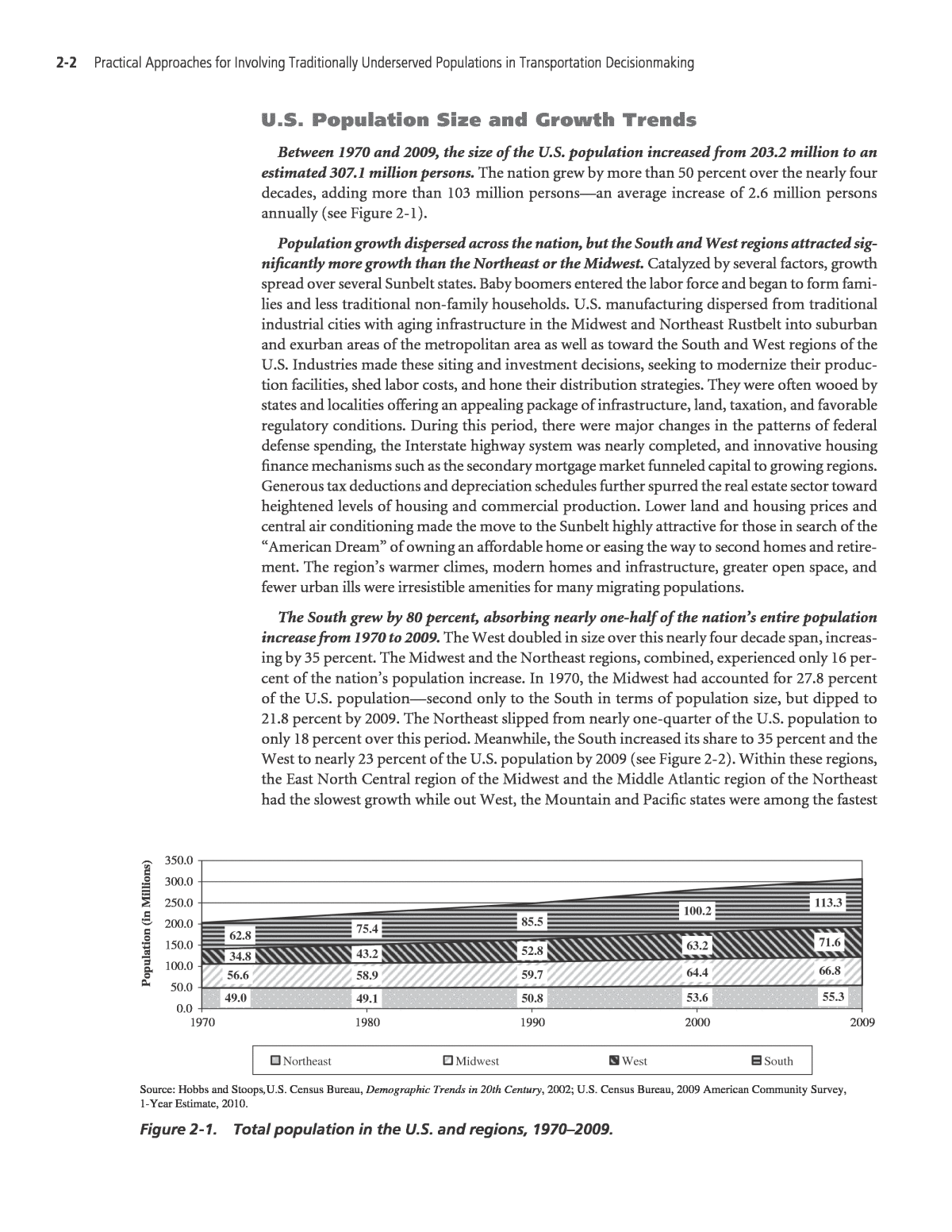
2-2 practical approaches for Involving traditionally Underserved populations in transportation Decisionmaking U.S. Population Size and Growth Trends Between 1970 and 2009, the size of the U.S. population increased from 203.2 million to an estimated 307.1 million persons. The nation grew by more than 50 percent over the nearly four decades, adding more than 103 million personsâan average increase of 2.6 million persons annually (see Figure 2-1). Population growth dispersed across the nation, but the South and West regions attracted sig- nificantly more growth than the Northeast or the Midwest. Catalyzed by several factors, growth spread over several Sunbelt states. Baby boomers entered the labor force and began to form fami- lies and less traditional non-family households. U.S. manufacturing dispersed from traditional industrial cities with aging infrastructure in the Midwest and Northeast Rustbelt into suburban and exurban areas of the metropolitan area as well as toward the South and West regions of the U.S. Industries made these siting and investment decisions, seeking to modernize their produc- tion facilities, shed labor costs, and hone their distribution strategies. They were often wooed by states and localities offering an appealing package of infrastructure, land, taxation, and favorable regulatory conditions. During this period, there were major changes in the patterns of federal defense spending, the Interstate highway system was nearly completed, and innovative housing finance mechanisms such as the secondary mortgage market funneled capital to growing regions. Generous tax deductions and depreciation schedules further spurred the real estate sector toward heightened levels of housing and commercial production. Lower land and housing prices and central air conditioning made the move to the Sunbelt highly attractive for those in search of the âAmerican Dreamâ of owning an affordable home or easing the way to second homes and retire- ment. The regionâs warmer climes, modern homes and infrastructure, greater open space, and fewer urban ills were irresistible amenities for many migrating populations. The South grew by 80 percent, absorbing nearly one-half of the nationâs entire population increase from 1970 to 2009. The West doubled in size over this nearly four decade span, increas- ing by 35 percent. The Midwest and the Northeast regions, combined, experienced only 16 per- cent of the nationâs population increase. In 1970, the Midwest had accounted for 27.8 percent of the U.S. populationâsecond only to the South in terms of population size, but dipped to 21.8 percent by 2009. The Northeast slipped from nearly one-quarter of the U.S. population to only 18 percent over this period. Meanwhile, the South increased its share to 35 percent and the West to nearly 23 percent of the U.S. population by 2009 (see Figure 2-2). Within these regions, the East North Central region of the Midwest and the Middle Atlantic region of the Northeast had the slowest growth while out West, the Mountain and Pacific states were among the fastest 49.0 49.1 50.8 53.6 55.3 56.6 58.9 59.7 64.4 66.8 34.8 43.2 52.8 63.2 71.6 62.8 75.4 85.5 100.2 113.3 0.0 50.0 100.0 150.0 200.0 250.0 300.0 350.0 20092000199019801970 Po pu la tio n (in M illi on s) Northeast Midwest West South Source: Hobbs and Stoops,U.S. Census Bureau, Demographic Trends in 20th Century, 2002; U.S. Census Bureau, 2009 American Community Survey, 1-Year Estimate, 2010. Figure 2-1. Total population in the U.S. and regions, 1970â2009.
patterns, trends, and Factors Driving Change 2-3 growing. This spatial redistribution of growth changed the regional balance of political power in the U.S., and how national fiscal resources were allocated. Population growth has been concentrated primarily in the nationâs metropolitan areas over the 1970 to 2009 period. In 2009, metropolitan areas contained 83.8 percent of the total U.S. population with 16.2 percent living outside the metropolitan region. One-third of the nationâs population lives within the nationâs principal cities, while the suburban and periphery regions account for one-half of the U.S. population. Metropolitan statistical areas were conceived as regions with a core area containing a substantial population nucleus joined with adjacent com- munities that are economically and socially integrated with the core. The âprincipal cityâ is the largest city in each metropolitan statistical area, but additional cities may qualify if specific requirements are met concerning population size and employment. The nationâs metropolitan areas have already have faced significant challenges adjust- ing to their changing fortunes. Las Vegas, Austin, and Phoenix have more than tripled in size since 1970, while Buffalo, Cleveland, Pittsburgh, and Detroit along with other smaller industrial Rustbelt areas have shrunk in size. Metropolitan areas enjoying rapid growth have expanded roadway capacity or made investments in public transportation to meet demand. Where public transportation service extensions to the suburbs have been minimal, such as in Las Vegas, Phoenix, or Orlando, roadway construction has far exceeded public transportation investments. Older metropolitan regions such as Cleveland, Pittsburgh, and Buffalo strain to maintain essential public services, including public transportation, despite a weakening local economy and tax base (Sanchez and Brenman, 2007). Table 2-1 examines the difference in population growth of metropolitan statistical areas (MSAs) with more than 1 million residents in 2009. Even as the nation faces fiscal difficulties and higher rates of joblessness, investments in the nationâs infrastructure must continue to address demographic growth and change, accom- modate the future, and maintain a state-of-good-repair. Ensuring access and mobility for the workforce is one of several transportation-related goals for those who aspire to leadership and governing. Building and maintaining efficient and reliable connections between an expanding fringe and the core areas and âedge citiesâ of the metropolis will be essential to deal with congestion 0.0% 5.0% 10.0% 15.0% 20.0% 25.0% 30.0% 35.0% 40.0% 20091970 Pe rc en t S ha re o f U .S . Northeast Midwest West South Source: Hobbs and Stoops, U.S. Census Bureau, Demographic Trends in 20th Century, 2002; U.S. Census Bureau, 2009 American Community Survey, 1-Year Estimate, 2010. Figure 2-2. Regionâs share of U.S. population, 1970 and 2009.
2-4 practical approaches for Involving traditionally Underserved populations in transportation Decisionmaking and ensure mobility of persons and goods in the face of population growth and to adapt to the nationâs changing social composition. Establishing favorable conditions for a productive economy has been an essential responsi- bility for governing institutions and decisionmakers at all levels of government (federal, state, regional, and local). But encouraging growth through investments or re-investments can have consequences for the livability and health of communities if natural resources and quality-of-life are not protected. Mobilized citizenry, with unprecedented access to information and networks of like-minded groups, are increasingly effective at giving their input and exacting more condi- tions before growth is permitted. Finding the right balance between growth and preservation may bring decisionmakers and the public to embrace a diversity of urban forms as a means for advancing more financially and environmentally sustainable outcomes. In the future, population densities can be expected to increase in the cities but also in the nationâs suburbs. Population growth and the dispersion of population between and within met- ropolitan regions will demand attention; the vocabulary and toolbox to understand and address these challenges will grow as the indicators that are measured and managed expand to include land consumption, environmental and public health, and equity along with more traditional economic measures (see box titled, âEnvironmental Justice Addresses Which Groups?â). Metro Areas 1970 2009 Absolute Change, 1970-2009 Percent Change, 1970- 2009 Rank Percent Change Rank Absolute Change Fastest Growing Metro Regions: Las Vegas-Paradise, NV 273,288 1,902,834 1,629,546 596.3% 1 13 Austin-Round Rock, TX 398,938 1,705,075 1,306,137 327.4% 2 17 Phoenix-Mesa-Scottsdale, AZ 1,039,807 4,364,094 3,324,287 319.7% 3 5 Orlando-Kissimmee, FL 522,575 2,082,421 1,559,846 298.5% 4 15 Riverside-San Bernardino-Ontario, CA 1,139,149 4,143,113 3,003,964 263.7% 5 7 Raleigh-Cary, NC 317,563 1,125,827 808,264 254.5% 6 25 Atlanta-Sandy Springs-Marietta, GA 1,840,280 5,476,664 3,636,384 197.6% 7 4 Tucson, AZ 351,667 1,020,200 668,533 190.1% 8 29 Houston-Sugar Land-Baytown, TX 2,201,849 5,865,086 3,663,237 166.4% 9 3 Dallas-Fort Worth-Arlington, TX 2,424,131 6,447,228 4,023,097 166.0% 10 2 Sacramento-Arden-Arcade-Roseville, CA 847,626 2,127,355 1,279,729 151.0% 11 18 Tampa-St. Petersburg-Clearwater, FL 1,105,553 2,747,272 1,641,719 148.5% 12 12 Miami-Fort Lauderdale-Pompano Beach, FL 2,236,885 5,547,051 3,310,166 148.0% 13 6 Charlotte-Gastonia-Concord, NC-SC 741,118 1,745,524 1,004,406 135.5% 14 23 Salt Lake City, UT 486,031 1,130,293 644,262 132.6% 15 31 Slowest Growing or Declining Metro Regions: Cincinnati-Middletown, OH-KY-IN 1,692,590 2,170,828 478,238 28.3% 37 39 Louisville-Jefferson County, KY-IN 990,050 1,259,031 268,981 27.2% 38 43 Chicago-Naperville-Joliet, IL-IN-WI 7,882,640 9,580,609 1,697,969 21.5% 39 10 Boston-Cambridge-Quincy, MA-NH 3,919,024 4,588,680 669,656 17.1% 40 28 Hartford-West Hartford-East Hartford, CT 1,035,195 1,195,998 160,803 15.5% 41 45 Providence-New Bedford-Fall River, RI-MA 1,394,023 1,600,642 206,619 14.8% 42 44 Philadelphia-Camden-Wilmington, PA-NJ-MD 5,323,603 5,968,252 644,649 12.1% 43 30 New York-New Jersey-Long Island, NY-NJ-PA 17,068,869 19,069,796 2,000,927 11.7% 44 9 Milwaukee-Waukesha-West Allis, WI 1,403,884 1,559,667 155,783 11.1% 45 46 St. Louis, MO-IL 2,551,274 2,825,769 274,495 10.8% 46 42 Rochester, NY 961,516 1,035,566 74,050 7.7% 47 47 New Orleans-Metairie-Kenner, LA 1,125,058 1,189,981 64,923 5.8% 48 48 Detroit-Warren-Livonia, MI 4,435,051 4,403,437 -31,614 -0.7% 49 49 Cleveland-Elyria-Mentor, OH 2,320,572 2,091,286 -229,286 -9.9% 50 51 Pittsburgh, PA 2,759,560 2,354,957 -404,603 -14.7% 51 52 Buffalo-Niagara Falls, NY 1,349,211 1,123,804 -225,407 -16.7% 52 50 Source: U.S. Census Bureau, 2010; Real Estate Center at Texas A&M University, 2010. Table 2-1. Fastest and slowest growing metropolitan areas, 1970â2009 (metropolitan areas with more than 1 million persons in 2009).
patterns, trends, and Factors Driving Change 2-5 Reinventing the nationâs existing metropolitan regions will require persuasive, forward-looking leadership to tackle big issues and to make difficult choices within their region. Technically rigorous research will be needed from agencies and practitioners to inform decisionmakers about these issues and the possible trade-offs associated with solutions. But agencies and practitioners have responsibilities to prepare accessible products and processes as wellâcustomized to different audiences as appropriateâto encourage a broader civic dialogue. Through various forms of information exchange and feedback with citizenry and stakeholders, agencies can be better assured that the fullest range of innovative and workable solutions have been considered towards making sustainable and credible decisions. Minority, Race, and Hispanic Population Patterns Changes in metropolitan area growth have had important effects on the race and ethnic com- position in the central city and suburban areas as shown in Table 2-2, which illustrates how various minority and non-minority populations are distributed in the nation. The nationâs met- ropolitan areas have been ranked in terms of the size of their Hispanic, Black, and Asian popula- tions, the three largest minority segments in the U.S., in Table 2-3. Minority populations remain more concentrated in the nationâs central cities than its suburbs. Minorities, defined as populations other than non-Hispanic Whites, account for 35.1 percent of the U.S. population in 2009, but 50 percent of all persons in the nationâs principal cities within metropolitan areas. Outside the principal cities within the metro- politan region, minorities constitute 30 percent of the population, but only one-fifth of the population living outside the nationâs metropolitan regions in rural America. Of the nationâs Environmental Justice Addresses Which Groups? Title VI of the Civil Rights Act of 1964 prohibits discrimination on the basis of race, color, or national origin. The Office of Management and Budget (OMB) has issued policy directives, identifying five minimum categories for data on race. Executive Order 12898 and the U.S.DOT and FHWA orders on environmental justice address persons belonging to any of the following groups: ⢠Blackâa person having origins in any of the black racial groups of Africa. ⢠Hispanicâa person of Mexican, Puerto Rican, Cuban, Central or South American, or other Spanish culture or origin, regardless of race. ⢠Asianâa person having origins in any of the original peoples of the Far East, Southeast Asia, or the Indian subcontinent. ⢠American Indian and Alaskan Nativeâa person having origins in any of the original people of North America and who maintains cultural identification through tribal affiliation or community recognition. ⢠Native Hawaiian or Other Pacific Islanderâa person having origins in any of the original peoples of Hawaii, Guam, Samoa, or other Pacific Islands. ⢠Low-Incomeâa person whose household income (or in the case of a community or group, whose median household income) is at or below the U.S. Department of Health and Human Services poverty guidelines. Source: Federal Highway Administration and Federal Transit Administration, An Overview of Transportation and Environmental Justice, 2000.
2-6 practical approaches for Involving traditionally Underserved populations in transportation Decisionmaking minorities, Blacks, Hispanics, and Other (i.e., persons of more than one-race) are the least spatially assimilatedâthat is, the most concentrated in the nationâs cities. The concentration of minorities in cities could be viewed as beneficial, given higher levels of accessibility to public transportation options. This could be true if employment opportunities and other amenities such as shopping, good schools, and health care were also concentrated in central cities. But employment growth has been located away from the central cities in the nationâs suburbs (Sanchez and Brenman, 2007). When ranked by size of Hispanic populations, the top 15 metro areas account for six of 10 Hispanics. The Los Angeles and New York metropolitan areas remain the most impor- tant gateways for Hispanics, accounting for 22.1 percent of the nationâs Hispanic popula- Table 2-2. Race, Hispanic, and minority status by type of metropolitan region, 2009. Category U.S. In MSA In MSAâ Principal City In MSAâ Not in Principal City Not in MSA White Alone 229,773,131 187,634,446 63,996,696 123,637,750 42,138,685 - Non-Hispanic White 199,325,978 159,572,131 50,240,194 109,331,937 39,753,847 - Hispanic White 30,447,153 28,062,315 13,756,502 14,305,813 2,384,838 Non-White 77,233,425 69,703,829 37,460,053 32,243,776 7,529,596 - Black or African American 38,093,725 33,924,820 19,383,611 14,541,209 4,168,905 - American Indian and Alaska Native 2,457,552 1,514,139 662,760 851,379 943,413 - Asian 13,774,611 13,340,273 6,766,788 6,573,485 434,338 - Native Hawaiian/Pacific Islander 454,001 383,482 170,657 212,825 70,519 - Other* 22,453,536 20,541,115 10,476,237 10,064,878 1,912,421 Total 307,006,556 257,338,275 101,456,749 155,881,526 49,668,281 Hispanic Origin 48,356,760 44,835,362 22,822,608 22,012,754 3,521,398 Minority Population** 107,680,578 97,766,144 51,216,555 46,549,589 9,914,434 Racial Composition of Population White Alone 74.8% 72.9% 63.1% 79.3% 84.8% - Non-Hispanic White 64.9% 62.0% 49.5% 70.1% 80.0% - Hispanic White 9.9% 10.9% 13.6% 9.2% 4.8% Non-White 25.2% 27.1% 36.9% 20.7% 15.2% - Black or African American 12.4% 13.2% 19.1% 9.3% 8.4% - American Indian and Alaska Native 0.8% 0.6% 0.7% 0.5% 1.9% - Asian 4.5% 5.2% 6.7% 4.2% 0.9% - Native Hawaiian/Pacific Islander 0.1% 0.1% 0.2% 0.1% 0.1% - Other* 7.3% 8.0% 10.3% 6.5% 3.9% Total 100.0% 100.0% 100.0% 100.0% 100.0% Hispanic Origin 15.8% 17.4% 22.5% 14.1% 7.1% Minority Population** 35.1% 38.0% 50.5% 29.9% 20.0% Spatial Distribution of Population by Race White Alone 100.0% 81.7% 27.9% 53.8% 18.3% - Non-Hispanic White 100.0% 80.1% 25.2% 54.9% 19.9% - Hispanic White 100.0% 92.2% 45.2% 47.0% 7.8% Non-White 100.0% 90.3% 48.5% 41.7% 9.7% - Black or African American 100.0% 89.1% 50.9% 38.2% 10.9% - American Indian and Alaska Native 100.0% 61.6% 27.0% 34.6% 38.4% - Asian 100.0% 96.8% 49.1% 47.7% 3.2% - Native Hawaiian/Pacific Islander 100.0% 84.5% 37.6% 46.9% 15.5% - Other* 100.0% 91.5% 46.7% 44.8% 8.5% Total 100.0% 83.8% 33.0% 50.8% 16.2% Hispanic Origin 100.0% 92.7% 47.2% 45.5% 7.3% Minority Population** 100.0% 90.8% 47.6% 43.2% 9.2% Source: U.S. Census Bureau, 2009 American Community Survey, 1-Year Estimate, 2010. * The Other Category includes âsome other race aloneâ or âtwo or more races.â ** Minority population includes all populations but non-Hispanic Whites.
patterns, trends, and Factors Driving Change 2-7 Spatial Distribution: Rank Metro Area 2009 Population Share Metro Area Population In Principal Cities Percent of Principal City Principal Cities Share Outside Principal Cities Hispanic 1 Los Angeles, CA 5, 763, 181 44. 8% 2, 852, 942 46. 5% 49. 5% 50. 5% 2 New York, NY-NJ-PA 4, 151, 211 21. 8% 2, 404, 903 27. 7% 57. 9% 42. 1% 3 Miami, FL 2 , 234 , 001 40. 3% 323 , 805 52. 4% 14. 5% 85. 5% 4 Houston, TX 2, 015, 528 34. 4% 959, 683 42. 4% 47. 6% 52. 4% 5 Riverside, CA 1, 920, 133 46. 3% 511, 163 49. 6% 26. 6% 73. 4% 6 Chicago, IL-IN-WI 1, 902, 323 19. 9% 779, 218 27. 3% 41. 0% 59. 0% 7 Dallas, TX 1, 803, 362 28. 0% 1, 094, 762 35. 1% 60. 7% 39. 3% 8 Phoenix, AZ 1, 382, 427 31. 7% 877, 786 35. 4% 63. 5% 36. 5% 9 San Antonio, TX 1, 107, 864 53. 4% 845, 307 61. 5% 76. 3% 23. 7% 10 San Diego, CA 957, 246 31. 3% 373, 574 28. 6% 39. 0% 61. 0% 11 San Francisco, CA 893, 612 20. 7% 370, 244 20. 0% 41. 4% 58. 6% 12 Washington, DC-VA-MD-WV 712, 951 13. 0% 112, 339 11. 6% 15. 8% 84. 2% 13 McAllen, TX 665, 244 89. 8% n/ a n/ a n/ a n/ a 14 El Paso, TX 614, 467 81. 8% 499, 242 80. 5% 81. 2% 18. 8% 15 Denver, CO 570, 216 22. 3% 305, 931 32. 8% 53. 7% 46. 3% Black 1 New York, NY-NJ-PA 3, 369, 106 17. 7% 2, 249, 680 25. 9% 66. 8% 33. 2% 2 Atlanta, GA 1, 727, 337 31. 5% 277, 976 51. 4% 16. 1% 83. 9% 3 Chicago, IL-IN-WI 1, 683, 203 17. 6% 946, 127 33. 2% 56. 2% 43. 8% 4 Washington, DC-VA-MD-WV 1, 422, 669 26. 0% 367, 875 38. 0% 25. 9% 74. 1% 5 Philadelphia, PA-NJ-DE-MD 1, 221, 558 20. 5% 694, 244 42. 7% 56. 8% 43. 2% 6 Miami, FL 1, 132, 749 20. 4% 143, 541 23. 2% 12. 7% 87. 3% 7 Detroit, MI 1, 002, 212 22. 8% 695, 092 76. 3% 69. 4% 30. 6% 8 Houston, TX 987, 007 16. 8% 513, 449 22. 7% 52. 0% 48. 0% 9 Dallas, TX 904, 709 14. 0% 554, 644 17. 8% 61. 3% 38. 7% 10 Los Angeles, CA 895, 931 7. 0% 502, 609 8. 2% 56. 1% 43. 9% 11 Baltimore, MD 764, 778 28. 4% 396, 518 62. 2% 51. 8% 48. 2% 12 Memphis, TN-MS-AR 580, 308 44. 5% 412, 656 61. 0% 71. 1% 28. 9% 13 Virginia Beach-Norfolk, VA 522, 859 31. 2% 183, 341 27. 5% 35. 1% 64. 9% 14 St. Louis, MO-IL 505, 587 17. 9% 169, 920 47. 7% 33. 6% 66. 4% 15 New Orleans, LA 414, 543 34. 8% 218, 919 61. 7% 52. 8% 47. 2% Asian 1 New York, NY-NJ-PA 1, 807, 680 9. 5% 1, 007, 995 11. 6% 55. 8% 44. 2% 2 Los Angeles, CA 1, 790, 140 13. 9% 790, 292 12. 9% 44. 1% 55. 9% 3 San Francisco, CA 965, 347 22. 4% 503, 058 27. 2% 52. 1% 47. 9% 4 San Jose, CA 555, 003 30. 2% 439, 449 34. 4% 79. 2% 20. 8% 5 Chicago, IL-IN-WI 514, 135 5. 4% 150, 116 5. 3% 29. 2% 70. 8% 6 Washington, DC-VA-MD-WV 471, 763 8. 6% 41, 938 4. 3% 8. 9% 91. 1% 7 Honolulu, HI 378, 101 41. 7% 189, 797 50. 7% 50. 2% 49. 8% 8 Seattle, WA 358, 849 10. 5% 96, 366 11. 8% 26. 9% 73. 1% 9 Houston, TX 355, 203 6. 1% 134, 133 5. 9% 37. 8% 62. 2% 10 Dallas, TX 318, 023 4. 9% 173, 570 5. 6% 54. 6% 45. 4% 11 San Diego, CA 315, 594 10. 3% 189, 668 14. 5% 60. 1% 39. 9% 12 Boston, MA-NH 275, 250 6. 0% 64, 867 7. 9% 23. 6% 76. 4% 13 Philadelphia, PA-NJ-DE-MD 268, 143 4. 5% 88, 927 5. 5% 33. 2% 66. 8% 14 Sacramento, CA 240, 968 11. 3% 109, 820 14. 9% 45. 6% 54. 4% 15 Riverside, CA 239, 056 5. 8% 59, 529 5. 8% 24. 9% 75. 1% Source: U.S. Census Bureau, 2009 American Community Survey, 1-Year Estimate, 2010. Table 2-3. Largest metro areas by race and Hispanic origin by location within metro area, 2009. tion in 2009, but this share is down from 30 percent in 1990, suggesting changes in settle- ment patterns. During this period, interior California areas such as Riverside and Stockton, among other new regions, gained significant numbers of Hispanics (Frey, 2006). The Southeast has become an important destination for Hispanics in recent years, attract- ing migrants to fill jobs in construction, services, and retail. While not the traditional centers for Hispanic populations, nine of the top 10 metro areas in terms of their percentage growth in
2-8 practical approaches for Involving traditionally Underserved populations in transportation Decisionmaking Hispanic populations since 2000 were in the Southeast and include Cape CoralâFort Myers (FL), Port St. Lucie (FL), Charlotte (NC-SC), Fayettesville (AR-MO), Raleigh (NC), Lakeland (FL), Nashville (TN), and Atlanta (GA) (Frey, 2006). While patterns of settlement vary by metropolitan areas, Hispanic population growth has spread to parts of suburbia, particularly in metropolitan areas such as Miami (FL); Washington, D.C.; and Riverside, San Francisco, and San Diego (CA). But Hispanics still constitute a larger proportion of the central city population in most of the major metro areas. Texas metro areas such as San Antonio, Dallas, Houston, and El Paso markedly exhibit this pattern, as do several other metro areas including Phoenix (AZ), Denver (CO), and New York (NY-NJ-PA), among others. Asian populations are more likely than Hispanic populations to be settled within only a small number of major metropolitan areas. Ranked by size of Asian populations, the top 15 metro areas account for over two-thirds of the nationâs Asian population, with the Los Angeles, New York, and San Francisco metro areas serving as home to one-third of the nationâs Asians. However, newer destinations for Asians have grown significantly in the past decade including Las Vegas (NV), Phoenix (AZ), Riverside (CA), and Austin (TX) (Frey, 2006). While Asians are more likely to be concentrated in the primary cities of select metro regionsâ for example, San Francisco, San Jose, Honolulu, San Diego, Sacramento, among othersâthe pattern is far less dramatic than is evident for Hispanics and Blacks. Asians have often settled outside the central city, clustering together in some suburban areas, but also exhibiting a greater tendency over time toward spatial assimilationâmovement away from ethnic enclaves into areas where another ethnic majority predominates. Blacks, in comparison to Asians and Hispanics, are somewhat more dispersed throughout the U.S. The top 15 metro areas ranked by size of Black populations in 2009 contained one- half of all Blacks in the nation. New Yorkâs metropolitan area and primary city have the largest populations of Blacks, but its primary city is more racially and ethnically mixed than many other metro areas. Several of the primary cities within metro areas exhibit majority Black populations, including Detroit (MI), Memphis (TN), Baltimore (MD), Atlanta (GA), and New Orleans (LA). These cities, along with several other major cities including New York, Chicago, Philadelphia, Dallas, Houston, and Los Angeles, exhibit a higher concentration of Blacks in the primary city than in the surrounding suburban areas. The Black population has been steadily reversing historic trends, and returning to southern states over the last two decades. Beginning in the 1970s and 1980s, the movement of blacks southward has been an important migration flow, driving Black population gains in several southern metropolitan areas including Atlanta (GA), Houston (TX), Dallas (TX), Miami (FL), Charlotte (NC), and Washington (DC-VA-MD-WV) (Frey, 2006). Poverty and Low-Income Persons The U.S. Department of Transportation Order on Environmental Justice (5610.2) defines âlow-incomeâ as a person whose household income is at or below the U.S. Department of Health and Human Services (HHS) poverty guidelines. Several federal programs use the poverty guide- lines (or percentage multiples of the guidelinesâfor instance, 130 percent or 185 percent of the guidelines) in determining eligibility. Programs that reference poverty guidelines include Head Start, the Supplemental Nutrition Assistance Program (SNAP), the National School Lunch Pro- gram, the Low-Income Home Energy Assistance Program, and the Childrenâs Health Insurance Program. Table 2-4 presents how the poverty levels vary by household size. The poverty level for a family of four was $22,350 under the 2011 guidelines for the 48 contiguous states and the
patterns, trends, and Factors Driving Change 2-9 District of Columbia. Cost-of-living adjustments are made for those living in Alaska and Hawaii, but not for the other 48 states and the District of Columbia. Who Are the Poor? In 2009, about one out of seven U.S. residents lived in poverty with an official poverty rate of 14.3 percent. There were an estimated 43.6 million persons in poverty in the U.S.âthe third consecutive annual increase in the number of people in poverty. This was the largest number of persons ever reported in poverty since estimates were first published in 1959. The poverty rate in 2009 was the highest poverty rate since 1994, but it was 8.1 percentage points lower than in 1959. Most persons living in poverty were White in 2009â29.8 million were White and 18.5 mil- lion were non-Hispanic Whites. Whites in poverty accounted for about 68 percent of all persons in poverty. Hispanics and Blacks accounted for 28 and 23 percent, respectively, of all persons in poverty in 2009. Hispanics and Blacks exhibit persistently higher rates of poverty than non-Hispanic Whites. The poverty rate was 25.3 percent for Hispanics and 25.8 percent for Blacksâfar higher than the 9.4 percent rate for non-Hispanic Whites in 2009. This gap persists even as it closed somewhat over the 1990s particularly for Blacks. In recent years, the gap has widened with the economic slowdown and current policy priorities (see Figure 2-3). Many persons in poverty are children and youth. More than one out of five children lives in poverty (15.4 million persons under 18 years). Seniors account for 3.4 million persons in poverty, but their poverty rate is proportionately less than for children or for adults 18 to 64 years (see Table 2-5). Single-parent, female-headed families without husbands are among the most vulnerable to falling into poverty, particularly those with children under 18 years. Single-parent female- headed families account for 18 percent of all families, but 50 percent of all families in poverty. While 11.1 percent of all U.S. families are in poverty, 29.9 percent of all female-headed families are in poverty. The poverty rate for all types of families rises when children under 18 years are present, but it is especially high for single-parent families headed by female Hispanics (46%) or Blacks (44.2%). For Hispanics and Blacks, current poverty levels are actually lower than experienced in the 1970s and 1980s, even as the rate rose during the 2000s. For White women (non-Hispanics) with children, there has been a rise in poverty levels over this same period, actually accelerating in the last decade to close some of the gap between the races (see Figure 2-4). Number of Persons In Household 48 Contiguous States and D.C. Alaska Hawaii 1 $10,890 $13,600 $12,540 2 14,710 18,380 16,930 3 18,510 23,160 21,320 4 22,350 27,940 25,710 5 25,170 32,720 30,100 6 29,990 37,500 34,490 7 33,810 42,280 38,880 8 37,630 47,060 43,270 For each additional person, add 3,820 4,780 4,390 Source: U.S. Department of Health and Human Services. Annual Update of the HHS Poverty Guidelines, 2011. Table 2-4. 2011 poverty guidelines.
2-10 practical approaches for Involving traditionally Underserved populations in transportation Decisionmaking 0.0 5.0 10.0 15.0 20.0 25.0 30.0 35.0 40.0 19 73 19 75 19 77 19 79 19 81 19 83 19 85 19 87 19 89 19 91 19 93 19 95 19 97 19 99 20 01 20 03 20 05 20 07 20 09 Pe rc en t i n Po ve rt y All Races White (not Hispanic) Black Asian Hispanic (all Races) Source: De-Navas-Walt, C., Proctor, B.D, and Smith, J.C., U.S. Census Bureau, Income, Poverty and Health Insurance Coverage in the U.S.: 2009, September 2010. Note: Data not reported for Pacific Islanders, Alaska Natives, and Native Americans in census publication. Figure 2-3. Poverty rates for persons by race and Hispanic origin, 1973â2009. Category Population Persons in Poverty Percent in Poverty Share of U.S. Population Share of All in Poverty People: Total 303, 820 43, 569 14 .3 % 100. 0% 100. 0% White 242, 047 29, 830 12 .3 % 79 .7 % 68 .5 % Non-Hispanic White 197, 164 18, 530 9. 4% 64 .9 % 42 .5 % Hispanic (any Race) 48, 811 12, 350 25. 3% 16. 1% 28. 3% Black or African American 38, 556 9, 9 44 25 .8 % 12 .7 % 22 .8 % Asian 14, 005 1, 7 46 12 .5 % 4. 6% 4. 0% In Families 249, 834 31, 197 12 .5 % 82 .2 % 71 .6 % Householder 78, 867 8, 7 92 11 .1 % 26 .0 % 20 .2 % Related Children, under 18 Years 73, 410 14, 774 20 .1 % 24 .2 % 33 .9 % In Unrelated Subfamilies 1, 3 57 6 93 51 .1 % 0. 4% 1. 6% Unrelated Individuals 53, 079 11, 678 22 .0 % 17 .5 % 26 .8 % Age Under 18 Years 74, 579 15, 451 20 .7 % 24 .5 % 35 .5 % 18 to 64 Years 190, 627 24, 684 12 .9 % 62 .7 % 56 .7 % 65 Years and Older 38, 613 3, 4 33 8. 9% 12 .7 % 7. 9% Nativity Native Born 266, 223 36, 407 13 .7 % 87 .6 % 83 .6 % Foreign Born 37, 597 7, 1 62 19 .0 % 12 .4 % 16 .4 % - Naturalized Citizen 16, 024 1, 7 36 10 .8 % 5. 3% 4. 0% - Not a Citizen 21, 573 5, 4 25 25 .1 % 7. 1% 12 .5 % Residence Inside Metropolitan Statistical Areas 256, 028 35, 655 13 .9 % 84 .3 % 81 .8 % Inside Principal Cities 97, 725 18, 261 18 .7 % 32 .2 % 41 .9 % Outside Principal Cities 158, 302 17, 394 11 .0 % 52 .1 % 39 .9 % Outside Metropolitan Statistical Areas 47, 792 7, 9 14 16 .6 % 15 .7 % 18 .2 % Families: Total Families 78, 874 8, 7 92 11 .1 % 100. 0% 100. 0% Married Couple 58, 428 3, 4 09 5. 8% 74 .1 % 74 .1 % Female Householder, no husband present 14, 857 4, 4 41 29 .9 % 18 .8 % 18 .8 % Male Householder, no wife present 5, 5 82 9 42 16 .9 % 7. 1% 7. 1% Source: De-Navas-Walt, C., Proctor, B.D., and Smith, J.C., U.S. Census Bureau, Income, Poverty and Health Insurance Coverage in the U.S.: 2009, September 2010. Note: Data not reported for Pacific Islanders, Alaska Natives, and Native Americans in census publication. Table 2-5. People and families in poverty by select characteristics, 2009.
patterns, trends, and Factors Driving Change 2-11 Location of the Poor The poor are increasingly spread out over our metro- politan regions, but they are most concentrated in our central cities. In terms of absolute numbers of persons in poverty, those living outside the central city account for nearly as many persons in poverty (17.4 million) as those living within the central city (18.3 million). The poverty rate in the central cities (18.7%) is significantly higher, however, than the outer areas of the metropolitan region (11%). Many of the poor also live in rural areas outside metro- politan regionsâ7.9 million persons or 18 percent of the nationâs poor live outside metropolitan areas in poverty. Those living in rural areas exhibit a 16.2 percent poverty rateâsecond only to our nationâs central cities in terms of the percent of the population below the poverty threshold (see Table 2-5). Foreign-Born Residents Over the first decade of the 21st century, the total number of foreign-born residents in the U.S. was at an all-time high; the total foreign born as a percent of the total U.S. population approached percentages last reached in 1920. Large migrating populations, including immi- grants, sought economic opportunities in the Northeast and Midwest until the Depression of the late 1920s and 1930s slowed immigration. In the aftermath of World War II, the supply of European labor diminished as a post-war recovery took hold. 0.0 10.0 20.0 30.0 40.0 50.0 60.0 70.0 19 73 1 9 75 19 77 19 79 19 81 19 83 19 85 19 87 19 89 19 91 19 93 19 95 19 97 19 99 20 01 20 03 20 05 20 07 20 09 Pe rc en t i n Po ve rt y All Families Female HH - White (not Hispanic) w/Child Female HH - Black w/Child Female HH - Asian w/Child Female HH - Hispanic (all Races) w/Child Female HH - All Races Source: De-Navas-Walt, C., Proctor, B.D., and Smith, J.C., U.S. Census Bureau, Income, Poverty and Health Insurance Coverage in the U.S.: 2009, September 2010. Note: Data not reported for Pacific Islanders, Alaska Natives, and Native Americans in census publication. Figure 2-4. Poverty rates for families and female-headed families w/children by race and Hispanic origin, 1973â2009. Poverty and Low-Income Persons: Challenges and Considerations ⢠Limited access to information via Internet or sub- scription newspapers. ⢠Limited ability to read and write English or a non- English language. ⢠Limited access to a personal vehicle and subject to the scheduling and routes of public transit, if available. ⢠Time restrictions attributable to working second or third shifts or two jobs. ⢠Time restrictions attributable to single parent and multi-generational family structures.
2-12 practical approaches for Involving traditionally Underserved populations in transportation Decisionmaking The foreign-born share of the U.S. population continued to drop in the 1950s and 1960s, bot- toming out in the 1970s before steadily increasing until 2009 when the recession slowed the pace of immigration. The Sunbelt states emerged and spread out in this period as already discussed. Immigrant settlements followed this engine of economic opportunity as the Sunbelt spread from the West into the Southwest and Southeast, and as it spread out from the traditional urban cores to the suburban and exurban periphery. Between 2000 and 2009, the total foreign-born population increased by 23.8 percent from 31.1 to 38.5 million (see Figure 2-5). Foreign-born residents constituted about 12.5 percent of the total U.S. population in 2009, and approximately 42 percent of U.S. population growth has been estimated to come directly from immigration. The foreign-born population includes natu- ralized citizens, lawful permanent residents (LPRs), certain legal non-immigrants (e.g., persons on student or work visas), those admitted as refugees or asylum seekers, and persons illegally residing in the United States. The nationâs deep recession has diminished the estimated annual flow of unauthorized immigration from its peaks earlier in the decade. While the exact per- centages are not known, an estimated 28 percent of immigrants in the U.S. were believed to be unauthorized in 2009, which is down from a high of 31 percent in 2007 (Passel and Cohn, 2010). Foreign-born residentsâpersons residing in the United States who were not U.S. citizens at birthâare expected to account for a greater proportion of population growth than natural increase by 2027. Current immigrant populations come primarily from Asia, Mexico, and South and Central Americaâa significant transformation of the regions of origin from the first few decades of the twentieth century. In 1970, European immigrants made up 62 percent of the foreign-born population in the U.S., but by 2009 they accounted for only 13 percent of foreign-born popula- tions due to new waves of immigration and the aging of existing immigrant populations (see Figure 2-6). Mexico is the leading country of origin for foreign-born persons in the United States today, accounting for just under 30 percent of the U.S. foreign-born, but the Philippines, India, China, Vietnam, and El Salvador are also major source countries. Table 2-6 shows the top 20 originating countries of foreign-born populations in 2009 which comprise about 72 percent of the nationâs foreign-born populations. 11.6% 8.8% 6.9% 5.4% 4.7% 6.2% 7.9% 11.1% 12.5% 14.7% 13.6% 13.2% 12.6% 0.0 5.0 10.0 15.0 20.0 25.0 30.0 35.0 40.0 45.0 190 0 191 0 192 0 193 0 194 0 195 0 196 0 197 0 198 0 199 0 200 0 200 8 200 9 Po pu la tio n in M ill io ns 0.0% 5.0% 10.0% 15.0% 20.0% 25.0% Pe rc en t o f T ot al P op ul at io n Total Foreign-Born Population (M) Percent of Total Population Source: U.S. Census Bureau, American Community Survey; Gibson, C. and Lennon, E., U.S. Census Bureau, Historical Census Statistics on the Foreign-Born Population of the United States: 1850 to 2000, U.S. Government Printing Office, Washington, DC, 2006. Figure 2-5. Total foreign born and share of foreign born, 1900â2009.
patterns, trends, and Factors Driving Change 2-13 The regions and countries of origin, the customs, English proficiency, and the factors that will drive the nationâs future immigrants to the United States may not be fully foreseeable today, but recognition of changing migration patterns and respect for those who arrive will be essential to designing accessible public involvement processes and to reaching a better under- standing of the values, needs, and concerns of the nationâs increasingly diverse communities and populations. Destinations for Foreign-Born Populations Are Changing Traditional gateways such as California, New York, Texas, and Florida continued to be major points of entry throughout the first decade of the 21st century, but foreign-born persons also arrived in many other statesâmore than had ever been recorded in their recent history (see Table 2-7). Figure 2-7 presents the 15 states receiving the most immigrants since 2000; Source: U.S. Census Bureau, American Community Survey; Gibson, C. and Lennon, E., U.S. Census Bureau, Historical Census Statistics on the Foreign-Born Population of the United States: 1850 to 2000, U.S. Government Printing Office, Washington, DC, 2006. 1970 Europe 62% Other 9% Asia 9% Mexico 8% Other Latin America 11% Africa 1% 2009 Asia 28% Europe 13% Mexico 29% Other Latin America 23% Africa 4% Other 3% Figure 2-6. Originating regions for foreign-born populations, 1970 and 2009. Table 2-6. Top 20 originating countries of foreign born, 2009. Rank Country of Origin Foreign-Born Population Share of Foreign-Born 1 Mexico 11,478,413 29.8% 2 Philippines 1,725,894 4.5% 3 India 1,665,219 4.3% 4 China 1,432,115 3.7% 5 Vietnam 1,152,384 3.0% 6 El Salvador 1,149,895 3.0% 7 Korea 1,004,329 2.6% 8 Cuba 991,385 2.6% 9 Canada 814,965 2.1% 10 Guatemala 798,682 2.1% 11 Dominican Republic 793,285 2.1% 12 United Kingdom 694,597 1.8% 13 Jamaica 651,177 1.7% 14 Germany 622,608 1.6% 15 Colombia 609,845 1.6% 16 Haiti 538,582 1.4% 17 Honduras 467,943 1.2% 18 Poland 443,173 1.2% 19 Ecuador 411,826 1.1% 20 Peru 406,910 1.1% Source: U.S. Census Bureau, 2009 American Community Survey, 1-Year Estimate, 2010.
2-14 practical approaches for Involving traditionally Underserved populations in transportation Decisionmaking Table 2-7. States ranked by number of foreign born: 1990, 2000, 2009. State 1990 Estimate Rank 2000 Estimate Rank 2009 Estimate Rank United States 19,767,316 31,107,889 38,517,234 California 6,458,825 1 8,864,255 1 9,946,758 1 New York 2,851,861 2 3,868,133 2 4,178,170 2 Texas 1,524,436 4 2,899,642 3 3,985,239 3 Florida 1,662,601 3 2,670,828 4 3,484,141 4 New Jersey 966,610 5 1,476,327 6 1,759,467 5 Illinois 952,272 6 1,529,058 5 1,740,763 6 Massachusetts 573,733 7 772,983 7 943,335 7 Arizona 278,205 14 656,183 8 925,376 8 Georgia 173,126 16 577,273 10 920,381 9 Washington 322,144 10 614,457 9 810,637 10 Virginia 311,809 12 570,279 11 805,742 11 Maryland 313,494 11 518,315 13 730,400 12 Pennsylvania 369,316 8 508,291 14 691,242 13 North Carolina 115,077 21 430,000 15 665,270 14 Michigan 355,393 9 523,589 12 614,111 15 Nevada 104,828 23 316,593 19 506,505 16 Colorado 142,434 18 369,903 17 486,615 17 Connecticut 279,383 13 369,967 16 459,515 18 Ohio 259,673 15 339,279 18 433,330 19 Oregon 139,307 19 289,702 20 367,202 20 Minnesota 113,039 22 260,463 21 357,561 21 Indiana 94,263 25 186,534 24 281,327 22 Tennessee 59,114 31 159,004 25 265,658 23 Wisconsin 121,547 20 193,751 23 256,085 24 Hawaii 162,704 17 212,229 22 224,227 25 Utah 58,600 33 158,664 26 218,142 26 Missouri 83,633 27 151,196 27 212,900 27 South Carolina 49,964 34 115,978 32 205,133 28 New Mexico 80,514 28 149,606 28 196,006 29 Oklahoma 65,489 29 131,747 30 189,841 30 Kansas 62,840 30 134,735 29 171,252 31 Louisiana 87,407 26 115,885 33 152,002 32 Alabama 43,533 35 87,772 35 146,999 33 Rhode Island 95,088 24 119,277 31 133,458 34 Kentucky 34,119 39 80,271 36 127,973 35 Arkansas 24,867 42 73,690 38 120,231 36 Iowa 43,316 36 91,085 34 116,161 37 Nebraska 28,198 41 74,638 37 106,186 38 Idaho 28,905 40 64,080 40 97,642 39 Delaware 22,275 44 44,898 42 74,033 40 District of Columbia 58,887 32 73,561 39 72,110 41 New Hampshire 41,193 37 54,154 41 68,462 42 Mississippi 20,383 45 39,908 43 59,538 43 Alaska 24,814 43 37,170 44 48,849 44 Maine 36,296 38 36,691 45 43,958 45 West Virginia 15,712 47 19,390 47 23,129 46 South Dakota 7,731 50 13,495 49 21,765 47 Vermont 17,544 46 23,245 46 20,537 48 Montana 13,779 48 16,396 48 19,309 49 Wyoming 7,647 51 11,205 51 17,108 50 North Dakota 9,388 49 12,114 50 15,453 51 Source: U.S. Census Bureau, Summary File 3, U.S. Decennial Censuses: 1990 and 2000; U.S. Census Bureau, 2009 American Community Survey, 1-Year Estimate, 2010.
patterns, trends, and Factors Driving Change 2-15 they accounted for 80 percent of all foreign-born entering the country in the first decade of the century. Until recently, several Southeastern and Midwestern states had only limited experience as destinations for foreign-born populations. The foreign-born arriving since 2000 in North Carolina, Georgia, Minnesota, Indiana, Kentucky, and Tennessee account for nearly 40 to 50 percent of their stateâs entire foreign-born populations. Figure 2-8 presents the top 15 states in terms of the share of the foreign-born population that arrived in their state since 2000. The deep recession at the end of the decade inhibited the migration of foreign-born persons, but among the 100 largest metropolitan areas, the foreign-born population still grew by 21.3 percent from 2000 to 2008, an annual growth rate of 2.4 percent. This rate of migration falls well short of the 4.5 percent annual rate of the 1990s, but the foreign born increasingly settled in regions of the country and metropolitan areas that traditionally had not been points- of-entry (see Singer, 2009). Southeastern metropolitan areasâplaces that immigrants had not chosen for settle - ment in recent decadesâhave drawn much larger contingents of foreign born since 2000 (see Tables 2-8 and 2-9). Several metro areas such as Lexington-Fayette (KY); Jackson (MS); Durham-Chapel Hill, Asheville, Winston-Salem, Raleigh-Cary, and Charlotte (NC); Birmingham Distribution of Foreign Born by Year of Entry 0% 10% 20% 30% 40% 50% 60% 70% 80% 90% 100% Ca lifo rni a Te xa s Flo rid a Ne w Yo rk Ne w Jer sey Illi no is Ge org ia Ma ssa chu set ts Vi rgi nia No rth Ca rol ina Ar izo na Pe nn syl van ia Wa shi ng ton Ma ryl and Mi chi gan Pe rc en t o f T ot al F or ei gn B or n 0 2 4 6 8 10 12 To ta l N um be r of F or ei gn B or n (in M ) Entered Before 1980 Entered 1980-1989 Entered 1990-1999 Entered 2000 or later Foreign Born in 2009 (in M) Source: U.S. Census Bureau, Summary File 3, U.S. Decennial Census: 2000; U.S. Census Bureau, 2009 American Community Survey, 1-Year Estimate, 2010. Figure 2-7. States with the largest number of foreign-born populations entering, 2000â2009 share of total foreign born by year of entry.
2-16 practical approaches for Involving traditionally Underserved populations in transportation Decisionmaking (AL); Memphis (TN); and Greenville (SC) have ranked among the most attractive in terms of new arrivals since 2000 as a share of their total foreign born. Several metro areas in older industrial states have experienced an infusion of foreign-born arrivals such as Indianapolis (IN), East Lansing (MI), Harrisburg (PA), and Omaha (NE). The larger metro areas, such as New YorkâNew Jersey, Los Angeles, Miami, San Francisco, and Houston still have a much larger share of the foreign-born as a percentage of the total population. Similarly, the border states as traditional gateways for low-skilled labor are much more com- posed of foreign-born persons. When metro areas are ranked by the percentage of foreign-born, 12 of the top 15 are in the Sunbelt states, all with longstanding immigrant populations. Ten are in California (San Jose, Los Angeles, San Francisco, Stockton, Salinas, San Diego, Oxnard, Santa Barbara, Visalia, Modesto); two are situated along the Texas border (McAllen and El Paso); and Las Vegas, Miami, and New York round out the top 15. While change is occurring at a rapid pace for these new destination regions, the absolute num- ber of foreign-born arrivals since 2000 is far smaller than those destined for the top arrival metro areas or traditional areas of migration. Long-standing residents may express concern over the effects of immigrant populations on local services such as schools, health care, and transportation; but the residents, employers, and governing institutions of these newer destination regions, no less than the traditional gateways, can seek ways to build their cultural competency to effectively integrate and engage new immigrant communities and their families. Figure 2-8. States with largest share of percent of total foreign-born populations, 2000â2009. Distribution of Foreign Born by Year of Entry 0% 10% 20% 30% 40% 50% 60% 70% 80% 90% 100% Ge org ia No rth Ca rol ina Mi nn eso ta Ind ian a Te nn ess ee So uth Ca rol ina Mi sso uri Ka nsa s Al ab am a Ke ntu ck y Ne bra ska De law are Mi ssi ssi pp i So uth D ak ota No rth D ak ota Pe rc en t o f T ot al F or ei gn B or n 0.000 0.200 0.400 0.600 0.800 1.000 1.200 T ot al N um be r of F or ei gn B or n (in M ) Entered Before 1980 Entered 1980-1989 Entered 1990-1999 Entered 2000 or later Foreign Born in 2009 (in M) Source: U.S. Census Bureau, Summary File 3, U.S. Decennial Census: 2000; U.S. Census Bureau, 2009 American Community Survey, 1-Year Estimate, 2010.
Table 2-8. Metro areas ranked by absolute size and share of foreign-born populations, 2009. Ranked by Size of Foreign-Born Populations: Ranked by Share of Foreign-Born Populations: Metro Areas Total Foreign Born Share of Foreign Born Metro Areas Total Foreign Born Share of Foreign Born 1 Ne w Yo rk , NY -N J-PA 5, 826, 648 30. 6% 1 Miami-Fort Lauderdale-Pompano Beach, FL 2, 215, 218 39. 9% 2 Lo s An ge le s- Lo ng Be ac h- Sa nt a An a, CA 4, 550, 875 35. 3% 2 Sa n Jo se -S un ny va le -S an ta Cl ar a, CA 673, 528 36. 6% 3 Mi am i- Fo rt La uder da le -P om pa no Be ac h, FL 2, 215, 218 39. 9% 3 Lo s An ge le s- Lo ng Be ac h- Sa nt a An a, CA 4, 550, 875 35. 3% 4 Ch ic ag o- Na pe rv ille -J ol ie t, IL -I N- WI 1, 758, 250 18. 4% 4 Sa n Fr an ci sc o- Oa kl an d- Fr emont, CA 1, 332, 458 30. 9% 5 Ho us ton- Su ga r La nd -B ay to wn , TX 1, 337, 222 22. 8% 5 Sa lin as , CA 125, 529 30. 6% 6 Sa n Fr an ci sc o- Oa kl an d- Fr emont, CA 1, 332, 458 30. 9% 6 Ne w Yo rk , NY -N J-PA 5, 826, 648 30. 6% 7 Da lla s- Fo rt Wo rt h- Ar lin gton , TX 1, 212, 557 18. 8% 7 Mc A lle n- Ed in bu rg -M i ssi on , TX 222, 938 30. 1% 8 Wa sh in gton , DC -V A- MD -W V 1, 207, 433 22. 0% 8 El Pa so , TX 206, 944 27. 5% 9 Ri ve rs id e- Sa n Be rn ar di no -O nt ar io , CA 934, 262 22. 5% 9 St oc kt on , CA 166, 939 24. 7% 10 Bo st on -C am br id ge -Q ui nc y, MA -N H 808, 698 17. 6% 10 Sa n Di ego- Ca rl sb ad -S an Ma rc os , CA 748, 444 24. 5% 11 At la nt a- Sa nd y Sp ri ng s- Ma ri e tta , GA 780, 233 14. 2% 11 Ox na rd -T hous an d Oa ks -V entu ra , CA 193, 674 24. 1% 12 Sa n Di ego- Ca rl sb ad -S an Ma rc os , CA 748, 444 24. 5% 12 Sa nt a Ba rb ar a- Sa nt a Ma ri a- Go le ta , CA 95, 897 23. 6% 13 Ph oeni x- Me sa -S co tts da le , AZ 721, 152 16. 5% 13 La s Ve ga s- Pa ra di se , NV 446, 895 23. 5% 14 Sa n Jo se -S un ny va le -S an ta Cl ar a, CA 673, 528 36. 6% 14 Vi sa lia -P or te rv ille , CA 100, 001 23. 3% 15 Ph ila de lp hi a, PA -N J- DE -M D 667, 863 11. 2% 15 Mo de st o, CA 118, 474 23. 2% 16 Se a ttl e- Ta co ma -B e lle vu e, WA 600, 153 17. 6% 16 Or la ndo- Ki ssi mmee, FL 477, 813 22. 9% 17 Or la ndo- Ki ssi mmee, FL 477, 813 22. 9% 17 Ho us ton- Su ga r La nd -B ay to wn , TX 1, 337, 222 22. 8% 18 La s Ve ga s- Pa ra di se , NV 446, 895 23. 5% 18 Br id gepo rt -S ta mf or d- No rw al k, CT 205, 007 22. 7% 19 De tr oi t- Wa rr en -L iv on ia , MI 424, 698 9. 6% 19 Ri ve rs id e- Sa n Be rn ar di no -O nt ar io , CA 934, 262 22. 5% 20 Ta mp a- St . Pe te rs bu rg -C le ar wa te r, FL 407, 675 14. 8% 20 Ho no lu lu , HI 203, 459 22. 4% 21 Sa cr am ento -A rd en -A rc ad e- Ro se v ille , CA 387, 363 18. 2% 21 Wa sh in gton , DC -V A- MD -W V 1, 207, 433 22. 0% 22 De nv er -A ur or a- Br oom fi el d, CO 330, 562 12. 9% 22 Fr es no , CA 201, 392 22. 0% 23 Mi nne ap o lis -S t. Pa ul -B l oom in gton , MN -W I 320, 006 9. 8% 23 Va lle jo -F ai rf ie ld , CA 88, 086 21. 6% 24 Po rt la nd -V an co uv er -B ea ve rt on , OR -W A 298, 322 13. 3% 24 Ba ke rs fi el d, CA 166, 733 20. 7% 25 Au st in -R ound Ro ck , TX 276, 015 16. 2% 25 Da lla s- Fo rt Wo rt h- Ar lin gton , TX 1, 212, 557 18. 8% Source: U.S. Census Bureau, 2009 American Community Survey, 1-Year Estimate, 2010.
2-18 practical approaches for Involving traditionally Underserved populations in transportation Decisionmaking Immigrants are also increasingly settling away from the urban core within metro areas, changing the demographic composition of suburbia. In 1980, 41 percent of immigrants in the U.S. lived in the primary cities of the top 100 metro areas. Recent immigrants may be just as likely to make their first homes in suburbs as in central cities (Garnett, 2007). Foreign-born residents come from many different regions of the world with varying economic and educational backgrounds, some of whom are prepared for professions requiring advanced degrees, while others, particularly undocumented immigrants, have much less formal educa- tion and skills and can pursue only lower-wage offerings. There is a significant occupational and educational divide among U.S. immigrants, split between groups with a substantially higher percentage with advance degrees and a substantially higher share with less than a high school education (Council of Economic Advisers, 2007). Immigrants may also find that their formal education or training is not accepted by U.S. institutions or businesses. More than half of legal migrants reported taking jobs that are below their skill levels (Akresh, 2006). Over time, the foreign born may eventually disperse toward a wide range of residential and labor markets to pursue employment or education or advance their careersâa form of spatial assimilationâbut may initially gravitate toward enclaves where it is easier to join extended families or network with clusters of prior arrivals from their region or country of origin. While varying by region and/or country of origin, the foreign-born, on average, have lower overall edu- cational attainment levels, higher rates of poverty, and less proficiency in English than native-born Table 2-9. Metro areas: absolute number and share of foreign-born populations, 2009 (ranked by size of foreign born arriving since 2000). Metro Areas Total Foreign Born Share of Foreign Born Foreign Born Arriving Since 2000 1 Le xi ngton- Fa ye tte , KY 33, 343 7. 1% 57. 9% 2 Ja ck so n, MS 14, 449 2. 7% 55. 6% 3 In di an ap o lis -C ar me l, IN 110, 529 6. 3% 51. 3% 4 La ns in g- Ea st La ns in g, MI 27, 125 6. 0% 50. 9% 5 Du rh am -C ha pe l H ill, NC 62, 413 12. 5% 46. 9% 6 As hev ille , NC 25, 501 6. 2% 46. 4% 7 Wi ns ton- Sa le m, NC 41, 703 8. 6% 45. 9% 8 Bi rm in gh am -H oo ve r, AL 51, 659 4. 6% 44. 8% 9 Me mp hi s, TN -M S- AR 69, 848 5. 4% 44. 7% 10 Gr eenv ille -M au ld in -E as le y, SC 50, 302 7. 9% 44. 6% 11 Co lu mb us , OH 136, 359 7. 6% 44. 3% 12 Ra le ig h- Ca ry , NC 137, 836 12. 2% 43. 6% 13 Ch ar lo tte -G as toni a- Co nc or d, NC -S C 187, 642 10. 7% 43. 6% 14 Lo ui sv ille -Je ffe rs on Co unty , KY -I N 59, 440 4. 7% 43. 5% 15 Ci nc i nna ti -M id dl etow n, OH -K Y- IN 93, 753 4. 3% 42. 2% 16 Sc ra nton âW ilk es -B a rre , PA 27, 283 5. 0% 41. 3% 17 Ka ns as Ci ty , MO -K S 132, 642 6. 4% 41. 2% 18 Na sh v ille -D av id so n- Mu rf r ees bo ro -F ra nk lin , TN 127, 160 8. 0% 41. 2% 19 Ha rri sb ur g- Ca r lis le , PA 30, 946 5. 8% 41. 0% 20 Mo b ile , AL 14, 953 3. 6% 40. 9% 21 Ma di so n, WI 41, 014 7. 2% 40. 4% 22 At la nt a- Sa nd y Sp ri ng s- Ma ri e tta , GA 780, 233 14. 2% 40. 4% 23 Mi nne ap o lis -S t. Pa ul -B l oom in gton , MN -W I 320, 006 9. 8% 40. 1% 24 Om ah a- Co unc il Bl u ffs , NE -I A 66, 827 7. 9% 39. 8% 25 Tu ls a, OK 55, 892 6. 0% 39. 7% Source: U.S. Census Bureau, 2009 American Community Survey, 1 Year Estimate, 2010.
patterns, trends, and Factors Driving Change 2-19 residents. This is largely because of the high proportion of immigrants from Mexico. In 2009, the foreign-born were more likely to be in the U.S. labor force and, when employed, tended to work in occupations such as con- struction, production, and services than the native-born. The foreign born rely more upon public transporta- tion to commute to work and are more likely to reside in a household without a car. Changes in foreign-born mode choice tend to be most dramatic during the first five years in the U.S. Immigrants who have been in the U.S. less than one year are less reliant on autosâjust one- third drive to work in a single occupancy vehicle. But more than one-half of those who have been in the coun- try for just five years drive alone to work. The rate of solo commuting becomes higher and the rate of transit and carpooling lessens, the longer that the foreign born have been in the U.S. (Chatman and Klein, 2009). Where the foreign born settleâthe type of urban form in which they live and work and the availability of alternative modes to access opportunities (i.e., work, shopping, health care, education)âremain important factors when explaining the changing travel patterns of immigrants. Figure 2-9 provides a quick snapshot comparison of foreign-born residents with native-born populations. However, when considering how best to reach the foreign born in local com- munities, practitioners will do best to avoid generalizations about the foreign born and look very closely at who comprise the foreign born in their specific communities. This can begin with examination of the American Community Survey and other supplementary publications. 0% 10% 20% 30% 40% 50% 60% 70% 80% 90% 100% Walk Carpool Commute by public transit Zero-vehicle households Speak English less than âvery wellâ English only at home Less than high school graduate Bachelor degree or higher Below 100 percent of the poverty level (HHs) 100 to 150 percent of the poverty level (HHs) Construction, Maintenance Occupations Production, Transportation Occupations Service Occupations Unemployed In Labor Force Foreign Native Source: U.S. Census Bureau, 2009 American Community Survey, 1 Year Estimate, 2010. 6.5% 6.4% 68.7% 64.7% 24.6% 16.5% 11.2% 11.6% 15.5% 8.1% 9.2% 12.6% 17.5% 14.3% 26.8% 32.3% 11.4% 28.1% 52.0% 1.9% 13.1% 10.5% 4.0% 15.4% 3.8% 2.7% 15.5% 9.0% 9.0% 90.0% Figure 2-9. Comparison of U.S. native and foreign-born populations, 2009 (HH = household). Foreign Born: Challenges and Considerations ⢠Lack of familiarity with customs and the planning process; unease with meetings as a safe venue for expressing oneself. ⢠Limited access to information via Internet or sub- scription newspapers. ⢠Limited ability to read and write English or a non- English language. ⢠Increased dependency on children for information or explanation. ⢠Need for interpreters and translated materials to access information. ⢠Holding special events or focus groups and working with intermediary institutions (e.g., community centers, social services, charities, and places of worship) may be the best means for making mean- ingful connections.
2-20 practical approaches for Involving traditionally Underserved populations in transportation Decisionmaking But outreach processes through faith-based institutions, social services agencies, settlement organizations, or community centers that work routinely with local foreign-born communities can be particularly valuable in appreciating the extraordinary challenges of adapting to U.S. life and better customizing transportation programs, projects and activities to address their needs and concerns for mobility and accessibility, safety, quality-of-life and participation in civic life. Refugees and Asylum Seekers Refugees and asylum seekers from other countries are a small, but compelling sub-segment of the foreign born in the U.S. (see box titled âDefinitions for Refugees and Asylum Seekersâ). In 2009, the total ceiling for refugee admissions was 80,000 persons, a level unchanged from 2008, Definitions for Refugees and Asylum Seekers The U.S. will provide refuge to persons who have been persecuted or have a well- founded fear of persecution on account of race, religion, nationality, membership in a particular social group, or political opinion. An applicant for refugee status comes from outside the U.S., while an applicant seeking asylum status is in the U.S. or at a U.S. port of entry. Refugee settlement agencies serve as sponsors and are responsible for meeting the refugee, making housing arrangements, and prepar- ing a resettlement plan. The resettlement agency and other charitable and social services organizations are active in providing needed social services assistance to refugee families and personsâthey can be an important resource for reaching some traditionally underserved populations, depending on the region and the project. Generally, any alien present in the U.S. or at a port of entry may apply for asylum regardless of his or her immigration status. Asylum can be granted âaffirmativelyâ by the U.S. Citizenship and Immigration Services (USCIS) or âdefensivelyâ by an immigration judge during removal proceedings. Individuals granted asylum are authorized to work in the U.S. and are entitled to benefits such as employment assistance, social security card, and social services. If an applicant in a valid immigration status fails to establish eligibility for asylum before USCIS, the application will be denied by USCIS, and the applicant will remain in his or her valid status. If the applicant is not in a valid status, and USCIS finds the applicant ineligible for asylum, USCIS places the applicant in removal proceedings before an administrative judge in the Executive Office for Immigration Review of the Department of Justice. Individuals may face removal proceedings by immigration enforcement officials because they are in violation of their status when apprehended, or were without proper documentation when attempting to enter into the United States. The applicant may appeal the denial to the Board of Immigration Appeals and seek further review by a U.S. Court of Appeals. The U.S. Department of Homeland Security provides useful information on refugees and asylum seekers as part of its Yearbook of Immigration Statistics, a compendium of data tables and other immigration law enforcement information. Source: U.S. Department of Homeland Security, 2009 Yearbook of Immigration Statistics.
patterns, trends, and Factors Driving Change 2-21 but the Near East/South Asian region ceiling was raised to accommodate Iraqi and Bhutanese refugees requiring resettlement. The U.S. government sets an overall refugee admissions ceiling with regional limits and an unallocated reserve each fiscal year. Although levels fluctuate, the U.S. has accepted 75,000 refugees on an annual average since 1990. The U.S. has also granted asylum to around 22,000 persons on annual average since 1990. Figure 2-10 illustrates these annual trends. Many U.S residents know very little about refugees and asylum seekers and the circumstances that brought them to the U.S. How they were treated in their former homeland by their govern- ment, by changing regimes or as persecuted ethnic or religious minorities, can lead to greater distrust of civic institutions. The challenges of fully entering into life in the U.S., navigating work, school and family responsibilities, along with possible literacy and language barriers, may leave little time for participation in transportation-related outreach efforts. Table 2-10 presents an overview of the originating regions and the top 20 countries of nation- ality for refugees and those granted asylum between 2000 and 2009. Over this period, there have been a little over a half million refugees entering into the U.S., with the top 20 countries accounting for about 95 percent of the nationâs refugees. Somalis, Burmese, Iraqis, Iranians, and Bosnians top the list of nationalities of arriving refugees over this period. A little over a quarter million people were granted asylum in the U.S. between 2000 and 2009. The top 20 countries accounted for about 75 percent of those receiving asylum over this period (see Table 2-10). China, Colombia, Haiti, and Ethiopia have been the predominant nationalities for those who have received asylum during this period. Limited English Proficiency Foreign-born populations living in the U.S. may have difficulties with the English language which can function as a barrier to receiving government services or participating in civic life. Individuals are defined as âLimited English Proficient,â or âLEP,â when they have a limited abil- ity to read, write, speak, or understand English. An LEP plan describes the policies, services, and information that government agencies, including transportation agencies, will take to ensure that LEP persons have meaningful access to the agencyâs programs and activities. The need for an LEP plan is set forward in Executive Order 13166, âImproving Access to Services for Persons 0 20,000 40,000 60,000 80,000 100,000 120,000 140,000 19 90 19 92 19 94 19 96 19 98 20 00 20 02 20 04 20 06 20 08 Refugees Persons Granted Asylum Source: U.S. Department of Homeland Security, 2009 Yearbook of Immigration Statistics. Figure 2-10. Refugee arrivals and persons granted asylum, 1990â2009.
2-22 practical approaches for Involving traditionally Underserved populations in transportation Decisionmaking with Limited English Proficiency,â which reaffirms Title VI of the Civil Rights Acts of 1964 and its prohibition of discrimination on the basis of national origin. The U.S. Department of Transportationâs Policy Guidance Concerning Recipientsâ Responsibili- ties to Limited English Proficient (LEP) Persons (U.S.DOT, 2005) defines LEP persons as those who speak English ânot wellâ or ânot at all.â The U.S. Census Bureauâs annual American Com- munity Survey reports âlanguage spoken at homeâ and âlinguistic isolationâ in separate data tables that the practitioner can reference to identify LEP persons and consider their unique needs when developing an LEP plan. About 20 percent of U.S. persons 5 years and over speak a language other than English at home. When the language spoken at home is not English, the percentage of persons who speak English less than âwellââa category that includes persons who speak English ânot wellâ or ânot at allââis 23 percent. In keeping with recent immigration patterns, Spanish or Spanish Creole, is most often the language spoken, accounting for about 62 percent of non-English speakers. This group also accounts for about 72 percent of all persons who speak English less than âwellâ (see Table 2-11). The percentage of persons who speak English less than âwellâ increases with the age of the speaker. Youth, having the highest propensity to speak English well, can often serve as a bridge to reaching the parents of non-native English speaking residents (see Table 2-12). Re fu g ees Pe rs on s Gr an te d As yl um RE GI ON RE GI ON To ta l 526, 737 To ta l 286, 200 As ia 211, 335 As ia 122, 097 Af ri ca 154, 060 Af ri ca 62, 514 Eu ro pe 127, 025 So uth Am er ic a 44, 758 No rt h Am er ic a 32, 841 No rt h Am er ic a 29, 301 So uth Am er ic a 1, 4 02 Eu ro pe 24, 741 Un kn ow n 74 Oc ea ni a 1, 475 Un kn ow n 1, 3 14 CO UN TR Y CO UN TR Y To ta l 526, 737 To ta l 286, 200 1 So ma lia 60, 982 1 Ch in a, Pe op le 's Re pu b lic 61, 482 2 Bu rm a 55, 863 2 Co lo mb ia 34, 707 3 Ir aq 41, 129 3 Ha it i 17, 916 4 Ir an 38, 307 4 Et hi op ia 10, 540 5 Bo sn ia -H er ze go vi na 37, 933 5 In di a 7, 6 96 6 Uk ra in e 36, 870 6 Ar me ni a 7, 4 03 7 Cu ba 32, 735 7 Ve ne zu el a 7, 0 19 8 Ru ssi a 27, 801 8 Al ba ni a 6, 9 39 9 Li be ri a 26, 324 9 In do ne si a 6, 6 45 10 Su da n 22, 144 10 Ru ssi a 6, 3 55 11 Vi etna m 20, 038 11 Ca me ro on 6, 1 87 12 Bh utan 18, 722 12 Ir aq 6, 1 81 13 La os 15, 659 13 So ma lia 6, 1 58 14 Et hi op ia 12, 079 14 Ir an 5, 5 98 15 Af gh an is ta n 11, 653 15 Eg yp t 5, 0 74 16 Bu ru nd i 9, 5 04 16 Gu at em al a 4, 5 17 17 Mo ld ov a 8, 8 07 17 Bu rm a 4, 2 53 18 Si e rra Le one 7, 3 54 18 Pa ki st an 4, 0 76 19 Co ng o, De mo cr at ic Re pu b lic 6, 0 80 19 Li be ri a 3, 9 13 20 Be la ru s 5, 3 33 20 Gu in ea 3, 2 73 Source: U.S. Department of Homeland Security, 2009 Yearbook of Immigration Statistics. Table 2-10. Refugee arrivals and persons granted asylum by region and country of nationality (summary, fiscal years 2000â2009).
patterns, trends, and Factors Driving Change 2-23 Linguistically isolated households account for 4.7 percent of all U.S. households and can be particularly difficult to reach without intermediary institutions or individuals to trans- late communications. A linguistically isolated household is defined as one in which no member 14 years and over (1) speaks only English or (2) speaks a non-English language and speaks English âvery well.â In other words, all members of the household 14 years and over have at least some difficulty with English. Households that are linguistically isolated tend to include persons who have fluency in Asian and Pacific Island languages or Spanish (see Table 2-13). Studies of recent foreign-born migration patterns suggest fewer barriers to suburban settle- ment for recent arrivals, even when they speak English with difficulty (Alba, Logan et al., 1999). Public involvement plans prepared for specific planning studies or projects, regardless of whether or not they are characterized as LEP plans, should directly consider whether there are affected LEP persons within the study area, including the size, location, and type of languages spoken by those persons. Category Total 5â17 years 18â64 years 65 years and over Spanish or Spanish Creole 27.7% 7.5% 32.4% 45.5% Other Indo-European languages 12.9% 5.8% 11.4% 24.3% Asian and Pacific Island languages 22.4% 8.3% 20.7% 50.1% Other languages 10.8% 6.6% 10.0% 27.3% Source: U.S. Census Bureau, 2009 American Community Survey, 1 Year Estimate, 2010. Table 2-12. Percent of foreign language speakers who speak English less than âwellâ (language spoken at home other than English by age in U.S., 2009). Category Percent Linguistically Isolated Households, Percent of All Households 4.7% Percentage of Isolated Households speaking: - Spanish 25.9% - Other Indo-European languages 16.6% - Asian and Pacific Island languages 27.5% - Other languages 17.2% Source: U.S. Census Bureau, 2009 American Community Survey, 1 Year Estimate, 2010. Table 2-13. Linguistically isolated households in U.S., 2009. Table 2-11. Language spoken at home, 2009. Percent of Specified Language Speakers Category Total Speak English âvery wellâ Speak English less than âvery wellâ Speak English less than âwellâ Population 5 years and over 285,797,349 91.4% 8.6% 4.7% Speak only English 80.0% n/a n/a n/a Speak a language other than English 20.0% 56.9% 43.1% 23.4% Spanish or Spanish Creole 12.4% 54.3% 45.7% 27.7% Other Indo-European languages 3.7% 67.5% 32.5% 12.9% Asian and Pacific Island languages 3.0% 51.8% 48.2% 22.4% Other languages 0.9% 69.0% 31.0% 10.8% Total 100.0% Source: U.S. Census Bureau, 2009 American Community Survey, 1 Year Estimate, 2010.
2-24 practical approaches for Involving traditionally Underserved populations in transportation Decisionmaking Those who do not speak English at home, often char- acteristic of the recently arrived foreign born, tend to rely upon public transportation, carpooling, and walk- ing to get to work to a greater extent than those who only speak English at home or who speak English well. The means for transportation to work are compared by the primary language spoken at home in Table 2-14. Persons with Disabilities The Americans with Disabilities Act of 1990 (ADA) extended the nationâs body of civil rights laws and the principles of equal protection and nondiscrimination to people with disabilities. The ADA provides a definition of people with disabilities, in part, as those who have âa physical or mental impairment that substantially limits one or more major life activi- tiesâ and mandates that people with disabilities be afforded legal protections and be provided with essential public services. Other federal laws that offer guidance on issues affecting people with disabilities include the Rehabilitation Act of 1973, the Individuals with Disabilities Education Act, the Fair Housing Amendments Act of 1988, and the Telecommunications Act of 1996. Transportation agencies and public involvement practitioners are expected to examine the characteristics of those with disabilities in their region and consider how best to adapt their activities to ensure access to decision-making processes. The special census report, Americans with Disabilities: 2005 (U.S. Census Bureau, 2008), compiles several key national-level facts highlighted below. Practitioners should seek to consider these challenges to preserving access, whether at a state, regional, or local level of decisionmaking. Nearly one in five U.S. residentsâ19 percent, or 54.4 million Americansâreported some level of disability in 2005. Among those with a disability, 35 million, or 12 percent of the population, were classified as having a severe disability. Among people 15 years of age and older, 7.8 million persons (3 percent) had difficulty hearing a normal conversation, including 1 million persons who are unable to hear at all. While not part of the definition of disability used in the report, 4.3 million people reported using a hearing aid. Nearly 7.8 million people age 15 and older (3 percent) had difficulty seeing words or letters in ordinary newspaper print, including 1.8 million persons who were completely unable to see. LEP: Challenges and Considerations ⢠Limited access to information via Internet or sub- scription newspapers. ⢠Limited ability to read and write English or a non- English language. ⢠Increased dependency on children for information or explanation. ⢠Need for interpreters and translated materials to access information. Workers 16 Years & Over Car Truck, Van, Drive Alone Car Truck, Van, Car Pooled Public Transport Walked Taxi, Motorcycle, Bicycle Worked At Home Workers 100.0% 76.1% 10.0% 5.0% 2.9% 1.7% 4.3% Speak Only English 100.0% 78.5% 8.8% 4.0% 2.6% 1.6% 4.5% Speak Spanish 100.0% 66.1% 16.5% 8.3% 3.5% 2.7% 2.9% Speak English Very Well 100.0% 73.7% 12.1% 6.6% 2.9% 1.8% 3.0% Speak Less than Very Well 100.0% 58.4% 21.0% 10.1% 4.2% 3.6% 2.8% Speak Other Language 100.0% 67.2% 12.5% 10.1% 4.1% 1.9% 4.2% Speak English Very Well 100.0% 70.1% 10.6% 9.1% 3.9% 1.8% 4.5% Speak Less than Very Well 100.0% 62.1% 15.7% 11.8% 4.6% 2.1% 3.7% Source: U.S. Census Bureau, 2009 American Community Survey, 1 Year Estimate, 2010. Table 2-14. Means to work by language spoken at home, 2009.
patterns, trends, and Factors Driving Change 2-25 Roughly 3.3 million people, or 1 percent, age 15 and older used a wheelchair or similar device, with 10.2 million, or 4 percent, using a cane, crutches, or walker. About 16.1 million people, or 7 percent of the population 15 years and older, had limita- tions in their cognitive functioning or had mental or emotional illnesses that interfere with daily activities, including Alzheimerâs disease and mental retardation. This includes 8 mil- lion persons with one or more problems that interfere with daily activities, such as frequently being depressed or anxious, or having troubles getting along with others, concentrating, or coping with stress. Eleven million persons who were 6 years and older required personal assistance to conduct everyday activities such as getting around inside their home, taking a bath or shower, prepar- ing meals, and performing light housework. Having a disability makes it much more difficult to be employed, particularly for those with severe disabilities. Only about half (46 percent) of persons between 21 and 54 years with a dis- ability were employed, compared with 84 percent of those free of a disability in this age group. Among those with disabilities who were working, 31 percent had severe disabilities and 75 per- cent nonsevere disabilities. People with difficulty hearing were much more likely to be employed than those with difficulty seeing (59 percent compared with 41 percent). The American Community Survey, while offering less detail than the special census report previously referenced, remains a timely source for select data on persons with disabilities. In December 2010, the ACS finally began reporting data for smaller area geographiesâa sampling of data for a five-year period for census tracts and block groups. Social profiles can be prepared with greater timeliness or with greater regularity through the ACS than was possible with the traditional decennial census data product. Table 2-15, for example, illustrates the types of dis- ability by broad age categories. It can be seen that nearly 20 million persons reported ambulatory difficulties, including one-quarter of persons 65 years and older, and that 6.2 million seniors also report difficulty with independent living. By benchmarking a study areaâs unique characteristics against patterns of larger areas, practitioners may come to the realization that some persons with disabilities cannot participate without the proactive design of processes to seek their involvement. Going to health care Category Hearing Vision Cognitive Difficulty Ambulatory Self-Care Independent Living To ta l 301, 472, 074 301, 472, 074 280, 265, 551 280, 265, 551 280, 265, 551 227, 113, 721 -W it h a Di ffi cu lt y 10, 214, 797 6, 451, 397 13, 533, 535 19, 367, 109 7, 161, 997 12, 792, 159 -% wi th Di ffic ul ty 3. 4% 2. 1% 4. 8% 6. 9% 2. 6% 5. 6% Un de r 18 Ye ar s 74, 358, 353 74, 358, 353 53, 151, 830 53, 151, 830 53, 151, 830 -W it h a Di ffi cu lt y 454, 147 485, 502 2, 067, 960 353, 508 467, 719 -% wi th Di ffic ul ty 0. 6% 0. 7% 3. 9% 0. 7% 0. 9% 18 to 64 Ye ar s 189, 181, 224 189, 181, 224 189, 181, 224 189, 181, 224 189, 181, 224 189, 181, 224 -W it h a Di ffi cu lt y 3, 914, 029 3, 269, 773 7, 865, 243 9, 800, 216 3, 368, 117 6, 555, 826 -% wi th Di ffic ul ty 2. 1% 1. 7% 4. 2% 5. 2% 1. 8% 3. 5% 65 Ye ar an d Ov er 37, 932, 497 37, 932, 497 37, 932, 497 37, 932, 497 37, 932, 497 37, 932, 497 -W it h a Di ffi cu lt y 5, 846, 621 2, 696, 122 3, 600, 332 9, 213, 385 3, 326, 161 6, 236, 333 - % wi th Di ffi cu lt y 15. 4% 7. 1% 9. 5% 24. 3% 8. 8% 16. 4% Source: U.S. Census Bureau, 2009 American Community Survey, 1 Year Estimate, 2010. Table 2-15. Civilian noninstitutionalized population with disabilities by age, 2009.
2-26 practical approaches for Involving traditionally Underserved populations in transportation Decisionmaking facilities, senior centers, or other community facilities may prove good locations for connecting with persons otherwise unable to attend events. Table 2-16 illustrates that 5.6 percent of those working between 18 to 64 years of age reported having disabilities. Disabled workers tend to have positions that offer less than year-round full- time employment. Those who are able to work with disabilities tend to be persons reporting ambulatory, cognitive, or hearing difficulties. Those who are not working with a disability far exceed those who are working; they tend to report having difficulty with independent living, self- care, or being ambulatory. Persons with disabilities often live in economic condi- tions that are extraordinarily difficultâonly 43 percent of persons with disabilities are in the labor force and 35 percent are employed. Those of working age with disabilities comprise 10.3 percent of the entire U.S. working age population but 21.4 percent of those in poverty. Persons with disabilities who are in poverty account for just over one-quarter of all disabled persons. Needless to say, those who are unemployed or out of the labor force are significantly more likely to be in poverty among those who are disabled (see Table 2-17). Among those disabled who are able to work, about 6 percent nationwide used public transportation to get to work, while 69 percent of people with a disability drove alone, carpooled (13 percent), walked (4 per- cent), or used a taxicab, motorcycle, bicycle or other means (3 percent). Table 2-16. Work experience by disability status and type, civilian noninstitutionalized population, 18â64 years, 2009. Ca te go ry Fu ll- Ti me , Ye ar Ro un d Le ss th an Fu ll- Ti me , Ye ar Ro un d Pe rc en t of Wo rk in g Wo rk ed 94,718,682 55,706,011 100.0% -N o Di sa b ilit y 90,626,511 51,351,405 94.4% -W or ke d w/ Di sa b ilit y 4,092,171 4,354,606 5.6% -H ea ri ng 1,411,696 948,545 1.6% -V is io n 797,144 736,448 1.0% -C ogni ti ve Di ffi cu lt y 884,090 1,810,871 1.8% -A mb ul at or y 1,564,553 1,717,395 2.2% -S el f- Ca re 314,545 474,631 0.5% -I nd epen dent Li vi ng 497,046 1,052,267 1.0% Category Did Not Work Percent of Not Working Di d No t Wo rk 38,756,531 100.0% -N o Di sa b ilit y 28,148,721 72.6% -D id No t Wo rk w/ Di sa b ilit y 10,607,810 27.4% -H ea ri ng 1,553,788 4.0% -V is io n 1,736,181 4.5% -C ogni ti ve Di ffi cu lt y 5,170,282 13.3% -A mb ul at or y 6,518,268 16.8% -S el f- Ca re 2,578,941 6.7% -I nd epen dent Li vi ng 5,006,513 12.9% Source: U.S. Census Bureau, 2009 American Community Survey, 1 Year Estimate, 2010. Persons with Disabilities: Challenges and Considerations ⢠Limited physical abilities could require personal assistance or specialized transportation. ⢠Need for American Sign Language signer and Teletype writer (TTY) telephone access. ⢠Need for Braille or large print format materials. ⢠Need for meetings during daylight hours for those with visual impairments such as night-blindness. ⢠Holding meetings or events at non-traditional loca- tions (e.g., health care facilities, senior centers) may better serve persons reporting ambulatory, self-care or independent living difficulties.
patterns, trends, and Factors Driving Change 2-27 Means of Transportation and Zero-Car Households Households without a vehicle (i.e., âzero-carâ) are truly a minority of U.S. households with most having at least one or two vehicles and many with three or more vehicles. Zero-car house- holds include persons who cannot drive or who cannot afford to own a vehicle as well as persons who have chosen not to own vehicles. In the U.S., less than 9 percent of U.S. households report having no vehicle. Nonetheless, there were 10 million households in the United States without a vehicle avail- able in 2009â9.4 million of them in U.S. metropolitan regions. Zero-car households are more prevalent in the urban areas (10.5 percent) and in the principal city of MSAs (15.7 percent) than elsewhere in the country. There are small segments of carless householdsâranging between 4 and 6 percentâin rural area, non-MSA and MSA regions outside the principal city. Zero-car households in the periphery, however, may be among the most isolated from jobs and other needed services, along with zero-car households in urban areas, without accessible and frequent public transportation (see Table 2-18). About 60 percent of all households without a vehicle available are located within the major metropolitan regions of the U.S. as shown in Table 2-18, including New York-New Jersey, Chicago, Los Angeles, Philadelphia, Boston, Washington D.C., and San Francisco. While having a larger absolute number of zero-car households than other metropolitan regions not included among the top 25, several of the metropolitan regions (e.g., Los Angeles, Houston, Atlanta, Miami, Dallas, Tampa, and Phoenix) exhibit higher levels of car dependency (i.e., lower percentage shares of zero-car households) than older industrial regions in the Eastern and Midwestern regions such as Baltimore, Cleveland, and Pittsburgh (see Table 2-19). Ca te go ry Number Percent of Population Percent in Poverty Percent of Disabled Po ve rt y an d Di sa b ili ty : Po pu la ti on , 20 to 64 Ye ar s 180,309,078 100. 0% 0. 0% n/ a - Pe rs on s, 20 to 64 Ye ar s No t in Po ve rt y 157, 352, 659 87. 3% 0. 0% n/ a - Persons, 20 to 64 Years in Poverty 22, 956, 419 12. 7% 100. 0% n/ a - Population, 20 to 64 Years, No Disability, Below Poverty Level 18, 044, 328 10. 0% 78. 6% n/ a - Persons, 20-64 Years with Disability in Poverty 4, 912, 091 2. 7% 21. 4% 26. 5% Pe rs on s wi th Di sa b ilit ie s, 20- 64 Ye ar s 18, 550, 404 10. 3% n/ a 100. 0% - Persons, 20-64 Years with Disability, Not in Labor Force 10, 532, 406 5. 8% n/ a 56. 8% - Persons, 20-64 Years with Disability, in Labor Force 8, 017, 998 4. 4% n/ a 43. 2% - Persons, 20-64 Years with Disability, Employed 6, 586, 519 3. 7% n/ a 35. 5% - Persons, 20-64 Years with Disability, Unemployed 1, 393, 370 0. 8% n/ a 7. 5% Po ve rt y an d Di sa b ilit y by La bo r Fo rc e St at us - Pe rs on s, 20- 64 Ye ar s wi th Di sa b ilit y in Po ve rt y, No t in La bo r Fo rc e 3, 697, 767 2. 1% 16. 1% 19. 9% - Pe rs on s, 20- 64 Ye ar s wi th Di sa b ilit y in Po ve rt y in La bo r Fo rc e 1, 214, 324 0. 7% 5. 3% 6. 5% - Persons, 20-64 Years with Disability in Poverty, Employed 704, 221 0. 4% 3. 1% 3. 8% - Persons, 20-64 Years with Disability in Poverty, Unemployed 508, 942 0. 3% 2. 2% 2. 7% Wi th Di sa bi li ti es , No t in Po ve rt y by La bo r Fo rc e St at us - Pe rs on s, 20- 64 Ye ar s wi th Di sa b ilit y No t in Po ve rt y 13, 638, 313 7. 6% 0. 0% 73. 5% - Pe rs on s, 20- 64 Ye ar s wi th Di sa b ilit y No t in Po ve rt y, No t in La bo r Fo rc e 6, 834, 639 3. 8% 0. 0% 36. 8% - Pe rs on s, 20- 64 Ye ar s wi th Di sa b ilit y No t in Po ve rt y in La bo r Fo rc e 6, 803, 674 3. 8% 0. 0% 36. 7% - Pe rs on s, 20- 64 Ye ar s wi th Di sa b ilit y No t in Po ve rt y, Em pl oy ed 5, 882, 298 3. 3% 0. 0% 31. 7% - Pe rs on s, 20- 64 Ye ar s wi th Di sa b ilit y No t in Po ve rt y, Un em pl oy ed 884, 428 0. 5% 0. 0% 4. 8% Source: U.S. Census Bureau, 2009 American Community Survey, 1 Year Estimate, 2010. Table 2-17. Poverty and disability, 20â64 years, 2009.
2-28 practical approaches for Involving traditionally Underserved populations in transportation Decisionmaking Households without vehicles are also more frequently composed of immigrants (13.1%) than of native-born residents (9.0%). More than three-quarters of U.S. workers drove alone for their journey to work in 2009, par- ticularly if those workers live in rural, non-MSA regions, or MSA-regions outside the principal city. Conversely, persons who reported taking public transportation to work were more likely to live in urban areas (6.3%) and in the principal cities of MSAs (10.2%) than elsewhere within the MSA or in non-MSA areas where very few public transportation alternatives are available (see Table 2-20) Urban areas and the principal cities within metropolitan areas are the most likely residential locations for workers who report no vehicle available to get to work. Those living in the urban area Ca te go ry Ho us eh ol ds No Ve hi cl e 1 Ve hi cl e 2 Ve hi cl e 3 Ve hi cl e 4 Ve hi cl e Un it ed St at es 113, 616, 229 8. 9% 33. 7% 37. 6% 13. 9% 5. 9% Ur ba n 87, 017, 081 10. 5% 36. 3% 36. 2% 12. 2% 4. 8% Ru ra l 26, 599, 148 3. 8% 25. 1% 42. 0% 19. 6% 9. 6% In MS A 94, 276, 038 9. 4% 34. 1% 37. 5% 13. 4% 5. 6% In MSA - Principal City 38, 151, 580 15. 3% 39. 0% 32. 3% 9. 8% 3. 7% In MSA - Not Principal Ci ty 56, 124, 458 5. 4% 30. 8% 41. 0% 15. 9% 6. 9% No t in MS A 19, 340, 191 6. 5% 31. 7% 38. 0% 16. 3% 7. 5% Source: U.S. Census Bureau, 2009 American Community Survey, 1 Year Estimate, 2010. Table 2-18. Number of vehicles available in U.S. by household by geographic region, 2009. Me tr o Ar ea s To ta l Ho us eh ol ds No Ve hi cl es Av a ila bl e Pe rc en t Ve hi cl es Av a ila bl e 1 Ne w Yo rk -N or ther n Ne w Je rs e y -L on g Is la nd , NY -N J- PA 6, 787, 155 2, 077, 851 30. 6% 2 Ch ic ag o- Na pe rv ille -J ol ie t, IL -I N- WI 3, 399, 708 410, 706 12. 1% 3 Lo s An ge le s- Lo ng Be ac h- Sa nt a An a, CA 4, 142, 093 344, 855 8. 3% 4 Ph ila de lp hi a- Ca mden -W ilm in gton , PA -N J- DE -M D 2,194, 101 298, 456 13. 6% 5 Bo st on -C am br id ge -Q ui nc y , MA -N H 1, 705, 413 216, 102 12. 7% 6 Wa sh in gton -A r lin gton -A le xa nd ri a, DC -V A- MD -W V 1,986, 757 195, 612 9. 8% 7 Sa n Fr an ci sc o- Oa kl an d- Fr emont, CA 1, 559, 650 186, 570 12. 0% 8 Mi am i- Fo rt La uder da le -P om pa no Be ac h, FL 1, 970, 691 171, 699 8. 7% 9 Sa n Ju an -C ag ua s- Gu a y na bo , PR 791,409 154, 264 19. 5% 10 De tr oi t- Wa rr en -L iv on ia , MI 1, 649, 257 143, 636 8. 7% 11 Ho us ton- Su ga r La nd -B a y to wn , TX 2, 004, 427 121, 822 6. 1% 12 Pi tts bu rg h, PA 997, 768 118, 112 11. 8% 13 Ba lt im or e- To ws on , MD 1, 005, 051 116, 257 11. 6% 14 At la nt a- Sa nd y Sp ri ng s- Ma ri e tta , GA 1, 885, 202 115, 134 6. 1% 15 Da lla s- Fo rt Wo rt h- Ar lin gton , TX 2, 201, 105 114, 451 5. 2% 16 Ph oeni x- Me sa -S co tts da le , AZ 1, 472, 149 96, 271 6. 5% 17 Se a ttl e- Ta co ma -B e lle vu e, WA 1, 345, 187 95, 921 7. 1% 18 Mi nne ap o lis -S t. Pa ul -B l oom in gton , MN -W I 1,259, 095 92, 243 7. 3% 19 Cl ev el an d- El y ri a- Me ntor , OH 838, 323 89, 914 10. 7% 20 St . Lo ui s, MO -I L 1, 111, 547 84, 608 7. 6% 21 Ci nc i nna ti -M id dl etow n, OH -K Y- IN 816, 646 73, 660 9. 0% 22 Ta mp a- St . Pe te rs bu rg -C le ar wa te r, FL 1, 091, 408 70, 694 6. 5% 23 Po rt la nd -V an co uv er -B ea ve rt on , OR -W A 847, 989 65, 740 7. 8% 24 Sa n Di ego- Ca rl sb ad -S an Ma rc os , CA 1, 048, 975 64, 648 6. 2% 25 Ri ve rs id e- Sa n Be rn ar di no -O nt ar io , CA 1, 241, 712 64, 031 5. 2% Source: U.S. Census Bureau, 2009 American Community Survey, 1-Year Estimate, 2010. Table 2-19. Metro areas ranked by no-vehicle-available households, 2009.
patterns, trends, and Factors Driving Change 2-29 (5.2%) and in the principal city within an MSA (8.7%) were much more likely to report no vehicle available than those living outside the MSA or in rural regions. For those reporting no vehicle avail- able for their commuting trip, public transportation was the most common mode to work for those residing in the urban areas and principal cities of MSA. Rural non-MSA areas, by contrast, were more likely to use carpooling than public transportation as a means to get to work when no car was available (see Table 2-21). Only a small percentage of persons who reside in the non-MSA and rural regions report having no vehicle available, but those that do not have a car may be among the most isolated. Those who drive alone to work enjoy higher median earnings than those reliant upon other transport modes. The differences in earnings by mode are relatively sta- ble regardless of the region of residence for workers, although those taking public transportation to work outside the principal city of MSAs, or in areas described as rural, exhibit the highest median earnings among workers. Those who walk, bike, or carpool to work have lower median earnings than those driving alone or taking public transportation. Category Workers - 16 Years and Over in Households Drive Alone Carpool Public Transport Walk Taxi, Worked Motorbike, Bike At Home United States 137,229,873 76.6% 10.0% 5.0% 2.5% 1. 7% 4. 1% Urban 105,571,352 75. 2% 10.0% 6.3% 2.8% 1. 9% 3. 8% Rural 31,658,521 81. 2% 10.3% 0.5% 1.7% 1. 2% 5. 1% In MSA 116,684,703 76. 1% 9.9% 5.8% 2.5% 1. 7% 4. 1% In MSA - Principal City 45,453,531 69. 8% 10.1% 10.2% 3.8% 2. 3% 3. 8% In MSA - Not Principal City 71,231,172 80. 0% 9.7% 3.0% 1.6% 1. 4% 4. 3% Not in MSA 12,764,470 80. 6% 10.8% 0.6% 2.6% 1. 6% 3. 9% Source: U.S. Census Bureau, 2009 American Community Survey, 1 Year Estimate, 2010. Table 2-20. Means of transportation to work by geographic region, U.S., 2009. Means of Transportation and Zero-Car Households: Challenges and Considerations ⢠Limited ability to attend and participate in meetings. ⢠Limited access to a personal vehicle and subject to the scheduling and routes of public transit, if available. ⢠Dependent on safe, walkable, transit-accessible pedestrian environment near event location to attend events. Table 2-21. Means of transportation to work and no vehicle available, 2009. Percent Means Taken for Those with No Vehicle Available for Journey to Work Workers - 16 Years and Over in HH No Vehicle Available Percent No Vehicle Available Carpool - No Vehicle Available Public Transport - No Vehicle Available Walk - No Vehicle Available Taxi, Motorbike, Bike - No Vehicle Available United States 137,229,873 5,934,964 4. 3% 12.3% 41.3% 15. 0% Urban 105,571,352 5,487,460 5. 2% 11.3% 44.5% 15. 4% Rural 31,658,521 447,504 1. 4% 24.4% 1.8% 10. 8% In MSA 116,684,703 5,465,090 4. 7% 11.3% 44.6% 14. 7% In MSA - Principal City 45,453,531 3,937,084 8. 7% 8.9% 53.2% 15. 6% In MSA - Not Principal City 71,231,172 1,528,006 2. 1% 17.6% 22.4% 12. 2% 7.6% 7.4% 9.7% 7.2% 6.5% 9.0% Not in MSA 20,545,170 469,874 2. 3% 24.3% 2.8% 19. 1% 12.7% Source: U.S. Census Bureau, 2009 American Community Survey, 1 Year Estimate, 2010.
2-30 practical approaches for Involving traditionally Underserved populations in transportation Decisionmaking The greatest differences in the median earnings between the higher earners and the lower earners by mode are evident within the MSA outside the principal city. By contrast, the smallest difference in the median earnings by mode can be seen outside the metropolitan regions primar- ily because median earnings are much lower for most workers (see Figure 2-11). Senior Population and the Graying Baby Boomers The median age for the U.S. in 2009 was 36.8 years while among persons 65 years and over the median age is 74.8 years. In 2009, persons over 65 years of age were more likely to be female and white, and less likely to have attended college or received a bachelorâs degree, or speak a language other than English at home than the U.S. population overall. Seniors were just as likely to be foreign born as the entire U.S. population, but their arrival in the U.S. was more likely to have been before 1990. Seniors were far more likely to be naturalized citizens in comparison to the nation overall. They were also three times more likely to have a disability than the average for the U.S. overall (see Table 2-22). The U.S. population age 65 and older grew steadily throughout most of the 20th century, and was projected to grow by 10 percent between 2005 and 2010 to 40 million and then by an additional 36 percent to 55 million by 2020 (Colello, 2007). This dramatic growth is expected to begin in 2011, when the initial wave of baby boomers begin turning 65, and continue beyond 2029, when the youngest boomers reach age 65. In 2030 the U.S. population will have an esti- mated 72 million older Americans, more than twice the number estimated in 2000 (Colello, 2007). By the year 2050, one in every five persons in the U.S. will be 65 or older (Shrestha, 2005). As the first wave of baby boomers reaches age 65, their numbers are expected to grow fastest in the Intermountain West, the Southeast, and Texas, particularly in metro areas that already have large pre-senior populations (Frey et al., 2009). Because the boomers were the nationâs first fully âsuburban generationâ their aging in place may cause many major metropolitan suburbs to $0 $5,000 $10,000 $15,000 $20,000 $25,000 $30,000 $35,000 $40,000 $45,000 U.S. Urban Rural In MSA In MSA - Principal City In MSA - Not Principal City Not in MSA M ed ia n Ea rn in gs Drive Alone Carpool Public Transport Walk Taxi, Motorbike, Bike At Home Source: U.S. Census Bureau, 2009 American Community Survey, 1 Year Estimate, 2010. Figure 2-11. Median earnings for workers by means of transportation and region, 2009.
patterns, trends, and Factors Driving Change 2-31 âgrayâ faster than their urban counterparts. Suburban senior growth rates will exceed those in the urban core, and the rise of large numbers of seniors in suburbiaâformerly the destination cater- ing to younger populations and families with childrenâwill bring new challenges to residents and local governments. An aging American population will place new challenges to achieve strategic goals of mobility, accessibility, and safety. The growth of the senior population will increase the demand for elderly- and disability-friendly fixed-route vehi- cles, paratransit, and other transit services that can preserve opportunities for independent living by allowing access to basic goods and services. If past trends are any indication, the growing senior citizen population will have a greater share of women because of their longer life expectancy rate. This may also contribute to demand for public transportation because of womenâs historically unequal earning status. At state and Senior Populations and the Graying Baby Boomers: Challenges and Considerations ⢠Time restrictions associated with daylight and personal safety issues. ⢠Limited transportation may make attendance at meetings difficult. ⢠Need for large print materials and/or help hearing. ⢠More likely to be physically impaired. ⢠Less likely to have a computer and Internet access. Ca te go ry To ta l Po pu la ti on Pe rc en t Sh ar e Se ni or s - 65+ Ye ar s Pe rc en t Sh ar e Se x To ta l Po p ul at io n 307, 006, 556 100. 0% 39, 506 ,6 48 100. 0% Ma le 151, 354, 232 49 .3% 16, 790 ,3 25 42 .5 % Fe ma le 155 ,6 52, 324 50 .7% 22, 716 ,3 23 57 .5 % Ra ce an d Hi sp an ic Or ig in To ta l Po p ul at io n 307, 006, 556 100. 0% 39, 506 ,6 48 100. 0% On e ra ce 299 ,6 38, 399 97 .6% 39, 151 ,0 88 99 .1 % Wh it e 229, 640, 904 74 .8% 33, 659 ,6 64 85 .2 % Bl ac k or Af ri ca n Am er ic an 38, 068 ,8 13 12 .4% 3,358 ,0 65 8. 5% Am er ic an In di an an d Al as ka Na ti ve 2, 456, 052 0.8% 197 ,5 33 0. 5% As ia n 13, 815 ,2 95 4. 5% 1, 343, 226 3. 4% Na ti ve Ha wa ii an an d Ot he r Pa ci fi c Is la nder 307, 007 0.1% 39, 507 0. 1% So me othe r ra ce 15, 043 ,3 21 4. 9% 592, 600 1. 5% Tw o or mo re ra ce s 7, 368, 157 2.4% 355 ,5 60 0. 9% Hi s p an ic or La ti no or i g in (o f an y ra ce) 48, 507 ,0 36 15 .8% 2,7 25 ,9 59 6. 9% Wh it e al on e, no t Hi s p an ic or La ti no 199, 247, 255 64 .9% 31, 684 ,3 32 80 .2 % Educational Attainment Po p ul at io n 25 y ea rs an d ov er 201, 952, 383 100. 0% 39, 506 ,6 48 100. 0% Le ss than hi g h sch ool g ra du at e 29, 687 ,0 00 14.7% 9,2 84 ,0 62 23 .5 % Hi g h sch ool g ra du at e, GE D, or al te rn at ive 57, 556 ,4 29 28 .5% 13, 629 ,7 94 34 .5 % 58, 364 ,2 39 28 .9% 8,6 12 ,4 49 21 .8 % 56, 344 ,7 15 27 .9% 7,9 80 ,3 43 20 .2 % Di sa b ilit y St at us Ci v ilia n noninstitutionalized population 301 ,4 72, 074 100. 0% 37, 932 ,4 97 100. 0% Wi th an y di sa b ilit y 36, 176 ,6 49 12 .0 % 14, 186 ,7 54 37 .4 % No di sa b ilit y 265, 295, 425 88 .0 % 23, 745 ,7 43 62 .6 % To ta l Po pu la ti on 307, 006, 556 100. 0% 39, 506 ,6 48 100. 0% Na ti ve 268, 489, 322 87 .5 % 34, 731 ,4 79 87 .9 % Fo re i g n Bo rn 38, 517 ,2 34 100. 0% 4, 775, 169 100. 0% -E nter ed 2000 or la ter 12, 171 ,4 46 31 .6% 429 ,7 65 9. 0% -E nter ed 1990 to 1999 10 , 746 ,3 08 27 .9 % 620 ,7 72 13 .0 % -E nt er ed be fo re 1990 15, 599 ,4 80 40 .5 % 3,7 19 ,8 57 77 .9 % -N at ur a liz ed U. S. ci ti ze n 16 , 832 ,0 31 43 .7 % 3,4 61 ,9 98 72 .5 % -N ot a U. S. ci ti ze n 21, 685 ,2 03 56 .3 % 1,3 13 ,1 71 27 .5 % La ng ua ge Sp ok en at Ho me an d Ab ilit y to Sp ea k En g lis h Po p ul at io n 5 y ea rs an d ov er 285, 797, 349 100. 0% 39, 506 ,6 48 100. 0% En g lis h on l y 228, 637, 879 80 .0 % 33, 896 ,7 04 85 .8 % La n g ua g e othe r than En g lis h 57, 159 ,4 70 20 .0 % 5,6 09 ,9 44 14 .2 % S p ea k En g lis h le ss th an âver y we llâ 24, 578 ,5 72 8. 6% 3, 279, 052 8. 3% Source: U.S. Census Bureau, 2009 American Community Survey, 1 Year Estimate, 2010. Some college or associateâs degree Bachelorâs degree or higher Table 2-22. Senior population by race and other select characteristics, 2009.
2-32 practical approaches for Involving traditionally Underserved populations in transportation Decisionmaking local levels, understanding these new geographic patterns and demographic changes can assist policy makers in allocating resources for needed transport services, improved service delivery, and facilitation of effective land use planning and public outreach efforts. Low Literacy The National Center for Education Statistics (NCES) defines literacy as âusing printed and written information to function in society, to achieve oneâs goals, and to develop oneâs knowl- edge and potential.â The National Assessment of Adult Literacy (NAAL) has been periodi- cally conducted to assess the nationâs level of literacy (see box titled âNational Assessment of Adult Literacyâ). In 2003, the last time the test was administered, 14 percent of U.S. adults scored at âbelow basicâ levels for prose literacy. According to the NCES criteria, adults who score at the âbelow basicâ level on the prose literacy test range from being nonliterate in English to having no more than the most simple and concrete literacy skills. The literacy levels exhibited by respondents, including âbelow basicâ levels for prose, document, and quantitative literacy, can be seen in Figure 2-12. Linguistic isolation, disability, and educational attainment are three demographic variables generally recognized for their correlation with low literacy. National Assessment of Adult Literacy The National Assessment of Adult Literacy (NAAL) is a literacy assessment test that was administered nationally in 2003 and 1992. In 2003, over 19,000 adults partici- pated in the national and state-level assessments, representing the entire popula- tion of U.S. adults who are age 16 and older. Literacy was tested on three scales: ⢠Prose LiteracyâThe knowledge and skill needed to perform prose tasks such as searching, comprehension, and use of information from continuous texts. ⢠Document LiteracyâThe knowledge and skills needed to perform document tasks such as searching, comprehension, and use of information from non- continuous texts. ⢠Quantitative LiteracyâThe knowledge and skills needed to perform quantitative tasks such as identifying and performing computations either alone or sequen- tially, using numbers embedded in print materials. The NAAL differs from other approaches to characterizing literacy by asking respondents to demonstrate in a series of literacy tasks their understanding of various texts rather than through self-reporting of literacy skills or educational attainment. The National Center for Education Statistics also makes available state and county estimates. The data gives useful insights into the social composition of low-literacy persons, making clear that they are present in many communities and may require assistance through other means to ensure their informed participation in decision- making processes. Source: Kutner, M., et al. Literacy in Everyday Life: Results from the 2003 National Assessment of Adult Literacy. Washington, DC: National Center for Education Statistics, U.S. Department of Education, 2007.
patterns, trends, and Factors Driving Change 2-33 ⢠Linguistic IsolationâForeign-born residents are more likely to have limited English-language skills. Based on current immigration patterns, as the foreign-born population increases, lin- guistic isolation increases, which is a common characteristic affecting levels of literacy. As shown in Table 2-23, those who spoke only Spanish or Spanish and another non-English language before starting school account for only 8 percent of the NAAL sample population, but 35 percent of those with âbelow basicâ prose literacy. ⢠DisabilityâOlder adults are much more affected by disability than younger adults are, and the elderly are also more likely to have limitations in cognitive abilities. Those over 65 years represented 15 percent of the sample, but 26 percent of those testing with âbelow basicâ prose literacy. Those reporting multiple disabilities were far more likely to be at the âbelow basicâ level than those reporting no disabilities. ⢠EducationâEducational attainment has an overarching importance in determining literacy. In fact, increasing educational attainment dramatically reduces the likelihood of having a âbelow basicâ level of low literacy. Those with less than or only some high school education comprise the majority of those reporting âbelow basicâ prose literacy levels. NCES reported that over 60 percent of adults without a high school degree had âbelow basicâ literacy. NCES prepares an estimate of the percentage of adults lacking Basic Prose Literacy Skills (BPLS) for all states and counties in the United States, derived from statisti- cal models of adults lacking BPLS and data samples from the 2003 National Assessment of Adult Literacy (NAAL). Figure 2-13 presents a state-by-state comparison of the percentage of âbelow basicâ prose. Divide in Access and Use of Technology Internet access and use has been increasing dramatically over the past decade, transforming the way information is disseminated and consumed, and altering traditional patterns of communica- tions between family and friends, businesses and consumers, governing institutions and citizens. 14% 12% 22% 29% 22% 33% 44% 53% 13% 13% 13% 33% 0% 10% 20% 30% 40% 50% 60% Prose Document Quantitative Literacy Scale Pe rc en ta ge Below Basic Basic Intermediate Proficient Source: Kutner, M., et al. (2007). Literacy in Everyday Life: Results from the 2003 National Assessment of Adult Literacy (NCES 2007â480). Washington, DC: National Center for Education Statistics, U.S. Department of Education. Figure 2-12. Percentage distribution of adult literacy level nationally for prose, document, and quantitative testing, 2003. Low-Literacy Populations: Challenges and Considerations ⢠Limited ability to read, write, and speak in English. ⢠Limited access to information on the Internet and in newspapers, newsletters, and handouts. ⢠Potentially less likely to understand possible impacts. ⢠Potentially less able to understand and respond to comments. ⢠More likely to depend on others for information.
2-34 practical approaches for Involving traditionally Underserved populations in transportation Decisionmaking Overall, U.S. Internet usage participation rates have increased from 44 percent in 2000 to nearly 80 percent in 2010 of U.S. population (Nielsen, 2011). Usage rates may be nearly 100 percent in the next few years, according to some market analysts, given the expansion of residential broad- band service, Wi-Fi, and cell phoneâbased Internet technologies (see Figure 2-14). Despite the rapidly growing popularity of the Internet, access and use suffer from what is commonly referred to as the digital divide (Servon, 2002). Appreciating the dimensions of this digital divideâhow users vary across Internet, broadband, and mobile device platformsâ is important because it is increasingly recognized that poor access can lead to disadvantages in receiving vital information for education, health, and job opportunities, among other issues. The Pew Internet & American Life Project has been closely monitoring the trends and patterns in the digital divide. According to the Pew research, over the past decade the Internet user population has begun to better resemble the racial composition of the U.S. population as a whole. The percentage of Black or Hispanic Internet users has almost doubledâfrom 11 percent to 21 percent of all users Category Below Basic Sampled NAAL Population Race/Ethnicity Wh it e 37% Bl ac k 20 12 Hi s p an ic 39 12 As ia n/ Pa ci fi c Is la nd er 4 4 Gender Ma le 46% 49% Fe ma le 54 51 Age 16 -1 8 5% 6% 19 -2 4 9 11 25 -3 9 25 28 40 -4 9 16 20 50 -6 4 20 21 65+ 26 15 Language Spoken Before Starting School En g lis h on l y 52% 81% En g lis h an d S p an is h 2 2 En g lis h an d ot he r la n g ua g e 2 4 S p an is h 35 8 Ot he r language 9 5 Educational Attainment Le ss th an /s om e hi g h sc ho ol 55% 15% GE D/ hi g h sch ool e q ui va le nc y 4 5 Hi g h sch ool g ra du at e 23 26 Vo ca ti on al /t ra de/b us in e ss sc hoo l 4 6 So me co lle g e 4 11 As so ci at eâ s/ 2- y ea r de g re e 3 12 Co lle g e g ra du at e 2 12 Gr ad uate st ud ie s/ de g re e 1 11 Disability Status Vi si on p ro bl em on l y 7% 5% He ar ing problem only 4 4 Le ar ni n g di sa b ilit y on l y 4 3 Ot he r di sa b ilit y on l y 10 8 Mu lt i p le di sa b ilit ie s 21 9 No di sa b ilit ie s 54 70 Source: Kutner, M., et al. (2007). Literacy in Everyday Life: Results from the 2003 National Assessment of Adult Literacy (NCES 2007â480). Washington, DC: National Center for Education Statistics, U.S. Department of Education. 70% Table 2-23. Select socioeconomic characteristics of adults with below basic prose literacy level, 2003.
Patterns, Trends, and Factors Driving Change 2-35 between 2000 and 2010, but Whites continue to exhibit disproportionately higher participation rates than Blacks or Hispanics. Similarly, Blacks have also begun to use broadband at home, but their gains are still outpaced by Whites in broadband use at home. Broadband participation rate is still highest among Whites (see Table 2-24). Blacks are also less likely than Whites to own a desktop computerâ51 percent of Black adults are owners compared with 65 percent of Whites (Pew Internet & American Life Project, 2010). Controlling for other demographic factors, language proficiency is one of the most important predictors of Internet use in the U.S., according to Pewâs Internet research. English-speaking Hispanics are nearly identical to Whites in their use of the Internet and home broadband. But, foreign-born and Spanish-dominant Hispanics trail Whites as well as English-speaking, native-born Hispanics on both Internet and home broadband use (Pew Internet & American Life Project, 2010). As expected, younger persons are rapidly adopting Internet technologies compared to seniors. Low-income households, less-educated, and rural residents show significantly lower rates of Internet usage. The current divide in Internet usage appears to be strongly associated with economic standing, which may prove to be of greater relevance than racial/ethnic categories. Figure 2-15 presents the findings reported by Pew Internet & American Life Project in recent studies in 2009 and 2010, illustrating the gap in participation rates among users of broadband, Internet, and cell Figure 2-13. Percent lacking basic prose skills by state, 2003.
2-36 practical approaches for Involving traditionally Underserved populations in transportation Decisionmaking 0 50,000,000 100,000,000 150,000,000 200,000,000 250,000,000 300,000,000 350,000,000 2000 2001 2002 2003 2004 2005 2007 2008 2009 2010 U.S. Population 0. 0% 10 .0 % 20 .0 % 30 .0 % 40 .0 % 50 .0 % 60 .0 % 70 .0 % 80 .0 % 90 .0 % % Internet Users U.S. Population # in U.S. Population # of Internet Users % Users in Pop. Source: Nielsen Online and ITU, Internet Usage and Population Growth, Internet WorldStats, 2011. Figure 2-14. U.S. Internet usage and population growth. Category Internet Users Broadband Internet Users Wireless Internet Users To ta l Ad ul ts 74 % 60 % 55 % Me n 74 61 59 Wo me n 74 58 51 Ra ce /E thni ci t y Wh i te, No n- Hi sp an ic 76 % 63 % 52 % Bl ac k, No n- Hi sp an ic 70 52 59 Hi sp an ic (E ng li sh an d Sp an is h- sp ea ki ng ) 64 47 62 Ag e 18 -2 9 93 % 76 % 80 % 30 -4 9 81 67 66 50 -6 4 70 56 42 65+ 38 26 16 Ho us eh ol d In co me Le ss than $30, 000/ yr 60 % 42 % 46 % $30, 000- $49, 999 76 62 55 $50, 000- $74, 999 83 73 61 $75,000+ 94 83 76 Ed uc at io na l A tta in me nt Le ss th an Hi gh Sc ho ol 39 % 24 % 41 % Hi gh Sc h ool 63 46 42 So me Co lle ge 87 73 63 Co lle ge + 94 83 69 Co mm un it y Ty pe Ur ba n 74 % 61 % 57 % Su bu rb an 77 64 56 Ru ra l 70 47 45 Source: Rainie, L., Internet, Broadband, and Cell Phone Statistics. Washington, DC: Pew Internet & American Life Project, 2010. Table 2-24. Internet, broadband, and wireless Internet users by select demographic segments in percentage terms.
patterns, trends, and Factors Driving Change 2-37 phone access between those earning $75,000 or more versus those earning less than $30,000. This pattern differs from findings often reported for many studies that explore socioeconomic impacts such as housing discrimination, which find correlations between race/ethnicity and income. One could ask whether this suggests that technology is color-blindâthe predominant explanatory factor being the ability to afford access along with having available access to high- speed Internet services in rural areas. Looking ahead, usage rates for most groups will likely rise over time; however, the mode of access will play an important role in closing this gap. The evidence suggests that the divide is less pronounced in terms of cell phone and wireless Internet access compared to residential broadband service. For example, the Pew Internet & American Life Project has found that Blacks and Hispanics show the highest rates of wireless access via Internet or mobile devices (see Table 2-24). Having disabilities is another critical factor constraining Internet participation. A national survey conducted in 2010 found that 54 percent of adults living with a disability use the Inter- net, compared with 81 percent of adults who report none of the disabilities listed in the survey. For those with disabilities who use the Internet, they are less likely to have high-speed access or wireless access than those without disabilities. For example, 41 percent of adults living with a disability have broadband at home, compared with 69 percent of those without a disability (Pew Internet & American Life Project, 2011). Increasing attention has been given to how information communication technologies can be used to support or improve public involvement in transportation. Information com- munications technologies (ICTs) are closely allied with new media, social networking, and social mediaâtools and methods to increase social interaction among persons with common interests. Youth have been at the forefront of exploring video, chat, social media, and other social networking applications and have also been activeâthough not aloneâin trying to explore their applications for transportation and public engagement. Some argue that ICTs have the potential to build social capital by strengthening connections and increasing the flow of information (Hargittai, 2003). ICTs are also closely associated with âWeb 2.0,â an umbrella term for a new era of web-enabled applications that are built around user-generated or user- manipulated content, such as wikis, blogs, podcasts, and social networking sites. The Web 2.0 model is growing as an interface to better inform citizens of government activities, and raises the expectation for more accountable, transparent governance. Newer technologies deliver rapid and real-time communications, allowing citizens, businesses, advocacy organizations, 40% 57% 75% 64% 80% 90% 79% 86% 93% 87% 95% 95% 0% 20% 40% 60% 80% 100% Broadband at Home Use Internet Own Cellphone $75K + $50K to $75K $30K to $50K Less than $30K Source: Jansen, J., Use of the Internet in Higher Income Households. Washington DC: Pew Internet & American Life Project, 2010. Figure 2-15. At-home broadband, Internet, and cellphone use by income segments, 2010.
2-38 practical approaches for Involving traditionally Underserved populations in transportation Decisionmaking local affected stakeholders, and the like to better connect with others, including governing institutions. As people learn to adapt in this new world, the emerging ICTs will present opportunities and challenges for future civic engagement, public involvement, and effective governance. On the one hand, the ICTs suggest new ways to identify and document needs as well as possible solu- tions to vexing issues. They can build and strengthen social networks to advocate for appropriate remedies for their communities and regions. On the other hand, there is ample evidence that the digital platform can feed the deeply-held convictions of small factions, inflame passions, and limit tolerance for compromiseâan often essential but underestimated element of effective gov- ernment. Ultimately, agencies and practitioners must accept the challenge to understand how to use these tools to encourage and promote civil and informed discourseâin the provision of information, the gathering of feedback from the affected public, and in the building of relation- ships and partnerships with affected communities. Continuing innovations in ICTs and the proliferation of new mobile Internet âappsâ suggests that transportation agencies and practitioners need to chart their paths for bringing ICTs and the Web 2.0 model into their operating processes for planning, involvement, and decisionmaking. In this spirit, ICTs present a promising path for future employment, including for traditionally underserved groups and particularly for youth who may be highly conversant with the technolo- gies or who may be interested in becoming more active in their communities. Public involve- ment efforts can and should target these youth to build a culture of participation. Still, it is an open question whether the signs of technology adoption will actually result in better civic engagement across various segments of the traditionally underserved. These efforts have been typically very resource intensive and suffer from issues that have plagued participa- tion for many years. Because traditionally underserved groups have not realized a fair share of societal benefits from public investments, their expectations are notably lower compared to other groups. Exclusion from political and decision-making processes further lowers their expectations and therefore there is little incentive to participate. This means that participants in planning efforts must see how their input will be directly beneficial to them and their communi- ties or they will choose not to be involved. Outreach efforts to traditionally underserved populations have achieved some success in the cases of health promotion, especially in relation to active living and physical health (Yancey et al., 2006). It can be argued that these successes, such as increased awareness and changes in behavior, have resulted because there are tangible benefits involved (in the form of improved health outcomes). Outreach to traditionally underserved groups in the context of transportation decision-making processes, either with or without information and communications technologies, will need to be appropriately structured to achieve similar successes. For example, an estimated 45 million Americans do not speak English at home and many want information in languages other than English (Lazarus and Mora, 2000). An estimated 8.5 percent of Americans have at least one disability that requires special features on computers and the Internet to make these resources accessible (Lazarus and Mora, 2000). With an increasing number and broader cross section of Americans using the Internet, the practitioner must recognize new challenges: digital material in multiple languages; information disseminated at a basic literacy level; development of interfaces and content accessible to people with disabilities; and guidance on how to use online resources. Divide in Access and Use of Technology: Challenges and Considerations ⢠Less likely to be able to receive important and time- sensitive information. ⢠Less likely to have access to information in their own language.
patterns, trends, and Factors Driving Change 2-39 Transportation Costâs Rising Share of Household Budget For people with low incomes, a key limiting factor for where they decide to live is, by defini- tion, the cost of housing. But their rent or mortgage payments do not represent the total cost of living in their home. Recent research shows that the cost of transportation changes consider- ably based on the transportation infrastructure and design of their community. In some cases, transportation costs can actually exceed the cost of housing in the average household, or lower- income household budget. Land development patterns accommodative of the automobile-centric lifestyle favored over the past six decades have created many communities on lower cost, green-field lands on the urban fringe. These communities are oriented around Interstates and highways and lack robust public transit services. Housing, schools, job centers, shops, and government services are not concentrated, but dispersed throughout the area. They often boast lower housing costs than older, more established communities closer to town or urban centers. One consequence of these development patterns is that they foster communities that require their residents to drive for virtually all household trips. The result is higher car ownership and more vehicle miles traveled per household, which have the end result of costing residents more to live there. The low costs of housing can be swamped by high transportation costs, which are obscured by their disaggregationâweekly fuel payments, monthly car payments, and periodic costs for repairs and insurance. They are also vulnerable to swings in gas prices. When people with low incomes commit to a lease or a mortgage in one of these areas, the hidden cost of transporta- tion can put them into a financial situation that rapidly becomes untenable. Foreclosure data, for example, tends to support higher foreclosure rates in areas with low-to-moderate income and high transportation costs (Bernstein et al., 2009). Further, car-oriented communities show higher per capita instances of air pollution, pedestrian injury and fatality, automobile crashes, and obesity (Frumkin, 2002). Urban, suburban, and rural communities and neighborhoods that have transportation alternatives and close proximity to jobs, shopping, and schools are often more healthy and affordableâeven if their housing costs are higherâthan dispersed, car-oriented communities that enjoy low housing costs. Tools exist for agencies and planning practitioners to examine how their decisions on trans- portation and land use issues may influence neighborhood affordability or to better understand areas within a metropolitan region that exhibit higher or lower levels of âlocation efficiency.â The Housing + Transportation Affordability Index (H+T Index) measures the true affordability of housing based on its location. Housing policy has traditionally deemed housing as âaffordableâ if it costs 30 percent or less of income. The H+T Index reexamines this assumption, in recognition that the true cost of housing is heavily influenced by location within a metropolitan region, and measures the transportation costs associated with place. The Center for Neighborhood Technol- ogy (CNT) has compiled housing and transportation cost data from 161,000 neighborhoods in 337 metropolitan areas of the United States and aggregated their research into a publically acces- sible, online database, the Housing + Transportation Affordability Index. Their research, reported in several publications including Penny Wise Pound Foolish: New Measures of Housing + Transpor- tation Affordability (CNT, 2010), finds evidence that particular development patterns can signifi- cantly reduce household travel costs. Several findings from CNTâs research are highlighted below. Following the traditional criterion that housing costs should not exceed 30 percent of income, 69 percent of the 337 metro areas under study were defined as âaffordable.â But when housing and transportation costs were taken together, only 40 percent of the metro regions were deemed affordable. An estimated 48,000 communities were no longer affordable when a combined housing and transportation benchmark was applied, using 45 percent of income as the threshold.
2-40 practical approaches for Involving traditionally Underserved populations in transportation Decisionmaking Families living in neighborhoods with a compact urban form were found to enjoy cost sav- ings over those living in dispersed communities. Savings ranged from $1,580 per year in Little Rock or $1,700 in Charlotte to $3,610 in Phoenix or $3,850 in Boston. Capturing this level of savings is particularly welcome for lower-income households in periods of rising unemployment and economic contraction. Regions enjoy benefits from the household savings accumulated by those living in more com- pact communities because more income is available for wealth building or other purposes. The CNT report projects the magnitude of total regional savings that would be captured by 12 metro areas from encouraging more compact forms of development. Their aggregate regional saving calculation assumes that 50 percent of future growth through 2030 could be accommodated by compact urban form development patterns. For example, this study estimated that cost sav- ings could total $345 million in a smaller region like Minneapolis while Chicago could register savings of $1.1 billion and Phoenix, $2.1 billion, by changing the way they grow. Table 2-25 illustrates these savings as estimated by CNT in their report. Working with the Center for Housing Policy, CNT also applied their model to 28 metro- politan areas around the U.S., profiling the burden facing working familiesâthose earning between $20,000 and $50,000 per year. This focused research study revealed that the combined housing and transportation burden for the working families segment was 57 percent of house- hold income. There was considerable variability in the relative burden on household budgets attributable to housing and transportation depending on the metro region, but transportation was more costly than housing for working family budgets in 17 of the 28 studied metro regions (Center for Housing Policy, 2006). Table 2-26 divides the data into a table with four separate quadrantsâbased upon whether a metro area exhibits âhigher thanâ or âless thanâ the average costs for metro areas for trans- portation (columns) and housing (rows), respectively. Seattle, Atlanta, Boston, Portland, and Anchorage exhibit both higher housing and higher transportation cost burdens for working families than the average metro area (in terms of percent of household income). Metro areas like Phoenix, Minneapolis, Tampa, Kansas City, and Dallas exemplify the rationale for measur- ing transportation costs as a percentage of the household budget for various income segments. MP O Re gi on Sa mp le Di sp er se d Ne ig hb or h ood (1 ) Sa mp le Co mp ac t Ne ig hb or h ood (1 ) Di ffe re nc e in A nnu al Ho us eh ol d Tr an sp or ta ti on Co sts (2 ) Di ffe re nc e in A nnu al Re gi on al Tr an sp or ta ti on Co st s (m illio ns ) (3 ) Au st in , TX Ro un d Ro ck Ol d We st Au st in $2, 310 $716. 10 Bo st on , MA Br ai nt re e So me rv ille $3, 850 $613. 5 Ch ar lo tte , NC St er lin g D ilw or th $1, 700 $239. 8 Ch ic ag o, IL Sc ha um bu rg Oa k Pa rk $3, 110 $1, 110. 2 Ci nc i nna ti , OH M ilf or d CU F Ne ig hb or h ood $3050 $236. 8 De nv er , CO Ar va da Wa sh in gton Pa rk $2, 240 $661. 3 Li ttl e Ro ck , AK Sh er w ood Pu la sk i He ig ht s $1, 580 $79. 9 Mi nne ap o lis , MN Or ono Se wa rd $1, 830 $345. 1 Ne wa rk , NJ Bu tl er Mo nt cl ai r $2, 300 $550. 8 Ph oeni x, AZ G ilb er t En ca nto $3, 610 $2144. 3 Po rt la nd , OR Tr outd al e Ro se wa y $2, 230 $492. 2 Sa n Fr an ci sc o, CA An ti oc h Ro ck ri dge $2, 780 $1, 126. 8 Source: Center for Neighborhood Technology, (2010). Penny Wise Pound Foolish: New Measures of Housing + Transportation Affordability. Notes: (1) Representative compact and dispersed neighborhoods to estimate savings. (2) Household savings from compact urban form over dispersed community form. (3) Assumes 50 percent of projected household growth through 2030 achieve savings from compact urban form. Table 2-25. Estimates of households and regional savings from living in compact urban form.
patterns, trends, and Factors Driving Change 2-41 These and other metro areas in their quadrant of the table deliver relatively lower housing costs for working families than other metro areas, but those families on average are likely to endure a trade-off involving higher transportation costs. Notably, their transportation costs also claim a greater share of their household budget than housingâsome by quite significant amounts. Today, transportation is second only to housing as a share of U.S. household expenditures nationally, rising in relative significance as Americans have increased their purchases and use of automobiles. The amount set aside for gas, insurance, and repairs has grown even as food and apparel have declined in relative terms in the household budget. The cost burden experienced by lower income householdsâa metric that the H+T Index can monitorâshould be of increasing interest for transportation planners, local and neighborhood planners, and policy researchers. The significance of this cost burden researchâwhether it is by income segment or neighbor- hoods within the regionâshould be recognized by transportation agencies and practitioners as an important element of any social profile for a regional transportation plan or land use plan that purports to describe the characteristics and needs of the traveling public and workforce. MPOs, for example, should seriously consider this dataset and its implications as part of their environ- mental justice work program to inform discussions and analyses in future planning processes. Population Growth Projections and the MajorityâMinority âTipping Pointâ Population in the U.S. is expected to grow by 42 percent between 2010 and 2050, reaching nearly 440 million persons by 2050, an addition of 128.7 million persons. Net international migration will be the critical factor driving this level of growth. The U.S. Census Bureau projec- tions presented in Figure 2-16 assume this growth level despite declining mortality rates and birth rates remaining at âreplacementâ levels. Higher Transportation >= 30% of HH Income Lower Transportation < 30% of HH Income Me tr o Ar ea s Tr an sp or ta ti on Ho us in g To ta l Me tr o Ar ea s Tr an sp or ta ti on Ho us in g To ta l Hi gh Ho us in g Se a ttl e 30% 31% 61% Sa n Fr an ci sc o 27% 35% 63% >=2 8% An ch or ag e 30% 31% 60% Wa sh in gton D. C. 28% 32% 60% At la nt a 32% 29% 61% Lo s An ge le s 27% 32% 59% Bo st on 30% 29% 59% Ne w Yo rk 24% 32% 56% Po rt la nd 31% 28% 60% Sa n Di ego 28% 31% 59% Mi am i 28% 31% 59% Ho no lu lu 25% 31% 56% De nv er 29% 29% 58% Ch ic ag o 27% 28% 55% Lo w Ho us in g Ph oeni x 30% 27% 57% Ph ila de lp hi a 29% 27% 56% < 28% Mi nne ap o lis 30% 27% 57% Ba lt im or e 29% 27% 56% Da lla s 31% 26% 57% Ta mp a 33% 25% 58% Milw au k ee 30% 25% 55% Ci nc i nna ti 32% 24% 56% Ho us ton 31% 24% 56% De tr oi t 31% 24% 56% Cl ev el an d 30% 24% 54% Ka ns as Ci ty 33% 23% 56% St . Lo ui s 32% 23% 55% Pi tts bu rg h 33% 22% 55% Source: Center for Housing Policy (2006), A Heavy Load. Table 2-26. Transportation costs of working families by metro regions sorted by percentage of income spent on transportation and housing.
2-42 practical approaches for Involving traditionally Underserved populations in transportation Decisionmaking The demographic composition of the U.S. population will be transformed by economic and social factors such as an aging population and workforce and the need for infusions of stu- dents and skilled and unskilled immigrant workers to support the economy and maintain the nationâs social institutions and physical infrastructure. Persons of Hispanic origin are pro- jected to nearly triple, from 46.7 million in 2008 to 132.8 million by 2050 (see Figure 2-16). The Hispanic share of the nationâs population (Hispanic alone) will change dramaticallyâfrom 15 percent to 30 percent over this period, while the Black population share will hover around 12â13 percent. Those of Asian origin will become an increasing share of the U.S. population by 2050 as will those who report being of Two or More Races. In contrast, non-Hispanic Whites, comprising nearly two-thirds of the nationâs population in 2000, will account for less than one- half of the U.S. population by 2050. Immigration and higher birth rates among minorities have put the United States on a path to become âmajorityâminorityââwhen less than 50 percent of the population will be non- Hispanic white. Racial and ethnic minorities, currently accounting for one-third of the U.S. population combined, are projected to reach 50 percent by 2050. In this future, multiple racial minorities reflecting multiple cultures will collectively become the majority of Americans. Historically, several states in the South were âmajorityâminorityâ in the past (e.g., Louisiana, South Carolina, Mississippi) or close to being so (e.g., Florida, Georgia, Alabama). An estimated 6.5 million Blacks migrated from the South to cities in the industrial Northeast, Midwest, and California in two waves of migration between 1910 and 1950, in pursuit of better-paying jobs than possible in the South after mechanized agriculture and to escape from âJim Crowâ laws. The racial composition of several southern states was significantly changed by this migration pattern. However, after the Supreme Court decision in Brown v. Board of Education in 1954, and the later advancement of the Civil Rights Act of 1964 and the Voting Rights Act of 1965, which improved civil liberties, there was a reversal of the former âGreat Migration.â In the 1970s, Blacks began to leave behind areas of deindustrialization in the Northeast and Midwest and return to sev- eral economically attractive southern states (e.g., Georgia, Virginia, North Carolina, Tennessee, Maryland, Florida, Texas) for cultural and economic reasons (Frey, 2004). 0 50,000 100,000 150,000 200,000 250,000 300,000 350,000 400,000 450,000 500,000 20 10 20 15 20 20 20 25 20 30 20 35 20 40 20 45 20 50 Pe rs on s ( 10 00 s) Total Population White Alone Black Alone Asian Alone Other Race Alone Two or More Races Hispanic Non-Hispanic Whites Source: U.S. Census Bureau, United States Population Projections: 2000 to 2050, 2009. Figure 2-16. Projections and distribution of the U.S. population by race and Hispanic origin: 2010 to 2050.
patterns, trends, and Factors Driving Change 2-43 In 2009, four states were âmajorityâminorityâ: Texas, Hawaii, New Mexico, and California. The District of Columbia and U.S. populated territories (e.g., U.S. Virgin Islands, Guam, Puerto Rico, and Northern Mariana Islands, American Samoa) were also majorityâminority. The per- centage of non-Hispanic White residents has also fallen below 60 percent in Maryland, Georgia, Nevada, Arizona, New York, and Mississippi. Majorityâminority counties are found in both metropolitan and rural areas but are highly concentrated in certain parts of the country, in particular, the Southeast, the Southwest, Cen- tral and Southern California, parts of the rural Great Plains, most of Alaska, and Hawaii (Frey et al., 2009). In most majorityâminority counties, a single minority group makes up more than 50 percent of the county population, with different minority groups predominating in different areas of the country. The U.S. Census Bureau estimated that about 10 percent of the countryâs 3,141 counties had passed that threshold by 2007 (Pollard and Mather, 2008). Another 218 counties were expected to reach the âtipping pointâ toward becoming majorityâminority in the next few yearsâbetween 40 percent and 50 percent of the population in those counties are minorities. Most of the majority-minority counties in the Southeast are Black; most in the Southwest, southern Florida, and parts of California are Hispanic; and most in Alaska, the Great Plains, and the âfour cornersâ (i.e., Colorado, Utah, New Mexico, and Arizona) area are American Indian (Pollard and Mather, 2008). Lower incomes and poverty are prevalent in many âmajorityâminorityâ counties today. Median household income was below $30,000 in 43 percent of the 302 counties identified as majority-minority in 2007; according to Census Bureau estimates, at least 20 percent of persons were living below the poverty level in 66 percent of majority-minority counties (Pollard and Mather, 2008). In recent years, it was estimated that âminorityâ populations of the U.S. will constitute a majority of the population by 2042 (Frey, 2008). This shift will occur sooner in some geogra- phies and demographics. For example, by 2021 Whites in pre-grade school will be the minority, largely due to differences in birth rates (Frey, 2008). The evolution of the nation to a âmajorityâminorityâ is certain to bring political, economic, cultural, and social changes, but how the nationâs governing institutions, transportation agen- cies, and practitioners prepare and adapt to the emerging demographic realities is a chapter not yet written . . . Preparing for Change, Holding to Core Values As noted at the beginning of this chapter, effective transportation decisionmaking depends upon identifying and properly addressing the needs, cultural perspectives, and financial limita- tions of different socioeconomic groups who use transportation or are affected by transportation decisions. In that spirit, this chapter presented a profile of the nationâs population, highlighting key patterns, trends, and other factors that governing institutions and transportation practitio- ners must understand to work in accordance with the core nondiscriminatory principles and laws which are an important foundation of this civil society. Several topics and considerations were presented relevant to identifying the basic socioeconomic conditions and concerns of tra- ditionally underserved populations, including minority populations, low-income populations, foreign-born residents and LEP persons, low-literacy populations, transit-dependent house- holds, seniors, and persons with disabilities. Information communications technologies (ICTs) and their extraordinary proliferation in recent years were also highlighted in this chapter. Transportation agencies are exploring new ways to inform and interact with their customers or the public through social media and new
2-44 practical approaches for Involving traditionally Underserved populations in transportation Decisionmaking media applications that blend traditional media (e.g., film, images, music, spoken and written word) with the interactive power of computers and communications technologies particularly over the Internet. However, the persistence of a digital divide for some segments of the tradition- ally underserved cannot be ignored and differences in utilization rates for various digital tech- nologies were referenced. Agencies and practitioners should critically assess ICTâs limitations as well as its benefitsâfor example, it is an insufficient means for building trust or interest in local communities that have been historically excluded from decisionmaking or underfunded. The creative focus should therefore be on finding ways to employ ICTs that overcome continuing usage barriers for some populations to achieve a standard of meaningful involvement. The growing burden of transportation costs on our household budgets was also highlightedâ along with data sources that can be used to undertake such an analysisâbecause transportation- related plans, projects, and other studies tend to be inattentive to how the high costs of trans- portation can greatly alter mobility and access to opportunities for working, job-seeking, and lower-income households. In touching upon several patterns and trends, the chapter invited the practitioner and the agency to consider factors driving change and how to best adapt to the new challenges ahead. As the nationâs population increases, demand for all modes of transportation will grow. The nationâs transporta- tion network will become more congested, the existing infrastructure older and, perhaps, more deteriorated unless ways are found to keep one step ahead with an effective program of policies and investments. Many strategies are being put forward to meet these complex challenges and include, but are not limited to a commitment to a âstate-of-good-repairâ standard for maintenance; invest- ments in multi-modal and non-motorized transportation solutions; safety improvements; intel- ligent transportation solutions to achieve operational efficiencies; better use of pricing to change user behaviors; expansion of capacity; and livability and transit-oriented development initiatives to better coordinate transportation, land use, and housing in pursuit of sustainable urban forms. Workable solutions will need to be devised for an era of higher and perhaps volatile energy costs, continuing innovation in communications and other technologies, and relentless global and local competition, among other challenges. To find solutions for advancing safety and mobility, transportation spending will depend, as it always has, upon finding viable revenue streams and funding sources, setting priorities, and establishing processes for allocating finite resources. How funding will be prioritized between competing modes, regions, and program categories is far from foreseeable. In the realm of transportation, the sources and levels of funding will continue to be debated. There will likely be clashes over the proper roles of the federal and state governments, and whether solutions should be government-led or the provenance of private markets. Strong dif- ferences over the philosophy and proper role of governing institutions and the extent of an individualâs freedoms and social obligations have been a continuing thread in the national and local political discourse. This society is heterogeneous and pluralistic and can be divided along many linesâincome class, cultural, social, geographical, generational, ideological, and so forth. There are many ways in which these differences can be exploited by factions in pursuit of their specific philosophical, political or economic interests. In difficult times, these differences can become magnified, weak- ening historic social commitments that recognize shared responsibilities for others, including the traditionally underserved. Future events will confront society in ways difficult to anticipate. But âshocksâ need not become an excuse for forsaking the core principles of fair treatment, meaningful involvement, and equal access to opportunities that are embodied in the nationâs civil rights, environmental and transportation laws, regulations and executive orders. Surely, the nationâs demographic
patterns, trends, and Factors Driving Change 2-45 transition to a âmajorityâminorityâ society over the next two generations cannot become the rationale for weakening the long-standing commitments to the core principles that protect the disadvantaged and traditionally underserved. Transportation systems and services have historically imposed burdens upon communities with disadvantaged populationsâparticularly low-income and minority populations and other vulnerable populations who generally did not have access to the decision-making process. Proj- ects delivering tangible benefitsâfor example, improved access to jobs and other opportunities, safer routes to school, elimination of accident or air quality âhot spots,â or other community livability initiativesâhave not traditionally been equitably targeted to disadvantaged commu- nities. Such projects will be welcomed in long-overlooked or disadvantaged communities, but timely receipt of such benefitsâa core nondiscrimination principle under the nationâs civil rights lawsâis difficult to achieve even in the best of economic times and only becomes more challenging when fiscal resources are lacking. In the realm of transportation, future approaches need not forsake the âqualities of excellence in designâ or the âqualities of excellence in processââattributes that are faithful to the vision behind the CSS movement, which embraces meaningful involvement processes as a means to equitably deliver benefits harmonious with community values. Beyond adhering to core prin- ciples, agency decisionmakers and practitioners will find that tangible and intangible benefits extend not only to the affected community but also to the governing institutions and transpor- tation agencies through their good-faith actions with the affected public. It is likely that better outcomes, broader support, and better transportation decisions will follow.
