
Opportunities to Improve the Representation of Clouds and Aerosols in Climate Models with Classified Observing Systems: Proceedings of a Workshop
OVERVIEW
One of the most significant and uncertain aspects of climate change projections is the impact of aerosols on the climate system. Aerosols influence the climate indirectly by interacting with nearby clouds leading to small changes in cloud cover, thickness, and altitude, which significantly affect Earth’s radiative balance. Advancements have been made in recent years on understanding the complex processes and atmospheric interactions involved when aerosols interact with surrounding clouds, but further progress has been hindered by limited observations.
The Intelligence Community (IC) asked the National Academies of Sciences, Engineering, and Medicine to plan a workshop to discuss the usefulness of the classified observing systems in advancing understanding of cloud and aerosol interactions (see Appendix A for the full Statement of Task). Because these systems were not developed with weather and climate modeling as a primary mission objective, many participants said it is necessary for scientists to find creative ways to utilize the data. The data from these systems have the potential to be useful in advancing understanding of cloud and aerosol interactions.
Workshop participants were briefed on several classes of classified observing systems and then suggested several strategies for leveraging the data:
- Working with data that have already been collected and archived, but that have not yet been studied because they are outside of IC interest;
- employing tasking and engineering study requests;
- gathering information from atmospheric corrections used in retrieving data related to surface conditions;
- co-collecting the classified data with data from: field campaigns, civilian satellites, civilian ground and in situ measurements, commercial satellites, and other IC sensors; and
- identifying particular locations (e.g., data sparse) and associated phenomena that would be useful for studying.
However, workshop discussions highlighted several technical, scientific and policy challenges in utilizing the classified data. The most significant challenge, according to several participants, is the difficulty in accessing the data due to their classification, which is problematic because civilian science is grounded in transparency for reproducibility. Even if derivative products could be unclassified, some participants said that the data would not be nearly as useful or viable without the metadata. Another major limitation is calibration accuracy, which is critical for data usability for environmental applications. Other limitations include collection constraints, self-emission issues, lack of vertical information, and data processing (i.e., models will likely need to be modified to use some of the data).
Many workshop participants said that the best path forward is to test the potential utility of the classified data by bringing small groups of civilian scientists with the appropriate clearances together with scientists from the IC to conduct pilot projects. Individual participants identified four pilot projects that could probably be pursued now and would likely provide valuable outputs.
A co-benefit of these pilot projects is the opportunity they provide for collaboration between the IC and cleared civil scientists (especially as more gain security clearances). Such collaborations have been infrequent and ad hoc. Many workshop participants said collaboration would be beneficial to both groups,
particularly if conducted in a more consistent, organized manner to integrate the classified data and leverage the opportunities for advancing understanding of clouds and aerosol interactions.
INTRODUCTION AND MOTIVATION FOR THE WORKSHOP
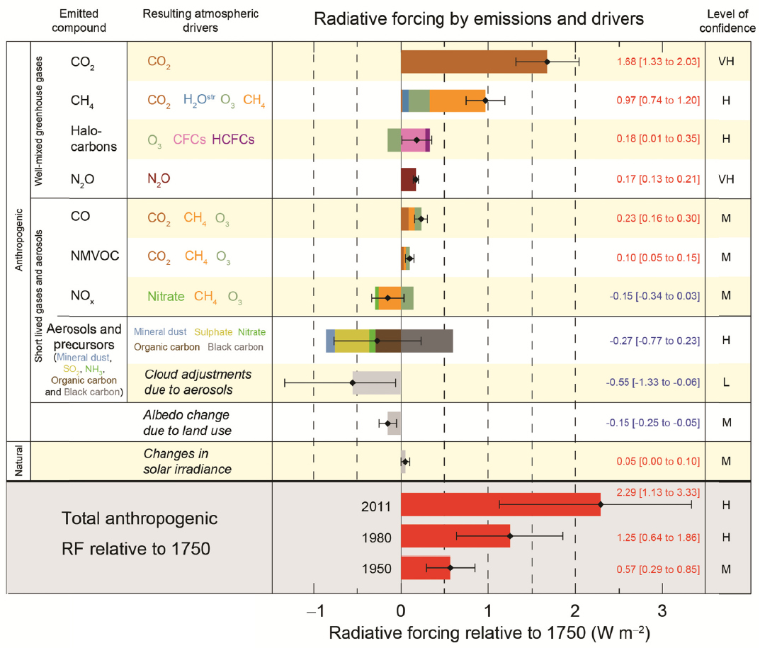
One of the most significant and uncertain aspects of climate change projections is the impact of aerosols on the climate system. Observed global warming from the increase in greenhouse gases may have been and continue to be reduced by aerosol effects. Aerosols influence the climate most directly by increasing the amount of sunlight that is reflected back to space and indirectly through their interactions with clouds. Small changes in cloud cover, thickness, altitude, and cloud particle size and type (liquid versus ice) affect the Earth’s radiative balance significantly, but these complex processes are incompletely captured in climate models (Rosenfeld et al., 2014). Aerosol effects are the largest uncertainty in the human (anthropogenic) radiative forcing of the climate system. Thus there remain significant uncertainties in estimating radiative forcing caused by human activities, leading to a large range in projections of future global warming (Figure 1).
Advancements have been made in recent years in understanding the complex processes and atmospheric interactions involved when aerosols interact with surrounding clouds, but further progress has been hindered by limited observations and coarse resolution climate models. There are a vast range of scales of cloud and aerosol properties and they are significantly smaller than those resolved in climate models (IPCC, 2013).
In light of this, the IC asked the National Academies of Sciences, Engineering, and Medicine to appoint a committee to plan a workshop to determine the usefulness of data from classified observing systems to advance understanding of cloud and aerosol interactions. Such an improved understanding could lead to a more accurate representation of cloud and aerosols in climate models, reducing the uncertainty of climate projections.
In her opening remarks, committee chair Pamela Emch, Northrop Grumman Aerospace Systems, noted that the committee was tasked to plan a workshop to address the following questions:
- How could the data from classified observing systems be utilized to advance understanding of aerosol-cloud-precipitation interactions?
- What are the potential contributions to climate modeling?
- What follow-on scientific research could render such improvements using classified observing system data?
The committee1 planned and organized two workshops (one unclassified and one classified), selected and invited speakers and discussants, and moderated the discussions.
The unclassified workshop was held June 24-25, 2015, in Irvine, California, immediately following the Sackler Colloquium on Improving Our Fundamental Understanding of the Role of Aerosol-Cloud Interactions in the Climate System to leverage participation from scientists who did not hold the appropriate clearances (Seinfeld et al., 2016; see Appendix B). The primary goal of this workshop was to inform the committee’s planning of the classified workshop. Participants discussed current and planned, non-proprietary and unclassified satellite observations of aerosols, clouds and precipitation. They identified gaps that exist in the knowledge as well as observations or data that may be useful in understanding cloud and aerosol interactions. A full recap of the discussions at this workshop is included in Appendix C.
The classified workshop was held September 28-30, 2015, in Washington, DC. Its main goal was to foster interactions with scientists from both the civil and intelligence communities and determine the
__________________
1 Some members of the planning committee already held the required clearances to participate in the classified workshop, some obtained a clearance after being appointed to the committee, and others did not receive a clearance and participated in only the unclassified meetings.
SOURCE: IPCC, 2013.
usefulness of classified observing systems to advance understanding of cloud and aerosol interactions. The workshop agenda is included in Appendix D.2
The presentations and discussions that took place at the classified workshop are described in these proceedings.3 This abbreviated version of a classified report does not step through the classified workshop agenda topics in chronological order; rather it summarizes the workshop topics thematically. First, the scientific context for the workshop (including civilian observing gaps and challenges) is discussed. Next, the proceedings discuss cloud and aerosol processes and parameters that could be potentially estimated with the IC sensors. Finally, the proceedings provide strategies for and limitations in leveraging the classified data.
__________________
2 A participant list for this workshop is not available.
3 These proceedings have been prepared by the workshop rapporteur as a factual summary of what occurred at the classified workshop. The planning committee’s role was limited to planning and convening the workshop. The views contained in the report are those of individual workshop participants and do not necessarily represent the views of all workshop participants, the planning committee, or the National Academies of Sciences, Engineering, and Medicine.
The primary audience of the classified report is IC scientists who are looking to work with leading experts in the civil science community to identify the most promising applications of classified assets to improve representation of clouds and aerosols in climate models. A secondary audience (of this abbreviated version of the classified report) is the civilian scientific community who could consider how potential algorithm improvements might be incorporated into climate models.
PERSPECTIVES FROM THE SPONSOR AND OFFICE OF SCIENCE AND TECHNOLOGY POLICY (OSTP)
The primary goal of this activity is to consider the usefulness of the IC data as is or in some modified way. Although there are several limitations to utilizing the data, the workshop is a first step review of what is possible. Some potential options for utilizing the data if they are not declassified include collecting data and then processing them into a form that is declassified, bringing scientists into a classified setting to use classified data, or a combination of these. Such programs are also a good opportunity to facilitate exchange of information between different agencies.
A related effort that utilized classified data was the Measurements of Earth Data for Environmental Analysis (MEDEA) program. It was initiated in 1994 to create a team of cleared civilian scientists outside of government, who were extensively briefed on classified observing systems, and then were called upon to advise the IC and the White House on environmental issues. MEDEA scientists utilized classified data to advance science on the civilian side. For example, this program was instrumental in the release of physical oceanographic data collected by the Navy as well as older imagery from fiducial sites4 in the Arctic.
Matthew Heavner, OSTP, noted that the timing of the workshop is excellent because of President Obama’s increased visibility and interest in climate-related activities. For example, the President released a Joint Presidential Statement on Climate Change with China (2014); highlighted the implications of climate change on national security in his commencement speech to the Coast Guard (2015); addressed the 2015 Conference on Global Leadership in the Arctic: Cooperation, Innovation, Engagement, and Resilience (GLACIER); and will be participating in the 2015 United Nations Climate Change Conference (COP21) meetings. Dr. Heavner also pointed out that from a national security point of view, the impact of clouds and aerosols on the hydrologic cycle could result in regional instability.
SCIENTIFIC CONTEXT FOR THE WORKSHOP
Processes and Parameters to Advance Understanding
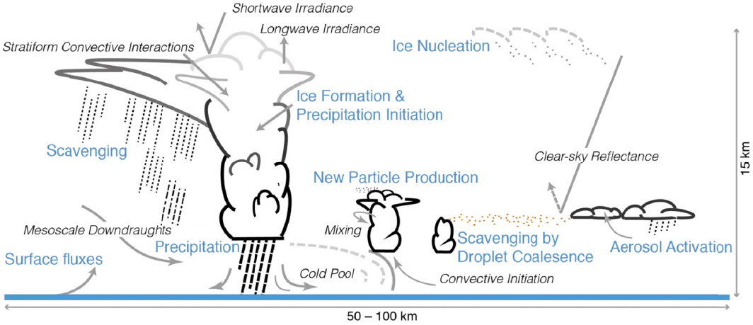
Committee member Michael Prather, University of California, Irvine, gave an overview of specific processes and relationships related to cloud and aerosol interactions. He emphasized the challenge of studying clouds and aerosols from space due to the vast range in size and forms of the particles and droplets (Figure 2). For example, clouds consist of water vapor, liquid droplets, ice particles, graupel (mixed) and range in size from 8-12 μm radius (liquid clouds), 50 μm radius (some cirrus, drizzle), and up to 1 mm (rain). Furthermore, aerosols come in many sizes and composition (e.g., sea salt, dust, sulfate, nitrate, organic, bacteria, fungal spores, and pollen), and range in size from 3-5 μm to more than 10 μm).
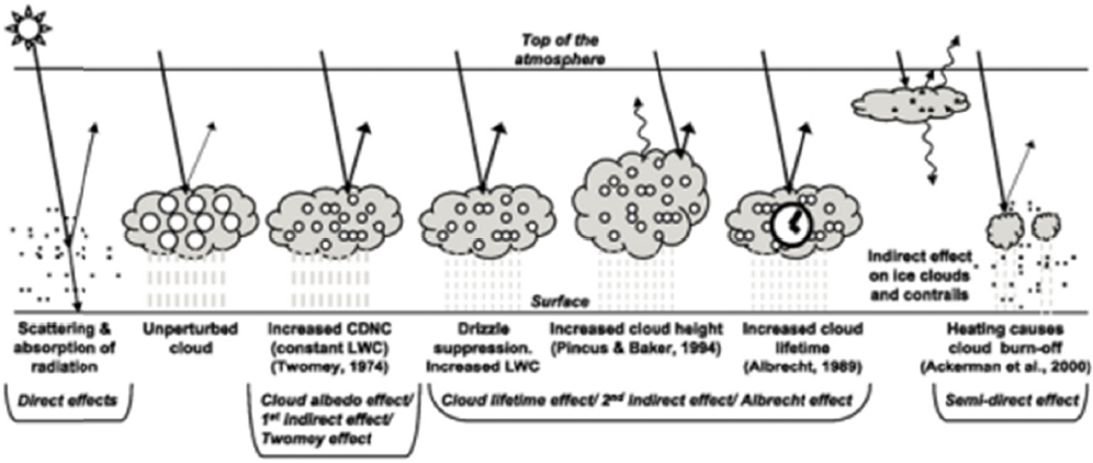
Dr. Prather noted that the processes involved are dynamic, not static (Figure 3). For example, the effective radius of droplets affects the albedo of liquid water clouds, whereas the size and shape of ice
__________________
4 Under MEDEA auspices, the global “fiducials” program was established whereby participating scientists could request collection of classified images at environmentally sensitive locations around the globe. The term “fiducials” refers to the fact that the classified images were to be kept “in trust” in classified archives, with the eventual goal of declassification and release to the broader scientific community for research purposes.
SOURCE: Boucher et al., 2013.
affects the albedo of ice water clouds. Furthermore, given that cloud liquid droplets and ice cloud particles vary greatly in size, it is crucial to know the effective radius and column amount. Ice shape and asymmetry factor are also important properties. Aerosols vary in size (and shape for some) and have different chemical composition and radiative properties. In addition to effective radius and column amount, it is also important to know if there are different mode distributions. Other aerosol characteristics that are useful to know include:
- Is the aerosol absorbing?
- Is the aerosol hydrophilic or hydrophobic?
- Does the aerosol form cloud drops?
- Is the aerosol an ice nucleus?
- Was the aerosol caused by human pollution?
In her presentation, committee member Sonia Kreidenweis, Colorado State University, noted that there is a mismatch between necessary measurements to understand processes, and measurement capabilities from the existing civil platforms. For example, for aerosol properties, the following parameters need to be measured to test understanding: cloud condensation nuclei (CCN) number concentrations, ice nucleating particle (INP) number concentrations, aerosol composition, and particle size distribution. However, current capabilities are limited to aerosol optical depth (AOD), extinction profile, whether a particle is fine or course, and composition proxies. Dr. Kreidenweis noted that AOD is often used to estimate but does not always provide an accurate estimate of number concentration. To get at the microphysics, scientists need to know droplet and/or aerosol number concentration, not total-column values.
Necessary measurements and current capabilities are also mismatched for warm and cold cloud properties, said Dr. Kreidenweis. For warm cloud properties, the following parameters need to be retrieved: droplet number concentrations, droplet size distributions, vertically resolved liquid water content (LWC), drizzle, rain drop size distribution (DSD), and precipitation and evaporation rates. However, only the following properties can currently be derived with civilian satellites: cloud reflectivity, cloud optical depth, cloud top height, precipitation retrievals (heavy/light), and cloud fraction. A similar mismatch also occurs for cold cloud properties. Estimates of ice crystal number concentrations, ice particle size distributions (by type),
SOURCE: Foster et al., 2007; modified from Haywood and Boucher, 2000.
vertically resolved (ice water content [IWC]; by type), and precipitation/evaporation rate would all advance understanding. Currently, properties that can be derived from satellites are limited to cloud reflectivity, cloud optical depth, cloud top height, some microphysics retrievals, and some phase discrimination.
There are several additional observational needs for improving understanding, said Dr. Kreidenweis. Increased spatial resolution for AOD would allow for cloud removal, possibly resulting in improved correction for relative humidity. Increased resolution would also allow for retrievals closer to clouds, which is relevant for studying their interactions with aerosols. Satellite instrumentation with additional wavelengths would enable more properties to be derived (e.g., particle size) and potentially allow scientists to estimate shapes of particles (e.g., spherical versus irregular). Satellites in a geostationary orbit (GEO), due to the capability to view a particular location over a long period of time, could observe the evolution of aerosol and cloud formation. Vertically resolved observations place particles in the correct layers, which would allow for more understanding of their impact on cloud development and aerosol transport. Absorption measurements from satellites would help identify particle type and direct effects. Concurrent relative humidity measurements would allow for correction to dry AOD.
Dr. Kreidenweis also discussed several hypothesized impacts of aerosols on clouds and noted that such hypotheses are difficult to test using civil observations. For example, it is hypothesized that aerosols impact cloud reflectivity, but scientists are limited to calculating statistical changes, correlated to aerosols in the context of an inferred environment to test this impact. It is also hypothesized that aerosols modify cloud lifetime, but this is only possible to test using a geostationary satellite and current civil geostationary satellite observations do not have sufficient spatial resolution to detect these sorts of processes. Testing the hypothesis that aerosols inhibit drizzle is challenging because changes in clouds can be due to other environmental factors in addition to aerosols. However, advanced radar could be used to show that aerosols lead to changes in phase/hydrometeor development. Anvil properties and extent changes may also be due to interactions with aerosols, but scientists are only able to estimate size changes because such properties are challenging to retrieve with satellites. Dr. Kreidenweis also noted improved aerosol fields are required to test all of these hypothesized impacts on clouds. Box 1 lists key processes and properties that were suggested by various participants as necessary to advance understanding of cloud and aerosol interactions.
Current Capabilities of the Civilian Satellite System: Gaps and Challenges
Committee member Michael Prather, University of California, Irvine, provided an overview of civilian satellite capabilities for deriving cloud and aerosol data (see Appendix E for more detailed satellite specifications). Dr. Prather discussed civilian satellites that have been utilized to study clouds and aerosols:
- AVHRR (The Advanced Very High Resolution Radiometer)5 has a 1.9 km spatial resolution and some spectral resolution (4-6 channels). It measures intensity (radiance) and can retrieve AOD and some size information.
- MODIS (MODerate resolution Imaging Spectroradiometer)6 data can be used to retrieve many more cloud and aerosol parameters than AVHRR data, in part because of the broadband spectral limitations of AVHRR as compared to MODIS (36 channels), and the placement of spectral channels with retrieval objectives in mind. Its spatial resolution is 250 m (day) and 1,000 m (night) and it has a 2,330 km swath. It also measures intensity and retrieves aerosol loading7 and some
__________________
5http://noaasis.noaa.gov/NOAASIS/ml/avhrr.html
6 http://modis.gscf.nasa.gov
7 Atmospheric aerosol loading is suspensions of solids and/or liquid particles in the air and is usually measured by the mass concentration of aerosol particles or by an optical measure, AOD.
-
absorption information. MISR (Multi-angle Imaging Spectroradiometer)8 measures intensity with angular signature (9 angled cameras) and some spectral resolution (4 bands). It has a spatial resolution between 275 m and 1 km. It can retrieve loading, shape, size, and some absorption and height information.
- CALIPSO (Cloud-Aerosol Lidar and Infrared Pathfinder Satellite Observation)9 includes an active Lidar instrument with passive infrared (IR) and visible imagers. It can retrieve range-resolved AOD, cirrus optical depth, and extinction and backscatter coefficients upward from the lower troposphere.
- CloudSat10 is a 94-GHz (mm) nadir-looking radar sensitive to typical water clouds (10 μm), but more sensitive to cirrus or drizzle (50 μm). It can retrieve ice water path and cloud fraction. It has a vertical resolution of 500 m, a cross-track resolution of 1.4 km and an along-track resolution of 2.5 km.
- POLarization and Directionality of the Earth's Reflectances (POLDER)11 measures intensity and polarization with angular spectral signature, limited by accuracy and pixel spatial resolution. It can retrieve loading and an array of particle properties. It has a 2,400 km swath and a spatial resolution of 6.5 km.
- ADM-Aeolus (Atmospheric Dynamics Mission-Aeolus)12 is a European Space Agency (ESA) satellite expected to launch in 2017. It will have a sun synchronous orbit at an altitude of 400 km with a Doppler wind lidar to probe the lowermost 30 km of the atmosphere to measure the winds. It also will have a 355 nm Lidar with a high-spectral resolution receiver and separate detection of molecular and particle backscatter.
- Landsat13 8 has been used to improve aerosol retrieval algorithms. It has a 16-day repeat and a spatial resolution of 15-30 m.
- Commercial satellites such as Quickbird, WorldView, and IKONOS have all been used to study aerosols.
- SEVIRI (Spinning Enhanced Visible and InfraRed Imager),14 a second generation geostationary orbit (GEO) satellite from the European Union Meteosat, has been used to retrieve AOD.
Dr. Prather also discussed the algorithm, PMAp (Polar Multi-sensor Aerosol Properties), which utilizes data from two platforms and three sensors—GOME2, AVHRR, and IASI—to retrieve aerosol and volcanic ash (from IR channels) properties.
Dr. Prather presented two slides courtesy of Ralph Kahn, National Aeronautics and Space Administration (NASA). The first slide summarized satellite capabilities for studying aerosol cloud interactions:
- Polar orbiting imagers provide infrequent15 global coverage
- Geostationary platforms offer high temporal resolution
- Multi-angle imagers offer aerosol plume height and cloud-top mapping
- Passive instruments can retrieve total-column aerosol amount (i.e., AOD)
- Active instruments determine aerosol and some cloud vertical structure
- Ultraviolet (UV) imagers and active sensors can detect aerosols above clouds
- Multi-angle, spectral, polarized imagers obtain some aerosol type information
- Active sensors can obtain some aerosol type information, day and night
- Satellite trace-gas retrievals offer clues about aerosol type
__________________
9http://www-calipso.larc.nasa.gov
10http://www.nasa.gov/mission_pages/cloudsat/main/index.html
11https://polder-mission.cnes.fr
12http://www.esa.int/Our_Activities/Observing_the_Earth/The_Living_Planet_Programme/Earth_Explorers/ADMAeolus/ESA_s_wind_mission
14 http://eumesat.int/website/home/Satellites/CurrentSatellites/Meteosat/MeteosatDesign/index.html
15 Polar imagers typically view each point on the earth twice per day.
- Vis-IR imagers can retrieve cloud phase, LWP, and some other cloud properties
The second slide summarized satellite limitations:
- Polar orbiters provide snapshots only
- Difficult to probe cloud base
- Typically hundreds of meters or poorer horizontal resolution
- Passive instruments (imagers) offer little vertical information
- Active instruments (e.g., lidar) offer little spatial coverage
- Little information about aerosol particle microphysical properties
- Bigger issues retrieving aerosols in the presence of clouds
- Cloud property retrievals can be aliased by the presence of aerosols
Dr. Prather discussed additional satellite limitations. In many satellite images, clouds appear to be brightening and “bluing” and aerosols appear brighter and larger near clouds. The closer aerosols are to a cloud, the larger the increases of AOD, which is due to undetected cloud contamination, three-dimensional radiative effects, and humidification on aerosol size. Additionally, for ice water clouds, MODIS-like retrievals of optical thickness and effective radius are biased because of an unknown asymmetry parameter.
Climate Modeling Considerations
Committee member Steven Ghan, Pacific Northwest National Laboratory (PNNL), presented research on constraining effective radiative forcing by cloud-aerosol interactions in climate models. He said that in order to be confident that the net result is correct for the right reasons, all of the relevant cloud-aerosol interactions in the models should be constrained.
Dr. Ghan noted that a “chain of relationships” drives aerosol effects on cloud radiative forcing. These relationships are not always a single process (Figure 4). In many cases, existing modeling frameworks reflect only a partial set of known cloud-aerosol interaction processes. In some sense, the models only produce partial results by illustrating a result of a particular process, with all other processes being held constant.
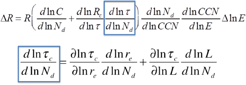
SOURCE: Ghan, 2015.
In order to make progress on quantifying aerosol-cloud interactions for climate assessments, Dr. Ghan believes it is important to:
- develop metrics that relate anthropogenic change to present day observables,
- use measurements where and when aerosol has changed, and
- apply measurements to cloud regimes.
For example, aerosols measurements taken from locations where aerosols have increased (e.g., China) or decreased (e.g., Europe) would allow scientists to study how the change in aerosol load impacted cloud regimes.
Dr. Ghan noted that diversity in estimated effective radiative forcing through aerosol effects on clouds is driven by diversity in several factors. Constraints on anthropogenic aerosol effects are needed for each factor. Constraining sensitivities using data from present day variability is often insufficient to constrain anthropogenic aerosol effects. He concluded that new present day metrics are needed. Regional trends for selected periods could be helpful. Global satellite data availability limits trend analysis of factors to 2002 and later.
OVERVIEW OF CLASSIFIED OBSERVING SYSTEMS
During the workshop, representatives from the IC briefed the cleared civil scientists on several classified observing systems.
POTENTIAL APPLICATIONS OF CLASSIFIED OBSERVING SYSTEMS FOR CLOUDS AND AEROSOLS
Workshop participants discussed several processes and properties related to cloud and aerosols that could be estimated utilizing some of the unique characteristics of the classified sensors (Box 2).
STRATEGIES FOR LEVERAGING IC SENSOR DATA
During the workshop, several possible strategies and opportunities for leveraging the IC data were suggested (Box 3). Some strategies use data already available in IC archives. In other cases, the civil science community would want to work with the IC to guide new data collection that could address science questions related to clouds and aerosols.
One strategy for utilizing the data is co-location of IC sensors with other assets. Co-collects may help scientists determine the statistical nature of smaller scale processes that can be observed by instruments that resolve different variables at the same time. Such an approach is particularly valuable if there is covariance among the variables that would then allow scientists to infer unobserved parameters from more readily available observations of other variables.
Data from the IC sensors could be coordinated with co-collects with data from field campaigns (e.g., Southern Ocean Field Campaign) or civilian ground-based remote sensing (e.g., AERONET16) and in situ instruments (e.g., the Department of Energy’s Atmospheric Radiation Measurement Program [DOE’s ARM] sites), said some participants. Field campaigns, and some in situ observing stations, are designed to study environmental processes and sometimes to assist with satellite calibration and validation, which would benefit both the civil and IC communities. However, some participants cautioned that it would be a significant challenge to have classified communication in the field.
Another opportunity is to co-collect with space-based civilian sensors (e.g., VIIRS, MODIS, MISR, CERES). Some participants also said it would be useful to co-collect data from classified satellites with other classified satellites.
Another strategy discussed by many participants is to identify particular locations and associated phenomena that would be useful for detailed analysis. Such locations might be selected because they either have interesting phenomena or are data sparse in the civilian community.
Specific priority locations suggested by some participants include:
- Indian monsoon (Ganges River valley) because it occurs in a high aerosol environment.
- Straits of Malacca because it has both high aerosol loading and strong storms.
- Locations in the Eastern Hemisphere because there is greater opportunity for co-collects.
- Darwin, Australia, where a thundercloud (named “Hector”) forms there regularly each afternoon from September to March.
- Venezuela’s Lake Maracaibo, which also has regular thundercloud formation each day.
- ARM sites such as Barrow, Alaska, and the Azores.
__________________
16 The AERONET (Aerosol Robotic Network) program is a federation of ground-based remote sensing aerosols networks established by NASA and PHOTONS (PHOtometrie pour le Traitement Operationnel de Normalisation Satellitaire). It provides a long-term, continuous, and readily accessible public domain database of aerosol optical, microphysical, and radiative properties for aerosol research and characterization, validation of satellite retrievals, and synergism with other databases.
Follow-on research ideas to improve utilization of the classified data were discussed briefly by some participants. One idea is to study implications of high resolution retrievals to gain a better understanding of what is really “seen.” For example, smaller grid boxes would result in more boxes that are completely clear and others that are completely cloud covered. This impacts how much of the cloud is reacting with the rest of the atmosphere in the retrievals. Another idea is to explore how an individual cloud is identified (e.g., optically or thermodynamically).
Pilot Projects
Based on the workshop discussions, four potential pilot projects were identified by various participants to test the usefulness of the IC data in advancing understanding of cloud and aerosol interactions. Scientists could be cleared to work on these projects on the classified side to test the utility on a small scale. Some government scientists (e.g., Naval Research Laboratory [NRL]) have the capacity to work with classified data already, and even if their research were not declassified it would still benefit the IC and the scientists involved, said some participants. This would facilitate pilot projects, and improve their chance of success. If the pilot proves promising, then the case could be made to declassify or downgrade the data for release. It was noted by several participants that even projects that fall short of their scientific goals could provide useful lessons for the IC to improve data collection and processing.
Workshop participants divided into small groups to discuss the pilot projects in more detail. For each project, groups discussed the relevant IC sensors, scientific value, IC/Department of Defense (DoD) value, civil applications, barriers and limitations (scientific, technical, and policy), opportunities to coordinate with other assets (IC, civilian, and commercial), and future scientific research to advance utility.
Civilian and IC Collaboration
Many participants said that there are potential co-benefits from the partnership of civilian scientists and the IC community. One benefit is the co-development of algorithms. New algorithms and models (e.g., physics-based retrievals of plumes) developed on the civilian side could be shared with the IC for their classified systems. This also would potentially lead to shared observing system simulation experiments (OSSEs) and the development of retrieval assimilations and validation.
Some participants raised the idea of a potential IC/NRL collaboration to improve climate and weather models. Full assimilation of meteorological and aerosols data into the models would be ideal (e.g., fluxes, what is going into clouds, where they are flowing, all at high resolution), said participants. This product could be released and used by civilians, without releasing classified information about the satellite that did the collection. Committee member Dr. Jeffrey Reid, NRL, said that FNMOC (Fleet Numerical Meteorology and Oceanography Center)17 and NRL already have these types of capabilities for their models.
Calibration techniques honed for civilian sensors could be applied to IC sensors, many participants said. An example is the research and development partnership between the IC and NASA Goddard Space Flight Center (GSFC). One of the goals of this partnership is to utilize data from unclassified sensors (remote and in situ) and apply techniques from NASA to improve calibration of the IC sensors. Another example discussed by some participants is utilizing coincident observations with MODIS and VIIRS to help the IC community with calibration. Such coincident observations could also benefit the civilian community by advancing understanding of clouds and aerosols.
__________________
17 FNMOC utilizes high performance computing at all levels of classification to provide worldwide meteorology and oceanography support to the U.S. Navy.
SCIENTIFIC AND TECHNICAL LIMITATIONS
Although there are many potential benefits in utilizing the IC data, participants highlighted several technical and scientific limitations in leveraging the IC data. One major limitation is calibration accuracy, which is critical for data usability for environmental applications. Other limitations include collection constraints, self-emission issues, lack of vertical information, and data processing (i.e., models will likely need to be modified to use some of the data). Additionally, there are limitations due to the mismatch between mission targets for the classified observing systems (e.g., missile launches, nighttime activity, etc.) and retrievals needed for advancing understanding of clouds and aerosols.
POLICY-RELATED LIMITATIONS
In addition to the scientific and technical challenges, there are several policy-related limitations in leveraging IC data. The biggest limitation, said many participants, is data access. Most civilian scientists will not have access to classified data, and the few that do will have difficulty in finding, navigating, and citing the data. They would likely find it difficult to publish study results that utilize the classified data because the results would not meet the requirement for reproducibility. Methods need to be developed to enable easy identification and access, said many participants. Merging and integrating data from classified and civilian systems could provide significant value, but would be a major challenge that requires significant financial and human resources.
One possible solution suggested by some workshop participants, would be to have civilian cloud and aerosol experts potentially influence future classified systems to consider environmental applications in their design and factor in a pathway to provide data from these future classified systems into the unclassified realm.
Metadata
Another policy-related limitation discussed at the workshop is the lack of metadata available about the IC data. Dr. Reid gave a presentation on metadata in the context of utilizing the IC data to study clouds and aerosols. Metadata describes the nature and context of a dataset such that the dataset can be used for a specific application. He said that scientists who will utilize the IC data will need metadata on the sensor, on how the data were processed to produce downstream products, and the environment as a whole. He said the following types of metadata are needed:
- Sensor: Characteristics of the sensor and onboard processing, including field of view, wavelength bands and spectral response function, saturation, sampling, gain, coregistration, point spread function, and calibration cycle.
- Ephemeris: What, when, where, and geometries of how the data were collected.
- Environmental state: State vector of the atmosphere and surface; this information can be derived from the sensor or taken from elsewhere.
- Atmospheric correction: How the correction was done, including whether it corrected for molecular contributions.
- Downstream products: What process was used to create the products, including the assumptions, uncertainties, and intermediate products.
Dr. Reid noted that declassifying metadata is a significant challenge because some of the required information is highly classified. Also, in some cases, even if the metadata were to remain classified, some of these details could be determined from analysis of the data, making it difficult to declassify the data themselves. He noted that some common metadata for civilian applications can be bypassed; however,
civilian science is grounded in transparency for reproducibility, and scientists would likely have a difficult time using data that lacks appropriate metadata in their peer-reviewed research.
Dr. Reid also noted that there are several types of biases that need to be described in the metadata:
- Method Bias: Biases related to shortcomings in the method itself.
- Calibration Bias: Drift in the instrument response characteristics that cannot be explained.
- Sampling and Contextual Bias: Biases related to where the retrieval is performed or contextually related uncertainty in a scene. This leads to a skewed data population relative to what is thought to have been collected.
- Aggregation and Data Reduction Bias: Loss of required information during conversion to higher level products or during analysis.
- Cognitive Bias: The investigators misinterpret, withhold, or frame data or results without consideration of the full nature of the data.
- Other considerations for multi-sensor work:
- Correlated error: “Independent” products that share similar biases.
- Tautology: Circular reasoning or treating non-independent data as independent during data reduction.
Dr. Reid offered some considerations for utilizing the IC data. Given that it is possible to determine the orbit, location, and a time from an image, he said it would be beneficial to IC data users, if the IC could clearly identify the type of information that must remain classified.
CONCLUSION
Although several limitations and challenges were identified in utilizing the classified data, some participants were optimistic that the IC and civilian scientists could come together to find creative ways to leverage the data for advancing understanding in cloud and aerosol interactions. Many participants said that the four pilot projects would be an excellent first step forward to test the utility of the data, and any pilots that prove promising could potentially provide rationale for declassifying or downgrading the data for release allowing for wider use.


