


Below is the uncorrected machine-read text of this chapter, intended to provide our own search engines and external engines with highly rich, chapter-representative searchable text of each book. Because it is UNCORRECTED material, please consider the following text as a useful but insufficient proxy for the authoritative book pages.
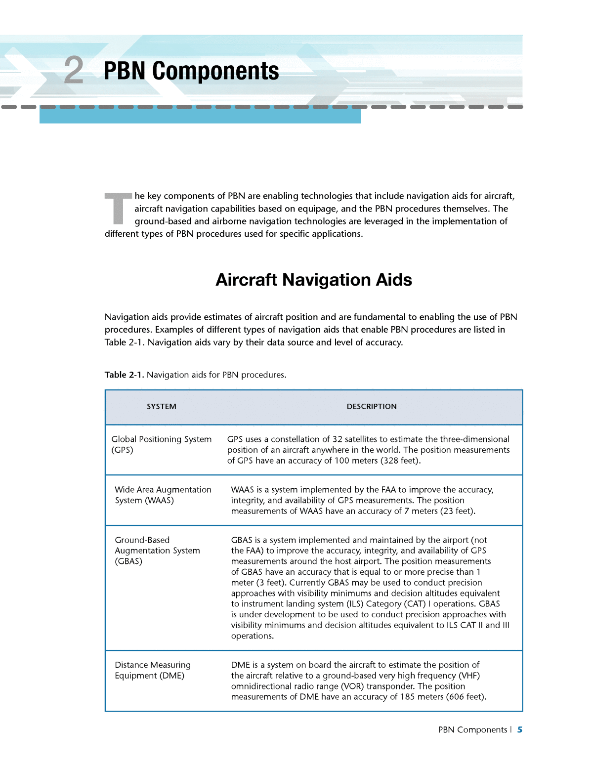
PBN Components | 5 2 PBN Components T he key components of PBN are enabling technologies that include navigation aids for aircraft, aircraft navigation capabilities based on equipage, and the PBN procedures themselves. The ground-based and airborne navigation technologies are leveraged in the implementation of different types of PBN procedures used for specific applications. Aircraft Navigation Aids Navigation aids provide estimates of aircraft position and are fundamental to enabling the use of PBN procedures. Examples of different types of navigation aids that enable PBN procedures are listed in Table 2-1. Navigation aids vary by their data source and level of accuracy. Table 2-1. Navigation aids for PBN procedures. SYSTEM DESCRIPTION Global Positioning System (GPS) GPS uses a constellation of 32 satellites to estimate the three-dimensional position of an aircraft anywhere in the world. The position measurements of GPS have an accuracy of 100 meters (328 feet). Wide Area Augmentation System (WAAS) WAAS is a system implemented by the FAA to improve the accuracy, integrity, and availability of GPS measurements. The position measurements of WAAS have an accuracy of 7 meters (23 feet). Ground-Based Augmentation System (GBAS) GBAS is a system implemented and maintained by the airport (not the FAA) to improve the accuracy, integrity, and availability of GPS measurements around the host airport. The position measurements of GBAS have an accuracy that is equal to or more precise than 1 meter (3 feet). Currently GBAS may be used to conduct precision approaches with visibility minimums and decision altitudes equivalent to instrument landing system (ILS) Category (CAT) I operations. GBAS is under development to be used to conduct precision approaches with visibility minimums and decision altitudes equivalent to ILS CAT II and III operations. Distance Measuring Equipment (DME) DME is a system on board the aircraft to estimate the position of the aircraft relative to a ground-based very high frequency (VHF) omnidirectional radio range (VOR) transponder. The position measurements of DME have an accuracy of 185 meters (606 feet).
6 | UNDERSTANDING THE AIRPORTâS ROLE IN PERFORMANCE-BASED NAVIGATION SYSTEM DESCRIPTION Inertial Reference Unit (IRU) IRU is a system on board the aircraft to estimate the position of the aircraft via cumulative measurements of aircraft motion from a given initial position. The position measurements of an IRU may have an accuracy of 400 meters (1,312 feet). However, the accuracy depends on the accuracy of the estimated initial position of the aircraft, the âdrift rateâ of the IRU, and the ability of the IRU to update the cumulative position estimates. Flight Management System (FMS) An FMS is a specialized computer system that automates a wide variety of in-flight tasks, reducing the workload on the flight crew to the point that modern aircraft no longer carry flight engineers or navigators. A primary function is in-flight management of the flight plan. Using navigation aids to determine the aircraftâs position, the FMS can guide the aircraft along the flight plan. The FMS is normally controlled through an interface in the cockpit of the aircraft that incorporates a small screen and keyboard or touchscreen. The FMS sends the flight plan for presentation to the flight crew on the instrument display system in the cockpit of the aircraft. Flight Management Computer (FMC) The FMC manages and processes the components of the FMS including navigation radio receivers; inertial reference systems; air data systems; navigation, flight, and instrument displays; flight control systems; the engine and fuel system; and the data link. The FMC provides the primary navigation, flight planning, and optimized terminal routes and en route guidance for the aircraft and is typically composed of interrelated functions such as navigation, flight planning, trajectory prediction, performance computations, and guidance. A fundamental component to the FMC is the navigation database (NDB). The NDB contains all the information required to create a flight plan and to process that plan when airborne. The NDB contains all the fixes, waypoints, navigation aids, jet routes, arrival and departure routes, airport information, and other data necessary for navigation. WAAS and GBAS improve the precision of GPS position measurements within a certain radius of cover- age. They enhance the ability of the aircraft to conduct RNAV within that area of coverage. GBAS is in- stalled at an airport, with the airport and the FAA sharing the costs of installing this system. WAAS and GBAS support precision instrument approach procedures to improve access to the airport in reduced visibility conditions. Aircraft Navigation Capabilities The particular PBN procedures an aircraft may fly are first and foremost determined by the navigation capabilities of the aircraft. Key aircraft navigation capabilities required for PBN are listed in Table 2-2. RNAV and RNP capabilities are the cornerstones of the FAA PBN program. Table 2-1. Continued
PBN Components | 7 Table 2-2. Navigation capabilities for PBN procedures. CAPABILITY DESCRIPTION Area Navigation (RNAV) RNAV is a method of navigation that permits aircraft operations on a desired flight path within the coverage of ground- or space-based navigational aids, within the limits of aircraft-contained navigational systems, or within a combination of these systems. RNAV is enabled through the use of a flight management system (FMS), flight management computer (FMC), or global positioning system (GPS) receiver on the aircraft. An RNAV 1 flight procedure requires the aircraft to sustain a lateral accuracy of +/- 1 nautical mile within the centerline of the route of flight for 95% of the flight time along the route. RNAV Lateral Navigation (LNAV) LNAV is the aircraft navigation capability that performs lateral guidance of the aircraft along the flight procedure. LNAV is achievable with an FMS, FMC, or GPS receiver on the aircraft. RNAV Vertical Navigation (VNAV) VNAV is the aircraft navigation capability that performs vertical guidance of the aircraft along the flight procedure. VNAV provides guidance to the aircraft according to the detailed flight path computed by the FMS, FMC or GPS receiver on board the aircraft. VNAV may conduct vertical guidance of the aircraft during the takeoff, climb, cruise, descent, approach, and missed approach phases of flight. The vertical profile of the planned flight path satisfies the altitude and speed restrictions of the flight procedure, and attempts to maximize flight efficiency according to the performance and weight of the aircraft, and the winds and weather that the aircraft is estimated to encounter. VNAV which uses barometric pressure of the atmosphere for altitude measurement and vertical guidance is referred to as Baro-VNAV. RNAV Localizer Performance (LP) RNAV LP approach procedures use position measurements from the wide area augmentation system (WAAS) to perform lateral guidance. They are similar to approach procedures that rely on the localizer of an instrument landing system (ILS). RNAV Localizer Performance with Vertical Guidance (LPV) RNAV LPV approach procedures use position measurements from WAAS to perform lateral and vertical guidance. They are similar to approach procedures that rely on the localizer and glide slope of an ILS. Required Navigation Performance (RNP) RNP uses the RNAV capability of the aircraft and uses a system on board the aircraft that monitors the actual navigation performance (ANP) of the aircraft. The RNP system alerts the flight crew if the ANP does not meet the RNP during operation. RNP uses position measurements from GPS for lateral navigation and Baro-VNAV for vertical navigation. An RNP 1 flight procedure requires the aircraft to sustain lateral navigation accuracy of 1 nautical mile for 95% of the flight time along the route.
8 | UNDERSTANDING THE AIRPORTâS ROLE IN PERFORMANCE-BASED NAVIGATION CAPABILITY DESCRIPTION RNP Authorization Required (AR) An RNP AR flight procedure requires advanced aircraft navigation capabilities and crew procedures to conduct the flight procedure. Advanced capabilities may include radius-to-fix (RF) navigation capability to fly a constant-radius, semi-circular turn about a center fix, and more precise RNP values that are lower than the standard RNP values in various segments of the procedure. Advanced RNP Advanced RNP is an aircraft certification specific to a bundle of FMS features including terminal RF legs, scalable/selectable RNP, parallel offset routes in the en route environment, RF transitions in the en route environment, time of arrival control, and RNP holding. Advanced RNP aims to streamline aircraft certification and operator approval to use the advanced FMS functions. Advanced RNP has not yet been implemented by FAA but is likely to emerge within the 10-year planning horizon to enable more efficient en route transition, arrival and departure routes, and trajectory-based operations. Types of Procedures The types of flight procedures utilizing PBN vary based on specific applications. Types of PBN proce- dures in the en route and terminal domains that serve airport arrivals and departures or traffic flows proximate to the airport are listed in Table 2-3. Table 2-3. PBN en route, departure and arrival flight procedures. TYPE DESCRIPTION AIRCRAFT CAPABILITIES Area Navigation (RNAV) 2 Q-routes RNAV 2 Q-routes are routes for high altitudes in the en route airspace 5,486 meters to 13,716 meters (18,000 feet to 45,000 feet above ground jevel AGL). Aircraft fly these procedures using GPS or DME and IRU navigation aids (GPS or DME/ DME/IRU navigation). GPS- or DME/DME/IRU- based RNAV1 RNAV 2 T-routes RNAV 2 T-routes are for general aviation traffic in lower altitudes in busy terminal areas. Aircraft fly these procedures using GPS or DME/DME/IRU navigation. GPS- or DME/DME/IRU- based RNAV Table 2-2. Continued
PBN Components | 9 TYPE DESCRIPTION AIRCRAFT CAPABILITIES RNAV 1 Standard Terminal Arrival Routes (STARs) RNAV 1 STARs are procedures for aircraft arriving to an airport. Aircraft fly these procedures using GPS or DME/DME/IRU navigation. Aircraft use lateral navigation (LNAV) to remain within 1 nautical mile for 95% of the flight time along the procedure. The RNAV 1 STARs may include altitude restrictions at waypoints to provide windows for aircraft to conduct optimized profile descents (OPDs) or altitude restrictions at waypoints to procedurally separate the arrivals from terrain or other traffic in the airspace, and aircraft may use barometric pressure-based vertical navigation (Baro-VNAV) to satisfy these restrictions. RNAV 1 STARs may be designed to connect approach procedures to individual runways of an airport, or may end at a point from which air traffic controllers vector aircraft to the runway or its approach procedure. RNAV 1 STARs are being implemented at most major hub airports in the United States. GPS- or DME/DME/IRU- based RNAV and LNAV, Baro-VNAV RNAV 1 Standard Instrument Departures (SIDs) RNAV 1 SIDs are departure procedures requiring RNAV 1 navigation capability of the aircraft. Aircraft fly these procedures using GPS or DME/ DME/IRU navigation. Aircraft use LNAV to remain within 1 nautical mile for 95% of the flight time along the procedure. RNAV 1 SIDs may include altitude restrictions at waypoints to procedurally separate the departures from other traffic in the airspace or terrain, and aircraft may use Baro- VNAV to satisfy these restrictions. RNAV 1 SIDs may be designed with initial departure paths that begin at individual runways of an airport (RNAV off the ground) and that concentrate aircraft away from noise sensitive areas around the airport. An RNAV 1 SID may be designed to begin at a point away from the airport, thereby requiring air traffic controllers to vector aircraft to the initial waypoint of the procedure. The vectoring may be conducted to disperse aircraft to minimize the concentration of aircraft over particular areas around the airport. Aircraft performance measures such as climb rates are important to consider in the design of RNAV SIDs. GPS- or DME/DME/IRU- based RNAV and LNAV, Baro-VNAV Table 2-3. Continued
10 | UNDERSTANDING THE AIRPORTâS ROLE IN PERFORMANCE-BASED NAVIGATION TYPE DESCRIPTION AIRCRAFT CAPABILITIES Required Navigation Performance (RNP) 1 STARs and SIDs RNP 1 STARs and SIDs may be implemented to meet local needs for procedural separation of airport arrivals or departures from other traffic or obstacles in the airspace. However, there are no existing public criteria for designing such procedures according to monitoring and alerting requirements. RNP STARs and SIDs are not likely to be implemented, particularly in the near-term time frame. GPS- or DME/DME/ IRU-based RNAV and LNAV, Baro-VNAV, RNP monitoring and alerting 1Aircraft conducting RNAV with DME/DME/IRU use DME measurements from at least two VORs, along with the IRU, to estimate aircraft position (Federal Aviation Administration 2011). The various types of PBN SIAPs that might be implemented at an airport to serve one or more runways are presented in Table 2-4. Table 2-4 PBN SIAPs. TYPE DESCRIPTION AIRCRAFT CAPABILITIES Area Navigation (RNAV) Lateral Navigation (LNAV) RNAV LNAV standard instrument approach procedures (SIAPs) are non-precision approach procedures. The aircraft uses the global positioning system (GPS) or the Wide area augmentation system (WAAS) navigation aids and LNAV for lateral guidance along the flight procedure. RNAV LNAV SIAPs can be designed to minimum descent altitudes (MDAs) as low as 76 meters (250 feet) above ground level (AGL). GPS- or WAAS-based RNAV and LNAV RNAV Localizer Performance (LP) LP SIAPs are non-precision approach procedures. The aircraft uses the WAAS navigation aid and LNAV for lateral guidance along the flight procedure. LP SIAPs can be designed to MDAs as low as 76 meters (250 feet) AGL. LP SIAPs are used to replace localizer-only approach procedures for use by general aviation (GA) aircraft. LP SIAPs are typically used where terrain or obstructions do not allow LPV approach procedures. WAAS-based RNAV and LNAV Table 2-3 Continued
PBN Components | 11 Table 2-4 Continued TYPE DESCRIPTION AIRCRAFT CAPABILITIES RNAV Required Navigation Performance (RNP) 0.3 RNAV RNP 0.3 SIAPs are non-precision approach procedures with vertical guidance. Aircraft use GPS navigation, LNAV for lateral guidance, and RNP monitoring and alerting to remain within 0.3 nautical miles of the lateral path of the procedure. Aircraft use Baro-VNAV for vertical guidance. RNAV RNP 0.3 SIAPs can be designed to decision altitudes (DAs) as low as 76 meters (250 feet) AGL. RNAV RNP 0.3 SIAPs may enable approaches to the parallel runways of an airport in reduced visibility conditions. They are typically used by commercial air carriers. They were originally developed as public approaches, with no authorization required. GPS-based RNAV and LNAV, Baro-VNAV, RNP monitoring and alerting RNAV LNAV/ Vertical Navigation (VNAV) RNAV LNAV/VNAV SIAPs are non-precision approach procedures with vertical guidance. Aircraft use GPS navigation, LNAV for lateral guidance, and Baro-VNAV for vertical guidance. RNAV LNAV/VNAV SIAPs enable approaches to the parallel runways of an airport in reduced visibility conditions and can be designed to DAs as low as 76 meters (250 feet) AGL. GPS-based RNAV and LNAV, Baro-VNAV RNAV Localizer Performance with Vertical Guidance (LPV) RNAV LPV SIAPs support approaches in visibility conditions of 805 meters (one-half mile or 2,400 feet) and DAs of 61 meters (200 feet) similar to instrument landing system (ILS) Category (CAT) I operations. Aircraft use WAAS navigation and LNAV with VNAV for lateral and vertical guidance. RNAV LPV SIAPs are primarily for GA aircraft; commercial carriers are generally not equipping their aircraft for these procedures. WAAS-based RNAV, LNAV and VNAV
12 | UNDERSTANDING THE AIRPORTâS ROLE IN PERFORMANCE-BASED NAVIGATION Table 2-4 Continued TYPE DESCRIPTION AIRCRAFT CAPABILITIES RNP Approval Required (AR) RNP AR approaches include unique capabilities that require special aircraft and aircrew authorization similar to ILS CAT II/III operations. RNP AR SIAPs support LNAV precisions down to 0.11 nautical miles. Aircraft use GPS navigation aid, LNAV, and RNP monitoring and alerting for lateral guidance, and may also use radius- to-fix (RF) navigation capability of the aircraft for lateral guidance. The aircraft use baro-VNAV for vertical guidance. RF legs may be included anywhere in the procedure, including the final approach segment. Air crew training, aircraft database validation, and operating procedures are required to conduct AR procedures. RNP AR SIAPs may enable approaches to closely spaced parallel runways in reduced visibility with DAs of 76 meters (250 feet) AGL. GPS-based RNAV, Baro- VNAV, RNP monitoring and alerting, possibly RF navigation Ground Based Augmentation System (GBAS) GBAS SIAPs are intended to provide precision approaches with minimum visibilities and decision altitudes similar to ILS CAT I, II, and III operations. However, GBAS SIAPs are currently only certified for ILS CAT I minimum visibility and DAs. The final approach path is uploaded to the aircraft. The aircraft uses the GBAS navigation aid with LNAV for lateral guidance and VNAV for vertical guidance, and deviations from the flight path are transmitted to the multi-mode receiver. GBAS SIAPs require RNAV or RNP transition procedures or vectors to the final approach segment of the SIAP. GBAS SIAPs also require a conventional or RNAV missed approach procedure. GBAS Multi-Mode Receiver for GBAS-based RNAV, LNAV, and VNAV for final approach; RNP monitoring and alerting; GPS RNAV, LNAV and VNAV for transition to final approach and missed approach
