


Below is the uncorrected machine-read text of this chapter, intended to provide our own search engines and external engines with highly rich, chapter-representative searchable text of each book. Because it is UNCORRECTED material, please consider the following text as a useful but insufficient proxy for the authoritative book pages.
6C H A P T E R 2 2.1 Introduction This chapter describes key findings from a literature review and questionnaire conducted to determine the state of the art and the state of the practice related to the assessing, coding, and marking of highway structures during emergency situations. A comprehensive literature review was conducted to research common hazards, critical high- way structures, inspection technologies, emergency management and response, assessment pro- cedures, and coding and marking practices. Specific hazards considered include earthquakes, tsunamis, tornados, hurricanes, storm surge, high winds, flooding, scour, and fire. Highway structures considered include bridges, tunnels, culverts, walls, embankments, and overhead signs. While the focus was on practices related to highway structures, the research team also considered practices for non-highway structures such as buildings that were relevant. Only cit- able, publicly accessible material was included. A questionnaire was distributed from February 24 to April 3, 2014, to the membership of the AASHTO Subcommittee on Bridges and Structures, Subcommittee on Maintenance, and Spe- cial Committee on Transportation Security and Emergency Management. In addition, state TRB representatives were contacted to distribute the questionnaire to appropriate personnel. This questionnaire enabled the team to obtain current DOT procedural manuals that are difficult to find via conventional means. A total of 59 complete responses representing all 50 state DOTs were obtained. Additional partial responses were obtained but not used in the analysis. The respondents consisted of per- sonnel from maintenance, operations, bridge, and structures divisions. Of these, the respondents contained a mix of inspection/maintenance engineers, bridge engineers, and managers. Hence, the questionnaire response group contains input from the various divisions and personnel responsible for conducting structural assessments and maintaining those structures. 2.2 Assessment Procedures Assessment is the process of evaluating a structureâs condition through inspection and/or analysis. This evaluation can be completed manually (i.e., visually) or through technological means. There are numerous documents in the literature describing the assessment of structures during both emergency and non-emergency situations that are relevant to the aims of this proj- ect. This section organizes these documents based on their scope. In general, guidelines and pro- cedures tend to take a broad view of the assessment process, while inspection techniques tend to be limited to a specific structure type/component, material, or hazard. Because relatively limited procedures are available for assessment of highway structures in emergency situations, relevant State of the Art and State of the Practice: Literature Review and Questionnaire
State of the Art and State of the Practice: Literature Review and Questionnaire 7 procedures for buildings were reviewed first as an introduction to some practices that were useful for understanding the operations involved in assessment of structures. Finally, hazard- specific guidelines and assessment procedures manuals currently employed by several DOTs were reviewed. Related coding and marking practices are discussed in Section 2.3. 2.2.1 Guidelines and Procedures for Emergency Situations 2.2.1.1 Buildings The Applied Technology Councilâs ATC-20 series of documents are the most used and referenced set of documents regarding the assessment of buildings in emergency situations. Although developed for buildings, most highway structure evaluation procedures are rooted in this approach. This series was developed for post-earthquake assessment of buildings and includes the following: ⢠ATC-20 Procedures for the Post-earthquake Safety Evaluation of Buildings (ATC 1989) ⢠ATC-20-1 Field Manual: Procedures for the Post-earthquake Safety Evaluation of Buildings (ATC 2005) ⢠ATC-20-2 Addendum to the ATC-20 Post-earthquake Building Safety Evaluation Procedures (ATC 1995). ATC-20 and ATC-20-1 synthesized the best practices identified from across the globe and were based upon evaluation and assessment approaches from Japan, the International Conference of Building Officials, Kaiser Foundation Health Plan, the Structural Engineering Association of Northern California, the California Governorâs Office of Emergency Services (CalOES), and earlier Applied Technology Council (ATC) documents. ATC-20 describes general procedures for building safety evaluation that includes a three-level evaluation process: Rapid; Detailed; and Engineering (see Table 2-1). The objective of each evaluation is a posting classification that clearly communicates the status of the building to the general public and other emergency professionals. ATC-20 utilizes three placard postings: INSPECTED, LIMITED ENTRY, and UNSAFE. The Rapid Evaluation is normally the first level of evaluation and is designed to quickly (i.e., in 10 to 20 minutes) designate the apparently safe and the obviously unsafe structures. Structures Technique Required Personnel Goal Example Time per Building Rapid Evaluation Qualified building inspectors Civil/structural engineers Architects Other individuals deemed qualified by local jurisdiction Rapid assessment of safety. Used to quickly post obviously unsafe and apparently safe structures, and to identify buildings requiring Detailed Evaluation. 10â20 minutes Detailed Evaluation Structural engineers* Careful visual evaluation of damaged buildings and questionable situations. Used to identify buildings requiring an Engineering Evaluation. 1â4 hours Engineering Evaluation Structural engineering consultant* Detailed engineering investigation of damaged buildings, involving use of construction drawings, damage data, and new structural calculations. 1â7 days or more *Geotechnical specialists required for assessment of geotechnical hazards Source: ATC (1989) Table 2-1. ATC-20 building evaluation techniques.
8 Assessing, Coding, and Marking of Highway Structures in Emergency Situations: Research Overview that show some signs of damage but are not apparently safe or obviously unsafe are designated for a more detailed visual examination. Basic Rapid Evaluation criteria and inspection proce- dures are discussed in detail in ATC-20. The Detailed Evaluation is the second evaluation level and requires a more thorough structural inspection (i.e., 1 to 4 hours). The result of this evalua- tion is either a green INSPECTED placard, a red UNSAFE placard, or a yellow LIMITED ENTRY placard. The posting of a LIMITED ENTRY placard after a Detailed Evaluation means that the building requires the third level of evaluation, the Engineering Evaluation. Engineering Evalua- tions are performed by consultants requested by the owner of the building. Figure 2-1 describes the evaluation process. ATC-20 includes detailed discussions of the inspection of various structure types including wood frame, masonry, tilt-up, concrete, and steel frame. These discussions describe typi- cal damage and their likely location and guide the inspector toward an appropriate rating. Furthermore ATC-20 discusses the inspection of geotechnical hazards, non-structural haz- ards, special issues for essential facilities, human behavior following earthquakes, and field safety. ATC-20 was published 1 month before the 1989 Loma Prieta earthquake and was used exten- sively during the recovery efforts. Based on lessons learned during this event as well as the 1994 Northridge and 1995 Kobe earthquakes, an addendum, ATC-20-2, was developed. Source: CalOES (2013) Figure 2-1. ATC-20 building evaluation flowchart.
State of the Art and State of the Practice: Literature Review and Questionnaire 9 The primary revisions in ATC-20-2 were to the posting placards and the evaluation forms. Most noticeably is that the yellow LIMITED ENTRY placard was changed to RESTRICTED USE. In addition, ATC-20-2 discusses safety assessment management, which includes records man- agement, reconnaissance survey procedures, the removal of goods from buildings with safety restrictions, and demolition considerations. ATC-20-2 also includes information regarding loss value estimations (see Table 2-2) that can be used to help determine the total damage the com- munity actually suffered during the earthquake. ATC-45 Field Manual: Safety Evaluation of Buildings After Wind Storms and Floods builds upon the evaluation procedures developed in the ATC-20 series of documents and applies them to wind and flood hazards. ATC-45 uses the same three-level evaluation approach (i.e., Rapid, Detailed, and Engineering) and the same posting placards (i.e., green INSPECTED, yellow RESTRICTED USE, and red UNSAFE) as ATC-20-2. Furthermore ATC-45 includes guidance on typical damage types and levels as well as an appropriate posting. 2.2.1.2 Highway Structures Several DOTs have developed hazard-specific guidelines and procedures manuals. The proce- dures tend to define from two to four response levels that are initiated by the magnitude of the emergency situation. In addition, they describe a two- to four-step evaluation process (e.g., Rapid, Detailed, Engineering as described in ATC-20). Each evaluation step has specific objectives and is initiated by the response levels. The guidelines often include inspection procedures, inspection forms, typical damage photos, training information, and common repair and retrofit options. Table 2-3 provides a list of assessment and/or coding and marking procedures currently in place by state DOTs obtained via the questionnaire. It is possible that state DOTs not listed may have procedures in place of which the respondents were not aware. Several states (e.g., California and Oregon) are currently developing, updating, or expanding procedures at this time; however, they have not yet publicly released them. The procedures are typically organized into emergency response plans. In Table 2-3, the plans listed under specific hazards are plans that address only that hazard, while general plans may in some cases refer to many hazards [e.g., Oregon DOT has an emergency operations plan (EOP) that covers major events in general such as earthquake, tsunami, fire, flood, hurricane, or tor- nado; Pennsylvania DOT (PennDOT) has a damage inspection section in its Bridge Safety Inspec- tion Manual that covers extreme events; and Utah DOT has an EOP that covers events such as earthquake, fire, flooding, etc.]. This table reflects that, in general, many DOTs lack assessing, coding, and marking procedures for hazards other than earthquakes. Furthermore, this table highlights the fact that assessment procedures have been developed mainly for bridge structures. Damage State Damage Factor Range Central Damage Factor 1âNone 0% 0.0% 2âSlight 0â1% 0.5% 3âLight 1â10% 5.0% 4âModerate 10â30% 20.0% 5âHeavy 30â60% 45.0% 6âMajor 60â100% 80.0% 7âDestroyed 100% 100.0% Source: ATC (1995) Table 2-2. ATC-20-2 building loss estimation classifications.
Procedures Bridges Tunnels Walls Culverts Embankments Overhead Signs Coding and/or Marking ConnecticutA Maryland New York B OhioC Oregon D Maryland New YorkB OhioC Maryland New YorkB Maryland New YorkB OhioC OregonD New YorkB Colorado ConnecticutA General FHWAE ConnecticutA IllinoisF Maryland MinnesotaG MississippiH New YorkB OhioI OregonD PennsylvaniaJ UtahK WashingtonL WisconsinM OregonD PennsylvaniaJ Virginia WisconsinM ConnecticutA PennsylvaniaJ UtahK WisconsinM ConnecticutA IllinoisF Maryland North Dakota OregonD PennsylvaniaJ UtahK Virginia WisconsinM OregonD PennsylvaniaJ UtahK WisconsinM ConnecticutA Florida Hawaii North Dakota PennsylvaniaJ UtahK WisconsinM Earthquake Arkansas California IllinoisN IndianaO Iowa KentuckyP MississippiQ New YorkR WashingtonS Oregon None None IndianaO KentuckyP MississippiQ IndianaO KentuckyP MississippiQ Iowa Tsunami None None None None None None Tornado None None None None None None High Winds None None None None None None Hurricane and Storm Surge None None None None None None Flooding California Maryland OhioI None None None None None Fire California None None None None None A Connecticut DOTâBridge Inspection Manual: http://www.ct.gov/dot/lib/dot/documents/dpublications/Inspection_Manual_061905.pdf B New York State DOT (NYSDOT)âBridge Inventory Manual: https://www.dot.ny.gov/divisions/engineering/structures/manuals/bridge- inventory-manual C Ohio DOTâBridge Inventory Coding Guide: https://www.dot.state.oh.us/Divisions/Engineering/Structures/BridgeManagementSection/ StructureInventory/Documents/Bridge_Inventory_Coding_Guide_Revised_2012-01.pdf D Oregon DOTâBridge Inspection Program Manual: http://www.oregon.gov/ODOT/HWY/BRIDGE/docs/brinspecman2013.pdf E Bridge Inspectorâs Reference Manual: https://www.fhwa.dot.gov/bridge/nbis.cfm F Illinois DOTâBridge Element Inspection Manual: http://www.idot.illinois.gov/Assets/uploads/files/Doing-Business/Manuals-Guides-&- Handbooks/Highways/Bridges/Inspection/Bridge%20Element%20Inspection%20Manual%20REV%2002.2014.pdf G Minnesota DOTâBridge Inspection: http://www.dot.state.mn.us/bridge/inspection.html H Mississippi DOTâBridge Safety Inspection Policy and Procedure Manual: http://mdot.ms.gov/documents/Bridge/Manuals/Bridge%20 Safety%20Inspection%20Policy%20and%20Procedures.pdf I Ohio DOTâBridge Inspection and Maintenance: http://www.dot.state.oh.us/Divisions/Engineering/Structures/bridge%20operations%20 and%20maintenance/Pages/default.aspx J Pennsylvania DOT (PennDOT)âBridge Safety Inspection Manual: ftp://ftp.dot.state.pa.us/public/PubsForms/Publications/PUB 238.pdf K Utah DOTâBridge Management Manual, Chapter 5: Emergency Response Plan: http://www.udot.utah.gov/main/f?p=100:pg:0:::1:T, V:4321 L Washington State DOT (WSDOT)âBridge Inspection Manual: http://www.wsdot.wa.gov/Publications/Manuals/M36-64.htm M Wisconsin DOTâStructures Inspection Manual: http://on.dot.wi.gov/dtid_bos/extranet/structures/maintenance/index.htm N Illinois DOTâEarthquake Preparedness, Response and Recovery Plan: http://www.operationsacademy.org/PDF/ListServer/2011/Seismic %20Activity%20in%20New%20Jersey/Attachments/pdfNew%20April%202010%20Earthquake%20Preparedness%20Response%20and %20Recovery%20Plan.pdf O Indiana DOTâHandbook for the Post-Earthquake Safety Evaluation of Bridges and Roads: http://www.cusec.org/capstone14/documents/ ttf/INDOT-HANDBOOK.PDF P Kentucky Transportation CabinetâPost-Earthquake Investigation Field Manual for the State of Kentucky: http://www.ktc.uky.edu/ projects/post-earthquake-investigation-field-manual-for-the-state-of-kentucky/ Q Mississippi DOTâAnnex E â Earthquake Response Plan: http://mdot.ms.gov/documents/enforcement/emergency_services/CETRP/ Annex%20E%20-%20Earthquake%20Response%20Plan.pdf R NYSDOTâPost-Earthquake Bridge Inspection Guidelines: https://www.dot.ny.gov/divisions/engineering/technical-services/trans-r-and- d-repository/C-06-14_Post-Eq%20Final%20Report_October%202010.pdf S WSDOTâAn Emergency Response Plan for Bridge Management: http://www.wsdot.wa.gov/research/reports/fullreports/289.1.pdf Table 2-3. Assessing, coding, and marking procedures currently in place or being developed by state DOTs.
State of the Art and State of the Practice: Literature Review and Questionnaire 11 Five of the aforementioned guidelines [those developed by the New York State DOT (NYSDOT), Indiana DOT, Washington State DOT (WSDOT), Michigan State Police (MSP), and CalOES] are reviewed in the following paragraphs. NYSDOT recently developed Post-earthquake Bridge Inspection Guidelines (OâConnor 2010). These guidelines include a computer program to help prioritize the inspections based on the distance of the bridge from the epicenter of the earthquake and define four response levels depending on the earthquake magnitude and the distance from the epicenter (see Figure 2-2). In addition, the guidelines utilize four types of evaluation techniques: Aerial Reconnaissance, Source: OâConnor (2010). Figure 2-2. Process flowchart for NYSDOT earthquake response plan.
12 Assessing, Coding, and Marking of Highway Structures in Emergency Situations: Research Overview Preliminary Bridge Damage Assessment, Special Post-Earthquake Bridge Inspection, and Fur- ther Investigation (see Table 2-4). The guidelines recommend that all personnel subscribe to the U.S. Geological Survey (USGS) Earthquake Notification Service, because this is the trigger for the Emergency Response Plan to be activated in New York State. Indiana DOT and WSDOT have similar reference documents to NYSDOT for dealing with seismic events (Ramirez et al. 2000, Reed and Wang 1993). The main difference is that the Indiana DOT includes only two evaluation techniques (essentially these are Rapid and Detailed as described in ATC-20) in its document, while the WSDOT uses four (i.e., Levels I, II, and III and Forensic). Furthermore, the WSDOT uses four damage classifications. Three are the same as outlined by ATC-20 and NYSDOT, but WSDOT adds a fourth classification (i.e., UNSAFE- LOW CONFIDENCE) to highlight the evaluatorsâ confidence in the evaluation and structures that require a more detailed evaluation. The procedures in Michigan are noteworthy because they utilize a web-based incident manage- ment system that can provide a color-coded regional status display with damage maps showing both private and public infrastructure (MSP 2013). Section 2.2.3 discusses these visualizations in Aerial Reconnaissance (Response Level IV) Preliminary Bridge Damage Assessment (PBDA) Special Post- Earthquake Bridge Inspection (SPEBI) Further Investigation Objective Global perspective Route reconnaissance Detailed inspection Special study to address a particular concern Scope All structures in affected area All structures in affected area, starting with priority routes Site specific Site specific, as needed Inspection Method Helicopter or small fixed-wing aircraft or other âfastâ methods Drive-through with quick stop at each structure Inspection and special access equipment as needed Any special equipment that is needed Personnel 1 or 2 DOT managers in aircraft and technicians as needed; the public Trained emergency responders Structural inspection teams Specialists, e.g., structural, geotechnical, metallurgical Time Frame Immediate (within 24 hours) Immediate (within hours) Start ASAP (usually within 8 hours) and continue as necessary Subsequent to SPEBI Outcome Determine the geographic extent of damage Identify impassible routes and traffic bottlenecks Locate structures that have major damage or are obviously unsafe Suggest priority for ground assessments Determine the extent and type of damage Identify/confirm impassible routes and traffic bottlenecks Close unsafe structures Code and mark Recommend SPEBI for damaged or suspect structures Preliminary damage level estimate Code and mark as necessary Close unsafe structures Recommendations for restriction, repair, or further investigation Reopen structures deemed safe that were closed as a precautionary measure during PBDA survey Damage level estimate Code and mark as necessary Detailed damage analysis Provide specific recommenda- tions on necessary restrictions and/or repair Approximate cost estimate for remedial work Deliverable Reconnaissance report with maps, photos, and/or video that defines the affected region PBDA form (one line per structure) SPEBI Report for each structure and Daily Summary Report Special engineering report Source: Based on OâConnor (2010). Table 2-4. NYSDOT post-earthquake damage evaluation techniques.
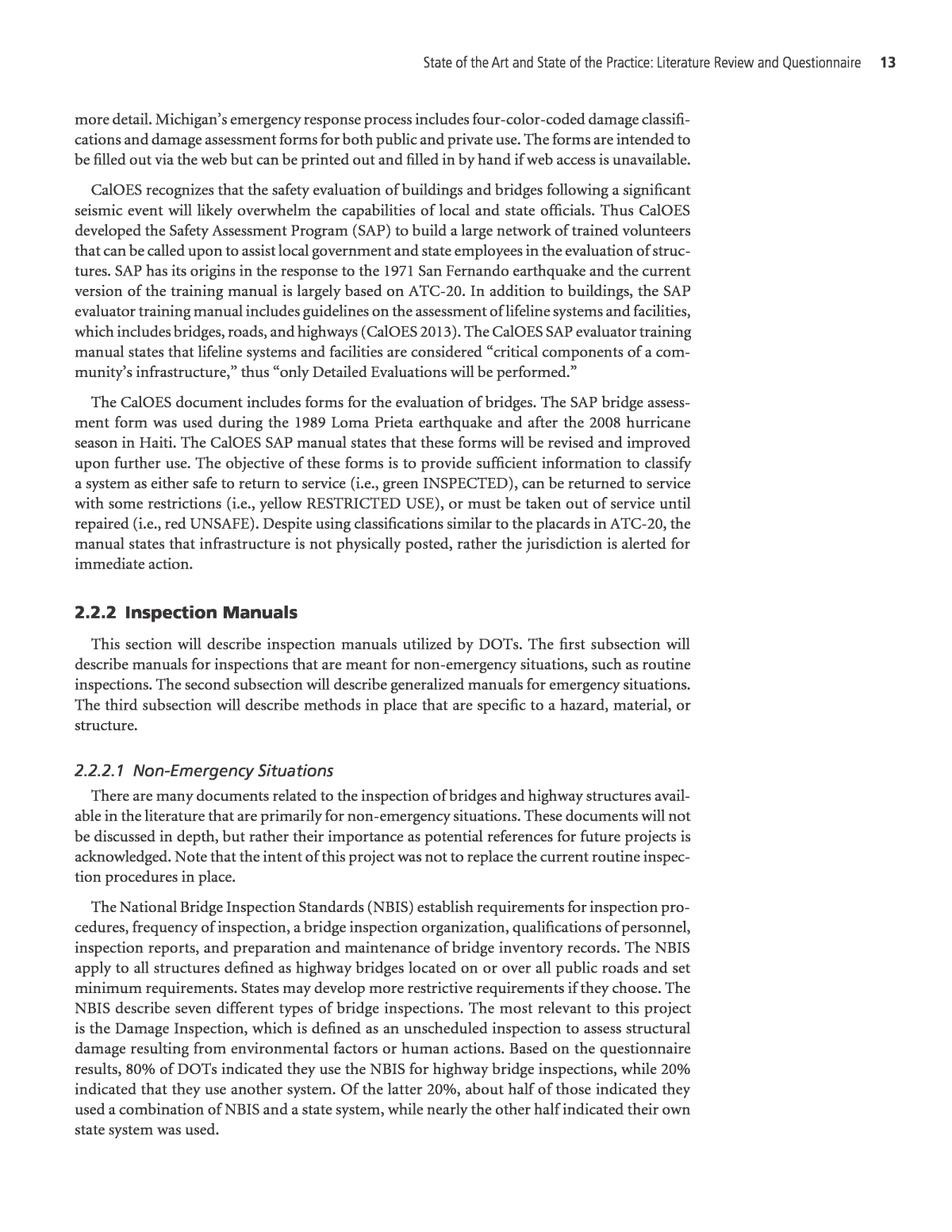
State of the Art and State of the Practice: Literature Review and Questionnaire 13 more detail. Michiganâs emergency response process includes four-color-coded damage classifi- cations and damage assessment forms for both public and private use. The forms are intended to be filled out via the web but can be printed out and filled in by hand if web access is unavailable. CalOES recognizes that the safety evaluation of buildings and bridges following a significant seismic event will likely overwhelm the capabilities of local and state officials. Thus CalOES developed the Safety Assessment Program (SAP) to build a large network of trained volunteers that can be called upon to assist local government and state employees in the evaluation of struc- tures. SAP has its origins in the response to the 1971 San Fernando earthquake and the current version of the training manual is largely based on ATC-20. In addition to buildings, the SAP evaluator training manual includes guidelines on the assessment of lifeline systems and facilities, which includes bridges, roads, and highways (CalOES 2013). The CalOES SAP evaluator training manual states that lifeline systems and facilities are considered âcritical components of a com- munityâs infrastructure,â thus âonly Detailed Evaluations will be performed.â The CalOES document includes forms for the evaluation of bridges. The SAP bridge assess- ment form was used during the 1989 Loma Prieta earthquake and after the 2008 hurricane season in Haiti. The CalOES SAP manual states that these forms will be revised and improved upon further use. The objective of these forms is to provide sufficient information to classify a system as either safe to return to service (i.e., green INSPECTED), can be returned to service with some restrictions (i.e., yellow RESTRICTED USE), or must be taken out of service until repaired (i.e., red UNSAFE). Despite using classifications similar to the placards in ATC-20, the manual states that infrastructure is not physically posted, rather the jurisdiction is alerted for immediate action. 2.2.2 Inspection Manuals This section will describe inspection manuals utilized by DOTs. The first subsection will describe manuals for inspections that are meant for non-emergency situations, such as routine inspections. The second subsection will describe generalized manuals for emergency situations. The third subsection will describe methods in place that are specific to a hazard, material, or structure. 2.2.2.1 Non-Emergency Situations There are many documents related to the inspection of bridges and highway structures avail- able in the literature that are primarily for non-emergency situations. These documents will not be discussed in depth, but rather their importance as potential references for future projects is acknowledged. Note that the intent of this project was not to replace the current routine inspec- tion procedures in place. The National Bridge Inspection Standards (NBIS) establish requirements for inspection pro- cedures, frequency of inspection, a bridge inspection organization, qualifications of personnel, inspection reports, and preparation and maintenance of bridge inventory records. The NBIS apply to all structures defined as highway bridges located on or over all public roads and set minimum requirements. States may develop more restrictive requirements if they choose. The NBIS describe seven different types of bridge inspections. The most relevant to this project is the Damage Inspection, which is defined as an unscheduled inspection to assess structural damage resulting from environmental factors or human actions. Based on the questionnaire results, 80% of DOTs indicated they use the NBIS for highway bridge inspections, while 20% indicated that they use another system. Of the latter 20%, about half of those indicated they used a combination of NBIS and a state system, while nearly the other half indicated their own state system was used.
14 Assessing, Coding, and Marking of Highway Structures in Emergency Situations: Research Overview The Bridge Inspectorâs Reference Manual is a comprehensive manual on programs, procedures, and techniques for inspecting and evaluating a variety of in-service highway bridges (Ryan et al. 2012). Several FHWA training courses have been developed based on the Bridge Inspectorâs Ref- erence Manual. The manual includes an extensive bibliography as well as a chapter on Advanced Inspection methods. The AASHTO Manual for Bridge Evaluation (MBE) was developed to assist bridge owners by establishing inspection procedures and evaluation practices that meet the NBIS (AASHTO 2011). The MBE includes a section on damage inspection and also describes bridge posting requirements. This manual includes many useful bridge evaluation references (Browne et al. 2010, Shanafelt and Horn 1984, Imbsen et al. 1987, Richardson and Davis 2001). Many states have their own inspection/evaluation manuals (Illinois DOT 2014; Mississippi DOT 2012a), but they often refer to the AASHTO MBE. In response to the questionnaire, many DOTs indicated that, for other highway structures (tunnels, walls, embankments, culverts, or overhead signs), they have written assessment procedures in place, including a manual or train- ing material (44%), or informal methods in place (22%), as shown in Figure 2-3(a). Two percent indicated that they had pictorial guides/references. 2.2.2.2 Emergency Situations In contrast to the availability of inspection materials for non-emergency situations, 40% of DOTs responding to the questionnaire indicated that there were no methods in place for emergency situ- ations, as shown in Figure 2-3(b). Only 22% of the respondents indicated that a manual or training material was in place, and 30% of the respondents indicated that informal methods were in place. The structure type is generally considered in these procedures (although to a larger extent in routine inspections); about 83% of respondents consider it for routine inspections compared No method in place 40% Informal methods in place 30% Manual or training material in place 22% Other 8% Q 8 - Does your agency have written assessment procedures for special inspections of highway structures specific to emergency situations? No method in place 6% Informal methods in place 22% Manual or training material in place 44% Other 26% Pictorial guides/ references 2% Q 7 - Does your agency have written assessment procedures for routine inspection of highway structures? Number of responses = 50 DOTs (a) (b) Figure 2-3. Questionnaire resultâassessment procedures in place for other structures in both (a) routine and (b) emergency situations.
State of the Art and State of the Practice: Literature Review and Questionnaire 15 to about 65% for emergency conditions (Table 2-5). Approximately 52% of respondents indi- cated that the emergency inspection procedures consider the different hazard types. However, in general, traffic levels are generally not considered in routine or emergency inspections, with only about 21% of the respondents indicating that they were considered in routine inspections and about 33% in emergency inspections. Respondents were asked about procedures in place for prioritization of inspections for responding to emergency situations. Field personnel reports (70%), predetermined lists or lifeline routes (58%), and preliminary geospatial analyses (42%) are all commonly used. Respondents also indicated that technologies such as ShakeCast [California DOT (Caltrans), WSDOT], aerial surveys (Tennessee DOT), and vulnerability assessments (Nevada DOT) are used for earthquake priority response. Florida and Utah DOTs indicated they use a combination of a predetermined list of critical structures and field personnel reports. Virginia DOT determines priority by a pre- determined list: major structures for earthquakes and areas most affected for flooding. Michigan DOT determines the priority for inspections as required by state emergency operations centers. Respondents generally indicated (90%) that the inspection procedures for emergency conditions consider the skill level/training of inspectors. An inspector has authority to close a bridge in 94% of respondentsâ jurisdictions. The other respondents indicated that an engineer had the authority. Respondents identified primary challenges (Table 2-6) for inspections by ranking a list (1 most important, 10 least important). The top three challenges identified are travel to the structure, access to the structure, and insufficient number of qualified inspectors. Routine Emergency Difference Yes No Yes No Q 7a/8a - Is the inspection different based on structure type? 82.6% 17.4% 64.5% 35.5% 18.1% Q 7b/8b - Is the inspection different based on hazard type? 37.0% 63.0% 51.6% 48.4% â14.7% Q 7c/8c - Is the inspection different based on traffic levels? 21.3% 78.7% 33.3% 66.7% â12.1% Number of responses = 46 DOTs for 7a/b/c, 31 DOTs for 8a/b/c. Table 2-5. Inspection routines based on structure, hazard, and traffic type. Q 11 â What are the most significant challenges your agency faces to properly assessing structures in emergency conditions? Rank Response Average Rank Max. Rank Min. Rank Median Rank Standard Deviation 1 Travel to the structure 2.81 1 9 2 2.07 2 Access to the structure 3.25 1 8 2 2.14 3 Insufficient number of qualified/trained inspectors 3.79 1 9 4 2.29 4 Communications 4.67 1 9 4 2.63 5 Limitations on technology for assessment 5.79 2 9 6 1.97 6 Coordination with other agencies 5.81 1 9 6 2.28 7 Lack of published procedures 5.94 1 10 6 2.45 8 Insufficient resources 6.35 1 10 7 2.56 9 Insufficient training 6.73 2 9 7 1.61 10 Other 9.85 4 10 10 0.87 Number of responses = 48 DOTs. Table 2-6. Ranked order of challenges to inspectors identified by respondents.
16 Assessing, Coding, and Marking of Highway Structures in Emergency Situations: Research Overview 2.2.2.3 Hazards/Material/Bridge Element Specific There are many documents that provide focused evaluation procedures for specific hazards and/or structure types. These include The Evaluation of Earthquake Damaged Concrete and Masonry Wall Buildings (ATC 1998a, ATC 1998b), âPost-earthquake Inspection Manual for RC Bridge Columnsâ (Veletzos et al. 2008), and A Guide to F-scale Damage Assessment [of Wood Frame Houses] (National Oceanic and Atmospheric Administration/National Weather Service 2003). Some documents are very comprehensive and focused on non-emergency situations but are relevant to this projectâs objectives such as the Underwater Inspection of Bridges (Collins et al. 1989) and the inspection guide in Effects of Fire Damage on the Structural Properties of Steel Bridge Elements (Brandt et al. 2011). PennDOT funded a series of projects that studied the corrosion and repair of pre-stressed girders, which included a study of various assessment techniques that included six different non-destructive testing (NDT) techniques (Harries et al. 2009, Jones et al. 2010, Naito and Warncke 2010, Naito et al. 2010). Some documents may be relevant for pre-event planning and offer risk-based algorithms to prioritize assessment and inspection (Heintz 2012, Laman and Guyer 2010). A few documents aim to standardize assessment practices (Geotechnical Extreme Events Reconnaissance 2011, Massarra 2012). Other documents describe the perfor- mance of specific structure types during past events (Youd and Beckman 1996). Optical technologies (e.g., lidar and satellite imagery) can provide regional damage assess- ment. Remotely sensed data are important to hazard investigation and damage assessment because these data can be remotely collected safely during disaster conditions (Olsen et al. 2013). Even in cases in which no previous data are available, optical remote sensing techniques provide high-resolution data, enabling more rapid damage assessment at a regional scale than many alternative methods. Collection of remotely sensed data prior to disasters can serve as baselines for future damage assessment, in addition to being useful for evaluating existing and future hazards. Finally, remotely sensed data, when processed, provide geographic information system (GIS) products for engineers, scientists, and planners to explore and study, without having to travel physically to the site. Caltrans developed an inspection and assessment procedure for earthquake damage to rein- forced concrete bridge elements (Veletzos et al. 2008). This approach is unique because it assesses the remaining displacement capacity. This is achieved by using five damage levels and classifying the expected response using three performance curves: ductile, strength degrading, and brittle (see Figure 2-4). The procedure includes a flowchart to identify the appropriate performance curve and a visual catalog of damage to determine the appropriate damage level. The damage Source: Veletzos et al. (2008). Figure 2-4. Performance curves of reinforced concrete bridge column.
State of the Art and State of the Practice: Literature Review and Questionnaire 17 on all columns of the bridge can be plotted on the appropriate damage curves to visualize the remaining capacity of the full structure (see Figure 2-4). 2.2.3 Collection, Reporting, and Visualizing Assessment Information There are numerous documents that describe methods for collecting, reporting, and visualizing assessment information. The majority use paper assessment forms (ATC 1989, CalOES 2013), while some utilize digital forms (McLane and Porter 2008, MSP 2013) which allow for rapid integration into an incident management system for regional visualizations (see Figures 2-5, 2-6, and 2-7). The inspection/assessment forms can be hazard specific and can vary by state and by the evaluation technique (i.e., Rapid or Detailed in ATC-20). 2.2.4 Critiques and Suggested Improvements to Current Assessment Methods Several recent studies attempt to improve upon current assessment methods considering recent disaster events. New Zealand researchers modeled their post-earthquake assessment pro- cedures after ATC-20 (Department of Building and Housing 2012). Thus, the recent earthquakes in New Zealand provide an opportunity to improve upon the existing ATC-20 documents. Several papers in the literature discuss lessons learned from the Canterbury, New Zealand, events and suggest improvements to current assessment procedures and the ATC-20 documents Source: MSP (2013). Figure 2-5. Michiganâs damage survey worksheet for public infrastructure (MSP 2013).
18 Assessing, Coding, and Marking of Highway Structures in Emergency Situations: Research Overview Source: MSP (2013). Figure 2-6. Screenshot of Michiganâs emergency management program showing the status view. Source: MSP (2013). Figure 2-7. Example of Michiganâs damage assessment map.
State of the Art and State of the Practice: Literature Review and Questionnaire 19 (Galloway et al. 2012, Lizundia et al. 2012, Wood et al. 2012). Although many of these are mainly applicable to building structures, they are important considerations for prioritizing inspection routes of highway structures or can be adapted to a highway structure assessment process. The following subsections summarize key findings of the papers. 2.2.4.1 Assessment Process The following recommendations were made for the New Zealand assessment process: ⢠The objective of a Level One Rapid Assessment (roughly equivalent to the Rapid Evalu- ation in ATC-20) should be to determine whether a building is immediately considered dangerous or needs a Level Two Rapid Assessment (roughly equivalent to the Detailed Evaluation in ATC-20). ⢠A new Interim Use Evaluation should be defined, which would be carried out by the ownerâs engineer to establish suitability for re-occupation. It is recommended that this would be essen- tially the same as a Level Two Rapid Assessment, unless the primary vertical or lateral load resist- ing systems cannot be identified. In this case, further research would be required to identify the primary structural systems in order to establish the extent and significance of damage observed. Guidance on this process has been developed and published for the Greater Christchurch region by the Department of Building and Housing (Department of Building and Housing 2012). ⢠Triage should be used to gain an overview of the damage, identify collapse-vulnerable build- ings, ensure people are not trapped in any of the buildings, and inform urban search and rescue teams. ⢠Indicator structures should be identified. Following a large earthquake, many buildings become damaged and are susceptible to additional damage from aftershocks. Some aftershocks may be strong enough to damage previously undamaged buildings. An important decision officials must make is when to require the re-inspection of previously inspected buildings. If an indicator build- ing showed new damage after an aftershock, similar buildings nearby that likely experienced the shaking could then be re-examined for safety. This can also be combined with strong motion instrumentation reports to assist decision makers. 2.2.4.2 Technology Utilization The following recommendations were made regarding New Zealand utilization of technology to support assessing, coding, and marking: ⢠Development of a Structure Database: The primary objective of the approach is to gather data on the expected earthquake performance of existing buildings. Summary information for each building could then be provided to assessment teams to inform the rapid building safety evalua- tions being carried out. In particular, identification of the expected vulnerabilities is considered to be of great benefit when carrying out a rapid visual assessment of damage as these vulnerabilities may not be identifiable without reference to building plans and details. ⢠Targeted Safety and Evaluation Operations: These are specialized task forces or operations to address sections of the city or issues of the community, rather than the block-by-block method that has often been used in other cities. ⢠Use of Internet and Social Media for Information Updates: The Christchurch City Coun- cil made relatively extensive use of the Internet and social media to provide near-real-time updates to the public on the response and recovery process of the region. This included maps showing the specific zones within the cordoned areas and planned dates for these area cordons to be lifted, and maps that showed areas of higher risk from buildings that could potentially collapse in a strong aftershock. The use of Internet and social media (crowdsourcing) in disaster response as recommended by New Zealand researchers is one example of how, for present and future disaster response,
20 Assessing, Coding, and Marking of Highway Structures in Emergency Situations: Research Overview modern information technologies should be incorporated to assist in the assessing, coding, and marking of damaged structures. Several of these approaches that utilize IT are discussed in the following paragraphs. ATC-67 developed a smartphone app [ROVER (Rapid Observation of Vulnerability and Estimation of Risk)] that uses Federal Emergency Management Agency (FEMA)-154 proce- dures for rapid visual screening of buildings for potential seismic hazards and ATC-20 for post-earthquake tagging of buildings (McLane and Porter 2008). This app is integrated with USGS real-time earthquake monitoring software (ShakeCast) and FEMA multi-hazard dam- age and loss estimation software (Hazus-MH) (FEMA 2006). ROVER has been successfully tested by the Los Angeles Unified School District, the Utah Seismic Safety Commission, and others. Peña-Mora et al. (2008) reviewed the role of civil engineers in disaster response with a focus on existing building assessment and marking systems and highlighted various limitations of existing approaches (Table 2-7). They discussed a mobile IT-based collaborative framework to facilitate a coordinated disaster response and recovery operation. This framework enables engineers to assess building damage better and to make this information available to personnel more quickly and easily within the disaster area and thereby improve disaster response. The deployed architecture is composed of various components including various sensing, scanning, and tagging devices for structural assessment, a field engineerâs mobility and information sup- port platform, and GIS-based resource optimization (see Figure 2-8). As mobile- and cloud- computing technologies continue to advance, the command post concept as shown in Figure 2-8 may become outdated; sophisticated data processing and analytics can be realized through collaborative distributed mobile-computing systems rather than a centralized command post (Chen et al. 2013). 2.3 Coding and Marking Procedures During emergency events, it is important for first responders, safety personnel, inspectors, and the traveling public to have and be able to rely on a common method to code and mark highway structures. For this report, the following definitions are intended: ⢠CodingâThe process of using a shortened notation or series of code to indicate the status of a structure, its components and elements, and other parameters associated with it. Identified Requirement Brief Description of Obstacle Communication and collaboration support Difficulties in knowledge sharing. Inability to access information and the lack of standardization, collaboration, coordination, and communication. Provision of real-time data to field personnel First respondersâ needs for information access and sharing are not well supported and are often disconnected from both the information systems and databases central to effective homeland security. Visual data capture Although different types of disasters call for different types of response, most situations can be improved by having visual images and other remotely sensed data available. On-site building assessment marking Building marks are not visible because of re-marking/smoke/debris on site and are updated at Incident Command Center after 8 to 12 hours through its established work cycles. Multiple connectivity options Existing terrestrial links can easily saturate and collapse at the time of disasters. For instance, after the 9/11 attacks, cellular phones did not work because of the destruction of antennae systems. Source: Peña-Mora et al. (2008). Table 2-7. Key obstacles in effective disaster response.
State of the Art and State of the Practice: Literature Review and Questionnaire 21 ⢠MarkingâThe process of applying an identifiable mark to the structure to inform others of its condition. This can be done physically or digitally. The physical marking of a structure is sometimes referred to as âposting.â Today, a consistent, well-established methodology for accomplishing these critical tasks for highway structures in emergency situations does not exist. A review of the literature reveals, in general, very little published information on coding and marking systems at either the federal, state, or local level for highway structures both here in the United States or internationally. One of the practical reasons for this is the challenge inherent in the need for any coding and marking system intended for the general public to be visible and of value to someone driving at highway speeds. 2.3.1 Coding and Marking of Highway Structures Notably, the FHWA provides courses in bridge inspection under non-emergency condi- tions. Part of that training involves the use of a detailed coding system (FHWA 1995) that in effect provides the data elements for the National Bridge Inventory (NBI) database. Since all of the trained bridge inspectors in the United States are required to use this system, there may be an opportunity to use part of it, particularly for the more detailed inspections after an emergency event. Pennsylvania (Laning and Bankert 2008), Ohio (Ohio DOT 2012), and New York (NYSDOT 2006) have published similar manuals for their inspector training and reference. New York uses an electronic reporting system to populate its bridge inventory database. There are more than 20 codes including bridge identification, structural details, safety and utility, Source: Peña-Mora et al. (2008). Figure 2-8. The deployed system architecture.
22 Assessing, Coding, and Marking of Highway Structures in Emergency Situations: Research Overview inspection responsibility, and load rating, for example. Within each major category, the detail codes are defined. For example, under safety and utility there are approximately 10 codes to characterize the type of guard rail terminus. WSDOT has a reference document for dealing with seismic events entitled An Emergency Response Plan for Bridge Management (Reed and Wang 1993). Inspection forms were developed to support a three-stage inspection process and office procedures were developed for emergency response. A computer database that makes use of the WSDOTâs seismic database was used to develop the plan. Workshops involving the WSDOT, the Division of Emergency Management, and the Department of Community Development were recommended. Research (Ranf et al. 2007) was also conducted at the University of Washington to improve the prioritization of bridge inspections by including not only the distance from the epicenter, but also the age of the bridge. The Indiana DOT in its Handbook for the Post-earthquake Safety Evaluation of Bridges and Roads (Ramirez et al. 2000) describes the use of ribbons by inspectors to communicate the con- dition of the bridge post inspection. These appear to be for internal use only. The system speci- fies the use of a red ribbon to indicate the bridge should be closed; yellow if it requires a more detailed inspection; and green if it is safe to use. The ribbons with the initials of the inspector are to be attached to the bridge sign post. If the bridge is unsafe to use, a request for barricades should be made to the proper group. NCHRP Report 525: Surface Transportation Security, Volume 16: A Guide to Emergency Response Planning at State Transportation Agencies (Wallace et al. 2010) is designed to help executive man- agement and emergency response planners at state transportation agencies as they and their local and regional counterparts assess their respective emergency response plans and identify areas needing improvement so as to be in synchronization with the all-hazards context of the National Incident Management System (NIMS). The report does not specifically address the issues of cod- ing and marking, but it is clear that any system will have to be compatible with the emergency transportation operations for each state. To reduce the impact from traffic incidents, the FHWA has developed a traffic incident man- agement process and training program for first responders (FHWA 2012). This training pro- gram could be a source of valuable information for handling emergency events. A team of U.S. tunnel professionals performed a scan of best practices in Europe in 2005 and presented key findings in a report entitled, Underground Transportation Systems in Europe: Safety, Operations, and Emergency Response (Ernst et al. 2006). The U.S. tunnel engineering community relies on National Fire Protection Association (NFPA) Standards 130 and 502. The AASHTO Subcommittee on Bridges and Structures has formed T-20, the Technical Commit- tee on Tunnels to take the lead on tunnel safety during emergency situations. They found that members of the general public are in effect their own first responders when they find themselves in an emergency. To aid the general public with a safe response, software is being used in Europe in conjunction with video to automate emergency procedures. A one-step procedure is recom- mended to reduce the chance for human error during an emergency. Only 30% of respondents to the questionnaire indicated that they have a manual or training material on guidelines for coding and marking of highway structures during emergency situa- tions, as shown in Figure 2-9. While 24% indicated that informal procedures are in place within their DOT, 34% indicated that no method is in place and 12% indicated that they were not aware of any within their agency. With respect to marking of structures during emergency inspections, 32% of respondents always mark, 10% often mark, 16% sometimes mark, 12% rarely mark, and 22% never mark; 8% were not sure (Figure 2-10). Those that do mark the structure indicated that the marking is typically done in a report (58%) or entered into a database (36%), rather than physically on the
State of the Art and State of the Practice: Literature Review and Questionnaire 23 Number of responses = 50 DOTs Not aware 12% No method in place 34% Informal methods in place 24% Manual or training material in place 30% Q 13 - Does your agency have guidelines for coding and marking of highway structures during an emergency situation? Figure 2-9. Availability of guidelines for coding and marking during emergency situations. Always 32% Often 10% Sometimes 16% Rarely 12% Never 22% Not sure 8% Q 14 - Does your agency mark structures once an emergency or special inspection is completed? Number of responses = 50 DOTs Figure 2-10. Frequency of marking following emergency or special inspections. structure. Other methods of marking included spray paint (18%), posting via the web or other digital media (18%), and yellow caution tape (85%). Thirty-four percent of respondents use some other technique for coding and marking of structures, including the following: ⢠Colored lumber crayon in an obvious location ⢠Colored tape or ribbon (red, yellow, and green) ⢠Structures tagging sticker
24 Assessing, Coding, and Marking of Highway Structures in Emergency Situations: Research Overview ⢠Mississippi DOTâs procedure from Annex E of its Comprehensive Emergency Transportation Response Plan (page E-22) based on earthquakes ⢠Barricades, detour signs, and traffic control devices for bridges required to be closed 2.3.2 Relevant Coding and Marking Practices for Buildings Most of the remaining literature comes from other emergency management scenarios such as the coding and marking of buildings post-earthquake disasters or, in the case of fire events, from NFPA standards. The latter includes NFPA 130, Standard for Fixed Guideway Transit and Pas- senger Rail Systems, and NFPA 502, Standard for Road Tunnels, Bridges and Other Limited Access Highways (NFPA 2014a, 2014b). âBuilding Assessment During Disaster Response and Recoveryâ (Peña-Mora et al. 2008) reviews the role of civil engineers in disaster response with a focus on building assessment and marking. It presents a mobile IT-based collaborative framework to facilitate a coordinated disas- ter response and recovery operation that includes the use of radio-frequency identification tags and GIS database support. Peña-Mora et al. developed a scoring system to determine which structures will receive operational priority based on the highest probability of success in find- ing and rescuing live victims. Buildings with the highest scores receive attention first. A similar approach could be applied to highway structures based on their importance to the transportation network and their likely resilience to damage. The paper discusses the importance of having a standard building assessment and marking system to communicate the buildingâs stability and suitability for use to all concerned person- nel. The paper identifies three systems: the National Urban Search and Rescue Response System, which utilizes fluorescent orange spray paint to apply the markings; the International Search and Rescue Response System; and the ATC system, which is for recovery only. The ATC-20 protocol became the de facto standard after being used in response to the attacks of 9/11. The ATC system has three levelsâRapid, Detailed, and Engineeringâfor the assessments. Green, yellow, and red placards indicate INSPECTED (no restrictions on use), LIMITED USE, and UNSAFE, respec- tively. Peña-Mora et al. note that, unfortunately, different systems can be used by agencies that are part of the same disaster response, creating significant problems for the teams. CalOES recently published Version 12 of the Safety Assessment Program Evaluator Student Manual (CalOES 2013). This document provides a detailed overview of the Safety Assessment Program as part of the training for SAP evaluators. This program is based on the use of ATC-20-2. It discusses earthquakes, windstorms, floods, fires, and explosions. The program provides for the use of placards to communicate the condition of structures, excluding highways and bridges. The program includes buildings as well as what it refers to as lifeline systems and facilities, which includes airports, bridges, roads and highways, and more. Duly authorized representatives of a jurisdiction are the only persons who can officially post the placards. Formally adopted placards will have the jurisdictional seal on them and will have a reference to the adoption ordinance. In California there is liability protection for the inspec- tors and a local jurisdiction would not be liable for workmanâs compensation if they deputize an inspector. The current placard system in use in California is ATC-20-2 (ATC 1995). Green, yellow, and red indicate INSPECTED, RESTRICTED, and UNSAFE, respectively. Standard forms are provided to support each level of inspection and marking. California also uses ATC-20-2 for lifeline structures such as bridges and roads/highways. The forms use a ranking of 0 to 6 to code the observed damage. Placards are not used to mark bridges or roads/highways as they are too small for motorists to see. Barricades are the recommended method for restricting access to unsafe structures.
State of the Art and State of the Practice: Literature Review and Questionnaire 25 2.3.3 Critiques and Suggested Improvements to Current Coding and Marking Methods As described earlier, several recent studies attempt to improve upon current coding and mark- ing methods considering recent disaster events. Much of the previously cited literature provides recommendations for coding and marking (termed âplacard placementâ) from lessons learned from the Canterbury, New Zealand, events and suggests improvements to current assessment procedures and the ATC-20 documents (Galloway et al. 2012, Lizundia et al. 2012, Wood et al. 2012). Although many of these are mainly applicable to building structures, they are important considerations for prioritizing inspection routes of highway structures or can be adapted to a highway structure assessment process. The following recommendations were made for placard placement: ⢠Only suitably experienced structural engineers should be permitted to issue placards (although they may be teamed up with building control officials, etc.). ⢠There should be a roaming auditor to ensure consistency between assessments carried out by different teams and to identify teams that may not display the required engineering judgment. ⢠Should an engineer be unable to determine the lateral load resisting system, the building should receive a yellow placard, regardless of the absence of apparent structural damage. ⢠A minor change to the placard colors is proposed to ensure the public reads the detail of the placards. Using red, yellow, and white would remove the visual correlation between green and go/safe. ⢠The placards should include a clear distinction as to whether they are based on a Level One or Two assessment. ⢠The only possible outcome of a Level One Rapid Assessment should be either a red (UNSAFE) placard or a new (perhaps white) placard noting that the building has been visited, but that it requires a further Level Two assessment. Yellow or green placards should not be outcomes of a Level One Rapid Assessment. ⢠Usability categories should be introduced. Usability categories were used for some assessments in Christchurch as part of the Level Two Rapid Assessment to provide an additional level of information to building occupants, managers, and owners. For the INSPECTED (green) post- ing, the usability categories were G1 (occupiable, no immediate further action required) and G2 (occupiable, repairs required). For the RESTRICTED USE (yellow) posting, the categories were Y1 (short-term entry) and Y2 (no entry to parts until repaired or demolished). For the UNSAFE (red) posting, the categories were R1 (significant damage, repairs or strengthening possible); R2 (severe damage, demolition likely), and R3 (at risk from adjacent premises or from ground failure). 2.3.4 Coding and Marking Conclusions There is very little published information on the topics of coding and marking of highway structures during emergency events. There is a well-established system of codes for routine bridge inspections, but those were designed for a different purpose and their required level of detail is not suitable for the majority of emergency responders. There may be an opportunity to make use of some of the procedures developed by the NFPA and/or ATC although they were not intended for the specific purpose of this project. The use of a three-level system to communicate with the general public that the condition is safe, restricted, or unsafe using green, yellow, and red, respectively, would seem to be the most valuable methodology to consider in the development of the proposed guidelines. However, if there is a need to communicate with the public at highway speed, this approach may not be practical.
26 Assessing, Coding, and Marking of Highway Structures in Emergency Situations: Research Overview For emergency responders, a more technical methodology could be implemented that makes use of the well-established bridge inspection coding system, at least for the more detailed inspec- tions. If the communication system could be relied upon to support access to the Internet, then a number of new strategies would become available for communicating with the general public and among the emergency responders. 2.4 Emergency Response and Communication 2.4.1 Emergency Management Overview Emergency management involves preparing for, responding to, and recovering from an emer- gency or disaster. It is a continuous process by which all levels of government manage hazards in an effort to lessen or avoid the impact of disasters resulting from hazards (FHWA 2014). In general, a government agency can discharge their emergency management responsibilities by taking five interrelated actions: prevention, protection, mitigation, response, and recovery (DHS 2011, FEMA 2010). For the purposes of this project, this section will focus primarily on response and aspects that are important for communicating results of structural inspections. 2.4.1.1 National Incident Management System The NIMS was produced to standardize the management of emergencies in the United States as well as to implement a system to allow all agencies, departments, and jurisdictions to work together to manage emergencies when necessary (DHS 2008). The NIMS is made up of the following five components: (1) preparedness, (2) communication and information manage- ment, (3) resource management, (4) command and management, and (5) ongoing management and maintenance. Figure 2-11 defines the emergency response process based on the NIMS and National Response Framework (NRF). Source: Based on McCormick Taylor, Inc. (2006). Figure 2-11. National Response Framework and National Incident Management System.
State of the Art and State of the Practice: Literature Review and Questionnaire 27 2.4.1.2 National Response Framework The NRF is a guide for how our nation conducts national all-hazards incident response that builds upon the NIMS (DHS 2013). It describes structures for achieving nationwide response policy and operational coordination for all types of domestic incidents. Federal assistance avail- able to augment state and local response efforts is formulated under NRFâs 15 Emergency Sup- port Functions (ESFs). The most pertinent to this project is ESF #1, Transportation. ESF #1 provides support by assisting local, state, tribal, territorial, insular area, and federal government entities, voluntary organizations, non-governmental organizations, and the private sector in the management of transportation systems and infrastructure during incidents (DHS 2013). The primary and coordinating agency of ESF #1 is the transportation agency. ESF #1 includes the following functions: ⢠Monitoring and reporting status of and damage to the transportation system and infrastruc- ture as a result of the incident ⢠Identifying temporary alternative transportation solutions that can be implemented when systems or infrastructure are damaged, unavailable, or overwhelmed ⢠Coordinating the restoration and recovery of the transportation systems and infrastructure 2.4.1.3 Emergency Plans EOPs define the scope of preparedness and emergency management activities necessary. DOTs will either have a stand-alone EOP or the DOT plan will be an annex, appendix, or supple- ment to the stateâs EOP. All levels of governmentâlocal, tribal, state, and federalâincluding their division officesâprepare formal EOPs to establish authorities, responsibilities, and proce- dures on how the organization will operate in response to a disaster or emergency. The federal government has provided many tools to aid state and local agencies in developing EOPs, most notably, the Comprehensive Preparedness Guide (CPG) 101. The CPG 101 provides guidelines that help planners at all levels of government in their efforts to develop and maintain viable all-hazards, all-threats EOPs (FEMA 2010). FEMA recommends that teams responsible for developing EOPs use CPG 101 to guide their efforts. Along with EOPs, several state and local agencies will also develop emergency response plans (ERPs) or emergency preparedness plans (EPPs). Based on the questionnaire, 80% of state trans- portation agencies have an ERP or an EPP on file that is either comprehensive for most hazards (60% of DOTs) or different for each hazard (20% of DOTs), as shown in Figure 2-12(a). To determine the relative maturity of these plans, respondents were asked how long these plans have been in place [Figure 2-12(b)]. Responses were more than 10 years (40%), within 10 years (20%), within the last 5 years (23%), and within the last year (2%). Of the respondents, 15% were not sure of the relative age of these procedures. These responses indicate that many DOTs are taking steps to prepare for potential emergency events and are developing plans. However, given the frequency of occurrence for many events, it is likely that many of these procedures have not been fully tested during actual events. In addition, the relative age of these plans implies that the latest advances in potential assessing, coding, and marking techniques are not incorporated. Hence, future refinements are very likely to be necessary. Thirty-six respondents (77%) indicated that they were part of the EPP or ERP team. These respondents indicated that there is a strong level of interaction with federal agencies (100%). Of those EPP or ERP respondents, 97% also indicated that they assess structures as part of the EPP/ ERP. However, at the local level, 59% of the respondents indicated that the local government does not follow their EPP/ERP. There appears to be minimal coordination with data sharing, which consists predominately of inspection data. Other types indicated by the respondents were emergency needs and information and scour monitoring plan of action.
28 Assessing, Coding, and Marking of Highway Structures in Emergency Situations: Research Overview 2.4.2 Emergency Preparedness and Response To identify the relative frequency of hazards facing state DOTs, questionnaire respondents were asked to identify hazards they have faced in the past (Figure 2-13). Flooding (100%), col- lision (100%), scour (92%), and high winds (90%) were identified as the hazards experienced by most state DOTs. The next most frequently experienced hazards are fire (80%), tornados (66%), and earthquakes (50%). It is interesting to note that the majority of available literature Number of respondents = (a) 50 DOTs, (b) 40 DOTs Yes, a comprehensive plan in place for most potential hazards 60% Yes, a different plan for each type of hazard 20% No, nothing in place 12% Unsure 8% Q 5 - Does your agency have an emergency preparedness plan (EPP) or emergency response plan (ERP) that deals with potential hazards? Not sure 15% Within thelast year 2% Within the last 5 years 23% Within the last 10 years 20% More than 10 years 40% Q 5a - How long has at least one plan been in place? (a) (b) Figure 2-12. Emergency preparedness plans or emergency response plans (a) in place with state DOTs and (b) general length of time that such policies have been in place. Respondents = 50 DOTs 50% 6% 42% 90% 46% 100% 92% 66% 80% 100% 6% 6% 0% 10% 20% 30% 40% 50% 60% 70% 80% 90% 100% D O Ts Q 4 - Hazards Experienced Ea rth qu ake Ts un am i Hu rric ane Hi gh W ind s Sto rm Su rge Flo od ing Sc ou r To rna do Fir e Co llis ion -R ela ted Tr aff ic A cci den t Te chn olo gic al Ex plo sio n Ot her Figure 2-13. Hazards experienced by state DOTs.
State of the Art and State of the Practice: Literature Review and Questionnaire 29 and established procedures are related to earthquakes rather than these more common hazards. This is likely because of the widespread nature and higher level of damage expected during an earthquake. Emergency response begins at the local level and expands to the state and federal level during large disasters where the local government cannot handle the emergency response. The Incident Command System (ICS) is the foundation of emergency management throughout the United States since the inception of the NRF and NIMS (CalOES 2013). Figure 2-14 describes the emergency/disaster declaration process of Michigan. Under ICS, the lowest level of government closest to the disaster is responsible for the management of the emergency response within its jurisdiction. Higher levels of government will then assist in supplying personnel and equipment to aid in the response. Figure 2-15 highlights the relationship between complexity of emergen- cies and response. Effective emergency response requires collaboration between multi-jurisdictional agencies. Col- laboration is a necessary foundation for dealing with both natural and technological hazards and disasters (Waugh and Streib 2006). Among the possible modes of cooperation, multi-stakeholder cooperation is favored for the management of complex emergency management situations (Smith 2014). Incident communications are facilitated through the development and use of common communications plans and interoperable communications equipment, standards, and Source: MSP (2013). Figure 2-14. Michiganâs emergency/disaster declaration process.
30 Assessing, Coding, and Marking of Highway Structures in Emergency Situations: Research Overview processes. The concepts and principles for effective communication are defined by NIMS as having a common operating picture; interoperability; reliability, scalability, and portability; and resiliency and redundancy. These concepts and principles reinforce the use of a flexible com- munications and information system in which emergency response personnel can maintain a constant flow of information during an incident (DHS 2008). From the questionnaire, respondents were asked what agencies they coordinate with dur- ing emergency situations (Figure 2-16). State emergency agencies (84%), FEMA (82%), and Source: Wallace et al. (2010). Figure 2-15. The complexity of emergencies and response. Number of respondents = 49 DOTs. 36% 82% 44% 84% 26% 54% 24% 0% 10% 20% 30% 40% 50% 60% 70% 80% 90% 100% OEM FEMA DHS State Emergency Agency Red Cross National Guard Other D O Ts th at R es po nd ed Q 26 - Which agencies does your agency coordinate with during an emergency situation? Figure 2-16. Coordination with other emergency agencies.
State of the Art and State of the Practice: Literature Review and Questionnaire 31 the National Guard (54%) were the primary agencies identified. Many respondents indicated a high level of coordination with other outside agencies (Figure 2-17). Other agencies identified by respondents include the FHWA; U.S. DOT; state police/highway patrol; state health agencies; regional bridge managers; other state DOTs; U.S. Coast Guard; and various other state, county, or local agencies. Respondents indicated that coordination could be most improved by single points of contact, secure websites, or annual in-person meetings (Table 2-8). While some DOTs (33%) have integrated their asset management and pavement informa- tion with emergency response information, most have not done this. However, the majority (60%) indicated that they coordinate with those divisions during emergency events to obtain the necessary data. 2.4.3 Transportation Infrastructure Emergency Response Rapid assessment of transportation structures is critical following a disaster since they may exist along evacuation routes and can impede evacuation or the movement of emergency person- nel and supplies into the disaster zone. States that generally are not affected by natural disasters may have very little preparation for natural disasters and are likely to concentrate on accidental vehicle impacts. Although a vehicle impact creates a similar need for assessment, it is more likely Number of respondents = 45 DOTs. 12% 2% 0% 6% 2% 16% 6% 12% 22% 10% 12% 0% 5% 10% 15% 20% 25% 0 1 2 3 4 5 6 7 8 9 10 D O Ts th at R es po nd ed Coordination (0 = Not sure, 1 = No coordinationâ¦. 10 = Complete integration) Q 27 - What is the current level of coordination between your agency and outside agencies? Figure 2-17. Level of coordination with other emergency agencies. Q 28 â What would improve emergency coordination for your agency? Rank Response Average Rank Max. Rank Min. Rank Median Rank Standard Deviation 1 Identify a single point of contact within the DOT 2.75 1 6 2 1.74 2 Create a secure website to manage coordination 2.77 1 5 3 1.31 3 Have an annual face-to-face meeting 2.84 1 5 3 1.16 4 Arrange a regularly scheduled conference call 3.34 1 5 3 1.29 5 Have more mock training events 3.64 1 6 4 1.53 6 Other 5.66 1 6 6 1.20 Number of respondents = 44 DOTs. Table 2-8. Rankings of potential improvements to coordination.
32 Assessing, Coding, and Marking of Highway Structures in Emergency Situations: Research Overview to be localized, usually affecting only one structure. Under ESF #1, state DOTs are the primary and coordinating agency for transportation structure assessment. 2.4.3.1 State DOT Response Within an all-hazards framework, state DOTs have certain transportation-oriented responsi- bilities. During the response of an emergency, DOTs will activate appropriate plans, procedures, and protocols and mobilize available personnel, equipment, facilities, devices, and information to support emergency response (Wallace et al. 2010). It is also in this stage that state DOTs will begin performing damage assessment responsibilities for affected transportation system ele- ments. This process involves clear lines of communication between numerous teams and agen- cies as shown in Figure 2-18. Decisions will be made regarding closures, contraflow operations, Source: Reed and Wang (1993). Figure 2-18. WSDOT emergency response communication for bridge management.
State of the Art and State of the Practice: Literature Review and Questionnaire 33 restrictions, and priority repairs. Damage assessments will continue during the recovery phase (Wallace et al. 2010). 2.4.3.2 Training Volunteer Response Very-large-extent emergencies are likely to overwhelm the capabilities of local and state offi- cials. In these situations, there is a need for properly trained volunteers to assist with the assess- ment of structures. Several agencies and associations across the United States have been working to fill this need. These include the CalOES SAP (CalOES 2013) and the Structural Engineering Emergency Response Program (National Council of Structural Engineers Associations 2011). These programs coordinate training and organize volunteers to be called up by local or state emergency management agencies to assist in the safety evaluation of structures during an emer- gency response when necessary. These volunteer groups currently exist or are being developed in some states (Rhode Island, Massachusetts, California to name a few) but likely do not exist in all states. 2.4.4 Concluding Remarks Homeland Security Presidential Directives helped shape the foundation of emergency response and communication by establishing national frameworks such as NIMS, NRF, and ICS. These frameworks serve key roles in the development of state EOPs, ERPs, and EPPs. Ulti- mately, all incident response begins at the local level and progresses toward the state and federal level depending on the complexity of emergency, as shown in Figure 2-15. ESF #1 specifies state DOTs as the primary and coordinating agency for transportation structure assessment. Many states have developed emergency response procedures specific to the assessment of highway structures following an emergency; however, these procedures are likely to differ between states. It is crucial following an emergency for state DOTs to properly and quickly assess, code, and mark the integrity of the transportation system and this process begins with a well-established EOP, ERP, and EPP. CPG 101 is currently the most useful guide in helping planners develop and maintain viable all-hazards and all-threats EOPs. Some good examples of plans set in place by DOTs are Ohioâs EOP (Ohio DOT 2013), Mississippiâs ERP (Mississippi DOT 2012b), and Wyomingâs Multi-Hazard Mitigation Plan (Wyoming DOT 2011). 2.5 Training In the questionnaire, respondents were asked about the level of training available for various types of emergency events (Figure 2-19). Training is most common for scour, flooding, collision, and earthquakes. However, in general, minimal training is completed for other types of hazards, where training is typically not performed frequently, if at all. When asked how effective various training material was, periodic refresher courses and flip- books and pocket manuals were given the highest overall rankings (Table 2-9). 2.6 Technology/Data Similar results are observed in the usage of current technology in routine conditions com- pared to the priority of technology usage in emergency situations (Figure 2-20). The two primary findings are (1) the order in which digital technologies are currently most often used is largely consistent with the order of priority given to digital technologies during emergency response and (2) smartphones and tablets are given higher priority in emergency events. This implies that the community is keen to use smart mobile technologies for rapid emergency response.
34 Assessing, Coding, and Marking of Highway Structures in Emergency Situations: Research Overview Number of respondents = 44 DOTs. 0 1 2 3 4 5 Earthquake Tsunami Hurricane High Winds Storm Surge Flooding Scour Tornado Fire Collision Technological Explosion Volcanoes Terrorist attacks Snow/ice/avalanche Other Average Frequency (0 = None, 2 = Once every 5 years, 4 = Once every 2 years) Q 16 - What level of training does your agency provide for assessing, coding, and/or marking of structures during the following emergency events? Figure 2-19. Level of training by state DOTs for hazards. The bars show the standard deviation of the responses for each category. Q 17 â Please order the following list based on your agencyâs needs to train individuals in the proper emergency response and assessment procedures. Rank Response Average Rank Max. Rank Min. Rank Median Rank Standard Deviation 1 Periodic refresher course 1.98 1 4 2 0.99 2 Flip-books and pocket manuals 2.17 1 4 2 0.99 3 Simulations 2.94 1 5 3 1.15 4 E-learning training courses 3.02 1 4 3 1.07 5 Other 4.89 1 5 5 0.60 Number of respondents = 47 DOTs. Table 2-9. Rankings of training material effectiveness. 2.6.1 Data Management In the questionnaire, respondents were asked how structural assessment data are currently managed within their organization. Eighty percent of respondents indicated data are centrally managed, 14% indicated regionally managed, and 6% indicated individually by department. Most respondents also indicated that they have well-developed and functioning systems in place for asset management and inventory (Figure 2-21). Ninety-six percent of respondents indicated that information regarding structure type and traffic levels was available. Sixty-seven percent of respondents indicated data are tied to geospatial coordinates and 23% indicated that they are tied to another system such as a linear referencing system [Figure 2-22(a)]. Ninety-two percent of respondents indicated that these data are stored in digital databases [Figure 2-22(b)]. Analyzed together, these responses indicate that DOTs are comfortable with digital, geospatial database management and sharing for structural assessment data. 2.6.2 Adoption of New Technologies Respondents were asked about their agencyâs experiences with adopting new technologies (Figure 2-23). Thirty percent indicated that their agency tries to stay in the forefront; 38%
State of the Art and State of the Practice: Literature Review and Questionnaire 35 Number of respondents = 48 DOTs. 0 1 2 3 4 5 6 7 8 9 10 Hand-held GPS Digital photo and video cameras Tablets/smartphones Laser range finders Lidar/3D laser scanning Advanced technologies such as GPR, seismic surveys, thermal imaging UAVS Low-tech assessment aids Other Q 18 - How often does your organization use the following digital technologies for highway structure assessment under ordinary circumstances? Q 19 - What priority would your agency place on the following digital technologies in recommended emergency response procedures? Not sure Rarely Sometimes Often Routinely Low Medium High Figure 2-20. Current technology usage in routine conditions and anticipated technology usage in emergency response. Number of respondents = 49 DOTs. 4% 0% 12% 6% 0% 10% 10% 14% 16% 14% 14% 0% 5% 10% 15% 20% 0 1 2 3 4 5 6 7 8 9 10 D O Ts th at R es po nd ed Type of System (0 = Not sure, 1 = No system in place, 10 = Detailed system that covers most needs) Q 21 - What type of system is in place for your agency's highway structures inventory and/or asset management to assist in managing critical structures? Figure 2-21. Inventory and assessment management systems in place for managing critical structures.
36 Assessing, Coding, and Marking of Highway Structures in Emergency Situations: Research Overview Number of respondents = (a) 49 DOTs, (b) 50 DOTs. LRS = linear referencing system Yes, data are tied to geospatial coordinates 67% Data are tied to another system such as LRS 23% No spatial referencing is used 10% Q 24 - Is your agencyâs structural assessment data linked to geospatial/spatial coordinates? Yes 92% No 8% Q 25 - Is your agencyâs structural assessment data stored in a digital database accessible during an emergency situation? (a) (b) Figure 2-22. Structural assessment data (a) tied to geospatial information and (b) stored in digital databases. Number of respondents = 50 DOTs. Hesitant to adopt until technology is stabilized 14% Adopt once the majority of other DOTs have adopted 12% Adopt once a few DOTs have adopted 38% Agency tries to stay on the forefront of technology 30% Not sure 6% Q 23 - What is your agencyâs overall level of experience with the adoption of new technologies? Figure 2-23. Level of technology adoption by state DOTs. indicated that they adopt new technologies once a few other DOTs have adopted; 12% adopt when the majority of other DOTs have adopted; and 14% are hesitant to adopt new technolo- gies. Six percent were not sure. This implies that most agencies (80%) are willing to adopt new technologies when the technology becomes technologically or institutionally mature. 2.7 Guidelines Respondents indicated that several of the items listed would be of benefit in guidelines (Fig- ure 2-24). In particular, communication and coordination within an agency was given highest priority.
State of the Art and State of the Practice: Literature Review and Questionnaire 37 Respondents also indicated that additional training and increased number of inspectors were the most important needs identified by their agencies to improve structural assessment, coding, and marking procedures in emergency situations (Table 2-10). 2.8 Background Summary This phase of the project resulted in the documentation of detailed background information and a solid foundation for recommending assessment, coding, and marking techniques and methodologies. Key considerations include the following: ⢠Structural assessment procedures were fairly well-established for routine conditions, espe- cially for bridges; however, for emergency situations, there were relatively few documented procedures available. Further, the few that were available are generally focused on bridges and earthquakes. ⢠These processes do not provide a uniform means for conducting these assessments or a com- mon form of coding and marking. They typically do not consider traffic levels. ⢠Many agencies are currently preparing for emergency events and developing response plans; however, the focus has primarily been on bridges following an earthquake. Number of Respondents = 48 DOTs. 0 1 2 3 4 5 6 7 8 9 10 Coding system Marking system Methods of assessment NDT techniques Use of technology Communication and coordination within your agency Communication and coordination with other agencies Training Pre-planning Priority Q 31 - What priority would your agency place on the guidelines addressing the following? Low Medium High Figure 2-24. Priorities of guidelines. The bars show the standard deviation of the responses for each category. Q 32 â What needs have been identified by your agency to improve structural assessment, coding, and marking procedures in emergency situations? Rank Response Average Rank Max. Rank Min. Rank Median Rank Standard Deviation 1 Additional training 2.29 1 5 2 1.13 2 Increased number of inspectors 2.65 1 6 3 1.54 3 Access to more technologies 3.52 1 6 4 1.41 4 Published guidelines available to all agencies 3.85 1 6 4 1.69 5 Improved coordination between agencies 4.35 1 6 5 1.53 6 Additional resources such as vehicles and equipment 4.56 1 6 5 1.67 7 Other 6.81 1 7 7 0.91 Table 2-10. Identified needs to improve structural assessment, coding, and marking procedures in emergency situations.
38 Assessing, Coding, and Marking of Highway Structures in Emergency Situations: Research Overview ⢠Similar levels of technology usage for inspections are anticipated during emergency response as currently used during routine inspections. However, smartphones and tablets were given higher priority for use in emergency events. ⢠Minimal literature is available describing coding and marking practices. Most available prac- tices were included as a very small part of the assessment manual. For coding, many proce- dures use forms that are only sometimes compiled in a digital format. Marking processes are often based on a green (safe) to red (unsafe) system for the structureâs status; although there is significant variability in how the marking is done as well as the number of colors used (typi- cally three to five). ⢠Training is most frequently provided for scour, flooding, collision, and earthquakes. How- ever, in general, minimal training is completed for other types of hazards. Periodic refresher courses and flip-books and pocket manuals were given the highest rankings with respect to desired training and other educational materials. Overall, DOTs have several systems in place for routine inspections (e.g., using NBIS-based procedures); however, there were no comprehensive guidelines to address the wide ranges of emergency situations and their impacts on the various types of structures that DOTs are respon- sible for maintaining. The responses to the questionnaire also highlighted the importance of training materials and resources, including rapid methodologies for assessing, coding, and mark- ing highway structures, to aid with the inspection process. Hence, the materials developed for this project fill a critical gap and provide valuable resources to transportation agencies.
