1
Introduction
Volcanoes are a key part of the Earth system. Most of Earth’s atmosphere, water, and crust were delivered by volcanoes, and volcanoes continue to recycle earth materials. Volcanic eruptions are common. More than a dozen are usually erupting at any time somewhere on Earth, and close to 100 erupt in any year (Loughlin et al., 2015).
Volcano landforms and eruptive behavior are diverse, reflecting the large number and complexity of interacting processes that govern the generation, storage, ascent, and eruption of magmas. Eruptions are influenced by the tectonic setting, the properties of Earth’s crust, and the history of the volcano. Yet, despite the great variability in the ways volcanoes erupt, eruptions are all governed by a common set of physical and chemical processes. Understanding how volcanoes form, how they erupt, and their consequences requires an understanding of the processes that cause rocks to melt and change composition, how magma is stored in the crust and then rises to the surface, and the interaction of magma with its surroundings. Our understanding of how volcanoes work and their consequences is also shared with the millions of people who visit U.S. volcano national parks each year.
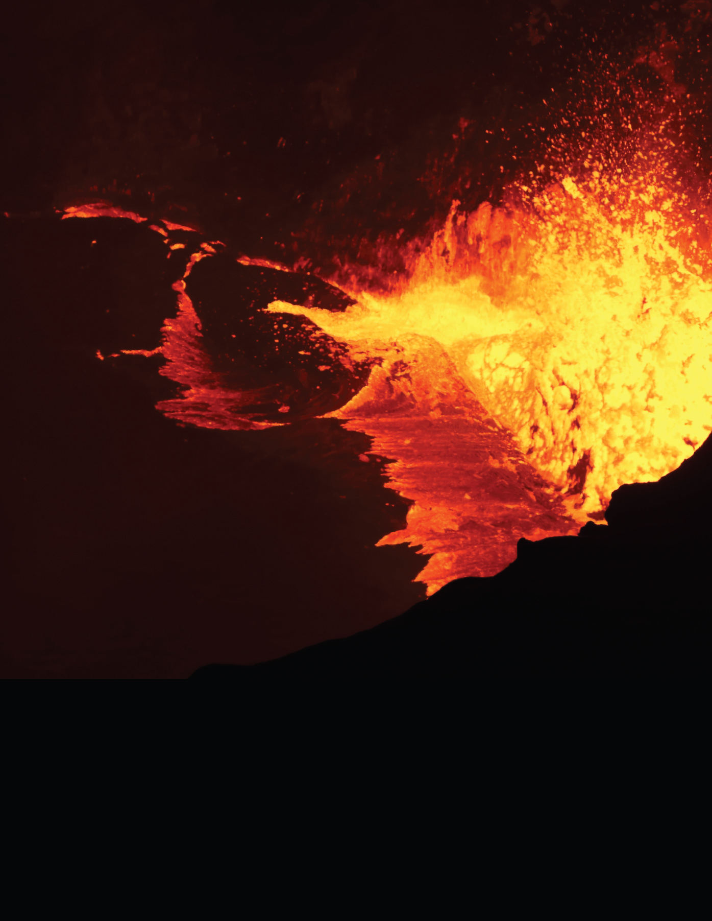
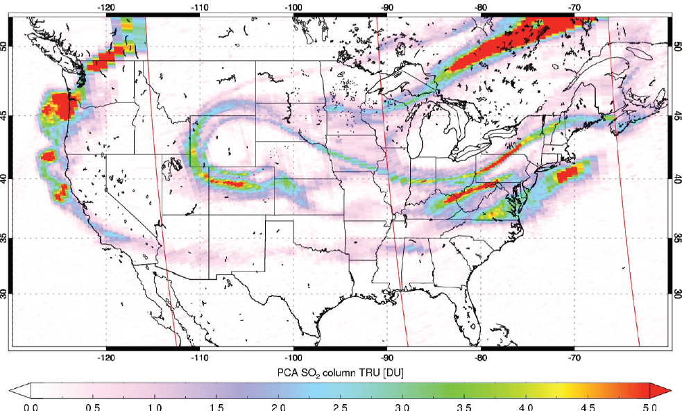
Volcanoes have enormous destructive power. Eruptions can change weather patterns, disrupt climate, and cause widespread human suffering and, in the past, mass extinctions. Globally, volcanic eruptions caused about 80,000 deaths during the 20th century (Sigurdsson et al., 2015). Even modest eruptions, such as the 2010 Eyjafjallajökull eruption in Iceland, have multibillion-dollar global impacts through disruption of air traffic. The 2014 steam explosion at Mount Ontake, Japan, killed 57 people without any magma reaching the surface. Many volcanoes in the United States have the potential for much larger eruptions, such as the 1912 eruption of Katmai, Alaska, the largest volcanic eruption of the 20th century (Hildreth and Fierstein, 2012). The 2008 eruption of the unmonitored Kasatochi volcano, Alaska, distributed volcanic gases over most of the continental United States within a week (Figure 1.1).
Finally, volcanoes are important economically. Volcanic heat provides low-carbon geothermal energy. U.S. generation of geothermal energy accounts for nearly one-quarter of the global capacity (Bertani, 2015). In addition, volcanoes act as magmatic and hydrothermal distilleries that create ore deposits, including gold and copper ores.
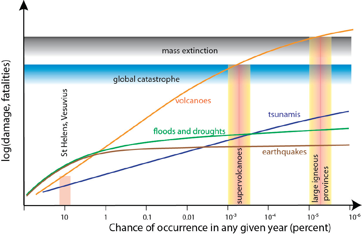
Moderate to large volcanic eruptions are infrequent yet high-consequence events. The impact of the largest possible eruption, similar to the super-eruptions at Yellowstone, Wyoming; Long Valley, California; or Valles Caldera, New Mexico, would exceed that of any other terrestrial natural event. Volcanoes pose the greatest natural hazard over time scales of several decades and longer, and at longer time scales they have the potential for global catastrophe (Figure 1.2). While
the continental United States has not suffered a fatal eruption since 1980 at Mount St. Helens, the threat has only increased as more people move into volcanic areas.
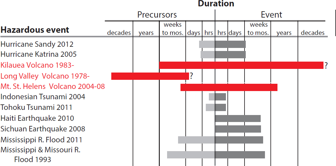
Volcanic eruptions evolve over very different temporal and spatial scales than most other natural hazards (Figure 1.3). In particular, many eruptions are preceded by signs of unrest that can serve as warnings, and an eruption itself often persists for an extended period of time. For example, the eruption of Kilauea Volcano in Hawaii has continued since 1983. We also know the locations of many volcanoes and, hence, where most eruptions will occur. For these reasons, the impacts of at least some types of volcanic eruptions should be easier to mitigate than other natural hazards.
Anticipating the largest volcanic eruptions is possible. Magma must rise to Earth’s surface and this movement is usually accompanied by precursors—changes in seismic, deformation, and geochemical signals that can be recorded by ground-based and space-borne instruments. However, depending on the monitoring infrastructure, precursors may present themselves over time scales that range from a few hours (e.g., 2002 Reventador, Ecuador, and 2015 Calbuco, Chile) to decades before eruption (e.g., 1994 Rabaul, Papua New Guinea). Moreover, not all signals of volcanic unrest are immediate precursors to surface eruptions (e.g., currently Long Valley, California, and Campi Flegrei, Italy).
Probabilistic forecasts account for this uncertainty using all potential eruption scenarios and all relevant data. An important consideration is that the historical record is short and biased. The instrumented record is even shorter and, for most volcanoes, spans only the last few decades—a miniscule fraction of their lifetime. Knowledge can be extended qualitatively using field studies of volcanic deposits, historical accounts, and proxy data, such as ice and marine sediment cores and speleothem (cave) records. Yet, these too are biased because they commonly do not record small to moderate eruptions.
Understanding volcanic eruptions requires contributions from a wide range of disciplines and approaches. Geologic studies play a critical role in reconstructing the past eruption history of volcanoes,
especially of the largest events, and in regions with no historical or directly observed eruptions. Geochemical and geophysical techniques are used to study volcano processes at scales ranging from crystals to plumes of volcanic ash. Models reveal essential processes that control volcanic eruptions, and guide data collection. Monitoring provides a wealth of information about the life cycle of volcanoes and vital clues about what kind of eruption is likely and when it may occur.
1.1 OVERVIEW OF THIS REPORT
At the request of managers at the National Aeronautics and Space Administration (NASA), the National Science Foundation, and the U.S. Geological Survey (USGS), the National Academies of Sciences, Engineering, and Medicine established a committee to undertake the following tasks:
- Summarize current understanding of how magma is stored, ascends, and erupts.
- Discuss new disciplinary and interdisciplinary research on volcanic processes and precursors that could lead to forecasts of the type, size, and timing of volcanic eruptions.
- Describe new observations or instrument deployment strategies that could improve quantification of volcanic eruption processes and precursors.
- Identify priority research and observations needed to improve understanding of volcanic eruptions and to inform monitoring and early warning efforts.
The roles of the three agencies in advancing volcano science are summarized in Box 1.1.
The committee held four meetings, including an international workshop, to gather information, deliberate, and prepare its report. The report is not intended to be a comprehensive review, but rather to provide a broad overview of the topics listed above. Chapter 2 addresses the opportunities for better understanding the storage, ascent, and eruption of magmas. Chapter 3 summarizes the challenges and prospects for forecasting eruptions and their consequences. Chapter 4 highlights repercussions of volcanic eruptions on a host of other Earth systems. Although not explicitly called out in the four tasks, the interactions between volcanoes and other Earth systems affect the consequences of eruptions, and offer opportunities to improve forecasting and obtain new insights into volcanic processes. Chapter 5 summarizes opportunities to strengthen
research in volcano science. Chapter 6 provides overarching conclusions. Supporting material appears in appendixes, including a list of volcano databases (see Appendix A), a list of workshop participants (see Appendix B), biographical sketches of the committee members (see Appendix C), and a list of acronyms and abbreviations (see Appendix D).
Background information on these topics is summarized in the rest of this chapter.
1.2 VOLCANOES IN THE UNITED STATES
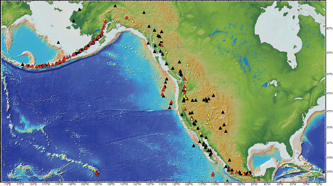
The USGS has identified 169 potentially active volcanoes in the United States and its territories (e.g., Marianas), 55 of which pose a high threat or very high threat (Ewert et al., 2005). Of the total, 84 are monitored by at least one seismometer, and only 3 have gas sensors (as of November 2016).1 Volcanoes are found in the Cascade mountains, Aleutian arc, Hawaii, and the western interior of the continental United States (Figure 1.4). The geographical extent and eruption hazards of these volcanoes are summarized below.
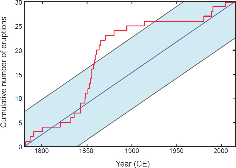
The Cascade volcanoes extend from Lassen Peak in northern California to Mount Meager in British Columbia. The historical record contains only small- to moderate-sized eruptions, but the geologic record reveals much larger eruptions (Carey et al., 1995; Hildreth, 2007). Activity tends to be sporadic (Figure 1.5). For example, nine Cascade eruptions occurred in the 1850s, but none occurred between 1915 and 1980, when Mount St. Helens erupted. Consequently, forecasting eruptions in the Cascades is subject to considerable uncertainty. Over the coming decades, there may be multiple eruptions from several volcanoes or no eruptions at all.
The Aleutian arc extends 2,500 km across the North Pacific and comprises more than 130 active and potentially active volcanoes. Although remote, these volcanoes pose a high risk to overflying aircraft that carry more than 30,000 passengers a day, and are monitored by a combination of ground- and space-based sensors. One or two small to moderate explosive eruptions occur in the Aleutians every year, and very large eruptions occur less frequently. For example, the world’s largest eruption of the 20th century occurred approximately 300 miles from Anchorage, in 1912.
In Hawaii, Kilauea has been erupting largely effusively since 1983, but the location and nature of eruptions can vary dramatically, presenting challenges for disaster preparation. The population at risk from large-volume, rapidly moving lava flows on the flanks of the Mauna Loa volcano has grown tremendously in the past few decades (Dietterich and Cashman, 2014), and few island residents are prepared for the even larger magnitude explosive eruptions that are documented in the last 500 years (Swanson et al., 2014).
All western states have potentially active volcanoes, from New Mexico, where lava flows have reached within a few kilometers of the Texas and Oklahoma borders (Fitton et al., 1991), to Montana, which borders the Yellowstone caldera (Christiansen, 1984). These volcanoes range from immense calderas that formed from super-eruptions (Mastin et al., 2014) to small-volume basaltic volcanic fields that erupt lava flows and tephra for a few months to a few decades. Some of these eruptions are monogenic (erupt just once) and pose a special challenge for forecasting. Rates of activity in these distributed volcanic fields are low, with many eruptions during the past few thousand years (e.g., Dunbar, 1999; Fenton, 2012; Laughlin et al., 1994), but none during the past hundred years.
1.3 THE STRUCTURE OF A VOLCANO
Volcanoes often form prominent landforms, with imposing peaks that tower above the surrounding landscape, large depressions (calderas), or volcanic fields with numerous dispersed cinder cones, shield volcanoes, domes, and lava flows. These various landforms reflect the plate tectonic setting, the ways in which those volcanoes erupt, and the number of eruptions. Volcanic landforms change continuously through the interplay between constructive processes such as eruption and intrusion, and modification by tectonics, climate, and erosion. The stratigraphic and structural architecture of volcanoes yields critical information on eruption history and processes that operate within the volcano.
Beneath the volcano lies a magmatic system that in most cases extends through the crust, except during eruption. Depending on the setting, magmas may rise
___________________
1 Personal communication from Charles Mandeville, Program Coordinator, Volcano Hazards Program, U.S. Geological Survey, on November 26, 2016.
directly from the mantle or be staged in one or more storage regions within the crust before erupting. The uppermost part (within 2–3 km of Earth’s surface) often hosts an active hydrothermal system where meteoric groundwater mingles with magmatic volatiles and is heated by deeper magma. Identifying the extent and vigor of hydrothermal activity is important for three reasons: (1) much of the unrest at volcanoes occurs in hydrothermal systems, and understanding the interaction of hydrothermal and magmatic systems is important for forecasting; (2) pressure buildup can cause sudden and potentially deadly phreatic explosions from the hydrothermal system itself (such as on Ontake, Japan, in 2014), which, in turn, can influence the deeper magmatic system; and (3) hydrothermal systems are energy resources and create ore deposits.
Below the hydrothermal system lies a magma reservoir where magma accumulates and evolves prior to eruption. Although traditionally modeled as a fluid-filled cavity, there is growing evidence that magma reservoirs may comprise an interconnected complex of vertical and/or horizontal magma-filled cracks, or a partially molten mush zone, or interleaved lenses of magma and solid material (Cashman and Giordano, 2014). In arc volcanoes, magma chambers are typically located 3–6 km below the surface. The magma chamber is usually connected to the surface via a fluid-filled conduit only during eruptions. In some settings, magma may ascend directly from the mantle without being stored in the crust.
In the broadest sense, long-lived magma reservoirs comprise both eruptible magma (often assumed to contain less than about 50 percent crystals) and an accumulation of crystals that grow along the margins or settle to the bottom of the magma chamber. Physical segregation of dense crystals and metals can cause the floor of the magma chamber to sag, a process balanced by upward migration of more buoyant melt. A long-lived magma chamber can thus become increasingly stratified in composition and density.
The deepest structure beneath volcanoes is less well constrained. Swarms of low-frequency earthquakes at mid- to lower-crustal depths (10–40 km) beneath volcanoes suggest that fluid is periodically transferred into the base of the crust (Power et al., 2004). Tomographic studies reveal that active volcanic systems have deep crustal roots that contain, on average, a small fraction of melt, typically less than 10 percent. The spatial distribution of that melt fraction, particularly how much is concentrated in lenses or in larger magma bodies, is unknown. Erupted samples preserve petrologic and geochemical evidence of deep crystallization, which requires some degree of melt accumulation. Seismic imaging and sparse outcrops suggest that the proportion of unerupted solidified magma relative to the surrounding country rock increases with depth and that the deep roots of volcanoes are much more extensive than their surface expression.
1.4 MONITORING VOLCANOES
Volcano monitoring is critical for hazard forecasts, eruption forecasts, and risk mitigation. However, many volcanoes are not monitored at all, and others are monitored using only a few types of instruments. Some parameters, such as the mass, extent, and trajectory of a volcanic ash cloud, are more effectively measured by satellites. Other parameters, notably low-magnitude earthquakes and volcanic gas emissions that may signal an impending eruption, require ground-based monitoring on or close to the volcanic edifice. This section summarizes existing and emerging technologies for monitoring volcanoes from the ground and from space.
Monitoring Volcanoes on or Near the Ground
Ground-based monitoring provides data on the location and movement of magma. To adequately capture what is happening inside a volcano, it is necessary to obtain a long-term and continuous record, with periods spanning both volcanic quiescence and periods of unrest. High-frequency data sampling and efficient near-real-time relay of information are important, especially when processes within the volcano–magmatic–hydrothermal system are changing rapidly. Many ground-based field campaigns are time intensive and can be hazardous when volcanoes are active. In these situations, telemetry systems permit the safe and continuous collection of data, although the conditions can be harsh and the lifetime of instruments can be limited in these conditions.
Ground-based volcano monitoring falls into four broad categories: seismic, deformation, gas, and thermal monitoring (Table 1.1). Seismic monitoring tools,
TABLE 1.1 Ground-Based Instrumentation for Monitoring Volcanoes
| Measurement | Instrument | Purpose |
|---|---|---|
| Seismic waves | Geophone | Detect lahars (volcanic mudflows) and pyroclastic density currents |
| Short-period seismometer | Locate earthquakes, study earthquake mechanics, and detect unrest | |
| Broadband seismometer | Study earthquakes, tremor, and long-period earthquakes to quantify rock failure, fluid movement, and eruption progress | |
| Infrasound detector | Track evolution of near-surface eruptive activity | |
| Geodetic | Classical surveying techniques | Detect deformation over broad areas |
| Tiltmeter | Detect subtle pressurization or volumetric sources | |
| Strainmeter | Detect changing stress distributions | |
| GNSS/Global Positioning System | Model intrusion locations and sizes, detect ash clouds | |
| Photogrammetic and structure from motion | Map and identify or measure morphologic changes | |
| Lidar | Precision mapping, detect ash and aerosol heights | |
| Radar | Quantify rapid surface movements and velocities of ballistic pyroclasts | |
| Gas | Miniature differential optical absorption spectrometer | Detect sulfur species concentrations and calculate gas flux |
| Open-path Fourier transform infrared spectroscopy | Quantify gas concentration ratios | |
| Ultraviolet imagers | Detect plume sulfur | |
| Gigenbach-type sampling and multiGAS sensors | Determine chemical and isotopic compositions and make in situ measurements of gas species | |
| Portable laser spectrometer | Measure stable isotopic ratios of gases | |
| Thermal | Infrared thermal camera | Detect dome growth, lava breakouts, and emissions of volcanic ash and gas |
| In situ thermocouple | Monitor fumarole temperatures | |
| Hydrologic | Temperature probe | Detect changes in hydrothermal sources |
| Discharge measurements | Detect changes in pressure or permeability | |
| Sampling for chemical and isotopic composition | Detect magma movement | |
| Potential fields | Gravimeter | Detect internal mass movement |
| Self-potential, resistivity | Detect fluids and identify fractures and voids | |
| Magnetotellurics | 3D location of fluids and magma in shallow crust | |
| Other | Cosmic ray muon detector | Tomography |
| High-speed camera | Image explosion dynamics | |
| Drones | Visually observe otherwise inaccessible surface phenomena | |
| Lightning detection array | Locate lightning and identify ash emissions |
including seismometers and infrasound sensors, are used to detect vibrations caused by breakage of rock and movement of fluids and to assess the evolution of eruptive activity. Ambient seismic noise monitoring can image subsurface reservoirs and document changes in wave speed that may reflect stress. changes. Deformation monitoring tools, including tiltmeters, borehole strainmeters, the Global Navigation Satellite System (GNSS, which includes the Global Positioning System [GPS]), lidar, radar, and gravimeters, are used to detect the motion of magma and other fluids in the subsurface. Some of these tools, such as GNSS and lidar, are also used to detect erupted products, including ash clouds, pyroclastic density currents, and volcanic bombs. Gas monitoring tools, including a range of sensors (Table 1.1), and direct sampling of gases and fluids are used to detect magma intrusions and changes in magma–hydrothermal interactions. Thermal monitoring tools, such as infrared cameras, are used to detect dome growth and lava breakouts. Continuous video or photographic observations are also commonly used and, despite their simplicity, most directly document volcanic activity. Less commonly used monitoring technologies, such as self-potential, electromagnetic techniques, and lightning detection are used to constrain fluid movement and to detect
ash clouds. In addition, unmanned aerial vehicles (e.g., aircraft and drones) are increasingly being used to collect data. Rapid sample collection and analysis is also becoming more common as a monitoring tool at volcano observatories. A schematic of ground-based monitoring techniques is shown in Figure 1.6.
Monitoring Volcanoes from Space
Satellite-borne sensors and instruments provide synoptic observations during volcanic eruptions when collecting data from the ground is too hazardous or where volcanoes are too remote for regular observation. Repeat-pass data collected over years or decades provide a powerful means for detecting surface changes on active volcanoes. Improvements in instrument sensitivity, data availability, and the computational capacity required to process large volumes of data have led to a dramatic increase in “satellite volcano science.”
Although no satellite-borne sensor currently in orbit has been specifically designed for volcano monitoring, a number of sensors measure volcano-relevant
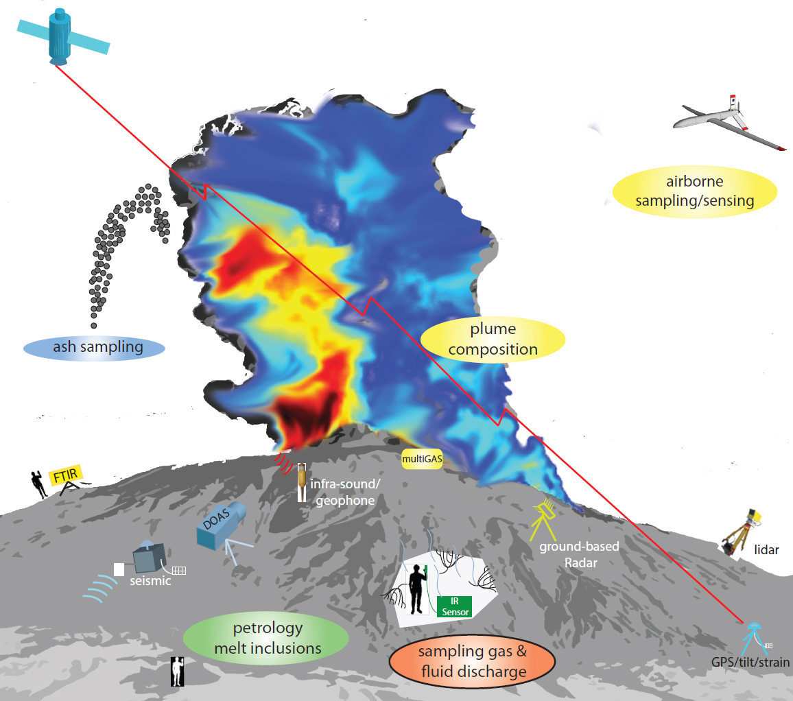
TABLE 1.2 Satellite-Borne Sensor Suite for Volcano Monitoring
| Measurement | Purpose | Examples |
|---|---|---|
| High-temporal/low-spatial-resolution multispectral thermal infrared | Detect eruptions and map ash clouds | GOES |
| Low-temporal/moderate-spatial-resolution multispectral thermal infrared | Detect eruptions and map ash clouds with coverage of high latitudes; infer lava effusion rate | AVHRR, MODIS |
| Low-temporal/high-spatial-resolution multispectral visible infrared | Map detailed surface and plumes; infer lava effusion rate | Landsat, ASTER, Sentinel-2 |
| Hyperspectral ultraviolet | Detect and quantify volcanic SO2, BrO, and OClO | OMI |
| Hyperspectral infrared | Detect and quantify volcanic SO2 and H2S in nighttime and winter | IASI, AIRS |
| Microwave limb sounding | Detect volcanic SO2 and HCl in the upper troposphere and stratosphere | MLS |
| Visible–near-infrared multiangle imaging | Determine volcanic ash cloud altitudes and plume speed | MISR |
| Ultraviolet–visible limb scattering | Measure aerosol vertical profiles | OMPS-LP |
| Ultraviolet–near-infrared solar occultation | Measure stratospheric aerosol | SAGE III |
| Spaceborne lidar | Develop vertical profiles of volcanic clouds | CALIPSO |
| Spaceborne W-band radar | Measure volcanic hydrometeors | CloudSat |
| Multiband (X-, C-, L-band) synthetic aperture radar | Measure deformation globally | Sentinel-1a/b, ALOS-2, COSMO-SkyMed, TerraSAR-X, TanDEM-X, Radarsat-2 |
NOTE: AIRS, Atmospheric Infrared Sounder; ALOS, Advanced Land Observing Satellite; ASTER, Advanced Spaceborne Thermal Emission and Reflection Radiometer; AVHRR, Advanced Very High Resolution Radiometer; CALIPSO, Cloud-Aerosol Lidar and Infrared Pathfinder Satellite Observation; COSMO-SkyMed, Constellation of Small Satellites for Mediterranean Basin Observation; GOES, Geostationary Operational Environmental Satellite; IASI, Infrared Atmospheric Sounding Interferometer; MISR, Multi-angle Imaging SpectroRadiometer; MLS, Microwave Limb Sounder; MODIS, Moderate Resolution Imaging Spectroradiometer; OMI, Ozone Monitoring Instrument; OMPS, Ozone Mapping and Profiler Suite; SAGE, Stratospheric Aerosol and Gas Experiment.
parameters, including heat flux, gas and ash emissions, and deformation (Table 1.2). Thermal infrared data are used to detect eruption onset and cessation, calculate lava effusion rates, map lava flows, and estimate ash column heights during explosive eruptions. In some cases, satellites may capture thermal precursors to eruptions, although low-temperature phenomena are challenging to detect. Both high-temporal/low-spatial-resolution (geostationary orbit) and high-spatial/low-temporal-resolution (polar orbit) thermal infrared observations are needed for global volcano monitoring.
Satellite-borne sensors are particularly effective for observing the emission and dispersion of volcanic gas and ash plumes in the atmosphere. Although several volcanic gas species can be detected from space (including SO2, BrO, OClO, H2S, HCl, and CO; Carn et al., 2016), SO2 is the most readily measured, and it is also responsible for much of the impact of eruptions on climate. Satellite measurements of SO2 are valuable for detecting eruptions, estimating global volcanic fluxes and recycling of other volatile species, and tracking volcanic clouds that may be hazardous to aviation in near real time. Volcanic ash cloud altitude is most accurately determined by spaceborne lidar, although spatial coverage is limited. Techniques for measuring volcanic CO2 from space are under development and could lead to earlier detection of preeruptive volcanic degassing.
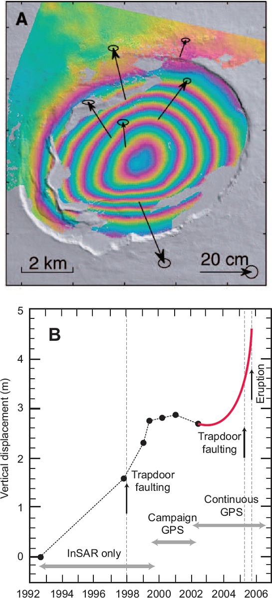
Interferometric synthetic aperture radar (InSAR) enables global-scale background monitoring of volcano deformation (Figure 1.7). InSAR provides much higher spatial resolution than GPS, but lower accuracy and temporal resolution. However, orbit repeat times will diminish as more InSAR missions are launched, such as the European Space Agency’s recently deployed Sentinel-1 satellite and the NASA–Indian Space Research Organisation synthetic aperture radar mission planned for launch in 2020.
1.5 ERUPTION BEHAVIOR
Eruptions range from violently explosive to gently effusive, from short lived (hours to days) to persistent over decades or centuries, from sustained to intermittent, and from steady to unsteady (Siebert et al., 2015). Eruptions may initiate from processes within the magmatic system (Section 1.3) or be triggered by processes and properties external to the volcano, such as precipitation, landslides, and earthquakes. The eruption behavior of a volcano may change over time. No classification scheme captures this full diversity of behaviors (see Bonadonna et al., 2016), but some common schemes to describe the style, magnitude, and intensity of eruptions are summarized below.
Eruption Magnitude and Intensity
The size of eruptions is usually described in terms of total erupted mass (or volume), often referred to as magnitude, and mass eruption rate, often referred to as intensity. Pyle (2015) quantified magnitude and eruption intensity as follows:
magnitude = log10 (mass, in kg) – 7, and
intensity = log10 (mass eruption rate, in kg/s) + 3.
The Volcano Explosivity Index (VEI) introduced by Newhall and Self (1982) assigns eruptions to a VEI class based primarily on measures of either magnitude (erupted mass or volume) or intensity (mass eruption rate and/or eruption plume height), with more weight given to magnitude. The VEI classes are summarized in Figure 1.8. The VEI classification is still in use, despite its many limitations, such as its reliance on only a few types of measurements and its poor fit for small to moderate eruptions (see Bonadonna et al., 2016).
Smaller VEI events are relatively common, whereas larger VEI events are exponentially less frequent (Siebert et al., 2015). For example, on average about three VEI 3 eruptions occur each year, whereas there is a 5 percent chance of a VEI 5 eruption and a 0.2 percent chance of a VEI 7 (e.g., Crater Lake, Oregon) event in any year.
Eruption Style
The style of an eruption encompasses factors such as eruption duration and steadiness, magnitude, gas flux, fountain or column height, and involvement of magma and/or external source of water (phreatic and phreatomagmatic eruptions). Eruptions are first divided into effusive (lava producing) and explosive (pyroclast producing) styles, although individual eruptions can be simultaneously effusive and weakly explosive, and can pass rapidly and repeatedly between eruption styles. Explosive eruptions are further subdivided into styles that are sustained on time scales of hours to days and styles that are short lived (Table 1.3).
Classification of eruption style is often qualitative and based on historical accounts of characteristic eruptions from type-volcanoes. However, many type-volcanoes exhibit a range of eruption styles over time (e.g., progressing between Strombolian, Vulcanian, and Plinian behavior; see Fee et al., 2010), which has given rise to terms such as subplinian or violent Strombolian.
1.6 ERUPTION HAZARDS
Eruption hazards are diverse (Figure 1.9) and may extend more than thousands of kilometers from an active volcano. From the perspective of risk and impact, it is useful to distinguish between near-source and distal hazards. Near-source hazards are far more unpredictable than distal hazards.
Near-source hazards include those that are airborne, such as tephra fallout, volcanic gases, and volcanic projectiles, and those that are transported laterally on or near the ground surface, such as pyroclastic density currents, lava flows, and lahars. Pyroclastic density currents are hot volcanic flows containing mixtures of gas and micron- to meter-sized volcanic particles. They can travel at velocities exceeding 100 km per hour. The heat combined with the high density of material within these flows obliterates objects in their path, making them the most destructive of volcanic hazards. Lava flows also destroy everything in their path, but usually move slowly enough to allow people to get out of the way. Lahars are mixtures of volcanic debris, sediment, and water that can travel many tens of kilometers along valleys and river channels. They may be triggered during an eruption by interaction between volcanic prod-
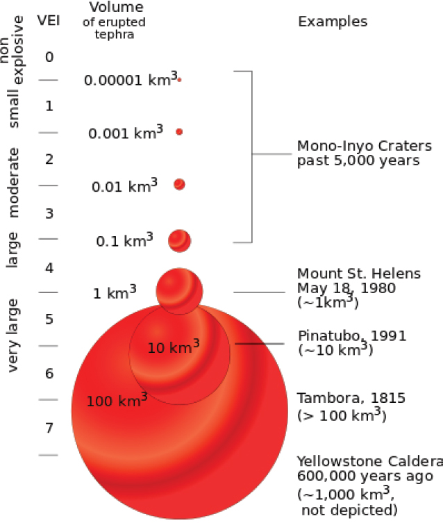
TABLE 1.3 Characteristics of Different Eruption Styles
| Eruption Style | Characteristics |
|---|---|
| Hawaiian | Sustained fountaining of magmatic gas and pyroclasts (up to ~1,000 m) often generating clastogenic, gas-charged lava flows from single vents or from fissures |
| Strombolian | Short-duration, low-vigor, episodic, small (<100s of meters) explosions driven by escape of pockets of gas and ejecting some bombs and spatter |
| Vulcanian | Short-duration, moderately vigorous, magma-fragmenting explosions producing ash-rich columns that may reach heights >1,000 m |
| Surtseyan | Short duration, weak phreatomagmatic explosive eruptions where fluid magma interacts with standing water |
| Phreatoplinian | Prolonged powerful phreatomagmatic explosions where viscous magma interacts with surface water or groundwater |
| Dome collapse | Dome collapse pyroclastic flows occur at unstable gas-charged domes either with an explosive central column eruption (e.g., Mount Pelee) or without (e.g., Unzen, Montserrat, and Santiaguito) |
| Plinian | Very powerful, sustained eruptions with columns reaching the stratosphere (>15 km) and sometimes generating large pyroclastic density currents from collapsing eruption columns |
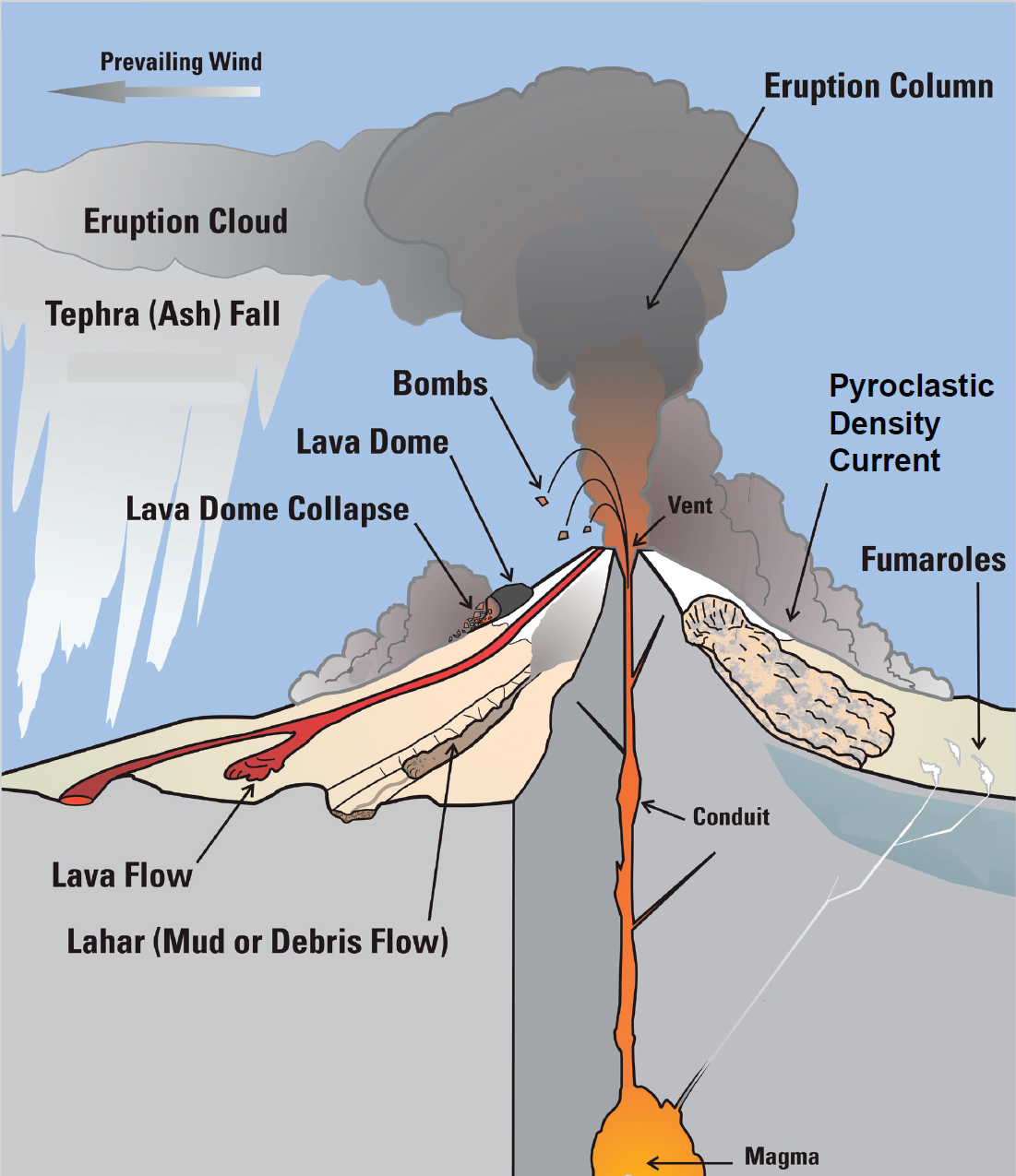
ucts and snow, ice, rain, or groundwater. Lahars can be more devastating than the eruption itself. Ballistic blocks are large projectiles that typically fall within 1–5 km from vents.
The largest eruptions create distal hazards. Explosive eruptions produce plumes that are capable of dispersing ash hundreds to thousands of kilometers from the volcano. The thickness of ash deposited depends on the intensity and duration of the eruption and the wind direction. Airborne ash and ash fall are the most severe distal hazards and are likely to affect many more people than near-source hazards. They cause respiratory problems and roof collapse, and also affect transport networks and infrastructure needed to support emergency response. Volcanic ash is a serious risk to air traffic. Several jets fully loaded with passengers have temporarily lost power on all engines after encountering dilute ash clouds (e.g., Guffanti et al., 2010). Large lava flows, such as the 1783 Laki eruption in Iceland, emit volcanic gases that create respiratory problems and acidic rain more than 1,000 km from the eruption. Observed impacts of basaltic eruptions in Hawaii and Iceland include regional volcanic haze (“vog”) and acid rain that affect both agriculture and human health (e.g., Thordarson and Self, 2003) and fluorine can contaminate grazing land and water supplies (e.g., Cronin et al., 2003). Diffuse degassing of CO2 can lead to deadly concentrations with fatal consequences such as occurred at Mammoth Lakes, California, or cause lakes to erupt, leading to massive CO2 releases that suffocate people (e.g., Lake Nyos, Cameroon).
Secondary hazards can be more devastating than the initial eruption. Examples include lahars initiated by storms, earthquakes, landslides, and tsunamis from eruptions or flank collapse; volcanic ash remobilized by wind to affect human health and aviation for extended periods of time; and flooding because rain can no longer infiltrate the ground.
1.7 MODELING VOLCANIC ERUPTIONS
Volcanic processes are governed by the laws of mass, momentum, and energy conservation. It is possible to develop models for magmatic and volcanic phenomena based on these laws, given sufficient information on mechanical and thermodynamic properties of the different components and how they interact with each other. Models are being developed for all processes in volcanic systems, including melt transport in the mantle, the evolution of magma bodies within the crust, the ascent of magmas to the surface, and the fate of magma that erupts effusively or explosively.
A central challenge for developing models is that volcanic eruptions are complex multiphase and multicomponent systems that involve interacting processes over a wide range of length and time scales. For example, during storage and ascent, the composition, temperature, and physical properties of magma and host rocks evolve. Bubbles and crystals nucleate and grow in this magma and, in turn, greatly influence the properties of the magmas and lavas. In explosive eruptions, magma fragmentation creates a hot mixture of gas and particles with a wide range of sizes and densities. Magma also interacts with its surroundings: the deformable rocks that surround the magma chamber and conduit, the potentially volatile groundwater and surface water, a changing landscape over which pyroclastic density currents and lava flows travel, and the atmosphere through which eruption columns rise.
Models for volcanic phenomena that involve a small number of processes and that are relatively amenable to direct observation, such as volcanic plumes, are relatively straightforward to develop and test. In contrast, phenomena that occur underground are more difficult to model because there are more interacting processes. In those cases, direct validation is much more challenging and in many cases impossible. Forecasting ash dispersal using plume models is more straightforward and testable than forecasting the onset, duration, and style of eruption using models that seek to explain geophysical and geochemical precursors. In all cases, however, the use of even imperfect models helps improve the understanding of volcanic systems.
Modeling approaches can be divided into three categories:
- Reduced models make simplifying assumptions about dynamics, heat transfer, and geometry to develop first-order explanations for key properties and processes, such as the velocity of lava flows and pyroclastic density currents, the height of eruption columns, the magma chamber size and depth, the dispersal of tephra, and the ascent of magma in conduits. Well-calibrated or tested reduced models offer a straightforward ap-
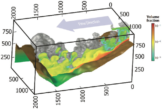
- Multiphase and multiphysics models improve scientific understanding of complex processes by invoking fewer assumptions and idealizations than reduced models (Figure 1.10), but at the expense of increased complexity and computational demands. They also require additional components, such as a model for how magma in magma chambers and conduits deforms when stressed; a model for turbulence in pyroclastic density currents and plumes; terms that describe the thermal and mechanical exchange among gases, crystals, and particles; and a description of ash aggregation in eruption columns. A central challenge for multiphysics models is integrating small-scale processes with large-scale dynamics. Many of the models used in volcano science build on understanding developed in other science and engineering fields and for other ap-
proach for combining observations and models in real time in an operational setting (e.g., ash dispersal forecasting for aviation safety). Models may not need to be complex if they capture the most important processes, although simplifications require testing against more comprehensive models and observations.
-
plications. Multiphysics and multiscale models benefit from rapidly expanding computational capabilities.
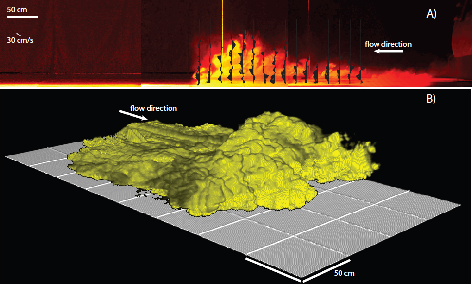
- Laboratory experiments simulate processes for which the geometry and physical and thermal processes and properties can be scaled (Mader et al., 2004). Such experiments provide insights on fundamental processes, such as crystal dynamics in flowing magmas, entrainment in eruption columns, propagation of dikes, and sedimentation from pyroclastic density currents (Figure 1.11). Experiments have also been used successfully to develop the subsystem models used in numerical simulations, and to validate computer simulations for known inputs and properties.
The great diversity of existing models reflects to a large extent the many interacting processes that operate in volcanic eruptions and the corresponding simplifying assumptions currently required to construct such models. The challenge in developing models is often highlighted in discrepancies between models and observations of natural systems. Nevertheless, eruption models reveal essential processes governing volcanic eruptions, and they provide a basis for interpreting measurements from prehistoric and active eruptions and for closing observational gaps. Mathematical models offer a guide for what observations will be most useful. They may also be used to make quantitative and testable predictions, supporting forecasting and hazard assessment.