


Below is the uncorrected machine-read text of this chapter, intended to provide our own search engines and external engines with highly rich, chapter-representative searchable text of each book. Because it is UNCORRECTED material, please consider the following text as a useful but insufficient proxy for the authoritative book pages.
15-13 effects of all urban form parameters may be substantial. The research utilizing San Francisco Bay Area survey data found elasticities for VMT per household of -0.31 for accessibility, and -0.10 each for land use balance and fine-grained mix, along with +0.56 for autos owned, through which small density effects were channeled. Lower household VMT is also associated with location nearer the CBD; and as identified in greater Toronto, nearer major employment centers well served by transit. Good accessibility to jobs has also been found to be negatively correlated with VMT in Seattle, as has neighborhood shopping with good pedestrian access in the San Francisco Bay Area. Much as trip lengths are typically shorter in areas with jobs-housing balance, so are household VMT averages lower. In San Francisco Bay Area cities with a high surplus of jobs, workers selected the drive-alone mode 5 percent more often, encountered commute times 11 percent longer, and produced commute VMT per employee 7 percent higher than in other cities. VMT reductions or equivalent differentials on the order of 10 percent have been estimated for use of TND versus conventional PUD local street design, and for very pedestrian-friendly environments within Portland, Oregon, versus average environments. Average daily travel mileage in Seattle area mixed use neighborhoods has been found to be 10 to 25 percent less than in the corresponding subregional areas. It may be safely presumed that the VMT differential would be at least as large. Among six Florida communities, households in the one with the highest density/accessibility produced almost 40 percent less vehicle hours of travel than in the one with the lowest. San Francisco Bay Area paired community analysis indicated average daily VMT per resident was 45 percent less in the TND neighborhood than in the CSD area, with its large-block, auto-oriented suburban fabric and further-out location. RESPONSE BY TYPE OF STRATEGY This synthesis of traveler response to land use and site design features is subdivided according to the â3 Dsâ into âDensity,â âDiversity (Land Use Mix),â and âSite Designâ subsections, presented in that order. In addition to the encapsulated bringing-together of the findings by type of effect in the preceding âTraveler Response Summary,â individual types of impacts are also examined jointly in the âRelated Information and Impactsâ section of this chapter, most notably under âTrip Making and VMTâ and the subsections that follow. Density Density of development received the most attention early on in investigation of relationships between land use and transportation. The intuitive appeal of a relationship between density and travel behavior is reinforced by observable trends. For example, transit use is generally greater in the older, higher density cities of the northeast. Mental images of New York City, shaped by familiarity with Manhattan, portray an extremely high-density environment where autos are out of place for all but limited needs. Conversely, picturing Los Angeles conveys the image of sprawl and auto dependency. The relationship between urban form and travel is much more complex than intuitive thought would imply, however, even for what would appear to be the polar opposites represented by New York City and Los Angeles. Much depends on all the factors which characterize urban form in determining the nature of a link between land use and travel. These include not only density, mixture of uses, and balance and design, but also other
15-14 aspects of an area including its suburbs, its people and their socio-economic characteristics, and its transportation features. After a brief look at density from the macro-perspective of metropolitan region totals, a behavioral level review follows. First examined is research that has allowed âdensityâ to subsume most or all characteristics historically associated with it, factors that other researchers would assign to other land use and urban design features, or even to socio- demographic or transportation system attributes. Then density is looked at in conjunction with other land use and demographic and transportation attributes, focusing on the direct impacts of density isolated as best possible from other urban and population features. Finally its special relationship to transit use and feasibility is examined. Density a t the Metropo litan Area Level Observing relationships between land area, population and rates of travel at a macro- aggregate level, while it must be done with caution, offers some insight into the potential importance of density. Table 15-2 presents data from the Federal Highway Administrationâs (FHWAâs) Highway Statistics database (FHWA, 2000), providing an overview of population, land area, highway intensity, and travel in the 15 largest U.S. urbanized areas along with selected examples of the 50 next largest areas. Figure 15-1 shows a scatter plot made with the urbanized area population density data for all 65 of the largest U.S. urbanized areas, relating 1998 daily vehicle miles of travel (DVMT) per capita to the density values. Although the data suffer from land area definitional oddities, corresponding inconsistencies, and lack of depth such as would be provided by income information, the chart still shows a fairly clear inverse relationship between density and vehicle use. Cities such as Houston, Atlanta, and Jacksonville, which are newer, auto-oriented places, are clearly represented in the low-density/high DVMT section of the graph (upper left quadrant). Older, transit- influenced cities, such as New York and Philadelphia, appear at the lower right of the graph, among other high-density/lower DVMT examples. Beyond that general tendency, however, the anomalies of the chart command interest, though some may be attributable to the data limitations. Metropolitan Los Angeles, at least as defined in this FHWA dataset, turns out to have one of the highest population densities (5,648 persons/square mile) of all urban areas, higher even than Northeastern New Jersey and New York (4,140), metropolitan Philadelphia (3,367), or Chicago and Northwestern Indiana (2,956). Differences in suburban densities are a major factor â high suburban densities characterize Los Angeles County, for example. While Los Angelesâs rate of vehicular travel (21.7 DVMT/capita) is higher than for those three big transit regions, it is only slightly higher than their range of 15.7 to 19.7 DVMT/capita, and certainly not on a par with Atlanta (35.8) or Houston (38.4). Perhaps even more interesting is that Los Angelesâs DVMT/capita rate is comparable to those for the urban areas of San Francisco (21.2) and Portland, Oregon (21.1) â one with an historically high- density core, the other a paragon of land use management â while being considerably lower than Seattleâs (25.5) or Milwaukeeâs (25.4 DVMT/capita).
15-15 Table 15-2 Population, Land Area, DVMT, and Road System Characteristics of the 15 Largest â and 15 Selected Additional â U.S. Urbanized Areas, 1998 State Location Federal-Aid Urbanized Area (Federal Highway Administration) Pri- mary Other Esti- mated Popu- lation (1,000) Net Land Area (Square Miles) Persons per Square Mile Total DVMT (Daily VMT) (1,000) Total DVMT per Capita Total Road- way Miles Miles of Road- way per 1,000 Persons New York-NEastern NJ NY NJ 16,407 3,962 4,141 257,040 15.7 37,580 2.3 Los Angeles CA 12,600 2,231 5,648 273,161 21.7 26,716 2.1 Chicago-NWestern IN IL IN 8,070 2,730 2,956 159,107 19.7 23,698 2.9 Philadelphia PA NJ 4,546 1,350 3,367 76,464 16.8 13,389 2.9 San Francisco-Oakland CA 4,017 1,203 3,339 85,039 21.2 9,323 2.3 Detroit MI 3,852 1,304 2,954 88,802 23.1 12,945 3.4 Dallas-Fort Worth TX 3,722 1,712 2,174 108,543 29.2 17,868 4.8 Washington DC MD, VA 3,442 999 3,445 81,642 23.7 10,212 3.0 Boston MA 2,904 1,138 2,552 59,540 20.5 10,125 3.5 Atlanta GA 2,806 1,757 1,597 100,460 35.8 13,005 4.6 San Diego CA 2,683 733 3,660 57,625 21.5 5,926 2.2 Phoenix AZ 2,482 1,054 2,355 53,396 21.5 9,556 3.9 Houston TX 2,396 1,537 1,559 91,925 38.4 15,497 6.5 Minneapolis-St. Paul MN 2,322 1,192 1,948 56,256 24.2 10,704 4.6 Baltimore MD 2,107 712 2,959 44,136 20.9 6,532 3.1 Seattle WA 1,980 844 2,346 50,578 25.5 6,938 3.5 Denver CO 1,828 720 2,539 41,043 22.5 6,843 3.7 Portland-Vancouver OR WA 1,471 468 3,143 31,091 21.1 5,534 3.8 Kansas City MO KS 1,375 1,034 1,330 40,145 29.2 7,542 5.5 Milwaukee WI 1,243 512 2,428 31,622 25.4 5,023 4.0 Buffalo-Niagara Falls NY 1,072 564 1,901 20,269 18.9 3,968 3.7 New Orleans LA 1,065 269 3,959 15,368 14.4 3,285 3.1 Oklahoma City OK 1,030 711 1,449 25,150 24.4 4,639 4.5 Indianapolis IN 915 422 2,168 28,208 30.8 4,191 4.6 Jacksonville FL 839 727 1,154 23,346 27.8 3,664 4.4 Birmingham AL 659 609 1,082 22,444 34.1 4,585 7.0 Charlotte NC 624 299 2,087 17,003 27.2 2,562 4.1 Nashville TN 618 571 1,082 22,296 36.1 2,960 4.8 Hartford-Middletown CT 591 366 1,615 15,309 25.9 2,579 4.4 Sarasota-Bradenton FL 512 464 1,103 9,088 17.8 2,059 4.0 Notes: The 15 selected additional areas are example regions from among the next 50 largest areas, averaging essentially the same DVMT per capita as the universe of all 50. Some of the urbanized area data are inconsistently reported, for example, the Pennsylvania portion of Wilmington, DE (not one of the 65 largest areas) is reported in with Philadelphia. Source: Extracted from FHWA (2000)
15-16 Figure 15-1 Daily vehicle miles of travel versus population density in the 65 largest U.S. urbanized areas â 1998 Source: Plot of data presented in FHWA (2000).
15-17 What these numbers illustrate is that, in general, places with higher densities do tend to have less reliance on auto travel. However, the anomalies cited in connection with Figure 15-1 provide ample evidence that there is more to the link between land use, urban form and travel behavior than can be explained by aggregate densities alone. To begin to understand what differentiates these urban areas, one needs to look also at such factors as highway mileage and coverage, level and type of transit service, social and economic differences, topography, and all the way down to how communities and neighborhoods are laid out and connected. It must also be recognized that many of the older âtransitâ cities, while high density at their core, have realized most of their post-WW II growth in outlying low density areas. Coupled with exodus from central cities, this has led to a downward trend in both regional densities and transit use. One of the most significant factors in national VMT growth is thought to have been this population and employment shift to the suburbs of large metropolitan areas (NTI, 2000). The threefold outstripping of population growth by VMT growth in the United States between 1980 and 1996 is documented and interpreted in the âRelated Information and Impactsâ section of this chapter under âTrip Making and VMT.â The trend toward dispersal and lower densities has been seen from divergent perspectives: by some as actually a solution to urban mobility problems, but by more as a formula for traffic congestion and gridlock (Gordon and Richardson, 1997; Ewing, 1997). The existence of a link between land use density and travel, and the extent and direction of causality, has likewise been much debated. The nature of linkage between density and travel is further probed in the remainder of this âResponse by Type of Strategyâ â âDensityâ section, relying as much as possible on investigations using subregional data aggregations or disaggregate data, with a primary focus on travel behavior effects. Density a t the Behaviora l Level Table 15-3 encapsulates selected studies of the link between density and travel behavior, along with their key findings, focusing on those that have either treated density as the primary land use indicator or have concentrated on isolating its effects. Some of the studies are expanded upon in the text that follows, or elsewhere in this chapter, where noted in the first column of the table. In general, the research confirms an association between density and vehicle travel. At higher densities, use of alternative modes â particularly transit and pedestrian travel â is higher. Per-capita passenger vehicle trips and VMT are lower. When density is treated as being inclusive of related phenomena, the relationship is quite strong. However, the extent of the direct causal role played by density itself, when analytic approaches have tried to isolate it, seems fairly modest. Typical elasticities for vehicular travel with respect to density narrowly defined are perhaps -0.1 to -0.05, keeping related phenomena separate (NTI, 2000; Ewing and Cervero, 2001). Not to be overlooked when isolating density from related phenomena, however, is its role as a precondition for higher levels of land use mix and transit service. With lower density there is less of a market â often not enough market at all â for the commerce that creates mix or the transit riding that provides minimum levels of support for frequent and traffic-free transit services.
15-18 Table 15-3 Summary of Research Findings on Relationship of Density (as Prime Indicator) with Travel Behavior Study (Date) Process Key Findings DHS, Inc. [1981 data] / NTI [2000] (see this section for more information) Plotted and examined S.F. Bay Area travel survey data by superdistrict. Higher densities equate to lower VMT per capita, in a non-linear relationship. Double the density associated with 30% less vehicle travel per capita. Holtzclaw (1990 and 1994) (see this section for more information) Compared household travel, land use and transportation system characteristics across varied sample of San Francisco area communities. Doubling suburban density = 25-30% less VMT (per HH or per cap.) if urban transportation alternatives provided. 1 mi. of transit travel in denser urban environments = 4 to 8 suburban VMT in accomplishing similar activities. Dunphy & Fisher (1996) (see this section for more information) Used tabulations of 1990 National Personal Transportation Survey (NPTS) data to examine effect of density and other factors on house- hold characteristics and travel. Auto ownership declines from almost 1.2 vehicles/adult at 0-99 persons/sq. mi. to 0.7 at 50,000 or more. Double the density = 15% less VMT per capita, except little change at low densities. Levinson & Kumar (1994) Developed relationships between density and mode choice using 1990 NPTS data. Density related to mode choice only at densities of 7,500 (or 10,000) persons per square mile or greater. Steiner (1994) Reviewed literature on residential density and travel patterns. Decreased auto use in higher density residential areas because closeness, safety in numbers, and attraction of supportive lifestyles support walking. NTI [2000] (see this section for more information) Evaluated studies treating density as an independent variable, and VMT as a dependent variable, giving more weight to studies with more control variables. About -0.1 is a reasonable estimate of the elasticity of overall VMT with respect to differing residential densities. Ewing & Cervero (2001) (see also âOther Information and Impactsâ â âTrip Makingâ¦â â âConsolidated⦠Elasticitiesâ Went back to original sources, re-analyzing the data in selected cases, and developed âtypicalâ partial elasticities in a meta-analysis, controlling for other built environment variables. Typical elasticities with respect to local population + employment density are: Vehicle Trips (VT): -0.05 Vehicle Miles Traveled (VMT): -0.05 â[S]hould be additiveâ to elasticities of other built environment factors. Note: Where additional information on individual studies is provided in text and tables or figures, this is noted â and the location within the chapter is given â in the first column. Sources: NTI [2000]; Cervero and Radisch (1995); Dunphy and Fisher (1996); Parsons Brinckerhoff (1996a); Rutherford, McCormack and Wilkinson (1997); Steiner (1994); Ewing and Cervero (2001).
15-19 Density Inclusive of Related Phenomena. A number of studies have shown a non-linear relationship between density and per-capita auto travel, with less per-capita vehicle travel at higher densities. There is not consensus, however, concerning the form of nonlinearity. Figure 15-2, located with the national data discussion to follow, illustrates one of several data plots exhibiting a non-linear relationship with greatest sensitivity at low densities. This particular plot illustrates only moderate nonlinearity. Another example, developed on the basis of 1981 San Francisco Bay Area travel survey data tabulated by Metropolitan Transportation Commission superdistricts, suggests stronger nonlinearity. Lesser sensitivity of per-capita auto travel rates to density in higher density districts such as San Francisco neighborhoods and Berkeley contrast with a very high sensitivity in the lower density, outlying areas. The curve through the San Francisco Bay Area data points has been taken to infer that double the density equates to 30 percent less driving (NTI, 2000). Density impact determinations such as these, and the metropolitan area level comparisons discussed in the previous section, subsume the effect of other phenomena associated with density. These phenomena include nearer-in location and good transit service (Ewing and Cervero, 2001). Another study based in the San Francisco region, this one by Holtzclaw in 1990, used trip logs and odometer readings to quantify travel activity. The household-based trip statistics thus obtained were compared for several types of communities with varying densities and land use mix. It was found that where housing, population, and commercial densities are lower, transit service also tends to be less, and VMT per household and per capita is higher. The study also concluded that one mile of transit travel in denser urban environments substitutes for 4 to 8 miles of automobile travel in low-density suburbs. An estimate was developed that a doubling of suburban population density, bringing it to roughly the level of a city neighborhood, would reduce annual auto mileage per capita or per household by 20 to 30 percent. Holtzclaw prefaced this conclusion by noting that the benefits from high-density development would not be seen unless transportation alternatives, specifically including high-quality transit service, were made available (Parsons Brinckerhoff, 1996a; Cervero and Radisch, 1995; Rutherford, McCormack and Wilkinson, 1997). The relationships identified by Holtzclaw were largely confirmed on a national basis using 1990 National Personal Transportation Survey (NPTS) data. The analysis made use of density information (persons per square mile at the zip code level) supplied by the NPTS for each household in the sample. As can be seen in Table 15-4, annual vehicle miles per capita rise sharply with declining population densities. The percent differences between density levels are roughly comparable for the San Francisco area and for U.S. cities overall, as represented by the NPTS data, except for lack of difference in the NPTS data for VMT per capita at the lower densities. The authors of the NPTS analysis report that the total person miles by all modes differ less than VMT per capita, as more trips are made by transit, taxis, and walking or bicycling at the higher densities (Dunphy and Fisher, 1996). Dunphy and Fisher also used 1990 NPTS survey data to look more broadly at the effects of density on travel, directly and also through intermediate relationships such as rates of auto ownership. Utilizing the NPTS density information at the zip-code level, density ranges were established covering the considerable variability in density across the sample, ranging from as low as 0 to 99 persons per square mile to 50,000 or more. (For comparison, a density of 2,000 persons per square mile is about 3 persons per acre, roughly the regional average of Indianapolis or Phoenix.)
15-20 Table 15-4 Comparisons of VMT per Capita Rates at Different Gross Population Densities, San Francisco Bay Area Versus NPTS National Data Annual Vehicle Miles per Capita Density (per square mile) Comparison in Percent S.F. Bay Area (Holtzclaw) Comparison in Percent NPTS a National Data Comparison in Percent 33,280 2,670 2,500 +226% b -48% -45% 14,720 5,090 4,500 +230% -27% -18% 6,400 6,944 5,500 +238% -8% -15% 2,688 7,566 6,500 +210% b -26% 0% 1,280 10,216 6,500 Notes: a âEstimated from graph developed with NPTS data.â b Recomputed by Handbook authors. Source: Dunphy and Fisher (1996). Table 15-5 summarizes key per-person average travel data from the second analysis. For each of the density ranges, the table shows daily person trips by mode, daily person miles of travel, and daily VMT, all per person. To better illustrate the key relationships between density and VMT, and density and trip making, Figures 15-2 and 15-3, respectively, are also provided. Other researchers have also noted a lack of strong relationship in the 1990 NPTS data between density and mode choice at lower densities (see Levinson and Kumar in Table 15-3). This finding is not illogical in the case of transit riding, given that it takes a certain minimum density to support transit service (see âDensity Related to Transit Use,â later in this section). On the other hand, some have concluded on the basis of studying density relationships within regions that the greatest decreases in VMT per capita occur moving from low to moderate densities (NTI, 2000). This alternative conclusion is not necessarily in conflict depending upon oneâs definition of âlower densities.â It may be, however, that low densities in large metropolitan areas exhibit different characteristics than a national sample of low densities. (See the lowest rows in Table 15-4, for example). Phenomena Associated with Density. An examination of the effects of density on underlying characteristics that influence travel accompanies the travel findings by Dunphy and Fisher outlined above. It indicates an inverse relationship between density and auto ownership at the regional level. Average auto ownership per adult declines from just below 1.2 vehicles per adult at population densities of 0 to 99 persons per square mile, to 1 vehicle per adult at 4,000 to 7,499 persons per square mile, and 0.7 at over 50,000. This in turn ties in with the inverse relationship between density and vehicle miles traveled and the positive relationship with transit use.
15-21 Table 15-5 Average Daily Travel per Person in the United States by Population Density and Mode, 1990 NPTS Survey Daily Person Trips by Mode Density Range (Persons per Square Mile) Auto Bus Rail Taxi Walk/ Bike Other Total Daily Person Miles Daily VMT per Person 0 â 99 3.35 0.02 0.00 0.00 0.24 0.16 3.77 31.58 21.13 100 â 249 3.50 0.02 0.00 0.01 0.24 0.13 3.90 29.95 20.73 250 â 499 3.53 0.02 0.00 0.00 0.29 0.12 3.96 29.33 20.40 500 â 749 3.52 0.03 0.00 0.00 0.21 0.12 3.88 29.00 20.99 750 â 999 3.44 0.05 0.01 0.01 0.26 0.13 3.90 26.25 18.35 1,000 â 1,999 3.48 0.03 0.01 0.00 0.23 0.11 3.86 26.17 18.63 2,000 â 2,999 3.46 0.06 0.01 0.00 0.28 0.11 3.92 23.45 19.04 3,000 â 3,999 3.34 0.06 0.02 0.01 0.29 0.09 3.81 24.11 16.89 4,000 â 4,999 3.51 0.05 0.01 0.00 0.30 0.08 3.95 24.77 17.24 5,000 â 7,499 3.29 0.09 0.02 0.01 0.36 0.06 3.83 24.56 16.28 7,500 â 9,999 2.92 0.11 0.05 0.02 0.45 0.07 3.62 20.59 14.15 10,000 â 49,999 1.90 0.29 0.21 0.03 0.95 0.04 3.42 17.02 8.73 50,000 or more 0.59 0.42 0.61 0.16 1.55 0.07 3.40 12.55 2.31 Source: 1990 NPTS Survey, as presented in Dunphy and Fisher (1996). Major findings from this research, evident in Table 15-5, are: ⢠Daily per capita VMT decreases with higher levels of density, from 21.1 in the lowest density group to 2.3 in the highest density group, differing by roughly a factor of 9. ⢠Unlike VMT, person trips do not decline much with increased density â there is only a 15 percent difference between the high and low person trip rates. Instead, driving trips are substituted for by trips as auto passenger, transit rider, pedestrian, bicycle, and taxi, and trips become shorter. ⢠The degree of difference in travel behavior is affected by density level. Between 0 and 5,000 persons per square mile, the proportion of daily trips by auto stays close to 88 to 90 percent. Transit modes then come more into play, particularly at over 10,000 persons per square mile, so that in the range of 10,000 to 49,999 persons per square mile the private auto share is down to 56 percent, and at over 50,000 persons per square mile, auto and taxi together are chosen for only 22 percent of all trips. ⢠Walking and biking become more significant at higher densities, up from just over 7 percent of daily trips at densities of 2,000 to 5,000 persons per square mile to 12 percent at 7,500 to 10,000, 28 percent at 10,000 to 49,999, and 46 percent at densities greater than 50,000 persons per square mile (Dunphy and Fisher, 1996).
15-22 Figure 15-2 Average daily VMT per person in the United States by population density, 1990 NPTS survey Figure 15-3 Average daily person trips per person in the United States by mode and density, 1990 NPTS survey Source: Both Figures â Table 15-5.
15-23 On the other hand, it was found that average household size varies very little (2.5 to 2.7 persons per household) except for the highest density communities, which have slightly smaller households (about 2.2 persons). These seemingly moderate differences reflect, however, a prevalence of singles and couples without school-age children at higher densities. Household income peaks at densities somewhere between 1,000 and 5,000 persons per square mile (typical suburban densities). It then drops as densities increase, until over 50,000 persons per square mile, where it peaks again. The authors concluded that density affects travel in at least three ways: (1) by influencing what types of households make up the travel market, producing a tendency for less need of travel, and higher dependency on public transit; (2) by offering a wider array of choices for meeting a householdâs daily travel needs, such as good transit service and shops and services within reach of walking or very short productive auto trips; and (3) by making driving itself less attractive due to lessened availability and increased cost of parking (Dunphy and Fisher, 1996). Another assessment, by Steiner, who reviewed and documented the literature on residential density and travel patterns, concluded that decreased auto use is possible in higher density residential areas because: (1) higher density puts destinations closer together, making it possible to walk; (2) the greater the number of people in an area, the more the area is perceived to be safe for walking; and (3) certain types of people and households may have particular lifestyle or travel preferences that make them predisposed to live in high-density residential areas (Steiner, 1994). Low density areas can also be friendly to walking and bicycling. The role of higher density in placing more attractions within walking distance is crucial, however, as is its role in making attractive transit service feasible. Isolating Density from Related Phenomena. Drawing upon many of the same studies presented in this section, the National Transit Institute (NTI) assembled the elasticities of travel with respect to density listed in Table 15-6. From this base, âgiving more weight to studies with more control variables,â the NTI team synthesized an average elasticity of overall VMT to density of -0.10 (NTI, 2000). Table 15-6 Elasticities of Travel with Respect to Density by Various Researchers Elasticity of: Researcher Density Measure Total Vehicle Trips Total VMT Schimek gross density -0.07 -0.07 Dunphy gross density -0.179 -0.219 Parsons Brinckerhoff zonal density n/a -0.06 Holtzclaw net household density n/a -0.27 Source: NTI [2000]. Some of the density elasticities in Table 15-6, certainly the larger ones, cannot be regarded as being fully isolated from related phenomena. It would be inappropriate to treat them as being additive in conjunction with other land use and urban design elasticities. The partial elasticity estimates of -0.05 for both total vehicle trips and total VMT with respect to density (Ewing and Cervero, 2001), presented in Table 15-3 and further covered under âOther Infor-
15-24 mation and Impactsâ â âTrip Making and VMT,â are derived so as to be appropriate for use in additive fashion with similar elasticities pertaining to other land use/design characteristics. They seem to be largely isolated from related phenomena except, it may be surmised, from auto ownership effects. Density and Other Indicators a t the Behaviora l Level A number of researchers have noted that density by itself is not the operative ingredient in determining travel (Parsons Brinckerhoff, 1996a). One can build a group of townhouses on a farm out beyond the suburbs and few will walk, because there is nothing to walk to. Similarly, few will use transit, since there will be little or none available. In the past, higher densities were typically associated with distance from the central business district (CBD) and age of the development. These characteristics place density in a certain context as to type of infrastructure, accessibility to jobs and other activities, and even income. A high level of walkability and transit use paired with less attractive driving conditions is typical where there is high density of older homes near a well-developed downtown. Dense employment and retail activities also tend to provide easy accessibility by walking or transit to daytime activities. This high non-automotive accessibility to activity opportunities makes an auto unnecessary at the destination, thus contributing to more transit use for commuters. In response to the corresponding likelihood that density is largely a surrogate for other factors, Table 15-7 summarizes additional studies and their findings concerning the link between density and travel behavior, this time concentrating entirely on those that have concurrently examined other specific land use and site design factors. As before, some of the studies are expanded upon in the text that follows, or elsewhere in this chapter, where noted in the first column of the table. Factors extracted from under the umbrella of density in these studies include distance from the CBD and similar spatial relationships, associated trip distribution patterns and levels of transit service, auto ownership, accessibility to jobs and other âopportunity sites,â and difficulty and cost of driving and parking. Density and Spatial Relationships. Studies of urban form often characterize it in terms of density, degree of sprawl or decentralization, and structure â which covers such concerns as infrastructure, land use mix, and urban design. Traditional decentralization measures typically use distance from a city center or CBD (Miller and Ibrahim, 1998). Investigators of the relative importance of density and decentralization on travel seem to have concluded that spatial separation is highly significant, with greater separation leading to higher VMT (Rutherford, McCormack and Wilkinson, 1997). Commuter travel in the greater Toronto area was used as the basis for analysis by Miller and Ibrahim of the relationship between auto usage and spatial form. The research utilized linear regression analysis of travel data extracted from a 1986 regional travel survey. Examining average vehicle kilometers of travel (VKT) per worker in a given zone, irrespective of income, the study concluded that distance from Torontoâs central core or other high-density employment centers was the most significant determinant of commuter VKT.
15-25 Table 15-7 Summary of Research Findings on Relationship of Density and Other Indicators with Travel Behavior Study (Date) Process Key Findings Miller & Ibrahim (1998) (see this section for more information) Used regression to investigate link between auto use and spatial form in Toronto area as measured by distance from CBD or nearest high- density employment center. Commuting vehicle kilometers of travel (VKT) increase by 0.25 km for every 1.0 km distance from the CBD, and 0.38 km for every 1.0 km from a major employment center. Density and other variables not significant. Prevedouros & Schofer (1991) (see this section for more information) Analyzed weekday travel patterns in 4 Chicago area suburbs â 2 inner ring versus 2 outer ring. Residents of outer ring suburbs make more local trips, longer trips, use transit less, and spend 25% more time in traffic despite higher speeds. Schimek (1996) (see this section for more information) Developed models from 1990 NPTS data to quantify role of density, location and demographic factors on vehicle ownership, trips, and VMT. Estimated household vehicle trip/ density elasticity of -0.085 Household VMT/density elasticity of -0.069 Sun, Wilmot & Kasturi (1998) (see this section for more information) Analyzed Portland, OR, travel data using means tests and regression to explore relationships between household and land use factors, and amount of travel. Population and employment density strongly correlated with household VMT but not with person trip making. Higher population densities = smaller households and lower auto ownership. Ewing, Haliyur & Page (1994) (see this section for more information) Analyzed effects of land use and location on household travel in 6 Palm Beach County, FL, communities. Households in community with lowest density and accessibility generated 63% more daily vehicle hours of travel per person than in highest density community despite more trip chaining. Kockelman (1996) (see this section and âDiversityâ section for more information) Modeled measures of density and accessibility, along with land use balance and integration, using 1990 San Francisco Bay Area travel survey and hectare-level land use. Estimated household vehicle ownership/density elasticity of -0.068 Household VMT/vehicle ownership elasticity of +0.56 (but no significant direct effect of density on VMT). Sources: Miller and Ibrahim (1998); Prevedouros and Schofer (1991); Schimek (1996); Sun, Wilmot and Kasturi (1998); Ewing, Haliyur and Page (1994); Kockelman (1996). Neither jobs-housing balance nor population density were found to have much power in explaining variations in commuting VKT, once the two spatial separation measures were accounted for. Commuter VKT per worker was estimated to increase by 0.25 km for every 1.0 km of distance away from the CBD, while for every 1.0 km distance from some other non- CBD major employment center, VKT was estimated to increase by 0.38 km. The researchers used this finding to suggest that Torontoâs âedge citiesâ may be efficient land uses in reducing worker VKT since in the Toronto area, such places are also very well served by transit. This circumstance of good edge city transit service is quite different from current typical U.S. conditions (Miller and Ibrahim, 1998; Ewing and Cervero, 2001).
15-26 Distance from a CBD or major employment center is essentially a crude but handy measure of accessibility to jobs and related activities. Accessibility as a travel determinant is directly addressed in other studies examined in this section. Density, Spatial Relationships, Demographics, and Transit. A 1991 analysis of inner and outer suburban weekday travel behavior by Prevedouros and Schofer used 1989 mail-back travel diary results, covering one adult per family, for four Chicago suburbs. Two were outer-ring, low-density, growing suburbs (Naperville and Schaumburg), 27 miles from the Chicago CBD and averaging 2,900 residents per square mile. The other two were inner-ring, higher-density, stable suburbs (Park Ridge and Wilmette), 15 miles from the CBD with 5,200 residents per square mile. All had commuter rail transit service. Respondents located in the outer ring suburbs were found to make more local trips and longer trips. While average travel speeds by auto were higher in the outer-ring suburbs, their residents also spent 25 percent more time in traffic. Even trips within the suburbs averaged over 40 percent longer in distance for outer-suburb residents. Analysis of variance indicated that residence location had insignificant effect on the daily number of trips per person, with employment status and age being the more significant determinants. Full time workers made fewer trips and trip making peaked at age 40. Among insignificant variables for both number of trips and VMT was auto availability. Residence location was significant with regard to daily VMT per person (more VMT in the outer suburbs), but explained less than 5 percent of the variance. Age explained slightly more. The dominant explanatory variable for daily VMT was use of transit at least one day a week. Transit use, mainly for rail commuting into Chicago, was associated with greater numbers of work purpose trips, fewer trips overall, and greatly reduced total distance by automobile (Prevedouros and Schofer, 1991). Although the authors stopped short of such speculation, the marginally significant residence location variable presumably subsumes any effect of density. The transit use variable appears to be closely tied with spatial relationships and transit service â the inner suburbs had over double the proportion of commuting going into Chicago, virtually the only market for suburban transit use, and offered more rail transit options due to proximity to the urban rapid transit system. The 1990 NPTS data was used by Schimek to develop models for exploration of the importance of population density and other household and locational factors on vehicle ownership, vehicle trips, and VMT. After controlling for demographic and geographic factors, the analysis found that a 1 percent higher gross residential density was associated with a 0.11 percent lower number of vehicles owned per household. However, the most important statistical determinants of the numbers of vehicles per household were found to be household income, household size, and number of workers. An elasticity of the effect of density on travel was estimated at -0.069 for annual household VMT, with one-third being direct effect, and the other two-thirds being an indirect effect operating through auto ownership. Households located within three blocks of a transit station showed a significant decrease in auto driving (3,000 miles less per year), with half of this a direct effect of the transit service and the rest an indirect effect through lower auto ownership. The most important factor, however, was household income. The density elasticity for vehicle trips was estimated at -0.085, slightly higher than for VMT. The author acknowledged imperfections in the rather gross NPTS-based estimates of population density, which include a zip-codeâs non-residential land area in the denominator (Schimek, 1996).
15-27 Portland, Oregonâs 1994 activity-based household survey has provided data for wide ranging exploration of household and land use characteristics. One such research effort conducted statistical means tests to examine importance to household travel of various socioeconomic characteristics and land use factors, including unusual measures such as cellular phone ownership. Table 15-8 lists characteristics examined and the magnitude of difference in average person trips and VMT generated per household, comparing two groupings for each characteristic (Sun, Wilmot and Kasturi, 1998). It should be noted that determination of a significant difference between groupings in means tests does not necessarily imply a causal or fully causal relationship, nor do the means tests themselves serve to isolate the effects of the variable being examined from the effects of related phenomena for which the variable may stand as a proxy. Isolation of the variables under study in this particular research effort was attempted in a second phase, utilizing regression analysis. The means test comparison in Table 15-8 of low versus high density areas reveals 41 percent more travel (VMT) per household in areas with under 6 persons per acre (3,840 persons per square mile). In contrast, households in both area types generate almost equal numbers of person trips; the small difference is statistically insignificant. The relationships are similar for employment density, although the small difference in the means for number of person trips has statistical significance, and the parameter was used as a minor variable in regression analysis. Neither population nor household densities were used in either the person trip or the VMT regression equations developed in the next step of analysis (Sun, Wilmot and Kasturi, 1998). This is an example of density appearing to have major impact â on VMT in this case â when allowed to stand as a proxy for everything it happens to be associated with, but then exhibiting little explanatory power when used as a variable in a simple model designed to isolate its impact from effects of related phenomena.5 In the regression phase of the analysis, vehicle ownership correlated negatively with density and land balance entropy (a measure of fine grained land use mix), and proved a highly important variable. In other words, where local area land use was denser, more varied and better balanced, auto ownership tended to be lower. Income was not particularly related to density or entropy, but households were also smaller in the high density/entropy areas. Despite its relationship to vehicle ownership, land balance entropy was not significant in either the means tests or while standing on its own in the travel parameter regression analyses. While high household accessibility to jobs was significantly correlated with fewer trips in the means tests, the exactly opposite effect was found in the regression analysis. However, household accessibility to jobs proved to be a significant and consistent variable with respect to VMT in both the means test and the corresponding regression equation, where it indicated a negative correlation with VMT. The correlation held its own in importance even relative to the socio-demographic variables (Sun, Wilmot and Kasturi, 1998). Although 5 A means test examines sample data from two groups, comparing the average (mean) of these two categories in terms of a single characteristic (variable), and testing to see if any differences found in the means are statistically significant. Conducting a series of means tests, as displayed in Table 15-8, does not enhance the statistical meaning of any one of the individual tests. Means testing does nothing to isolate the effects of the variable being tested from effects of related phenomena for which the variable may stand as a proxy. Moreover, means tests do not indicate causality. In contrast, regression analysis â done with disaggregate data as in this instance â is a form of modeling designed to examine effects of individual variables in a manner hopefully (but not necessarily) isolated from confounding influences.
15-28 workplace accessibility to households exhibited even stronger corresponding relationships, there is a high likelihood that this particular variable was simply serving as a marker for persons employed in or around the CBD, and more likely to be users of transit. Table 15-8 Household Person Trip and Vehicle Travel Differentials Between Socio- demographic and Land Use Characteristic Groupings â Portland, Oregon Means Test Variable Dividing Point of Means Test Groupings Mean Person Trips per Household (2 days, all modes) Mean VMT per Household (Total over 2 days) Socio-demographic Factors Annual Household (HH) Income ⤠$45k vs. >$45k ⤠$25k vs. >$25k ⤠$60k vs. >$60k 14.2 vs. 18.0 11.8 vs. 18.4 15.4 vs. 21.2 36.4 vs. 56.7 25.4 vs. 55.3 42.2 vs. 65.1 HH Size ⤠2 vs. >2 11.2 vs. 27.0 31.4 vs. 80.0 Dwelling Type Single Family vs. Other 17.8 vs. 11.3 54.1 vs. 24.5 Number of Phone Lines ⤠1 vs. > 1 15.7 vs. 19.5 45.3 vs. 58.6 Presence of Car Phone No vs. Yes 14.3 vs. 17.5 31.9 vs. 48.4 Number of HH Vehicles ⤠1 vs. > 1 10.8 vs. 19.8 23.0 vs. 63.1 Residence Ownership Own vs. Rent 17.6 vs. 12.6 53.9 vs. 29.3 Years at Current Residence ⤠5 vs. > 5 15.9 vs. 16.2 43.7 vs. 48.7 Land Use Factors Population Density 6 residents/acre 16.3 vs. 16.1 66.4 vs. 47.3 HH Density 5 units/residential acre 16.9 vs. 15.4 67.3 vs. 47.3 Employment Density 3 employees/ commercial acre 17.0 vs. 15.4 67.2 vs. 48.2 Land Balance (entropy per Kockelman, 1996) midway value of possible entropies 16.8 vs. 16.1 76.7 vs. 53.7 Accessibility (HHs to jobs) Low vs. High 17.3 vs. 15.2 72.3 vs. 44.5 Accessibility (jobs to HHs) Low vs. High 17.0 vs. 15.3 70.1 vs. 45.1 Pedestrian Environment (PEF) and Transit Good vs. Bad 14.0 vs. 17.7 27.6 vs. 50.9 Notes: Trips and VMT are 2-day totals for households. Comparisons of means are below versus above the dividing point, if not otherwise specified. Means shown in italics form differences that are not statistically significant. See the text and footnote preceding this table for a discussion of means test limitations. Source: Sun, Wilmot and Kasturi (1998).
15-29 Density, Accessibility, and Community Type. Six communities in Palm Beach County, Florida, ranging in residential density from 0.12 to 3.76 dwellings per acre (roughly 200 to 6,000 persons per square mile), were studied to assess the effect of land use and location on household travel. A small sample of household travel data was extracted from a county-level travel survey, and tested for differences in trip frequency, mode choice, trip chaining, trip length, and overall vehicle hours of travel. Vehicle hours of travel were used as the vehicle travel intensity measure because of difficulty in estimating VMT. The researchers found that households in the lowest density suburban communities, comprised mainly of single-family homes, had the lowest accessibilities to jobs and shopping and other non-work activities. Residents of the low density/accessibility communities compensated by chaining more trips, but even so accumulated 63 percent more vehicle hours of travel in the lowest density suburb as compared to the highest density area examined, namely West Palm Beach, a more traditional mixed-use community (Ewing, Haliyur and Page, 1994). (For discussion of a seemingly opposite finding regarding trip chaining incidence versus community type, see âUnderlying Traveler Response Factorsâ â âTrip Chaining.â) Density as a Proxy. A landmark examination of densityâs role in travel was performed in 1996 by Kockelman. This thesis research focused on problems with and solutions to use of density, per se, as a descriptor of urban form and its impact on travel. The underlying hypothesis was that densityâs use and influence in travel models was attributable to its strength as a proxy for other, more relevant measures of urban form that were more difficult to quantify. High densities, the thesis argues, are often associated with higher levels of accessibility to opportunity sites, and that with a high degree of access, one would expect shorter trips. Likewise, density is identified as often being associated with more limited parking supply, higher parking prices and congestion, and for often serving as a proxy for level of transit service. The research investigated alternative measures of urban form in addition to density. These included a measure of âAccessibilityâ to supplement or replace density as a representation of opportunities intensity, âEntropyâ (building upon Cervero, 1988) to represent localized balance of land uses, and âDissimilarityâ to represent fine grained land use mix. Taken together, these measures offered a high degree of power in explaining differences in VMT and vehicle trips (Kockelman, 1996). Results of this research are mainly covered in the section of this chapter on âDiversity (Land Use Mix)â under âAccessibility, Entropy, and Other Measures.â Formulae tested are given within the âUnderlying Traveler Response Factorsâ discussion under âDensity Versus Accessibility.â In Kockelmanâs final research models, population and employment densities played a supporting role in predicting mode choice, while accessibility and especially auto ownership played stronger roles. (The auto ownership variable used was household vehicles divided by household members 5 years of age and older.) Higher densities and accessibility indicated higher probability of choosing non-auto modes of travel. Density proved insignificant in the direct estimation of VMT per household, but population density and accessibility were the two more significant non-household variables for estimating vehicle ownership. The higher they were, the lower was the estimated vehicle ownership, and the lower the VMT in turn. The elasticity of vehicle ownership with respect to population density was estimated to be -0.07, and the elasticity of VMT with respect to vehicle ownership was +0.56 (Kockelman, 1996). The product of these elasticities suggests that the indirect effect of population density on household VMT, channeled through vehicle ownership, could be expressed by an elasticity of -0.04.
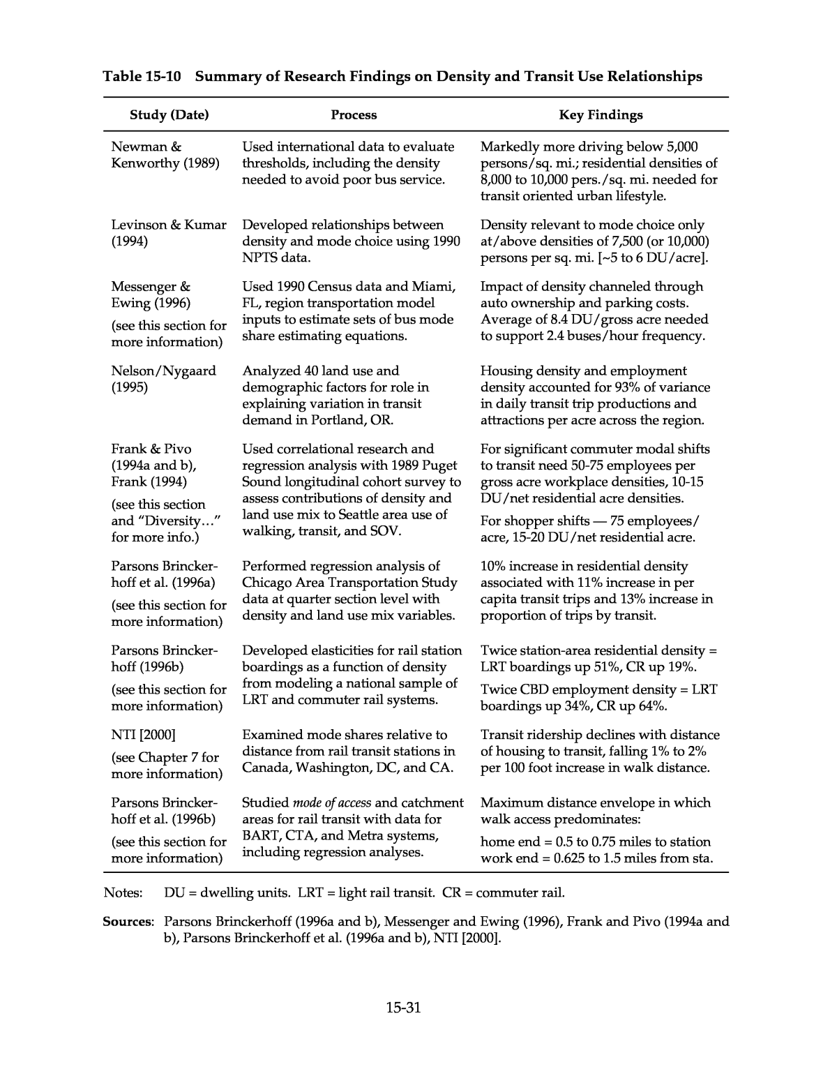
15-30 Density Rela ted to Transit Use The effectiveness of major investments in mass transit systems, or even various changes in transit service, depend critically on the ridership levels achieved by the service in relation to the amount of service provided and its capital and operating costs. Land use density has long been used as a major indicator of propensity for transit use and thus likely productivity in policy level assessments of transit service opportunities and practicality. Studies of the relationship of density to transit use may be divided into those focused mainly on development of transit policy guidelines, and research more oriented to delving into underlying relationships between density and transit use. Those studies that have developed full sets of density thresholds for different levels and types of transit service are encapsulated in Table 15-9. Table 15-9 Summary of Research Findings on Density Guidelines for Transit Service Study (Date) Process Key Findings Pushkarev & Zu- pan (1977 & 1982) Studied relationship between transit use and costs, and residential density and size of and distance from downtown, and developed density guidelines for different types and levels of transit service. Size of non-residential concentration most important, then distance from it, then residential density. Minimum residential density for basic local bus service is 4 dwelling units/acre. (See Table 15-48 for additional thresholds.) Institute of Transportation Engineers (1989) Advanced density guidelines for transit service. Minimum for hourly bus service is 4-6 DU/acre tributary to 5-8 million sq. ft. office/commercial (See Table 15-49.). NTI [2000] Assembled guidelines for transit friendly land use densities. Densities supportive of intermediate level bus service average 7 DU/acre and 20 employees/acre. Note: The Pushkarev and Zupan and Institute of Transportation Engineers key findings given here for context are illustrative examples only. For more comprehensive tabulations, explanations, caveats and discussion, see âRelated Information and Impactsâ â âTransit Service Feasibility Guidelinesâ â âDensity Thresholds for Transit Serviceâ (Tables 15-48 and 15-49). For example densities of cities and suburbs, and a brief discussion of density units of measure with conversion factors, see âExamples of Residential Densities,â the first subsection under âRelated Information and Impacts.â Sources: Cervero and Radisch (1995), Pushkarev and Zupan (1982), Parsons Brinckerhoff (1996a), NTI [2000]. The findings of the first listed studies in Table 15-9 (Pushkarev/Zupan and ITE) are, as indicated in the table note, more fully presented in the âRelated Information and Impactsâ section of this chapter under âTransit Service Feasibility Guidelinesâ â âDensity Thresholds for Transit Service.â Research concerned primarily with the density and travel demand interrelationships involved is covered here in this section, however, starting with the research summary in Table 15-10. Those studies listed in Table 15-10 that are expanded upon here in text, or elsewhere in this chapter, are so noted in the first column.
15-31 Table 15-10 Summary of Research Findings on Density and Transit Use Relationships Study (Date) Process Key Findings Newman & Kenworthy (1989) Used international data to evaluate thresholds, including the density needed to avoid poor bus service. Markedly more driving below 5,000 persons/sq. mi.; residential densities of 8,000 to 10,000 pers./sq. mi. needed for transit oriented urban lifestyle. Levinson & Kumar (1994) Developed relationships between density and mode choice using 1990 NPTS data. Density relevant to mode choice only at/above densities of 7,500 (or 10,000) persons per sq. mi. [~5 to 6 DU/acre]. Messenger & Ewing (1996) (see this section for more information) Used 1990 Census data and Miami, FL, region transportation model inputs to estimate sets of bus mode share estimating equations. Impact of density channeled through auto ownership and parking costs. Average of 8.4 DU/gross acre needed to support 2.4 buses/hour frequency. Nelson/Nygaard (1995) Analyzed 40 land use and demographic factors for role in explaining variation in transit demand in Portland, OR. Housing density and employment density accounted for 93% of variance in daily transit trip productions and attractions per acre across the region. Frank & Pivo (1994a and b), Frank (1994) (see this section and âDiversityâ¦â for more info.) Used correlational research and regression analysis with 1989 Puget Sound longitudinal cohort survey to assess contributions of density and land use mix to Seattle area use of walking, transit, and SOV. For significant commuter modal shifts to transit need 50-75 employees per gross acre workplace densities, 10-15 DU/net residential acre densities. For shopper shifts â 75 employees/ acre, 15-20 DU/net residential acre. Parsons Brincker- hoff et al. (1996a) (see this section for more information) Performed regression analysis of Chicago Area Transportation Study data at quarter section level with density and land use mix variables. 10% increase in residential density associated with 11% increase in per capita transit trips and 13% increase in proportion of trips by transit. Parsons Brincker- hoff (1996b) (see this section for more information) Developed elasticities for rail station boardings as a function of density from modeling a national sample of LRT and commuter rail systems. Twice station-area residential density = LRT boardings up 51%, CR up 19%. Twice CBD employment density = LRT boardings up 34%, CR up 64%. NTI [2000] (see Chapter 7 for more information) Examined mode shares relative to distance from rail transit stations in Canada, Washington, DC, and CA. Transit ridership declines with distance of housing to transit, falling 1% to 2% per 100 foot increase in walk distance. Parsons Brincker- hoff et al. (1996b) (see this section for more information) Studied mode of access and catchment areas for rail transit with data for BART, CTA, and Metra systems, including regression analyses. Maximum distance envelope in which walk access predominates: home end = 0.5 to 0.75 miles to station work end = 0.625 to 1.5 miles from sta. Notes: DU = dwelling units. LRT = light rail transit. CR = commuter rail. Sources: Parsons Brinckerhoff (1996a and b), Messenger and Ewing (1996), Frank and Pivo (1994a and b), Parsons Brinckerhoff et al. (1996a and b), NTI [2000].
15-32 Some of the research studies find higher densities required to sustain basic bus service than indicated by the guidelines identified in Table 15-9. This may reflect nothing more than confusion of basic bus service sustainability with having enough bus service to significantly affect mode choice, or a difference of opinion as to whether hourly bus service (as compared to half-hourly) is acceptable. The amount of transit ridership sufficient to justify a given level of transit service is in the end a local decision related to funding priorities, funding availability and other local policies related to farebox recovery ratios, transit coverage, and minimum frequency policy. Implications of transit service frequency are the subject of Chapter 9, âTransit Scheduling and Frequency.â Density and Transit Choice. Those studies that isolate the contribution of density to enhancing transit mode choice tend to confirm that the direct impact of density is slight if any, but that the indirect impacts â even without counting its contribution to feasibility of better transit service â are significant. Some of the limited research that has addressed the issue suggests that the total direct and indirect effects of density on transit use may be most important at the non-residential end of the potential transit trip. This observation pertains especially to those transit modes, particularly commuter rail, which rely heavily on auto mode of access (park-and-ride). On the other hand, it is at the residential end of the trip where the indirect auto ownership effects occur. The effect of density in contributing to sheer volume of riders cannot be overlooked. Even if transit mode shares did not change at all with increasing density, the same shares applied to a larger population would yield more riders. The volume effect of density is nicely illustrated by the âArlington County, Virginia, Transit Oriented Development Densitiesâ real world example under âCase Studies.â Arlingtonâs policy of focusing dense development on its Washington Metro stations is thought largely responsible for 1991 to 2000 ridership growth at the key Rosslyn, Court House, and Ballston stations of 121, 164, and 131 percent (more than a doubling in riders), respectively (Brosnan, 2000). A study based on conditions in Dade County (Miami), Florida, found overall density to be a significant determinant of journey-to-work bus mode share, operating indirectly through its influence on auto ownership and parking charges. The analysis employed 1990 Census travel data along with socio-economic, land use, and parking rate data developed for the regional transportation model, and corresponding transportation network characteristics. Using equations developed in the study, the authors ascertained that a density of 14,700 persons/sq. mile, or 8.4 dwellings per gross acre (at 2.75 persons per household), was necessary to support 25-minute average headways (time between buses) at the transit operatorâs minimum allowable productivity level, and 14.3 dwellings per gross acre at the systemwide average productivity level. Corresponding estimates of density required to support 15-minute bus headways were 11.1 dwellings per gross acre at the minimum allowable productivity level, and 19.4 for systemwide average productivity. It was noted that these thresholds could vary with incomes, parking costs, or other local conditions. Jobs-housing balance was found to be positively related to bus mode share by residence, but not by workplace. A balance of 1.5 jobs per household was estimated to produce a bus mode share 2 percentage points over that for a single use area (Messenger and Ewing, 1996). The authors judged the required minimum density to be above the âold industry standardâ of 7 dwelling units per acre, but taking service headway assumptions into account, the minimum allowable productivity level findings seem fairly consistent with standards presented under âRelated Information and Impactsâ â âTransit Service Feasibility Guidelinesâ â âDensity Thresholds for Transit Serviceâ (Tables 15-48 and 15-49).
15-33 Studies for the Washington State Transportation Commission tested relationships at the census tract level between urban form, including density, and travel behavior. The 1989 Puget Sound longitudinal cohort study survey provided travel data, while demographic and land use information came from local and Census sources. Densities were calculated on the total acreage of each census tract, giving average gross densities including all uses. Both correlation and regression analyses were used. The land use mix descriptors employed are presented in the âDiversity (Land Use Mix)â section, under âAccessibility, Entropy, and Other Measures.â Non-urban form variables, such as level of transit service and demographic factors, were also included. In general, significant relationships between travel behavior and urban form were found, even when controlling for non-urban form factors. In one of the few cases where the phenomenon has been reported, per capita person trip generation (all modes) for work trips was found to be elevated where population density, employment density, and mixing of land uses were greater. Work trip distance, however, was lower. No shopping trip generation relationship could be identified. Trip distances were again lower, however, where population density was higher. Overall, trip generation relationships were the least strong of any, while some of the strongest relationships pertained to mode choice. The study found population density to have a significant relationship with choice of the single occupant vehicle (SOV) and walking modes, while employment density appeared to have the strongest tie with mode choice overall. Among modes, choice of walking and transit (bus) was most influenced by density and land use mix, with use being highest where densities and land use mix were high. Although correlation with SOV use was not quite as strong, the relationship was consistently and significantly negative, with lower SOV use where density and mix were highest. Table 15-11 illustrates the sensitivities obtained in the regression analyses for mode choice as related to density. Shown are the estimated percentage modal shifts obtained with population densities increased by 10 persons per gross acre and employment densities increased by 10 employees per gross acre (Frank, 1994). Only the carpooling mode, not included within Table 15-11, exhibited weak relationships with urban form variables. Plots, made to examine non-linearity, showed carpooling to be most prevalent in moderately high density locations. However, no strong pattern was exhibited up to 13 to 18 persons per acre in the trip origin tracts, and about 75 employees per acre in destination areas, above which densities carpooling for both work commuting and shopping travel declined noticeably. These observations were taken to suggest that ridesharing may be more successful in suburban centers than in the downtown (Frank, 1994), which is where transit is more competitive. The most compelling finding in this analysis was the existence of significant and parallel shifts from SOV commuting to transit and walking above two distinct destination employee density thresholds. Significant shifts from SOV to transit and walking (from negligible to roughly 10 percent mode share each) were found to occur between 20 and 75 employees per gross acre and also (to around 20 percent walk mode share, and 20-percent-and-up bus mode share) at above 125 employees per acre (Frank, 1994; Frank and Pivo, 1994a and b). The existence of two separate thresholds (as compared to one) may or may not be an artifact of Puget Sound topology, demography, and transportation services, so that aspect of the findings should be considered with special caution by analysts working with other locales.
15-34 Table 15-11 Percentage Shifts in Mode in Response to a 10 Persons or Employees per Acre Density Increase â Estimated Based on Puget Sound Travel Data Percentage Change in Use Purpose of Trip Density Increase Type and Location Trip End Location Walk Transit SOV Work Population at Origin n/a â â -5.0% Population at Destination n/a +2.5% â â Population at O and D Origin +7.0%*(1) â â Population at O and D Destination â â -6.7% Employment at Origin Origin +1.7%*(1) â â Employment at O and D Origin â â, +1.7% â Employment at O and D Destination â +1.0, +6.5% -2.8% Shop Population at O and D Destination +8.9%*(2) â â Population at O and D Destination â +1.6*(3), +1.9% â Employment at Destination Destination +1.1%*(2) â â Employment at Destination Destination â â -1.9% Employment at O and D Destination â +0.5*(3), +7.6% â Note: âOâ stands for origin; âDâ stands for destination; ân/aâ indicates origin versus destination information not reported; âââ indicates parameter not reported and/or estimated. Where two sensitivities are listed, they come from different presentations in the source, and may represent results of alternative explanatory formulations. Some values are from the same equation (indicated with asterisks and corresponding equation numbers, for example, â*(1)â), suggesting the sensitivities involved are additive. Other values are or appear likely to be from separate equations, and may not be additive. Source: Frank (1994). Substantial shopping trip shifts from SOV and carpool to transit and walk were found to occur at destination densities above 50 to 75 employees per gross acre, and similarly at trip origin population densities above 13 to 18 residents per gross acre, with SOV shares dropping from roughly 55 to around 45 percent. For work trips, in terms of tract of origin population densities, choice of transit for commuting exhibited very moderate but steady increases with increasing densities throughout, more noticeable above 5 to 7 residents per gross acre, with shifts out of the SOV mode starting at the same point. Walking started to pick up above 7 to 9 residents per acre. From this residential end perspective, work trip transit share plateaued above 9 residents per acre at about 10 percent, while work trip walk share climbed on up to some 20 percent at 18 to 60 residents per gross acre (Frank, 1994). TCRP Project H-1 undertook analyses of density, land use mix, and urban design effects on both transit usage in general and rail transit ridership in particular. The land use mix and urban design results are reported here in the âSite Designâ section under âTransit Supportive Design and Travel Behavior.â Effects on overall transit usage were examined using Chicago Area Transportation Study (CATS) data, with their 1990 household travel survey, at quarter section level. Non-linear regression analysis produced the finding that a 10 percent higher residential density is associated with 11 percent more transit trips per capita and a 13 percent higher proportion of trips by transit. This and other Project H-1 analyses suggested that the
15-35 effect of density on transit riding is much stronger than the effect of land use mix or urban design (Parsons Brinckerhoff et al., 1996a). For light rail transit (LRT) and commuter rail (CR), TCRP Project H-1 estimated relationships between density and passenger boardings at individual stations using data on 19 light rail lines in 11 different regions and 47 commuter rail lines in 6 different regions. No other land use or demographic variables were included in these particular cross-sectional models except for the absolute number of CBD employees in the LRT model, and income in the CR model. Transit service variables other than mode identification were likewise not included (Parsons Brinckerhoff, 1996b). The sensitivities to density obtained with the models are summarized in the third from last row of Table 15-10. Given the model formulations, these sensitivities may be presumed to encompass a full range of direct, indirect, and surrogate effects of density. From these sensitivities the following arc elasticities may be calculated: +0.59 for LRT station boardings and +0.25 for CR station boardings relative to station area residential density (persons per acre), and +0.42 and +0.71, respectively, for station boardings relative to CBD employment density. The two models in question are more fully presented in the âRelated Information and Impactsâ sections of Chapter 7, âLight Rail Transit,â and Chapter 8, âCommuter Rail.â The modeled station boardings sensitivity to CBD employment density for LRT may be dampened, relative to CR, because of the inclusion of total CBD employment as another LRT boardings variable. Nevertheless, the higher CR ridership sensitivity to CBD employment density is thought to result in part from many commuter rail systems having only one downtown station to serve the entire CBD (Parsons Brinckerhoff, 1996b), and from the commuter rail service focus on peak period, CBD-oriented trips. The higher LRT boardings sensitivity to station area residential density, relative to CR, likely reflects the heightened importance of convenient access in the context of average LRT person trip length, typically much shorter than the very long trips characteristic of most CR riders. TCRP Project H-1 also examined relationships between density and station boardings using models based on one-city data. For Chicago, again, non-CR mode station boardings were more sensitive to residential density than CR boardings. Commuter rail boardings actually showed no sensitivity to residential densities in the analysis. Station boardings for heavy rail transit (HRT), the non-CR mode in this case, showed an elasticity of +0.37 relative to residential density. CBD employment densities could not be examined for importance using one-city data. Non-CBD commuter rail station boardings, and to a limited extent HRT boardings, were sensitive in a positive way to the presence of employment (Parsons Brinckerhoff et al., 1996a). This finding is discussed under âSite Designâ â âTransit Supportive Design and Travel Behavior.â Analysis of station activity on BART â the San Francisco Bayâs HRT system â indicated that both population and employment densities were associated with higher ridership levels, and also rates, such as weekday passengers per square mile of station catchment area (Parsons Brinckerhoff, 1996b). Quantitative comparison with the other station-level rail transit analyses is limited by the fact that CBD stations were included in the BART analysis. Several analyses, none of which took density into direct account, provide evidence that transit use declines with distance of housing from transit. Examples for bus transit are documented in Chapter 10, âBus Routing and Coverage,â under âUnderlying Traveler Response Factorsâ â âTransit Accessibility.â Analysis of data for several rail transit systems showed ridership
15-36 gradients that were fairly similar across systems in Washington, DC, California, and Canada. Ridership declined from 1 to 2 percent with every 100 foot increase in walk distance to stations, even though absolute values differed among cities. In the case of Washington, DC, as high as 63 percent of residents of housing near Metro stations have been observed to patronize rail to work. This has been interpreted as an example of âself-selectionâ of residence near rail stations for purposes of commuting (NTI, 2000). More information with regard to rail transit system usage is provided in Chapter 7, âLight Rail Transit,â and Chapter 8, âCommuter Rail.â To the extent that density gradients decline with distance from transit services and stations, the phenomena of highest ridership close-in can be part of the explanation for why higher densities are associated with higher rates of transit use. That explanation would have no relevance in the case of uniformly high densities. Density and Means of Transit Access. Density influences transit in two primary ways: First, as covered in the preceding discussion, overall density of the setting in which transit operates is a major factor in ridership attraction. Thus it is a crucial factor in whether the transit service can be provided with enough productivity to be both efficient and cost effective. Second, the density in the vicinity of transit stations and stops â at both origin and destination ends of potential trips â has major influence on the manner and ease with which patrons can get to and from the service. The density around transit stations reflects whether most riders can walk, bike, or take short bus rides to access the station, or whether it is necessary to travel longer distances by automobile or feeder bus for access. If the connection with transit is short and unimpeded, it reduces the time and cost associated with using transit, thus increasing the likelihood that it will be used. TCRP Project H-1 conducted a special study of mode of access and catchment areas for rail transit that analyzed the influence of distance, household and employment densities, and other variables on mode of access to rail stations in the Chicago and San Francisco areas. For San Franciscoâs BART, a heavy rail transit system extending far beyond the central cities, and Chicagoâs Metra, a commuter rail operation, many of the stations are suburban and are accessed principally by automobile. In contrast, Chicagoâs CTA heavy rail transit system contains few suburban stations or park-and-ride lots, and so access is mainly by transit or walking. The study analyzed observed data directly and also developed regression models describing mode of access for each rail system. High housing densities near stations clearly lead to high rates of walking as a station access mode. The highest rates (77 percent) were found at CTA North Shore stations where almost half the surrounding land use is in multi-family housing, with densities averaging 24 housing units per acre. Walk-on rates at highly urban City of San Francisco BART stations were 70 to 72 percent in the presence of 17 to 33 housing units per acre averages. Walk is the predominant mode of access for up to a half mile or more to rail stations. Table 15-12 summarizes the distances up to which walking dominates as a station access mode for each of the three rail systems studied. The table also indicates the mode of choice for distances too far to walk. It should be noted that Chicago commuters using Metra disembark at terminal stations that are not in the core central business district, and therefore require a longer walk to reach the same work places than CTA riders using âLoopâ elevated trains or downtown subways. It should also be noted that the number of people transferring
15-37 to another mode and not walking directly to their destinations at the work end of the trip is actually quite small (Parsons Brinckerhoff et al., 1996b). Table 15-12 Summary of the Influence of Distance on Modes of Access for the BART, Metra, and CTA Rail Systems Home End Work End System Distance up to which walking predominates Mode of access beyond walking distance Distance up to which walking predominates Mode of access beyond walking distance BART 0.625 miles Transit for shorter trips, park-and-ride for trips longer than 1 mile 0.625 miles Transit Metra 0.50 Drive, followed by being a passenger 1.50 Few trips beyond walking distance CTA 0.75 Transit 0.75 Transit Source: Parsons Brinckerhoff et al. (1996b). Transit was obviously found to be the main alternative to walking at the destination of a rail trip, as indicated in Table 15-12, with walking decreasing as the destination area became less urban. Walking predominates over longer distances for egress trips to workplaces, at least in the case of Chicagoâs Metra (Parsons Brinckerhoff et al., 1996b), and probably in other instances where the main rail terminal is somewhat removed from the core area. The prevalence of walking within the first half mile or so of a station strongly suggests that having higher proportions of residential development within that radius should lead to more people choosing to walk to transit, other things being equal. The mode of access models developed in TCRP Project H-1 for BART explicitly examined and confirmed this effect. Table 15-13 presents a set of sensitivity calculations, based on the mode of access and egress choice models developed in the TCRP Project H-1 research, that portray the importance of density in transit mode of access. The table gives the percentage point changes in the likelihood of a transit user on each of the three systems using a particular mode of access, expressed as percentage mode of access share, given a one unit increase in residential or employment density. The results suggest that either higher residential or employment densities will result in higher proportions of trips to rail stations made by walking, and reduced proportions by auto. Transit use for access is also reduced except in the case of Metra commuter rail. Residential density shows itself to be much more important than employment density in determining mode of access, and use of auto for access falls off much faster than transit use as density increases (Parsons Brinckerhoff et al., 1996b).
15-38 Table 15-13 Comparison of the Effects of an Increase in Densities on Mode of Access to BART, Metra, and CTA Rail Stations Percentage Point Change in Access Mode Share System Density Increase Walk Auto Transit BART One household/acre +1.7 -2.0 -0.7 One employee/acre +0.3 -0.9 -0.2 Metra One household/acre +2.2 -1.8 â One employee/acre â â +0.5 CTA One household/acre +0.8 -0.2 -1.1 One employee/acre +2.2 -0.4 -2.1 Source: Parsons Brinckerhoff et al. (1996b). Table 15-13 must be interpreted and applied with caution. Analyses for the different systems were shaped by major differences in types of data available and thus used different units of measurement, analytical techniques, and in some cases different variables. Most important, it should be understood that the BART modeling combined station access trips for both the home and the work end of travel, so the employment density results include density effects of the trip-makerâs workplace or other trip opportunity area. The Chicago (Metra and CTA) analyses addressed only the home end, and thus include only effects of employment density in the home-end station area. A variable explicitly measuring land use mix was included only in the BART model. That model showed mixed land uses to support more walking to BART (Parsons Brinckerhoff et al., 1996b). In the Chicago (Metra and CTA) models, since home area employment doesnât itself generate home to rail station travel, the fact that it has a positive influence on the choice to walk could be construed more as an indication of benefit accruing from land use mix than from density. Thus there is really some evidence from all three systems of a positive impact on the choice to walk of mixed land use. The TCRP Project H-1 research confirmed past assumptions about the maximum acceptable walking distance to rail transit stations of one-half to three-quarters of a mile, with the exception of egress from Metraâs downtown commuter rail terminals, not centrally located. It found the choice between bus and auto for station access beyond walking distances to be influenced toward bus use by lesser incomes, but not the decision to walk. In the case of BART, lower auto ownership (but not income) was associated with a higher probability of walking. The somewhat more detailed BART modeling indicated that walk trip lengths were longer in environments with higher densities and mixed land use, but evidence from Chicago contradicted this finding. The hypothesis that the walk access mode share of rail station patrons increases with levels of land use intensity and mixture was supported, as was the hypothesis that the auto share decreases, but not the supposition that the transit access share increases (Parsons Brinckerhoff et al., 1996b).
15-39 Diversity (Land Use Mix) Density, as the previous section illustrates, has historically been the central measure in studies of the relationship between land use and travel behavior. While important travel demand relationships with density are evident in the findings, diverse interpretations remain as to what extent density is really itself the factor causing the observed phenomena, as compared to merely standing in as a proxy for a variety of characteristics that describe different land use settings. One such characteristic is land use diversity or mix, which reflects the proximity of complementary activities to each other. The dominant post-World War II development patterns not only have stressed lower densities, but also separation of uses, the opposite of diversity. Understanding the effects of not only lower densities but also the separation of uses, independently and in combination, is crucial to efforts to dampen or reverse growth in trip distances and lighten reliance on auto travel. Land use mix research has ranged from using fairly simple measures of jobs/housing balance in attempts to explain commuting patterns, to applying complex measures such as âaccessibilityâ or âdiversityâ to reflect the convenience and relevance of different land use arrangements. Findings from key studies in each category are presented in this section, grouped under jobs/housing balance; accessibility, entropy, and other measures; and land use mix and transit use. While the main effect of jobs/housing balance is commute VMT reduction through trip distance reduction, effects of local area land use diversity/mix may well be most significant in encouragement of walking and carpooling, and to some extent use of transit, in part by freeing residents and workers from total reliance on private vehicles. Jobs/Housing Balance A gross measure of land use mix sometimes used by planners is the jobs/housing ratio, which describes the balance of jobs and housing. It serves as an indicator as to whether an area can supply job opportunities for all of its residents, or housing for all of its workers, or whether it absolutely must import or export workers in order to satisfy respective demands. The jobs/housing ratio is primarily an indicator for commute travel. An ideal jobs/housing balance for minimizing person miles of travel or VMT is yet to be fully specified. In both research and application, jobs/housing ratios have typically been defined in undifferentiated terms. Yet, to maximize potential for commute trip length reduction, jobs and housing would need to be matched by worker income level or job skills at the least. Also, since commonly used jobs/housing balance measures do not take into account income or skills, they cannot be used alone to address affordable housing issues. Projections of the proportion of commute trips that can be contained within a small area with ideal jobs/housing balance are often optimistic (Cervero, 1991a; Frank, 1994). In the real world, housing selections and job location decisions are made largely based on needs and preferences of individuals, or sometimes their employers, ensuring great variety in outcomes. Even if resident and workplace job skills are matched, jobs/housing balance only indicates potential for match-ups allowing internalized travel (Cervero, 1991a). It is unlikely that both jobs and housing needs will be satisfied internally for even the majority of dwellers or workers in a city sector or development community.
15-40 Key jobs/housing ratio studies are summarized in Table 15-14.6 Selected studies are expanded upon within this section, or elsewhere in this chapter, where and as noted in the table. Note that the percentage of internal commuting (intra-zonal, intra-district or intra-city) is inherently smaller for zones or sectors of a city than for a city as a whole, and that different means of reporting can also affect percentages (percent of residents working in an area versus percent of workers living in an area, with the latter giving smaller values for jobs-rich areas). Share of internal commutes is the measure that takes both residents and workers into account, and would tend to relate most closely with VMT generation. Trip Length/VMT Effects. Reduction in VMT through decrease in commuter trip length is the key apparent benefit offered by jobs/housing balance at a sub-regional scale, but the heavy reliance to date on analyses that have not moved beyond simple data tabulations suggests caution in application of findings, as will be discussed further shortly. In any case, it may be assumed that vehicle trip reduction, which would require mode shifts or substitutes for travel, is not as much affected by jobs/housing balance as VMT, which can be altered through trip length changes alone. The available quantitative study findings show a balance of jobs and housing to be associated with average commuter trip lengths lower by 7 to almost 30 percent, compared to where jobs and housing are out of balance. This can be seen with reference to Table 15-14 (Frank and Pivo, 1994b; Ewing, 1997; Cervero, 1996a, as presented in NTI, 2000). In the outlying example, in greater Seattle, 1989 commute trip lengths in Census tracts with adjusted jobs/housing balances lying between 0.8 and 1.2 were 29 percent shorter (6.9 miles average trip length) than in less well balanced tracts (9.6 miles average) â (Frank and Pivo, 1994b). Although trip length differentials found in San Diego and the San Francisco Bay Area are not as dramatic (Ewing, 1997; NTI, 2000), and other studies have found only extreme imbalance to have a notable effect (Giuliano, 1995; NTI, 2000), middle-of-the-road jobs/housing balance as a strategy for land development and redevelopment seems at first blush to offer not insubstantial traffic volume mitigation potential. The apparent strength of the jobs/housing balance descriptor must be tempered, however, with an appreciation of the context in which most available estimates have been derived. Much as in earlier phases of density research, jobs/housing balance has typically not been isolated from other characteristics with which it may frequently be associated, including density and centrality within the urban region. The effects of jobs/housing balance may well be found less in research taking associated transportation, land use, and socio-economic factors into full account. Indeed, a meta-analysis by Ewing and Cervero that employed a jobs/housing balance measure to represent local land use diversity produced modest partial elasticities, comparable in magnitude to those obtained for density when controlling for other built environment variables. (See last entry in Table 15-16, plus Table 15-56 and accompanying discussion under âRelated Information and Impactsâ â âTrip Making and VMTâ â âConsolidated Vehicle Trip and VMT Elasticities.â) 6 Table 15-14 and accompanying text contain references to adjusted jobs/housing ratios. In the first- listed study, for example, an âadjusted Jobs/Household ratioâ was computed by dividing jobs by households (HH) for each place, and then dividing the result by the mean number of jobs/HH in the whole metropolitan area (Frank and Pivo, 1994b). Adjusted jobs-housing balance measures used in other studies were computed using similar approaches. Unadjusted indicates a raw jobs/HH ratio.
15-41 Table 15-14 Summary of Research Findings on Jobs/Housing Balance and Work Commute Travel Behavior Study (Date) Process Key Findings Frank & Pivo (1994b), Frank (1994) Quantified relationship of jobs/ housing ratio to work trip length in Seattle area (see Tables 15-10, 15-16, for study this was an adjunct to). Average Trip Length = 6.9 miles if adj. Jobs/Household ratio = 0.8 to 1.2; 29% shorter than for less balanced ratios, where Avg. Trip Length = 9.6 miles. Giuliano (1995) (see this section for related Portland Metro study) Reported on 4 studies comparing actual metro area commute trip lengths to mean distance from the metropolitan center (25 U.S. metro areas, Boston, Baltimore, L.A.). Actual commute trip lengths averaged 11% longer in minutes (25 areas study) or 47 to 64% longer in miles (3 areas); âonly extreme imbalance has a notice- able effect on avg. commute lengthâ¦â San Diego Assn. of Governments (1991) as reported in Ewing (1997) Compared '90 Census commute trip lengths for zones w/excess housing, zones with J/H balance, and zones w/excess jobs, in San Diego area. Balanced zones had about 20% shorter trip lengths associated with them than zones w/excess housing, and about 16% shorter than zones w/excess jobs. Cervero (1996a) (see this section for more information) Assessed jobs/housing ratio changes and commute trip characteristics in 23 largest San Francisco Bay Area communities. Workers in jobs-rich cities averaged one-way commutes 11 percent more time consuming and with 7 percent more commute VMT per employee. Levine (1992) (see this section for more information) Examined correlations between income and commute distance using S.F. Bay Area travel data; modeled location decisions. Jobs-rich cities where multi-family housing has not kept up with growth exhibit longer commute trips for low income than for high income workers. Cervero (1991a) Reported mid-1980s data for two San Francisco Bay Area suburbs to show that J/H balance not always linked with internalized travel. Both cities had good jobs/housing ratios (1.3 to 1.5 unadjusted); 18% of Walnut Creek workers lived in town, 14% of Mountain View workers did so. Pivo, Hess and Thatte (1995) (see this section for more information) Examined 1970-90 density, jobs/ housing balance and travel trends/relationships in Washington State. Land use balance became more common, 1970â90; in balanced places and cities 20 to 60% of residents typically worked there (see Fig. 15-4). Ewing (1996) (see this section for more information) Related jobs/housing balance to work trip internal capture rate in 500 Florida cities, towns and places using 1990 U.S. Census. Share of internal commutes increases with better jobs/housing balance. Best new communities in U.S. estimated to achieve 31 to 37% internal commutes. Nowlan & Stewart (1991) (see this section for more information) Assessed role of large additions of central area housing in mitigating growth of inbound commute trips in the face of major downtown Toronto office construction. Over half of added downtown housing units were occupied by central area workers, allowing stabilization of congestion despite a doubling of office floor space. Sources: Frank and Pivo (1994b); Giuliano (1995); Ewing (1997); NTI [2000]; Levine (1992); Cervero (1991a); Pivo, Hess and Thatte (1995); Ewing (1996); Parsons Brinckerhoff (1996a).
15-42 Two studies with at least limited consideration of income factors, speculative-only in the first instance, are expanded upon here. Trends in jobs-housing balance and commuting patterns between 1980 and 1990 in the 23 largest San Francisco Bay Area cities received study by Cervero. A general trend toward balance and self-containment, as reflected in higher proportions of internal work trips, occurred during the period. This was ascribed to a maturation of commuter bedroom communities into mixed-use places, with jobs moving closer to labor pools. However, in jobs-rich cities, most notably in Silicon Valley, mismatches in jobs and housing became more skewed during the 1980âs. This was attributed mainly to zoning with exclusionary effects, limiting affordable housing options. Results are summarized in Table 15-15. Workers in high jobs-surplus cities averaged one-way commute times 11 percent longer, selected Drive Alone as their mode 5 percent more often, and produced commute VMT per employee 7 percent higher than in the other cities (NTI, 2000). Table 15-15 San Francisco Bay Area Commute Trip Characteristics Compared for Workers in High Jobs Surplus Cities and Other Cities Commuting Among Classes of Bay Area Communities Class of City Commute Time (minutes) Average Commute Drive Alone Share VMT per Worker High Jobs Surplus 26.5 78.3% 8.41 Other 23.8 74.3% 7.90 Source: Cervero (1996a) as presented in NTI [2000]. Another San Francisco Bay Area study suggests that the Silicon Valley jobs-rich cities it modeled in detail (Mountain View, Sunnyvale, Cupertino, and San Jose) had at least avoided a distortion of low-income worker travel patterns as skewed as found in one jobs-rich city across the Bay similarly modeled (San Ramon). In San Ramon, multi-family housing had not kept up with growth. The cities where multi-family housing development kept pace tended to have commuter travel patterns among their workers that were either largely independent of income, or exhibited longer trips on average by higher income workers, typical of monocentric development theory. In San Ramon, trips to work by lower income workers were longer than those by workers with higher incomes. The presence of two relocated firms in San Ramon may have had some effect on results (Levine, 1992). As was summarized in Table 15-14, an analysis by Giuliano concludes on the basis of four separate studies that âonly extreme imbalance has a noticeable effect on average commute lengthâ¦â (Giuliano, 1995). Research in Portland, Oregon, sponsored by Metro arrived at a similar conclusion. There it was found that high VMT per capita was associated with only extremely imbalanced neighborhoods, particularly those of outlying, job-poor, bedroom communities (NTI, 2000). Critics of using jobs/housing balance as a smart growth objective have noted that large center-city concentrations of employment, with implied accompaniment by jobs/housing imbalance in the commutershed, tend to be associated with lesser VMT. An example used is the case of New York versus Los Angeles. In Los Angeles, 96 percent of jobs are outside the CBD, deemed in the example to be balancing housing. In New York, 22 percent of jobs are located in Manhattan, leaving 78 percent for the commutershed, 19 percent less than in Los
15-43 Angeles. Yet, because of walking and transit use, New Yorkers generate 30 percent less in annual [per unit of measure] odometer mileage (OâToole, 2001). There are three points to be made here. First, 2000 Census statistics indicate that Manhattan also contains 16 percent of the population of the New York Primary Metropolitan Statistical Area (PMSA), so perhaps the New York versus Los Angeles jobs/housing balance is not really that much different at the gross total commutershed level used in the case example. Second, jobs/housing balance as employed in land use mix research and land planning applications is properly examined at or below a sub-regional scale (city sector, large suburb, or grouping of suburban communities). The objective is to identify, study, and address jobs/housing miss-matches at fine-grained enough levels of geography that effects of exclusionary zoning and segregation of land uses are identifiable. Third, building upon a valid perspective of the critics, it may well be inappropriate to expect that absolute theoretical balance is optimal, or to seek it as an overriding smart growth goal. More relevant may be avoidance of local area jobs/housing ratios at the extremes, or too far below the regional average as calculated for areas outside of CBDs and equivalent centers. Trip Containment Within Communities. Despite a tendency for over-optimism in some quarters concerning commute trip containment within communities, land use arrangements that facilitate trip containment do offer useful trip reduction potential. In examining trip containment data, which has been encountered only for work purpose travel, it is important to distinguish between information for large areas and that for small area subdivisions. Larger areas will, on average, inherently exhibit higher percentages of internal trips relative to smaller areas. A study for Washington State provides an example of analyzing trip containment on the basis of all sizes of areas ranging from the entire City of Seattle to Census-designated places of a few thousand persons. The unfortunately broad range of area sizes, imposed by the dataset selected, may be assumed to underlie some degree of the dispersion of data points encountered. In the majority of balanced cities and places of Washington urban counties, some 20 to 60 percent of residents worked in the same city/place. With cities such as the whole of Seattle included, the percentage reached 80 percent in some instances. Figure 15-4 provides a plot of the proportions of workers employed in their own Washington State city or place of residence, shown as a function of adjusted jobs/housing balance (Pivo, Hess and Thatte, 1995). In interpreting data displays like Figure 15-4, it is important to recognize that once adjusted jobs/housing balances exceed 1.0, the increasing percentages of residents working within their own community start to be overshadowed by increasing in-commuting from outside the community. This important phenomenon is not depicted in the figure, or in other similar data presentations encountered in the literature, thus only partially delineating the effects on VMT of lack of jobs/housing balance. An illustration of the phenomenon overall is provided by the San Diego area finding that in addition to balanced zones having about 20 percent shorter trip lengths than zones with excess housing, they also had about 16 percent shorter trip lengths than zones with excess jobs (San Diego Association of Governments, Regional Growth Management Strategy, Appendix 3, 1991, as bar charted in Ewing, 1997).
15-44 Figure 15-4 Percentage of residents who work in city/place of residence as a function of jobs/housing balance, Washington State Note: Once adjusted jobs/housing balances exceed 1.0, the increase in percentages of residents working within their own city/community (illustrated in the figure) starts to be overshadowed by the increase in percentages of workers in-commuting from outside the city/community (a phenomenon not illustrated in the figure). Source: Pivo, Hess and Thatte (1995). The Washington study also examined trends. Between 1970 and 1990, in urban counties, overall housing densities declined in all but the smallest Census-designated places. Average employment densities declined on the basis of averages weighted by employees, a weighting designed to reflect conditions encountered by the average employee. Employment densities did not decline when measured by averaging in the normal manner, weighted by land area.
15-45 In contrast to density, land use balance became more common over the period in the various districts of Central Puget Sound. To assess balance, an adjusted jobs-housing balance was computed by dividing jobs by households for each place, and then dividing that by the mean number of jobs per household in the whole metropolitan area. Retail-housing balances were computed in similar fashion. In the Puget Sound region, for example, the mean number of all jobs per household was 1.34 in 1990, and the mean for retail jobs per household was 0.24. The proportion of people living in jobs-housing balanced districts in Central Puget Sound rose from 8 percent in 1970 to 14 percent in 1980, but dropped to 13 percent in 1990. The proportion living in retail-housing balanced districts rose from just over 8 percent in 1970 to 11 percent in 1980 and 16 percent in 1990 (Pivo, Hess and Thatte, 1995). Journey-to-work data from the 1990 census for over 500 Florida communities were used to develop an estimating formula for the proportion of work trips that remain within a respective city or town. The share of internal commutes, identified as the âInternal Captureâ rate, was calculated with the following formula: Internal Capture = (2 x employed persons both living and working in the locality) ÷ (employed persons living in the locality + employed persons working in the locality) This formula allowed both residents and workers to be taken into account. Employed persons are multiplied by two to account for the fact that each employed person has two ends to his or her commute, one at home and one at the workplace. The calculated proportion ranges from 0 for no one living and working in the same community to 1 for everyone doing so. Job balance was also calculated in a manner designed to take both residents and workers into account. The job balance formula, which gives 0 in the case of no balance and 1 in the case of perfect balance, was: Regression analysis confirmed that the share of âinternalâ commute travel increased significantly with greater balance in number of local jobs and working residents. Zonal level aggregate measures of resident and worker wealth did not improve the estimating formula derived. The preferred formula was (Ewing, 1996): Internal Capture = 0.35 x (Internal Jobs)+0.21 x (External Jobs)-0.19 x (Job Balance)+0.28 A case example application using Miami Lakes, Florida, data illustrates the definition of the variables not specified above and the application of the formula. The community had 13,469 jobs out of 940,397 in the metropolitan region, thus Internal Jobs were 13,469 and External Jobs were 926,928. With 7,631 employed residents, the Job Balance formula gives a value of 1 â 0.28, or 0.72. Entering 13,469 and 926,928 and 0.72 into the Internal Capture formula above gives 0.17, or 17 percent for the internal share of commutes. The actual 1990 rate for Miami Lakes was 11 percent. The 6 percentage points overestimate relative to observed behavior was ascribed to a rise in Miami Lakes housing costs, relative to worker salaries, which created an economic mismatch of jobs and housing (Ewing, 1996). The formula is not sensitive to such conditions. â Job Balance = 1 â Absolute Value of (employed persons living in the locality employed persons working in the locality) ÷ (employed persons living in the locality + employed persons working in the locality)
15-46 The same Job Balance formula was applied to eleven ânewâ communities around the United States. The very highest internal capture rates thus estimated, employing 1990 Census data, were on the order of 31 to 37 percent. The three communities estimated to be in that range were Peachtree City, Georgia; Coral Springs, Florida; and Columbia, Maryland (Ewing, 1996). A study by Nowlan and Stewart of evolving land use patterns in Toronto concluded that despite substantial growth in downtown office space between 1975 and 1988, there was not a proportionate increase in commuting trips into the downtown. The possibility that increases in downtown housing supply were responsible was examined. It was found that over half the housing additions in the core were occupied by downtown workers, many of whom could walk, bicycle, or take short transit trips to work. Congestion levels had stabilized, despite a doubling of office floor space. This beneficial outcome was attributed to the large number of new housing units (Parsons Brinckerhoff, 1996a; NTI, 2000). Although this study didnât specifically address incomes, it serves by inference to further underscore the importance of housing matched to employee characteristics in jobs-rich areas. Accessibility, Entropy, and Other Measures Accessibility, entropy, dissimilarity and like measures are all focused on quantitatively describing different aspects of land use diversity or mix. Accessibility may have a strong regional as well as local component, and be influenced significantly by transportation facility and services placement. The other measures are very much focused on the local environment around oneâs residence and oneâs workplace, or other primary destination. Table 15-16 summarizes travel behavior research efforts designed to enhance understanding of land use diversity/mix effects. As in previous summary tables, the first column includes identification of those studies that are discussed further here or elsewhere in the text and of where the discussion is located. As alluded to previously, the line of demarcation between diversity (mix) and site designâs land use aspects is fuzzy. The research in both areas should be consulted to obtain a fuller array of pertinent findings. Density and Land Use Mix. Findings from studies of urban form and travel behavior done for the Washington State Transportation Commission were introduced in the âDensityâ section. These census tract level studies researched not only the impact of population density and employment density at origin and destination tracts, but also of land use mix. The underlying data on travel and urban form characteristics were obtained from greater Seattle local sources including the 1989 Puget Sound longitudinal cohort study survey. To provide a land use mix variable in support of the correlation and regression analyses employed, mix of uses was quantified using an Entropy Index measure. The measure was similar in concept to other such entropy measures used to describe land use variability and balance, but differed in form. It was applied at a tract rather than fine-grained level. This particular Entropy Index equation considered seven land uses: single family residential, multi-family residential, retail and services, office, entertainment, institutions, and industrial/manufacturing. It could produce a value between 0 and 0.845, where 0 represented homogeneous land use, and 0.845 represented a diverse mixture of development within a tract â equally distributed amongst the seven land uses. In application, the Entropy Indices of the various tracts ranged from 0.002 to 0.794, with a typical value of 0.47 (Frank, 1994).
15-47 Table 15-16 Summary of Research Findings on Accessibility, Entropy and Other Measures, and Travel Behavior Study (Date) Process Key Findings Frank & Pivo (1994a and b), Frank (1994) (see this section and âDensityâ for more information) Used correlation and regression analysis with 1989 Puget Sound data to assess effects of density and land use mix on trip lengths and choice of walking, transit and SOV. Person trip rates largely non-related to urban form; but trip length reduction positively related. SOV choice for work trips negatively correlated with land use mix; positive for bus, walk, and both work and shop carpool trips. Holtzclaw (1994) Developed model to explain auto ownership and household VMT in the San Francisco Bay Area, using density and transit accessibility. Model of auto ownership not enhanced by inclusion of land use mix (presence of neighborhood shopping), however, neighborhood shopping & pedestrian access strongly correlated to VMT. Handy (1993) Examined effects on person-travel for shopping (by non-central-city San Francisco Bay Area residents) of local (intra-zonal), and also regional, off-peak auto accessibility. No relationship between accessibility and number of shopping trips/person. Both accessibilities related negatively to trip length; 39% more travel for local/regional low/low vs. high/high. Ewing, DeAnna & Li (1996) Examined independent effects of land use variables on household trip rates for Dade and Palm Beach Counties, FL. (2nd order effects, e.g., through auto ownership, not tested.) Found no 1st order effects of significance for home zone accessibility, jobs/housing balance or density in modeling of total or vehicle trip generation rates. Cervero & Kockelman (1997) Estimated travel elasticities for 3 Ds (Density, Diversity/Mix of Uses, Design/Pedestrian Friendliness) in 50 contrasting San Francisco Bay Area neighborhoods using statistical models involving regression and logit analysis. Elasticities of non-auto (work purpose and non-work) travel with respect to: ⢠Greater density; ~0 work, +0.06 to +0.11 non-work. ⢠More diversity; +0.05 to +0.34 work, +0.11 to +0.14 non- work. ⢠Better design; +0.03 to +0.12 work, +0.08 to +0.18 non-work. Sun, Wilmot & Kasturi (1998) (see âDensity and Other Indicators..â for more) Analyzed Portland, OR, travel data using means tests and regression to explore relationships between household and land use factors, and amount of travel. Relationship of accessibility to jobs with trip making was contradictory, but negative correlation with VMT carried through as significant and logical in VMT regression equation. Kockelman (1996) (see this section and âUnderlying Traveler Response Factorsâ for more) Tested geographic information system (GIS)-based measures of land use intensity, balance and integration as improvement over density in explaining travel. Elasticities of household VMT with respect to intensity (accessibility), -0.31; land use balance (entropy), -0.10; integration (fine grained mix/dissimi- larity), -0.10 (See Table 15-18 for more). (Continued on Next Page)
15-48 Table 15-16 Summary of Research Findings on Accessibility, Entropy and Other Measures, and Travel Behavior, Continued Study (Date) Process Key Findings Steiner (1998) (see this section for more information) Utilized intercept survey and other data from 6 Oakland-Berkeley, CA, area traditional shopping districts to examine whether walk-accessible shopping brings reduced auto use. 20% to 38% of weekday shoppers (27% to 41% on Saturday) at the 5 most walk- accessible districts walked in. Higher levels of activity offset low auto shares to varying degrees. Ewing & Cervero (2001) (see also âOther Information and Impactsâ â âTrip Making & VMTâ â âConsolidated Vehicle Trip and VMT Elasticitiesâ) Went back to original sources, re-analyzing the data in selected cases, and developed âtypicalâ partial elasticities in a meta-analysis, controlling for other built environment variables. Local diversity (mix) is represented by a jobs/population balance measure; regional accessibility by a gravity- model-based index. Typical elasticities with respect to local diversity (mix) are: Vehicle Trips (VT): -0.03 Vehicle Miles Traveled (VMT): -0.05 Typical elasticity with respect to regional accessibility for VMT is -0.20 No significant sensitivity of vehicle trips to regional accessibility found. These elasticities âshould be additive.â Sources: Frank and Pivo (1994a and b); Parsons Brinckerhoff (1996a); Handy (1993); Ewing, DeAnna and Li (1996); NTI [2000]; Sun, Wilmot and Kasturi (1998); Kockelman (1996); Steiner (1998); Ewing and Cervero (2001). The strongest urban form relationships among those fully modeled pertained to mode choice. Analysis revealed that employment and population densities were positively correlated with transit and walk mode shares, and negatively correlated with the percentage of SOV trips. Except for carpooling, mix of uses was identified as significant for work trips but not shopping trips, with a positive correlation for transit and walk work purpose mode shares. Carpooling was significantly correlated only with land use mix, and positively so, for both work and shopping travel. The correlation analysis results are given in Table 15-17 (Frank and Pivo, 1994a; Frank, 1994). Multi-variate regression models were developed for all except work trip use of the carpool mode. One form of density or another was included in the preferred work trip and shopping trip models of SOV, transit, and walk mode shares. Sensitivities to density were presented in the âDensityâ section (Table 15-11). Land use mix was found useful as an independent variable in only the estimating equation for walk mode work trips. Sensitivity analysis using that equation indicated that an increase in the average mixing of uses at trip origins and destinations of 0.1 on the normalized Entropy Index scale would increase walking as a means of commuting to work by 2.0 percent as measured at trip origins, all else being equal (Frank, 1994). It should be noted that the combinations of density measures selected for most of the other estimating equations were to some extent proxies for mix, as when employment density at the origin (home) end of a trip was used.
15-49 Table 15-17 Correlation Between Urban Form Variables and Mode Choice Work Trips Mode Choice Variables (% Share) Employment Density Population Density Mixing of Uses SOV -0.26 â -0.13 Carpool â â 0.18 Transit 0.59 0.19 0.15 Walk 0.43 0.34 0.21 Shopping Trips SOV -0.15 â â Carpool â â 0.16 Transit 0.44 0.16 â Walk 0.24 0.31 â Sources: Frank and Pivo (1994a), Frank (1994). To summarize with respect to the full range of urban form measures employed in the correlation and regression analyses, the Washington State Transportation Commission research found that (Frank, 1994; Frank and Pivo, 1994a and b): ⢠The effects of urban form on trip generation (vehicle trips) are the least strong among those for any of the variables tested, although person trip generation for work trips inclusive of walking was found to be somewhat elevated where population density, employment density, and mixing of land uses were greater. ⢠Work trip distances are lower where population density, employment density, and mixing of land uses are greater. Shopping trip distances are lower where population density is higher. ⢠Higher densities are associated with lower proportions of travel by SOV, and are most strongly linked with higher use of the bus and walking modes. The relationships are non- linear â there are thresholds above which the more significant shifts occur. ⢠Greater mixing of land uses is correlated with lower SOV use and higher bus and walk mode choice for work trips, and with higher carpool use for both work and shop trips, but only in the case of choosing the walk mode for the work commute did the relationship prove statistically significant in the preferred research equations. For more on the first three points above, see âDensityâ â âDensity Related to Transit Useâ â âDensity and Transit Choiceâ earlier in this chapter. Washington Stateâs Puget Sound analysis found that a number of different combinations of higher population density, employment density and/or mixing and balancing of land uses will produce lower SOV use through shortening of trip distances and encouragement of walking and bus use (Frank and Pivo, 1994b).
15-50 Accessibility and Land Use Mix. Also introduced in the âDensityâ section, under âDensity and Other Indicators at the Behavioral Levelâ â âDensity as a Proxy,â was the 1996 thesis research by Kockelman. Her investigation of the influence of urban form on travel behavior was significant in moving beyond standard measures of density to integrated application of more functional measures of land useâs role in travel demand. Using San Francisco Bay Area data, the research also enhanced measurement through application of refined GIS techniques. The primary land use characteristics examined in addition to conventional developed area population and employment density measures were: ⢠Intensity, essentially a measure of accessibility to activity sites at a traffic analysis zone local/regional scale (expressed using gravity-model-derived formulations for importance and nearness of opportunities to satisfy typical needs such as working or shopping). ⢠Balance, including not just balance of jobs and housing, but a full array of land uses (expressed using a reformulated entropy index for quantifying uniformity of mixture â and departure from uniformity â in land uses at the neighborhood level). ⢠Integration, describing mix of adjacent land uses at the fine-grained level pertinent to description of walk trip opportunities and the like (expressed with a dissimilarity index that awarded points for each adjacent hectare developed with dissimilar land use). Each characteristic was represented through a separate index or indices, expressed as indicated. The actual formulae employed are given in the âUnderlying Traveler Response Factorsâ section under âDensity Versus Accessibility.â Using these indices, along with traditional density measures and various socio-demographic variables, models were developed to explain household VMT, non-work home-based (NWHB) household VMT, auto ownership, personal vehicle (PV) choice, and walk/bike choice. Elasticity results from the respective models are shown in Table 15-18 (Kockelman, 1996). Derivation and meaning of each of the variables is covered in more detail when this research is further expanded on in the âUnderlying Traveler Response Factorsâ section of this chapter. However, note that both auto ownership and income are household totals divided by the number of household members 5 years of age and older. General findings with respect to the land use index variables are as follows: ⢠Accessibility (the non-density intensity measure) proved to be the most influential urban form variable when viewed from the perspective of first order effects. Elasticities with respect to accessibility were in the range of -0.31 to -0.35 for VMT and personal vehicle choice, indicating auto use reduction in the presence of elevated accessibility, and +0.22 for walk/bike mode choice, indicating a positive effect. ⢠Entropy (land use balance) was also significant in predicting VMT and Walk/Bike choice. Elasticities with respect to the applicable entropy indices were -0.10 for household VMT, -0.30 for non-work VMT, and +0.23 for walk/bike choice, indicating auto use reduction and enhancement of non-motorized travel in the presence of good neighborhood land use balance. ⢠Dissimilarity (land use integration) was least influential of the three indices, but not insignificant for helping to explain VMT. Elasticities with respect to dissimilarity were -0.10 for total household VMT and -0.17 for non-work VMT, indicating further reduction with good land use integration at a fine-grained level. This added level of detail in
15-51 describing mix did not have significance in predicting mode choice, however, including walk/bike use. Table 15-18 Elasticity Estimates from Model Results, Kockelman Thesis a With respect to VMT per Household NWHB VMT/HH Auto Ownership PV Mode Choice a Walk/Bike Choice a Household size (age 5+) +0.82 +0.68 -0.23 â b â (Household size all ages) â1 â â â -0.067 c +0.48 c Income/member +0.16 +0.10 +0.10 -0.0021 +0.020 Auto ownership/member +0.56 +0.51 n/a +0.11 -0.60 Jobs density â â â negligible d â Population density â â -0.068 -0.013 â Accessibility e -0.31 -0.35 -0.075 -0.036 +0.22 Entropy (Balance) e -0.10 -0.30 -0.03 â +0.23 Dissimilarity -0.10 -0.17 -0.01 â â Notes: a Updated per Kockelman (1997). b âââ indicates variable not used. c Counterintuitive choice model signs on income are not unusual for the San Francisco Bay Area and may reflect the influence of a relatively high income, walkable, transit-rich center city. d The elasticity is negligible, but the variable is highly significant. e Formulation of index varies according to the travel parameter being estimated. Source: Kockelman (1996 and 1997). Although overshadowed in these research findings from the perspective of direct effects, density remained of interest for its indirect effects as channeled through auto ownership. This was detailed earlier in the introduction of Kockelmanâs work under âDensity.â Mix and Pedestrian Access. A quite different study in the Oakland-Berkeley, California, area used intercept surveys and other count, survey, and inventory data to assess whether a Main Street type of retail district located within a residential neighborhood and offering good pedestrian access would reduce auto use. The standards of comparison employed were the trip generation and parking demand guidelines of the Institute of Transportation Engineers (ITE) and Urban Land Institute (ULI), primarily based on 20th century post-World War II suburban shopping center designs. The six âtraditionalâ shopping districts examined were selected for characteristics that the New Urbanist movement was perceived to want in neo- traditional design. However, one site (El Cerrito Plaza) was separated from the neighborhood by a large parking lot. Each of the chosen residential areas was middle-class and possessed moderately high density (13 to 21 persons per gross acre), incomes at or slightly above the regional median, and variation in scale and mix of business activity. The study found that a significant percentage of customers at each of the shopping areas walked to their respective shopping district, as illustrated in Table 15-19. Weekday shares were 10 to 38 percent walk and 41 to 79 percent auto (driver or passenger), or 20 to 38 percent
15-52 walk omitting the El Cerrito site with its large intervening parking lot. Rates of walking were much higher among residents living within one mile of the shopping district: between 24 and 65 percent at all six shopping areas. Table 15-20 gives the distribution of shopper residence locations expressed in airline miles of distance from the shopping area. It illustrates a nearly even split, on average, between shoppers living within one mile and ânon-residentâ shoppers (Steiner, 1998). Table 15-19 Mode Shares for Shoppers at Six Oakland-Berkeley, California, Shopping Areas Selected for Traditional Layout and Generally Good Pedestrian Access Percentage of Respondents by Mode âTraditionalâ Shopping Area (store types) Weekday or Saturday Walk Bicycle Bus Rail Auto Rockridge-Market Hall Weekdays 26% 4% 11% 19% 41% (full array, restaurants) Saturdays 28 2 1 3 66 Rockridge-Alcatraz Weekdays 38 0 3 5 54 (grocery, specialty) Saturdays 41 3 3 1 52 Elmwood Weekdays 28 5 6 3 58 (convenience, specialty) Saturdays 36 4 1 2 57 El Cerrito Plaza Weekdays 10 5 3 2 78 (full array) Saturdays 10 2 2 1 85 Hopkins Weekdays 23 5 0 3 68 (specialty food) Saturdays 29 2 1 0 67 Kensington Weekdays 20 0 1 0 79 (convenience, services) Saturdays 27 1 0 0 71 All Areas Weekdays 24% 3% 4% 5% 64% Saturdays 28 2 1 1 67 Note: El Cerrito Plaza is separated from the neighborhood by a large parking lot. This shopping area was also experiencing poor sales. Source: Steiner (1998). Some difficulty was encountered in comparing ITE vehicle trip generation rates with the 3-1/2 to 6 hour survey data, and two methods were used. One method showed only the Rockridge-Market Hall shopping area to be exceeding ITE rates, and then only on Saturdays. The other method, conversion to average hourly rates, is the basis of the comparisons displayed in the first half of Table 15-21. They indicate that two out of the six shopping areas selected for traditional layout and good pedestrian access exhibited vehicle trip generation rates in excess of ITE standard values. The author concluded that although many customers walked, these shopping areas were characterized by a higher overall level of activity, causing the dampened local area auto use to be offset by auto-using shoppers from outside the neighborhood (Steiner, 1998).
15-53 Table 15-20 Percentage of Respondents by Distance of Residence from Six Oakland- Berkeley, California, âTraditionalâ Shopping Areas âResidentsâ âNon-Residentsâ âTraditionalâ Shopping Area Within 1/2 mile Between 1/2 & 1 mile Total Within 1 mile Between 1 & 5 miles More than 5 miles Total Beyond 1 mile Rockridge-Market Hall 24% 14% 37% 32% 31% 63% Rockridge-Alcatraz 40 21 62 25 13 38 Elmwood 33 18 51 29 20 49 El Cerrito Plaza 12 27 39 52 9 61 Hopkins 32 20 52 33 15 48 Kensington 58 18 76 19 5 24 All Areas 32% 20% 52% 32% 16% 48% Source: Steiner (1998) Table 15-21 Vehicle Trip Generation and Parking Rates for Six Oakland-Berkeley, California, Shopping Areas Compared to ITE Trip Rates and Two Parking Standards Average Hourly Vehicle Trip Ends Parking Used/Recommended Local Rates ITE-Based Rates Local Data Standard âTraditionalâ Shopping Area Week- days Satur- days Week- days Satur- days Week- days Satur- days New Ur- banist ULI Rockridge-Market Hall 6.42 12.71 6.41 6.06 263 357 195 261 Rockridge-Alcatraz 5.22 6.96 6.12 5.78 127 184 221 369 Elmwood 5.02 7.19 5.45 5.15 208 313 311 415 El Cerrito Plaza 1.46 1.76 3.43 3.02 182 286 1,301 1,917 Hopkins 8.55 14.82 8.31 7.85 77 139 90 120 Kensington 2.08 2.64 9.57 9.05 4 6 59 79 Notes: Vehicle trip end rates are expressed as vehicle trip ends per 1,000 square feet of retail space. Parking use and recommended parking figures are expressed as totals per shopping center. New Urbanist parking standards are per Calthorpe, P., The Next American Metropolis: Ecology, Community and the American Dream. Princeton Architectural Press, Princeton, NJ (1993). ULI parking standards are per Urban Land Institute, Parking Requirements for Shopping Centers: Summary Recommendations and Research Study Report. Washington, DC (1982). Source: Steiner (1998)
15-54 Parking generation was also compared with standard sources, as shown in the second half of Table 15-21. Here it was found that the parking demand at the highly successful Rockridge- Market Hall shopping area exceeded both what New Urbanist minimums (per Calthorpe) and ULI standards would suggest, on weekdays and Saturdays. Two other centers exceeded the suggested New Urbanist minimums on Saturdays. The author concluded that âreduced parking and transportation fees [for New Urbanist development] cannot be wholeheartedly supported if the needs of the neighborhood are to be consideredâ (Steiner, 1998). However, two observations not offered may be made with respect to parking: 1) The two locales identified as truly neighborhood shopping areas, Rockridge-Alcatraz and Kensington, could fit well under either parking standard. 2) Sharing of parking with office uses (in a new development context) could probably resolve the Saturday parking space requirement discrepancies highlighted (See Chapter 18, âParking Management and Supplyâ â âRelated Information and Impactsâ â âShared Parkingâ). Land Use Mix and Transit Use This subsection presents findings from research on the relationship between land use mix and mode choice, with a particular focus on transit use. A summary is presented in Table 15-22. Where additional information is provided in the accompanying text, or elsewhere in this chapter, the location is noted in the first column. The information is not restricted solely to transit impacts, and adds directly to the material presented in the preceding subsection. Mix and Mode Choice. The first four research project entries in Table 15-22 paint a picture of small but positive impact on transit choice of mixed land use, sometimes not possible to discern at all. The first listed study could not identify any discernable effect of land use mix on transit use, although it was associated with lower auto mode shares for midday access to major retail within suburban activity centers (Hooper, 1989). The next listed study did not find degree of mix a useful variable for its estimating equations, but did estimate that optimal jobs/housing balance â as compared to no mix at all â was associated with a 2 percentage point elevation in transit mode shares (Messenger and Ewing, 1996). The research listed third established positive correlations between land use mix and choice of transit, ridesharing and walking for the work commute, and ridesharing for shopping access. Only the relationship between mix and walking for the work commute, however, proved useful in estimating equations. A 0.1 increase in the land use mix index, on a scale from 0 to 0.845, was associated with 2.0 percent more walking to work as measured at trip origins (Frank and Pivo, 1994a; Frank, 1994). Finally, the fourth study listed determined that each 10 percent increase in commercial/retail space within a suburban employment center was associated with a 3 percentage point higher share of transit and ridesharing (Parsons Brinckerhoff, 1996a). Each of these research studies is expanded upon elsewhere as indicated in column one of Table 15-22.
15-55 Table 15-22 Summary of Research Findings on Land Use Mix and Transit Use Study (Date) Process Key Findings Hooper (1989) (see âSite Designâ section for more information) Surveyed travel characteristics of office workers, retail sites, residents, and hotels in 6 major U.S. suburban activity centers. Land use mix in centers reduces mid- day auto shares to major retail, at least. No definitive association between land use mix and transit use identified. Messenger & Ewing (1996) (see âDensityâ â âDensity Related to Transit Useâ for more information) Used 1990 Census data and Miami, FL, region transportation model inputs to estimate sets of bus mode share estimating equations, with testing of jobs-housing balance and degree of mix variables. Balance of 1.5 jobs per household estimated to produce a bus mode share 2 percentage points over the share for a single use area. Degree of mix not a useful estimating variable. Autos owned/density more significant. Frank & Pivo (1994a and b), Frank (1994) (See previous section including Table 15-17 for more information) Assessed effect of density and land use mix on mode choice for work and shopping trips in Puget Sound region, using an Entropy Index to quantify mix of uses. Greater mixing of uses only significant for work trips: positively correlated with carpool use for both work and shop; and for work purpose travel only, with choice of walk and transit modes; negative for SOV mode. In predictive equations, significant only for choice of walking to work. Cervero (1989) (See âSite Designâ â âSuburban Centersâ for more information) Analyzed travel patterns in relation to size and land use in 57 suburban activity centers. Centers with some on-site housing had 3 to 5% more transit, bike and walk commute trips. Transit and ridesharing up about 3 percentage points for every 10% more commercial/retail floor space. Parsons Brincker- hoff et al. (1996a), Cervero (1996b) (see this section for more information) Disaggregate analysis of travel behavior as related to land use mix, density and other variables in over 15,000 households of 11 large metro areas, surveyed by the 1985 American Housing Survey. Both higher residential densities and proximity of retail favor transit choice, but density most important. Proximity mainly important in choice of non-motorized modes, where shares may be 15 percentage points higher with retail close by. Parsons Brincker- hoff et al. (1996b) (see this section and âDensityâ â âDensity Related to Transit Useâ â â⦠Means of Transit Accessâ) Utilizing 1992 rider survey, modeled influence of land use mix around San Francisco area BART stations, along with other variables, on choice of access mode to rail transit stations. Mix strongly influenced choice of auto or walk access, with greater mix associated with less auto use and more walking, but not choice of transit for access. Elasticities for auto or walk access and egress in relation to mix more substantial than elasticities for density. Sources: Hooper (1989), Messenger and Ewing (1996), Frank and Pivo (1994a), Frank (1994), Parsons Brinckerhoff (1996a), NTI [2000], Parsons Brinckerhoff et al. (1996a and b).
15-56 The quantitative results obtained in those cases where the first four listed studies did identify land use mix effects are generally consistent with findings from a TCRP Project H-1 analysis of travel behavior of over 15,000 households surveyed in 11 metropolitan areas in the 1985 American Housing Survey. The findings suggest that both land use mix and residential densities are linked with mode choice decisions, as illustrated in Figures 15-5 and 15-6. The analysis revealed that close proximity of retail uses and residents was associated with non- automotive commuting in two ways â more walking and cycling for short trips and marginally greater transit travel. Only in the case of non-motorized travel, however, was presence of retail near residents as important as density (represented by different housing types). Design of the American Housing Survey was such that mixed land use was represented by existence of retail within 300 feet of the household. The set of models developed with the 11-city disaggregate data indicated that, in the case of one car households (for example), proximity of retail could add 1 to 2 percentage points to transit modal shares. In higher auto ownership, lower-density settings, however, the effect would be negligible. Figure 15-5 shows these relationships. The model set indicates a much higher importance for land use mix in the case of non-motorized travel â over short distances â as can be seen in Figure 15-6. Using the example of a one-mile commute from a one-auto household, there is a 17 percentage point addition to walk or bike trip choice if retail is in close proximity to housing in mid-to-high density settings, or 15 percentage points in low density settings. For commutes at any auto ownership or distance under 1.5 miles, neighborhood land use composition proved to be as important to walk and bike choice as density. The sensitivity of auto use to presence of retail was somewhat higher than transit use sensitivity, but substantially less than the walk/bike choice sensitivity. Again in the case of one-car households, a 5 percentage point dampening of auto choice was found with the presence of retail in mid-to high density neighborhoods. A 2 percentage point dampening was seen in low-density neighborhoods. No examination of auto occupancy effects was reported (Parsons Brinckerhoff et al., 1996a). It is not known how a definition of presence of retail looser than the 300 foot limit imposed by the data set would have affected findings. Mix and Means of Transit Access. Land use mix is of interest with respect to transit use not only for its potential effect on choice of primary mode, the concern of the immediately preceding discussion, but also for how it may influence mode of access to transit. TCRP Project H-1 investigated this subject insofar as rail transit access is concerned. Its findings were introduced and placed in context in the earlier section on âDensity,â under âDensity Related to Transit Useâ â âDensity and Means of Transit Access.â As noted there, a variable explicitly measuring land use mix was included only in access research models for the San Francisco Bay Areaâs BART heavy rail urban/suburban rapid transit. Midpoint elasticities of access/egress mode shares to various land use and other parameters were calculated from the BART mode of access models. Use of local transit for access to rail stations was found to be positively related primarily to transit service levels, secondarily to density, and not measurably to anything else. Choice of auto and walk access was, however, influenced by land use mix among other land use and design factors. The average of walk access and egress elasticities to an Entropy Index of mix within 1/2 mile of the station, where 0 (the lower end of the indexâs range) denotes a single land use and 1 (the upper end) denotes an even mix, was a very high +1.1. The auto access/egress elasticity to the mix index was -1.3. Walk and auto elasticities to density had the same signs, respectively, but were small in comparison (Parsons Brinckerhoff et al., 1996b).
15-57 Figure 15-5 Probability of commuting by transit as a function of auto ownership, for four land use scenarios Figure 15-6 Probability of commuting by walking or bicycling as a function of auto ownership, for four land use scenarios Note: Both Figures â Based on modeling of survey results from the 11 metropolitan areas (MSAs or CMSAs) of BostonâLawrenceâLowell, Dallas, Detroit, Los AngelesâLong Beach, Fort Worthâ Arlington, MinneapolisâSt. Paul, Philadelphia, Phoenix, San FranciscoâOakland, TampaâSt. Petersburg, and Washington, DC-MD-VA. Source: Both Figures â Parsons Brinckerhoff et al. (1996a).
15-58 These high walk choice elasticities reinforce the importance of land use mix to the use of non- motorized modes, indicating a strong positive relationship between walk access choice and presence of mixed land use, paired with a strong negative relationship between auto access choice and greater mix. The finding is sufficiently strong to withstand uncertainties introduced by the research model having been structured to estimate home-end and non- home-end access/egress jointly (in total).7 Moreover, as also discussed in the earlier section under âDensity,â the TCRP Project H-1 density impact findings for Chicagoâs commuter rail and heavy rail systems may be construed in part as an indication of positive impact accruing from land use mix on the choice to walk. Every indication is that the choice of walk versus auto access to transit is an aspect of travel behavior particularly sensitive to land use characteristics in general and mix in particular. Findings with respect to auto access are discussed further in Chapter 3, âPark and Ride/Pool.â Site Design The third aspect of land use believed to contribute to travel behavior is âdesign.â Site design attributes appear to affect travel choice and behavior in both commercial and residential settings. Design complements density and mix by addressing how those characteristics are arrayed and linked to one another. In and around a commercial setting, for example, a particular suburban activity center (SAC) might have significant intensity (density) and mix of development, but travel by means other than auto might be difficult or undesirable because of one or more of the following design features: ⢠Large blocks and poorly linked, insufficient sidewalks/walkways (lengthening pedestrian routings). ⢠Lack of pedestrian and bus patron buffering from vehicle traffic (narrow sidewalks at the curb, next to fast traffic lanes). ⢠Expansive arterials/intersections with infrequent opportunities for safe and comfortable pedestrian and bus patron crossing. ⢠Non-connecting and indirect street patterns, diminishing feasible bus service levels. ⢠Large building setbacks from streets, with separation by and orientation to parking lots, making access on foot or by transit difficult or inconvenient. Considerable recent research has been focused on the issue of design, perhaps the most âqualitativeâ link between land use and travel behavior. Studies at different scales (macro versus micro) have investigated whether design characteristics of various settings may be linked with differences in travel. Late 1980s studies sponsored by the National Cooperative Highway Research Program (NCHRP) and the Urban Mass Transit Administration (UMTA, now FTA â The Federal Transit Administration) first called attention to the auto-oriented design and travel 7 Joint modeling of home-end and non-home-end mode of access/egress â sometimes necessary depending on data availability â is an approach clouded by auto availability at the home end of a transit trip seldom being matched by auto availability at the non-home end (since transit riders leave their car behind), making the home-end and non-home-end choice sets typically different.
15-59 characteristics of suburban employment centers, the setting for the late 20th Century mass movement of jobs to suburban areas. Other research has looked at the value of traditional transportation networks with grids and small blocks in contributing to shaping mode choice, trip length, VMT, and travel speed. Perhaps the greatest interest â and controversy â has centered on the design aspects of traditional neighborhoods and towns, and whether the design characteristics of such places yield sufficiently different travel behaviors to support their adoption as transportation or growth management tools. This section presents research findings from each of these areas of study, and closes with Transit Supportive Design. Suburban Centers Key findings for suburban centers and worksites have been summarized in Table 15-23. Parenthetical entries in the first column indicate the availability of additional information in the accompanying text. When making use of the information in this subsection, note that the line of demarcation between the land use mix aspects of âSite Design,â and land use mix as covered in the previous subsection under âDiversity,â is not at all precise. While a SAC addressed under site design will be smaller than a metropolitan region and many cities (but not all), it may be the same size as an urban âdistrictâ covered under âDiversity,â and will typically be substantially larger than a âtractâ or âzone,â also covered under âDiversity.â One aspect of land use mix specifically covered under âSite Designâ is the provision of supportive uses at a fine grained scale, such as specific services to support office uses. The âDiversity (Land Use Mix)â and âSite Designâ sections of this chapter must both be consulted for the full array of land use mix findings. Suburban Activity Centers. The NCHRP Report 323 examination led by Hooper of âTravel Characteristics at Large-Scale Suburban Activity Centersâ was one of the major late 1980s studies of suburban mega-developments. Large-scale SACs were defined for this study as having greater than 5 million square feet of office and retail space. Findings were derived on the basis of surveys of employees at 60 office buildings, intercept surveys at 24 retail sites and 15 hotels, and trip diaries distributed at 18 residential complexes. Table 15-24 identifies the six SACs studied, describes their employment size, density, and office/retail mix, and gives office employee travel characteristics. Table 15-25 provides midday mode shares from the surveys at the seven super-regional retail centers in the six SACs, along with context. While densities at five of the sites range from 25.9 to 30.6 employees per acre, Bellevue stands out with 43.2 employees per acre, and also features a much more pedestrian and transit- friendly design. The five lower-density sites had office worker drive-alone commute shares that averaged 92 percent, compared to 73 percent for Bellevue. Correspondingly, commute shares for alternative modes were consistently higher in Bellevue, as can be seen by comparing the first and last rows of Table 15-24. The author noted the successful association of Bellevue with its transit center, and recommended that suburban centers could improve their relationship with transit by becoming transfer stations (Hooper, 1989). It should also be pointed out that Bellevue is known for having several successful Travel Demand Management (TDM) programs, undergirded by a deliberately tight parking supply and accompanying parking pricing. (See the case studies covering individual worksites and Bellevue as a whole in Chapter 13, âParking Pricing and Feesâ; Chapter 18, âParking Management and Supplyâ; and Chapter 19, âEmployer and Institutional TDM Strategies.â) These factors assuredly play a major role in determining Bellevueâs travel characteristics.
15-60 Table 15-23 Summary of Research Findings on Site Design of Suburban Activity Centers and Travel Behavior Study (Date) Process Key Findings Hooper (1989) (see this section for more information) Surveyed and analyzed travel characteristics at six large scale (greater than 5 million square feet office/retail) suburban activity centers utilizing counts, office employee surveys, retail and hotel intercept surveys, and housing resident trip diaries. Land use and transportation design of Bellevue, WA, site produced very different travel characteristics than other sites (Bellevue vs. others): 73% vs. 92% SOV office commute 17% vs. 7% auto passenger commute 9% vs. 0.5% transit commute 1% vs. 0.3% bike/walk commute Cervero (1991b) (see this section for more information) Conducted follow-up studies of the influence of site design aspects of suburban activity centers, utilizing detailed data from the six âedge citiesâ surveyed in Hooper (1989). Employee vehicle trip rates more sensitive to parking supply (elasticity = +0.20) than land use mix (-0.06). Transit use more sensitive to mix (elasticity = +0.27) than parking (-0.10). In-building retail and size of building related negatively to office employee vehicle trip generation and positively to transit use and ridesharing. Cervero (1988 and 1989) (see this section for more information) Conducted multi-part surveys, reconnaissance, and data gathering of land use and transportation characteristics of 57 large suburban employment centers and clusters, and used results in aggregate-level, national scale statistical tabulations, hypothesis tests, and causal models. 83% of suburban employment center (SEC) workers drove alone, but share of commute trips in non-SOV modes (ridesharing included) was higher with greater density/mix. Most use of alternative modes in Sub- Cities and large MXDs, where land use mix/density in combination are highest, nevertheless, these SEC types also have the most congestion. Comsis (1994) (see this section for more information) Investigated importance of nearby commercial/retail services (within 5 minute walk of workplace) in the effectiveness of 49 employer TDM programs. TDM programs at sites with no, poor, or fair availability of services averaged vehicle trip rates 7.4 percent lower than ambient, vs. 21.5 percent lower for sites with good availability. Cambridge Systematics (1994) (see this section for more information) Explored connection between work environment and workersâ travel behavior at 330 Los Angeles region employers with TDM programs. Land use mix associated with 1.9 to 3.5 percentage point elevation in transit use for commuting (53% higher for TDM programs with no financial incentives, and 121% higher for programs with financial incentives, respectively). Sources: Cervero (1988), NTI [2000], Parsons Brinckerhoff (1996a), Comsis (1994).
15-61 Table 15-24 Employment and Office Commute Mode Characteristics at Six Large-Scale Suburban Activity Centers Employees (thousands) Office Employee Commute Mode Suburban Activity Center Office Retail Total Employees per Gross Acre a Drive Alone Auto Pass. Bus Bike Walk Bellevue, WA (Seattle region) 12.9 6.2 19.0 43.2 73.2% 16.9% 8.8% 0.3% 0.8% South Coast Metro (So. California) 10.5 6.9 17.3 29.9 92.5% 6.4% 0.1% 0.2% 0.8% Parkway Center (Dallas) 35.0 13.4 48.4 25.9 94.2% 5.6% 0.2% 0% 0% Perimeter Center (Atlanta) 39.0 3.4 42.4 29.3 93.0% 6.5% 0.5% 0% 0% Tysonâs Corner (No. Virginia) 32.5 5.2 37.6 30.6 89.2% 9.8% 0.7% 0.1% 0.2% Southdale (Minneapolis) 13.7 6.2 19.9 20.7 92.1% 6.6% 0.8% 0.2% 0.3% Average without Bellevue 92.2% 7.0% 0.5% 0.1% 0.2% Note: a Including SAC land not yet developed. Source: Hooper (1989). Table 15-25 Midday Non-Auto Mode Shares at Super-Regional Retail Centers Within Six Large-Scale Suburban Activity Centers Midday Mode Share Suburban Activity Center Super-Regional Retail Center Transit Walk Office Within Short Walk a Bellevue, WA (Seattle region) Bellevue Square 5% 6% 2.1 million GSF South Coast Metro (So. Calif.) South Coast Plaza 0% 4% 1.6 Parkway Center (Dallas) Galleria 1% 17% 2.1 Parkway Center (Dallas) Prestonwood Town Ctr. 0% 2% 0.7 Perimeter Center (Atlanta) Perimeter Mall 0% 7% 2.8 Tysonâs Corner (No. Virginia) Tysons Corner 0% 4% 1.5 Southdale (Minneapolis) Southdale Mall 1% 5% 0.7 Note: a Millions of gross square feet (GSF) of office space within 2,000 ft. walking distance of the super-regional retail center, not across a limited access highway. Source: Hooper (1989).
15-62 Bellevue also exhibited higher mid-day office-worker use of non-auto modes, with about 1/4 of midday office-worker trips in Bellevue made by walking. An average of 6 percent of such trips were made on foot at the other five SACs. Turning to Table 15-25 for retail patron shares indicates that non-auto shares for midday arrival at the seven super-regional retail centers contained within the six SACs sometimes differ sharply from those for the SAC office workers. Higher retail center walk mode shares appear to be somewhat related to the amount of office development within âwalking distanceâ (2,000 feet without crossing a limited access highway). The notable 17 percent walk mode share at the Galleria mall in Parkway Center was attributed to its location as part of a mixed-use sub-complex within the overall SAC (Hooper, 1989). As covered further on, SACs in Houston (Cervero, 1988) exhibit overall walk trip mode shares of close to the same magnitude as cited here for Bellevue office worker midday trips, but the data is not exactly comparable. About 1/2 of all office workers in the various SACs studied left their building in the midday, with the proportion of all office workers making midday trips internal to their SAC ranging from 20 percent of employees at Parkway Center to 33 percent at Perimeter Center. No clear relationship was identified between the percentage of office workers taking internal trips and aggregate land use and site design characteristics among the six SACs. The distribution of restaurants in and around the SAC was, however, observed to affect midday travel patterns. Lack of free-standing fast-food restaurants in Perimeter Center, and the SACâs relative isolation from other non-residential use, led to a high proportion of midday travel to the Perimeter Mall food court. Only Bellevue exhibited substantive transit use for access to its retail mall. For trips by all modes to and from the regional malls, the proportion internal to the SAC was found to be related to SAC size. In the larger SACs (Parkway Center, Perimeter Center, Tysons Corner), 1/2 of midday trips and 1/3 of evening peak-period trips were internal. In the smaller SACs (Bellevue, South Coast Metro, Southdale), 1/4 of midday trips and 1/7 of evening peak- period trips were internal. For hotels, over 1/3 of morning and evening peak period trips were internal to the larger SACs, while proportions for the smaller SACs were 19 percent AM and 27 percent PM. Of employed residents, 33 percent in the larger SACs and 27 percent in the smaller SACs reported their place of employment to be within the SAC. Not all SAC dwelling units sheltered an employed person; retirees were often encountered (Hooper, 1989). In a follow-up study of six edge cities (the same SACs as in Hooper, 1989), the following findings were derived at the building level concerning the influence of SEC site design on travel behavior (NTI, 2000): ⢠Trip generation rates: Existence of retail in office buildings was associated with vehicle trip rates lower by 6 (also reported as 8) percent. ⢠Modal Split: â Commute trip transit shares were 3 percent higher in office buildings with a mixed- use retail component than in office-only buildings. â Density was related to transit use: 10-story buildings exhibited 4 percent more transit use than 1-story buildings. â Mixed use showed a small but positive effect on incidence of walking trips.
15-63 ⢠Vehicle Occupancy: Scale, level of mixing, and parking supply were found to affect ridesharing. â A 1 million square foot building, for example, averaged 0.8 more passengers per work trip than a building half that size. â Parking supplies less by half were associated with 0.5 more auto passengers per trip. Overall, size, density, and tenancy were found to be more influential than land use mix as determinants of travel behavior. Not investigated was the possibility that larger buildings may tend to house larger employers, who in turn may offer more support for alternative (non-SOV) commute modes. Of particular note was the finding that, in terms of vehicle trip rates, workers were more sensitive to the supply of parking than land use mixture. On the other hand, transit use for commuting showed more sensitivity to presence of mixed uses. These relationships are shown as elasticities in Table 15-26 (NTI, 2000). Table 15-26 Elasticities of Travel Demand with Respect to Land Use Mix and Parking Supply for Six U.S. Edge Cities Mode Share of Commute Trips Automobile Transit Vehicle Trips per Employee Mixed Use Measures -0.02 +0.27 -0.06 Parking Supply +0.07 -0.10 +0.20 Note: Locations same as those studied in Hooper (1989); see Table 15-24 for SAC descriptions. Source: Cervero (1991b) as presented in NTI [2000]. Suburban Employment Centers. The first of the late 1980s landmark studies of the land use- transportation link and mega-developments, led by Cervero for UMTA, focused specifically on SECs. SECs were defined as centers with at least 2,000 workers and 1 million square feet of office space. The study compiled and examined land use and transportation data for 57 of the largest SECs in the United States, selected from 26 of the largest metropolitan areas. Six different classes of SEC were defined, utilizing cluster analysis (Cervero, 1988): 1. Office Parks: Campus settings devoted to office development, usually absent of housing, commercial, or most retail activities, with low-density building profiles, abundant parking, and park-like landscaping. 2. Office Centers and Concentrations: Similar to Office Parks, but larger, denser, and typically less controlled, but still with limited on-site retail or commercial activities. 3. Large Mixed-Use Developments (MXDs): Distinguished by a mixture of land uses and much more of a balance of office, commercial (usually including a regional mall), light industrial activities, and housing (generally several thousand units); at least 1/3 non- office, and covering a fairly large territory (at least 3 square miles).
15-64 4. Moderate-Size MXDs: Resembling large MXDs, but with far less acreage â typically less dense but a well-defined, architecturally-integrated core. 5. Sub-Cities: Also known as âedge cities,â located on the fringe of large cities, smaller than large MXDs but downtown-like in density and land use mixture â predominately office, but retaining suburban-like qualities. 6. Large-Scale Office Growth Corridors: Largest scale SEC (some over 80 square miles) and least like other SECs, resembling more of a swath of ad hoc office, commercial, and mixed urban development, with tremendous cumulative effect, typically along a major highway corridor. The physical and land use characteristics of these different types of SECs followed by the associated commuter travel (work trip) characteristics are summarized in Table 15-27 (Cervero, 1988). Statistical comparison of differences in the characteristics of work trips among the six classes of SECs, including some relationships quantified shortly after the original project, produced the following conclusions (Cervero, 1988; Parsons Brinckerhoff, 1996a): ⢠The site variables that most influenced employee travel behavior and local traffic conditions were density, size, and land use mix. Share of commute trips made in non- SOV modes increased as SECs became more dense and encompassed a wider variety of land uses. Follow-on analyses estimated that every 10 percent addition in floor space for retail or commercial uses was associated with a 3 percentage point elevation in the share of transit, rideshare, and non-motorized commutes. ⢠Driving alone accounted for over 4 out of 5 commute trips for the entire SEC sample, 83 percent to be exact, significantly above SOV shares for the regions as a whole. Large MXDs and Sub-Cities had the lowest level of SOV commuting to SECs â 80.0 and 80.6 percent, respectively. These SOV shares were closer to those of the region (only 6.4 to 6.8 percent higher) than for the other SEC types (9.1 to 13.0 percent higher). ⢠On average, 13 percent of SEC workers commuted by ridesharing (vanpool or carpool), closely matching 1980 U.S. national averages. Ridesharing was highest in settings with substantial commercial/retail components and the higher densities, most notably in Sub- Cities and MXDs. ⢠Use of transit for commuting was very limited at most SECs, averaging about 2 percent. Only four areas (Bellevue, Washington; Bishop Ranch and Hacienda Business Park in California; and Meadowlands, New Jersey) had transit shares of or greater than 7 percent, the 1980 national average for metropolitan areas. Bellevueâs success was attributed to its containment of parking, its transit center serving as transfer point for 17 bus routes, and to its exhibiting more of a downtown character (sidewalks, reduced building setbacks) than other SECs.
15-65 Table 15-27 Suburban Employment Center Land Use and Commute Characteristics Land Use Characteristic a (density/mix/design) Office Parks Office Centers Large MXDs Medium MXDs Sub- Cities Large Corridors Number of Sites Studied 10 8 14 8 10 7 Acreage (thousands) 0.25 - 1.0 0.25 - 2.8 2.6 - 19.7 0.35 - 0.86 0.33 - 2.24 30.0-300.0 Employment (thousands) 4.1 - 11.9 6.0 - 20.3 5.0 - 53.0 2.2 - 15.3 16.0 - 59.5 39.0-480.0 Floorspace (millions of square feet) 1.7 - 4.3 2.0 - 10.8 3.6 - 29.0 1.3 - 7.1 6.5 - 25.3 11.0 - 31.5 Floor Area Ratios (FAR) 0.24 - 0.42 0.30 - 2.70 0.50 - 1.30 0.33 - 0.92 0.85 - 3.10 0.20 - 0.60 Retail centers (Number) 0 - 1 0 - 2 1 - 20 1 - 4 2 - 8 n/a On-site Dwelling Units 0 - 100 0 - 380 0 - 9,000 0 - 500 200 - 5,600 n/a Percent office space 65 - 99% 85 - 99% 16 - 66% 30 - 60% 50 - 70% 52 - 74% Percent commercial space 1 - 10% 2 - 10% 8 - 25% 10 - 30% 12 - 34% 8 - 20% Land use mix Entropy b 0.25 - 0.35 0.22 - 0.35 0.45 - 0.58 0.47 - 0.56 0.41 - 0.51 0.37 - 0.50 Parking spaces per 1000 square feet 4.0 - 5.0 3.3 - 4.0 3.3 - 5.0 4.0 - 4.6 3.0 - 4.0 3.5 - 4.5 Commute Characteristic c Most frequently occurring daily parking price d $0.00 $1.17 $0.73 $0.00 $1.08 n/a SOV mode share 85.5% 86.6% 80.0% 86.3% 80.6% 84.2% Vanpool mode share 3.4 2.1 3.6 2.0 2.6 1.2 Carpool mode share e 8.5 8.8 12.0 9.0 11.3 11.6 Walk mode share 0.3 0.5 1.2 0.5 1.4 n/a Transit mode share f 2.3 2.0 3.2 2.2 4.1 3.0 g SOV share differential h 9.1 13.0 6.4 10.9 6.8 n/a Percent employees with âstaggeredâ hours 38.0% 26.1% 21.3% 17.9% 21.8% n/a Most common arrival and departure times 8:10 AM 4:49 PM 8:10 AM 4:57 PM 8:25 AM 4:58 PM 8:26 AM 5:00 PM 8:05 AM 5:01 PM 8:17 AM 4:55 PM Notes: a Land Use Characteristic ranges are from next-to-lowest to next-to-highest values. b The âoriginalâ Cervero âEntropy Indexâ â ranges from 0 (least mix) to 0.60 (most mix). c Commuter Characteristics are shown as group means except for prices and times. d A majority of workers receive employer subsidy to cover all or most of any parking fee. e Not reported by source study; determined by subtracting vanpool from rideshare. f Not reported by source study; determined by subtracting other modes from 100%. g Large Corridor âTransitâ share value presumably includes âWalkâ mode. h Percentage SOV share in excess of the regional percentage (percentage points). Source: Cervero (1988).
15-66 ⢠The share of work trips made by walking averaged on the order of 1 percent overall, compared to 4 percent nationally. It was highest in Sub-Cities (1.4 percent) and large MXDs (1.2 percent). These SEC types had the most multi-family housing units within a 3-mile radius, suggesting that availability of moderately-priced housing induced some employees to reside nearby and walk to work. ⢠Walk trips in SECs were more common for non-work trips, depending on mix and proximity of other land uses, and pedestrian access. Walk trips comprise 32 percent of mid-day travel along Bellevueâs main pedestrian spine. Overall data for Houstonâs SECs show 20 percent of all trips were made by walking in 1987, 1/3 of them between 11:00 AM and 2:00 PM. Non-work trips were 22 percent walk. Pedestrians in Houstonâs SECs faced disconnected sidewalks, long block faces, and limited crossings. ⢠Sub-Cities displayed the lowest degree of commute trip peaking among SECs, likely in response to the highly varied land uses, which produce correspondingly varied commute trip arrival and departure times. Many SECs feature high midday peaks, as employees drive to lunch and errands. ⢠The two SEC groups with the highest street and freeway traffic volume to capacity ratios were Sub-Cities and Large MXDs (not counting Large Corridors, which were not included in the traffic flow evaluation). Thus the two SEC categories that exhibited the lowest SOV shares still had, because of their high densities, the most congestion. This finding highlights the trade-off between better accommodating the auto and encouragement of alternative modes. Sub-Cities and Large MXDs, as constituted, had not reached a point of sufficient viability for ridesharing and mass transit. Worksites with TDM. TCRP Project B-4, in a study of 49 employer TDM programs, examined employee vehicle trip generation rates in relation to both TDM program elements and site characteristics. Site commute vehicle trip rates were compared with ambient rates for the surrounding area to gauge the vehicle trip reduction effectiveness of the employer programs. A key site characteristics measure was number of nearby commercial/retail services â restaurants, shopping, banking, etc. â within a 5 minute walk of the workplace. Sites were classified into on-site service categories of None (0 services), Poor (1 or 2), Fair (3 or 4), and Good (5 or more). As shown in Table 15-28, sites with fair or poor access to services had less success in managing employee trip making, as reflected in the difference between the site and ambient vehicle trip rates (Comsis, 1994). Table 15-28 Relative Vehicle Trip Rates as a Function of Site Services Availability Site Services Availability Number of Sites Site vs. Ambient Vehicle Trip Rate None 2 -14.5% Poor 11 -5.3% Fair 11 -8.3% Good 25 -21.5% Note: One of the two sites with no site services available presents an anomaly discussed in the text. Source: Comsis (1994).
15-67 As Table 15-28 illustrates, sites with poor or fair access to commercial/retail services averaged per-employee vehicle trip rates lower by 5.3 and 8.3 percent compared to ambient rates, respectively, while sites with good access averaged rates lower by 21.5 percent. This analysis does not suggest that the availability or lack of services is the sole reason for the differences in trip rates, but rather that TDM or other transportation alternatives are more likely to succeed in areas where employees do not remain auto dependent once at the work site. It should be noted that the relatively high average success of the two programs in the zero services category is attributable to one of the sites having an aggressive vanpool program with high subscription, despite the employerâs remote and isolated location (Comsis, 1994). A similar analysis conducted as part of the Travel Model Improvement Program explored relationships between the workplace environment and employee choice of commute mode. Data were examined for 330 employers in the Los Angeles region that had introduced TDM measures in response to Californiaâs mandatory Regulation XV. It was found that overall TDM exerted stronger influences on travel behavior than did design and land uses, but the pairing proved highly complementary, especially in promoting transit and non-motorized travel. As illustrated in Table 15-29, substantial (as compared to limited) undifferentiated land use mix appeared to be associated with an elevation of transit usage by 1.9 to 3.5 percentage points â depending on whether or not TDM financial incentives such as subsidized transit passes were in place. The bicycle, walk, and other share was higher by about 1/2 a percentage point. Table 15-29 Commuter Choice in Relation to Financial-Incentive Based TDM Programs and Land Use Mixing Land Use Mix Land Use Mix Commuter Behavior Categories TDM Financial Incentives Limited Substantial Commuter Behavior Categories TDM Financial Incentives Limited Substantial No 77.2% 75.2% No 3.6% 5.5% Drive Alone Share Yes 71.7% 70.8% Transit Share Yes 2.9% 6.4% No 13.4% 13.0% No 3.0% 3.6% Carpool & Vanpool Share Yes 18.7% 17.7% Bicycle, Walk & Other Yes 2.6% 3.1% No 2.4% 2.7% No 1.218 1.229 Flexible Work Schedules Yes 4.0% 1.9% AVR Yes 1.230 1.271 Note: AVR = Average Vehicle Ridership = (auto/van occupants + bus passengers) ÷ vehicles. Source: Cambridge Systematics (1994), as adapted from NTI [2000]. When the land use mix specifically involved the presence of convenience services â restaurants, banks, child care, dry cleaners, post offices â near work sites, the attractiveness of transit and non-motorized modes appeared to be further, albeit slightly, enhanced. Substantial availability of convenience services appeared to be linked with transit mode shares higher by 2.4 to 4.2 percentage points, and non-motorized travel shares higher by 1.1 to 0.7 percentage points (NTI, 2000). The response to a perception that the employment area
15-68 had an aesthetic urban setting, a 4.1 percentage point higher transit mode share in the presence of TDM financial incentives, was similar (but presumably not additive). All of these transit choice differentials represent a doubling or near-doubling of mode share, compared to average differentials more on the order of 25 percent for non-motorized travel shares. Reviewers concluded that the study showed the presence of shade trees and sidewalks, absence of graffiti, and other factors affect mode choice decisions (Parsons Brinckerhoff, 1996a). The comparisons presented in Table 15-29 and companion data sets suggest some minor diminishment of carpooling/vanpooling in the presence of land use mix, and particularly availability of services. If not a data anomaly, this small differential presumably reflects competition among alternative travel modes, with all types of auto/van use dropping â SOV and multi-occupant â in response to substantially increased transit share. Influence o f Transportation Networks Researchers have categorized neighborhood layouts and their associated transportation networks into gridded, traditional neighborhood development (TND) typical of older cities and streetcar suburbs â being revived in neo-traditional designs â and the conventional suburban or planned unit development (CSD or PUD) that proliferated in the latter half of the 20th Century. The transportation environment in TNDs is characterized by compact street grids with small blocks, mostly continuous streets, pedestrian sidewalks, and on-street parking. Land uses are typically mixed and often tend toward medium densities or higher. CSDs, in contrast, feature automobile-era roadway layouts with a hierarchy of local, collector, and arterial streets, each designed to feed into the next higher category, with a layout typified by residential cul-de-sacs, often curvilinear streets, and multi-lane arterials with complex intersections. These serve land use patterns that are normally highly segregated, provided with off-street parking, and often, although not always, lower density. Some investigators have postulated that the street grids of TNDs, as compared to the hierarchical and typically dendritic (tree-like) street systems of CSDs or PUDs, are more efficient. Others have hypothesized that higher rates of walking and non-auto travel in the compact, mixed-use environments typical of older and neo-traditional TNDs may in part be related to the structure of the transportation network itself. Reasons set forth for TND efficiency and attractiveness for non-motorized travel include the greater choice of routes, consequent dispersion of traffic and lower number of traffic signals, narrower streets and more efficient intersections, directness of available routes, pedestrian and bicycle friendliness, and enhanced viability of transit service (McNally and Ryan, 1993; Rutherford, McCormack and Wilkinson, 1997). Research with a primary focus on network efficiency is summarized in Table 15-30 and further covered in the discussion that follows. Research on TNDs and CSDs that probes travel behavior impacts more extensively is found in the next section, âCommunity Design and Travel Behavior,â commencing with a summary in Table 15-32.
15-69 Table 15-30 Summary of Research Findings on Design of Transportation Networks and Travel Behavior Study (Date) Process Key Findings Kulash, et al. (1990) (see this section for more information) Used simulation modeling to compare internal traffic patterns of traditional neighborhood develop- ment (TND) and conventional suburban development (CSD) neighborhoods. TND networks produced less internal VMT than CSD networks: 57% less internal trip VMT overall 400% less on local streets 15% less on collector streets 25% less on arterial streets McNally and Ryan (1993) (see this section for more information) Used conventional transportation planning models to compare travel parameters and congestion effects of hypothetical TND with hypothetical planned unit development (PUD â essentially same as CSD). 10% less vehicle kilometers of travel (VKT) in TNDs with same level of trip generation. Average trip length 15% shorter. Total vehicle hours of travel 27% less. Frank, Stone and Bachman (2000) (see âRelated Informationâ¦â â âEnergy and Environmental Impactsâ for more information) Quantified relationships among land use and street network variables, travel choices and vehicle emissions; using Puget Sound panel survey travel data; cross-sectional correlation, cross tabulation and regression analyses; and MOBILE5a and engine start emissions rates. Vehicle trip generation found to be positively correlated with land use mix and street network density (connectivity), but with lower VMT more than counterbalancing the elevated trip frequency from the perspective of vehicle pollutant emissions. Sources: Rutherford, McCormack and Wilkinson (1997); McNally and Ryan (1993); Frank, Stone and Bachman (2000). Network Efficiency Simulations. Several researchers into network efficiency issues have taken the approach that land use and travel behavior impacts are secondary in importance to how traffic is dispersed through alternative street network designs. This has led the researchers to work with hypothetical community designs that assume identical land uses and trip generation, but employ transportation network simulation modeling to compare the traffic patterns of neotraditional and conventional suburban street designs. A study presented in 1990 by Kulash takes this basic form. It assumed the same land use and quantity of travel under both TND and CSD designs, simulated imposing the travel on both types of networks, and compared the estimated VMT â retaining a 3-level hierarchy of streets. Overall internal trip VMT was 57 percent less in the TND network (see Table 15-30 for VMT results by street category). The study concluded that a TND street layout results in fewer VMT than a CSD street layout, although with more traffic on local streets. The TND results did exhibit lower travel speeds, but over-the-road trip lengths were also shorter, leading the authors to conclude that traditional street networks function more efficiently than do conventional suburban networks. The study did not address trips beginning or ending outside the community, and did not explore whether a TND would actually generate fewer (or more) trips than a CSD (Rutherford, McCormack and Wilkinson, 1997).
15-70 A subsequent study by McNally and Ryan also used modeling to explore potential neotraditional network transportation benefits, but with some added refinements. All categories of travel were included in the analysis, and traffic flow conditions were assessed with both link volume/capacity and intersection level of service calculations. All aspects of the theoretical TND and PUD neighborhoods, including land use and vehicle trip generation, were held constant except for the network configurations and one assumption about through travel. Through travel was arbitrarily increased by 5 percent for the TND scenario in recognition of the greater ability for through traffic to penetrate TND grid networks. TND and PUD distributions of traffic were separately modeled along with the trafficâs loading onto the street systems. The modeling indicated about 10 percent fewer vehicle kilometers of travel (VKT) in the TND network, with average trip lengths 15 percent shorter, and 27 percent less vehicle hours expended. A partial listing of measures of effectiveness used with comparative results is given in Table 15-31 (McNally and Ryan, 1993). Table 15-31 Comparative Measure of Effectiveness Estimates, TND Relative to PUD Measure of Effectiveness Difference Measure of Effectiveness Difference Total Trips +4.8% a Local/Collector Intersection LOS b -2.7% a Mean Trip Length (Kilometers) c -15.5 Collector/Collector Intersection LOS +1.3 Vehicle Kilometers of Travel (VKT) c -10.6 Arterial/Collector Intersection LOS +1.9 Total Vehicle Hours -26.8 Mean Speed +18.1 Notes: a Percent difference, TND relative to PUD. b LOS = Level of Service. c 1 mile = 1.61 kilometers, 1 kilometer = 0.62 miles. Sources: McNally and Ryan (1993). Street Network Issues. Research findings such as those just presented have heated up the debate concerning preferred suburban street patterns. Crane, for example, has noted that the research assumed trip frequencies were fixed, and did not analyze the potential of a grid patternâs easier accessibility to induce more trips and more traffic. Cervero has suggested that the ultimate impact on travel would probably depend on the grain of street and block patterns, with frequent intersections and pedestrian and cyclist preferences deterring motor traffic. An area of agreement has been that outcomes are uncertain, and that individual proposals must be evaluated on a case by case basis (Cervero, 1997; Crane, 1996; Rutherford, McCormack and Wilkinson, 1997). More recently, an air quality study has identified a correlation between high street system connectivity and elevated vehicle trip generation, but not higher VMT (Frank, Stone and Bachman, 2000). In any case, vehicle trip reductions may accrue from mixed land use and pedestrian friendly design features that more commonly accompany TND layouts, even though they could be provided in other street design contexts. Mixed land use has been addressed in preceding sections, and other travel behavior findings related to site design are covered in the next section. Another issue is the effect that a TND type of development will have on regional traffic. The transportation network modeling of McNally and Ryan was carried further to see what effect it would have in the larger context. The 10 percent VMT reduction achieved within the hypothetical TND development dissipated to about 1.5 percent when viewed from a
15-71 subregional perspective (McNally, 1995/96). This issue of dissipation of localized effects at a broader scale is one that effects almost any kind of localized traffic mitigation measure, and is discussed fully in Chapter 19, âEmployer and Institutional TDM Strategies.â Traffic safety is a concern outside the scope of this Traveler Response Handbook, but so important as to deserve quick mention here. The original movement away from grid systems was given impetus by accident research of engineers such as Marks, who with Los Angeles County data showed that âTâ intersections in all types of subdivisions â and all types of intersections in partial grids relatively isolated from through traffic â had strikingly lower vehicular accident rates than â4-wayâ intersections in continuous grids (Marks, 1957). Unfortunately there appears to be no available updating of this type of research, comparing ânewâ TND street layouts to late 20th Century CSD/PUD hierarchical street systems featuring discontinuous local streets, and done in a context of current intersection control practice and with attention to pedestrian safety issues. Community Design and Travel Behavior Layout of the street network is but one aspect of the potential influence of TNDs on travel. TND has been promoted as a means for reducing auto dependency by making more goods, services, and other activities available within short travel distances, with access made convenient via a variety of travel modes through use of a finer-grained travel grid. Traditional town design also features prominent civic spaces, central squares that serve as gathering places, and a diverse mixture of land uses, housing types, and densities, as well as rear lots and back alleys. This section summarizes research and key findings in this highly interesting but often-contentious area. Table 15-32 provides a listing of these findings. Traditional Urban Neighborhoods Versus Newer Suburbs. The first-listed investigation in Table 15-32 compared TNDs and CSDs in the San Francisco Bay Area in an attempt to determine whether community design and urban form influence travel behavior. It has been widely quoted, but also critiqued as an example of questionable use of older TNDs as surrogates for neotraditional neighborhood design outcomes, in comparison with inherently newer CSDs (Rutherford, McCormack and Wilkinson, 1997; Ewing and Cervero, 2001). Travel data for the neighborhoods chosen were compiled from the 1980 Bay Area Transportation Survey. Average household incomes for the suburban neighborhoods were 23 percent higher than for the older TNDs used as stand-ins for neotraditional neighborhood design (Friedman, Gordon and Peers, 1994). Critics of the study have noted the attempt to compare without controlling for age and life cycle differences between the populations, with only outer-limit constraints on income, and without taking into account other factors such as household size, level of transit service, or distance from the urban core. This income disparity would be expected to make a difference in overall trip generation, auto ownership, and use of auto versus alternative modes, thus the role of TND versus CSD neighborhood characteristics is left open to question. However, if one accepts that the investigation produced basically a comparison of older TNDs with newer and somewhat higher income CSDs, with whatever differences in household makeup that incurs, the compilations give interesting details about trip making, travel purposes, and choice of travel mode under the different neighborhood circumstances. Those findings are presented in Table 15-33.
15-72 Table 15-32 Summary of Research Findings on Design of Neighborhoods (Traditional Versus Conventional Suburban) and Travel Behavior Study (Date) Process Key Findings Friedman, Gordon & Peers (1994) (see this section for more information) Tabulated travel differences of S.F. Bay Area traditional neighborhoods relative to conventional suburbs; 1980 Transp. Survey data; income differences clouded results. The suburban neighborhoods (with 23% higher incomes) generated more total daily trips (11.03 vs. 8.83) at higher SOV shares (68% vs. 61%) and lower transit shares (3% vs. 7%). Kitamura, Mokhtarian & Laidet (1994) (see this section for more information) Examined travel behavior, land use and design characteristics, and attitudes surveyed in 5 diverse San Francisco Bay Area neighborhoods, through use in incrementally expanded regression models. Found neighborhood characteristics to help explain travel behavior, e.g., density and pedestrian/bike facilities positively related to non-motorized travel; found travel behavior to be highly correlated with attitudes. McNally (1995/ 96), McNally & Kulkarni (1997) (see this section for more information) Differentiated Orange County, CA, neighborhoods into 3 types â Traditional, PUDs, and Hybrids â and compared trip rates using 1991 Southern California Association of Governments survey data. Found income a stronger determinant of trip rates and mode shares than community types. Grouping by income as a socio-economic surrogate, found TND auto trip rates to be 10 to 23% less than PUD auto trip rates. Cervero & Radisch (1995) (see this section and âSan Francisco East Bay Pedestrian vs. Auto Oriented Neighborhoodsâ case study for more information) Conducted intensive matched-pair travel-behavior survey and analysis of two San Francisco Bay Area neighborhoods in similar income areas and in the same transportation corridor, but with differing designs: Rockridge (traditional) and Lafayette (conventional suburban). Significantly lower auto use in Rockridge (63% vs. 79% Lafayette for commute, 85% vs. 96% for non-work). Rail transit use for work very similar (21% Rockridge vs. 20% Lafayette) but big difference in choice of access mode (31% walk vs. 13% walk). Big difference in walk or bike choice for non-work travel (10% Rockridge vs. 2% Lafayette overall) especially for short trips (52% walk in Rockridge under 2 miles vs. 17% in Lafayette). Rutherford, McCormack and Wilkinson (1997) (see this section for more information) Detailed study of trip rates and VMT in 3 Seattle area mixed use neighborhoods: Queen Anne and Wallingford (traditional), and Kirkland (hybrid suburban); and three urban/suburban sub-regional areas for comparison. Average daily travel mileage by all modes less in neighborhoods of mixed use (19%, 24% and 10% less than corresponding subregional area). Walking mode shares higher in mixed use locales (18% vs. 9% within North Seattle; 8% vs. 3% outside). Trip chaining more prevalent in mixed use communities (about 40% of trips in chains vs. about 31%). Sources: Friedman, Gordon and Peers (1994); Kitamura, Mokhtarian and Laidet (1994); NTI [2000]; McNally and Kulkarni (1997); Cervero and Radisch (1995); Rutherford, McCormack and Wilkinson (1997).
15-73 Table 15-33 Mode Choices and Average Daily Person Trips per Household in Certain San Francisco Bay Area Traditional and Suburban Neighborhoods, 1980 Mode of Travel (Percent and Trip Totals by Mode) Trip Type Community Type Auto Driver Auto Passenger Transit Bicycle Walk Other Total Traditional 73% 8% 11% 2% 4% 2% 100% Home- Based Work Suburban 83% 7% 4% 2% 3% 1% 100% Traditional 51 21 7 6 14 1 100 Home- Based Non- Work Suburban 60 23 3 3 10 1 100 Traditional 70 7 5 2 15 1 100 Work-Based Other Suburban 77 11 2 1 8 2 101 Traditional 58 19 4 2 17 0 100 Non-Home- Based Suburban 66 25 1 1 8 0 101 Traditional 61% 16% 7% 4% 12% 1% 101% All Trips Combined Suburban 68% 18% 3% 2% 8% 1% 100% Traditional 5.3 1.41 0.62 0.35 1.06 0.09 8.83 Trip Totals (Trips) Suburban 7.07 1.88 0.29 0.24 0.83 0.72 11.03 Notes: Traditional neighborhoods located in Oakland, Berkeley, California (mostly developed before WW II, closely proximate land uses, grid street patterns). Suburban neighborhoods located in Mountain View, Sunnyvale, Fremont, Concord, Pleasant Hill, Castro Valley, California (developed since WW II, segregated land uses, relatively little transit, hierarchical road networks, 23% higher incomes). No geographic or demographic statistical controls on the comparisons except for exclusion of low and high income outliers. See text for critique. Source: Friedman, Gordon and Peers (1994). A University of California, Davis research project on neighborhood characteristics and travel behavior took a quite different analytical approach, employing incrementally applied regression modeling rather than cross-neighborhood comparisons of empirical trip data. Travel diaries and attitude surveys were obtained from residents of five very diverse neighborhoods in the San Francisco Bay Area, ranging from center city to outlying suburb, with the neighborhoods serving essentially as cluster samples. Models were developed to test the ability of socio-demographic indicators, land use/neighborhood characteristics, and attitudes to explain number of trips (trip generation) and fraction by mode (mode share). The researchers first developed base models using 23 different socio-demographic factors including household size, vehicle ownership, and income, and then tested the explanatory value added to the equations by introducing the âneighborhood descriptorâ variables, followed by the attitude measures. The survey response rate (17.6 percent first phase, with 60 percent retention) and model robustness (less than 15 percent of travel response variations explained before adding in attitudes; about 20 percent after) were both disappointing, but
15-74 each block of variables introduced into the models added statistically significant explanatory power. Neighborhood descriptors tested were as follows: ⢠Study Area Indicators: 1 through 5 to identify each neighborhood ⢠Macro Area Descriptors: Yes/no for BART access; mixed use, and high density (each) ⢠Ped/Bike Facilities: Yes/no for sidewalks and bike paths in the neighborhood (each) ⢠Accessibility Indicators: Distance to bus stop, rail station, grocery store, gas station, park (each) â (note that greater distance equates to poorer access, thus a negative relationship indicates a positive role for accessibility, and vice versa) ⢠Housing Indicators: Yes/no for have backyard, own home, have exclusive parking (each) ⢠Neighborhood Quality: Yes/no for each reason respondent might consider moving to another neighborhood â streets pleasant for walking; cycling pleasant; good local transit service; enough residential parking; traffic congestion. This study found travel behavior to be significantly related to neighborhood characteristics even after controlling for socio-demographic factors. Characteristics found to be significant are identified in Table 15-34 along with the nature of their influence. The researchers also concluded, however, that âattitudesâ were, if anything, more important (Kitamura, Mokhtarian and Laidet, 1994). This particular issue is discussed further in the âUnderlying Traveler Response Factorsâ section under âAttitudes and Predispositions.â From both the significant neighborhood descriptors highlighted in Table 15-34 and the socio- demographic variables in the base model, it was concluded, in brief, that: ⢠Vehicle ownership is strongly and positively associated with auto share, but not with total person trips, which are better explained by other household and household member characteristics. ⢠Neighborhood descriptors clearly contribute to explaining travel behavior, and not just as a correlation between neighborhood and socio-demographic characteristics. ⢠High density is associated with more person trips, but especially, more non-motorized trips. ⢠Location in the North San Francisco neighborhood, with its dense and highly mixed land uses including a university, is uniquely (among neighborhoods surveyed) and positively associated with person trip and non-motorized trip generation. ⢠Distance to nearest rail station has a consistent negative role in explaining number of transit trips and transit shares (station further away; poorer transit accessibility). ⢠Sidewalk presence and bike path presence are each positively related to number of non- motorized trips, but are only significant in the model for that one dependent variable.
15-75 Table 15-34 Significant Associations of Neighborhood Descriptors with Trip Rates and Modal Shares in Five-Neighborhood San Francisco Bay Area Study Travel Demand Variable Significant Negative Factors Significant Positive Factors Number Person Trips (person trip generation) ⢠BART rail transit access a ⢠Exclusive parking for residence ⢠North San Francisco location b ⢠High density ⢠Backyard Number Transit Trips (transit trip generation) ⢠Backyard ⢠Distance to nearest rail station c ⢠Distance to nearest park ⢠Non-San Jose Location d ⢠BART rail transit access ⢠Good local transit service Number Bike/Walk Trips (non-motorized trip generation) ⢠Exclusive parking for residence ⢠North San Francisco location ⢠South San Francisco location ⢠High density ⢠BART rail transit access ⢠Sidewalks ⢠Bike paths Fraction Trips by Auto (auto mode share) ⢠Non-San Jose Location ⢠High density ⢠Streets pleasant for walking ⢠Good local transit service ⢠Exclusive parking for residence ⢠Own home ⢠Distance to nearest bus stop ⢠Distance to nearest park e ⢠Cycling pleasant f ⢠Enough residential parking Fraction Trips by Transit (transit mode share) ⢠Backyard ⢠Distance to nearest rail station ⢠Distance to nearest park ⢠Non-San Jose/No. S.F. location ⢠BART rail transit access Fraction Trips by Bike/ Walk (non-motorized mode share) ⢠Distance to nearest bus stop ⢠Distance to nearest park ⢠Non-San Jose location ⢠High density Notes: a Variables in italics, although significant, were not selected for the âbestâ models. b Two neighborhoods within the City of San Francisco proper were among the 5 surveyed. c âDistance to nearestâ¦â is a measure of inconvenience â further away; poorer access. d One neighborhood within the City of San Jose was among the 5 surveyed. e Thought to have actually served as a disaggregate land use mix indicator. f Thought to have actually served as a surrogate for broader streets. Source: Kitamura, Mokhtarian and Laidet (1994). No association was found between the intended, formal land use mix variable and travel. This was a macro-descriptor, applied at the overall neighborhood level, and it was thought that perhaps the variable definition was ambiguous. Distance to nearest park was believed to have served as a surrogate for degree of local area mix, and was negatively related to transit
15-76 trips, transit share, and bike/walk share, and positively related to auto shares (Kitamura, Mokhtarian and Laidet, 1994).8 Traditional Neighborhoods Versus Hierarchical Planned Unit Developments. A study of neighborhoods in Orange County, California, analyzed street networks, land use characteristics, and accessibility to differentiate three types of neighborhoods (McNally, 1995/96; NTI, 2000): 1. TND (the precise classification used in the study itself was âtraditional neighborhood designâ rather than âtraditional neighborhood developmentâ) â grid streets, multiple access, mixed uses, and above average densities. 2. PUD â hierarchical streets, limited access, discontinuous local streets, highly segregated uses, and below average densities. 3. Hybrids â features of both TND and PUD neighborhoods. Differences in household and individual characteristics, trip rates, and mode shares among these neighborhood types were determined from 1991 origin-destination survey data, with the results shown in Tables 15-35 and 15-36. As evident from Table 15-35, notable differences among neighborhood types in average household and household member socio-economic characteristics were uncovered. Comparing the PUD households with TND households, there were indeed more single family dwellings in PUDs, more household members, more children, more autos, more licensed drivers, and higher incomes (McNally and Kulkarni, 1997). All of these characteristics are normally considered indicators of higher trip rates. Only the higher percentage of 25- to 44-year olds and lower percentage of persons not working in TNDs, and the equal percentages of persons of retirement age, perhaps depart from conventional expectations and might have a neutral or opposite trip rate effect. Faced with clear socio-economic differences in the aggregate among neighborhood types, the researchers used income groupings as a proxy for socio-economic differences, and stratified trip rate and mode share findings by income grouping. The findings are displayed in Table 15-36. Statistical tests of the results showed income to be contributing more than neighborhood type to the trip rate and mode share differentials. Nevertheless, even within income groups, many of the trip rate differentials among neighborhood types proved to be statistically significant. This was not the case with mode share differentials (McNally and Kulkarni, 1997). Formal statistical tests aside, the stratified trip rates and shares for the âpureâ neighborhood types (TND versus PUD) largely move in the logical direction of higher total trips and auto trips, and lesser transit and pedestrian shares, both as incomes increase and as one moves from TNDs to PUDs. This fairly consistent numerical topography is highly suggestive of validity. Anomalies, as seen in Table 15-36, are relatively few. 8 Since this study used distance to particular land use and transportation features as an indicator of accessibility, a larger number (greater distance) indicated poorer accessibility. Thus if distance to nearest park was acting as a surrogate for local area land use mix, greater distance would indicate poorer mix, and a negative relationship to transit and bike/walk shares (for example) would be equivalent to a positive relationship for land use mix as normally measured.
15-77 Table 15-35 Orange County, California, 1991 Household Characteristics in Neighborhoods of Different Types Type of Neighborhood Household or Individual Characteristic TND Hybrid PUD All Types Single Family Dwelling (Percent) 39% 61% 67% 59% Household Size (Mean) 2.6 2.7 3.0 2.8 Autos/Household (Mean) 1.9 1.9 2.2 2.0 Low Income (Percent < 30K) 36% 37% 11% 26% High Income (Percent > 75K) 15% 11% 36% 23% Individuals Licensed to Drive 83% 90% 95% 90% 0 â 15 Years of Age 12% 11% 17% 14% 16 â 24 Years of Age 12% 12% 12% 12% 25 â 44 Years of Age 49% 39% 42% 42% 45 â 64 Years of Age 18% 23% 22% 22% 65+ Years of Age 8% 15% 8% 11% Not Employed 23% 34% 31% 31% Note: See previous page and also the start of the preceding âInfluence of Transportation Networksâ section for definitions of TND, and PUD or CSD, community layouts. Source: McNally and Kulkarni (1997). The income-stratified analysis of the 20 Orange County, California, communities found that within income groups, total trip rates were 11 to 18 percent less in TNDs as compared to PUDs, auto trip rates were 10 to 23 percent less, transit shares varied from identical to 6 percentage points higher in TNDs (relative to 0), and pedestrian shares were 17 percent less to 53 percent more. The study provides no data on auto occupancies or vehicle trip rates. The authors conclude that the results should dissipate some of the enthusiasm for solving congestion and pollution problems with land use-transportation system designs, noting particularly the stronger influence of income on travel demand (McNally and Kulkarni, 1997). One research shortcoming noted at an earlier stage seems still to pertain; namely, that âOrange County is hardly a place of great land use diversityâ (Cervero, 1997). Other regional environments would certainly provide more likelihood of medium and high income transit use under appropriate designs. On the other hand, one may wonder whether use of income as a socio-economic surrogate tackles the possible bias of smaller family sizes in the TNDs as compared to PUDs. In the end, the argument may hinge on whether auto trip rates 10 to 23 percent less are perceived as a worthwhile achievement or not. Vehicle trip rate differentials of this magnitude actually compare well with, for example, most TDM program approaches (see Chapter 19, âEmployer and Institutional TDM Strategiesâ).
15-78 Table 15-36 Orange County, California, 1991 Trip Rates and Mode Shares in Neighborhoods of Different Types, Stratified by Income Mean Daily Trips per Household / Percent Mode Shares Travel Parameter Income TND Hybrid PUD All Types Low 6.4 6.5 7.2 6.5 Medium 8.8 9.6 10.7 9.9 High 10.8 14.6 12.3 12.5 Mean Daily Total Trips per Household ALL 8.2 8.9 10.9 9.6 Low 5.1 5.7 6.6 5.6 Medium 8.0 8.6 9.7 8.8 High 10.2 12.8 11.3 11.6 Mean Daily Auto Trips per Household ALL 7.0 8.1 9.8 8.5 Low 80 87 91 86 Medium 91 90 91 90 High 94 88 92 92 Auto Mode Share (Percent) ALL 86 87 91 89 Low 6 3 0 3 Medium 2 3 2 2 High 1 1 1 1 Transit Mode Share (Percent) ALL 4 3 2 3 Low 15 9 8 11 Medium 7 7 7 7 High 5 11 6 7 Pedestrian Mode Share (Percent) ALL 9 8 7 8 Source: McNally and Kulkarni (1997). Paired TND and CSD Communities. A paired community travel behavior comparison between two San Francisco East Bay area locales helps delineate apparent impact of urban design on choice of non-motorized transport (NMT) for commuting, transit access and non- work travel, and perhaps other travel parameters. The two communities are in the same corridor (although separated by a range of steep hills), are served by the same regional transportation facilities, and have similar average incomes. One, Rockridge, is a very pedestrian-friendly traditional neighborhood within Oakland, laid out in the streetcar-suburb era. The other, Lafayette, is a typically auto-oriented conventional suburb. Socio- demographic, transportation, and built environment characteristics of the two neighborhoods are detailed in the case study âSan Francisco East Bay Pedestrian Versus Auto Oriented Neighborhoodsâ within this chapter. Table 15-37 summarizes comparative mode share information from the travel survey data collected for the study. Additional travel data are provided in the case study. Rockridge residents make substantially less use of auto travel than the inhabitants of Lafayette. For
15-79 work purpose travel, 51 percent of Rockridge commuters drove alone compared to 69 percent in Lafayette. A slightly higher percentage carpooled in Rockridge (12 versus 10 percent). As Table 15-37 illustrates, a significantly higher percentage of residents in Rockridge walked, biked, and took bus transit to work (Cervero and Radisch, 1995). Table 15-37 Rockridge Versus Lafayette Comparative Mode Shares Summary Commute Travel Non-Work Travel Mode Choice Rockridge Lafayette Rockridge Lafayette Auto 63% 79% 85% 96% BART Rail Transit 21 20 Bus Transit 5 0 Total Transit 5 2 Walk 7 1 7 Bike 4 0 3 Total NMT 2 Note: The bus transit and bike commute travel shares may be influenced by transit frequencies and subregional location (see text). Source: Cervero and Radisch (1995). One similarity seen in Table 15-37 was that both areas exhibit about the same percentage of commuting via BART rail transit. This provides an indication that community design may not particularly affect commute trip mode choice among regional transportation facilities, where trip characteristics over long distances and employment area factors may govern. Even in this paired community analysis, there are certain cautions that must be exercised. Rockridge is closer to and significantly aligned with the University of California campus in Berkeley. Also, although there are an equal number of bus routes in each community, the service frequencies are over three times better in Rockridge (Cervero and Radisch, 1995). From the work trip perspective, these considerations suggest that the bus transit differential may be largely attributable to factors other than urban design, and that subregional location may contribute to the Rockridge bike share as well. The biggest commute trip difference between Rockridge and Lafayette was in mode of access to BART. While 31 percent of Rockridge users reached their BART station by walking, only 13 percent did so in Lafayette (Cervero and Radisch, 1995). Urban design, including the much more cohesive and direct pedestrian network in Rockridge, and differences in BART parking availability, are the only significant contenders for an explanation. The other outstanding travel behavior difference was in non-work travel. Rockridge residents proved much more likely to choose alternatives to auto travel. While the dominant share of non-work trips in both communities were made by auto, 85 percent in Rockridge and 96 percent in Lafayette, Rockridge residents were 5 times more likely to choose biking or walking. Aside from bus frequency in the case of bus trips, the only factor other than built environment identified as a significant influence was smaller family size in Rockridge, and the projectâs research models showed that to be a dampener of choice of non-auto modes.
15-80 Statistics stratified by non-work activity that further highlight the travel differences enabled by the Rockridge environment include (Cervero and Radisch, 1995): ⢠19 percent of shopping trips made by non-auto versus 2 percent in Lafayette. ⢠13 percent of shopping trips made by walking versus none in Lafayette. ⢠17 percent of social/recreational trips made by non-auto versus 5 percent in Lafayette. Comparison of household trip rates by mode for trips under 2 miles in length presents a compelling case for direct substitution of walk trips for auto trips in response to the built environment, as demonstrated in Table 15-38. The mean number of recorded non-work trips per day, for trips less than 2 miles, was close to two for both neighborhoods. Rockridge residents, while making 96 percent of these trips by walk or auto, chose walk over auto 54 percent of the time. Lafayette residents, who also made 96 percent of these trips by walk or auto, chose walk over auto only 17 percent of the time (NTI, 2000). Table 15-38 Substitution of Walk for Auto Mode for Non-Work Trips Less Than 2 Miles in Length Type of Trip Rate Rockridge Lafayette Difference Average daily trip rates for non-work trips under 2 miles in length 2.04 1.98 3% Corresponding Walk Trip Rates 1.07 0.33 224% Corresponding Auto Trip Rates 0.90 1.58 76% Note: âDifferenceâ calculated with least rate as the base. Source: NTI [2000]. These findings indicate that the more important impacts of TND built environments may be on local travel, specifically including transit access, and non-work travel. Residents of the compact, mixed-use, pedestrian friendly development in Rockridge proved roughly three times more likely overall to elect walking to local attractions than their CSD counterparts (Cervero and Radisch, 1995; NTI, 2000). The projectâs research modeling suggests, for both commute and non-work trips, that Rockridgeâs TND environment is as important to selection of non-SOV (or non-auto) travel modes as having one less vehicle in the household (see âSan Francisco East Bay Pedestrian Versus Auto Oriented Neighborhoodsâ case study). Mixed Use Communities Versus Surrounding Areas. Another comparative research effort utilized neighborhoods and broader areas of greater Seattle to examine relationships between the land use mix aspects of community design and travel demand. Three mixed-use communities were contrasted with three larger, more homogeneous surrounding areas. For the communities, data were derived from a two-day travel diary and demographic survey of 1,620 individuals in 900 households. Trip mileage was network-derived. For the broader areas, comparable county-level travel data were developed from the Puget Sound Regional Council (PSRC) transportation panel survey. The three mixed-use neighborhoods and the three broader areas, and their characteristics, were: ⢠Queen Anne: A small (0.5 by 0.7 miles) community 2 miles north of downtown Seattle, with residences centered on a busy shopping street, served by a grid street network.
15-81 ⢠Wallingford: A medium-sized (0.75 by 1.25 miles) community with a diverse land use, located 4 miles north of downtown Seattle, adjacent to I-5 and the University of Washington, also centered on a main shopping area and featuring a grid street pattern. ⢠Kirkland: A larger (1.2 by 2.0 miles) neighborhood in the suburbs east of the water barrier imposed by Lake Washington, having a renovated downtown and mix of housing types, representing a transition between traditional mixed use and suburban development, with a combination of grid and curvilinear streets with cul-de-sacs. ⢠Three larger groupings: North Seattle (which includes Queen Anne and Wallingford); an Inner Ring of about 30 King County cities surrounding Seattle, developed in the 1940s, 1950s and early 1960s; and an Outer Ring including newer suburban developments and remaining rural and unincorporated areas of King County. Summary characteristics of the various study areas are presented, along with travel characteristics, in Table 15-39 (Rutherford, McCormack and Wilkinson, 1997). Queen Anne and Wallingford can be compared most directly with North Seattle, and Kirkland with the Inner Ring. Note that Queen Anne and Wallingford exhibit the highest densities, more than double the development density of Kirkland. The analysis focused on average daily travel mileage per person over age 15. All types of trips and modes, including non-motorized, were included with one exception. The exception pertains to trips under 5 minutes in duration, which were excluded from all except the trip chaining analyses to enhance survey data comparability. A summary of weekday travel characteristics is included in Table 15-39. Weekend travel was also studied, but only in the three mixed-use communities; travel miles on Saturday were 12 percent greater than on the average weekday, while Sunday travel was less. The analysis found average per person weekday travel mileage by all modes to be lower in the two traditional neighborhoods of Queen Anne and Wallingford as compared to North Seattle overall (19 and 24 percent, respectively), and lower also than in the more suburban Kirkland (33 and 38 percent, respectively). Kirkland residents in turn generated less mileage than residents of the Inner Ring and Outer Ring areas overall (10 and 30 percent, respectively). Persons from lower income households consistently traveled fewer miles (Rutherford, McCormack and Wilkinson, 1997). Since the mixed land use neighborhoods have higher incomes than their surrounding areas, this simply underscores the validity of concluding that their lower daily travel mileages are largely attributable to non-socio- economic factors. The data exhibits linkages between trip mileage and transit use that flip with distance from the CBD. Persons classified as âtransit usersâ in Queen Anne, Wallingford, and North Seattle overall traveled less than non-transit users, whereas in Kirkland and the Inner and Outer Ring areas as a whole, transit users actually averaged more miles per day than non-transit users. Transit trips were evidently shorter than the average trip inside North Seattle, and longer than average outside (Rutherford, McCormack and Wilkinson, 1997). In this instance it would appear that transit use is serving in part as a surrogate for downtown commuting and the distance involved, and that the trip mileage and transit use linkage has little to do with community structure.
15-82 Table 15-39 Summary of Seattle Community and Broader Area Household and Weekday Travel Characteristics Queen Anne Walling- ford North Seattle a Kirk- land Inner Ring Outer Ring Household Characteristics Household (HH) size 2.2 2.1 1.9 2.0 2.5 2.7 Employees per HH 1.4 1.3 1.2 1.0 1.4 1.4 Vehicles per HH 1.7 1.6 1.8 1.9 2.1 2.2 Median age persons over 15 39 37 37 47 35 37 Percent income over $35,000 67% 56% 41% 61% 56% 55% Gross density, HH per acre 7.6 7.2 5.4 3.1 1.2 0.2 Travel Distance Characteristics Average daily mileage per person (over 15 years of age) 18.2 16.9 22.4 27.1 30.3 38.5 HH income < $35,000/year 14.5 16.1 20.3 22.0 27.6 36.7 HH income > $35,000/year 19.7 17.2 24.3 29.7 32.2 37.4 Difference 5.2 1.1 4.0 7.7 4.6 0.7 Transit users 13.3 14.0 17.1 27.8 32.3 37.2 Non-transit users 19.6 18.0 23.1 27.3 29.7 37.8 Difference 6.3 4.0 6.0 -0.5 -2.6 -0.6 Misc. Travel Characteristics Walk trip mode share 18.1% 17.7% 8.8% 7.8% 2.8% 2.0% Average daily minutes of travel per person 92 91 86 90 90 93 Average travel speed (mph) 11.9 11.1 15.6 18.1 20.2 24.8 Trip Chaining Percent of trips in chain with 2 or more links 38.9% 38.9% 30.7% 41.9% 30.5% 31.8% Average daily trip links for HH with children, and HH with 2 adults only 12.9 10.8 11.5 10.4 10.7 10.6 11.4 11.6 12.0 9.6 11.3 9.2 Average daily trip chains for HH with children, and HH with 2 adults only 7.8 7.1 6.7 6.6 7.6 7.5 6.6 7.1 8.2 7.1 7.8 6.5 Notes: a The Queen Anne and Wallingford study areas are included in this grouping. Source: Rutherford, McCormack and Wilkinson (1997).
15-83 On the other hand, linkage between distance and walking appeared to be highly related to community structure. Table 15-40 provides a comparison of the percentage of trip stops (trip ends â presumably opportunity sites) close to the household location. The comparison is between the three mixed-use communities and King County, which includes Seattle, as a whole. In the mixed-use communities there were almost 4 times as many opportunity sites within one mile or less of home, and over 2 times at 1.5 or 2 miles, a finding with seemingly close relationship to walk mode choice. As seen in Table 15-39, walking was twice as often the mode selected for weekday trips by residents of the two traditional neighborhoods of Queen Anne and Wallingford as compared to North Seattle overall. While the walking share in more suburban Kirkland was only slightly less than in North Seattle, Kirklandâs walk mode share was 2.8 times that for the Inner Ring overall, and almost 4 times that of Outer Ring areas (Rutherford, McCormack and Wilkinson, 1997). Table 15-40 Percentage of Trip Stops by Distance from Households in Greater Seattle Distance of Trip Stops from Household Location Locales 1.0 Miles 1.5 Miles 2.0 Miles 3 Mixed Use Communities 17.4% 25.4% 38.7% King County as a Whole 4.5% 11.6% 18.2% Source: Rutherford, McCormack and Wilkinson (1997). While Table 15-39 shows residents of the mixed-use neighborhoods incurred significantly lower travel speeds, in no small measure because of walking and local transit use, the differences in overall weekday travel minutes were negligible given the lower daily miles traveled in the three communities. Indeed, the tight range of average daily travel time totals for all six areas studied (86 to 93 minutes/day) is strongly supportive of those researchers who have postulated a major travel behavior role for individual travel time budgets. A final difference investigated was in trip chaining behavior. Residents of all three study neighborhoods were found to have a higher percentage of daily trips grouped into trip chains of two or more links (39 to 42 percent of trips) than either North Seattle as a whole or the Inner/Outer Rings, (30 to 32 percent) â (Rutherford, McCormack and Wilkinson, 1997). This seems to be the opposite of the effect uncovered in Palm Beach County, Florida, where it was the lowest density, lowest accessibility suburbs that had the most trip chaining (see âUnderlying Traveler Response Factorsâ â âTrip Chainingâ for further discussion). Table 15-39 also provides daily counts of trip links and chains for both families with children and families of two adults. Variability appears to be small among the different types of community, except for the somewhat lower rate â for whatever reason â of trip links generated by two-adult households in the undifferentiated suburbs. Transit Supportive Design and Travel Behavior A concern of transit professionals and urban planners alike is the influence of site design on transit ridership. This focus leads to the concept of âTransit supportive designâ or transit friendly development. The transit supportive design approach is closely aligned with pedestrian oriented or pedestrian friendly development, addressed in Chapter 16, âPedestrian and Bicycle Facilities,â and is an integral part of âTransit Oriented Developmentâ (TOD), the subject of Chapter 17. Transit Supportive Design is defined as encompassing
15-84 characteristics of the built environment that are conducive to transit use. Beyond density and mix of development, essential land use ingredients for full-featured TOD communities, transit supportive design includes such elements as: ⢠Connectivity of streets in a manner supportive of both bus routing without circuitry and easy rider access to stops and stations. ⢠A pedestrian scale of construction with street-oriented buildings. ⢠Alignment of transit stops and major building entrances. ⢠Direct and attractive pedestrian paths. ⢠No requirement for walking across parking lots. ⢠A mixture of appealing uses in a safe environment, all within close reach of transit service. Table 15-41 offers an overall summary of findings in this area, and indicates in the first column if and where additional information is found in the text. Individual Urban Design Elements. TCRP Project H-1 attempted development of detailed urban design research models with data for the 12 census tracts encompassing the Rockridge and Lafayette communities in the San Francisco East Bay area (see the âSan Francisco East Bay Pedestrian Versus Auto Oriented Neighborhoodsâ case study for a description of these TND and CSD communities). The objective was to âunbundleâ all the neighborhood urban design characteristics that constitute the urban design differences between the two areas, and assess their individual effects on transit usage. Bundled in one âdummy variableâ or âplace variable,â the collective transit and pedestrian friendly features of the traditional Rockridge neighborhood increased the likelihood of using a non-auto mode for non-work trips by about 10 percentage points over Lafayetteâs auto oriented environment. A person in a 2-car Rockridge household had a 19 percent probability of walking, biking, or riding transit for a non-work trip, while a similar resident of Lafayette had only a 9 percent probability. The attempt to isolate individual urban design effects was largely unsuccessful. None of the land use mix variables were statistically significant once density was in the model. Model variables for features of the built environment such as building setbacks, types of residential buildings, and sidewalk and street widths either didnât prove helpful in explaining non-work mode choice, or gave counter-intuitive results. The measures may not have been fine enough. One measure of scale, block length, did relate significantly to non-work trip VMT. Each additional 100 feet of block length was associated with 1.46 more vehicle miles for travel of non-work purposes. The analyses were carried out controlling for age, gender, income, and vehicles per person (Parsons Brinckerhoff et al., 1996a). A Travel Model Improvement Program (TMIP) study by Cambridge Systematics examined the extent to which land use mix and urban design influence mode choice decisions for work trips made to employment sites with various TDM programs. As shown in Table 15-42, the researchers estimated that urban design elements increased transit use for work trips by 3 to 4 percent, and that factors like shade trees, sidewalks, and absence of graffiti did make a difference (Parsons Brinckerhoff, 1996a).
15-85 Table 15-41 Summary of Findings on Transit Supportive Design and Travel Behavior Study (Date) Process Key Findings Parsons Brincker- hoff et al. (1996a) (see this section for more information) Used San Francisco East Bay area data for 12 census tracts to attempt models describing role of urban design and land use mix elements in mode choice. Most effects could not be individually isolated, though together they related to about 10 percentage points higher non-auto share of non-work travel. Cambridge Systematics (1994) (see this section for more information) Obtained on-site data from 330 work sites and calibrated models of work trip mode choice in response to TDM programs and land use mix/urban design. Various land use mix/services and urban design (âaestheticsâ) elements increased transit use for work trips by 3 to 4% in the presence of TDM programs with financial incentives. JHK & Associates and K.T. Analytics (1993) Studied measures for reducing vehicle trip generation rates at large- scale regional shopping centers. Improved pedestrian access can reduce vehicle trips by 1 to 3%; bike lanes and storage by a fraction of a percent; shuttle to nearby rail stations supported by urban design by 4 to 6%. Cambridge Systematics et al. (1992), Parsons Brinckerhoff (1993) (see this section for more information) Introduced Pedestrian Environ- mental Factors (PEFs) and used density/accessibility measures in auto ownership, non-motorized travel choice, and transit mode choice models in LUTRAQ study. Good PEFs related to lower auto ownership, higher non-motorized travel and higher transit choice, as were higher density/accessibility. Change from average to very pedes- trian friendly PEF = 10% less VMT. Cambridge Systematics et al. (2002) (see this section for more information) Used unbundled PEFs along with accessibility measures and standard socio-economic & network measures in tour & trip mode choice models. Urban vitality strongly/positively related to choice of walk, bike and transit modes, easy topology also; safety/security least related. Ewing & Cervero (2001) (see this section for more information) Conducted a synthesis and meta- analysis of land use effects, including the âfew studiesâ of urban design impacts. Sidewalk completeness, route direct- ness & network density together have vehicle trip elasticity of -0.05 and VMT elasticity of -0.03. Effect of parking expanses critical but largely unstudied. Sources: Parsons Brinckerhoff et al. (1996a); Parsons Brinckerhoff (1996a); Cambridge Systematics, Putman Associates and Calthorpe Associates (1992); Parsons Brinckerhoff (1993); Cambridge Systematics et al. (2002); Ewing and Cervero (2001). The mode share differences given in Table 15-42 only pertain in the presence of TDM programs employing some sort of financial incentives (NTI, 2000). Existence of âaesthetic urban settingsâ showed the greatest influence among the factors analyzed, and was the only characteristic tested that proved significant in the absence of TDM measures (Parsons Brinckerhoff, 1996a). It is doubtful that the estimated mode share differences for various principal site design characteristics would be additive, although there might be some cumulative effect depending upon the combination.
15-86 Table 15-42 Transit Shares at Worksites with Both TDM Programs and the Indicated Alternative Land Use Characteristics Independent Variables Collapsed into the Principal Characteristic Principal Land Use or Site Design Characteristic Percent Transit with Land Use/Design Characteristic Percent Transit Without Land Use/Design Characteristic Percentage Point Difference Offices, residential, retail, personal services, parks (within 1/4 mile of site) Substantial Land Use Mix 6.4% 2.9% +3.5% Presence of 4 or more services, frequency of certain services, sidewalks, traffic, transit stops Accessibility to Services 6.3% 3.4% +3.3% [sic] Restaurant(s), bank(s), child care, dry cleaner(s), drug stores, Post Office Availability of Convenience Services 7.1% 3.4% +3.7% Absence of vacant lots, pedestrian activity, sidewalks, street lighting Perception of Safety 5.4% 3.6% +1.8% Absence of graffiti, trees/shrubs in sidewalk zone, wide side- walks, small building setbacks Aesthetic Setting 8.3% 4.2% +4.1% Note: Transit shares indicated are in the presence of TDM programs with financial incentives. Sources: Cambridge Systematics (1994) as presented in Parsons Brinckerhoff (1996a), NTI [2000], Ewing and Cervero (2001). Pedestrian/Transit-Friendliness. Most efforts to develop a quantitative link between site design characteristics and use of transit and non-motorized travel have been stymied by either the confounding and dominating role of density in data and model structures (Parsons Brinckerhoff, 1996a), or by the lack of detailed travel time and cost measures in research models. Increasingly, travel demand modelers have tried to capture land use and site design effects through the use of accessibility measures and special indices, introduced into models that also contain both a full array of socio-economic descriptors, and inter-zonal network- based time and cost variables. The indices have names like âTransit Serviceability Index,â devised by the regional planning commission covering Montgomery County, Maryland and comprised of scaled measures of sidewalk/bicycle conditions, land use mix, building setbacks, and transit stop amenities; or, more commonly, âPedestrian Environmental Factorsâ (Maryland National Capital Park and Planning Commission, 1992; Parsons Brinckerhoff, 1996a). Pertinent findings obtained from use of Pedestrian Environmental Factors (PEFs) are presented here. Additional discussion is found in Chapter 16, âPedestrian and Bicycle Facilities.â The first multi-model introduction of PEFs took place in the early 1990s upgrading of Portland, Oregonâs travel demand model suite by Portlandâs Metro and the LUTRAQ study team. A simplified Delphi technique was used by staff to develop PEFs that were a composite of four attributes of a neighborhoodâs natural and built environment â ease of street crossing (street width, traffic, and signal spacing), sidewalk continuity (mainly along
15-87 streets), street continuity (directness versus cul-de-sacs, long blocks, and circuitry), and topography (which can be rather steep in Portland). To reflect the influence of neighborhood design on travel behavior: ⢠PEFs were introduced into the Auto Ownership model and its accessibility measure was modified. ⢠PEFs were introduced into the non-motorized travel choice models and their accessibility measures and auto ownership measures were modified. ⢠PEFs were introduced into the transit versus auto choice models and their density, accessibility, and auto ownership measures were retained but recalibrated (Cambridge Systematics, Putman Associates and Calthorpe Associates, 1992). The PEFs and land use variables were all significant and logical; good PEFs were related to lower auto ownership, higher non-motorized travel choice percentages, and higher transit mode choice, as were higher density/accessibility. To facilitate understanding of the effects of the built environment as expressed in the PEFs and density/accessibility measures, Portlandâs LUTRAQ team constructed direct demand models of VMT and vehicle trip generation using the same or similar measures, and applied them in sensitivity tests. These tests suggested that substituting a very pedestrian-friendly neighborhood for one with an average pedestrian environment should result in 10 percent less VMT per individual in an average household, holding everything else constant. By comparison, the tests also indicated that to accomplish the same in other ways could involve increasing household density from 2 to 10 households per zonal acre, increasing the jobs accessible in 30 minutes by auto by 105,000, increasing the jobs accessible in 30 minutes by transit by 100,000, or decreasing the number of autos per household by 1.5 cars. Table 15-43 provides additional sensitivity test results for both VMT and vehicle trips generated (Parsons Brinckerhoff, 1993). The San Francisco County Transportation Authority has been developing an advanced travel demand model set on the basis of travel by San Francisco residents surveyed as part of the 1990 Bay Area Travel Survey. Land use and design measures and PEFs are used in individual models. Rather than bundling all pedestrian environment elements into a single PEF, five separate PEFs were developed by a Delphi panel, covering pedestrian network continuity/integrity, ease of street crossing, perception of safety and personal security, neighborhood vitality, and topological barriers. Originally developed on a 3-point âgoodâ to âbadâ scale, the PEFs were consolidated into essentially âgoodâ or ânot goodâ during model development through consolidation of the two lower scores. Importance of the individual PEFs to explaining travel choices was estimated through âerror analysis,â wherein a second set of variables (PEFs in this case) are tested for their ability to explain discrepancies remaining after calibration of the primary travel demand model variables. In making use of the findings obtained during model development, it must be kept in mind that the County of San Francisco is one and the same as the Bay Areaâs central city of San Francisco; a highly urbanized and transit-rich environment. Including all trips for whatever purpose, less than 1/2 (47 percent) of trips by San Francisco residents are made as auto drivers, while 11 percent are as auto passengers, 22 percent by transit, 18 percent by walking, and 2 percent by cycling, taxi, or other modes (Cambridge Systematics et al., 2002).
15-88 Table 15-43 Sensitivity Test Results of Portland, Oregon LUTRAQ Land Use, Design and Comparison Variables Impact on Daily Household Change in Explanatory Variable VMT Vehicle Trips Land Use and Design Variables Increase in PEF by one unit out of a possible increase of eight units -0.7 miles â Increase in PEF from pedestrian-hostile to almost average (+3 units) â -0.4 trips Increase in PEF from almost average to fairly good (+3 units) â -0.2 Increase from 3 to 4 households per zonal acre -0.5 â 20,000 increase in employment accessible by auto in 20 minutes â +0.1 20,000 increase in employment accessible by auto in 30 minutes -0.5 â 20,000 increase in employment accessible by transit in 30 minutes -0.6 -0.1 Demographic Variables $5,000 increase in household income +0.8 +0.1 Unit increase in household size +3.0 +1.2 Unit increase in workers per household +1.4 â Unit increase in cars per household +1.8 +0.7 Average per Household 28.2 miles 5.5 trips Note: âPEFâ stands for âPedestrian Environmental Factors,â which are numerical measures/indices of the pedestrian/transit-friendliness of an area. âââ indicates variable not included in model. Source: Parsons Brinckerhoff (1993). Both residential density and the âtransit/auto accessibility ratioâ proved to be important variables in estimating auto ownership. The model estimation results indicate that the larger either of these variables are, the less likely a household is to own one or more autos. While residential density is a âpureâ land use descriptor, the transit/auto accessibility ratio is more of a transit service quality measure, albeit with land use arrangement elements (Bradley et al., 2001). The PEF results offer a rare glimpse at relative importance of individual design factors. They are included in two types of mode choice models: models to estimate the primary travel mode for tours (chains of trips), and models to re-estimate the specific mode of individual trips (links) within tours. (A âtransitâ tour might have individual trips made by transit, by walking, or by auto passenger, for example.) All of the PEFs employed pertain to the non- home or âdestinationâ end of a trip. None of the PEFs passed both logic and significance tests for usefulness in describing the home end of a trip (Cambridge Systematics et al., 2002). This outcome may well be because most San Francisco neighborhoods are basically pedestrian- friendly and this is not a finding safely transferable to areas containing conventional suburbs.
15-89 It would appear that the San Francisco PEFs will prove as important in explaining choice of travel mode as the Portland area LUTRAQ PEFs, but lacking published sensitivity tests and given the newness of the model structures, it is premature to assign quantitative assessments of absolute importance here. Instead, Table 15-44 has been developed by examining the range of the operative travel time equivalencies of the PEFs, and dividing them into three equal ranges of relative importance, holding aside the school tour model. On this basis they are identified as having âsome,â âmediumâ or âhighâ importance as explanatory variables in each individual application. PEFs with illogical signs and/or no statistical significance were excluded on a model by model basis. Table 15-44 Relative Importance of San Francisco Destination Pedestrian Environment Factors in Choice Models for City Residents Model Type > Work Tour School Other Purpose Tour Work-Based Tour PEF Mode > Walk Transit Bike Walk Transit Bike Walk Bike Connectivity high medium â â some â â â Crossing Ease â â â â â â â â Safety â â â â â â â â Vitality medium some â high medium high some â Topology high medium very high some some high â medium Model Type > Work Trip Other Purpose Trip Work-Based Trip PEF Mode > Walk Transit Walk Transit Bike Walk Transit Connectivity some some â â â â â Crossing Ease some some some medium â â â Safety â â some â â some some Vitality some some medium some high some high Topology some â â some â some some Notes: Models are for home-based tours and trips therein, unless indicated as âwork based.â The mode labeled âtransitâ in the headings is âwalk-transitâ (no auto access involved). âââ indicates PEF variable proved insignificant and/or illogical; not included in model. No PEF variables proved significant and/or logical when tested for the Work Tour â Bike, School Tour â Walk, School Tour â Transit, Work-Based Tour â Transit, Work Trip â Bike, and Work-Based Trip â Bike models, and none were included. Source: Based on Cambridge Systematics et al. (2002). The transit mode PEF results in Table 15-44 actually have a small element of mode-of-access choice embodied in them, because what is shown are the results for the âwalk-transitâ mode, while transit with auto access is â along with purely auto trips â a competing mode. It is of minor consequence, however, given that within San Franciscoâs urban environment less than 2 percent of transit trips by city residents involve auto access or egress.
