


Below is the uncorrected machine-read text of this chapter, intended to provide our own search engines and external engines with highly rich, chapter-representative searchable text of each book. Because it is UNCORRECTED material, please consider the following text as a useful but insufficient proxy for the authoritative book pages.
2-1 DECISION-MAKING TOOLBOX TO PLAN AND MANAGE PARK-AND-RIDE FACILITIES FOR PUBLIC TRANSPORTATION PART 2: TRANSIT AGENCY CASE STUDIES
2-2 TABLE OF CONTENTS List of Figures ................................................................................................................................ 7Â List of Tables ................................................................................................................................. 8Â Introduction ................................................................................................................................. 10Â BART â San Francisco Bay Area Rapid Transit District ....................................................... 11Â Introduction ............................................................................................................................... 11Â Background ............................................................................................................................... 11Â Operating Context for Park-and-Ride ....................................................................................... 13Â Policies to Manage Demand for Parking .................................................................................. 15Â Parking Programs ...................................................................................................................... 15Â Innovation ................................................................................................................................. 20Â SummaryâNotable Practices ................................................................................................... 21Â SummaryâLessons Learned .................................................................................................... 21Â Calgary Transit ........................................................................................................................... 22Â Introduction ............................................................................................................................... 22Â Background ............................................................................................................................... 22Â Operating Context for Park-and-Ride ....................................................................................... 25Â Shared Use of Park-and-Ride Facilities .................................................................................... 30Â Charging for Parking ................................................................................................................ 31Â Planning and Estimating Demand for Parking ......................................................................... 33Â Managing Demand for Parking ................................................................................................. 36Â Standard Operating Procedures ................................................................................................ 37Â In-House Parking Management ................................................................................................ 37Â Design Features ......................................................................................................................... 38Â Park-and-Ride Capital Investment ............................................................................................ 39Â Transit-Oriented Development ................................................................................................. 40Â Innovation ................................................................................................................................. 42Â SummaryâNotable Practices ................................................................................................... 43Â SummaryâLessons Learned .................................................................................................... 43Â ConnDOT â Connecticut Department of Transportation ....................................................... 45Â Introduction ............................................................................................................................... 45Â Background ............................................................................................................................... 45Â Planning and Estimating Demand for Parking ......................................................................... 50Â SummaryâNotable Practices ................................................................................................... 54Â SummaryâLessons Learned .................................................................................................... 54Â CTA â Chicago Transit Authority ............................................................................................. 56Â Introduction ............................................................................................................................... 56Â Background ............................................................................................................................... 56Â Operating Context for Park-and-Ride ....................................................................................... 58Â Shared Use of Park-and-Ride Facilities .................................................................................... 60Â Charging for Parking ................................................................................................................ 61Â Managing Demand for Parking ................................................................................................. 63Â Contracted Parking Management .............................................................................................. 63Â
2-3 Maintenance and State of Good Repair .................................................................................... 64Â Design Features ......................................................................................................................... 65Â Transit-Oriented Development ................................................................................................. 66Â Innovation ................................................................................................................................. 66Â SummaryâLessons Learned .................................................................................................... 68Â SummaryâNotable Practices ................................................................................................... 68Â DART â Dallas Area Rapid Transit .......................................................................................... 69Â Introduction ............................................................................................................................... 69Â Background ............................................................................................................................... 69Â Operating Context for Park-and-Ride ....................................................................................... 72Â Shared Use of Park-and-Ride Facilities .................................................................................... 76Â Charging for Parking ................................................................................................................ 78Â Planning and Estimating Demand for Parking ......................................................................... 81Â Managing Demand for Parking ................................................................................................. 83Â In-House Parking Management ................................................................................................ 86Â Maintenance and State of Good Repair .................................................................................... 87Â Park-and-Ride Capital Investment ............................................................................................ 88Â Transit-Oriented Development ................................................................................................. 90Â Innovation ................................................................................................................................. 92Â SummaryâNotable Practices ................................................................................................... 93Â SummaryâLessons Learned .................................................................................................... 93Â Denver RTD â Regional Transportation District .................................................................... 94Â Introduction ............................................................................................................................... 94Â Background ............................................................................................................................... 94Â Operating Context for Park-and-Ride ....................................................................................... 98Â Shared Use of Park-and-Ride Facilities .................................................................................. 101Â Charging for Parking .............................................................................................................. 101Â Planning and Estimating Demand for Parking ....................................................................... 105Â Managing Demand for Parking ............................................................................................... 107Â Design Features ....................................................................................................................... 107Â Transit-Oriented Development ............................................................................................... 110Â SummaryâNotable Practices ................................................................................................. 111Â SummaryâLessons Learned .................................................................................................. 112Â GCRTA â Greater Cleveland Regional Transit Authority ................................................... 113Â Introduction ............................................................................................................................. 113Â Background ............................................................................................................................. 113Â Park-and-Ride Planning Process ............................................................................................. 117Â Examples of Design Features from Community Feedback .................................................... 119Â SummaryâNotable Practices ................................................................................................. 122Â SummaryâLessons Learned .................................................................................................. 122Â Houston METRO â Metropolitan Transit Authority of Harris County ............................. 123Â Introduction ............................................................................................................................. 123Â Background ............................................................................................................................. 123Â Operating Context for Park-and-Ride ..................................................................................... 129Â Charging for Parking .............................................................................................................. 141Â Planning and Estimating Demand for Parking ....................................................................... 144Â
2-4 Managing Demand for Parking ............................................................................................... 147Â Maintenance and State of Good Repair .................................................................................. 150Â Design Features ....................................................................................................................... 152Â Transit-Oriented Development ............................................................................................... 153Â Innovation ............................................................................................................................... 154Â SummaryâNotable Practices ................................................................................................. 156Â SummaryâLessons Learned .................................................................................................. 156Â LA Metro â Los Angeles County Metropolitan Transportation Authority ........................ 157Â Introduction ............................................................................................................................. 157Â Background ............................................................................................................................. 157Â Design Features ....................................................................................................................... 159Â Transit-Oriented Development ............................................................................................... 160Â SummaryâNotable Practices ................................................................................................. 163Â SummaryâLessons Learned .................................................................................................. 164Â Metra â Northeast Illinois Regional Commuter Railroad Corporation .............................. 165Â Introduction ............................................................................................................................. 165Â Background ............................................................................................................................. 165Â Operating Context for Park-and-Ride ..................................................................................... 169Â Shared Use of Park-and-Ride Facilities .................................................................................. 171Â Charging for Parking .............................................................................................................. 172Â Planning and Estimating Demand for Parking ....................................................................... 173Â Managing Demand for Parking ............................................................................................... 174Â Standard Operating Procedures .............................................................................................. 175Â Contracted Parking Management ............................................................................................ 175Â Design Features ....................................................................................................................... 176Â Transit-Oriented Development ............................................................................................... 177Â Innovation ............................................................................................................................... 177Â SummaryâNotable Practices ................................................................................................. 178Â SummaryâLessons Learned .................................................................................................. 178Â NJ TRANSIT â New Jersey Transit ........................................................................................ 179Â Introduction ............................................................................................................................. 179Â Background ............................................................................................................................. 179Â Operating Context for Park-and-Ride ..................................................................................... 182Â Shared Use of Park-and-Ride Facilities .................................................................................. 188Â Charging for Parking .............................................................................................................. 190Â Planning, Estimating, and Managing Demand for Parking .................................................... 193Â Contracted Parking Management ............................................................................................ 195Â Design Features ....................................................................................................................... 196Â Transit-Oriented Development ............................................................................................... 197Â Innovation ............................................................................................................................... 200Â SummaryâNotable Practices ................................................................................................. 200Â SummaryâLessons Learned .................................................................................................. 201Â Port Authority of Allegheny County ....................................................................................... 202Â Introduction ............................................................................................................................. 202Â Background ............................................................................................................................. 202Â Operating Context for Park-and-Ride ..................................................................................... 205Â
2-5 Shared Use of Park-and-Ride Facilities .................................................................................. 207Â Charging for Parking .............................................................................................................. 208Â Planning and Estimating Demand for Parking ....................................................................... 209Â Managing Demand for Parking ............................................................................................... 211Â Standard Operating Procedures .............................................................................................. 212Â Contracted Parking Management ............................................................................................ 213Â Maintenance and State of Good Repair .................................................................................. 214Â Design Features ....................................................................................................................... 215Â Park-and-Ride Capital Investment .......................................................................................... 216Â Transit-Oriented Development ............................................................................................... 217Â SummaryâNotable Practices ................................................................................................. 218Â SummaryâLessons Learned .................................................................................................. 218Â Sound Transit and King County Metro .................................................................................. 220Â Introduction ............................................................................................................................. 220Â Background ............................................................................................................................. 220Â Operating Context for Park-and-Ride ..................................................................................... 227Â Shared-Use Park-And-Ride Facilities ..................................................................................... 230Â Reserved Parking Permit Program .......................................................................................... 231Â Planning and Estimating Demand for Parking ....................................................................... 234Â Managing Demand for Parking ............................................................................................... 235Â Design Features ....................................................................................................................... 236Â Transit-Oriented Development ............................................................................................... 238Â Innovation ............................................................................................................................... 242Â SummaryâNotable Practices ................................................................................................. 243Â SummaryâLessons Learned .................................................................................................. 244Â TriMet â Tri-County Metropolitan Transportation District of Oregon .............................. 245Â Introduction ............................................................................................................................. 245Â Background ............................................................................................................................. 245Â Operating Context for Park-and-Ride ..................................................................................... 250Â Shared-Use Park-and-Ride Facilities ...................................................................................... 253Â Charging for Parking .............................................................................................................. 256Â Planning and Estimating Demand for Parking ....................................................................... 256Â Managing Demand for Parking ............................................................................................... 262Â Maintenance and State of Good Repair .................................................................................. 262Â Design Features ....................................................................................................................... 263Â Transit-Oriented Development ............................................................................................... 263Â Innovation ............................................................................................................................... 264Â SummaryâNotable Practices ................................................................................................. 264Â SummaryâLessons Learned .................................................................................................. 265Â UTA â Utah Transit Authority ................................................................................................ 267Â Introduction ............................................................................................................................. 267Â Background ............................................................................................................................. 267Â Operating Context for Park-and-Ride ..................................................................................... 269Â Shared Use of Park-and-Ride Facilities .................................................................................. 274Â Charging for Parking .............................................................................................................. 276Â Planning and Estimating Demand for Parking ....................................................................... 277Â
2-6 Managing Demand for Parking ............................................................................................... 280Â Operating Procedures and Facility Management .................................................................... 281Â Maintenance and State of Good Repair .................................................................................. 281Â Design Features ....................................................................................................................... 282Â Transit-Oriented Development ............................................................................................... 283Â Innovation ............................................................................................................................... 285Â SummaryâNotable Practices ................................................................................................. 285Â SummaryâLessons Learned .................................................................................................. 286Â WMATA â Washington Metropolitan Transit Authority .................................................... 287Â Introduction ............................................................................................................................. 287Â Background ............................................................................................................................. 287Â Operating Context for Park-and-Ride ..................................................................................... 290Â Shared Use of Park-and-Ride Facilities .................................................................................. 293Â Charging for Parking .............................................................................................................. 294Â Planning and Estimating Demand for Parking ....................................................................... 296Â Standard Operating Procedures .............................................................................................. 298Â Contracted Parking Management ............................................................................................ 299Â Maintenance and State of Good Repair .................................................................................. 299Â Transit-Oriented Development ............................................................................................... 300Â SummaryâNotable Practices ................................................................................................. 301Â SummaryâLessons Learned .................................................................................................. 301Â References .................................................................................................................................. 303Â
2-7 LIST OF FIGURES Figure 1. BART System Map, 2016. ............................................................................................ 12Â Figure 2. BART Parking Facility Fill Times, October 2015. ....................................................... 18Â Figure 3. Funding Sources for Calgary Transit. ........................................................................... 23Â Figure 4. Calgary Transit Services Ridership 1996â2013. ........................................................... 28Â Figure 5. Various ConnDOT Logos. ............................................................................................. 45Â Figure 6. CTfastrak Service Map. ................................................................................................. 49Â Figure 7. Dallas Area Rapid Transit Service Area. ...................................................................... 71Â Figure 8. Denver RTD Parking Utilization, Suburban and Ex-Urban Facilities, 2016. ............. 100Â Figure 9. GCRTA Rapid Transit Map. ....................................................................................... 116Â Figure 10. Mounding and Sound Walls at GCRTA North Olmsted Park-n-Ride. ..................... 119Â Figure 11. Mounding and Sound Walls at GCRTA North Olmsted Park-n-Ride as Seen from a Distance. .................................................................................................................. 120Â Figure 12. Monument Sign at GCRTA Westlake Park-n-Ride Featuring a Local Hotel. .......... 121Â Figure 13. Example of Arched Bridge with Decorative Fencing at GCRTA Westlake Park-n-Ride. ........................................................................................................................ 121Â Figure 14. Houston METRO Park & Ride Routes. .................................................................... 126Â Figure 15. Houston METRO Boardings by Service Category. .................................................. 127Â Figure 16. Houston METRO HOT/HOV Highway Corridors. .................................................. 128Â Figure 17. Houston METRO Park & Ride Locations. ................................................................ 132Â Figure 18. Houston METRO Transit Centers. ............................................................................ 134Â Figure 19. Houston METRO HOV Lanes. ................................................................................. 136Â Figure 20. Closed Circuit TVs at Houston METRO Park & Rides. ........................................... 139Â Figure 21. Houston METRO Security Incidents......................................................................... 140Â Figure 22. Map of Metra Service Area. ...................................................................................... 166Â Figure 23. Rendering of Morristown Transit Village in NewJersey. ......................................... 198Â Figure 24. South Hills Village Garage, Pittsburgh. .................................................................... 213Â Figure 25. PSRC Service District and Seattle UZA. .................................................................. 222Â Figure 26. Puget Sound Region Park-and-Ride Map, 2015........................................................ 226Â Figure 27. Puget Sound Regional Transit Coordination Organization Chart. ............................ 228Â Figure 28. King County Metro Transit Access Improvements by Zones. .................................. 235Â Figure 29. Example of Park-and-Ride Facility Description on the TriMet Website. ................. 252Â Figure 30. Development Adjacent to TriMet Willow Creek / 185th Avenue Station. ............... 261Â Figure 31. Locations of Park-and-Ride Facilities on the UTA Rail System. ............................. 272Â Figure 32. WMATA MetroRail System Map. ............................................................................ 288Â
2-8 LIST OF TABLES Table 1. BART Budget and Service Area Size. ............................................................................ 12Â Table 2. Key BART Operating Statistics. ..................................................................................... 13Â Table 3. BART System-wide Access Targets (AM Peak). ........................................................... 15Â Table 4. Calgary Transit Total Service Operating Statistics for 2014. ......................................... 24Â Table 5. Calgary Transit Fares. ..................................................................................................... 24Â Table 6. Calgary Transit Park-and-Ride Inventory. ...................................................................... 25Â Table 7. Calgary Transit Monthly Reserved Parking Statistics for October 2015. ...................... 27Â Table 8. Calgary Transit Annual Operating Costs for Parking. .................................................... 38Â Table 9. Some Characteristics of a More Sustainable Community in Calgary Region. ............... 39Â Table 10. Calgary Transit Park-and-Ride Capital Investment. ..................................................... 40Â Table 11. ConnDOT Fares. ........................................................................................................... 47Â Table 12. ConnDOT Park-and-Ride Facilities and Spaces. .......................................................... 48Â Table 13. CTfastrak Parking Capacity. ......................................................................................... 50Â Table 14. CTA Budget and Service Area Size. ............................................................................ 56Â Table 15. Key CTA Operating Statistics by Mode. ...................................................................... 58Â Table 16. CTA One-Way Fares. ................................................................................................... 58Â Table 17. CTA Parking Cost and Time Limit by Facility. ........................................................... 62Â Table 18. DART Budget and Service Area Size. .......................................................................... 70Â Table 19. Key DART Operating Statistics by Mode. ................................................................... 71Â Table 20. DART Fares. ................................................................................................................. 72Â Table 21. DART Parking Statistics by Facility Type. .................................................................. 72Â Table 22. DART Average Parking Utilization. ............................................................................ 84Â Table 23. DART Stations Over 75 Percent Capacity, December 2015. ....................................... 84Â Table 24. DART Transit Facilities by Facility Type. ................................................................... 87Â Table 25. DART Maintenance Investments for Park-and-Ride Facilities. ................................... 88Â Table 26. DART Capital Investments for Park-and-Ride Facility Expansion or Enhancement. ........................................................................................................................ 89Â Table 27. Denver RTD Budget and Service Area Size. ................................................................ 95Â Table 28. Key Denver RTD Operating Statistics by Mode. ......................................................... 97Â Table 29. Denver RTD Fares. ....................................................................................................... 97Â Table 30. Denver RTD Parking Utilization by Mode. .................................................................. 97Â Table 31. ADA Minimum Parking Requirements. ..................................................................... 109Â Table 32. Denver RTD Customer Opinions on Full Parking Facilities. ..................................... 111Â Table 33. GCRTA Budget and Service Area Size. ..................................................................... 114Â Table 34. GCRTA Key Operating Statistics by Mode. .............................................................. 114Â Table 35. GCRTA One-Way Fares. ............................................................................................ 115Â Table 36. GCRTA List of Facilities Designated as Bus Park-and-Rides. .................................. 115Â Table 37. Houston METRO Budget and Service Area Size. ...................................................... 124Â Table 38. Key Houston METRO Operating Statistics by Mode. ............................................... 125Â Table 39. Houston METRO Parking Statistics. .......................................................................... 125Â Table 40. Houston METRO Park & Ride Facilities Summary. .................................................. 133Â Table 41. Houston METRO Transit Centers with Parking Summary. ....................................... 135Â Table 42. Houston METRO HOV Lane Summaries. ................................................................. 136Â
2-9 Table 43. Houston METRO Current Fare Structure. .................................................................. 141Â Table 44. LA Metro Budget and Service Area Size. .................................................................. 157Â Table 45. Key LA Metro Operating Statistics by Mode. ............................................................ 158Â Table 46. LA Metro One-Way Transit Fares. ............................................................................. 158Â Table 47. Metra Service Area Size and Budget. ......................................................................... 166Â Table 48. Key Metra 2014 Operating Statistics . ........................................................................ 168Â Table 49. NJ TRANSIT Service Area and Budget. .................................................................... 180Â Table 50. Key NJ TRANSIT Operating Statistics by Mode. ...................................................... 181Â Table 51. NJ TRANSIT One-Way Fares. ................................................................................... 181Â Table 52. Key Population and Commuter Statistics for New Jersey Counties Served by NJ TRANSIT Commuter Rail. ........................................................................................... 183Â Table 53. Sample Park-and-Ride Utilization Table from NJ TRANSIT 2015 Parking Guide for Pascack Valley Commuter Rail Line.................................................................. 185Â Table 54. NJ TRANSIT Park-and-Ride Utilization by Mode. ................................................... 185Â Table 55. List of NJ TRANSIT Park-and-Ride Facility Types. ................................................. 188Â Table 56. Port Authority of Allegheny County Service Area and Budgets. ............................... 203Â Table 57. Key Port Authority of Allegheny County Operating Statistics by Mode. .................. 204Â Table 58. Port Authority of Allegheny County One-Way Fares. ............................................... 204Â Table 59. Port Authority of Allegheny County Park-and-Ride Lots and Spaces by Mode 2016. .................................................................................................................................... 205Â Table 60. Port Authority of Allegheny County Park-and-Ride Fees by Location. ..................... 209Â Table 61. King County Metro and Sound Transit Budgets and Size of Service Areas. ............. 220Â Table 62. King County Metro and Sound Transit Vehicles Operated in Maximum Service, by Mode. ............................................................................................................... 223Â Table 63. Key King County Metro and Sound Transit Operating Statistics. ............................. 223Â Table 64. King County Metro and Sound Transit One-Way Fares. ........................................... 223Â Table 65. Puget Sound Region Parking Utilization by Facility Owner. ..................................... 224Â Table 66. Puget Sound Region Parking Utilization by Facility Operator. .................................. 224Â Table 67. TriMet Budget and Service Area Size. ....................................................................... 246Â Table 68. Key TriMet Operating Statistics. ................................................................................ 248Â Table 69. TriMet Fares. .............................................................................................................. 248Â Table 70. TriMet Parking Utilization by Mode. ......................................................................... 249Â Table 71. Maximum TriMet Cost for Shared-Use or Joint Development Park-and-Ride Facilities (Year 2000 US$). ................................................................................................ 254Â Table 72. Maximum Cost for TriMet Park-and-Ride Facilities (Year 2000 US$). .................... 260Â Table 73. UTA Service Area and Population. ............................................................................ 268Â Table 74. Key UTA Operating Statistics by Mode. .................................................................... 269Â Table 75. UTA One-Way Fares. ................................................................................................. 269Â Table 76. WMATA Budget and Service Area Size. ................................................................... 289Â Table 77. Key WMATA Operating Statistics by Mode. ............................................................ 289Â Table 78. WMATA One-Way Fares. .......................................................................................... 290Â
2-10 INTRODUCTION The purpose of TCRP Web-Only Document 69 is to present valuable information gathered in the development of the A Guidebook for Planning and Managing Park-and-Ride Facilities, recap the research, and present the in-depth park-and-ride case study research. TCRP Web-Only Document 69 is in two parts. Part 1 summarizes the research teamâs findings from a literature review and a state-of-the-practice scan, describes the case study research methodology, and outlines the guidebook. This is Part 2 of the report, which documents the following 16 case studies in this order (alpha by acronym or popular name). BART San Francisco Bay Area Rapid Transit District Calgary Transit Calgary Transit ConnDOT Connecticut Department of Transportation CTA Chicago Transit Authority DART Dallas Area Rapid Transit Denver RTD Regional Transportation District GCRTA Greater Cleveland Regional Transit Authority Houston METRO Metropolitan Transit Authority of Harris County LA Metro Los Angeles County Metropolitan Transportation Authority Metra Northeast Illinois Regional Commuter Railroad Corp. NJ TRANSIT New Jersey Transit Port Authority of Allegheny County Port Authority of Allegheny County Sound Transit and King County Metro Central Puget Sound Regional Transit Authority andKing County Metro * TriMet Tri-County Metropolitan Transportation District of Oregon UTA Utah Transit Authority WMATA Washington Metropolitan Area Transit Authority * King County Metro was added to the Sound Transit case study due to the integrated nature of park-and-ride services in the Puget Sound region. Transit agency characteristics and parking facility statistics in the case studies may not match the statistics reported in Part 1 appendices for an inventory of park-and-ride facilities (Appendix B) and state-of-the-practice scan (Appendix C) because of the different sources of information and different reference years. The case studies include data and other information provided by each respective transit agency in 2016.
2-11 BART â SAN FRANCISCO BAY AREA RAPID TRANSIT DISTRICT INTRODUCTION This focused case study describes the aspects of the San Francisco Bay Area Rapid Transit (BART) Districtâs park-and-ride program relating to managing parking demand and parking programs. Park-and-ride has been a key mode of access to BART stations. The transit agency has parking facilities at 33 of its 45 stations, with 46,735 spaces total. Long-term parking is offered at 31 of the 33 parking facilities. Population growth has caused parking to be expensive and scarce throughout the region. This has put additional pressure on the BART park-and-ride facilities, many of which are now located in the middle of dense development. Nearly all of BARTâs parking facilities are at capacity every weekday, compelling the transit agency to take a variety of measures to manage parking. This case study focuses on BARTâs parking demand management strategies. Case study efforts included email communication and phone interviews. BACKGROUND Brief Description of BART BART began construction of its heavy rail system in 1962 and began revenue service in 1972. Today, BART operates five heavy rail lines comprised of 45 stations and 107 miles of track (Figure 1). These lines connect Alameda, Contra Costa, San Francisco, and San Mateo counties, and serve the San Francisco Airport. In addition, an automated people mover connects the Coliseum Station to the Oakland International Airport. Construction is underway to extend the system south from Fremont to Warm Springs, where BART will connect with Santa Clara Valley Transit Authority transit service. The greater San Francisco Bay Area and BART have experienced tremendous growth in the 44 years since BART started service. When it opened in 1972, BART carried approximately 170,000 passengers per week. In 2015, on the average weekday, the two busiest stations (Embarcadero and Montgomery) accounted for over 170,000 trips, as many passengers as the full system carried in a week in 1972 (BART 2016a). The growth has put pressure on all aspects of the BART system, including transit centers, park-and-ride facilities, and bicycle storage facilities. Table 1 presents BARTâs 2016 budget and 2014 (the most recent National Transit Database data) service area size. BART has one of the most well-developed station access planning programs in the United States. The programâs policy basis is the transit agencyâs Access Management and Improvements Policy adopted in 2000 (BART 2000). The guidelines identify an access hierarchy prioritizing low-cost,
high-cap BART to operators to station reflect th 2014 Ser ( Source: Fe Gover A nine-m BART. B standing meetings The trans property acity modes effectively , and other s s system wi e changes in So vice Area sq. miles) 2 93 deral Transit A nance ember boar oard memb committees are availabl it agencyâs tax, regiona and describ deal with th takeholders de. BART is growth of t urce: BART W Fig Table 1. 014 Service Popul 83 dministration d of director ers serve a f are generall e on-deman funding sou l bridge toll e planning p e numerous located wit in the proc he region an ebsite. ure 1. BAR BART Bud Area ation 2014 (pe 3,762 2014 and BAR s elected fro our-year ter y twice a m d through B rces include s designated 2-12 rinciples fo local jurisdi hin its servic ess of updat d the opera T System M get and Se Service Are Densit rson/sq. mile 8,96 T 2015d. m each of t m. Regular m onth. The m ARTâs web fares, parki for capital r r each mode ctions, trans e area, and ing its acces ting environ ap, 2016. rvice Area a y ) Operatin 5 $84 he nine BAR eetings of eetings are s site. ng revenues enovation a . This frame it agencies, to apply a c s planning g ment. Size. FY 2016 g Budget 6,300,000 T transit di the board of treamed liv , federal fun nd expansio work allow shuttle onsistent pr uidelines to FY Capital Bu $664,70 stricts gover directors an e, and past ds, state fun n of the BA s ocess 2016 dget 0,000 ns d ds, RT
2-13 system, general obligation bonds, sales tax revenue bonds, and a dedicated $0.375 sales tax in Alameda, Contra Costa, and San Francisco. BART reported a 2015 fare recovery ratio of over 75 percent. BARTâs one-way fares are based on distance traveled and can range from $1.95 to $15.70. Table 2 shows key BART operating statistics. Table 2. Key BART Operating Statistics. Service Mode Vehicles Operated in Maximum Service Average Weekday Unlinked Trips Annual Unlinked Trips Annual Vehicle Revenue Miles Annual Vehicle Revenue Hours Operating Expenses (000s) Fare Revenues (000s) Heavy Rail 534 417,286 125,784,207 64,766,101 1,803,171 $533,551 $415,742 Note: Parking fee revenues are included in Other Revenues. Source: Federal Transit Administration 2014. Developed as a regional transportation network over 40 years ago, the BART system included significant parking facilities at all of its non-downtown locations. Today, 33 of the 45 stations either have structured or surface parking with a total of 46,735 parking spaces. Fees are charged at all parking facilities. The 12 stations that do not have parking are the stations at the Oakland and San Francisco airports, one station in downtown Berkeley, two stations in downtown Oakland, and seven stations in downtown San Francisco. OPERATING CONTEXT FOR PARK-AND-RIDE Factors That Impact Park-and-Ride Growth in the San Francisco Bay area has resulted in a sprawling metropolitan area with workers traveling from ever-increasing distances to work in San Francisco, the Silicon Valley (Santa Clara County), and other employment centers. Parking is limited and expensive in San Francisco, Oakland, Berkeley, and activity centers throughout the region. This creates dual pressures on BARTâs parking facilities from customers who use the facilities to access the BART system and from non-transit customers who are simply looking for a place to park in order to do business in the surrounding neighborhood. Increased congestion on the transportation network has encouraged commuters to find alternative modes to work. BARTâs weekday ridership increased 19 percent in the seven years from 2008 to 2015. During the same period, the number of park-and-ride spaces available is essentially the same, so almost all park-and-ride facilities are at capacity every weekday. Because park-and-ride spaces have not increased with ridership, the percentage of patrons accessing BART through park-and-ride was 39 percent in 2008 and 29 percent in 2015. In addition to pressure from increasing ridership, the park-and-ride facilities are attractive to non- transit customers who are simply looking for a place to park. BART has instituted policies to help ensure that only customers are using its facilities.
2-14 In addition to the pressures from development, perceptions of transit have changed in recent years. Residences in walkable areas near transit have become highly desirable. Homes and offices near BART stations now sell and rent at a premium compared to locations farther from transit. The land adjacent to BART stations is becoming increasingly valuable as a revenue source for BART and as an opportunity to help implement state and regional policy goals. Affordable housing goals seek to allow lower-income persons to live closer to their jobs. Transit-oriented development (TOD) where property currently used for parking is converted into residential and mixed-use development is viewed as a strategy for achieving housing goals. However, at $40,000â$60,000 per space for structured parking, the cost of replacement parking is an obstacle to providing more workforce housing near BART (BART 2015c). Eligible Access to Park-and-Ride BART parking lots and garages are restricted to use by its customers, defined as one who parks a vehicle in a BART parking facility and proceeds directly to the paid area of the adjacent BART station. There are two exceptions: ï· The original parking garage at the Pleasant Hill Station was built with federal highway funds. As such, the facility is not restricted to BART customers only. Anyone who pays the parking fee can park in the facility. ï· Caltrain commuters are allowed to the Millbrae park-and-ride facility. Carpools. Twenty-one parking facilities contain designated areas for permitted carpoolers on weekdays from 4:00 a.m. to 10:00 a.m. These permits require that at least two Carpool-to-BART registered carpoolers be in the vehicle upon parking and have carpool parking permits visible on the dashboard through the windshield of the parked and permitted vehicle. Cars pulling in with just one person are subject to citation, even if they dropped off a passenger at BART before parking. Having a carpool permit does not guarantee a parking space, and after 10:00 a.m., any open carpool space is available for general use. Permits are available by telephone, through the Regional Rideshare Program at 5-1-1. There is no charge for the permits, but customers parking in the carpool areas are still required to pay the daily fee. Taxis. The BART Districtâs taxi rules are intended to facilitate the orderly operation of taxis on BART District property. Rules state, in part, that taxis should be parked within the limits of the taxi stand (yellow-white-green curb) or designated taxi area. In stations without a taxi stand, the passenger zone will serve as the default taxi stand, but only one taxi can be parked to pick up customers there. When the taxi stand is full, taxis must immediately be driven off the property via the most direct route without stopping, parking, circling, or roaming (BART 2015b). Carsharing. A total of 54 park-and-ride spaces are reserved at 10 parking facilities for the carsharing services City CarShare® and ZipCar®. In addition, carsharing is encouraged by including links to carsharing websites from the individual park-and-ride facility pages on the BART website.
2-15 Bicycles. Bicycles are an essential part of BARTâs access planning, with 31 of the 45 stations having some level of bicycle parking. Currently, there is capacity to park almost 4,000 bicycles, with the two largest bicycle-oriented facilities (Downtown Berkeley and Dublin/Pleasanton) each having over 300 bike parking spaces. The BART Bike Parking Capital Plan (April 2015) calls for restructuring the types of bicycle facilities and adding additional capacity for a total of 6,083 spaces. Bike parking is typically located inside or immediately outside the station and is not linked to the automobile parking facilities. POLICIES TO MANAGE DEMAND FOR PARKING BART developed an Access Management and Improvements Policy in 2000 and Station Access Guidelines in 2003 (BART 2000, 2003). The Guidelines provided mode of access targets that demonstrated the intent to shift access away from drive-alone to other modes (Table 3). A TOD policy was added to the access policy and guidelines in 2005. One goal of the TOD policy is designed to encourage walk access and reduce reliance on auto access to stations (BART 2005). Table 3. BART System-wide Access Targets (AM Peak). Access Mode 1998 Mode Share 2005 Targets 2010 Targets Walk 23.0% 24.0% 24.5% Bike 2.0% 2.5% 3.0% Transit 21.0% 21.5% 22.0% Drop-off, Carpool, Taxi 16.0% 19.0% 19.5% Drive Alone 38.0% 33.0% 31.0% Source: BART 2000. Much has changed in the years since the initial access policy in 2000. The district has experienced rapid ridership growth, implemented parking pricing, and adopted new policies, and several expansion projects have opened or are under construction. These factors present an opportunity to update the station access policy to better reflect the current context and guide station access investments, resource management, and practices through 2025. The updated access policy is currently in development (BART 2016b). PARKING PROGRAMS Until 2002, parking was free at all facilities except Lake Merritt, which had a $0.25 fee to discourage college students at the adjacent Laney College from parking there. BART now has almost 15 years of experience with using system-wide parking fees to manage parking demand. The parking permit program is contracted out to a vendor who handles all aspects of the program except for enforcement (BART n.d.).
2-16 Monthly Reserved Parking Program In 2002, the first system-wide paid parking program launched to provide an option to regular commuters. The monthly reserved parking allows passengers to purchase guaranteed parking near the entrance to a station until 10:00 a.m. on weekdays. The authorized number of spaces set aside for reserved parking could not exceed 40 percent, 25 percent for monthly parking, and the remainder for single day and airport/long-term parking. The remaining 60 percent of the spaces would be available on a first-come, first-serve basis. The program was successful, with waiting lists soon developing for the most popular facilities. In June 2016, the monthly reserved parking fees ranged from $73.50 to $105.00, and West Oakland was $210.00 per month. In 2016, all stations had a waitlist for the monthly reserved parking program, with over 33,000 persons on waitlists. Daily Reserved Parking Program In 2005, the BART Board of Directors approved several new parking programs designed to enhance revenues, including criteria-based daily weekday parking fees at selected stations. The criteria for implementing daily weekday parking fees were (a) parking at the station fills three or more days a week and at least 15 percent of the parking spaces at the station are sold as monthly reserved parking; or (b) the local government jurisdiction requested that BART implement a daily fee. The parking fees are limited to weekdays. Parking is free at all stations on weekends. Daily reserved permits are purchased online for a specific date. A maximum of 10 single-day permits may be purchased through the online system, no more than two months in advance. The permit offers a space to park in the stationâs permit/reserved areas until 10:00 a.m., Monday through Friday. In February 2016, daily reserved parking fees ranged from $4.50 to $6.00, and were $11.00 at West Oakland. Airport/Long-Term Reserved Parking Program Airport and long-term parking is available at 30 parking facilities. Those excluded from the program are Glen Park, which has five-hour parking only; Coliseum, which is very close to the Oakland airport; and West Oakland, which is heavily used by commuters. This program is the only one that allows parking in excess of 24 consecutive hours, up to 30 days. The permit must be purchased online no sooner than two months in advance of the desired parking dates. For security purposes, the permit will only display the date of the first day of the permit reservation and enforcement officers will verify the permit duration electronically. The permit is valid for spaces in the permit/reserved areas or non-restricted areas. Fees are assessed daily, including weekends, except for the weekend days for those permits that begin or end on a weekend. In June 2016, the daily fees were $7.00 per day at most stations, with a few facilities charging $6.00 or $6.50 per day (including weekends).
2-17 Demand-Based Parking Program The reserved parking permit program provided an option to commuters but did not curb demand. With long waitlists to purchase monthly parking permits, BART recognized that the continuing and growing pressures on parking facilities would require moving toward a market-based fee structure. In summer 2013, BART implemented a demand-based parking program for general (non-reserved) parking (BART 2013). The purpose of the program is to (a) use limited demand- responsive pricing to recover the operating costs of providing parking at BART; (b) generate funding dedicated exclusively for station and access improvements; and (c) encourage non- parking modes of access at BART stations. The program specifies that occupancy in parking facilities be evaluated every six months. If the lot is found to be more than 95 percent occupied during the AM peak period, BART may increase the parking fee by $0.50. The maximum cost is capped at $3 per day at all stations except at West Oakland, the last station in Oakland for passengers inbound to San Francisco, which has no maximum fee. Any change in parking fees remains in effect for at least six months. All revenue raised from the fees goes to programs for improved station access, program enforcement, increased security, and station rehabilitation and modernization. Parking remains free at all stations on weekends. The reserved parking programs (daily, monthly, and airport/long term) are also subject to the demand-based parking program. The demand-based daily parking fee program was implemented with a fee of $5.00 per day at West Oakland and $1.00 per day at all other stations. A winter 2014 evaluation of the program found that the facilities were more than 95 percent full at all but two stations. Per the program specifications, occupancy rates are evaluated every six months, and fees are increased by $0.50 per day for those stations, typically in February and August. As of August 2016, 28 parking facilities were at the cap of $3.00, five were at $2.00 or $2.50, and the West Oakland parking facility was $8.50 per day. BART has not noticed a measurable impact on parking demand with the parking fee increases. These pricing changes have been implemented during a period of quickly growing ridership, so demand for parking at most BART stations continues to exceed supply. Figure 2 shows the time of day each parking facility reached capacity in October 2015 (BART 2015e). Thirteen lots filled before 8:00 a.m., with another 13 filling before 9:00 a.m. Given that most stations are already at the cap, a program change will be necessary to maintain the goal of having a demand-based fee program and encourage alternative modes of access to the stations.
2-18 Note: Glen Park is not shownâparking is not available before 10:00 a.m. Source: BART 2015e. Figure 2. BART Parking Facility Fill Times, October 2015. Payment Options To reduce the instance of persons parking at BART facilities for purposes other than to ride BART, the daily parking fee payment is only available inside the station fare gates, requiring patrons to pay a fare before they can pay the daily parking fee. Reserved parking permits are purchased online through BARTâs parking permit vendor at the Select-a-Spot website (linked from the BART website). Various methods are available to pay for daily parking fees. For those who wish to pay with cash, they enter their parking stall number at an addfare/parking validation machine and retain the receipt. For those paying with a prepaid magnetic stripe BART blue ticket, the process is similar except for inserting a blue ticket for payment instead of cash. The blue ticket must have enough value to cover the cost of parking and the minimum BART fare, and must be the same ticket used to enter the fare gate. Many customers now use a smartcard called the Clipper® card. Using a Clipper card allows the customer to register for the EZ Rider Parking program. Once an account is set up with a credit/debit card and the Clipper card serial number, a hang-tag is mailed to the customer to be displayed in his or her car. To pay for parking, the customer tags his or her Clipper card at a parking validation machine after entering the fare gates, which activates the hang-tag. This deducts the daily fee charge from the customerâs EZ Rider Parking account only on the days that he or she parks and tags the validation machine. Although the Clipper card is tagged at the validation machine, parking payment is charged to the customerâs EZ Rider Parking account, not the Clipper card fare payment account. Station Fill Time Station Fill Time West Oakland 6:30 AM Concord 8:20 AM Pittsburg/Bay Point 7:00 AM Ashby 8:25 AM Lake Merritt 7:05 AM El Cerrito Plaza 8:25 AM Union City 7:25 AM El Cerrito del Norte 8:25 AM Rockridge 7:30 AM Fruitvale (c) 8:35 AM Walnut Creek 7:35 AM North Berkeley 8:40 AM Fremont 7:40 AM Colma 8:40 AM MacArthur 7:45 AM Richmond 8:40 AM Orinda 7:45 AM North Concord 8:55 AM Dublin/Pleasanton 7:45 AM Hayward 8:55 AM West Dublin/Pleasanton 7:45 AM San Bruno 9:00 AM Lafayette 7:50 AM South Hayward 9:00 AM San Leandro 7:50 AM Bay Fair 9:05 AM Castro Valley 8:10 AM Coliseum/Oak Airport 9:15 AM Daly City 8:15 AM South San Francisco 9:20 AM Pleasant Hill 8:15 AM Millbrae 11:15 AM
2-19 Revenue and Costs Parking fees are a significant source of revenue for BART. The reserved parking programs generated approximately $12 million in revenue for BART in Fiscal Year (FY) 09. By 2013, that amount had increased to $15 million. The new demand-based parking program created daily fees and also allowed for increases to the reserved parking programs. This dramatically increased parking revenues, to $36 million in 2015. The revenues from the demand-based parking program are dedicated exclusively for station and access improvements, program enforcement, and encouragement of non-parking modes of access at BART stations. Among other improvements, the transit agency has hired six additional officers to enforce the program and provide additional security in the parking facilities. Operations and maintenance of the parking facilities are handled in house. A recent cost study found that parking costs the transit agency $1.28/space per day. Parking fees are achieving the intent of the demand-based parking program to use limited demand-responsive pricing to recover the operating costs of providing parking at BART stations. Rules and Regulations In addition to parking fee programs, all facilities have additional rules and regulations that must be followed. Following is a summary of key regulations and requirements (BART 2015a). Definition of a Customer. First, BART parking lots and garages are restricted to use by its customers. A customer is defined as one who parks a vehicle in a BART parking facility, proceeds directly to the paid area of the adjacent BART station, and takes a roundtrip on BART, returning directly to his or her vehicle. Others are subject to fine and, if using a reserved parking permit, could have their permit revoked. The one exception is the original parking garage at the Pleasant Hill Station. The facility was built with federal highway funds, and as such, it must be open for anyone who pays the designated parking fee. Weekday Hours. Reserved permit parking spaces are available on a first-come, first-served basis to permit holders until 10:00 a.m., at which point they are open to anyone. Daily fees apply for parking from 4:00 a.m. to 3:00 p.m., after which parking is free for the remainder of the day. There is a 24-hour weekday time limit on parking in all BART lots unless an airport/long-term parking permit has been purchased for those days. Vehicles left in BART parking facilities for more than 24 hours are subject to fine. Some stations have designated midday parking areas. These areas do not allow vehicles to be parked prior to 10:00 a.m. This leaves spaces available for customers arriving after 10:00 a.m. Extended Weekend Parking. At all BART parking facilities, the 24-hour rule for leaving a vehicle is waived during and throughout weekends and the nine designated holidays, except for those fees that are detailed within the airport/long-term parking reservation policy. A vehicle may be left at a BART parking facility throughout the weekends, and payment of parking fees is
2-20 not required for those days. Payment is required for any normal operating days either following or preceding a BART designated holiday, Saturday, or Sunday. Carpool Parking. Many of the stationsâ parking lots contain designated areas for permitted carpoolers between 4:00 and 10:00 a.m. These permits require that at least two Carpool-to- BART registered carpoolers be in the vehicle upon parking and at least two carpool parking permits be visible on the dashboard through the windshield of the parked and permitted vehicle. Permits are obtained by calling the Regional Rideshare Program at 5-1-1. There is no charge for the permits, but customers parking in the carpool areas are still required to pay for parking at those stations with requisite parking fees. Enforcement Without a strong enforcement program, the parking fee program would not be successful. Enforcement of the parking programs is the responsibility of the BART police department. In 2016, there were six full-time enforcement officers and 26 additional officers whose duties include parking enforcement. The revenue from the parking program is being used to hire an additional four full-time parking enforcement officers. Researchers anticipated that the hiring trend would continue in future years. Parking permits are issued to a specific license plate number and can only be validated by enforcement personnel if entered correctly. In addition, BART police can also use the information in the event something out of the ordinary should happen that requires them to get in contact with the vehicle owner. Title VI The Federal Transit Administration (FTA) ruled that parking fees do not require a Title VI analysis. A parking fee is related to the mode of access and is separate from the transit fare. INNOVATION Parking enforcement for the reserved parking programs is based on specific license plate numbers. To facilitate monitoring, BART is procuring license plate reading technology that can rapidly scan parked cars and verify whether the vehicle is registered in a parking program. This will greatly improve the efficiency of monitoring the program, preserve the programâs integrity, and make more efficient use of resources. BARTâs fare and parking technology system allows the transit agency to track station ridership and parking in real time. The transit agency is contracting with a vendor to develop an application that will take the existing data, provide capacity updates on the BART website, and allow push notices on parking availability to be sent to customers, such as through a text
2-21 message. The data will be available to the developer community, so others can create apps that customize the information for customers. SUMMARYâNOTABLE PRACTICES BART has developed policies and practices for park-and-ride that ensure the transit agencyâs goals can be met efficiently and effectively. BARTâs notable practices include: ï· Station access policies, plans, and guidelines, in place since 2000, that provide a framework for managing parking and reducing investment in new park-and-ride facilities. ï· A parking management strategy at all facilities that includes reserved parking permits for monthly use, daily use, carpools, and long-term/airport parking (at some facilities). ï· A demand-based parking fee program at all stations that applies to all reserved and unreserved parking and allows fees to be increased every six months to a cap of $3.00, except at the West Oakland station, which does not have a cap. ï· Strong parking enforcement procedures that ensure compliance with parking fee programs, maximizing revenue to the transit agency. ï· Parking fee revenue dedicated to station, parking facility and access improvements, and security and enforcement. ï· Determination from the FTA that parking fees are not transit fares and are exempt from Title VI analysis requirements. SUMMARYâLESSONS LEARNED The purposes of the parking fees are to (a) recover the operating costs of providing parking at BART, (b) generate funding dedicated exclusively for station and access improvements, and (c) encourage non-parking modes of access at BART stations. Revenues generated are helping meet the first two goals. Despite ridership continuing to climb, the flat number of parking spaces has meant that a smaller percentage of customers are park-and-riding and are finding other modes of access, helping meet the third goal of the program. However, so far the fees have not been shown to reduce the demand for parking. All but five park-and-ride facilities have reached the maximum allowed $3.00 daily maximum. The waitlists for monthly reserved parking are thousands of people long. At the same time, connecting transit services, such as San Francisco Muni and AC Transit, have adult, one-way base fares of $2.00 or more. A roundtrip fare is at least $4.00, which is more expensive than the daily parking fee. If BART wishes to use parking fees to reduce demand in parking and shift patrons to other modes of access, it will need to review the maximum fees allowed such that parking is not more attractive than other options.
2-22 CALGARY TRANSIT INTRODUCTION Calgary, a city in the Canadian province of Alberta, owns and operates Calgary Transit. The public transit agency has extensive experience operating and managing park-and-ride. For this reason, Calgary Transit was selected as a case study to represent the Canadian experience. Case study efforts for Calgary Transit included remote (email and phone) and web-based data collection. The research team coordinated with Calgary Transit to schedule phone conferences with representatives from operations, planning, forecasting, finance, and facility management departments to describe the case study effort; to gather information; and to request agency- specific documents. This case study describes the transit agency and provides detailed information about how Calgary Transit plans and manages park-and-ride service. Below is the list of research topics that this case study covers: ï· Operating context. ï· Shared use of park-and-ride facilities. ï· Charging for parking. ï· Planning and estimating demand. ï· Managing demand for parking. ï· Standard operating procedures. ï· In-house parking management. ï· Design features. ï· Capital investment. ï· Transit-oriented development. ï· Innovation. Calgary Transit has provided dollar figures presented in this sectionâsometimes in Canadian dollars and always with a U.S. dollar equivalent value. The U.S. dollar equivalent was also provided by Calgary Transit, was valid at the time of the internal document or publication, and has not been adjusted using current exchange rates. BACKGROUND Brief Description of Calgary Transit Calgary Transit has been providing transit service since 1909 when it introduced the first streetcar service in Calgary, Alberta, Canada. Currently, the transit agency provides transit services to more than 110 million commuters per year on 155 bus routes and two light rail lines in a 556-square-mile service area.
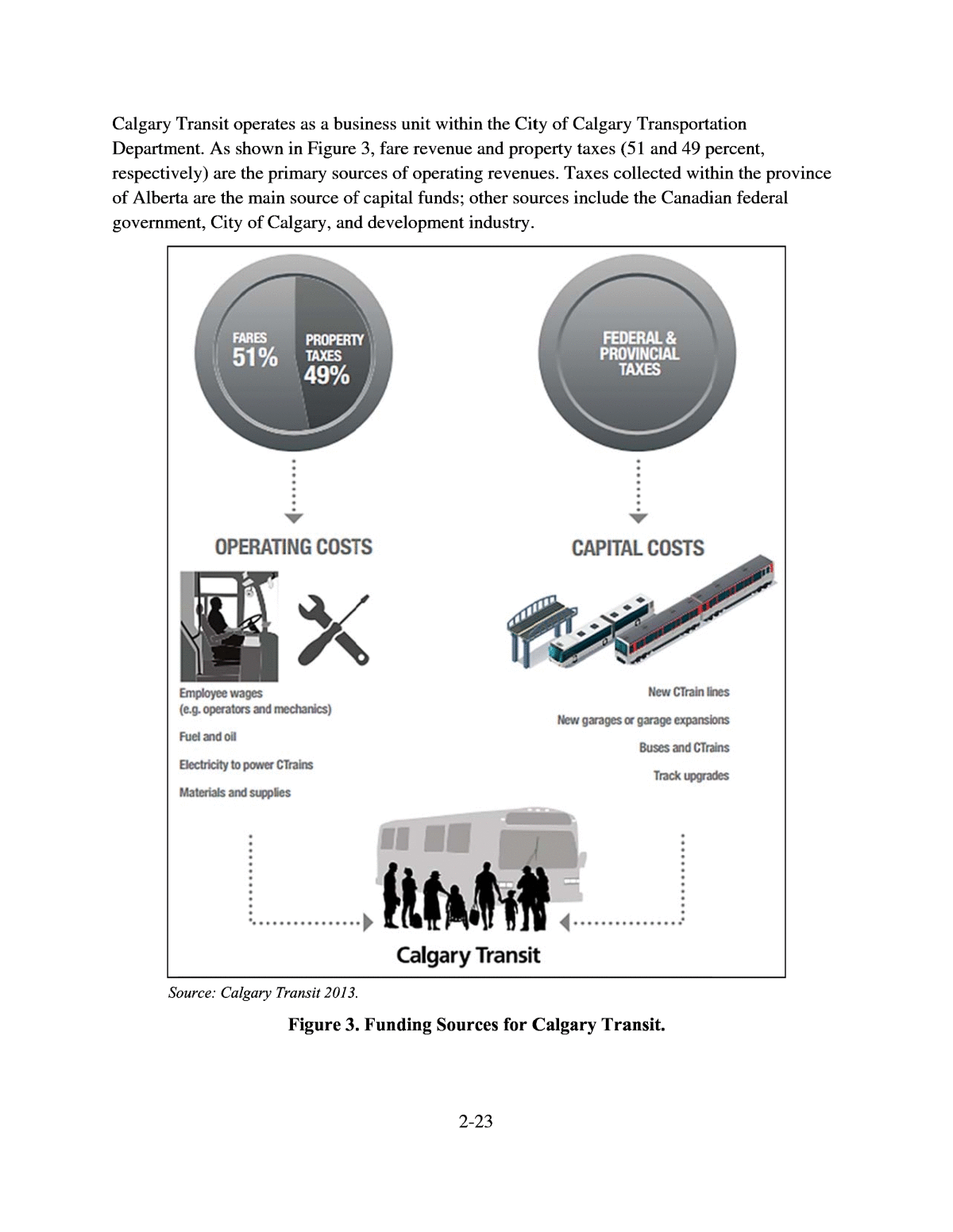
Calgary T Departm respectiv of Albert governm So ransit oper ent. As show ely) are the a are the ma ent, City of urce: Calgary ates as a bus n in Figure primary sou in source of Calgary, and Transit 2013. Figure 3. iness unit w 3, fare reve rces of oper capital fund developme Funding S 2-23 ithin the Cit nue and prop ating revenu s; other sou nt industry. ources for C y of Calgary erty taxes ( es. Taxes co rces include algary Tra Transporta 51 and 49 p llected with the Canadi nsit. tion ercent, in the provi an federal nce
2-24 Governance Calgary Transit is a transit system owned and operated by the City of Calgary and has over 3,000 employees, making it the largest public business unit in Calgary. Calgary Transit works with the Calgary Regional Partnershipâan organization comprised of 13 municipal members, Airdrie Transit, the Government of Alberta, and the Calgary Airport on improving connections within the light rail network (Stantec 2013). Transit Modes Calgary Transit provides service to virtually anywhere in the City of Calgary using a network of transit services including 155 bus routes, five bus rapid transit (BRT) routes, and two light rail lines (called CTrain). The CTrain system consists of 45 stations that cover 37.22 miles (59.9 km), 28 park-and-ride lots (five of which are privately owned), and a transit fleet of 1,203 active vehicles, including buses and light rail trains (Calgary Transit 2015). All park-and-ride facilities provide amenities including sidewalk access, bicycle access and parking, safety features to assist crossing streets, lighting, and drop-off areas (Calgary Transit 2016). Service operating statistics by mode were not available; however, Table 4 shows Calgary Transitâs total operating statistics for all modes combined. Table 5 documents Calgary Transitâs transit fares for fixed-route service (values are in Canadian dollars). Table 4. Calgary Transit Total Service Operating Statistics for 2014. Vehicles Operated in Maximum Service Annual Unlinked Trips Annual Vehicle Revenue Kilometers Annual Vehicle Revenue Hours Operating Expenses Fare Revenues System Total 839 110,461,165 56,154,956 2,524,296 $371,525,137 $175,771,109 Source: Calgary Transit from reports provided by the Canadian Urban Transit Association. Table 5. Calgary Transit Fares. Service Fare 90-Minute Ticket $3.15 Day Pass $9.50 Airport $9.50 Source: Calgary Transit 2016. Park-and-Ride Calgary Transit has offered customers park-and-ride access to transit service since the mid-1970s, when the first parking service was provided for Blue Arrow bus customers. Blue Arrow was an express shuttle created to serve downtown and the suburbs during rush hour. Since then, park-and-ride lots have been expanded as the Blue Arrow bus services were extended to northeast and northwest Calgary, and these lots now serve light rail stations (Calgary Transit
2-25 2016). Currently, Calgary Transit provides park-and-ride facilities at 33 locations, with 17,524 spaces located at CTrain stations and several major bus terminals (Table 6) (Calgary Transit 2016). Park-and-ride customers represent about 15 percent of CTrain customers. Table 6. Calgary Transit Park-and-Ride Inventory. Parking Type Facilities Parking Spaces Area in Acres CTrainâPublicâSurface 19 12,583 126.7 CTrainâPublicâStructure 2 996 3.0 CTrainâPrivateâSurface 5 1,600 16.0 BusâPublicâSurface 7 2,345 23.5 Totals 33 17,524 169.2 Source: Calgary Transit 2016. OPERATING CONTEXT FOR PARK-AND-RIDE Factors That Impact Park-and-Ride Factors that impact the way Calgary Transit manages its park-and-ride facilities include (Calgary Transit 2016): ï· The high value of the property around CTrain stations and major bus stops, which limits the amount of land devoted to parking, limits opportunities for TOD. ï· Additional parking at transit stations is weighed against adjacent traffic impacts to the community. ï· Approximately 10 percent of park-and-ride customers come from outside Calgary and therefore benefit from park-and-ride facilities because they have no other means of accessing transit. (A review is underway to manage and coordinate with regional users.) Hence, Calgary has a downtown parking policy that restricts the quantity of parking in downtown. Calgary has residential parking programs that make it harder to park in communities, which drives demand for park-and-ride. Calgary Transit is part of the cityâs Transportation Department, which makes it easier for the city council to coordinate parking policies for park- and-rides, communities, downtown, etc. Calgary is a single city of about 1.2 million people surrounded by 13 much smaller municipalities. One of the challenges for effective regional coordination of a park-and-ride program is to have consistent communication with other agencies involved in the planning and managing of park-and-rides. Currently, Calgary Transit works with the Calgary Regional Partnership and regional municipalities to integrate transit services in the city and the region. This collaboration includes providing assistance to regional partners on planning and service design, providing space at bus and CTrain terminals, coordinating with future commuter rail projects, and working toward fare integration (Calgary Transit 2013).
2-26 In 1986, a policy that provides guidelines for the rationale, quantity, and location of park-and- ride facilities was established. Calgary has been part of the discussion with other regional authorities to revise this policy to include management and planning (Calgary Transit 2016). Calgary Transit manages collection and processing of park-and-ride revenues and customer service related to parking payment (Calgary Transit 2011). In addition, the City of Calgaryâs Transportation Department is made up of four business units, including CT, that plan, design, build, operate, and maintain Calgaryâs transportation system and the Calgary Parking Authority, who provides parking enforcement of the spaces reserved by monthly paying members (Calgary Transit 2016). Calgary Transit evaluates park-and-ride performance using several indicators, including: ï· Percent of lot reserved. ï· Waiting list count for reserved parking by lot. ï· Percent of lot full before/after 10:00 a.m. ï· Reserved parking revenue. ï· Customer service requests (complaints/commendations). ï· Enforcement actions taken. ï· Reserve parking compliance. Calgary Transit issues a monthly performance report summarizing these reserve parking indicators. Table 7 shows an example of the report for October 2015. Calgary Transit also measures performance of the transit service it provides, using metrics such as service hours per person, transit trips per person, passengers per hour (of service), and net operating cost per hour (Calgary Transit 2013).
2-27 Table 7. Calgary Transit Monthly Reserved Parking Statistics for October 2015. Park-and-Ride Lot Total Lot Capacity Maximum Reserved Stalls October 2015 Reserved % of Reserved Capacity Reserved Waiting List Red Line Northwest Tuscany (Rocky Ridge) 280 107 117 109% 453 Tuscany (Tuscany) 358 179 155 87% 680 Crowfoot 1,345 672 642 96% 0 Dalhousie 740 370 289 78% 0 Brentwood 980 490 317 65% 0 Total Northwest 3,703 1,818 1,520 84% 1,133 Red Line South Somerset-Bridlewood 913 456 503 110% 1,840 Shawnessy 200 100 111 111% 741 Fish Creek-Lacombe 1,130 565 519 92% 0 Canyon Meadows 260 130 160 123% 0 Anderson 1,665 833 234 28% 0 Southland 650 325 151 46% 0 Heritage 550 275 62 23% 0 Chinook 320 160 56 35% 0 39 Avenue 279 139 29 21% 0 Total South 5,967 3,025 1,825 60% 2,587 Blue Line West 69 Street (Parkade) 737 368 443 120% 2,434 69 Street (Surface Lot) 90 45 44 98% 1,650 Sirocco 365 182 214 118% 14 Total West 1,192 595 701 118% 4,098 Blue Line Northeast Saddletowne 130 65 50 77% 0 McKnight-Westwinds 949 474 5 1% 0 Franklin 550 275 18 7% 0 Total Northeast 1,629 814 73 9% 0 Total All Lots 12,491 6,252 4,119 66% 7,818 Source: Calgary Transit 2013. Aspects of Parking Management Calgary Transit and the City of Calgary have several sections or departments that collectively manage all aspects of parking. The responsibility for different functions is shared as follows: ï· Planning for New Lots. New parking facility planning is usually done in conjunction with an extension of the light rail and is included in project design specifications. The City of Calgaryâs Transportation Planning section manages the planning aspects of parking in conjunction with Calgary Transit. ï· Construction. Construction is usually done during an extension of the light rail and is managed by the City of Calgaryâs Transportation Infrastructure section and Calgary Transit. ï· Operations. Various groups within Calgary Transit support park-and-ride operations, including service design, planning, and infrastructure maintenance.
ï· E ï· R su ï· T w Park-a Calgary T light rail risen con ridership Westwin trend, wi All park- 100 perce is availab nforcement. eal Estate. T pports the m OD. The Cit ith Calgary nd-Rid ransit prov have impact tinuously sin for the bus ds and Some th light rail d Source: Free Fi and-ride fac nt. Demand le in up to 5 Calgary Par he Real Est anagement y of Calgary Transit lead e Trans ides parking ed light rail ce 2001. B system. This rset-Bridlew emand exc mark 2014. gure 4. Calg ilities have v for parking 0 percent of king Autho ate Develop of real esta âs Real Est s TOD. it Modes at both bus parking pol y mid-2007, growth wa ood. Since eeding bus d ary Transi arying amo is higher at the lot. 2-28 rity manage ment Servic te. ate Develop and light ra icies. As see light rail rid s due to exte 2009, both emand (Fre t Services R unts of free light rail st s parking en es Division ment Servic il stations; h n in Figure ership had nsions of C systems hav emark 2014 idership 1 parking ran ations; there forcement. within the C es Division owever, rid 4, light rail grown more Train servic e followed a ). 996â2013. ging from 5 fore, paid re ity of Calg in conjuncti ership trend ridership ha than the e to McKni bout the sam 0 percent to served park ary on s in s ght- e ing
2-29 Passenger Amenities All facilities provide a common set of amenities including sidewalk access, bicycle access and parking, safety features to assist crossing streets, lighting, and drop-off areas. Some facilities have additional amenities, including: ï· Covered or enclosed waiting areas. ï· Permanent restrooms. ï· Electric vehicle charging. ï· Carsharing services. ï· Lockers or enclosed parking for bicycles. ï· Parking for transit customers to access the intercity bus. None of the facilities has temporary restrooms, on-site station personnel, concessions, or vending machines. Customer Feedback Calgary Transit uses many sources of customer feedback, including several types of surveys. In November 2015, Calgary Transit conducted a survey of CTrain customers to learn more about how they access light rail transit (LRT) and their opinions on the mode they currently use, the mode they would prefer to use, and potential improvements they would like to see. This online survey received 5,550 responses. Calgary Transit also occasionally conducts park-and-ride surveys and safety, security, and cleanliness surveys in addition to an annual customer satisfaction survey. Additionally, Calgary Transit asks individuals to voice concerns/recommendations via telephone, in its offices, or online. Security and Enforcement Roaming security officers enforce parking policies and practices, and no facilities have dedicated on-site security personnel. To enforce parking regulations, Calgary Transit uses random mobile patrol, license plate recognition, and other matching technology. Eligible Access to Park-and-Ride All park-and-ride facilities have bicycle access, bicycle parking, and kiss-and-ride drop-off areas. Some facilities have carsharing services, electric vehicle charging spaces, and parking for transit customers to access the intercity bus. Carsharing companies are one option to address first-mile/last-mile connectivity. Carsharing companies available in Calgary are Student CarShare, Car2Go, and Enterprise. Calgary Transit is also currently investigating opportunities with transportation network companies.
2-30 Calgary Transit has received requests for other non-standard parking facilities such as for special events, school buses, charity clothing drop-offs, food vendors (e.g., food trucks), taxis, short- term use, and loading zones. So far, none of these options has been implemented. During station area planning, Calgary Transit conducts an assessment of needs and customer requests to see if any of these parking requests may be incorporated. Sources of Funding for Park-and-Ride Management Calgary Transitâs park-and-ride facilities require an annual operating expenditure of up to $11 million to maintain elevators, heating, cooling and fire detection, and suppression systems (Calgary Transit 2013). The primary sources of operating revenue are fare revenue and property taxes. Fare revenue covers approximately half of Calgary Transitâs operating costs, while the remaining half is covered by municipal property taxes. About 4 percent of operating funds come from advertising on vehicles, shelters, and stations. Reserved paid parking, available at some park-and-ride facilities, also contributes to operating revenue. Notable Practices Calgary Transit monitors its overall and its park-and-ride performance on a regular basis and issues a monthly performance report summarizing reserved parking statistics. Calgary Transit provides first-mile/last-mile connections and options for its customers. All park- and-ride facilities have at least bicycle access and parking. Additional options include carsharing at some facilities, and Calgary Transit is investigating transportation network companies as another alternative. Calgary Transit has a robust customer feedback program through its surveysâboth annual and ad hoc. Calgary Transit targets some surveys to specific issues (e.g., safety) and customers (e.g., park-and-ride users) to gain more in-depth insights. Lessons Learned Calgary Transit now charges for reserved parking at its park-and-ride facilities because the transit agency has determined that park-and-ride is a premium service in high demand. This revenue now contributes to facility maintenance expenses. Thanks to customer feedback, Calgary Transit improved security with more frequent security patrols, resulting in a significant decrease in auto theft and vandalism (Calgary Transit 2016). SHARED USE OF PARK-AND-RIDE FACILITIES Calgary Transit has limited experience with shared-use park-and-ride facilities at privately owned parking lots. Calgary Transit has agreements with private property owners for the use of parking spaces; however, Calgary Transit does not pay for the spaces. The private property
2-31 owner benefits from charging the customers for parking and increased business in retail shops and stores. There are current efforts to further explore opportunities of shared use of parking and optimize land use around transit stations in the Calgary region. Calgary Transit park-and-ride planners are willing to work with communities and stakeholders on activities related to shared-use park-and- ride facilities such as engagement, surveys, information sessions, and open houses. Calgary Transit and the City of Calgary have an existing shared-use arrangement for park-and- ride facilities including theaters, parks, shopping malls, churches, community centers, hotels, and restaurants. Calgary Transit works with the other city business units to respond to issues arising from park-and-ride, such as the ones faced in 2008 related to auto crime and security concerns. CHARGING FOR PARKING Charging for parking helps transit agencies regulate parking capacity and have additional funding for maintenance and security of park-and-ride facilities. A successful parking strategy requires a balance of the amount of free and paid parking and selection of an optimal parking fee. Policy to Charge for Parking Calgary Transit provides its customers with 15,179 parking spaces at 26 CTrain stations and seven lots adjacent to major bus routes. A maximum of 50 percent of these spaces may be reserved for a fee, as clarified below. Calgary Transit also teamed with several private entities (e.g., University of Calgary, Calgary Zoo, and several shopping centers) to provide an additional 2,693 parking spaces mostly for a fee. Calgary Transit has agreements with these private entities but does not pay them. The private property owner benefits from charging the park-and-ride customers directly or through increased business. There are five private lots near light rail stations and one near a bus station. Light rail lots have both free parking and reserved parking. About 50 percent of light rail parking spaces are designated as reserved parking from 2:00 a.m. to 10:00 a.m. on weekdays. Reserved parking spaces become free parking spaces after 10:00 a.m., on weekends, and on holidays. Reserved spaces cost $85.00 ($66.52 US) per month. If any spaces are still not taken at 10:00 a.m., they become available free of charge. Having some free parking minimizes barriers to the use of public transit and encourages people to use transit even if they need their personal vehicles for some part of their journey. The decision to charge for parking was prompted by a few factors, which included (Calgary Transit 2016): ï· All light rail and some BRT lots were filling up to capacity. ï· An additional source of revenue was required to maintain facility quality. ï· Auto crime was increasing in the lots.
2-32 ï· Customers had concerns with station security, maintenance, and cleanliness. To balance ridership goals with the decision to charge for parking, Calgary Transit allows 50 percent of LRT parking spaces in each lot to be reserved during certain times of the day. Customers were requesting reserved spaces to help ensure the availability of parking, so charging for parking is beneficial for customers and for Calgary Transit. Customers have been more satisfied with the Calgary Transit system after reserved parking was made available. Moreover, some parking is free, enabling those who might ride less to continue using public transit (Calgary Transit 2016). Methods to Collect Parking Charges Payments for reserved parking may only be done online using the reservation system managed by Calgary Parking Authority, called the ParkPlus System (Calgary Transit 2016). Parking fees and transit fares are separate fees. If a space is available, the customer may reserve the space and pay month to month or for several months at one time. If a space is not available at the preferred lot, the customer may request to be placed on a waiting list. Once a space becomes available, an email will be sent to advise the customer of the available parking space (Calgary Transit 2016). Calgary Transit does not package transit fares and parking fees together and offers no discounts or special pricing programs for purchasing both transit and parking. In order to determine the appropriate fee strategy, Calgary Transit established parking fares to be competitive with downtown parking. Calgary Transitâs parking fees are assessed bi-annually in conjunction with its fare policy. Public Outreach Calgary Transit conducted an online survey on the park-and-ride reserved parking program in October 2011, six months after the reserved parking policy began (Calgary Transit 2011). The survey provided many insights into customer perceptions. The evolution of the park-and-ride service from completely free, to pay-per-use, to a reserved/free service has certainly influenced the travel patterns and opinions of many Calgary Transit customers who use light rail park-and- ride. The survey also suggested the park-and-ride system is under strain because demand exceeds supply. There is a considerable divide in values and perceptions between those respondents who felt that free parking is a right versus those respondents who liked the choice of reserving a space. The survey responses clearly showed that reserved parking respondents were generally free of stress and frustration despite a few who had suggestions to make it a better experience. On the other hand, free parking respondents typically voiced frustration and anger at their experiences since reserved parking became an option. The survey assessed which factors affected the decision of whether to purchase a reserved parking space. Cost was the main factor deterring free parking users from reserving a space.
2-33 Notable Practices Calgary Transit uses the ParkPlus System, an online reservation system managed by Calgary Parking Authority. The reservation system easily allows the management of reserved parking spaces and fee payments. Lessons Learned To balance ridership goals with the decision to charge for parking, Calgary Transit allows up to 50 percent of light rail parking spaces in each lot to be reserved during certain times of the day (from 2:00 a.m. to 10:00 a.m. on weekdays). PLANNING AND ESTIMATING DEMAND FOR PARKING In terms of park-and-ride demand, Calgary Transit offers between two to 15 times more parking than any other Canadian transit system including cities such as Vancouver, Edmonton, Winnipeg, Toronto, and Ottawa (Calgary Transit 2016). This section describes the process Calgary Transit uses to plan for park-and-ride facilities. Methodology to Estimate Demand Calgary Transit planning staff uses an in-house demand model developed in 1986 to estimate demand for park-and-ride facilities. Calgary Transit parking policy guidelines are available online http://www.calgarytransit.com/calgary-transit-park-ride-policy. The policy states that âparking lots should be located beyond 5 kilometers (3.13 miles) of the downtownâ and âthe amount of parking at each station [should] be capable of serving between 15 and 20 percent of the estimated transit trips generated by the area served by the station.â The monthly reserved parking system allows up to 50 percent of light rail parking spaces to be reserved at all LRT stations and provides about 33 percent of parking lot users with the certainty and convenience associated with having a guaranteed place to park (Calgary Transit 2016). This process ensures that the majority of light rail parking lots and most BRT lots are full to capacity by 10:00 a.m. on weekdays. Predicted demand is estimated during functional planning. The actual usage is consistently monitored. Calgary Transit based its demand estimations on two main assumptions: ï· Too much parking can detract from the general goal of minimizing auto use (negatively impacting local communities, TOD, and ridership on feeder buses). ï· Too little parking may restrict the transit ridership in a corridor.
2-34 The provision of park-and-ride requires striking a balance between providing a service to meet demand and recognizing costs and other implications. Calgary Transitâs overall strategy is to provide 15 percent of weekday light rail users with park-and-ride services. The target horizon year Calgary Transit uses for planning park-and-ride is 30 years from the conception of a line or project, keeping customer requirements in mind on opening day. The advantage of using a 30-year target horizon is that Calgary Transit is able to plan adequate space for future park-and-ride demand. On the other hand, one of the disadvantages is that Calgary Transit assumes the risk of providing too much parking and not anticipating technology changes. Considerations When Planning a Park-and-Ride Calgary Transit considers several factors when planning park-and-ride facilities at CTrain stations and major bus stops: ï· Overall system park-and-ride target. ï· Projected station or stop ridership. ï· Station or stop location relative to downtown or a major attraction, which will influence the facilityâs ability to intercept trips and reduce downstream traffic volumes. ï· Projected station or stop parking demand based on: o Is the station an attractor or generator of trips to or from the area? o What is the population within the station or stop service area? o What is the quality of the current and planned feeder bus service to the station or stop service area? o Is the station a terminal stationâshort term vs. long term? ï· Capacity of the adjacent roadway network to accommodate traffic generated by a park- and-ride lot. ï· Availability of land located within a five-minute walk of the station or stop. ï· Nature and density of adjacent land use. ï· Potential for TOD within the station area. ï· Placement of parking within the station area, considering: o Avoiding the prime TOD land. o Ensuring entrance/egress opportunities. o Enhancing pedestrian connectivity. ï· Appropriate parking formâsurface, above grade, or below grade structure. ï· Opportunity for private sector to provide parking to transit customers. Benefit-Cost Analysis When considering the initial cost versus benefits of providing parking, the initial goal of Calgary Transit to provide parking for 15 to 20 percent of weekday peak-period customers appears to have been appropriate and effective for a new light rail system in its beginning stages. This ratio
2-35 may continue to be appropriate for terminal stations serving new and developing communities with limited bus service and to serve customers traveling to Calgary from outside the city limits. However, this amount of parking may not be appropriate for stations located closer to the inner city, with land use plans calling for higher density and more compact development. Also, the cost of constructing and maintaining a park-and-ride is considered an investment that can be weighed against the alternative of adding road capacity and downtown parking facilities (Calgary Transit 2016). In measuring cost performance of the transit network, the ongoing operational costs of park-and-rides are distributed across the entire network of transit services, regardless of whether the transit route serves the park-and-ride. Factors That Influence Demand Corridor congestion and downtown parking supply and cost are significant factors affecting park-and-ride demand. Downtown parking charges have been critically influential in the success of transit ridership into downtown. There is no freeway into the downtown area of Calgary, which leads to corridor congestion parallel to the light rail network, further supporting the use of park-and-rides. A high level of road capacity in suburban areas drives higher demand for park- and-ride. Predicted Versus Actual Experience All predicted demand is estimated during the functional planning phase. In order to have a validation of the in-house demand model, Calgary Transit consistently measures park-and-ride facility utilization. When Calgary Transit finds a case where one or more facilities exceeds demand, it proceeds to charge for parking, use security (parking enforcement) to prevent street parking, and make 50 percent of parking spaces at a light rail station available for reservation for a monthly fee. Calgary Transit has recently called for a review of its criteria for estimating park-and-ride demand by reevaluating existing and future facilities and incorporating the impacts on TOD and adjacent communities. Expanding Park-and-Ride Capacity Calgary Transit usually plans for expanding park-and-ride facilities when light rail service is extended. Expansion plans are also guided by long-range planning. Transportation demand management (TDM) strategies are ongoing and are explored when the opportunity arises. Various factors affect Calgary Transitâs decision to build the various types of parking facilities: surface lot, aboveground garage, underground garage, or a combination. Factors include capital costs to build, operating costs to maintain, transit demand, land value, future TOD plans, and anticipated changes in vehicle usage. Per capita vehicle ownership in Calgary is high and contributes to an increase in demand for park-and-ride.
2-36 The net cost of operating park-and-ride reduces the funds available to provide core bus and CTrain services. The decision for parking facility type becomes a balance of the above factors; however, cost is a significant element. Notable Practices Calgary Transit has developed a rule of thumb based on its vast experience estimating parking at each station. Between 15 and 20 percent of the estimated transit trips generated by the area served by the station will use park-and-ride facilities. Lessons Learned Calgary Transit identified that the primary demand for park-and-ride arises from downtown employees, and procedures for estimating demand from this market are based on a historical 15 to 20 percent park-and-ride access to transit mode share. Demand tends to be unlimited if parking is free. MANAGING DEMAND FOR PARKING Transit Parking Management Strategies TODs typically result in several times more ridership than would be generated from land devoted to parking. In this context, a park-and-ride lot next to an LRT station is not the best use of this land. Ridership is also dependent on quality of bus service to the station. According to the transit agencyâs experience, the quality of bus service has more of a positive impact on ridership. Calgary Transit addresses a balance of all the different factors that influence park-and-ride demand. Transportation Demand Management The City of Calgary has a TDM working team that works closely with Calgary Transit to enhance TDM. Calgary Transit also sits on development review teams that review development applications. Ridership and service are tied to the strength of the economy. Customers who lose jobs ride less or rely on previous investments in personal automobiles for transportation. Calgary Transit has conducted an analysis of the quantitative relationship between providing parking and levels of transit ridership. The analysis revealed that there is no relationship between the supply of parking (park-and-ride) and total LRT station ridership. Unexpectedly, the 10 stations with highest ridership have parking for 7 percent of the customers boarding at these stations. As mentioned previously in this document, Calgary Transit provides parking for 15 percent of light rail customers.
2-37 Station Typologies and the Impact on Demand for Parking Calgary Transit conducts functional planning along LRT lines and works with adjacent landowners and development authorities to determine station locations (and, consequently, park- and-ride). Although the transit agency has not provided documentation on the positive impact on ridership, Calgary Transit considers that providing parking or providing improved access for pedestrians, bikes, local/private transit, and other modes has a helpful impact on ridership. STANDARD OPERATING PROCEDURES Calgary Transit does not have formally documented standard operating procedures except for a document last updated in April 2006 called the Transit Friendly Design Guide (Calgary Transit 2006). The document states Calgary Transitâs commitment to minimize environmental impacts of urban travel at the planning stage of Calgary Transitâs projects by providing a lower-cost travel option to individuals and the Calgary community. With the application of the principles and policies included in the Transit Friendly Design Guide, Calgary Transit seeks to increase the regional transit mode share, reduce private auto dependency, and be environmentally responsible. The Transit Friendly Design Guide introduces a model for new suburban communities that will be designed and developed to reduce the need to drive. Lessons Learned Calgary Transit has increased transit service without actively pursuing the community design elements laid out in the Transit Friendly Design Guide. The absence of transit-friendly design impedes Calgary Transitâs desired modal shift to transit. IN-HOUSE PARKING MANAGEMENT Calgary Transit directly manages and operates all of its 33 park-and-ride facilities except for five CTrain park-and-rides, which are privately owned. Therefore, Calgary Transit provides all of the administration, maintenance, and utilities for 28 of its facilities. The average daily operating cost per parking space is about $3.00 ($2.33 US) for surface lots and $8.00 ($6.21 US) for structured parking. Table 8 shows the average annual cost for various operating expenses.
2-38 Table 8. Calgary Transit Annual Operating Costs for Parking. Item (Annual) Surface Parking Stall Structured Parking Stall Maintenance $500 $825 Gas + Electric $75 $250 Administration $25 $25 Miscellaneous $75 $150 Depreciation $150 $825 Annual Totals $825 $2,075 Daily Equivalent $3.30/weekday $8.30/weekday Note: Canadian Dollars. Source: Calgary Transit 2016. DESIGN FEATURES Calgary Transit has established some specific design guidelines for its park-and-rides that address safety and sustainability. Design Features for Safety Calgary Transit designs its facilities to address passenger safety and security, comfort, and mobility requirements. As previously mentioned, all facilities have sidewalk access, bicycle access and parking, and safety features for street crossings, lighting, and drop-off areas. Calgary Transit follows the regulations and standards of Crime Prevention through Environmental Design, the Transportation Association of Canada Standards, and the signage and road marking standards in the Manual on Uniform Traffic Control Devices. Design Features for Sustainability In 1995, the City of Calgaryâs Planning and Building Department developed a document to facilitate the design of new residential communities that address fiscal, social, and environmental sustainability issues. The document contains policies for public services including park-and-ride facilities. Table 9 summarizes the characteristics that the City of Calgary pursues for the construction of more sustainable communities (including transit facilities).
2-39 Table 9. Some Characteristics of a More Sustainable Community in Calgary Region. A More Sustainable Community (including Transit Facilities) Fiscal Lower costs through: More compact urban form Better utilization of services Less infrastructure Social Strong sense of belonging to a community; vibrant community life Attractive public areas that encourage walking and socializing Most routine shopping needs met within the community Some mixed-use, including employment Reduce the need for car Environmental More efficient use of land Reduced air pollution through reduced vehicle trips Significant environmentally sensitive areas largely protected and integrated into the regional open space system Adapted from City of Calgary, Planning and Building Department (1995). Public Involvement in Features Design Calgary Transit uses public feedback during the park-and-ride design process through surveys, engagement (face-to-face and online), informational sessions, and community consultation committees. These committees consist of community representatives who provide Calgary Transit with feedback on study findings through the planning process to share neighborhood concerns. PARK-AND-RIDE CAPITAL INVESTMENT For Calgary Transit, the capital cost of constructing park-and-ride facilities is significant. The construction cost per space is about $15,000 ($11,652 US) and $50,000 ($38,839 US) for surface and structured parking, respectively (Calgary Transit 2016). Construction costs may be higher in a TOD situation or a more developed area because land costs are typically higher adjacent to an established transit hub. Calgary Transit recognizes that to provide access to a CTrain station, the capital cost of providing parking is considerably more expensive on a per-customer basis than purchasing buses to transport customers to a station (i.e., using feeder or circulator routes). Table 10 displays Calgary Transitâs typical capital costs for a 500-stall parking facility (Calgary Transit 2016).
2-40 Table 10. Calgary Transit Park-and-Ride Capital Investment. Surface Parking Structured Parking LAND COSTS 500 Stalls 5 acres$5 million 1 acre $1 million Per Stall $10,000 $2,000 CONSTRUCTION COSTS 500 Stalls $2.5 to $7.5 million $25 to $40 million Per Stall $5,000 to $15,000 $50,000 to $80,000 Note: Canadian Dollars. Source: Calgary Transit 2016. Lessons Learned At $15,000 per space for surface parking and $50,000 per space for structured parking (in Canadian dollars), the capital cost of providing parking at a CTrain station is considerably more expensive on a per-customer basis than purchasing buses to transport customers to a station. TRANSIT-ORIENTED DEVELOPMENT Calgary Transit defines TOD as âa walkable, mixed-use form of development typically focused within a 600-meter radius of a Transit Station â an Light Rail Transit (LRT) station or Bus Rapid Transit (BRT)â (City of Calgary, Land Use Planning & Policy 2005). Investment in TOD The City of Calgary City Council adopted the TOD Policy Guidelines in December 2004 (City of Calgary, Land Use Planning & Policy 2005). The purposes of these guidelines are: ï· To reaffirm the importance of the light rail system and stations as citywide assets and the need to optimize the use of this investment through supportive land use policies. ï· To establish broad, citywide policies and guidelines for the future intensification and development of lands in the vicinity of transit stations. ï· To create certainty in transit station areas for local communities, landowners, and developers by clarifying the cityâs objectives for land use and development around stations. ï· To provide a framework for evaluating land use, development permits, and subdivision applications in transit station areas. ï· To direct policy development of station area plans for new and existing transit station areas, and the preparation of, or amendments to, area redevelopment plans and area structure plans. These guidelines assist the City of Calgary in the process of evaluating proposed developments in station planning areas. A station planning area is roughly defined as the land within a 600 m
2-41 (1,969 ft) radius of a light rail or BRT station. The TOD Policy Guidelines help to develop new land use objectives for proposed amendments to existing or new area redevelopment plans and to assess the merits of the redevelopment plans from a TOD perspective. The guidelines will respect existing, established communities but will enforce with requests for land use re- designation. The guidelines emphasize the benefit of a more comprehensive planning process that includes more than just looking at individual sites. These guidelines are also intended to supplement the evaluation criteria for subdivision and development permit applications of properties that are part of transit station areas. Parking Replacement Policies Calgary Transitâs TOD policy (City of Calgary, Land Use Planning & Policy 2005) suggests that TOD places more emphasis on developing walkable areas close to transit stations that can be used for purposes other than parking. Transit bus and private automobile circulation and parking need to be accommodated while at the same time creating a comfortable pedestrian environment. TOD, through its transit-supportive land uses, increased density, and pedestrian design, provides active mobility options and reduces automobile trips through increased transit ridership and the potential for decreased vehicle ownership. In addition to proximity to a transit station, parking policy relaxation should be considered when a site has additional location or parking management characteristics such as: ï· Shared parking where different uses require parking at different times of the day. ï· Proximity to park-and-ride lots that could be considered for parking during off-peak hours. ï· On-street parking within TOD station areas as part of the parking supply for a development. ï· Longer-term secure bike parking with shower and locker facilities. To help reduce the need for on-site parking in TOD areas, Calgary Transit recommends the following strategies: ï· Encouraging local shuttle service for employment or shopping centers. ï· Facilitating community carsharing and carpooling by providing preferential parking spots for carshare and carpool vehicles. ï· Promoting TDM initiatives such as flex-time hours, telecommuting, bike or walk to work programs, etc. ï· Working with businesses to encourage transit ridership programs for employees. Parking Placement in a TOD Placement of parking in TOD is also important to maintain desired density and pedestrian comfort within the station area. Calgary Transit ensures that major parking areas can be accessed from collector and arterial roads in the perimeter of the station areas, without impacting existing
2-42 communities or the pedestrian environment closest to the station. Direct and convenient pedestrian connections should lead from these parking areas to primary destinations such as the transit station, major office areas, high-density residential areas, etc. Parking lots should be located to the rear or side of the building along primary pedestrian routes that lead to transit stations, and parking lots should be designed and located to minimize the number of vehicle crossings over primary pedestrian routes. Notable Practices Developers in Calgary have two sources for additional guidance in TOD: the Transit Oriented Development Best Practices Handbook (January 2004) and Transit Oriented Development (TOD) Policy Guidelines (December 2005). The City of Calgary City Council adopted the TOD Policy Guidelines (City of Calgary, Land Use Planning & Policy 2005). The commitment to create great places to live led Calgary Transit to structure a TOD framework to help Calgary communities, city staff, and city council make decisions on development proposals around existing and future important transit stations. Challenges or Lessons Learned There are several challenges that make successful TODs difficult to implement. First, market demand largely drives TOD development. Not every station will work as a TOD, and having the appropriate market for different types of development in a station area is necessary to get a TOD going. In addition, timing of market demands makes it difficult. Local market demand is constantly changing, and what might work as a TOD today might not work a year from now. Last, there may also be community opposition to TOD projects. Residents and other stakeholders may be concerned about traffic impacts, changes to transit service, increases or decreases in parking, or other issues. INNOVATION Commuters reserve space at a park-and-ride facility using an online reservation and payment system. Calgary Transit enforces parking regulations using random mobile patrol, license plate recognition, and matching software. Calgary Transit is committed to environmental preservation. Calgary Transit recycles all paper products left at park-and-ride facilities, recycles water for non- potable purposes, and collects rainwater for landscaping and irrigation at its transit facilities. Calgary Transit offers two parking options: reserve or free (first-come, first-served). Parkers with reserved parking service use their designated spot on a daily basis. The transit agency is planning to use technology to have parking spots rotate so parkers do not necessarily have to use the same spot every single day. The transit agency has no other plans to implement other technologies
2-43 (e.g., new fare payment media, mobile ticketing, or a real-time parking availability system) in the near future. SUMMARYâNOTABLE PRACTICES Calgary Transit has several notable practices in place in its planning and management of park- and-ride facilities. They are itemized below: ï· Calgary Transit issues a monthly report summarizing performance of the reserved parking program. ï· Calgary Transit uses the ParkPlus System, an online parking reservation system managed by Calgary Parking Authority, to manage the demand and supply of parking spaces and to allow users to reserve and pay for their parking spaces. ï· The City of Calgary City Council adopted the TOD Policy Guidelines. The commitment to create great places to live led Calgary Transit to structure a TOD framework to help Calgary communities, city staff, and city council make decisions on development proposals around existing and future important transit stations. ï· The Transit Friendly Design Guide, along with the TOD Policy Guidelines, describes the strategies, techniques, and policies that will help create transit-supportive development and a transit-friendly design for the City of Calgary. ï· The Transit Friendly Design Guide seeks to introduce a model for new suburban community design and development that reduces the need to drive. ï· Calgary Transit developed systematic methodologies and criteria when planning park- and-ride facilities at each station and major bus stop. SUMMARYâLESSONS LEARNED In its work planning and managing park-and-ride facilities, Calgary Transit has learned some valuable lessons. They are itemized below: ï· Calgary Transit now charges for reserved parking at its park-and-ride facilities because the transit agency has determined that park-and-ride is a premium service in high demand. This revenue now contributes to facility maintenance expenses. Thanks to customer feedback, security improvements have been made with more frequent security patrols, resulting in a significant decrease in auto theft and vandalism. ï· To balance ridership goals with the decision to charge for parking, Calgary Transit allows 50 percent of LRT parking spaces in each lot to be reserved between 2:00 a.m. and 10:00 a.m. on weekdays. ï· Demand tends to be unlimited if parking is free.
2-44 ï· The capital cost of providing parking at a CTrain, BRT, or bus station is considerably more expensive on a per-customer basis than purchasing buses to transport customers to a station. ï· Calgary Transit identified that the primary demand for park-and-ride arises from downtown employees, and procedures for estimating demand from this market are based on a historical 15 to 20 percent (weekday peak periods) access modal share for park-and- ride. ï· Calgary Transit has increased transit service without actively pursuing the transit- supportive community design elements described in its transit-friendly design guide. Without transit-friendly design, it will be more difficult for Calgary Transit to reach its goals for transit mode share.
INTR The Conn services i transport targeted c majority modeling Case stud park-and BACK Brief D ConnDO Database coordinat in the No ConnDO several m urban, an commute ferry, and marketin CTrides i (TDM) p connectin commute operated Hartford ConnDO in the sta spring 20 DEPA ODUCT ecticut Dep n local area ation agenci ase study d of programm of park-and y efforts inc -ride deman GROU escrip T has statew but is not th es services rtheastern U T provides m onikers (Fig d large urba r bus, bus ra vanpool; a g brand to a s a transpor rogram that g commute r rail servic by Metro-N Line (a futu T-owned pr te. CTfastra 15 on a prim CONN RTME ION artment of T s and region es both in C ue to its lon ed major tr -ride deman luded phon d and collec ND tion of C ide jurisdic e only publ with other p nited States any transit ure 5) and i n contexts. pid transit ( ll services u ppear seaml tation deman also acts as rs to relevan es and will s orth Railroa re line to be ovider of loc k is a BRT s arily separa DOT â NT OF ransportati s in Connec onnecticut a g, innovativ ansportation d with the C e-based inte tion of data onnDO tion and rep ic transporta ublic transp . services un n various ru Services inc BRT), comm se a uniform ess to custom d managem a resource f t public tran oon add ser d), Shore Li operated by al bus, com ervice in ce ted bus-onl 2-45 CONN TRA on (ConnDO ticut and co nd in adjace e history of projects sin Tfastrak B rviews with from variou T orts services tion agency ortation age der ral, small lude bus, uter rail, ers ent or sportation p vice on a thi ne East (cur a ConnDO muter bus, a ntral Connec y guideway ECTI NSPO T) provides ordinates se nt states. C including pa ce the 1970 RT line. ConnDOT s relevant w to FTAâs U in the state ncies in Con roviders. C rd line: the rently opera T contractor nd BRT in ticut; the se at high freq Source: Con Figure 5 CUT RTATI public tran rvices with o onnDOT wa rk-and-ride s and its rec staff involve ebsites. rban Nation . The transit necticut and Trail current New Haven ted by Amt ). CTtransit many locati rvice began uency. n DOT . Various C ON sportation ther public s selected a facilities in ent innovat d in modeli al Transit agency adjacent st ly owns two Line (curren rak), and is the ons and regi operation in onnDOT L s a a ive ng ates tly ons ogos.
2-46 Governance ConnDOT is a statewide agency involved in all modes of transportation. The transit agencyâs Bureau of Public Transportation is ConnDOTâs lead on all matters related to public transportation services. The mission of the ConnDOT Bureau of Public Transportation is to develop, maintain, and operate a safe and efficient system of motor carrier and rail facilities for the movement of people and goods, such as bus transit, rail operations, and ridesharing programs. For ease of reading, this case study uses the term ConnDOT to specifically refer to the Bureau of Public Transportation. ConnDOT has varying levels of involvement in public transportation across the state. The transit agency serves populations and territory representing the full spectrum of rural to urban land development patterns. In some areas of the state, ConnDOT is the direct owner of public transportation services provided by contractors. In other areas, ConnDOT is indirectly involved through planning, research, and funding. There are 11 other National Transit Database (NTD) reporting agencies in Connecticut. Transit Modes ConnDOT supports various alternatives to driving alone, including express and local buses, two rail lines, and a statewide vanpool system, to reduce traffic congestion and improve mobility in Connecticut and throughout the region. ConnDOT services are provided through direct operations and through contracted services. Rail public transportation services carried about 40.3 million unlinked passenger trips in 2015 using a fleet of 405 electric cars and 68 push-pull cars. Bus ridership in FY 2015 was 31.3 million unlinked passenger trips on state-owned fixed- route urban services; 743,000 trips on Americans with Disabilities Act (ADA) complementary paratransit in state-owned urban services; and about 11.5 million on other urban, rural, and ADA system trips regardless of ownership. The bus fleet as of June 2016 consisted of 557 heavy-duty transit or commuter buses and 270 body-on-chassis light-duty buses or vans. ConnDOT services are provided in or between rural areas and six wholly or partially served urbanized areas (UZAs): ï· Hartford, CT. ï· New Haven, CT. ï· Springfield, MA-CT. ï· Waterbury, CT. ï· Bridgeport-Stamford, CT-NY. ï· New York-Newark, NY-NJ-CT.
2-47 The U.S. Census Bureau (Census) estimated the population of Connecticut to be 3,574,118 in 2010 and 3,590,886 in 2015. Therefore, the population increased by 16,768 (0.5 percent) in the five-year period; the population of the United States increased 4.1 percent during the same time period. Eighty-five percent of Connecticutâs population resides in urban areas; the other 15 percent is rural. The 2014 American Community Survey estimates 11 percent of the population is in poverty (much lower than national average). About 68 percent of the population age 16 and over is in the labor force. The mean travel time to work was 25.1 minutes (slightly lower than national average). Seventy-nine percent of commuters drove alone to work (slightly higher than national average), 8 percent carpooled, 5 percent used public transportation, 3 percent walked, 1 percent used other means, and 4 percent worked primarily at home. Table 11 documents ConnDOTâs fares for fixed-route transit services. Table 11. ConnDOT Fares. Service One-Way Fare Local Bus 2-Hour $1.50 Local Bus Day Pass $3.00 Hartford Express Bus Zone 2 $2.70 Zone 3 $3.50 Zone 4 $4.30 Zone 5 $5.15 I-Bus Express Bus 2-Hour $3.00 Day Pass $6.00 Source: Connecticut Department of Transportation 2016b. Park-and-Ride ConnDOT began including park-and-ride facilities in most transportation projects affecting highway intersections in the 1970s to facilitate carpool, vanpool, and transit use during periods of fuel shortage. The relative additional cost to incorporate a park-and-ride facility into programmed construction projects was generally considered low and the benefits were considered worthwhile. The transit agency continues to incorporate park-and-ride facilities where feasible. The transit agency now has 237 park-and-ride facilities with 34,021 parking spaces (Table 12). Of those facilities, 98 percent are lighted, 96 percent are paved, 30 percent have shelter(s), 26 percent receive express bus service, and 26 percent receive local bus service (Connecticut Department of Transportation 2016a). (Please note that the percent amounts are summary statistics and not mutually exclusive.)
2-48 Table 12. ConnDOT Park-and-Ride Facilities and Spaces. Stations/Lots Spaces Bus 82 10,284* Rail 61 18,410* Ferry 2 80* Other (non-transit) 92 5,247* Total 237 34,021 *May include spaces not served directly by ConnDOT services Sources: American Public Transit Association 2014 and Connecticut Department of Transportation 2016a. ConnDOTâs network of park-and-ride facilities serves transit customers and drivers alike. The 237 facilities are found in various locations across the state, but most occupy space in the right of way (ROW) adjacent to highway intersections or at leased private lots: ï· 8 have both express and local bus service. ï· 37 have express bus service only. ï· 37 have local bus service only. CTfastrak Park-and-Ride The case study of ConnDOT specifically targeted information on how the transit agency estimated demand for CTfastrak BRT services. CTfastrak is the first instance of BRT in Connecticut and began operation in spring 2015. The route has 10 stations and uses a 9.4-mile separated guideway. Buses operate as frequently as every four minutes during rush hour, and travel time is under 30 minutes end-to-end. Limited surface parking is available at no cost at most stations. CTtransit local and express bus routes provide access to CTfastrak from nine park- and-ride facilities with a total capacity of 1,614 spaces. The service connects a corridor region of 10 communities (Figure 6). Parking is free of charge and first-come, first-served. In addition, ConnDOT formed an agreement with the City of New Britain allowing customers to park in a municipal parking garage for a reduced rate. Weekend parking is free in the garage. Table 13 shows available parking at CTfastrak stations and park-and-ride facilities. Researchers interviewed transit agency staff to understand the demand estimation process and how ridership and parking estimates compared to realized utilization in the first year of operation. Case study findings are presented in the following order: planning and estimating demand for parking, notable practices, and lessons learned. Â
Source: Co nnecticut Department of Tra Fi nsportation 20 gure 6. CTf 2-49 16b. astrak Service Map.
2-50 Table 13. CTfastrak Parking Capacity. Community Location Parking Spaces New Britain Downtown New Britain Station Szczesny Municipal Parking Garage (weekday discounts with ticket; weekend parking free) Note: Kiss-and-ride passenger drop-off and pick-up locations on Truman Overpass/Route 71 and Main Street East Street Station 23 Corbin Park & Ride 227 Newington Newington Junction Station 27Cedar Street Station 45 West Hartford Elmwood Station 27 Flatbush Avenue Station 31 Hartford Parkville Station 9 Waterbury Waterbury/Hamilton Avenue Park & Ride 178 Cheshire Rt. 70 (Exit 26) Park & Ride 146Cheshire/Milldale Park & Ride 118 Southington Southington/Plantsville Park & Ride 102 Bristol Lake Avenue Park & Ride 143Todd Street Park & Ride 200 Manchester Spencer Street Park & Ride 245 East Hartford East Hartford Park & Ride 255CTfastrak 121 bus stop located 0.2 mile north on Main Street at the corner of Main Street and Silver Lane Source: Connecticut Department of Transportation 2016c. PLANNING AND ESTIMATING DEMAND FOR PARKING ConnDOT has decades of experience developing park-and-ride facilities for carpool, vanpool, bus transit, and rail transit use. Transportation improvements at or near highway intersections, rail transit, or BRT facilities typically include construction of park-and-ride facilities on a ROW space-available basis. However, CTfastrak BRT was a new mode entirely for ConnDOT. Connecticut is a slow-growth state, and the new busway extended through existing population centers. Station sites were constrained and parking was accommodated after other station features. This section describes how ConnDOT estimated demand for parking for CTfastrak BRT service. Methodology to Estimate Demand ConnDOT planners worked closely with Capitol Region Council of Governments planners to model ridership demand for the new BRT line and improved public transportation services. The model horizon year was 25 years out as per typical long-range transportation modeling. The modeling and planning process took place in the mid-2000s prior to many of the models now available, such as FTAâs Simplified Trips-on-Project Software (STOPS). ConnDOT will
2-51 continue using the regional travel demand model for demand estimation but also intends to implement STOPS because it will help with reporting and grant requirements. ConnDOT also used the FTA spreadsheet tool Summarize It (Summit) to analyze travel forecasts on CTfastrak BRT and to identify anticipated user-benefits of the project. The modeling process included assumptions for parking utilization. However, the model under- estimated both total ridership and utilization of parking. ConnDOT conducted site intercept surveys at park-and-rides in late 2015, about six months after service began. The model found a larger-than-anticipated portion of park-and-ride users had trip origins a significant distance away from CTfastrak stations. Users were willing to drive approximately half their trip and then park and ride CTfastrak to their destination. Higher-than-anticipated ridership resulted in excess demand for parking spaces at some park-and-ride facilities. ConnDOT has added parking spaces to accommodate excess demand in the few stations where space was available. Future major transit improvements are likely to follow the same planning and demand estimation process, but with adjusted assumptions for customer origins and access mode split. CTfastrak stations were all nearly landlocked by existing development. Surface parking was developed on a space-available basis, and kiss-and-ride, bike parking, and walkable access were modeled into each station. The modeling process revealed significantly higher potential demand for parking than ConnDOT knew could be developed with given resources and considering the balance of factors surrounding implementation of a new transit mode in an urban area that is growing slowly. Modeled demand and parking utilization estimates were compared to site constraints; as-built parking capacity is roughly 10 percent of the modeled estimate of demand at the average station. ConnDOT was not interested in using eminent domain to take property to construct larger stations, nor were funds available to construct multilevel parking structures. The transit agency did need to acquire some property to accommodate the busway and in cases where project development would result in a non-conforming adjacent land use. Amtrak sold ConnDOT a permanent easement for just over half of the double-track-width busway. ConnDOT developed the case for the new service based on modest parking and modest ridership estimates. CTfastrak BRT began operation in spring 2015. Ridership quickly outpaced estimates of first- year utilization in terms of total customers and parking utilization. The goal for year-one ridership was 11,800 one-way trips each weekday, and actual ridership was about 15,000 one- way trips. Surveys revealed that about 9,000 of the one-way boardings (60 percent) were net new one-way boardings for public transportation in central Connecticut. ConnDOT estimates that these new customers (~4,500) represent about a 20 percent growth in unique customers who most likely switched from driving alone. ConnDOT attributes the mode shift to creating a busway that increases the overall system pipeline to move people and the power of high- capacity, frequent transit to attract customers not willing to ride infrequent services with more complex schedules and transfers. ConnDOT does not have a formal definition of effective capacity for CTfastrak station parking facilities because parking is viewed as ancillary to successful BRT service.
2-52 Some CTfastrak stations will become joint rail-BRT stations in the next five years. ConnDOT has developed parking structures for heavy or commuter rail modes in the past, but BRT was developed without such capacity intentionally. The transit agency may alter development around some stations long term by developing an adjacent surface lot with the potential to transition into a TOD partnership with the private sector. For example, ConnDOTâs model found that parking demand at a particular station was for 350 spaces when the current station configuration accommodates significantly fewer spaces. The transit agency may look more closely at the situation to see if the road network could handle the increased traffic and if adjacent land has TOD potential, and ultimately consider a private-public partnership (P3) TOD. ConnDOT uses regular customer feedback to monitor how CTfastrak is performing and to consider future needs. The transit agency did not operate a demonstration BRT service to observe potential demand since no dedicated busway was available prior to the project. Planners used, and continue to use, Census journey-to-work flow data to get a good visual handle of the potential markets for additional or refined services. ConnDOT conducts periodic origin- destination surveys to inform planning for public transportation services. ConnDOT becomes aware of parking constraints through observation, customer feedback, and surveys. The transit agency has partnered with local governments, such as the City of New Britain, to provide low- cost additional park-and-ride spaces to transit customers by written agreement. ConnDOT looks forward to future opportunities to improve services and creative P3s in TOD, if such opportunities present themselves. Benefit-Cost Analysis ConnDOT deliberately chose not to employ a formal benefit-cost planning tool specific to parking capacity at BRT stations for two reasons. First, station sites were extremely space constrained by surrounding land use. Second, ConnDOT carefully managed stakeholder and public sentiment for the project and early on decided multilevel structures were high risk because they would significantly increase project costs. ConnDOT routinely balances its role as both a service planner/operator and a state agency. ConnDOTâs ability and desire to affect local politics is limited; therefore, the transit agency models demand for services and strategically communicates needs to regional and local stakeholders. Parking facility maintenance is included in the financial management of each stationâs state of good repair. Parking is free of charge at CTfastrak stations. Costs to operate and maintain the park-and-rides are distributed across the entire BRT line and related local and express bus services.
2-53 Factors That Influence Demand The region around CTfastrak is by most measures a very mature transportation system with an established development pattern. Travel patterns stay fairly consistent year to year as economic growth is low, and although sprawling suburban development exists, such areas are not rapidly expanding. Developing scenarios for CTfastrak in the regionâs travel demand model was straightforward since the service primarily was designed to enlarge the overall capacity of the transportation network with a dedicated busway and high-capacity transit for the existing population. Long-term population change will likely have some positive impact on BRT ridership but was not the primary project impetus. The modeling process included assumptions for parking utilization. However, the model under- estimated both total ridership and utilization of parking. ConnDOT has identified a larger-than- anticipated portion of park-and-ride users with trip origins a significant distance away from CTfastrak stations. These users are willing to drive approximately half their trip and then park and ride CTfastrak to their destinations. Predicted Versus Actual Experience CTfastrak ridership was estimated to be 11,800 one-way trips each weekday in year one. Actual ridership in year one was nearly 15,000 one-way trips. Most station parking facilities are highly used. ConnDOT expected parking to be in high demand since stations were space constrained, so capacity was limited compared to modeled potential demand. ConnDOT planners were challenged by modeling BRT with existing travel demand models. The statewide model was found to be too gross in predictions for modeling a 10-mile busway. The regional travel demand model that existed at the beginning of CTfastrak planning did not incorporate enough of the real factors that influence BRT transit ridership. ConnDOT looked into using the Aggregate Rail Ridership Forecasting (ARRF) model that predated STOPS and were not convinced by the tool at that time (ConnDOT is now implementing STOPS). ConnDOT and Capitol Region Council of Governments planners decided to collaborate on an adapted version of the regional travel demand model. ConnDOT collected first-year survey data and now knows the regional travel demand model over-predicted demand for some population cohorts, such as suburban customers, and under-predicted for some other cohorts, such as bicyclists. Expanding Park-and-Ride Capacity Some CTfastrak stations will become joint rail-BRT stations in the next five years. ConnDOT has developed parking structures for heavy or commuter rail modes in the past, but BRT was developed without such capacity intentionally. Parking facility expansion for CTfastrak is very unlikely to occur on station sites. However, the transit agency may find ways to work with local public- and private-sector partners to develop adjacent surface lots with future TOD potential through P3s.
2-54 Environmental Justice/Title VI ConnDOT always includes environmental justice and Title VI considerations in long-range plans for public transportation service and facility development. The transit agency has placed a special emphasis on environmental justice and Title VI over the last 10 years. CTfastrak planners investigated both matters and incorporated findings into the final design and operation. SUMMARYâNOTABLE PRACTICES ConnDOT has several notable practices in planning and managing park-and-rides, including: ï· ConnDOT includes park-and-ride facilities in most transportation projects affecting either highway intersections or high-capacity transit services. ï· ConnDOT has participated in a couple of TOD proposals tied in with rail stations. The transit agency may consider other P3 TOD opportunities in the future, such as redeveloping a park-and-ride facility near a high-value highway intersection or CTfastrak BRT station. ï· ConnDOT provides park-and-ride facilities and related public transportation services independently but does allow shared use of facilities by local or regional public agencies, churches, and non-profit organizations. ï· ConnDOT understands how to adjust service development based on the nuanced difference between high-growth or high-congestion areas compared to low-growth and moderately congested areas. CTfastrak BRT serves the low-growth Hartford region, so looking 25 years into the future with 1.5 percent growth in travel demand meant the busway was needed, but in a moderate-demand way. The transit agency was careful to communicate clearly with stakeholders and the public to build reasonable expectations of what successful implementation and operations would look like and why the project was warranted. SUMMARYâLESSONS LEARNED ConnDOT has several lessons learned from its work with CTfastrak and planning and managing other park-and-ride facilities: ï· Planning for additional parking spaces early on in the planning of park-and-rides is easier than retrofitting additional spaces down the road, after the facility is built. ï· ConnDOT has numerous cameras at CTfastrak stations and parking areas and also has a pilot program studying the effectiveness of security cameras at one remote park-and-ride facility. Adequate lighting is a high priority at every park-and-ride facility. ï· Planning and modeling to estimate demand for park-and-ride services must consider that customer willingness to use transit may vary by mode in unanticipated ways. ConnDOT
2-55 found a larger-than-anticipated portion of park-and-ride users were willing to drive approximately half their trip and then park and ride CTfastrak BRT to complete their trip than were willing to do so when only frequent local or express bus on public roadways was available.
2-56 CTA â CHICAGO TRANSIT AUTHORITY INTRODUCTION The Chicago Transit Authority (CTA) is one of the three entities that operate the rail and bus systems in Chicago and northeastern Illinois under the Regional Transportation Authority (RTA). CTA was chosen as a targeted case study for the guidebook because of its lessons learned in the areas of charging for parking, contracting for parking management, and using innovations for first-mile/last-mile solutions and for customer interfaces such as a regional smartphone application. Data collection for this case study was conducted by examining publically available materials online and from an interview with staff from one of the private companies that manages the management contracts for CTAâs park-and-ride facilities. CTA was unavailable to comment before the time the case study was published. BACKGROUND Brief Description of CTA CTA operates the nationâs second-largest public transportation system providing heavy rail (The L) and bus service throughout Chicago and in the 35 surrounding suburban municipalities. The rail system consists of 146 stations on eight rail lines (224.1 miles of track). Bus service is available on 128 routes (1,354 route miles) spread across a service area of 314 square miles with a population of 3.4 million. On an average weekday, approximately 1.64 million rides are taken on the CTA, accounting for over 80 percent of all transit trips taken in the six-county Chicago metropolitan region (Chicago Transit Authority 2016h). Table 14 describes the service area size, population, density, and budgets for CTA. Table 14. CTA Budget and Service Area Size. 2014 Service Area (sq. miles) 2014 Service Area Population 2014 Service Area Density (person/sq. mile) FY 2016 Operating Budget FY 2016 Capital Budget 314 3,425,958 10,910 $1,475.2 million $638 million Sources: Chicago Transit Authority 2014a and 2016g. CTA was formed in 1945 pursuant to the Metropolitan Transportation Authority Act passed by the Illinois Legislature. CTA was established as an independent governmental agency to consolidate Chicagoâs public and private mass transit carriers (Chicago Transit Authority 2015c). CTA began operating on October 1, 1947, after it acquired the properties of the Chicago Rapid Transit Company and the Chicago Surface Lines. On October 1, 1952, CTA became the
2-57 predominant operator of Chicago transit when it purchased the Chicago Motor Coach system (Chicago Transit Authority 2016j). The City of Chicago City Council has granted CTA the exclusive right to operate a transportation system for the transportation of passengers within the city of Chicago. CTA is a sister agency to the Northeast Illinois Regional Commuter Railroad (Metra) and the Suburban Bus Division (Pace)âall three are collectively known as the Service Boards within RTA. Metra provides commuter rail service in Cook, DuPage, Will, Lake, Kane, and McHenry Counties. Pace provides bus service primarily in the suburbs around Chicago. Pace is also responsible for ADA complementary paratransit for the region. RTA lists 306 interagency transfer locations that connect two or more travel modes operated by Metra, CTA, and Pace (Regional Transportation Authority 2016). Connections to CTA are available at 192 bus transfer locations and 40 rail stations. Governance RTA is the unit of local government charged with regional financial oversight, funding, and transit planning for Metra, Pace, and CTA. The Regional Transportation Authority Act created a 16-member RTA Board of Directors as the governing body of RTA. The three Service Boards operate independently, and a board of directors governs each. The act provided for the funding of public transportation in the six-county region of Northeastern Illinois and established RTA as a regional oversight board (Chicago Transit Authority 2015c). The Chicago Transit Board governs CTA. The board consists of seven members, four appointed by the mayor of Chicago and three by the governor of Illinois (Chicago Transit Authority 2016j). The mayorâs appointees are subject to the approval of the governor and the Chicago City Council; the governorâs appointees are subject to the approval of the mayor and the Illinois State Senate (Chicago Transit Authority 2016j). Its president, who is appointed by the Chicago Transit Board, directs CTAâs daily operations. Transit Modes CTA provides service through two modes: bus and rail. Metra and Pace, both of which connect with CTA bus and rail in numerous locations, also provide regional transit services in the Chicago area. Most rides on CTA are taken by bus. The CTA bus system consists of 1,301 miles covered by 1,888 buses on 140 routes, with about 25,000 daily bus trips, and serving nearly 12,000 bus stops throughout the region (Chicago Transit Authority 2016m). There are several express services provided and 24-hour service on several routes, known as Owl Service. The CTA rail system, known as The L (short for elevated), consists of train lines spanning the city and neighboring communities. CTA describes the service as heavy rail rapid transit. The L system has 1,492 rail cars operating on eight rapid transit routes and consists of 145 stations over approximately 224.1 miles of track (Chicago Transit Authority 2016m). Trains make
2-58 approximately 2,276 trips per day (Chicago Transit Authority 2016j). The L operates in many different types of ROW, including above ground, in subway tunnels and tubes, at grade, and in expressway medians. Two routes, the Red and Blue Lines, operate 24 hours every day. CTA offers free transfers among all L routes at designated locations. CTA rail lines also connect to both major airports in the region, OâHare International Airport and Midway Airport (Chicago Transit Authority 2016g). Table 15 describes key transit agency operating statistics by mode. Table 16 documents CTAâs one-way transit fares for fixed-route services. Table 15. Key CTA Operating Statistics by Mode. Service Mode Vehicles Operated in Maximum Service Annual Unlinked Trips Annual Vehicle Revenue Miles Annual Vehicle Revenue Hours Operating Expenses Fare Revenues Heavy Rail 1,108 238,100,054 11,765,392 713,106 $546,181,244 $290,337,682 Bus 1,568 276,116,759 52,380,315 6,118,976 $783,315,510 $296,824,949 Source: Chicago Transit Authority 2014a. Table 16. CTA One-Way Fares. Service One-Way Fare Rail $2.25 Bus $2.00 Transfer $0.25 Day Pass $10.00 Airport $5.00 Source: Chicago Transit Authority 2014a. Park-and-Ride CTAâs park-and-ride facilities support bus and heavy rail and include street parking, surface lots, and structured parking. CTA uses 17 park-and-ride facilities with 6,642 spaces. Fifteen of these facilities are managed and operated by Standard Parking; the Village of Skokie and the Village of Wilmette each manage and operate one facility. OPERATING CONTEXT FOR PARK-AND-RIDE The following sections describe the operating context and factors that impact park-and-ride at CTA, such as managing park-and-ride facilities, transit modes served by park-and-ride, passenger amenities, customer feedback, security and enforcement, first- and last-mile connections to park-and-ride, and the environmental impact of the transit agency. Managing Park-and-Ride CTA contracts with Standard Parking, formerly CPS Parking, to manage 14 park-and-ride facilities along the Blue, Pink, Brown, Green, and Orange Lines. These facilities encompass
2-59 5,281 parking spaces. The Village of Wilmette manages the Linden park-and-ride facility along the Purple Line (328 spaces), and the Village of Skokie manages the Dempster-Skokie park-and- ride facility along the Yellow Line (441 spaces). Passenger Amenities CTA provides several passenger amenities at park-and-ride facilities. All facilities have covered and enclosed waiting areas, on-site station personnel, vending machines, and ticket machines. Restrooms and electric vehicle charging are not available at any CTA park-and-ride facilities. Security and Enforcement Standard Parking provides roaming security at all park-and-ride facilities. Some facilities have physical barriers such as fences and gated entry to provide additional security. Municipalities with park-and-ride facilities are responsible for their security and enforcement. For example, the Village of Forest Park manages the park-and-ride facilities north of the Desplaines Avenue CTA terminal. The Village of Forest Park employs parking enforcement officers who are responsible for enforcing parking laws, removing vehicles obstructing the roadway, and impounding abandoned vehicles (Village of Forest Park 2016). The Village of Forest Park also sells parking permits, processes parking tickets, collects payments, and schedules any appeals. The Village of Skokie also has a parking enforcement division responsible for parking and licensing regulations within the Village, including five park-and-ride facilities (Village of Skokie 2016). In the 2014 request for proposals (RFP) for parking management, CTA required more frequent uniformed security patrols at parking facilities to help commuters feel safer. CTA also demanded quicker turnarounds to make repairs and upgrades (Hilkevitch 2014). In the contract with Standard Parking from 2009â2014, CTA did not expressly state this as a requirement. First- and Last-Mile Connections to Park-and-Ride CTA coordinates planning efforts to link transit to other travel modes such as bicycling, bikeshare, carshare, and pedestrian access to provide first- and last-mile travel options for customers (Chicago Transit Authority 2016l). CTA established the Bike & Ride program to improve bicycle access to bus routes and rail stations (Chicago Transit Authority 2016d). Bicycle parking is available at 130 of 144 CTA rail facilities. CTA and the Chicago Department of Transportation have installed high-capacity sheltered bike parking structures at the following eight rail stations: ï· Damen (Blue Line)â110 spaces. ï· Howard (Red/Purple/Yellow Lines)â56 spaces. ï· Jefferson Park (Blue Line)â120 spaces. ï· Loyola (Red Line)â48 spaces. ï· Midway (Orange Line)â112 spaces.
2-60 ï· Sox-35th (Red Line)â42 spaces. ï· Western (Orange Line)â18 spaces. ï· 95th/Dan Ryan (Red Line)â32 spaces. Bicycles are permitted on CTA buses and trains throughout the year, except during weekday rush periods (7:00 a.m. to 9:00 a.m. and 4:00 p.m. to 6:00 p.m.), some holidays, and some special events (Chicago Transit Authority 2015b). The Thorndale Station also has a do-it-yourself bike repair stand, the seventh installed in the city of Chicago (Chicago Transit Authority 2016d). Divvy⢠is Chicagoâs bikeshare system, with thousands of bikes available at 580 stations across the Chicago area (Divvy 2016). While there is not a formal agreement with CTA, many Divvy stations are located near CTA bus and train stops. A Divvy bikeshare bicycle can be checked out from and returned to any station, creating a first- or last-mile connection from CTA without having to take a bike on board a bus or train (Chicago Transit Authority 2016d). CTA has been involved with carsharing since 2004 when the transit agency approved a pilot program with I-GO Carsharing, owned and operated by Enterprise CarShare as of 2013, to park shared cars at five CTA locations (Chicago Transit Authority 2016l, IGO Carsharing 2013). In early 2009, CTA and I-GO launched the Chicago Card Plus/I-GO Card, which enabled users to ride and transition from CTA and Pace services to I-GO vehicles using one card (Chicago Transit Authority 2016l). Integrating the I-GO Card with the Ventra Card, the fare payment system used by CTA and Pace, proved to be difficult, but Enterprise CarShare is working toward a solution (Enterprise Carshare 2016). Today, ZipCar⢠and Enterprise CarShare have over 700 shared cars placed at over 200 locations across the Chicago area, many of which are located near CTA bus and train stops. CTA participates in several citywide committees, such as the Pedestrian Advisory Committee and Streetscapes Advisory Committee, both developed by the mayor of Chicago to improve pedestrian access in Chicago, especially to transit facilities; to further transit-friendly development through policy development and station studies; and to integrate transit planning with corridors throughout the city (Chicago Transit Authority 2016l). SHARED USE OF PARK-AND-RIDE FACILITIES CTA has partnered with local or regional agencies and private entities to provide parking in locations where the transit agency does not own a facility. There are some long-term, legacy parking agreements that were put in place prior to Standard Parking becoming involved in parking management at CTA. These partnerships are typically traditional real estate leases with a 10-year term (although in some cases, longer). Upon expiration of these agreements, CTA will renew the agreement, transition the facility into the contracted parking management program, or sell the space pending a financial analysis. Beyond transit service, CTA park-and-ride facilities are available for special event parking such as the Chicago Marathon, music festivals and
2-61 concerts, and Major League Baseball games. CTAâs contracted parking management company, Standard Parking, handles agreements for special event parking. Standard Parking also lists some available Under L parking spaces on SpotHero, a website that enables customers to view and compare available parking options and reserve a parking space (SpotHero 2016). CHARGING FOR PARKING CTA charges for parking at all park-and-ride facilities. The following section describes the rates for parking and methods to collect parking charges at CTA. Rates for Parking There are parking charges at all park-and-ride facilities in the CTA system, including those operated by municipalities. Standard Parking and CTA review parking charges on an ongoing basis based on need and demand. Different fees are set for each location based on day of week and a range of hours per day. Parking costs range from $2.00 for 12 hours to $12.00 for 18 to 24 hours (Chicago Transit Authority 2016l). Monthly parking permits are available at 14 park- and-ride facilities and range from $40â$129 per month (Chicago Transit Authority 2016l). Table 17 displays the parking cost and time limits for each park-and-ride lot. Methods to Collect Parking Charges There are several methods to collect parking charges at park-and-ride facilities in the CTA system, including mobile applications, numbered slotboxes, automated ticket machines, and monthly parking permits. CTA customers can pay for parking at 14 CTA park-and-ride facilities managed by Standard Parking along the Blue, Brown, Green, Orange, and Pink Lines using the smartphone application Parkmobile (Chicago Transit Authority 2016l, Parkmobile 2016).
2-62 Table 17. CTA Parking Cost and Time Limit by Facility. Line Station Cost and Time Limit Spaces Blue Line Rosemont $5 for 0â14 hours $8 for 14â18 hours $12 for 18â24 hours 798 Blue Line Cumberland $5 for 12 hours $6 for 12â14 hours $8 for 14â16 hours $10 for 16â18 hours $12 for 18â24 hours Each additional 24 hours (or fraction thereof): $12 Lost ticket: $36 $100 for 14-hour monthly day rate $129 for 24-hour monthly rate 1,633 Blue Line Harlem $5 for 12 hours $129 monthly 53 Blue Line Forest Park $5 for 12 hours $100 monthly 1,051 Pink Line 54th/Cermak $2 for 12 hours$40 monthly 175 Brown Line Kimball $5 (weekdays) for 12 hours $4 (weekends) for 12 hours $129 monthly 73 Green Line Ashland/63rd $2 for 12 hours$40 monthly 235 Green Line Garfield $2 for 12 hours $40 monthly 117 Orange Line Midway $5 for 12 hours $129 monthly 299 Orange Line Pulaski/51st $5 (weekdays) for 12 hours $4 (weekends) for 12 hours $129 monthly 390 Orange Line Kedzie $2 for 12 hours $40 monthly 157 Orange Line Western $4 for 12 hours $80 monthly 200 Orange Line 35th/Archer $5 (weekdays) for 12 hours $4 (weekends) for 12 hours $129 monthly 69 Orange Line Halsted $5 for 12 hours $129 monthly 31 Purple Line Linden $4 for 24 hours $80 monthly 328 Red Line Howard $5 for 12 hours with ticket validation (regular garage-set rates apply thereafter) 592 Yellow Line Dempster- Skokie $2 for 24 hours in north lot $3 for 24 hours in south lot 441 Source: Znamierowski 2012.
2-63 MANAGING DEMAND FOR PARKING CTA has changed the price for parking to manage demand at several park-and-ride facilities. In April 2012, CTA voted to increase weekday parking rates by $1.00, from $4.00 to $5.00, at four locations: Halsted and Archer, 35th and Archer, and 51st and Pulaski along the Orange Line, and at Kimball and Lawrence along the Brown Line. According to CTA officials, these lots are experiencing steady growth and more than 85 percent occupancy on average (Chicago Transit Authority 2016l, Hilkevitch 2012). At the same time, CTA voted to decrease prices from $4.00 to $2.00 at four underused park-and-ride lots: Garfield, Ashland, and 63rd along the Green Line, 54th and Cermak along the Pink Line, and 48th and Kedzie along the Orange Line. In these lots, parking occupancy is averaging 34 percent or less (Chicago Transit Authority 2016l). The pricing changes reflect an effort to better manage parking at rail stations in order to maximize revenue and ridership. Former CTA director Forrest Claypool stated that âcustomizing the fees and options for each marketplace will allow CTA to maximize the value of these facilitiesâ (Chicago Transit Authority 2011b). CTA decreased prices at underused lots to increase demand and attract additional customers. In November 2011, the fees were adjusted at 13 park-and-ride lots and 11 under-L parking lots. Monthly parking was also added at some park-and-ride locations (Chicago Transit Authority 2011b). CONTRACTED PARKING MANAGEMENT CTA contracts with private vendors for parking management at 14 of 17 park-and-ride facilities. Standard Parking manages 14 park-and-ride locations; the Village of Wilmette and the Village of Skokie each own and manage one park-and-ride facility, and park-and-ride rates are provided with validation at the Howard Red Line through a partnership with the parking garage owner. CTA contracts for parking management because parking vendors have the knowledge, expertise, experience, and dedicated time to operate, maintain, and manage parking facilities. In October 2009, the Chicago Transit Board approved a five-year contract with CPS Parking, now Standard Parking, for the operation, management, and maintenance of select CTA parking facilities. Under this contract, CTA was guaranteed $1 million annually, or up to 49.5 percent of net revenue, whichever is greater, and Standard Parking is responsible for its own operating expenses (Chicago Transit Authority 2009). Additionally, CPS was contractually obligated to purchase, install, and maintain new fee collection equipment that would accept payment by credit card, mobile phone, and cash at 11 CTA park-and-ride lots, as well as maintain all under- L parking (Chicago Transit Authority 2009). In 2014, CTA released a new RFP for parking management requiring additional security patrols provided by the vendor and an investment in parking facility improvements (Hilkevitch 2014). In September 2014, CTA entered into a 10-year concessions agreement with Standard Parking with two one-year options to extend the agreement. This agreement guarantees $2,850,000 minimum
2-64 annual revenue to CTA, 57.4 percent of net revenues over $4,965,157 collected per contract year, and a one-time upfront payment of $1,400,000, and requires indemnification of CTA (Chicago Transit Authority 2014b). The contract has several specific performance measures that must be met to maintain the contractual obligations. Jones Lang LaSalle, a consultant hired by CTA to provide corporate solutions and manage its real estate portfolio, provides oversight for contract compliance by visually checking each station on a monthly basis. Status reports are provided to the parking manager, and necessary maintenance is conducted. Additionally, Standard Parking employees handle day-to-day maintenance and customer issues that may arise. After several iterations of parking management contracts, CTA has found it useful to hire a consultant with parking contract experience to draft the initial RFP and final contract for parking management. These types of contracts and concession agreements have multiple nuances and require extreme specificity in the contractual obligations. An experienced consultant has the knowledge to write a contract to the level of required specificity, which can result in a contract more advantageous to the transit agency. MAINTENANCE AND STATE OF GOOD REPAIR Since 2011, CTA has been in the process of completely overhauling its rail and bus fleet and infrastructure. CTA purchased 300 new 40-foot clean diesel buses between 2011 and 2015, and has purchased 125 more buses set to be delivered in 2016 and 2017. Once all buses are delivered, approximately 85 percent of the bus fleet will be new or overhauled (Chicago Transit Authority 2016m). Furthermore, CTA completed mid-life overhauls on over 1,000 buses in 2015 to prolong their life spans and improve their efficiency (Chicago Transit Authority 2016m). CTA has replaced and overhauled its rail fleet as well. In 2015, 714 new rail cars were put into service on five rail lines (Chicago Transit Authority 2015a, 2016m). Also in 2015, CTA began overhauling 250 rail cars used on the Brown and Orange Lines. The cars are over 20 years old, and the overhaul will include updating major operating systems; installing new air conditioning systems; and rebuilding the propulsion system, passenger door motors, and wheel and axle assemblies (Chicago Transit Authority 2015h, 2016m). The overhaul is scheduled to be completed in 2017. In March 2016, CTA awarded a contract to manufacture 400 more rail cars, which will replace CTAâs oldest rolling stock by 2020 (Chicago Transit Authority 2016f, 2016m). Several significant multiyear projects are underway to improve existing transit stations, track systems, and structures into a state of good repair, including the: ï· Red and Purple Modernization Program (Chicago Transit Authority 2011b, 2016o). ï· Ravenswood Connector Rehabilitation Project (Chicago Transit Authority 2015f, 2016m).
2-65 ï· Purple Express Improvement Project (Chicago Transit Authority 2015e, 2016m). CTA does not publish specific information about the useful life of park-and-ride facilities or dollar investments made for state of good repair maintenance for park-and-rides. DESIGN FEATURES CTA has included design features in both the bus and rail systems that meet the accessibility requirements of ADA and design features for improved safety, as discussed in the following sections. Meeting Accessibility Requirements for ADA On July 15, 2015, the Chicago Transit Board adopted a resolution recognizing the 25th anniversary of ADA and acknowledging CTAâs accessibility initiatives (Chicago Transit Authority 2016a, 2016m). CTA has an ADA Advisory Committee comprised of 12 members appointed by the chair of the Chicago Transit Board. The committee meets quarterly and provides CTA with recommendations for compliance with ADA, facilitates dialogue between the transit agency and people with disabilities, and works to increase services provided for the disabled community (Chicago Transit Authority 2016b). CTA does not have a policy for providing accessible parking spaces beyond meeting the requirements in ADA. The entire CTA bus fleet is accessible to people with disabilities (Chicago Transit Authority 2016a). All of CTAâs buses provide kneeling capability and have ramps at the forward doors, priority seats, LED signage, and wheelchair securement areas. Furthermore, all CTA trains have a designated wheelchair securement area, ramps, ADA-compliant doors, Braille signage, priority seats, and interior and exterior stop and route automated voice announcements (Chicago Transit Authority 2016a). Today, 100 CTA stations are accessible by ADA-compliant elevators or ramps. All stations have gap fillers to bridge the space between the platform and the rail car and customer assistants to assist customers with disabilities available during all service hours (Chicago Transit Authority 2016a). Through existing work underway and new projects, CTA plans to improve accessibility at seven rail stations to meet current ADA guidelines (Chicago Transit Authority 2016a). Design Features for Safety CTA does not have specific design standards for incorporating safety into the design of park- and-ride facilities; however, safety features are incorporated at all CTA facilities. For example, the Loop Link transit project, completed in 2015, featured colored pavement markings and enhanced signage to clearly delineate the bus lanes. Often when facilities are renovated or newly built, CTA considers pedestrian safety by providing wider sidewalks and redirecting pedestrian traffic away from roadways (Chicago Transit Authority 2015d, 2016m). Also, the Union Station
2-66 Transit Center, opened on September 4, 2016, features off-street bus boarding to improve safety (Chicago Transit Authority 2016m). CTA has security cameras system-wide to improve safety and security for passengers on every bus and train and at every transit station. There are more than 23,000 cameras in the network (Chicago Transit Authority 2016m, 2016p). Security cameras have helped police investigate crimes committed on or near CTA property, ultimately resulting in the arrest and charging of over 900 offenders since 2011 (Chicago Transit Authority 2016m, 2016p). The mayor of Chicago attributed a 25 percent reduction in crime on CTA in 2015 to the security camera network (Chicago Transit Authority 2016n). TRANSIT-ORIENTED DEVELOPMENT CTA partnered with the City of Chicago to create a transit-friendly development guide to encourage development at CTA rail stations (Chicago Transit Authority and City of Chicago n.d.). The guide classifies all CTA stations and describes appropriate development opportunities for each. In many of the station areas, CTA owns and operates large parking and bus transfer facilities. CTA needs to provide parking at these facilities to serve the commuting transit customer, but some facilities also represent a potential for creative partnerships for redevelopment. The guide provides a template for redeveloping these properties while maintaining the required level of parking for park-and-ride users. CTA works with local stakeholders to promote redevelopment and transit-friendly development around transit stations. The Morgan Green and Pink Line Station, completed in 2012, has been a catalyst for commercial and residential development. The number of business licenses issued within a 0.5-mile radius of the station has increased 13 percent, and the number of new construction and demolition permits has increased 400 percent since the station opened (Chicago Transit Authority 2016m). Many proposed projects throughout the system include TOD around the station, including potential mixed-use development, in the project scope. In 2015, CTA received $1.25 million in funding from FTA to develop a TOD plan in conjunction with redevelopment plans for the first phase of the Red and Purple Modernization Project (Chicago Transit Authority 2016m, Federal Transit Administration 2016). CTAâs TOD plan for this corridor included a market analysis of the stations, site-specific development plans, and public engagement efforts to identify land use and development options (Chicago Transit Authority 2016m). INNOVATION CTA uses many innovative technologies throughout its system, such as transit trackers, application programming interfaces, a multimodal trip planner, and an integrated fare payment system. The following sections discuss these innovations.
2-67 Transit Trackers CTA uses GPS devices to provide real-time information for trains and buses, and customers can get the next vehicle arrival information via text message (Chicago Transit Authority 2016q). The CTA Bus Tracker reports bus location data, enabling CTA to show the location of buses on a map in real time and estimate when they will arrive at a particular stop. By the end of 2015, a total of 420 Bus Tracker signs were expected to be installed across the system, including approximately 70 at selected rail stations (Chicago Transit Authority 2016m). Train TrackerSM provides estimated arrival times for L train service across Chicago and is available on web-enabled mobile devices (Chicago Transit Authority 2016i). The service was initially launched in 2011 but is continually tested and refined. Train Tracker also features a follow-this-train function that allows users to watch the progress of a specific train as it approaches their location, and the station farther down the route, which is useful when taking a train specifically for making a transfer at another station. Train Tracker is accessible to people with disabilities. CTA is testing the display of Train Tracker arrival times at 13 rail stations on existing LED displays, with plans to expand the pilot to additional stations and with additional features once the testing phase is complete. Application Programming Interfaces CTA provides customers with an app center that showcases applications for computers, smartphones, and tablets using data published by CTA (Chicago Transit Authority 2016c). Most of the applications are not made by CTA, and CTA does not sell or license the applications. There are no application programming interfaces (APIs) specifically related to park-and-ride facilities. Integrated Payment System and Regional App In 2013, CTA and Pace launched an integrated fare payment system, the Ventra Card, allowing customers the convenience of using one card for all transit needs. Ventra helped provide faster boarding, provide easy account management, and balance protection (Chicago Transit Authority 2013). In 2015, the Ventra mobile application was launched, enabling customers to pay for rides on all three transit systems across ChicagoâCTA, Metra, and Paceâthrough their smartphones and mobile devices (Chicago Transit Authority 2015c, 2015g, 2016j). The app has a wide range of functionality available on customersâ smartphones, including account management, transit pass loading, and integrated mobile ticketing. The app also provides access to real-time arrival information for CTA, Metra, and Pace (Ventra 2016). The first phase of the app is fully functional; phases planned later in 2016 include additional account management features and an integrated regional trip planner with service information for CTA, Metra, and Pace that allows customers to navigate the region from using all three transit systems (Chicago Transit Authority 2016m).
2-68 Multimodal Trip Planner CTA provides links to several trip planners available in the Chicago area, including the RTA trip planner (Chicago Transit Authority 2016k). The RTA trip planner allows travelers to plan trips across the region using multiple modes, including public transit (CTA, Metra, and Pace), driving, biking, and walking (Regional Transit Authority 2016). The trip planner also allows users to incorporate park-and-ride facilities into the trip directions. SUMMARYâLESSONS LEARNED CTA has approximately 6,600 parking spaces available across 17 park-and-ride facilities, with the majority managed, operated, and maintained through a 10-year concessions agreement with the parking vendor, Standard Parking. CTA recommends hiring a consultant with contract experience to draft the initial RFP and final contract for parking management because these types of agreements require extreme specificity when outlining the contractual obligations of the vendor. SUMMARYâNOTABLE PRACTICES CTA has several notable practices, such as adjustments to the price of parking to meet demand, multimodal trip planners, regional payment mobile applications, partnerships for transit-friendly development, and access to carshare from many facilities. With approximately 6,600 parking spaces available for CTA customers across the region, some park-and-ride facilities experience more demand than others. CTA has both increased and decreased the price for parking to manage demand at several park-and-ride facilities, most recently in 2012. The ability to customize the fees and options allows CTA to maximize the value of these park-and-ride facilities. The ability to incorporate park-and-ride into trip planning through the multimodal RTA trip planner also maximizes the value of these facilities. CTA created an easy way for transit users to manage and pay their transit fare on CTA, Metra, and Pace buses and trains with the Ventra app. CTA also encourages development of additional transit applications by publishing its data publically. Partnering with the City of Chicago, the Chicago DOT, and consultants, CTA developed a TOD guidebook to establish potential development scenarios and identify nearby zoning and infrastructure assets that maximize each station as a community anchor.
2-69 DART â DALLAS AREA RAPID TRANSIT INTRODUCTION According to previous research, Dallas Area Rapid Transit (DART) stands out as a transit agency that proactively monitors the performance of its park-and-ride service and is willing to implement new programs and technologies to achieve better performance and provide better service. Therefore, the research team chose to pursue a detailed case study about DART to learn more about how the transit agency monitors its park-and-ride service, how it manages demand, and what lessons DART has learned. Case study efforts included in-person, remote (email and phone), and web-based data collection. The research team coordinated with DART to schedule an in-person site visit at the transit agencyâs administrative offices to gather information and documentation. Over the course of the two-day visit at DART, researchers met with representatives from operations, planning, forecasting, finance, and facility management departments to discuss the case study effort and request agency-specific information. After the in-person site visit, researchers coordinated multiple data-collection phone conferences to obtain additional information about maintenance, innovation, and operating costs. This case study describes the transit agency and provides detailed information about how DART plans and manages park-and-ride service. Information that covers 10 main subjects is presented, including: ï· Operating context for park-and-ride. ï· Shared-use of park-and-ride facilities. ï· Charging for parking. ï· Planning and estimating demand. ï· Managing demand for parking. ï· In-house management of facilities. ï· Maintenance and state of good repair. ï· Park-and-ride capital investment. ï· Transit-oriented development. ï· Innovation. BACKGROUND DART has provided transit service since 1983 and operates in 13 member cities, including Addison, Carrollton, Cockrell Hill, Dallas, Farmers Branch, Garland, Glenn Heights, Highland Park, Irving, Richardson, Rowlett, Plano, and University Park. The transit agency operates bus, light rail, paratransit, and vanpool services. DART also owns and operates the Trinity Railway Express (TRE) commuter rail system in partnership with the Fort Worth Transportation
Authority tax, feder (Dallas A area was Other pu Transpor and DCT DARTâs service a 2014 Ser Size (s a Source: F b Source: D (FWTA) in al grant fun rea Rapid T 2,334,880 p blic transit o tation Autho A service (s size and FY rea. vice Area q. miles)a 2 650 ederal Transi allas Area Ra Source: D Fort Worth ds, investme ransit 2016 eople (Fede perators in t rity (DCTA ometimes th 2016 opera Table 18 014 Service Popula 2,33 t Administratio pid Transit 20 allas Area Ra Figure 7. D , Texas. DA nt income, ). In 2014, th ral Transit A he DART a ). DART se rough TRE ting and cap . DART Bu Area tiona 2014 (perso 4,880 n 2014. 16. pid Transit 20 allas Area 2-70 RT is funde fare revenue e populatio dministrati rea include F rvices allow connections ital budgets dget and Se Service Area Density ns/sq. mile) 3,592 16. Rapid Tra d by a dedi , and variou n of DART on 2014). WTA and customers ). Table 18 . Figure 7 pr rvice Area a O $494 nsit Service cated one-ce s financing âs 650-squar the Denton C to transfer to presents inf esents DAR Size. FY 2016 perating Budgetb ,940,000 Area. nt local sale packages e-mile servi ounty both FWT ormation ab Tâs 13-city FY 2 Capital Bud $258,473 s ce A out 016 getb ,000
2-71 Governance DART is governed by a 15-member board of directors. Eight members represent the City of Dallas, and seven board members represent the other cities within DARTâs service area. All board members are appointed by their respective city councils and serve two-year terms without a limit on the number of terms they can serve. The North Central Texas Council of Governments (NCTCOG) is the metropolitan planning organization (MPO) in the DART region and represents 16 counties. Transit Modes DART provides bus, light rail, vanpool, commuter rail (in cooperation with FWTA), demand- response, and demand-response taxi services. DART directly operates bus and light rail service in each of the transit agencyâs 13 member cities. DARTâs demand-response services include community connector service (DART On-Call), ADA-paratransit service, and flex-route service (FLEX). On-Call is available in select areas within DARTâs service area including East Rowlett, Farmers Branch, Glenn Heights, Lake Highlands, Lakewood, North Central Plano, North Dallas, and Park Cities. ADA-paratransit service offers curb-to-curb service that begins and ends in any of DARTâs 13 member cities. FLEX service is available in Downtown Irving/Heritage Crossing, Buckner, East Plano, Telecom Corridor, South Plano, and Rowlett. Vanpool service is provided in coordination with NCTCOG and vanpool trips of any length in any direction are allowed as long as the trip either originates or terminates within the DART service area. Table 19 provides summary information about DARTâs transit modes. Table 20 documents DARTâs transit fares for fixed-route services. Table 19. Key DART Operating Statistics by Mode. Service Mode Vehicles Operated in Maximum Service Annual Unlinked Trips Annual Vehicle Revenue Miles Annual Vehicle Revenue Hours Operating Expenses Fare Revenues Commuter Rail 23 2,283,895 416,814 19,908 $25,885,728 $9,478,034 Demand Response 148 468,964 2,939,099 281,996 $23,711,788 $1,149,024 Demand Responseâ Taxi 79 376,174 4,144,030 $10,162,195 $921,676 Light Rail 103 29,458,289 5,115,303 255,187 $164,950,363 $27,904,801 Bus 544 37,383,043 26,785,827 2,243,977 $238,552,185 $32,564,351 Van Pool 183 892,966 3,426,983 85,675 $2,284,620 $996,424 Source: Federal Transit Administration 2014.
2-72 Table 20. DART Fares. Service Fare Local 2-hour Pass $2.50 Regional 2-hour pass $5.00 Local Day Pass $5.00 Regional Day Pass $10.00 Midday Local Pass $1.75 Midday Regional Pass $3.50 Source: Dallas Area Rapid Transit 2016. Park-and-Ride DART provides parking for bus, light rail, and commuter rail service. DART provides parking for bus service at transit centers (seven locations) and park-and-rides (two locations). Light rail customers may park at 36 of DARTâs 62 rail stations (58 percent). Parking is also available at six of the nine TRE stations. (Two TRE stations, Union and Victory, provide access to DARTâs light rail and bus service but do not offer parking.) In total, parking is available at 51 transit service locations within DARTâs service area. Table 21 presents the number of parking facilities by type and the number of parking spaces available at each facility. Table 21. DART Parking Statistics by Facility Type. Facility Type Number of Facilities with Parking Parking Spaces Available Kiss-n-Ride Spaces Available* Bus Transit Center 7 3,884 42 Bus Park-and-Ride 2 1,159 6 Light Rail Station 36 18,156 356 TRE Station 6 3,061 60 Total 51 26,260 464 *Some kiss-n-ride spaces are provided at locations without standard parking. Source: Dallas Area Rapid Transit 2016. The remainder of this section describes in detail the following elements of DARTâs park-and-ride program: operational context, shared use of parking, charging for parking, planning and estimating demand, demand management, management of parking facilities and operations, maintenance, capital investment, and TOD. The case study ends with a summary of DARTâs notable practices and the lessons the transit agency has learned related to park-and-ride provision. OPERATING CONTEXT FOR PARK-AND-RIDE Factors That Impact Park-and-Ride DART provides service in a dynamic region with characteristics including spatially distributed populations, low-density development, and neighboring cities that do not contribute revenue for
2-73 provision of service. Residents from outside of DARTâs service area challenge the transit agency by increasing transit and parking demand at outlying park-and-ride facilities. Commuters from outside of DARTâs service area travel to DARTâs park-and-rides to take light rail and bus service to employment centers, creating high demand for parking at some of DARTâs park-and- ride facilities. Later sections in this section will discuss this challenge and will examine DARTâs experience with paid parking and managing demand. In the future, DART is likely to have opportunities to grow its service and its service areaâ 50 percent of the residents in the Dallas-Fort Worth Metropolitan area reside in locations that are, as of May 2016, not served by any public transit providers. DART works with some nearby communities to provide service under contract and to develop proposals for future service provision (either under contract, or as a DART service area city). Park-and-Ride Transit Modes DART provides parking for customers to access both bus and light rail service. Parking facilities are generally the same, regardless of the mode served; DART determines the number of spaces required by demand forecasts that ignore transit mode, and parking typology is uniform throughout the system. Passenger Amenities DARTâs design standards outline basic requirements according to facility type. Passenger amenities at park-and-ride facilities vary across modes. Transit centers, which provide the majority of parking locations for bus customers, include indoor waiting areas with air conditioning, restrooms, and a station monitor (during peak hours). One transit center, at Addison, provides a ticket vending machine (TVM). Bus park-and-ride locations provide parking and a covered waiting area. The Northwest Plano park-and-ride has two TVMs. As DART grew its light rail service, many transit centers were transitioned from bus service to light rail service. As a result, these light rail stations provide the same amenities as transit centers (indoor waiting areas with air conditioning, restrooms, and a peak-hour station monitor). Light rail stations that were not previously transit centers provide seating, shade, and TVMs at some locations. DART does not typically consider improving passenger amenities as a method of increasing ridership because the transit agency regularly receives feedback from customers that asks for increased service and better service frequency, not improved amenities. Researchers are not clear if more or better amenities would increase ridership enough to warrant the cost. Anecdotally, DART has learned that some commuters choose to use DARTâs express bus service instead of light rail because of the increased comfort it provides. Customers of express bus service are transported directly from the parking facility to their final destinations in downtown Dallas without stopping (compared to having multiple stops on light rail). The parking facility has air conditioning and bathrooms, and the experience on the transit vehicle is more pleasant (a guaranteed seat without people standing near you). Due to DARTâs long-range plans to
2-74 implement a large light rail network, much of DARTâs express bus service has been converted to light rail service. Because of the transition to light rail service in a majority of DARTâs service corridors, only commuters in specific corridors have the opportunity to choose the increased comfort of express bus service. Security and Enforcement The transit agencyâs police force conducts DARTâs security and fare enforcement. The police department has mode-specific units for patrols. The rail unit is composed of police officers and fare enforcement officers. Fare enforcement officers ride the light rail trains daily to monitor public safety and check fares. In the past, DART tried to assign an officer to each train but found that this level of police presence was cost prohibitive. Backup officers patrol light rail stations and park-and-rides and respond to calls from train-based officers. DARTâs patrol division is responsible for responding to bus problems and patrolling bus park-and-rides. Municipal police departments within DARTâs service area work in cooperation with DART police and defer to DART when situations occur on DART property. DART police and city police departments cooperate through multiple memorandums of understanding. DART police regularly participate in peer-to-peer training events by hosting visiting police and transit personnel and visiting other transit agencies. Cameras augment police presence throughout DARTâs service area. DART has approximately 5,000 cameras that are monitored by police dispatch. Police constantly monitor known problem areas and can view other relevant cameras during emergencies. All rail stations and all bus and rail vehicles have surveillance cameras on board. As of May 2016, only one bus park-and-ride facility had cameras installed; however, DART plans to implement cameras at all bus park-and-ride facilities as funding permits. All cameras are recorded so that the footage can be reviewed. Film footage is kept 14 days before being recorded over. According to the DART police department, a 14-day holding period for recorded surveillance is considered an industry best practice. DART does not monitor parking areas with cameras directly (although some cameras inadvertently have a view of the parking). Instead of using cameras to monitor parking, DART police regularly patrol these areas. DARTâs customers may call or text message the police department to report suspicious behavior or emergencies. The ability to text instead of call has improved customersâ sense of security when reporting problems, and the program is popular with DARTâs customers. However, it relies on constant marketing and education to remind customers of its existence. Crime and Crime Prevention. DART experiences very few criminal issues related to parked cars (whether vandalism, theft, or burglary). Compared to the areas surrounding most facilities, the rate of vehicle-related crime is noticeably lower for vehicles parked in DARTâs park-and-ride facilities. If vehicle-related crimes begin to increase, DARTâs police department launches a targeted information campaign that includes distribution of educational materials and car security
2-75 grades (police officers assess the security of each vehicle in a park-and-ride and leave a grade along with tips for improving security). Beyond targeted campaigns to reduce crime hotspots, the DART police department holds regular customer service events that include visiting with customers at DART transit facilities to answer questions and teach people about what the police department can do for them. The events take place approximately two times each month in different locations. In 2015, DART police conducted nearly 50 customer service events. DART designs and assesses the transit agencyâs facilities in coordination with DART police using Crime Prevention through Environmental Design (CPTED) practices. The police departmentâs office of emergency management and the transit planning department refer to CPTED guidelines to determine appropriate lighting levels and locations, develop safe sight lines through facilities, and minimize hiding places and other site design elements that may lead to unsafe situations. All police sergeants are trained and certified as CPTED inspectors and regularly inspect DART park-and-ride facilities to ensure continued application of CPTED practices. Every three years, facilities are reviewed and given new CPTED plans. Facilities are checked by DART police sergeants using a CPTED inspection report checklist (designed in house). Inspection reports and a memorandum documenting the findings and suggested mitigations are shared with DARTâs maintenance and transportation departments so that issues can be corrected as needed. A copy of DARTâs CPTED assessment checklist and example CPTED memo are available with the DART case study here: http://tti.tamu.edu/group/transit- mobility/resources/tcrp-h-52-case-studies/. Increasing Ridership by Enhancing Safety Perceptions. DART has moved from adding ridership through expansion (the planned system is nearly built out) to adding customers by convincing choice customers to ride. According to DARTâs police representative, âIn a personal vehicle, you get to choose who sits next to you. Not on transit.â Therefore, the police department focuses on continually increasing customersâ sense of safety at all times to reduce and eliminate perceptions of unsafe environments or service. The perception that DART is unsafe will reduce ridership and make it hard for DART to regain the trust of its customers. An example of DARTâs ongoing effort to make customers feel safe is that light rail patrol officers are required to spend a large amount of their time engaging with customers through community policing. The positionâs job description documents this requirement. DART finds that outreach and communication (through community policing) is very important and productive for transit security. Eligible Access to Park-and-Ride Beyond personal automobiles, there are many ways that transit customers can use DART park-and-ride facilities. DART provides bicycle parking at all locations that have vehicle parking. A three-vehicle carshare pilot, in partnership with ZipCar, is available at the Mockingbird Station. DART is currently working with Toyota to potentially develop a Toyota-based carshare at DARTâs northern facilities that is intended to allow Toyota employees to access Toyotaâs new U.S. headquarters at Legacy by driving carshare vehicles between
2-76 DARTâs park-and-ride and the offices. In the currently proposed concept, this carshare system will use electric vehicles and include charging infrastructure at the lots that host the service. Transportation network company (TNC) drivers may pick up and drop off customers at DART park-and-rides without a special permit or additional fees. Shuttle operators (such as the Texas Instrument employee shuttle and the Choctaw Casino shuttle) and an intercity bus operator (Megabus) are allowed to access DART park-and-ride facilities through agreements with DART. Where space is available, these users are granted access to a bus bay to pick up and drop off passengers. Typically, customers that connect to either shuttle buses or intercity buses at DART park-and-ride facilities will transfer from DARTâs transit service and do not leave cars in the parking lot. SHARED USE OF PARK-AND-RIDE FACILITIES A majority of DARTâs park-and-ride facilities is owned solely by the transit agency and was developed specifically to serve transit needs. The park-and-ride facilities that DART does not own are on land owned by local municipalities or public agencies. DART has interagency agreements with the land-owning municipalities, and these agreements were developed on a case-by-case basis. This section documents DARTâs experience with shared-use park-and-ride facilities. History Historically, DART has not had many opportunities to have parking at existing facilities owned by other entities due to the light-rail-centric nature of the transit agencyâs long-range operational plans and its widespread low-density service area. Bus-oriented transit service can be easily adjusted to use opportunities to share existing third-party parking facilities. Light rail transit requires acquisition and development of ROW that is dedicated to transit service. A transit agency will likely not acquire ROW that aligns with existing parking facilities that present shared-use opportunities. This challenge is more apparent in areas that have not yet been developed (much of DARTâs service area was undeveloped when the transit agency first began capital improvements for light rail). Influencing Factors DART built the facilities that exist on land owned by other entities in response to local development and city priorities. Typically, a developer goes to either a city or DART to initiate a conversation about where and how parking could be implemented to complement a proposed development. DART developed the parking beneath the George Bush Turnpike in response to a last-minute decision to build a previously deferred light rail station (CityLine). DART built the CityLine Station ahead of schedule in response to requests from a local developer that was building a large
2-77 office facility adjacent to the planned station. Tenants of the offices were interested in direct transit access. In this case, DART approached the North Texas Toll Authority with a request to use the area beneath the George Bush Turnpike for a parking facility and entered into an inter-agency agreement to develop the location. The City of Plano has approached DART about shifting the location of the parking at the Parker Road Station in Plano to adjacent city land in order to accommodate proposed development on DARTâs existing site. In downtown Garland, DART coordinated a shared parking agreement with the city to provide additional parking during performances at a nearby theater and developed an inter-agency agreement to manage the use of the facilities. Typically, DART does not seek opportunities for shared-use parking arrangements, preferring to construct parking on DART-owned land. However, DART is open to the option of shared-use parking provision and investigates the option during planning and development of parking facilities. If parking is developed on non-DART property, as discussed above, it is in coordination with another public entity and not with a private partner (i.e., movie theaters, shopping malls, big box stores). Some of the benefits of shared-use parking developments include: ï· Preservation of developable land for other uses (as in the case of CityLine, with parking underneath an overpass). ï· Saved time (parking can be placed in locations that are convenient to DART facilities, and ridership capture can occur sooner). ï· Land banking (DART can use land immediately, and then the same space could be developed, or sold for development, in the future). Financial Risk for Unexpected Cost The financial risk associated with DARTâs shared-use park-and-ride facilities is limited because there are only a few shared-use facilities, and those facilities are owned by other governmental entities. DART is responsible for liability in the same way the transit agency is liable for issues that arise on DART property. From an operational perspective, DART is responsible for construction and maintenance of all shared-use park-and-ride facilities; therefore, the risk related to unexpected maintenance costs is no different than the risk associated with transit-agency- owned facilities. Other Types of Shared Use In some situations, such as the ZipCar carsharing service available at DARTâs Mockingbird Station, private entities lease space from DART. ZipCar leases three spaces at Mockingbird Station that were originally purposed for kiss-and-ride but have been underused. ZipCar and other private users of DART facilities function under license agreements, which have a 30-day termination clause. Because of the 30-day termination clause, DART can initiate license
2-78 agreements without board approval. Additionally, DARTâs shared-use license agreements require fair market value for the parking facilities used as part of the agreement. Notable Practices DART has been successful at leveraging partnerships with other public entities to develop park-and-ride facilities on non-DART property. This coordination has catalyzed development, preserved land for future development, and used land that was otherwise unusable (e.g., the land under the George Bush Expressway overpass). By collaborating with public entities instead of private entities, DART is able to better predict the future of these facilities when compared to similar agreements with private partners because private agreements may be subject to more frequent renegotiations due to market pressures and business interests. CHARGING FOR PARKING As of May 2016, DART does not charge for parking at any park-and-ride facilities during regular service and only charges for special event service. In the past, DART pilot tested a paid parking program, called Fair Share, that was focused on regular transit customers parking at selected facilities. This section documents DARTâs historical paid parking experience, the transit agencyâs charging for parking during special event service, and its current policy of not charging for parking during regularly scheduled service. Paid Parking Trial DART tested a paid parking program at select park-and-ride facilities from 2012 to 2014 in an effort to account for congestion at some outlying park-and-ride locations. During the period of paid parking, DART introduced a parking fee at suburban park-and-rides to âmanage park-and- ride lot capacity through pricing, address the equity issue of subsidizing transit capacity for non-service area users, and ensure positive net transit revenueâ (Alliance Transportation Group 2013). DART contracted with Platinum Parking to manage the day-to-day paid parking activities and collection of fees. The paid parking trial, called Fair Share, launched at the Parker Road and North Carrollton/Frankford facilities in April 2012. Fair Share was introduced at the Northwest Plano Park and Ride in July 2011 and at Beltline Station in December 2012. Policies to Charge for Parking. Between April 2012 and April 2014, the transit agency conducted the Fair Share trial for reserved parking and paid parking at four park-and-ride lots. The concept was to provide free, reserved parking to residents of the DART service area that obtained a parking permit and to charge a parking fee to non-service-area residents. Platinum Parking administered the process associated with determining residency status (through on-site staff) and distribution of resident parking permits. Non-residents that chose to park in the lots with parking fees paid $2.00 for up to 12 hours and $5.00 for up to 24 hours.
2-79 Methods to Collect Parking Charges. When DART was trialing Fair Share, parking fees were collected by on-site electronic pay stations that accepted cash, credit, and debit cards. Pay stations were provided as rental units by DARTâs parking management provider Platinum Parking and cost $2,800 each per month. Public Outreach. DARTâs Fair Share parking trial originated, in part, due to feedback from customers on the use of parking. DART learned that residents of the service area were frustrated by the fact that there were so many non-residents (individuals that reside in locations outside of DARTâs 13-member cities).using park-and-ride transit service to commute that residents were struggling to find parking. DART proposed the concept of charging non-residents to park at specific, heavily congested park-and-ride locations to a focus group, the transit agencyâs board of directors, and the general public. Based on feedback from these stakeholders, DART proposed that the board of directors approve a change in statutes to allow the transit agency to charge for parking. After Fair Share was implemented, customers responded to a DART survey saying that parking charges caused congestion at parking lots closer to the central business district (as a result of people avoiding parking fees by driving to free parking locations) and overloaded parking for people with disabilities. Outcomes. At the end of the Fair Share trial period, DART stopped offering reserved parking at all but one park-and-ride location and discontinued parking charges at all park-and-ride facilities. DART produced a report documenting the Fair Share experience and the reasons the transit agency discontinued the paid parking program. Positively, DART found transit ridership was not diminished as a result of charging for parking, and parking demand shifted to free lots, easing congestion in the target lots. Unfortunately, as was previously mentioned, Fair Share also shifted congestion (enough people were willing to move to avoid paying that other, previously uncongested lots became congested), and parking spaces for people with disabilities became congested (likely as a result of people without disabilities using disabled parking placards illegally). DARTâs revenue forecast predicted a profitable paid parking program by March 2015, if the program were left in place. However, Fair Share was not profitable during the trial period. Special Events Before the Dallas Cowboys relocated to Arlington from Irving, DART used some of its park-and-ride facilities to operate special game-day shuttles from certain park-and-ride lots in an effort to ease congestion near the stadium and on DARTâs green line light rail service. As of May 2016, DART still offers this type of service, as warranted, for special events. Parking charges for special event service are included in the special event transit fares; passengers pay one fee for both parking and transit service. Paid parking and shuttle service during special events is very popular and generates positive revenue for DART.
2-80 Not Charging for Parking Prior to April 2012, and since April 2014, DART has not charged for parking at any of the transit agencyâs park-and-ride facilities. DART does not charge for parking because the transit agency is concerned about possible reductions in ridership. Despite not experiencing a decline in ridership when Fair Share was in place, DART has avoided charging for parking because of a fear that ridership will decline. According to the transit agencyâs research, the only situation that would not result in lost ridership due to parking charges is one in which DART operated in an environment that had exceptionally high ridership demand and few options (i.e., options were unavailable or were not cost effective). Currently, DARTâs service area offers low-cost parking in destination centers, has relatively low-cost fuel prices, and has recently (as of May 2016) begun to experience congestion that is bad enough to make a majority of commutes take longer in personal autos than on light rail (bus transit also gets stuck in congestion without dedicated ROW). Therefore, DARTâs current ridership is very sensitive to any changes in the total cost associated with transit use (such as parking fees) and is likely to seek other travel options if parking fees are introduced. DARTâs board of directors has discussed the concept of unbundling the cost of parking from the cost of transit (i.e., for non-parkers that originate at facilities with parking, the transit fare could be lower because they are not using parking resources, but parkers could be charged the full cost of both the transit service and the cost to provide a parking space for their vehicle). However, the board concluded that parking was simply part of the transit agencyâs overall package of service and, if DART needs additional revenue, a fare increase is a better method to raise funds. According to DART, additional amenities at park-and-ride facilities, such as increased security, dynamic messaging signs that display real-time counts of open parking spaces, and other convenience features, may be capable of justifying parking charges to DART constituents. However, the transit agency does not plan to investigate this concept. Notable Practices According to DARTâs experience with the Fair Share paid parking trial, paid parking is useful as a targeted tool to shift parkers to facilities with less demand. By implementing parking charges at heavily congested lots, a transit agency can encourage some users to begin parking elsewhere by keeping non-congested locations free. Additionally, if the goal of the program is to generate revenue instead of shift demand, a transit agency should charge for parking at all park-and-ride locations. This may require that the transit agency accept ridership loss (and therefore fare revenue) in exchange for revenue from parking. Lessons Learned According to DART, charging a portion of a transit agencyâs total parking users is exceptionally difficult. DART attempted to operate a program that charged non-service-area residents for
2-81 parking at heavily congested park-and-ride locations. While DART achieved the broad goals of shifting demand from congested parking lots and increasing non-resident contributions to DARTâs revenue stream, these outcomes increased operational complexity (DART and its parking management vendor were required to manage permits and charge for parking) and disillusioned ridership (DARTâs customers were confused and frustrated by the program). PLANNING AND ESTIMATING DEMAND FOR PARKING DARTâs ridership continues to climb. Because of the increasing demand for transit service, the transit agency must plan services and estimate demand as accurately as possible. To determine the needs of its customers and plan service that is consistently high quality, DART frequently measures demand and is committed to assessing new concepts for demand forecasting as such techniques become available. Methodology to Estimate Demand DART uses a regional model, developed by NCTCOG, to estimate demand for transit service and parking. Per the transit agencyâs agreement with NCTCOG, DART runs the travel demand model and the network code, and NCTCOG develops and modifies the model. Both DART and NCTCOG collaborate on the transit element of the model. DART is working to implement FTAâs STOPS for use in local transit forecasting tasks. However, the transit agency will still function under one regional model for regional collaboration and long-range planning. STOPS is being explored to answer questions in house as accurately and quickly as possible. DART typically approaches demand analysis using a stoplight analogy; 60 percent utilization and below is equivalent to green light, between 60 and 90 percent is a yellow light, and 90 to 95 percent is a red light and requires immediate attention. As of May 2016, the average use of parking capacity throughout DARTâs park-and-ride facilities was approximately 50 percent, despite some lots in key high-demand locations regularly operating at or near capacity. DART also relies on feedback from member cities regarding demand at park-and-ride facilities. If the city complains about overflow parking on city streets, DART knows there is a problem that requires intervention and potentially expansion. Benefit-Cost Analysis DART analyzes need, opportunity, and cost before building a parking facility. However, generally, the majority of benefit-cost analyses are conducted after DART has completed a facility. In this case, DARTâs real estate team tracks usage of facilities and assesses the facility to determine whether there is a better use of the land or facility (such as TOD, parking structure,
2-82 etc.). DART mainly views parking as a feeder for light rail service; therefore, as long as ridership remains at high levels, the cost of implementing park-and-ride facilities is worth the benefit of increased ridership. Factors That Influence Demand As with all markets, many variables influence demand for DARTâs park-and-ride service. For example, parking in downtown Dallas is variable (in terms of both supply and price) and can sometimes greatly influence demand for park-and-ride service from the suburbs to downtown. For other customers, congestion (thought of as time by DART) is the deciding factor when choosing transit over another mode. Although DART acknowledges the fact that parking, congestion, and other variables are all influencing demand for park-and-ride services, the transit agency has not asked its customers about how these factors influence their mode-choice decisions. Predicted Versus Actual Experience DART has not compared forecasted demand to actual experience. A comparison would be difficult because the forecast model has changed frequently since DART began building the system, and apples-to-apples comparisons are now impossible to achieve. Furthermore, the model is validated at the corridor level and not at the station level. Therefore, comparisons will not specifically address expected versus actual demand at a specific park-and-ride location. Expanding Park-and-Ride Capacity Until 2006â2008, when gas prices increased sharply and the United States entered a recession, DART did not experience levels of demand for park-and-ride service that warranted analysis of parking expansion. However, from 2006 to 2008, DART experienced high demand at locations that served DARTâs bus services and began to expand parking at some park-and-ride lots to accommodate the extra ridership. Light rail has never seen demand that was high enough to warrant a parking expansion. When demand at a specific facility is high, DART first reviews the facilityâs site plan to determine if it has been completely built out. If the original plans included phased parking construction (done to save funds and streamline environmental processes), DART will begin building the remaining parking to meet demand. At DART, requests for new capital projects typically take between three and five years to move through the full approval process. Environmental Justice/Title VI DART conducts environmental justice and Title VI analyses for all new park-and-ride facilities and facility expansions. NCTCOG processes the Title VI analyses on the regional plan.
2-83 Notable Practices DART is conscious of the regional role the transit agency plays and is committed to using and contributing to the regional forecasting model developed and managed by NCTCOG. However, the transit agency has also identified an agency-specific need for rapid decision-making and on-demand forecasts related to various potential service scenarios. To meet this need, DART is implementing STOPS to allow the transit agency to model different service scenarios quickly and simply. Lessons Learned DARTâs system has grown incrementally since 1996. To match this growth, the forecasting model used by the transit agency has also changed to include the horizon year of the project in question and the demographics associated with each census. The growth of the system and the population served by the transit agency challenge the forecast model. For example, stations that served as a temporary end-of-the-line station until the next phase of the light rail network was completed were built with a large supply of parking to support the inherently higher demand that occurs at end-of-line stations. As the region grows, and DART increases the reach of the transit agencyâs light rail network, the stations that previously served as end-of-line locations become mid-route stations and the demand for parking diminishes. From an external perspective, some may believe that DART has poorly planned this parking infrastructure, when in reality, the transit agency planned and constructed facilities to meet the needs at the time of construction. DART struggles to alter this method of construction because as the region grows, demand for transit service will continue to require new stations. MANAGING DEMAND FOR PARKING Throughout most of DARTâs park-and-ride history, the transit agency has operated with excess parking capacity. As discussed previously, the period between 2006 and 2008 brought increased demand for service and parkingâresulting in congestion at some of DARTâs facilities. However, after gas prices stabilized and the economy recovered from recession, the demand for parking at DARTâs parking-and-ride facilities decreased. As of 2016, most of DARTâs facilities operate with excess parking capacity. Table 22 displays the number of vehicles compared to the number of spaces within DARTâs parking facilities, as determined during a survey of facilities conducted by the transit agency in December 2015.
2-84 Table 22. DART Average Parking Utilization. Stations Number of Stations Vehicles Spaces % Usage Transfer Stations 7 843 3,884 22% Park-and-Rides 2 587 1,159 51% TRE 7 1,779 3,061 58% Light Rail Stations 36 8,650 18,356 47% Total 52 11,859 26,460 45% Source: Dallas Area Rapid Transit 2015. Of the 52 facilities DART studied in 2015, 15 (29 percent) were above 50 percent capacity. Seven facilities (13 percent of the total) were operating at or over 75 percent capacity, and two facilities (4 percent) were operating at or over 95 percent capacity. The facilities operating at or over 95 percent capacity serve the Trinity Rail Express commuter rail service and are located within the FWTAâs jurisdiction. Table 23 documents DARTâs high-demand facilities. Table 23. DART Stations Over 75 Percent Capacity, December 2015. Stations Station Type % Usage Richland Hills TRE 110% Texas and Pacific TRE 97% Parker Road Light Rail 83% Downtown Carrollton Light Rail 83% Downtown Rowlett Light Rail 82% Trinity Mills Light Rail 80% Lake Highlands Light Rail 76% Source: Dallas Area Rapid Transit 2015. The remainder of this section documents DARTâs efforts to manage demand for parking at facilities with excess parking demand. Managing Parking Demand Most of DARTâs experience with managing parking demand relates to the transit agencyâs paid parking trial (Fair Share), which was discussed in a previous section, Charging for Parking. This section documents other aspects of managing DARTâs parking demand and the relationship between parking and ridership. Average demand at DARTâs rail facilities is higher than the average demand at bus facilities. Exceptions to this trend include the Glenn Heights park-and-ride and the Addison Transit Center (initially planned as a rail station). DART has tried using light-up message signs to notify customers of congested parking facilities and direct them to less-congested locations, but this is not an ongoing practice. Parking for DART services is a large driver of ridership, attracting customers from beyond a stationâs immediate area. Because parking is a known driver for ridership, DART actively manages parking to ensure would-be customers have space to park. DART considers expansion of parking facilities only when a facility is consistently at or over capacity. Additionally, the
2-85 transit agency typically builds as much parking as a site will allow during the first phase of construction instead of reducing the initial buildout and relying on studies and observed parking demand to warrant construction of additional parking. In one example, DART built all of a facilityâs planned parking despite knowledge of low demand in the near future because of the funding sources used for construction; if construction were completed in phases, some funding would have been forfeited because it was tied to the original project phase. Parking and Ridership Beyond infrastructure, frequency of transit service is the most influential factor related to transit demand. Ridership (and therefore parking demand) increases as a direct result of increased service frequency. DARTâs board of directors strives to grow ridership by serving adjacent development. Victory Station does not have parking, but there have been new apartment developments in the area in recent years. Ridership at Victory Station in 2016 is up 70 percent compared to 2015. Access to transit via non-auto modes (i.e., walking and cycling) has variable impacts on DARTâs ridership. DART admits that pedestrian and bicycle accessibility could be improved at its park-and-rides. Movement for pedestrians and cyclists within DART facilities is adequate; however, connections beyond DART facilities are variable and typically underdeveloped. Transportation Demand Management This section discusses DARTâs TDM-related efforts and the transit agencyâs future with TDM. DART coordinates with NCTCOG to provide vanpool services (NCTCOG funds a majority of the operations and provides ride-matching services, and DART coordinates access to vehicles) and works with FWTA to operate the TRE commuter rail service. The transit agency also contracts to provide transit service in Arlington, Mesquite, and three cities in Collin County. As of May 2016, DART is working with the Best Southwest cities (12 cities in the area south of DARTâs service area), Arlington, and Mesquite to develop plans for new service. Downtown Dallas Incorporated, the transportation management association in Dallas, provides funding to DART to operate the D-Link, a shuttle that connects neighborhoods in southwest Dallas with downtown. Local TDM efforts include a program called 511 DFWâa corridor management effort that deals with diversion around congested areas and provides related transportation information. For transit support, it provides notices of limited parking and other parking options. Users can view information online or call a hotline for up-to-date travel information. Currently, 511 DFW is operated by NCTCOG, but the Texas Department of Transportation (TxDOT) will take over provision of this service in 2018 (once it has been in operation for two full years). In DARTâs 2040 plan (under development as of May 2016), DART acknowledges the need to look at providing bus transit service to increase connectivity across existing rail infrastructure
2-86 and provide passenger circulation throughout the service area. DART is also conducting a comprehensive operations analysis (COA) that is investigating options for modifying service to suit current demand. Part of the COA effort includes exploring a solution to provide first- and last-mile connections and replace DARTâs On-Call service in some areas. Instead of providing on-call service via traditional transit models (a transit-agency-owned vehicle and a transit- agency-employed driver), DART theorizes that coordination with TNCs to provide an on-demand ride-sourcing service to its ridership could be less costly and more efficient. DART is monitoring some hotspots within DARTâs service area and expects to become more directly involved with TDM in the Dallas-Fort Worth region in the near future. Large-scale development in the northwest area of DARTâs service area is bringing thousands of new jobs and the potential for high numbers of reverse commuters traveling from downtown Dallas, which is an atypical commuting pattern. Some of DARTâs initial TDM efforts include a study with the City of Plano, which is investigating creative solutions to Planoâs needs resulting from high-paced growth and conversations with Toyota (a new, large employer) about what alternative mode choices their future employees will have. Toyota has expressed interest in reverse commuting so that employees can live in urban areas and travel to the companyâs suburban campus at Legacy. DART has discussed addressing the needs of commuters traveling from downtown to the suburbs by implementing an outbound express bus from a light rail station in Plano, coordinating with carshare services (including a proposed Toyota trial), or facilitating a corporate shuttle to connect transit with Toyotaâs campus. Market changes have the potential to challenge a transit agency. DART uses vanpool services to quickly adapt to market changes. DART can implement vanpool services quickly, and vanpool services are operated by the users, do not require scheduling or service planning, and are cost effective for DART. Beyond vanpool, DART is at the early stages of figuring out the regional market and the transit agencyâs role in carshare, TNCs, and reverse commute connections. In DARTâs experience, customer response to market changes is direct; if people begin traveling to new destinations and transit is available, they will simply switch to new routes. However, if transit is not available, ridership could decline. IN-HOUSE PARKING MANAGEMENT DART manages all aspects of its park-and-ride facilities through vendors that contract for specific tasks. For example, contracted service providers are responsible for cleaning transit centers. DARTâs amenities staff is responsible for managing shelters and platforms, and DARTâs police department provides all security for park-and-ride and the rest of the transit agencyâs services. The cost to manage park-and-ride facilities represents both the costs of in-house staff to manage maintenance contracts and the costs of the contracts themselves.
2-87 MAINTENANCE AND STATE OF GOOD REPAIR DARTâs maintenance department is responsible for coordinating maintenance of the transit agencyâs facilities, including bus stops, transfer points, and park-and-ride locations. As of 2015, DART operated 12,723 such facilities. Fifty-two of DARTâs transit facilities offer parking. The transit agencyâs maintenance department also manages the parking maintenance. The majority of the maintenance of DARTâs facilities is executed by contracted service providers. Table 24 documents the number of DARTâs transit facilities, by type of facility. Table 24. DART Transit Facilities by Facility Type. Facility Type Total FY 2015 Bus Stops 11,411 Bus Stops with Shelters 1,186 Bus Stops with Enhanced Shelters 50 Bus Transit Centers 7 Bus Transfer Centers 2 Bus Transfer Location 3 Bus Park-and-Rides 2 Light Rail At-Grade 50 Light Rail Above Grade 9 Light Rail Below Grade 2 Underground 1 Total 12,723 Total With Parking* 52 *Total includes all bus transit centers and park-and-rides, 36 of 64 light rail stations, and 4 TRE stations. Source: Dallas Area Rapid Transit 2016. Useful Life DART has developed a minimum useful life for all transit agency assets. For paved parking areas, DART based its standards on highway standards set forth by the Federal Highway Administration (FHWA). Some parking areas have modified standards and useful life assumptions that DART developed according to the transit agencyâs experience. For example, some locations might have a shorter useful life because of higher-than-average traffic. Bus- specific parking areas, bus travel lanes (through DART park-and-ride facilities), and bus bays use a different standard for useful life and maintenance due to the extra wear and tear exerted by transit buses. DART continues to maintain facilities until the transit agency determines the facility is no longer necessary for provision of service. There are no policies that describe a rebuilding scenario (e.g., after 20 years, light rail stations must be rebuilt to current standards). Costs of Maintenance and State of Good Repair DART develops a forecasted cost to maintain existing facilities as part of the maintenance departmentâs 20-year financial plan. Table 25 presents the budgeted and forecasted costs for
2-88 park-and-ride related state-of-good-repair maintenance in FY 2016 and forecasted ahead to five-year and 20-year horizons. Table 25. DART Maintenance Investments for Park-and-Ride Facilities. Project Name FY 2016 5-Year Forecast 20-Year Forecast Transit Center Rehab (SGR) at Lake June $109,000 $109,000 $109,000 Passenger AmenitiesâBusâSGR Reserve $0 $3,291,000 $23,384,000 Facility MaintenanceâSGR Reserve $0 $1,717,000 $5,971,000 Passenger AmenitiesâTREâSGR Reserve $0 $276,000 $796,000 Passenger AmenitiesâLRTâSGR Reserve $0 $4,621,000 $37,725,000 Total $109,000 $10,014,000 $67,985,000 Source: Dallas Area Rapid Transit 2016. Notable Practices DARTâs maintenance department develops annual budget forecasts specifically to ensure that the transit agency sets aside enough funds to cover maintenance of DARTâs numerous assets. To assist with the transit agencyâs future budgetary forecasts, the maintenance department uses its annual projected costs to create 20-year budgetary assumptions for maintenance and state-of-good-repair set-asides. Lessons Learned DART designs its park-and-ride facilities with community input, and each is unique. Design cues that vary with each station include landscaping (including large trees and grass) and public art installation. DARTâs maintenance department is responsible for maintaining and refurbishing these investments as needed, which has proven to be costly and time consuming. PARK-AND-RIDE CAPITAL INVESTMENT Park-and-ride infrastructure is a substantial investment for a transit agency. Once in place, park-and-rides could last longer than the transit agencyâs current long-range service plans. DART carefully plans the transit agencyâs capital investments by accounting for market forces and future economic development opportunities. This section outlines DARTâs capital investment practices and experience. Costs to Expand or Enhance Park-and-Ride Facilities DARTâs FY 2016 Business Plan documents the budgeted costs for capital expansion and enhancements for 2016 and for five and 20 years into the future. Table 26 outlines these costs. DARTâs entire FY 2016 list of capital projects is available with the DART case study here: http://tti.tamu.edu/group/transit-mobility/resources/tcrp-h-52-case-studies/.
2-89 Table 26. DART Capital Investments for Park-and-Ride Facility Expansion or Enhancement. Project Name FY 2016 5-Year Forecast 20-Year Forecast Passenger Facility Accessibility Modifications FY 14 $1,145,000 $1,145,000 $1,145,000 Artwork Restoration Repairs System Wide $800,000 $800,000 $800,000 Transit Centers Network Upgrade $488,000 $488,000 $488,000 Station Concierge Tablet PC Replacement $185,000 $185,000 $185,000 Station Concierge Workstations at Transit Centers $135,000 $135,000 $135,000 Transit Center Services Mobile Workstation $0 $50,000 $50,000 NW Plano Park & Ride $500,000 $2,000,000 $2,000,000 Bus Lane/Parking Lot Concrete Repair (PA FY 14) $281,000 $281,000 $281,000 WestEnd Transit Center Cameras $42,000 $42,000 $42,000 Total $3,576,000 $5,126,000 $5,126,000 Source: Dallas Area Rapid Transit 2016. Inclusion of Parking at Transit Facilities DART does not automatically include parking when constructing rail stations and bus transfer points. To determine whether a facility would benefit from parking, DART looks at several factors in addition to their budget, including: ï· The station location (is it an urban, high-density site or a suburban, low-density and auto-centric location?). ï· Ridership (is ridership high enough to suggest that some people will have to drive to the facility to begin their transit trip?). ï· Available land (can parking be built on the site in question or is there additional land available adjacent?). If affordable land is available, DART always considers a parking facility. Typically, the transit agency tries to build parking facilities on at least five acres to ensure there is enough space for parking. Historically, land has been affordable enough (even in the urban/dense parts of DARTâs service area) that the transit agency has never investigated building a parking structure instead of a surface parking lot. Beyond the cost of structured parking, the DART has learned that its customers prefer surface parking due to the perceived safety associated with the increased visibility. The environmental review process associated with developing transit facilities also influences transit facility use and scope (whether there is parking, how much parking is needed, and what other amenities will be included). For example, if DART proposed a facility in an area that has drainage issues, a large parking lot may be inappropriate, so the rail station or bus transfer center would be built without parking facilities.
2-90 Economic Development DART also looks at potential economic development opportunities associated with facility site selection. If an opportunity seems to be on the horizon, the transit agency purchases the land for future development opportunities. Notable Practices DART evaluates the future economic development opportunities of all park-and-ride capital investments, helping the transit agency invest strategically and to diversify revenue (via future land sales and the potential for TOD partnerships). Lessons Learned The source of a projectâs funding may influence the outcome of a project. As discussed above, DART has built some facilities completely (without phasing construction to align with projected demand) because project funds were only available at the time of construction and could not be used in multiple phases. Although it is beneficial to have a diverse source of revenues, some sources can force transit agencies to build more capacity than immediate need requires and could result in the public perception that DART is wasting resources. TRANSIT-ORIENTED DEVELOPMENT According to a University of North Texas Study from January 2014, DARTâs investment in transit infrastructure throughout its service area (over $5 billion when the report was published) is responsible for significant secondary investment worth over $7 billion (Clower and Weinstein 2009). Some of this substantial regional investment was in TOD. DART cooperates with developers to provide meaningful transit connections to areas of business and residential growth and, where appropriate and available, DART is open to partnerships with developers to create mixed-use facilities. This section outlines DARTâs TOD experience. DART Investment in TOD A goal of DARTâs TOD program is to recover costs by using underused parking space to generate revenue through development. Despite some heavily congested park-and-ride locations, the transit agencyâs total capacity is 50 percent utilized. Because of the transit agencyâs large parking surplus, and different parking peaks (e.g., transit parkers during the day, TOD parkers in the evening and overnight), DART has not had to differentiate the parking needs of a TOD and the parking needs of DART ridership.
2-91 TOD Development/Proposal Process Typically, the owners of property that is adjacent to DART property approach the transit agency through an unsolicited proposal process to work on a development concept that requires DARTâs participation (typically in the form of selling DART-owned property). DART also issues requests for proposals (RFPs) to generate interest in TOD opportunities that the transit agency has identified as beneficial or likely to be successful. In 2005, DART had five TOD proposals out for bid; however, these projects did not proceed beyond the bidding phase. Return on Investment DART assesses all facilities and ranks them for market potential (i.e., which locations have the potential to return the greatest revenue as a result of development/sale); however, this process is challenged by politics. Beyond the financial return DART seeks when pursuing or participating in a TOD, the transit agency also strives to achieve ridership increases and outcomes related to community benefit (in the form of adjacent development and new amenities). DART seeks to create livable, walkable, and affordable places through TOD efforts that are economically productive and sustainable. Parking Replacement Regulations Cities within DARTâs service area are beginning to acknowledge that there is less need for parking than previously thought or codified, but parking regulations are variable and the impact of parking policies in DARTâs service is still mostly determined by zoning. Typically, TODs receive exemptions from some policies or obtain a special use permit so that developers may reduce the number of parking spaces per dwelling unit or per retail square foot. Instead of case-by-case exemptions, the City of Dallas developed a form-based code for TODs that includes significant reductions in parking. However, despite this code being available, developers typically choose to build under other regulations because form-based codes do not allow certain elements of design and construction to be modified or negotiated. Notable Practices DART is open to unsolicited proposals from developers that wish to partner on TOD efforts. This openness allows the transit agency to garner insight from the development community on potential opportunities and market trends without committing to a partnership through a formalized RFP. In addition, receiving unsolicited proposals allows DART to avoid investing time to develop TOD concepts to be included in an RFP. Additionally, DARTâs practice to assess existing facilities from the perspective of market potential (i.e., estimating facility value on the open development market) helps the transit agency navigate developersâ proposals and provides unbiased data during proposal review.
2-92 Lessons Learned The area around DARTâs Mockingbird Station supports TOD that includes hotels, retailers, entertainment, and apartments. The station would benefit from a parking structure (instead of the existing surface lot), but funding a structure is difficult. Private partners do not want to assume the risk, and DARTâs board is hesitant to work with private developers because of a concern that the developers will shift risk to DART while allowing the developer to make the majority of the profit. Additionally, heightened public scrutiny (because DART is a public agency) makes DARTâs TOD program less competitive by slowing the development process relative to private-sector development time-to-market expectations. Additionally, DART constituents want the transit agency to be accountable and to avoid risky transactions. To address these concerns, DART must provide additional community benefits and review all plans through lengthy public engagement processes, which frustrate private investors. Beyond the time this process takes, some private investors are concerned about public information laws forcing them to share proprietary information during the public engagement process. DART has discussed developing a TOD in house; however, the transit agency determined that this type of development might be interpreted as being off mission, speculative, and competing with private industry. INNOVATION DART has experienced challenges related to parking capacity at some park-and-ride locations. At some park-and-rides, DART is beginning to implement technologies to identify the number of parking spaces available. Some of these systems will be equipped with lights that identify where parking spaces are available. Beyond park-and-rides specifically, DART is investigating a new fare system that will process payments from its GoPass mobile ticketing app and from a reloadable fare card. Reloadable cards will be available for sale at retail locations throughout DARTâs service area and will be merchandised similarly to gift cards. DARTâs potential new payment system will accept credit card payments through the web, the GoPass app, and from retail establishments. At the retail level, customers will be able to pay with cash in order to add value to either their GoPass account or to their reloadable fare card. The new backend and reloadable fare cards are not expected to be used to pay for parking if DART were to implement a paid parking program. DART suggested that customers would benefit from a technology that could alert them about parking status prior to arrival at park-and-rides and give customers the option to park at another location. Additionally, DART suggested that communicating information about the arrival of trains and buses in real time via digital signage at all customer contact points (parking entrances, bus stops, rail platforms, etc.) would improve customer service and ease of use.
2-93 SUMMARYâNOTABLE PRACTICES DART has developed practices and policies for park-and-ride that ensure the transit agencyâs goals can be met efficiently and effectively. DARTâs notable practices include: ï· Shared use of property owned by public entities. ï· Charging for parking as a means of managing demand at specific facilities. ï· Proactive use of tools to inform decision making (i.e., STOPS). ï· Forecasting of future maintenance costs for facilities. ï· Evaluation of economic development opportunities at all DART facilities. ï· Acceptance of unsolicited proposals for TODs from potential partners. SUMMARYâLESSONS LEARNED As DART developed notable practices, the transit agency also learned many lessons related to planning and managing park-and-ride services. DARTâs key lessons include: ï· Charging for parking at selected facilities (instead of system wide) is challenging from both an implementation and a public perception perspective. ï· Regional growth challenges demand forecasting because of large shifts in population size and location. ï· Facility design elements, such as public art and landscaping, can impart large future maintenance costs that may not be obvious during the design process. ï· Project funding sources have the potential to drive project timelines and phasing in ways that result in the full buildout of projects, sometimes ahead of actual ridership and service needs. ï· Working with private developers is challenging because the private sector has different expectations for development timelines, risk sharing, revenue outcomes, and public engagement/transparency.
2-94 DENVER RTD â REGIONAL TRANSPORTATION DISTRICT INTRODUCTION The Regional Transportation District (Denver RTD), in Denver, Colorado, was selected as a case study because of its extensive park-and-ride network that supports a regional bus and rail network serving almost 2,400 square miles and an extensive rail expansion program, FasTracks. Characteristics that set Denver RTD apart from many other agencies are its reliable transit mode of access model to estimate park-and-ride demand and its parking fee program that applies only to long-term and out-of-district parking use. The FasTracks project is nearing completion, adding significant service and parking facilities throughout the region. At the same time, stations and park-and-ride facilities that were built with the original system are now surrounded by housing, commercial, and retail development. The transit agency finds itself in a position to review and update its parking management program. This case study focuses on the existing successful park-and-ride program and considerations for the future and, after a brief description of the Denver RTD, presents information on the following park-and-ride topics: ï· Operating context. ï· Shared use. ï· Parking fees. ï· Planning and demand estimation. ï· Parking demand management. ï· Design features. ï· Transit-oriented development. BACKGROUND Brief Description of Denver RTD Denver RTD was created in 1969 by the Colorado General Assembly to develop, operate, and maintain a mass transportation system for the benefit of 2.87 million people in RTDâs service area. The 2,340 square mile district serves all or part of eight counties: 40 municipalities in six counties plus two city/county jurisdictions. Table 27 displays the Denver RTD service area size, population, and Denver RTD FY 2016 capital and operating budgets.
2-95 Table 27. Denver RTD Budget and Service Area Size. 2014 Service Area (sq. miles) 2014 Service Area Population 2014 Service Area Density (person/sq. mile) FY 2016 Operating Budget FY 2016 Capital Budget 2,340 2,876,000 1,229 $635,400,000 $1,572,100,000 Sources: Federal Transit Administration 2014 and Regional Transportation District 2015c. Denver RTD began light rail revenue service on October 7, 1994. Ten years later, in 2004, the region approved the FasTracks transit plan that expands high-capacity transit service throughout the Denver metro region (RTD n.d.a.). A key element of the FasTracks plan was that implementation of the improvements would occur at the same time, rather than phasing the corridors, as is done in other regions. Three commuter rail lines (A-Line, B-Line, G-Line), the R-Line light rail line, and the Flatiron Flyer bus rapid transit (BRT) line all opened in 2016. Along with the service expansion, 31 new park-and-ride facilities with approximately 21,000 new parking spaces will be added across the region (RTD 2015a). Governance The Colorado Legislative General Assembly created the Denver RTD district in 1969, and it is a subdivision of the state of Colorado. Denver RTD is governed by a 15-member, publicly elected board of directors. Following the federal census, the board of directors will apportion the composition of the board into compact and contiguous director districts so that to the extent practical, each district size will represent equal population. Currently, each director represents approximately 180,000 people. Directors are elected to a four-year term and represent a specific district in which they must reside. Elections are staggered so that eight seats are open in one general election, and seven in the next (RTD 2016a). Denver RTD has two primary funding streams: a 0.6 percent sales tax for the base system and a 0.4 percent sales tax dedicated to FasTracks development. The FasTracks money cannot be used for base system operations, but there is a provision allowing it to be used for operating assistance for FasTracks projects. The Denver RTD enabling legislation requires that at least 50 percent of its fixed-route bus service be privatized. In 2014, 368 of the 834 buses operated in maximum service were purchased transportation. Transit Modes Denver RTDâs large and often sparsely populated service area results in a varied mix of service types to meet a wide variety of transportation needs. The services are categorized as rail, regional fixed-route bus, local fixed-route bus, Flatiron Flyer BRT, SkyRide bus service to the Denver International Airport, free downtown MallRide and MetroRide shuttles, demand responsive Call-n-Ride service, SportsRides, and services for seniors and persons with disabilities (RTD n.d.c).
2-96 Rail and BRT. Denver RTD opened its first light rail line in 1994. By the end of 2016, Denver RTD will have seven light rail lines and three commuter rail lines radiating out from downtown Denver. The Flatiron Flyer BRT line serves the northwest region from Boulder to downtown Denver with six different route options. Fixed-Route Bus. Denver RTD operates over 130 bus routes. Fifteen regional bus routes provide express from outlying communities to downtown Denver (e.g., Aspen Park to Denver) and across regional town centers (e.g., Boulder to Longmont). Local fixed-route bus services operate within the individual communities and provide feeder service to transit centers where passengers can transfer to other local services, regional service, or rail. The A-Line commuter rail service is the primary connection between downtown Denver and the Denver International Airport. Three SkyRide routes provide express bus service among park-and-ride facilities to the west, north, and south of downtown Denver directly to the airport. Mall Shuttles. In the 1980s, Denver RTD restructured its service so that all bus service connected at the Civic Center Station, located at the intersection of Broadway and 16th in downtown Denver, and the Market Street Station, located at Market Street and 16th. The restructured service allowed long-distance commuter routes to come into a central point for transfers and access to the central business district without getting caught in downtown traffic congestion. To provide access to downtown businesses from the Civic Center, a free mall shuttle, MallRide, was implemented along 16th Street between Civic Center and Market Street (which now extends to Denver Union Station). The approximately 1-mile-long route operates at headways as frequently as every traffic light signal, stopping at every block and along 16th Street. Recognizing the increased commuter traffic with the increased light rail and new commuter rail service, a complementary free route, MetroRide, was implemented in 2015. The route connects the Civic Center with Union Station on the one-way couplet of 18th and 19th Streets, makes fewer stops, and operates every 5-10 minutes during rush hours only. Demand Responsive. In addition to fixed-route service, Denver RTD operates the demand responsive Call-n-Ride service in more than 20 lower-density suburban communities. A transit customer can call to make a reservation anywhere from two hours to two weeks prior to desired pick-up. From there, Call-n-Ride can connect the transit customer to bus routes, park-and-ride, rail stations, or final destinations. Select Call-n-Ride service areas offer flex-route service, a reservation-free ride during morning and evening rush hours at scheduled stops and times along the route. Sports Services. In addition to regular transit service, Denver RTD offers special service to sports venues, including Denver professional teams and regional college teams. Seniors and Persons with Disabilities. Denver RTD has three programs specifically designed for seniors and persons with disabilities. The Access-a-Ride program provides local bus transportation for people with disabilities, as qualified under the ADA. The SeniorRide program allows groups of 10 or more people to schedule a bus that takes them to various cultural,
2-97 educational, and entertainment events. The SeniorShopper program provides shopping transportation for seniors who would otherwise have difficulty riding fixed-route service or driving. The service picks up groups of 10 or more at senior housing complexes and community centers, but passengers of any age can use the service. Table 28 provides key operating statistics, by mode. Table 29 documents Denver RTDâs transit fares for fixed-route services. Table 28. Key Denver RTD Operating Statistics by Mode. Service Mode Vehicles Operated in Maximum Service Annual Unlinked Trips Annual Vehicle Revenue Miles Annual Vehicle Revenue Hours Operating Expenses Fare Revenues Light Rail 143 26,363,053 11,158,766 651,279 $102,187,772 $36,797,116 Bus 834 76,657,890 35,596,522 2,674,604 $327,030,027 $79,410,594 Demand Response 439 1,270,460 10,477,311 694,783 $48,089,688 $4,425,469 System Total 1,416 104,291,383 57,232,599 4,020,666 $477,307,487 $120,633,179 Note: Commuter Rail and BRT services started in 2016; NTD data are not yet available. Source: Federal Transit Administration 2014. Table 29. Denver RTD Fares. Service Fare Local $2.60 Local One-Way $2.35 Local Day Pass $5.20 Regional $4.50 Regional One-Way $4.25 Regional Day Pass (incl. Airport Service) $9.00 Source: RTD 2016c. Park-and-Ride Park-and-ride is an important component of the Denver RTD transit system. In the first quarter of 2016, Denver RTD operated 76 park-and-ride facilities, with over 30,000 spaces (Table 30). Table 30. Denver RTD Parking Utilization by Mode. Service Mode # of Parking Facilities # of Parking Spaces Utilization Rail 26 15,841 68% Bus 50 14,435 51% System Total 76 30,276 60% Source: RTD 2016c. The annual average utilization of bus parking facilities was 50 percent in the first quarter 2016, with nine of the 50 bus facilities averaging utilization of 85 percent or higher. Rail facilities had
2-98 average utilization of 59 percent during the same period, with 14 of the 26 rail parking facilities averaging utilization of 85 percent or higher (RTD 2016c). The FasTracks service expansion in 2016 will add another 14 parking facilities and 5,000 new spaces. When fully built out, the FasTracks expansion will have added a total of 31 new park- and-ride facilities with 21,000 spaces at both rail and bus stations. OPERATING CONTEXT FOR PARK-AND-RIDE Transit services in the Denver region are centralized with RTD. The transit agency provides services to all suburbs and ex-urban communities, and designs local services that meet the transit needs within the outlying communities and connections to Denver. Denver RTD is in the unique position of being able to coordinate all regional transit services and park-and-ride facilities. No one person or department is responsible for overseeing the park-and-ride activities, instead relying on departments to informally coordinate with each other when considering parking issues. Factors That Impact Park-and-Ride RTD has historically placed an emphasis on park-and-ride services in order to efficiently serve its extensive, low-density service district. The FasTracks program, which extends rail and high- capacity bus service further into the edges of the service district, continues to add park-and-ride capacity. At the same time, development has continued around legacy transit stations, with increasing demand for housing that is walkable to transit. This has provided the opportunity to review existing park-and-ride facilities in the context of the surrounding community and its needs. There is an agency-wide effort to provide a more systematic approach to parking. Immediate topics are considering demand management strategies, when to increase parking availability, when to reduce the number of spaces or eliminate a facility, and when to consider TOD. Utilization and Reporting Denver RTD develops utilization reports for all of the districtâs park-and-ride facilities each month and conducts a license plate survey every year as a part of park-and-ride data collection. The utilization report provides information about usage of the park-and-ride facilities, and the license plate survey identifies the home location of those parked cars to assist with modeling efforts. Vehicle counts for the utilization report are conducted weekly for all facilities. The quarterly utilization report provides usage for each facility by month and quarter, includes a comparison to the previous year, and includes maps that graphically display usage (Figure 8; RTD 2016c).
There is n which lot Source: RT o public ou s typically h D 2016c. treach or m ave availab arketing cam le space. 2-99 paign to notify patrons of when lots are full or Figure 8. Denver RTD Parking Utilization, Suburban and Ex-Urban Facilities, 2016.
2-100 Customer Feedback Onboard customer origin-destination surveys, customer satisfaction surveys, monthly counts and license plate surveys at existing facilities, and customer complaints are all used to assess, monitor, and improve park-and-ride facility planning and operations. Denver RTD provides several ways for customers to provide feedback on services, including parking concerns. A live operator is available by telephone 6:00 a.m. to 8:00 p.m., Monday through Friday. For security and enforcement concerns, additional hours are available 9:00 a.m. to 6:00 p.m., weekends and holidays. The website provides an online customer comment form. There is not a specific contact for parking suggestions and concerns. Denver RTD regularly conducts customer onboard and satisfaction surveys that include park- and-ride activities. In the 2014 survey, fixed-route passengers (bus, light rail, and SkyRide) were asked whether they had parked at a park-and-ride as part of the trip on which they received the survey. Results from the 2014 RTD Customer Satisfaction Survey showed that 18 percent of bus passengers, 39 percent of light rail passengers, and 51 percent of SkyRide passengers parked at a park-and-ride as part of their trip (BBC Research and Consulting 2015). Customer complaints and surveys have indicated that there is a lot of confusion surrounding the pay-for-parking program, especially on whether the patron is in district or out of district. Denver RTD provides a license plate look-up function for customers to determine if their vehicle is registered within the district boundaries. The look-up function is available on the Denver RTD website and through a mobile app. In addition, the parking pay stations at each managed facility provide the information when a patron enters a license plate number. Eligible Access to Park-and-Ride Denver RTD facilities are specifically for the use of Denver RTD patrons, including carpools and vanpools. A discount is available for carpools and vanpools that are out of district or parking for more than 24 hours. Private shuttles are allowed at the facilities under special agreement if the arrangement is beneficial to Denver RTD, such as connecting hotel guests with the A-Line airport service. Other services, such as Uber and Lyft, are directed to use the short-term (kiss- and-ride) parking spaces. Two rideshare companies are participating in a pilot project at 10 parking facilities to determine the level of use and collect information for use in developing a district-wide rideshare park-and-ride policy. Denver RTD allows private transportation providers on its property by special agreement when it provides a benefit to the transit agency. The commuter rail A Line to the Denver airport opened in April 2016. A hotel located near the Central Park Station requested the ability to pick up and drop off its guests at the rail station, rather than drive them to the airport. Because the hotels are
2-101 bringing customers to Denver RTD, the request was seen as a benefit for everyone, and space was created for the hotel shuttles. Vanpools are not permitted at this time. The Denver region has an extensive bicycle and trail network, which helps provide access to stations from surrounding communities. Parking facilities are designed to facilitate connection from the trail network and surrounding neighborhoods by including bicycle lockers and space for bikeshare programs. SHARED USE OF PARK-AND-RIDE FACILITIES Denver RTD has several shared-use lots and parking structures, typically developed as part of a larger project through an intergovernmental agreement. Smaller shared-use facilities, such as church lots, have individually drafted agreements; they do not use a standard shared-use contract. Some facilities are located on Colorado Department of Transportation land. The agreements for use of state property have explicit language to identify transit as the primary use of the property and to restrict secondary use of the property. There can no vendors or uses of the property that would violate the use restrictions. In addition, secondary uses may require any revenues to be the property of the Colorado Department of Transportation. CHARGING FOR PARKING Through enabling legislation from the Colorado State Legislature, Denver RTD instituted a pay- for-parking program in 2009 (State of Colorado 2007). Two characteristics in its operating environment served to create a somewhat unusual program: (a) a very large metropolitan region that pulls customers from outside of the service district, and (b) allowance of long-term (over 24 hours) parking at its park-and-ride facilities with express bus service to the Denver International Airport from select facilities. Policy to Charge for Parking Denver RTD has established a pay-for-parking program at bus and light rail stations focused on customers who reside outside of the districtâs boundaries and patrons who travel outside of the region for multiple days (RTD n.d.b). The Colorado Legislature authorized Denver RTD to charge for parking based on where the vehicle is registeredâin district or out of district. Vehicles registered in district may park for free for the first 24 hours. If the vehicle is parked over 24 hours (extended stay), the fee is $2.00/day. Vehicles registered at out-of-district locations are required to pay $4.00/day, regardless of whether it is a single day or extended stay. The rationale is that out-of-district residents do not pay the Denver sales tax, especially on large-ticket items, and therefore are not contributing sufficiently to the transit system. The pay-for-parking program helps offset that loss of sales tax
2-102 revenue. Parking fees are established and may be increased by the Denver RTD Board of Directors. The program has four limited exemptions from non-resident status: college students, military personnel, persons with disabilities, and newcomers to Colorado. Persons in these categories can apply for special status exempting them from out-of-district fees. They must still pay for parking longer than 24 hours. Methods to Collect Parking Charges The parking fee is paid by entering the vehicle license plate number at a pay station at the facility. Payment is made by cash or credit card. An automated program that deducts the amount from a registered bank account is available. The program gives the patron a 15 percent discount on parking fees. A third option is a smartphone app, which charges a transaction fee of $0.35. Reserved Parking Program Denver RTD offers a monthly reserved parking program for in-district customers. The program is currently offered at 15 park-and-ride facilities, with up to 15 percent of the spaces at the facility designated as reserved. The parking permit costs $42.00 per month, with spaces reserved weekdays from 5:00 a.m. to 10:00 a.m. After 10:00 a.m., reserved parking spaces are available for anyone. Out-of-district and exempt patrons (non-resident college students and military personnel, persons with disabilities, and newcomers to Colorado) are not eligible for the reserved parking program. Parking Program Enforcement The vendor uses mobile license plate reading technology (MLPRT) that makes it possible to read each license plate with mobile cameras in a short period of time (two cameras mounted on a vehicle reading both rows of vehicles simultaneously). For example, a 1,500 space facility can be monitored in about 30 minutes. The technology is able to identify 80â82 percent of the license plates it scans. Those missed are due to missing plates, out-of-state vehicles, dirt/snow, etc. As the contractor drives slowly down the lane of the parking facility, the MLPRT unit records the specific location by geographic information system coordinate, the time, the date, a digital readout of the license plate, and a digital picture of the vehicle. The attached laptop computer records this information for future use and identifies any vehicle that is not registered within the district. The attendant visually observes the readings and can intercede when inaccurate or partial readings occur. With multiple readings in the same 24-hour period, MLPRT can establish the duration of the stay. Based upon downloaded information from the back office and the pay station, an immediate determination is made in respect to payment, or lack thereof. The attendant takes action with warnings or citations as warranted and enters the violation into the database. The first violation
2-103 results in a warning; the second violation is $20.00, with subsequent fines being $50.00 and $100.00. For the fifth and subsequent violations, the transit agency can assess a $100.00 fine. Violations can be paid by phone or online at the Denver RTD website. Parking violation disputes may be heard by a Denver RTD hearings officer. Pay-for-Parking Program Management Denver RTD contracts with a private parking company to manage the pay-for-parking program. The vendor advances all costs of the program, including buying equipment, installing parking pay stations, collecting cash fees on a monthly basis, recording credit card and other forms of electronic payments, and reporting monthly results to Denver RTD management. Management of the program is budgeted at one half-time person. Program Costs and Revenues Denver RTD charges fees at 39 of its 80 park-and-ride facilities (RTD 2016b). The 39 facilities account for over 80 percent of available capacity. Although 80 percent of the facilities charge parking fees, 15 percent of the vehicles in the facilities driven by long-term parker or out-of- district patrons and subject to the daily parking fee. The program generated $1.3 million in revenue in 2015. Approximately 40 percent of the revenue was from extended-use patrons (both in district and out of district), 28 percent was from out-of-district daily fees, 20 percent was from monthly reserved parking permits, and 9 percent was from those who pay through an automated account (either daily or extended stay). The remaining 3 percent of revenue was from collection of parking fines. On the program expense side, 60 percent of the revenue went toward management of the program. The remaining 40 percent covered the amortization costs of equipment including new capital expenditures to replace fully depreciated equipment that began to be amortized. Currently, the program covers the vendorâs cost, but it is not a significant revenue stream for Denver RTD due the legislative constraints that limit fees to out-of-district and long-term parking only, which is approximately 15 percent of park-and-ride users. An internal audit of the program in 2015 found that the program was self-sustaining. However, the $363,000 of unpaid parking citations exceeded the value of paid parking citations ($320,000). Efforts are being made to identify any legal approaches that could be used to improve collections of the outstanding uncollected parking citations. Evaluation of Parking Program The program was designed with the following objectives when presented for board of director approval in 2008: ï· Recover a part of the cost of providing parking facilities.
2-104 ï· Achieve more efficient use of existing parking facilities. ï· Establish more equitable cost recovery from non-resident and long-term parking patrons. ï· Use fees at all managed facilities coupled with discounts at selected low-demand facilities where unused parking capacity exists. ï· Provide incentives for established high-demand facility patrons to shift to alternative means of accessing public transit. ï· Be financially self-sustaining, not requiring general fund subsidy. The program objectives can be divided into two groups: financial objectives and system efficiency objectives. Objectives 1, 3, and 6 relate to financial outcomes, while the remaining objectives, 2, 4, and 5 are designed to improve the efficiency of parking facilities (RTD 2015b). Financial Objectives. A review of the parking fee program was conducted by Denver RTDâs internal auditor in June 2015 to evaluate the cost-benefit analysis of charging out-of-district customers for using Denver RTD park-and-ride facilities. Findings from that review showed that nine sites generated a net operating surplus in the first quarter of 2015 and 28 locations had a net operating loss, resulting in a profit of $3,500, excluding personnel costs for the half-time dedicated Denver RTD program manager. The initial review of the program indicates that the program is self-sustaining (Objective 6) but is not generating additional revenue that would help recover part of the cost of providing parking facilities (Objective 1). Objective 3 is partially met, in that the fees are only paid by long-term and out-of-district patrons. However, because the program is not creating additional revenue beyond the cost of operating, it is questionable whether the program is achieving the equity objective. The review recommends a comprehensive analysis to fully understand costs, especially in light of the increased parking facilities coming online through the FasTracks program. System Efficiency Objectives. The parking fee program was intended to shift patrons from overused facilities to underused facilities and other modes of access. Fees were instituted in 2009 at stations with high utilization, with very few changes in the ensuring six years. There is no provision in the parking program to increase parking fees. The parking fees appeared to have little or no effect on park-and-ride usage. Because the fees cannot be increased and do not apply to the vast majority of park-and-ride patrons, the program has had no demonstrable impact on improving the efficiency of park-and-ride usage, or shifting customers to alternative modes of access. The outcome is supported by the 2013 customer station access study, as discussed in more detail in the section on TOD.
2-105 PLANNING AND ESTIMATING DEMAND FOR PARKING Denver RTD is responsible for the transit ridership and facility modeling and development. Denver RTD has a close working relationship with the Denver Region Council of Governments, with whom it shares results for inclusion in the regional planning efforts. Methodology to Estimate Demand Park-and-ride facility modeling is included in the planning and modeling phase for new transit corridor projects. Locations for potential park-and-ride facilities are identified by planners and coded into the network for modeling purposes. Denver RTD currently uses a travel model (Compass) to estimate transit ridership and mode choice (which is mode of access in this transit- only modeling process). The current model estimates short-term and long-term needs, defined as the years 2020 and 2035. The presence of a park-and-ride is a yes/no parameter for any given station in the model. There are no capacity constraints for the facility, allowing the model to determine the unconstrained demand at each location. Rail lines are given a 30 percent in-vehicle time bonus in the model; regional and SkyRide bus routes are given a 10 percent in-vehicle time bonus; and regular, local bus services do not receive a time bonus. The time bonuses increase the ridership estimates, which increases demand for park-and-ride facilities. Shared use of parking facilities (such as hotel shuttles) and informal parking outside of park-and-ride facilities (hide-and-ride) are not accounted for in the model. With the most recent model calibration, the mode choice model underestimates park-and-ride demand by approximately 10 percent system-wide. Using the location-specific model estimates, the transit agency calculates demand by major transit corridors. The total number of corridor parking spaces is redistributed to individual park- and-ride locations based on the original model estimates, engineering constraints, local preferences, land available for the parking facilities, and existing park-and-ride experience in the corridor. The final size and configuration of each parking facility is further refined during the planning and public outreach process. Denver RTD has recently engaged in efforts to further refine the parking demand estimation model and ability to properly size parking facilities. In addition to the number of drive-access transit trips from the model, daily turnover and auto occupancy data are crucial in determining the size of a new park-and-ride. To this end, Denver RTD conducted a park-and-ride trip generation study in 2015, focused on drive access to parking facilities (RTD 2016d). The study included maximum daily vehicle accumulation, daily and peak-hour trip rates, entry and exit distributions, peak-period non-motorized counts, and auto occupancy rates and boarding ride estimates from APC and farebox data for each facility. Results showed that auto occupancy was low, but there is a significant amount of park-and-ride space turnover throughout the day.
2-106 In addition to using the information for right-sizing facilities, daily turnover, vehicle trip generation data, and directional distribution trends will be used to refine the model for future park-and-ride use and traffic impact analysis studies. Predicted Versus Actual Experience In 2000, Denver RTD opened its second rail line, the Southwest Corridor, running south from downtown Denver. From implementation, the parking facilities were over capacity. When the Southeast Corridor opened in 2006, the model estimates were found to be very goodâparking demand was in line with availability. In the West Corridor (W Line), which opened in 2013, park-and-ride usage is about 50 percent of capacity. The East Corridor (University of Colorado A Line) opened in 2016. One month into operations, parking facilities were half full. For planning purposes, long-term forecasts were used to make park-and-ride capacity decisions. Researchers expect that W Line and University of Colorado A Line parking demand will increase between now and the long-term planning horizon years of 2025 and 2030, respectively. Benefit-Cost Analysis Denver RTD does not quantify the benefits of park-and-ride over other modes of access. Parking facilities are developed as part of a high-capacity bus or rail expansion project. As such, the model determines the ridership and demand for parking, which are used to ensure that the project meets FTA guidelines for capital funding. Much of the service district is low density, with park- and-ride being strongly supported as an efficient way to provide access to transit services for some areas of the service district. Expanding or Reducing/Eliminating Park-and-Ride Capacity In general, most Denver RTD facilities have operated as built, with limited changes. Denver RTD has legacy parking facilities, built for express bus service before the light rail system was implemented, which have consistently had fewer than 20 percent of the spaces occupied. In some instances, facilities had express bus service, which was replaced with rail. At others, bus ridership has not been strong enough, resulting in reduced service, which then reduces demand for parking. Three or four lots have been closed in the last few years due to low usage, typically because of service changes (e.g., new rail service in a parallel corridor or reduction in bus service levels) that have reduced demand for the lot. Other facilities are consistently overused. Wagon Road, served by express bus routes, has 1,500 spaces and consistently has spillover parking. When a new, nearby rail corridor starts operation in 2016, it is anticipated that most of the park-and-ride activity at Wagon Road will shift to the parking facility at the new rail station. The Wagon Road parking facility will be
2-107 evaluated to determine if demand remains high enough to keep the facility as is, or if it should be downsized or eliminated. Denver RTD is beginning an effort to assess its parking facilities from a short- and long-term planning perspective, with the intent of developing a strategy for systematic parking management and review. MANAGING DEMAND FOR PARKING Denver RTD considers 85 percent utilization to be the effective capacity of a park-and-ride facility. As of the first quarter of 2016, nine bus-only and 14 rail parking facilities were at or over 85 percent utilization and could be considered for demand management strategies. Parking fees are not used for managing demand at this time. The experience of the transit agency is that parking fees do not have any impact on utilization or ridership, possibly due to the program being restricted to out-of-district and long-term parking. Currently, transit demand management strategies are focused on ensuring good pedestrian and bicycle access from the surrounding neighborhoods, along with local bus service. DESIGN FEATURES In March 2016, Denver RTDâs Engineering Division completed a major update to its Bus Infrastructure Design Guidelines and Criteria (RTD Engineering Division 2016). This comprehensive document covers all transit facilities excluding rail right of way and rail platforms. Elements related to park-and-ride facilities are summarized in this section. Design Guidelines by Size Park-and-ride facility planning is initiated during the environmental impact study process for large capital projects, such as a rail or BRT line. The number of spaces and general location are determined in the planning phase, based on demand. Facilities are designed for a 2035 time horizon, providing more capacity than needed at project opening in order to provide flexibility for parking growth over time. Design engineers work with the planners to determine the final parking facility location and design based on site characteristics such as parcel shape, topography, and available access. Denver RTD has three general sizes of parking facilities: small, medium, and large: ï· A small park-and-ride may be located on a few acres along a freeway, adjacent to a freeway access ramp, or at another site with no special access features, with 200 or fewer spaces and a bus loading area along a parallel street. For planning purposes, the transit agency uses approximately 80 spaces per acre for a facility with a street stop only (no bus loop), a single plaza area, limited pedestrian circulation routes, and few amenities.
2-108 ï· A medium park-and-ride may be located on an 8-acre site with a parking capacity of between 200 and 1,000 spaces, a bus loading area within the facility, and a dedicated transit vehicle access driveway loop. For planning purposes, the transit agency assumes approximately 75 spaces per acre, for a facility with a single bus loop, several plaza areas, pedestrian circulation routes, and a few amenities. ï· A large park-and-ride facility may be located on a 15-acre site with a parking capacity of 1,000 or more spaces, multiple transit vehicle loading areas, and possibly different transit modes. For planning purposes, the transit agency uses approximately 70 spaces per acre for a facility that has several bus loops, multiple plaza areas, many pedestrian circulation routes, and extensive amenities. In general, surface lots are preferred because they are less expensive to build and maintain (except for snow removal) and provide flexibility for future expansion or development. In more densely developed areas, however, where land prices are high, parking garages become the more cost-effective option. For planning purposes, design and construction costs are estimated at $8,000 per surface parking space to $20,000 for structured parking spaces (excluding the cost of land). Useful Life The Bus Infrastructure Design Guidelines and Criteria sets out durability requirements and recommendations. For example, information kiosks are recommended to have a life span of 30 years. For storm drainage, there is an expected minimum functional life of 50 years, while retaining walls are required to have a minimum 75-year service life (RTD Engineering Division 2016). Specific Design Features As allowed within the constraints of the site, parking facilities are designed to accommodate long-term (extended duration) parking; all-day and part-time commuting; short-term, drop- off/pick-up, (kiss-n-ride) activities; and bicycle commuters. Bicycle lockers are provided at all stations, with designated space included for bikesharing programs. All new parking facilities are being built with the ability to charge for parking, using the existing program that relies on license plate scanning. Specific standards are provided for the percentage of spaces that should be provided within specific walk distances from parking to the rail platform or bus gate. For example, at least 50 percent of the long-term parking should be within a 1,000-ft maximum walk distance, or less than a five-minute walk. For passenger drop-off/pick-up, the passenger loading zone should not exceed a walk distance of 400 ft (or two-minute walk) from the main boarding area and have a direct line of sight to the station entrance.
2-109 Passenger Amenities Standard amenities provided at Denver RTD facilities include shelters, benches, newspaper racks, trash receptacles, lighting, information kiosks, emergency telephones, and security features. Generally, food vending machines are not included. Restrooms are provided only at facilities that are staffed. There are two such facilities: the Civic Center bus transfer facility, and the Denver Union Station facility, which supports transfers among bus, light rail, heavy rail, and Amtrak. Meeting Accessibility Requirements for ADA The number of ADA-accessible parking spaces is coordinated with local jurisdictions to ensure that their requirements are met. If local codes are more stringent than federal guidelines, the more stringent are followed. Facilities that are known to need additional ADA spaces, based on existing service experience, will be built with additional spaces at implementation. Facilities will be designed to allow for expansion of ADA parking spaces, if needed. The need for additional accessible spaces is typically determined through customer requests. At least one van-accessible space will be placed at the site, and additional ones for every six ADA spaces are required. Denver RTD typically provides more van-accessible spaces than are required. Table 31 summarizes the number of accessible car parking spaces required per facility by current ADA requirements. Table 31. ADA Minimum Parking Requirements. Total Parking in Lot Required Minimum Number of Accessible Spaces 1 to 25 1 26 to 50 2 51 to 75 3 76 to 100 4 100 to 150 5 151 to 200 6 201 to 300 7 301 to 400 8 401 to 500 9 501 to 1000 2% of total 1001 and over 20 plus 1 for each 100 over 1000 Source: RTD 2016d. Where feasible, a minimum of 50 percent of ADA-accessible parking is located within a 200-foot maximum walk path to the rail platform or bus gate.
2-110 Design Features for Safety Safety and security features are designed into the facilities. Examples include designing the parking lanes such that people will walk down the lanes to get to the platform so they do not cut through the parking stalls, and landscaping and artwork that do not provide spaces to hide. Design Features for Sustainability Sustainability is an element of the design guidelines, which include LED lighting to reduce electricity usage and low-maintenance landscaping. A test of xeriscaping at one facility (no living material is used) resulted in a strong negative public reaction and was subsequently replaced with low-maintenance landscaping. Mitigating the Impacts of Parking Facilities Parking facilities can have many negative impacts in the surrounding communities that may require mitigation efforts. These are identified and addressed through the environmental impact study process. Denver RTD works closely with the local jurisdictions to determine the most appropriate methods for mitigation. For example, if the traffic study projects congestion or traffic movement issues, the local jurisdiction may require the addition of a traffic light, turn lanes, etc. In some cases, the capability to add these mitigation strategies may be built into the project, allowing the jurisdiction to implement the action in the future, if needed. TRANSIT-ORIENTED DEVELOPMENT Denver RTDâs aim with TOD is to create and facilitate opportunities to preserve or expand Denver RTDâs transit and property investments. TOD opportunities are done through private development, capital expenditures, and joint development for land use that encourages transit ridership through its design, operation, and use across the district. Until 2013, Denver RTDâs enabling legislation only allowed the transit agency to charge for parking at a district facility for reserved parking spaces, out-of-district parking, and long-term parking. In 2013, the Colorado Legislature allowed a third party, a public or private entity, to own and operate parking facilities at or near transit stations (State of Colorado 2013). These would not be considered Denver RTD district parking facilities unless Denver RTD had a contract with the entity to share the revenues from the facility. The legislation has a twofold impact: (a) by allowing other entities to build facilities at stations, it takes Denver RTD out of the business of owning, managing, and maintaining parking facilities; and (b) it gives TOD developers the ability to charge for parking in their structures, greatly enhancing the financial viability of the TOD projects. To help understand customer behavior when park-and-ride facilities reach capacity and to inform future park-and-ride planning activities related to TOD, Denver RTDâs customer research has
2-111 included questions directly related to park-and-ride. In 2013, Denver RTD conducted a Station Access Survey with its customers focused on Interstate 25 (I-25)/Broadway and Alameda stations, two close-in stations located fairly close to each other. Results from this study indicated that although a few patrons would have shifted modes to walk, bike, or bus, most would have continued to drive and either park near the station, park at a different station, or drive to their destination without using Denver RTD (Table 32) (RTD 2013a). Table 32. Denver RTD Customer Opinions on Full Parking Facilities. Question: You indicated that you arrived at the station where you boarded the train by car and parked. If a parking space had not been available, what would you have done? Answers I-25/ Broadway Alameda I would have used a bus 1.8% 7.5% I would have walked 1.8% 1.5% I would have used a bicycle 0.0% 1.5% I would have parked at another location near this station 21.8% 38.8% I would have gone to another station 39.1% 22.4% I would not have used RTD 25.5% 16.4% I would not have made the trip 0.9% 3.0% Other 9.1% 9.0% Source: RTD 2013a. As part of the regional FasTracks program, each rail corridor has outlined the transit supportive zoning and development plans around the stations. The efforts are summarized in the Denver RTD TOD Status Report (RTD 2013b). SUMMARYâNOTABLE PRACTICES Denver RTD has developed practices and policies for park-and-ride that ensure the transit agencyâs goals can be met efficiently and effectively. Denver RTDâs notable practices include: ï· Evening and weekend express bus service from park-and-ride facilities to events, such as college and professional sports venues, allows Denver RTD to maximize the use of its investment in parking. ï· Denver RTDâs mode of access model has provided reliable corridor and location level park-and-ride demand estimates. ï· License plate scanning technology has allowed the transit agency to implement a parking management fee program for vehicles registered outside of the service district, and vehicles parking for over 24 hours, including those using Denver RTD facilities and service as remote airport parking. ï· Detailed design guidelines provide a framework for planning and designing park-and-ride facilities, based on size of facility: small (200 or fewer spaces), medium (200 to 1,000 spaces) and large (over 1,000 spaces).
2-112 ï· Allocation for ADA parking spaces meets or exceeds the federal requirements, especially van-accessible spaces, and is readily expanded if additional capacity is needed. ï· Legislation permits private and public entities to own and operate facilities at transit stations, allowing Denver RTD remove itself from owning, operating, and maintaining parking facilities at stations, and allowing developers to charge for parking, providing an additional incentive to build TOD. ï· Customer satisfaction and market segmentation studies provide detailed information on how customers view and used park-and-ride services, allowing Denver RTD better tailor parking programs to customer needs. SUMMARYâLESSONS LEARNED The Denver region has grown significantly since Denver RTD opened its first park-and-ride facilities and first light rail line more than 20 years ago. The transit agency operates a significant number of established park-and-ride facilities and is opening a significant number of new facilities to support the FasTracks service expansion program. At the same time, the concept of creating walkable neighborhoods is gaining steam around some stations, putting pressure on using land for uses other than parking. A pay-for-parking program, established in 2009, has had little effect on parking, reducing parking demand, or changing mode of access behavior, possibly because it does not apply to in-district, daily commuters. The program is modestly self-sustaining but does not generate enough revenue to help operate and maintain parking facilities. Recent state legislation has made it possible for other entities, both public and private, to own and manage development adjacent to Denver RTD transit facilities, including parking facilities. This enhances the financial viability of TOD at stations and creates the opportunity to shift parking management from Denver RTD to the TOD developers. To address these changing dynamics, Denver RTD is engaging in an agency-wide effort to review park-and-ride policies, management, and parking fees.
2-113 GCRTA â GREATER CLEVELAND REGIONAL TRANSIT AUTHORITY INTRODUCTION Researchers selected the Greater Cleveland Regional Transit Authority (GCRTA) to provide a targeted case study based on GCRTAâs responses to the H-52 survey and data collected. This targeted case study will focus on GCRTAâs robust efforts to coordinate the design of park-and- ride facilities and expansion projects with the local communities where each facility is located. Data collection for the case study was performed by email, phone, and online searching. The research team coordinated with GCRTA to schedule phone-based interviews to obtain information on GCRTAâs processes to incorporate the needs and concerns of local communities into the design of its park-and-ride expansion and improvement projects. Two initial phone calls provided most of the needed information, and several emails provided additional contextual details. GCRTA also obtained several photographs to show examples of community-requested design elements at park-and-rides. After providing an initial description of GCRTA and its park-and-ride program, this case study describes GCRTAâs techniques and strategies for public involvement during park-and-ride improvement and expansion projects. This case study also provides lessons learned from public involvement activities and portrays specific examples of the community-requested improvements to GCRTA facility designs. BACKGROUND Brief Description of GCRTA Founded in 1975, GCRTA provides public transportation services to 59 municipalities in Cuyahoga County, Ohio. GCRTAâs 37 parking facilities, with approximately 8,000 spaces, serve fixed-route buses, BRT, and rail modes. GCRTA operates in Cuyahoga County, Ohio, and provided 49,245,884 unlinked passenger trips in 2014, with an average weekday ridership of 157,573 (Federal Transit Administration 2014). GCRTAâs service area is 458 square miles with a population of 1,412,140 (GCRTA 2016) and includes the city of Cleveland and the surrounding suburbs and communities within Cuyahoga County. Table 33 describes GCRTAâs service area size, population, population density, and FY 2016 budgets.
2-114 Table 33. GCRTA Budget and Service Area Size. 2014 Service Area (sq. miles) 2014 Service Area Population 2014 Service Area Density (person/sq. mile) FY 2016 Operating Budget FY 2016 Capital Budget 458 1,412,140 3,083 $294,648,534 $113,278,302 Sources: Federal Transit Administration 2014 and GCRTA 2016. Governance GCRTA is an independent political subdivision of the state of Ohio. The transit agency is managed by a chief executive officer (CEO) who reports to a 10-member board of trustees, comprised of four appointed members from the city of Cleveland, three elected members from the other municipal corporations within Cuyahoga County, and three members appointed by the Cuyahoga County Executive (GCRTA n.d.). The board âestablishes policy and sets direction for the management of the GCRTAâ (GCRTA 2014), while the CEO is responsible for administration and operations of GCRTA. GCRTA has ongoing strategic management and planning efforts, including a 2010â2020 capital plan, an annual review of operating budget and performance, and an internal performance management program entitled TransitStat. Transit Modes GCRTA is a multimodal transit authority, providing local bus, park-and-ride bus, BRT, heavy rail, light rail, rubber-wheeled trolley, and paratransit services. Table 34 displays summary information for each of GCRTAâs operating modes. Table 34. GCRTA Key Operating Statistics by Mode. Mode Number of Lines Average Weekday Ridership Total Annual Ridership Busa 63 112,878 34,426,847 BRT 2 16,671 5,084,513 Heavy Rail 1 18,037 6,203,837 Light Rail 3 7,614 2,779,158 Paratransit n/a 2,373 751,529 a Bus statistics include GCRTAâs local bus, park-n-ride bus, and trolley routes. Sources: Federal Transit Administration 2014. Number of lines obtained from GCRTAâs website. GCRTAâs fixed-route services are divided into four basic categories: ï· Rapid (which includes rail lines and BRT). ï· Bus (which includes local buses). ï· Trolley (four routes in the Downtown Cleveland Central Business District). ï· Park-N-Ride Bus (four routes).
2-115 Figure 9 depicts the rapid transit map, where most of the park-and-ride program is focused. (A separate overview map depicting the four Park-N-Ride Bus routes, which also have park-and- ride facilities, does not exist.) Table 35 documents GCRTAâs one-way transit fares for fixed-route services. Table 35. GCRTA One-Way Fares. Service One-Way Fare Bus/Rapid/BRT $2.25 Bus/Rapid/BRT (Day Pass) $5.00 Park-N-Ride Bus $2.50 Out of County $3.50 Source: GCRTA Website. Park-and-Ride GCRTA operates 37 stations and parking lots in its service area, 23 along rail lines and 14 along bus lines. Four of these lots are specifically designated as bus park-and-rides, are owned and specifically developed as park-and-ride services by GCRTA, and are serviced by GCRTA Park- N-Ride Bus routes (Table 36). Three of these four park-and-ride facilities went through expansion and improvement projects within the last decade, and GCRTA applied inclusive planning practices to each. The recent park-and-ride expansions are: ï· 2006: Strongsvilleâs lot was expanded to 650 spaces. ï· 2007: North Olmstedâs lot was expanded to 489 spaces. ï· 2011: Westlakeâs lot was expanded to 715 spaces. Table 36. GCRTA List of Facilities Designated as Bus Park-and-Rides. Park-and-Ride Facility Number of Spaces Number of Bus Routes Park-N-Ride Route Number Euclid 309 2 239 North Olmsted 489 2 263 Strongsville 650 2 254 Westlake 715 2 246 Sources: GCRTA Major Stations Website (http://www.riderta.com/facilities) and GCRTA records. This case study discusses the process used by GCRTA to promote inclusive planning, discusses some of the benefits and highlights of that process, shows some specific examples of design features that resulted from public input, and provides some lessons learned that may be useful for park-and-ride planners and managers.
Source: GCRTA Website. Figure 9. GCR 2-116 TA Rapid Transit Map.
2-117 PARK-AND-RIDE PLANNING PROCESS Although most park-and-ride facilities that are constructed or improved go through some form of community engagement process, GCRTAâs strategy is to have a robust community engagement process for its park-and-ride initiatives. GCRTA works to adhere to each communityâs or municipalityâs locally defined review processes to ensure GCRTA follows the steps outlined by local leaders and residents in reviewing and approving construction and facility improvement projects. Overall, the process is familiar to most transit operators and planners and consists of: 1. Facilitating systematic and open public engagement to obtain feedback from customers and residents about what type of improvements are needed at a given facility. 2. Briefing and listening to local planning staff, council persons, mayors, and other officials. 3. Compiling feedback into GCRTA plans and then publicizing GCRTAâs desired improvements and designs. 4. Following the locally defined review process to get the appropriate permits and obtain additional public feedback. Planning Ahead for Public Feedback GCRTA reflects best practices for the degree to which the transit agency plans ahead to incorporate public feedback and community requests into its final plans. GCRTA is strategic in planning for community requests and concerns. In almost any project, local residents and leaders often have concerns that GCRTA staff has not anticipated. Accommodating or addressing these concerns can prove difficult for park-and-ride planners if no budget is available. GCRTA sets aside some funds in a project budget specifically to implement changes requested by communities and stakeholders. Although there is no set standard for the amount of these funds, GCRTA has found that planning ahead helps it to be proactive and responsive, helping to maintain positive relations between GCRTA and project stakeholders. GCRTA also stated that, in some cases, the funds set aside for possible project changes do not always cover the necessary adjustments. However, GCRTA has been willing and able to locate additional project funds if the changes have significant merit. Public Engagement Strategies Although every project is unique, GCRTA uses several strategies and techniques that have proven useful across multiple park-and-ride development or expansion projects. Addressing the Question of Who Would Benefit from Expansion. When communities have concerns about park-and-ride expansions, those concerns are often based on a misperception of who is using the park-and-ride and therefore who would benefit from the expansion. The
2-118 perception of community stakeholders sometimes is that users of the park-and-ride are mostly from outside of the community, and therefore, the expansion of a park-and-ride benefits other communities and neighborhoods while leaving the community surrounding the park-and-ride with all the negative impacts (e.g., increased traffic, worries about security, noise). However, GCRTA has developed an insightful methodology it uses at the outset of any expansion project to deal with the question of who benefits from the project. GCRTA, using automatic license plate readers, collects the license plate information from cars using the park- and-ride and then uses the license plate data to determine the zip code of home addresses of those persons parked at the park-and-ride. This analysis is usually presented very early on in the public engagement process, and the results usually show that the majority of people using the park-and-ride are local to the community. The analysis helps to address the concern that outsiders are getting the benefit of the park-and-ride while the community suffers. The Art of Compromise. A park-and-ride expansion or development project will always have supporters and detractors. GCRTA has adopted a conciliatory approach when working through the public engagement process. GCRTA works hard to maintain positive working relationships with as many stakeholders as possible by taking raised concerns seriously and taking action, when possible, to address those concerns. This process involves realizing that not every battle is worth fighting and that compromising wherever possible produces a long-term positive outcome for GCRTA. Anticipating Common Concerns. During GCRTAâs work in park-and-ride development and expansion, GCRTA has learned some valuable lessons from common and repeated themes that have emerged from public feedback on park-and-ride projects. With this knowledge of common concerns, GCRTA automatically includes improvements in the project to address them before they become a significant issue for GCRTA. Some examples of common concerns are: ï· Lighting: Communities very often have concerns about the adequacy of lighting in park- and-ride lots. GCRTA now doubles the level of parking lot lighting to address this common concern. In addition, all lots contain screens on the light posts to reduce light glare to the surrounding community. ï· Noise: The noise that comes from park-and-ridesâwhether from transit or personal vehiclesâis another repeated concern. GCRTAâs standard practice is to take reasonable steps early in the project to improve noise abatement. The transit agency has done this by using mounding or by constructing sound walls. ï· Signage for Local Benefit: Communities like to have the signage at park-and-ride lots to not only point out the transit options or nearby roads but also direct people to nearby attractions or amenities. Signage helps to incorporate the park-and-ride into the fabric of the community and creates a sense of place and ownership of the park-and-ride (and, of course, encourages travelers to use the services available).
EXAM COM This sect projects b GCRTA to accom Ride incl GCRTA logo. As shown sound wa Fig PLES MUNITY ion highligh ased on com added sever modate loca udes the No also has a w in Figure 1 lls, and plan Source: G ure 10. Mo OF DE FEED ts some spe munity fee al amenities l preference rth Olmsted eathervane 0 and Figur tings to scr CRTA. unding and SIGN F BACK cific exampl dback that w to the desig s. For exam Bus Line lo on top of the e 11, the No een the area Sound Wa 2-119 EATUR es of feature as addresse n of its park ple, the mon go before th waiting bu rth Olmsted from noise. lls at GCR ES FR s that were d by GCRT -and-ride lo ument sign e line was o ilding with t Park-n-Rid TA North O OM added to pa A. ts, including at North Ol perated by he North Ol e also inclu lmsted Par rk-and-ride unique sig msted Park- GCRTA. msted Bus L des moundin k-n-Ride. nage n- ine g,
Fi The Wes lot (Figur small cre Source: G gure 11. Mo tlake Park-n e 12). GCR ek to create CRTA. unding and -Ride has a TA also inc a more park Sound Wa as Seen f monument s orporated ar -like setting 2-120 lls at GCR rom a Dista ign that inc ching bridge in this area TA North O nce. ludes the ho s with deco (Figure 13) lmsted Pa tels that are rative fencin . rk-n-Ride adjacent to g crossing the a
Figure Source 12. Monum Source Figur : GCRTA. ent Sign a : GCRTA. e 13. Exam at t GCRTA W ple of Arch GCRTA W 2-121 estlake Pa ed Bridge w estlake Par rk-n-Ride ith Decora k-n-Ride. Featuring a tive Fencin Local Hot g el.
2-122 SUMMARYâNOTABLE PRACTICES GCRTAâs public involvement process and its responsiveness to requests and concerns from park-and-ride stakeholders provide excellent examples of inclusive and proactive planning. Some highlights from GCRTAâs planning practices include: ï· Quantifying the degree of park-and-ride use by members of the community to demonstrate the park-and-rideâs benefit to the community. ï· Anticipating community design feature requests and budgeting in advance. ï· Anticipating common community concerns and adjusting designs to accommodate those concerns, for example, increasing lighting while shielding surrounding areas from light pollution, applying noise mitigation through mounding and sound walls, and incorporating local amenities into park-and-ride signage. In addition, GCRTA is looking to continue application of new and greener technologies in future projects, for example: ï· LED lighting. ï· Solar panels for electricity generation. ï· Smart technology (e.g., smart payment or real-time parking info). SUMMARYâLESSONS LEARNED Thanks to its frequent public involvement, GCRTA is able to anticipate common community concerns, including lighting (and light pollution) and noise pollution, and add elements to the design of park-and-ride projects to mitigate or reduce these issues. Of course, the process is never foolproof, and not all stakeholders will buy in to a project, but the collaborative and proactive approach used by GCRTA greatly improves relations with local communities.
2-123 HOUSTON METRO â METROPOLITAN TRANSIT AUTHORITY OF HARRIS COUNTY INTRODUCTION The Metropolitan Transit Authority of Harris County (Houston METRO) operates transit services in and around the Houston, Texas, area and was chosen as a case study because of its responses to the industry scan survey and its rather expansive use of park-and-rides combined with managed lanes. Case study efforts included phone interviews, email exchanges, and in-person discussions with Houston METRO, along with web searches for applicable data and resources. The research team coordinated with Houston METRO to obtain permission for Houston METRO to participate as a case study agency. Houston METRO then helped researchers connect with appropriate staff in various Houston METRO departments. Researchers contacted Houston METRO to set up meeting times and locations and then collected information from staff in their applicable topic area for the case study. Researchers also obtained additional information from Houston METRO in the form of agency reports related to facilities, state of good repair, and design criteria for park-and-rides. Outside of information from Houston METRO, researchers searched websites and found reports related to high-occupancy vehicle (HOV) lane studies, Houston METRO Board presentations, and fare analyses. This case study describes the transit agency and provides detailed information about how Houston METRO plans and manages park-and-ride service. Information is presented on eight main subjects: ï· Operating context. ï· Parking charges. ï· Planning and demand estimation. ï· Demand management. ï· Maintenance. ï· Design. ï· Transit-oriented development. ï· Innovation. BACKGROUND Brief Description of Houston METRO Houston METRO was created by approval of Harris County voters in August 1978. After approval, Houston METRO began collecting a 1-cent sales tax starting in October 1979 and became a legal entity in January 1979. The transit agency placed importance on implementing
2-124 new services, with the immediate priority of addressing heavy congestion going to and from Downtown Houston during peak driving periods. The regional transit plan included language to emphasize commuter services, and there was a great deal of interest in park-and-ride and HOV lane plans from the Houston METRO Board, which presented the plan to Harris Country voters for approval in a voting referendum. Table 37 contains Houston METROâs service area size and its operating and capital budgets. Table 37. Houston METRO Budget and Service Area Size. 2014 Service Area (sq. miles) 2014 Service Area Population 2014 Service Area Density (person/sq. mile) FY 2016 Operating Budget FY 2016 Capital Budget 1,285 4,020,000 3,128 $558,271,000 $260,191,000 Sources: Federal Transit Administration 2014 and Metropolitan Transit Authority of Harris County 2015. Governance Houston METRO is governed by a nine-member board of directors. Five are nominated by the Mayor of Houston and confirmed by the Houston City Council. Two are appointed by the mayors of Houston METROâs 14 other member cities. Two are nominated by the Harris County Judge and confirmed by the County Commissioners. The Houston-Galveston Area Council (H-GAC) is the MPO in the Houston METRO region and represents 13 counties. H-GAC has no formal governance roll at Houston METRO, but the two agencies collaborate on regional planning efforts that concern transit service in Harris County. Transit Modes Houston METRO operates six different transit modes throughout the Houston area, including bus, light rail, and commuter bus. The largest mode by annual ridership is bus, with approximately 60 million annual trips, followed by light rail with approximately 12.7 million annual trips and commuter bus with approximately 8.3 million annual trips. Table 38 shows the key operating statistics for all six modes that Houston METRO operates.
2-125 Table 38. Key Houston METRO Operating Statistics by Mode. Service Mode Vehicles Operated in Maximum Service Annual Unlinked Trips Annual Vehicle Revenue Miles Annual Vehicle Revenue Hours Operating Expenses Fare Revenues Commuter Bus 295 8,370,784 8,097,873 410,483 $55,190,533 $29,858,571 Demand Response 306 1,636,242 15,468,234 1,122,579 $49,838,719 $1,324,316 Demand Responseâ Taxi 88 231,467 1,954,642 65,051 $5,210,898 $282,224 Light Rail 27 12,701,038 1,059,792 85,879 $37,852,111 $4,735,304 Bus 759 59,993,163 33,271,845 2,759,699 $286,686,564 $33,092,101 Van Pool 720 2,436,893 9,314,069 263,236 $10,692,505 $8,079,483 Source: Federal Transit Administration 2014. Park & Ride Houston METRO provides parking for local bus, commuter bus, and light rail service. Houston METRO provides parking for bus service at transit centers (13 locations, two of which also have light rail service) and park-and-rides (24 locations). Table 39 presents the number of parking facilities by type and the number of parking spaces available at each facility. Figure 14 displays a map of Houston METROâs Park & Ride bus routes. In total, parking is available at 37 transit service locations within Houston METROâs service area. Table 39. Houston METRO Parking Statistics. Facility Number of Facilities with Parking Parking Spaces Available Transit Center 13 4,451 Park & Ride 24 30,431 Total 37 34,882 Sources: Metropolitan Transit Authority of Harris County 2011 and Houston METRO Website.
Source: Ho Park & Houston containin following passenge 15, repro service c uston METRO Ride R METRO rec g ridership n two fiscal r boardings duced from ategory. Website. Figure 14. idershi ently publis umbers for years. For P in FY 2014 the origin-d Houston M p hed its 2014 FY 2014 an ark & Ride l (Metropolit estination su 2-126 ETRO Par /2015 Orig d projected ocations, fix an Transit A rvey, presen k & Ride R in Destinatio estimates an ed-route se uthority of H ts passenge outes. n Passenge d budgeted rvice exceed arris Coun r boardings r Survey, ridership fo ed 8.3 milli ty 2016). Fi by transit r the on gure
*Increas **Speci provided Source: HOV L The Texa (HOT)/H (Goodin surveys f effort fou in longer freeway c US 59 Ea in the Ho utilizatio 800 and expansio available mobility/ e in rail rider al Events is a c for events at Metropolitan Figu anes a s A&M Tra OV lanes, w et al. 2013). rom HOT/H nd that mos available ho orridors, I-4 stex, with H uston area ( n (between 5 1,200). More n (Houston with the Ho resources/tc ship is partiall ategory that r NRG Park, su Transit Author re 15. Hous nd Utiliz nsportation hich freque The effort i OV lane us t responden urs for the 5 North, U OV lanes o Figure 16), ,500 and 6, informatio Express Lan uston MET rp-h-52-cas y due to the op eflects custom ch as football g ity of Harris C ton METR ation Institute (TT ntly connec ncluded cou ers (the surv ts use the lan lanes, and ar S 290 North perated by H the 59 SW F 800 users), n on HOT/H es Operatio RO case stu e-studies/. 2-127 ening of the P er service- ori ames and the ounty 2016. O Boarding I) led an ef t to Park & R nting vehicl ey participa es to avoid e willing to west, US 59 ouston ME reeway lane and the 59 E OV hours o ns, Texas A dy here: http urple and Gre ented short- te Houston Lives s by Servic fort to evalu ide facilitie es over a 90 tion rate wa traffic on th pay tolls. T Southwest, TRO. Of th s have the h astex lanes f operation, &M Transpo ://tti.tamu.e en light rail lin rm additional tock Show and e Category ate high-occ s, for Hous -day period s 89 percent e main road he Houston I-45 Gulf F e five HOT/ ighest avera have the low utilization, rtation Inst du/group/tr es. bus and rail se Rodeo. . upancy toll ton METRO and collecti ). The surve s, are intere region has f reeway, and HOV corrid ge weekday est (betwee and history itute 2016a) ansit- rvice ng y sted ive ors n of is
So Previous central bu four or m vehicle. I QuickRid demand a eventuall The Katy Harris Co and opera manages KML vol structure manual p urce: Houston Figu ly, Houston siness distr ore persons n response t e program i long with th y led to an i Managed L unty Toll R tional in 20 the lanes bu umes appro that respond eriod adjust METRO Web re 16. Hous METRO als ict. The Kat per vehicle o the lane e n 1998 to al e expansion ncreased ne ane (KML) oad Author 09. Under th t can still op ached 2,200 s to change ments of tol site. ton METR o managed y Freeway H , which was xceeding cap low carpool of two high ed for lane m was formed ity (HCTRA e KML agr erate comm vehicles pe s in demand ling rates. T 2-128 O HOT/HO the Katy Fre OV Lane o gradually re acity, Hous s of two or m ways (I-61 anagement through a t ), and Hous eement, Hou uter and exp r hour, and H throughout he dynamic V Highway eway HOV pened in 19 laxed to two ton METRO ore for a $ 0 and State H in the corri ri-party agre ton METRO ston METR ress bus ro CTRA des the day and pricing fee Corridors Lane on I-1 84, initially or more pe implemen 2.00 fee per ighway 6) dor. ement amon , and was fu O no longe utes on the l igned a dyn without the structure use . 0 west of th for carpools rsons per ted the trip. This that cross I- g TxDOT, lly constru r directly anes. In 201 amic toll-rat need for s a time-of- e of 10 the cted 2, e day
2-129 pricing scheme that varies by day of week, time of day, and direction of travel (Goodin et al. 2013). The remainder of this case study describes in detail the following elements of Houston METROâs Park & Ride service: operational context, charging for parking, planning and estimating demand, demand management, management of parking facilities and operations, maintenance, design, TOD, and innovation. The case study ends with a summary of Houston METROâs notable practices related to Park & Ride service provision. OPERATING CONTEXT FOR PARK-AND-RIDE Houston METRO currently has a very large and successful system of park-and-rides that interfaces with the Houston METRO-managed HOV network in Houston. Park-and-ride patrons can get to their destinations quickly using Houston METRO commuter bus service to avoid congestion on standard freeway lanes. Houston METROâs park-and-ride success is also attributed to direct access ramps developed between park-and-ride centers and HOV lanes in cooperation with TxDOT. The success of park-and-ride operations has also been due to the direct and fast connection of commuter bus routes between park-and-rides and the downtown central business district using HOV lanes. This section details the development of Houston METROâs park-and-ride operations. Historical Development Houston METRO created the first contraflow HOV lane in Houston on the North Freeway Corridor (I-45) in August 1979. Initially, Houston METROâs strategy was to contract with private providers to operate park-and-ride facilities and lease available parking from parking lots. Opening the same time as the contraflow lane, Houston METRO leased parking at the Greenspoint Mall to allow customers to access commuter bus service on the corridor. The contraflow lane on the North Freeway was very well received and led to demand for expanded park-and-ride operations in Houston. Houston METRO began to lease additional parking lots and opened more park-and-ride lots at shopping malls and churches along HOV corridors. Houston METRO embarked on a massive effort to plan the expanded HOV system through coordination with the State Department of Highways and Public Transportation, which later became TxDOT. The partnership between Houston METRO and TxDOT was necessary because the HOV lanes being constructed were within existing ROW of interstate highways in Houston. The partnership allowed Houston METRO to develop an entire system of HOV lanes to allow travel for express and commuter bus service, carpools, and vanpools along multiple congested corridors in Houston. The initial contraflow lane on the North Freeway evolved into a one-lane, bi-directional HOV lane in 1983. A bi-directional lane is used for inbound high-occupancy travel to downtown during the morning peak period and outbound travel during the afternoon peak period. The
2-130 bi-directional lanes allowed faster trips to the central business district in Downtown Houston. Faster trips to downtown were an important motivating factor for the expansion of the system. In 1983 Houston METRO next opened HOV lanes along the Katy Freeway (west I-10) and Gulf Freeway (south I-45) corridors. The park-and-ride lots, which began as leased spaces, began to immediately exceed capacity due to high demand from customers. In response, Houston METRO began to develop permanent park-and-ride facilities, the first one being the North Shepherd Park & Ride located along the North Freeway Corridor. North Shepherd was developed in partnership with TxDOT using Federal Aid System Funds, an example of highway funds being used to develop a transit facility. The permanent lot concept was a success and pushed the need for more park-and-ride facilities in the system. Houston METRO developed the Park & Ride Turnkey Program with the goal to acquire new parking facility properties to use for service on the HOV corridors. The program developed a streamlined process to quickly select and construct park-and-ride facilities. The process of developing a facility within the program would begin with Houston METRO putting out a request for proposals (RFP) to develop a parking lot property. The RFP would have specifications for properties to be eligible for the program such as specific geographic parameters, proximity to intersections near HOV corridors, and projected performance of the facilities. Private developers proposed developments in response to the request, Houston METRO accepted the best proposals according to the specifications desired, the developer constructed the property, and Houston METRO would buy the property upon completion (typically within a year of the request). Houston METRO developed 15 park-and-ride facilities using the turnkey program between 1979 and 1984. Beginning in 1984, Houston METRO discontinued the turnkey program and instead directly purchased and developed most additional park-and-ride facilities, using local dollars for capital project costs. Modern Context Houston has been rapidly growing since the initial development of the park-and-ride system; more major employment centers are within Houston METROâs service area outside of downtown in a polycentric regional growth pattern. The spread of employment presents challenges for connecting park-and-ride patrons to areas other than Downtown Houston because most of the HOV lanes are not oriented to serve those areas. Other employment centers such as Uptown/Post Oak and Greenway Plaza have free parking available, whereas parking lots in downtown cost money to use and therefore incentivize commuters to consider transit service. The highest demand for park-and-rides has always been the ones with service going to Downtown Houston. A 2009 survey of over 11,800 commuters going to downtown reported 29 percent using Houston METRO Park & Ride service, and an additional 8 percent using local bus or rail service by Houston METRO (Central Houston 2009).
2-131 Houston METRO additionally has park-and-ride service to Post Oak/Uptown and the Texas Medical Center area. The Fannin South Transit Center is the southern terminal station for the Red Line rail service and is one of two Houston METRO rail stations with available parking. The Red Line has stations located farther north of Fannin South before reaching the Medical Center, some of which have parking owned by area hospitals that may be no cost for some hospital employees to use. Houston METRO currently has two park-and-ride garages, the Cypress Park & Ride and Grand Parkway Park & Ride, which are public-private partnerships with some TOD characteristics. Both garages were built as private investments by a commercial developer, and Houston METRO leases space to allow transit customers to park and connect to commuter bus service. Cypress, Grand Parkway, and Fannin South are currently the only Houston METRO parking facilities that charge for parking. Available Parking Park-and-Rides. As of June 2016, Houston METRO has 24 park-and-ride lots that provide approximately 30,431 parking spaces to customers, including handicap and kiss-and-ride spaces. Houston METRO also has 21 transit centers providing approximately 4,451 parking spaces (parking is available at 13 of the 21 transit centers). The transit agency also provides parking in two locations that are shared facilities. The number of parking spaces at the transit centers and park-and-ride facilities will continue to increase in the future as Houston METRO expands existing facilities and constructs new transit centers and park-and-ride lots. The park-and-ride and transit center facilities are connected to five HOV lanes operated by Houston METRO and the Katy Toll Lanes on I-10 West (Metropolitan Transit Authority of Harris County 2011). Figure 17 is a map of the park-and-ride locations. Table 40 is a list of the park-and-rides, including the number of parking spaces and bicycle racks at each park-and-ride.
So urce: Metropo F litan Transit A igure 17. H uthority of H ouston ME 2-132 arris County 2 TRO Park 011. & Ride Locations.
2-133 Table 40. Houston METRO Park & Ride Facilities Summary. Facility Name Parking Spaces No. of Bike Racks Bikes per Rack Utilization Rate 09/2016 Addicks Park & Ride 2,438 2 10 62.0% Bay Area Park & Ride 1,155 - - 65.7% Cypress Park & Ride 1,487 2 5 83.8% Eastex Park & Ride 877 2 10 58.0% Fuqua Park & Ride 938 2 10 68.4% Gessner Park & Ride 415 9 18 16.4% Grand Parkway Park & Ride 393** - - 43.6% Hillcroft Park & Ride 922 4 20 54.9% Kingsland Park & Ride 2,377 2 10 85.8% Kingwood Park & Ride 961 9 44 54.0% Kuykendahl Park & Ride 2,171 2 8 58.8% Maxey Park & Ride 1,129 2 10 15.1% Baytown Park & Ride shared space - - - Missouri City Park & Ride 779 2 10 15.5% Missouri City Hwy 6 Park & Ride* shared space - - - Monroe Park & Ride 890 2 10 24.0% North Shepherd Park & Ride 1,603 2 10 15.8% Northwest Station Park & Ride 2,361 1 5 64.8% Seton Lake Park & Ride 1,286 2 10 39.6% South Point Park & Ride 766 2 10 48.5% Spring Park & Ride 1,263 2 10 60.7% Townsen Park & Ride 996 2 8 81.4% West Bellfort Park & Ride 1,828 2 10 96.4% Westchase Park & Ride 1,468 1 5 3.6% West Little York Park & Ride 1,102 2 10 20.6% Westwood Park & Ride 826 2 10 35.9% TOTAL 30,431 58 253 53.7% * Facility is a temporary location; no official count of available parking spaces. ** Grand Parkway Park & Ride was converted to a parking garage with approximately 1,650 available parking spaces in December 2016. Source: METRO Facilities Reference Manual, Houston Express Lanes Operations Summary - Quarterly Report for September 2016. Transit Centers. Houston METRO started building transit centers in the early 1980s to alleviate the inconvenience of all routes transferring in downtown and offer bus stop transit areas with covered seating. Houston METRO placed transit centers at strategic locations throughout Houston METROâs service area in order to reduce downtown transfers, improve operational efficiencies, and reduce patron travel times. The first transit center, the Fifth Ward/Denver Harbor Transit Center, was built in 1984. Houston METRO currently has 21 transit centers, with 13 centers that have a combined 4,451 parking spaces (Metropolitan Transit Authority of Harris County 2011). Figure 18 is a map of transit centers, and Table 41 is a list of those transit centers with parking.
So urce: Metropolitan Transit A Figure 1 uthority of H 8. Houston 2-134 arris County 2 METRO T 011. ransit Centers.
2-135 Table 41. Houston METRO Transit Centers with Parking Summary. Facility Name Parking Spaces No. of Bike Racks Bikes per Rack Eastwood Transit Center 65 2 10 Fannin South Transit Center 1,439 1 3 Fifth Ward Transit Center 24 2 6 Hiram Clarke Transit Center 83 2 10 Kashmere Transit Center 17 1 5 Magnolia Transit Center 58 2 10 Mesa Transit Center 100 - - Mission Bend Transit Center 862 2 10 Northline Transit Center 6 - - Northwest Transit Center 195 2 10 Southeast Transit Center 21 1 5 Tidwell Transit Center 809 2 10 West Loop Transit Center 772 2 10 TOTAL 4,451 19 89 Source: Metropolitan Transit Authority of Harris County 2011. HOV Lanes. Houston METROâs HOV lanes allow bus, carpool, vanpool, and motorcycle commuters to save travel time during peak periods and relieve congestion on freeway main lanes. As of 2015, Houston METRO has 139.1 lane miles of HOV in operation, which carry approximately 133,000 person trips each weekday, or 45,000 vehicles, that would otherwise travel on freeway main lanes (Metropolitan Transit Authority of Harris County 2011). HOV lanes allow inbound travel during the morning peak and outbound travel during the afternoon and evening peak. Two HOV lanes, Katy-CBD and Dacoma to Northwest Transit Center, operate both ways in the morning and afternoon peak periods, and the Katy Diamond Lanes operate bi-directionally all times of day for seven days a week. The Katy Tollway lanes allow HOV-eligible vehicles to be exempt from tolls 5:00 a.m. to 11:00 a.m. and 2:00 p.m. to 8:00 p.m., Monday through Friday. Figure 19 displays a map of Houston METRO HOV lanes, and Table 42 displays a list of Houston METROâs HOV lanes.
HOV La IH-45 N IH-45 SO US-59 N US-59 S US-290 US-290 INNER- INNER- KATY-C KATY T KATY D TOTAL Source: M Source: M ne Location ORTH UTH (GUL ORTH (EAS OUTH (SOU NORTHWES NORTHWES KATY CON KATY CON BD CONNE OLLWAY IAMOND L etropolitan T etropolitan Tra Figure Table 42. H F) TEX) THWEST) T (FM 1960 T (Dacoma NECTOR NECTOR CTOR ANES ransit Authori nsit Authority 19. Housto ouston ME to Dacoma) to NTC) ty of Harris C 2-136 of Harris Cou n METRO TRO HOV HOV HOV HOV HOV HOV HOV AM PM T Diamond ounty 2011. nty 2011. HOV Lan Lane Sum Type Re Lane Lane Lane Lane Lane Lane Ramp Ramp Ramp ollway Lanes es. maries. versible or Two-Way Reversible Reversible Reversible Reversible Reversible Two-Way Reversible Reversible Two-Way Two-Way Two-Way Total M 1 iles 19.9 15.5 20.2 14.3 11.8 1.7 0.6 1.1 2.3 13 6.6 30.6
2-137 Park-and-Ride Transit Modes Houston METRO provides certain modes of transit from park-and-rides and transit centers with available parking, including local bus, commuter bus, light rail, and vanpool service. The facilities have a mixture of both local and commuter bus routes; however, park-and-rides are designed more for commuter bus service, and transit centers tend to focus more on local bus routes. Two transit centers with parking have light rail service, Northline and Fannin South, which respectively make up the northern and southern terminal stops for the Red Line. The STAR Regional Vanpool service is operated by Houston METRO with federal grant support provided through TxDOT to serve an eight-county region extending beyond Houston METROâs service area. Houston METRO delivers service through a public-private partnership using private capital to fund equipment and local and federal funds to support expansion. In 2011, there were over 700 STAR routes serving over 7,000 customers daily. The vanpool program is operated from most of Houston METROâs park-and-ride facilities and a very large number of alternative parking facilities, including TxDOT park-and-pool lots, retailer locations, church parking lots, and others (Metropolitan Transit Authority of Harris County 2011). Regional Connections Houston METRO also has park-and-ride service with regional connections outside of its own service area. The Woodlands Express operates park-and-ride service from The Woodlands in Montgomery County, providing commuter bus service in the peak-period direction to Downtown Houston, Greenway Plaza, and the Medical Center using the Houston METRO HOV lane on the North Freeway Corridor. Houston METRO also operates service from the Baytown Park & Ride under contract with Harris County. From the southwest, Fort Bend County rural transit district operates its own park-and-ride service, which connects to the Houston METRO West Bellfort facility. Customers take Fort Bend County service to West Bellfort and then transfer to Houston METRO service to complete their commute, paying fares for both legs of the trip. Passenger Amenities Passenger amenities at park-and-ride facilities vary across modes. A select number of park-and- rides have bicycle facilities. Burnett Transit Center has both bike lockers and bike racks due to its proximity to existing bike trails. Kingwood and Kingsland also have some bike amenities installed because of nearby bike trails, and the future El Dorado facility may have some as well. Currently, Houston METRO does not have a written policy concerning bicycle amenities at facility sites and instead installs them based on determined need during the planning or reassessment stages. Currently, the only Houston METRO parking facilities with real-time information available to customers, specifically real-time next vehicle arrivals, are the ones with rail platforms at the station: Fannin South and Northline Transit Center. Both of these facilities also have covered
2-138 waiting areas and ticket vending machines (TVMs). Most Houston METRO Park & Ride sites do not have ticket vending available. Houston METRO manages TVMs at Houston METRO facilities. Some facilities have newspaper vending, depending on the individual carriers who request permission to sell papers at those sites. Security and Enforcement Houston METRO Police Department (Houston METRO PD) is in charge of security at all park- and-ride facilities and transit centers. Houston METRO tries to discourage overnight parking at its facilities due to the increased likelihood of burglaries occurring at parked vehicles. Houston METRO PD does random patrols of park-and-ride facilities and will send a direct patrol in response to citizen reports. Random patrols may also check cars parked overnight to make sure they have not been burglarized. Houston METROâs website has a disclaimer telling customers not to leave cars parked in Houston METRO lots overnight, but there is not significant signage posted at the facilities themselves. Houston METRO PD has a policy to tow any vehicles parked in Houston METRO parking lots for 72 continuous hours. The policy is for safekeeping of the vehicle in order to prevent burglaries, theft, or other criminal activity. Houston METRO PD will also penalize illegal parking in handicap spaces during random patrols or if violations are reported by citizens. Houston METRO PD will issue a citation to any vehicles illegally parked in handicapped spaces. Houston METRO PD does roaming security throughout periods of Houston METRO service rather than have posted security at given locations. All Houston METRO facilities have cameras providing surveillance of the sites, and footage from the cameras is recorded and monitored randomly by officers and staff. Camera footage can be cycled through randomly, or officers can select a specific camera in response to a call of an incident. If customers do call with a concern about a particular facility, Houston METRO PD will have a heightened awareness of the site and may deploy additional controls to monitor the location in person. The officers in the patrol division are assigned to specific districts to provide roaming security at facilities in certain areas of town. Figure 20 lists the number of closed circuit TV cameras at each Houston METRO Park & Ride facility.
Crime Houston preventin locations design el CPTED p construct conducte design or Houston example, to emplo Secur The total the numb and on li of incide Figure Preven METRO fac g criminal a , develop sa ements that rinciples th ion and prov d if there is an observed METRO PD because of yee use (but ity Incid major secur er of incide ght rail vehi nts and the n Source: Metro 20. Closed tion Th ilities must ctivity. CPT fe sight line may lead to at can ensur ide reasses a concern fr increase in has found such securit may occasi ents ity incident nts that occu cle platform umber of in politan Transi Circuit TV rough E meet CPTE ED guidelin s through fa unsafe situa e proper site sments of fa om either em criminal ac that enclose y issues, res onally be us s at Houston r at park-an s. This metr cidents per 2-139 t Authority of s at Housto nvironm D design pr es determin cilities, and tions. Hous design from cility sites a ployees or tivity, suspi d areas at fa trooms at H ed by custom METRO pr d-ride lots, a ic is reporte 100,000 boa Harris County n METRO ental D inciples in o e appropria minimize hi ton METRO the beginn s needed. A customers a cious charac cilities prese ouston MET ers, if requ operties, sh t transit cen d in terms o rdings. 2011. Park & Rid esign rder to be su te lighting l ding places PD has off ing of plann reassessmen bout a parti ters, or loite nt safety iss RO facilitie ested). own in Figu ters, on bus f both the ab es. itable for evels and and other si icers certifie ing and t may be cular facility ring. In gen ues. For s are restric re 21, includ es and train solute numb te d in âs eral, ted es s, er
Source: Metropolitan Transit Authority of Harris County Figu 2016. re 21. Houston 2-140 METRO Security Incidents.
2-141 CHARGING FOR PARKING Houston METRO charges for parking at select locations based on the direction of the Houston METRO Board of Directors. The board has adopted many fare-related goals over the past 30 years. Houston METROâs board-adopted fare policy goals are as follows (with the year of adoption in parentheses) (Texas A&M Transportation Institute 2016b): ï· Raise fares to account for the effects of inflation (1985). ï· Maintain or improve fare recovery (1985 and 2005). ï· Simplify the fare structure (2005). ï· Reduce fraud (2005). ï· Improve equity (2005). ï· Speed bus operations (2005). Houston METRO Q Card Closed-loop fare collection systems, such as Houston METROâs Q Card, are smartcard-based systems that identify a customer using a smartcard and debit each customerâs account for the cost of trips taken. The Houston METRO Q Card (and METRO Money)-based system, which is predominantly based on payment per trip, is retained. Free transfers are offered with use of the Houston METRO Q Card (regular or day pass) and METRO Money (as is current standard practice), with no free transfers available for cash customers. Mobile ticketing applications are smartphone applications used by customers to purchase transit fares and to show proof of purchase. The Cypress Park & Ride and Grand Parkway Park & Ride facilities accept Q Card payment for customers to park, while Fannin South currently has ticket machines where customers pay for their space once they enter the lot and park. Commuter Service Fares Houston METROâs commuter bus fare structure from park-and-ride facilities and transit centers is determined through a zone structure depending on the distance the customer is traveling by the boarding point and final route destination (Table 43). Table 43. Houston METRO Current Fare Structure. Service Type One-Way Fare Discounted Fares* Local/METRO Rail $1.25 $0.60 Park & Ride Zone 1 $2.00 $1.00 Park & Ride Zone 2 $3.25 $1.60 Park & Ride Zone 3 $3.75 $1.85 Park & Ride Zone 4 $4.50 $2.25 * Students, seniors, Medicare cardholders, and people with disabilities. Source: Houston METRO Website.
2-142 Parking Fees Houston METRO charges a fee for parking at two park-and-ride facilities. At Fannin South Transit Center (on the Houston METRO Rail Red Line), parking is $3.00 per day, or $40.00 for a monthly parking permit. NRG Park regularly hosts home games for the Houston Texans professional football team, other sporting events, large concerts, and the annual Houston Rodeo. During special events at NRG Park, Houston METRO will sometimes increase parking charges at Fannin South up to $10.00 to $20.00 per day in anticipation of higher demand. Houston METRO will set the special event price based on the rates charged at lots closer to the event. The Houston METRO Cypress park-and-ride garage is a joint development with a private developer. Parking is $2.00 per day and paid for through the Q Card; customers parking at Cypress will pay $2.50 to board commuter bus service, bringing the total fare for riding on transit from Cypress to $4.50 total in accordance with the Park & Ride Zone 4 rate. The parking charge strategy at Cypress is meant to deter area residents from parking in the garage while not increasing the price for transit customers. The new parking garage at the Grand Parkway Park & Ride is similar to the Cypress garage in the way parking charges and zone fares are determined. Bundled vs. Unbundled Fee Structures Customers at Fannin South pay for parking through the machine in the lot, on site to Houston METRO with cash, or in advance for a hang-tag to display within the vehicle (valid for one month). The Fannin South parking fare structure is unbundled, meaning that the parking charge is not linked in any way to the transit fare. Cypress Park & Ride and Grand Parkway Park & Ride allow customers to pay for parking by Q Card. If customers have an eligible discount designation, they will pay $1.00 to park in the garage for the day. The Cypress charging strategy is bundled; the transit and parking fares charged take into account conditions about the customersâ discount eligibility and use of transit services. Parking Fees as Demand Management Fannin South Transit Center was the first Houston METRO facility to charge for parking. The decision to charge for parking at the facility was focused on ensuring that parking was available for all transit customers by managing parking demand. The Fannin South lot is located at the end of the Red Line rail line and connects customers to frequent service to stations near the Texas Medical Center and NRG Stadium. Houston METRO earned over $1.2 million in revenues from parking in 2013, accounting for 29 percent of operating expenses for park-and-ride operations. However, Houston METROâs goal for its pricing strategy at Fannin South is not to earn additional revenue. At Cypress Park & Ride, the decision to charge for parking was to discourage non-transit, non- resident parkers from using the garage, thereby keeping the majority of parking available for transit users. For people using the lot but not transit service, the Cypress garage represents a
2-143 premium parking service by offering covered parking, making it crucial to charge a fee for that service. Because of the bundled charging structure at the facility, Houston METRO does not earn any additional revenue from charging customers for parking at Cypress. The new parking garage at the Grand Parkway Park & Ride functions is similar to the Cypress garage in the way parking charges and zone fares are determined. Future Parking Charge Changes The topic of charging for parking at additional Houston METRO facilities has come up with board of directors, and staff are reviewing potential strategies for parking charges. Parking charges and policies do not change frequently for Houston METRO facility locations, and there are no currently scheduled changes to the parking prices during normal operating hours. Special events at NRG Stadium are the only time that parking rates will increase at Fannin South, and Houston METRO will sometimes provide free service to and from the lot depending on agreements in place with event management. Houston METRO will periodically analyze the existing parking supply and evaluate the price of parking, but there is not a regular process for such analysis. At Fannin South, the lot is usually no more than a third full, which may suggest a need to decrease the charge for greater parking utilization. When Fannin South opened in 2004, there was not as much of an awareness or consistent effort to analyze any potential disparate impacts under Title VI from parking charges, although customers can reach Fannin South through local bus service rather than paying to park on site. Cypress Park & Ride did not represent any disparate impact since it did not increase the net price for customers to access commuter bus service. The new parking garage at the Grand Parkway Park & Ride is similar to the Cypress garage in the way parking charges and zone fares are determined. Any proposed increases in parking fare charges from the board would be subject to Title VI review. Lessons Learned Houston METRO believes that ridership goals for park-and-ride facilities have greater importance than charging for parking alone. The transit agency would not charge for parking solely to generate revenue if there were any negative impacts on ridership. Houston METRO is considering new parking fee structures and is compiling options for its board; these options will include suggestions for location-specific fare structures and incorporation of unbundled and bundled fare options. Notable Practices Notable practices include the following: ï· Ridership concerns are presently a higher priority than potential fare revenues.
2-144 ï· Terminal facility locations will have higher demand, which may require charging for parking. PLANNING AND ESTIMATING DEMAND FOR PARKING Houston METRO typically tries to plan new parking facility capacities using a 25-year planning horizon. As facilities become older and demand at the edge of service areas exceeds the parking supply, Houston METRO begins planning for future sites to include in the capital improvement plan (CIP). For example, demand at the Cypress Park & Ride is near capacity, so Houston METRO is exploring building a new facility farther out along the corridor. However, Houston METRO has to consider the financial strain that increased distances away from Downtown Houston would put on the operating budget. Planning for New Facilities Houston METRO will recommend a new site on a corridor based on current lots being beyond 85 percent full. At that point, planning will start an early evaluation process that looks at long- range cash flows available, budgeted funding in the CIP, and existing grant opportunities from FTA. For potential site locations, Houston METRO will look for bottlenecks and natural stopping points along existing corridors, along with nearby arterial roads and potential sites with around 18 acres available for development. Any new park-and-ride facilities or transit centers planned for future construction come from Houston METROâs latest long-range plan, last updated in 2003. Projects within the plan will be pursued once grant funding or other local funding opportunities become available or local political interest is focused on certain capital projects. Houston METRO will study the feasibility of a site and determine the potential magnitude of real estate expenses and effort needed for realization. Generally, park-and-ride facilities will require between 16â22 acres of available land, proper drainage, and access to commuting corridors. Houston METRO will conduct surveys of sites to determine operational design requirements, including available turning space and proximity to highways. Finally, Houston METRO will compile the information, including site design and cost, for park-and-ride locations for approval by the Houston METRO Board. Several new or expanded facilities are currently underway, including: ï· The new Grand Parkway facility expansion is a public-private partnership located near I-10 and the Katy Freeway Corridor. The Grand Parkway facility represents the terminal park-and-ride location for the Katy Freeway Corridor. Before the new parking garage with 1,650 spaces was opened in December 2016, the 393-space surface lot was frequently over capacity.
2-145 ï· El Dorado will begin construction in January with a projected project cost between $16 million and $18 million, $13.8 million of which is covered by FTA grant funds (Metropolitan Transit Authority of Harris County 2014). The new El Dorado facility will help alleviate capacity strains at the Fuqua and South Point facilities on the Gulf Freeway corridor. ï· Additionally, the Northwest Transit Center will be expanded by 200 spaces in the next few years. The Northwest Transit Center is located near the interchange between I-10 on the Katy Freeway Corridor and I-610 Loop. The park-and-ride facility at the Northwest Transit Center currently reaches capacity on a consistent basis. Real Estate Considerations Houston METRO looks to refine real estate needs through a site assessment analyzing environmental, travel demand, and real estate impacts related to accessibility for automobiles. The first phase is an environmental review with FTA to ensure low environmental impact from construction and operation of the site. Houston METRO will concurrently conduct a due diligence process to consider the design, construction, and acquisition of the site. The timeline from project to project will vary; once a site is approved, it takes three to four months for the site design to be completed. Then Houston METRO will find an appropriate contractor while completing the property acquisition process. Any eminent domain issues will add more time to the pre-construction timeline in order to work with current property owners in acquiring needed land. Environmental Justice/Title VI Houston METRO will conduct environmental justice and Title VI reviews concurrently with the National Environmental Policy Act review process when Title VI reviews are determined to be necessary. Most of Houston METROâs park-and-ride facilities are located in suburban communities where there is less likely to be Title VI issues due to minimal impacts on low- income populations. Houston METRO transit centers usually require a closer analysis of fare policies and disparate impact on disadvantaged communities. Whenever Houston METRO is considering adding a new service change, it will conduct a Title VI analysis and hold public hearings to present and discuss the planned service changes. Houston METRO tries not to use eminent domain whenever possible, instead preferring to work with landowners in negotiating for appropriate sale prices of property needed to complete planned facilities. Adjusting for Observed Utilization Houston METRO will periodically examine potential ways to divert demand from overused existing facilities to either underused facilities or new planned facilities. License plate surveys conducted by Houston METRO show the origins of drivers using park-and-ride facilities. Typically, trip origins are farther out along the corridor from the facility surveyed. Houston
2-146 METRO uses the Cube activity-based model to look at potential sites and the impacts of individual travel sheds. Houston METRO has found that most customers are not willing to drive backwards (i.e., to drive farther away from their final destinations) to reach the nearest park-and- ride facility. Also, if sites are too close together, an additional site will not make much difference in increasing demand for parking/ridership. Suburban vs. Urban Demand Houston METRO has had much more success with park-and-rides in suburban areas versus those located in more urbanized parts of town. For example, former locations such as Pinemont typically had 200 of its 1,500 spaces used daily, and Acres Homes and Gessner experience a similar lack of demand. Houston METRO has since sold its stakes in the Pinemont and North Shepherd facilities to a local housing authority that will develop on the property. Coordination with Community Stakeholders Houston METRO views park-and-ride facilities as community assets with the potential to be further used during night and community events, and Houston METRO is supportive of community events that request to use parking facilities. The transit agency welcomes assisting community stakeholders with available facility space in order to both make use of parking lots during off-peak periods and show goodwill. Houston METRO is also exploring partnering with Newquest, a private real estate developer, to create enhanced hubs of commercial facilities around transit facilities at Cypress and Grand Parkway. Collaborations and partnerships also help Houston METRO have greater community outreach with area stakeholders. H-GAC paid for half of Houston METROâs TOD study, which focused mostly on rail stations but included four park-and-ride sites. The Transportation Policy Committee of H-GAC has become more active in recent years in providing regional direction for commuter corridors, such as the direct connector service in the 249 corridor to get customers to the Cypress Park & Ride service. Coordination with Transit Agencies Houston METRO also regularly works with other regional transit agencies to coordinate service from some of the park-and-ride locations. Houston METRO has an agreement with Harris County Rides, a local specialized transit agency, to operate commuter bus service from the Baytown Park & Ride facility outside of Houston METROâs service area. Houston METRO also regularly distributes Federal Section 5307 funding allocations to rural transit districts in the region and coordinates service agreements with those rural districts. Gulf Coast Center operates some service inside the Houston UZA through agreement with Houston METRO, and Fort Bend County operates park-and-ride service connecting people to the West Bellfort Park & Ride.
2-147 Stakeholder Comments in Planning Houston METRO does not typically solicit comments from the public during the planning stages of a new park-and-ride site because Houston METRO has already determined the need for additional parking facilities in a given corridor based on current lots exceeding capacity. However, public feedback will sometimes contribute to planning efforts, such as comments from the public and the tenant owner that helped initiate the planning process for the new Grand Parkway facility expansion. Lessons Learned Overall, Houston METRO has continually observed demand from new customers who use park- and-ride services, particularly when freeways and HOV lanes in a given corridor are expanded. The upcoming El Dorado Park & Ride was planned based on the expansion of the Gulf Freeway Corridor. The recent expansion of the facility near Grand Parkway was due to the overflow of parking demand extending from the original facility into a nearby movie theater parking lot, creating a mutual interest for both the tenant and Houston METRO to expand available parking and stop the migration of cars into neighboring business parking lots. Notable Practices Notable practices include the following: ï· Houston METRO plans new parking facilities based on observed bottlenecks in traffic and after considering the utilization of existing lots. ï· Houston METRO has found that terminal parking facilities have the most parking demand, while closer-in facilities have the least. ï· Public-private partnership can be beneficial for constructing new facilities. ï· Allowing community stakeholders to use park-and-ride facilities for special events helps to improve the relationship between Houston METRO and its neighbors. MANAGING DEMAND FOR PARKING Houston METRO has expanded many of its park-and-ride facilities one or two times in order to keep up with growing demand for parking. Facility expansions usually result in a subsequent increase in ridership. Managing Parking Demand Houston METRO has expanded its parking capacity, sometimes on multiple occasions, at Addicks, Eastex, Grand Parkway, Kingsland, Kingwood, Kuykendahl, Northwest Station, and West Bellfort, resulting in a subsequent increase in ridership of services from those facilities. Before construction of the Cypress Park & Ride, there were more than 250 illegally parked
2-148 vehicles at the next closest park-and-ride facility, the Northwest Station Park & Ride. After the construction of Cypress was completed, the illegal parking at Northwest Station was eliminated. Northwest Station Park & Ride total peak demand was reduced by over 750 vehicles after the new Cypress Park & Ride opened. Demand for parking at Fannin South is managed by on-site staff when the lot becomes full. If needed, Houston METRO has the capability to display âLot Fullâ messages on available digital signage. On a normal weekday, the Fannin South lot will reach around half its total capacity, whereas special events at the NRG center will push the lot to capacity. Transportation Demand Management In the early 2000s, the US 290 Corridor became more heavily traveled and park-and-ride facilities saw an increase in demand. At that time, the Northwest Station Park & Ride near Beltway 8 represented the northwest terminus of commuter bus service, and the facility became significantly oversubscribed. Houston METRO offered single-driver programs (programs that allow single-occupancy vehicles to use HOV lanes) between Northwest Station and West Little York. In each case, Houston METRO received FTA approval to offer the opportunity for registered drivers of single-occupant vehicles to travel from Northwest Station to West Little York. Enforcement was to be based on a tag hanging from the rearview mirror or a sticker. There were about 150 to 200 registrants for each of the last two programs, and impact on ridership at West Little York Park & Ride was minimal. The program was discontinued because it did not shift demand from Northwest Station Park & Ride. Since Cypress Park & Ride became the terminal lot of the US 290 Corridor, demand on the corridor has shifted to Cypress Park & Ride from Northwest Station Park & Ride. The expanded Grand Parkway facility opened in December 2016, and Houston METRO has additional capacity at the terminal parking facility on the Katy Corridor. Houston METRO may consider charging for parking at more terminal lots with excess demand to see if that shifts demand to other parking facilities along a given corridor. Quantitative Analysis Houston METRO has developed some quantitative measures to analyze demand at certain parking facilities, allowing Houston METRO to understand the relationships between parking demand and frequency of service. Houston METRO has found that terminal lots on each of the commuter corridors are the most highly demanded areas for parking and park-and-ride service. Houston METRO has challenges meeting demand at terminal lots, particularly those at the edge of the transit agency service area, which have customers living outside the service area coming in to use them. Although there has not been an analysis of the data, Houston METRO uses a rule of thumb for the required number of parking spaces for frequent service: a minimum of 500 parking spaces is
2-149 needed for 15-minute peak-of-the-peak headway services. This standard assumes a bell-curve seating capacity utilization on buses over the peak period. Houston METRO watches changing demographics in areas around park-and-ride facilities and commuter corridors and compares the characteristics of park-and-ride facilities that are well used against those that are less used. Alternate Mode Amenities Carpool and vanpool groups organized through Houston METRO have increased ridership at some facilities, but both modes are heavily dependent upon available parking spaces. However, many carpool and vanpool services operate from local retail areas, thereby reducing the need for public transit parking. In recent years, Houston METRO improved access for pedestrians at the Addicks and Kingsland facilities, but ridership growth at the two locations is better attributed to increases in tolls on the Katy Freeway Managed Lanes. A few Houston METRO Park & Ride facilities have amenities to encourage connections for bicycle users. There were pre-existing bicycle trails at Kingwood when the facility opened for operation. Additional bicycle trails and a bicycle bridge were added at Kingsland. The highest number of bicycles recorded during any quarterly park-and-ride lot vehicle count check was 69, with these two lots representing 37 of the 69 bicycles by themselves. Leasing Parking Space Houston METRO has an interest in leasing out space at park-and-ride facilities to private entities on weekends when there are nearby special events and normal commuter travel is lower than standard weekday peak periods. Houston METRO regularly receives requests from organizations with large groups to use park-and-ride lots for parking on weekends in order to carpool out of METROâs service area. Houston METRO has observed notable increases in parking demand at the Fannin South Transit Center facility when special events are happening at NRG Park. Fannin South has Houston METRO Rail Red Line transit service to the Reliant Park Station, which is near NRG Park, one stop north of Fannin South. NRG Park regularly hosts home games for the Houston Texans professional football team, other sporting events, large concerts, and the annual Houston Rodeo. Houston METRO is investigating creating P3s with big events and major employers for agreements to lease spaces at Fannin South during their events. For example, during the Houston Rodeo, the private company that manages the event will lease some spaces from Fannin South and will operate private shuttle services to and from the NRG Park complex.
2-150 Lessons Learned Noted lessons learned include the following: ï· Increases in parking capacity at existing facilities are generally filled by latent demand. ï· Successfully encouraging customers to use other lots with available capacity is difficult to accomplish. ï· Special events will increase demand at nearby parking facilities. MAINTENANCE AND STATE OF GOOD REPAIR Houston METROâs Facility Maintenance Department is responsible for coordinating maintenance of the transit agencyâs facilities, including bus stops, transfer points, and park-and-ride locations. The majority of the maintenance of Houston METROâs facilities is executed in house, but some functions, such as cleaning, landscaping, and security camera maintenance, is regularly contracted out to private companies. Fannin South was previously managed by Allied Parking when it first opened. However, in 2010, Houston METRO reevaluated and decided to self-manage the facility due to cost considerations. Performance Measurement Houston METRO uses performance measures for facilities based on weighted criteria including ridership, safety, operational impact/efficiency, life-cycle costs/state of good repair, and accessibility of facilities. The criteria used to measure performance are not weighted equally. Historically, safety and operational impact have had the most importance in the weighting, and the inputs going into performance measures are adjusted based on the direction of the Houston METRO Board. Capital Project Planning When planning new facilities, Houston METRO sets a meeting in the field with Houston METRO PD and the Safety, Facility Maintenance, and Planning Divisions to evaluate the new site. Facility Maintenance takes the lead role in site evaluation, and Planning addresses projected ridership and ADA concerns. Once a site is approved, Facility Maintenance puts together the plan and cost estimates for the site to include in the CIP. After funding is approved, the plan is released to the construction team hired for the facility site. Two new park-and-ride facilities have been planned and will begin construction in the coming year. The upcoming El Dorado facility will be entirely owned and operated by Houston METRO, while the new facility at Grand Parkway along the Katy Freeway Corridor is a partnership with Newquest similar to the Cypress Park & Ride. At Cypress, Houston METRO maintains everything at the facility but then charges Newquest for a portion of maintenance expenses as part of the lease agreement, which allows Houston METRO to control and charge for parking.
2-151 Newquest does use fourth floor garage parking for employees who work near the garage development, which it pays back to Houston METRO. At the Cypress Park & Ride, Houston METRO added cameras and additional lighting after the initial construction in order to increase security and comfort in the garage. Houston METRO also instituted additional parking control, such as charging for parking at the site, in order to account for demand from non-transit users. Preventative Maintenance and State of Good Repair Houston METRO Facility Maintenance conducts regular preventative maintenance of all transit centers and park-and-ride facilities through a state of good repair financial model. The model measures cost deficiencies and calculates the current replacement value ratio based on the present conditions of the site to create the financial condition index. The index number range helps Facility Maintenance in the capital improvement decision-making process. An index number between 10 and 15 percent is considered optimal for a given facility, meaning there are not too many items needing improvement at that facility. The conditions of each facility in the model are updated at least annually either by the project manager and maintenance staff on site or by a hired consultant. Useful Life The useful life of Houston METRO Park & Ride facilities is 40 years, as determined by FTA regulations. In the past five years, Houston METRO has spent an average of around $200,000 per year on maintenance for park-and-rides. The Facilities Division keeps track of the condition of every property in the system, and any facility improvements are prioritized by five-year or 10-year plans. Houston METRO is on track to retrofit lighting systems at all facilities within the next year, and Houston METRO is also looking to improve traffic signals and elevators at facilities. The average transit center at Houston METRO is around 25 years old, creating a need to address the backlog of improvements. Funding for needed improvements comes from the capital improvements budget, but money is sometimes prioritized toward operations instead of regular maintenance of existing facilities. Notable Practices Notable practices include the following: ï· Transit centers and park-and-ride facilities must be consistently maintained for state of good repair considerations. ï· Houston METRO inventories the conditions of facilities at least annually to ensure an accurate understanding of the condition of its infrastructure.
2-152 DESIGN FEATURES Houston METRO uses a few distinct sets of design standards in order to ensure accessibility, safety, and operational functionality at park-and-ride facilities. Design features play an integral part in the planning process for a facility site as well as maintenance and ongoing security of existing facilities. Excerpts of the latest Houston METRO design standards available with the Houston METRO case study here: http://tti.tamu.edu/group/transit-mobility/resources/tcrp-h-52- case-studies/. Meeting Accessibility Requirements for ADA Although most of Houston METROâs park-and-ride facilities were built prior to ADA, all subsequent improvement projects have met at least the lawâs minimum requirements. Houston METRO is currently exploring ways to improve accessibility further at facilities in order to make them easier for customers to use. Houston METRO will hire third-party consultants to check on the accessibility of facilities, ensure that they meet existing standards, and note where further improvements could be made (such as installing tactile warning strips). Specific Design Features All Houston METRO facilities must meet ADA, Texas Department of Licensing and Regulation (TDLR), and CPTED standards. The Houston METRO Design Criteria Manual provides the base design standards for all Houston METRO facilities. In the case of P3s, such as the upcoming facility expansion at Grand Parkway, Newquest will create the designs for the parking garage and then send them to Houston METRO Planning and Facilities staff for review and approval. Houston METRO will conduct a value engineering study around 30 percent of the design level for all products with over $1 million in construction costs (Metropolitan Transit Authority of Harris County 2012). For facility plans with concerns about design, Houston METRO will test the design characteristics at the Field Service Center to ensure that turning radii will be adequate for vehicles coming in and out of a facility. Houston METRO will drive actual vehicles to make the prescribed turns in the planned design and then study video to review the turn performance. The Field Service Center is not used for every site review but rather for those with a determined need for review, based on both the size of the planned site and the amount of service frequency planned for the site. For every capital project Houston METRO has, Facility Maintenance will examine TDLR standards for the project. The TDLR guidelines are found within the Design Criteria for Houston METRO Park & Ride and Transit Center Facilities.
2-153 Design Features for Safety Houston METRO PD uses CPTED in order to ensure that the designs of transit centers, park- and-rides, rail stations, and bus stops are appropriate for deterring criminal activity. Houston METRO PD is involved during the selection process of a new facility site or bus stop, and Houston METRO PD conducts a CPTED assessment if there is any criminal activity or complaints at a site. Houston METRO PD then sends its assessment results and recommendations to the Maintenance Division. Customer Feedback Houston METRO receives feedback from customers about park-and-ride facilities through several different avenues. Most complaints are submitted to the public comments system, and if the matter is related to park-and-rides, it is forwarded to the Facility Maintenance Division. Facility Maintenance then conducts an assessment and estimates the costs to make any determined improvements needed, or sometimes additionally evaluates the possibilities of relocating the park-and-ride site itself. Occasionally, feedback from customers is directed to the Houston METRO Board or senior staff, and further direction is sent to Facility Maintenance to evaluate a given location. Facility Maintenance has consultants, project managers, and construction company contracts in place to perform assessments and improvements as needed. Notable Practices Notable practices include the following: ï· All facilities meet ADA, TDLR, and CPTED standards. ï· Houston METRO tests facility designs for bus turning and other operational features for facilities with new designs or a greater mix and density of uses. TRANSIT-ORIENTED DEVELOPMENT Houston METRO does not currently implement TOD practices but has begun to look at opportunities to promote TOD around stations and facilities with the aim to increase ridership in the system. Houston METRO TOD Experience The Red Line was explicitly designed to stop at the Texas Medical Center because demand to the area was so great. After the Red Line opened, Houston METRO annexed any existing opportunities around the stations, but the transit agency does not own most of the land around the Red Line. Houston METRO is looking at TOD opportunities in cases of joint development at transit centers. Cypress Park & Ride is currently the lone true example of TOD based around Houston METRO service. The site has some retail that has filled in, along with 300 units of
2-154 multifamily housing. The garage is now continually full since retail has come online and apartments became fully occupied. Future TOD Opportunities Houston METRO also has some facilities with unneeded excess capacity, which may provide TOD opportunities by selling consistently unused portions of the lot to a partner in development and developing vertically on the site. In Houston, Midway Real Estate has been massively successful in developing City Center into an attractive area for commercial and retail, which could potentially help Houston METRO use lessons learned about developing density successfully. Houston is limited in TOD opportunities due to lack of zoning in the city, making it hard to find areas with dense and diverse uses. Houston METRO also does not buy adjacent land to develop along rail lines, making it difficult to encourage development around stations. Challenges of TOD Despite the potential benefits of shared-use facilities and TOD opportunities, Houston METRO has sometimes observed challenges in these efforts. Shared-use facilities require getting all internal stakeholders on board with the vision of the development. TOD has to balance the desires for mixed-use properties and increased density against operational needs of vehicles and the inconvenience caused by long construction periods. INNOVATION Houston METRO recently created the Innovation Division to explore ways that new technologies and innovation can improve the customer experience. A mobile app, Q Ticketing, allows customers the ability to pay for fares without burdening the customer and driver during the boarding process. The app fare payment may prove particularly useful for local routes with numerous stops along the way and save time spent by customers paying fares when they board. Houston METRO would like to use innovation to increase the speed, performance of routes, and the travel experience for customers through neighborhoods. Mobile Ticketing App In May 2015, Houston METROâs board approved a contract with GlobeSherpa (now Moovel) for that company to provide a mobile ticketing solution for customers. Houston METRO also required proposing vendors to present a web-based ticket management system so that customers can purchase and manage their fare products online and from a smartphone. The first version of the mobile ticketing app, Q Ticketing, was released in 2016. Through the app, customers can purchase a local day pass and standard one-way tickets that remain valid for a three-hour period. The mobile app allows customers to purchase fares for local bus and rail service. As of now, there has not been a discussion with the app vendor to extend the mobile app into paying for
2-155 parking. Currently, the vendor is working on other features such as opening the app functionality to have fare payments for park-and-ride users, eligible customers to pay fares at discounted rates, and METROLift customers to purchase fares for ADA demand-response service. Future Expanded App Functionality There have been some discussions to expand the functionality of Houston METROâs Q Ticketing mobile app. Some potential features to include in future versions of the app may be accounting for discounted rates for certain eligible customer groups such as students and senior citizens, as well as creating a loop-to-fare system, which would allow customers to pay for parking through the app. The transit agency intends to integrate Houston METROâs retail partners, discounted fares, and paratransit services into the mobile ticketing system. Finally, Houston METRO will work with the selected vendor to integrate the mobile ticketing application with Houston METROâs existing smartcard validators to fully automate the fare media. As of now, these are just topics of consideration, and no final decisions about further development of the app have been made. Other Areas of Potential Innovation Houston METRO currently has the technology in place on buses using transponders to activate signal priority for bus routes on a peak-activity basis. As a partner with the City of Houston, Houston METRO would need to work together with the city to consider the potential effects of signal prioritization in terms of net customer benefit and cost effectiveness for taxpayer dollars. The innovation group will participate in the formation of the new Houston METRO Strategic Plan in terms of the mission and vision, tactical implementation, and scorecard to support initiatives within the plan. Currently, innovation is not focused on park-and-ride services but rather expanding fare payment options for all services, including features to account for student and elderly discounts in fare payment. Houston METRO will prioritize the implementation stages of new features in the mobile app in the strategic plan, including the possibility of paying for parking within the app in addition to fare payment. More features in the app would help create a one-stop-shopping experience for customers in order to make using transit service easier. Challenges Potential hurdles to work through in order to integrate parking with the mobile app would include situations where customersâ phones run out of battery or customers park in the wrong space from what is assigned to them. Houston METRO would also need to ensure that payment options are available for unbanked/underbanked populations in order to address equity concerns. For any implementation of automated vehicles or connected vehicle systems, safety concerns would be the first priority to address before operation.
2-156 SUMMARYâNOTABLE PRACTICES Houston METRO has developed practices and policies for park-and-ride that ensure the transit agencyâs goals can be met efficiently and effectively. Houston METROâs notable practices include: ï· Ridership concerns are presently a higher priority than potential fare revenues. ï· Terminal facility locations will have higher demand, which may require charging for parking. ï· New parking facilities should be planned based on observed bottlenecks in traffic and utilization of existing lots. ï· Terminal parking facilities have the most parking demand, while closer-in facilities have the least. ï· P3s can be beneficial for constructing new facilities. ï· Increases in parking capacity at existing facilities are generally used by latent demand. ï· Successfully encouraging customers to use other lots with available capacity is difficult to accomplish. ï· Special events will increase demand at nearby parking facilities. ï· Transit centers and park-and-ride facilities must be consistently maintained for state of good repair considerations. ï· Conditions of facilities should be inventoried and monitored annually, at minimum. ï· All facilities must meet ADA, TDLR, and CPTED standards. ï· Houston METRO tests facility designs for bus turning and other operational features for facilities with new designs or a greater density and mix of uses. SUMMARYâLESSONS LEARNED Based on its experience with park-and-ride, Houston METRO has several valuable lessons learned: ï· Ridership goals are more important than generating parking revenue, and Houston METRO will avoid charging for parking if there were any negative impacts on ridership. ï· New parking facilities often lead to increased parking demand (and transit demand), particularly when freeways and HOV lanes in a given corridor are expanded. ï· Special events will increase demand at nearby parking facilities, particularly when there is relatively direct access to the event via transit. ï· Shifting parking demand to underused park-and-ride facilities is difficult.
2-157 LA METRO â LOS ANGELES COUNTY METROPOLITAN TRANSPORTATION AUTHORITY INTRODUCTION This focused case study describes the aspects of park-and-ride program relating to transit- oriented development, public-private partnerships, and facility design for the Los Angeles County Metropolitan Transportation Authority (LA Metro). Case study efforts included email and phone interviews with LA Metroâs Parking Management Unit and web-based data collection. BACKGROUND Brief Description of LA Metro LA Metro is the regional transportation planning agency for Los Angeles County, California. LA Metro distributes transportation sales tax funds to the countyâs local bus operators, the Metrolink commuter rail system, paratransit service, and 88 cities and unincorporated areas in the county, supporting various transportation projects across travel modes (0FLos Angeles County Metropolitan Transportation Authority 2016b). LA Metro coordinates, designs, builds, and operates transportation projects and services that reach more than 9.6 million people (nearly one- third of Californiaâs population) within the county (Los Angeles County Metropolitan Transportation Authority 2016d). LA Metro is also the largest transit service provider in Los Angeles County, with more than 8.6 million people living within its 1,513-square-mile service area. The transit agency served nearly 480 million passenger trips in 2014 (Federal Transit Administration 2014). LA Metroâs annual operating and capital budget for FY 2016 is $1.47 billion and $2.1 billion, respectively. Table 44 summarizes this information. Table 44. LA Metro Budget and Service Area Size. 2014 Service Area (sq. miles) 2014 Service Area Population 2014 Service Area Density (person/sq. mile) FY 2016 Operating Budget FY 2016 Capital Budget 1,513 8,626,817 5,702 $1,472,400,000 $2,131,300,000 Source: Federal Transit Administration 2014. Governance LA Metro is governed by a 14-member board of directors consisting of five members of the Los Angeles County Board of Supervisors; the mayor of the City of Los Angeles; three members
2-158 appointed by the mayor of Los Angeles (two public members and one city council member); four members representing the other cities in the county, with one member from each of four geographic sectors; and a nonvoting member appointed by the governor of California (California Public Utilities Code, n.d.). Transit Modes LA Metro operates four transit modes (all data are as of 2014): ï· Bus rapid transit (BRT), consisting of the Silver and Orange freeway- and busway-based lines (42 miles). ï· Heavy rail, consisting of the Red and Purple lines (32 miles). ï· Light rail, consisting of the Blue, Green, Gold, and Expo lines (136 miles). ï· Motor bus, including 20 rapid, eight express, and 71 local and limited routes. Table 45 summarizes each modeâs key operating statistics, using 2014 NTD data. Table 46 documents LA Metroâs one-way transit fares for fixed-route services. Table 45. Key LA Metro Operating Statistics by Mode. Service Mode Vehicles Operated in Maximum Service Annual Unlinked Trips Annual Vehicle Revenue Miles Annual Vehicle Revenue Hours Operating Expenses Fare Revenues Heavy Rail 70 50,364,804 1,444,892 71,929 $132,141,653 $35,300,102 Light Rail 144 63,704,768 6,095,560 315,255 $257,979,356 $44,412,286 Bus 1,871 352,589,187 73,647,708 7,479,850 $935,330,587 $253,632,402 BRT 33 9,011,954 2,017,493 136,866 $26,256,530 $6,253,855 Vanpool 1,339 3,983,621 31,054,693 696,534 $17,561,221 $17,275,865 Source Federal Transit Administration 2014. Table 46. LA Metro One-Way Transit Fares. Service Fare Local Bus or Rail $1.75 Rapid Bus $2.50 Express Freeway Premium Surcharge $0.75 Bus-to-Rail Transfer within 2 Hours $0.50 Day Pass $7.00 Source: LA Metro 2016d. Park-and-Ride Facilities LA Metro has 87 park-and-ride facilities, including 48 located at its rail and busway stations. These facilities provide over 25,000 parking spaces and serve more than 4 million cars annually. LA Metro owns most of its facilities, operates some without owning them, and has easements to use others. In total, there are approximately 150 park-and-ride facilities throughout Los Angeles
2-159 County, including those owned by the California Department of Transportation (Caltrans) and city-owned parking facilities that serve a park-and-ride function. Park-and-Ride Planning and Management The Parking Management Unit, created in 2015, is responsible for planning and managing LA Metroâs park-and-ride facilities. The unit is part of the Joint Development Group, which in turn is part of the Countywide Planning and Development Department. Prior to the creation of the Parking Management Unit, LA Metro did not actively manage its park-and-ride facilities but looked to add parking capacity as needed. At the time of writing, LA Metro was developing a Supportive Transit Parking Program Master Plan that will âguide future parking management policies [including pricing], operations, enforcement, maintenance and technology.â The plan will evaluate parking needs and opportunities at each facility and âexplore innovative strategies to manage parking at LA Metroâs various parking locations.â The plan was expected to go to the LA Metro Board for adoption in late 2016 (Los Angeles County Metropolitan Transportation Authority 2016a). Also at the time of writing, LA Metro had hired a consultant to develop a model to estimate parking demand. LA Metro was also preparing for a project for installing a car-counting system at each of its facilities and some Caltrans facilities. The system would tie into a parking guidance system that would provide real-time information on the number of spaces available at a given lot and would direct motorists to nearby available facilities if a particular facility were full. Lessons Learned Developing a park-and-ride master plan helps a transit agency approach park-and-ride facility planning and development in a more systematic way than simply responding to needs as they occur. DESIGN FEATURES Design Process LA Metro only develops park-and-ride facilities to support its transit system. The starting point for park-and-ride design is the estimate of the ridership at the location. LA Metro has a model for estimating ridership demand and is currently working to refine the model to estimate parking demand. LA Metro has not had a set policy or plan to follow (the master plan underway will change this situation) but generally tries not to overbuild while preserving opportunities to potentially expand a facility in the future. Planning, public involvement, and design for park-and- ride facilities associated with rail and busway extensions are integrated into the overall project. Cost is always a constraint.
2-160 LA Metro expects that the master plan will help it improve its processes going forward, particularly when the pricing element of the plan is implemented. LA Metro is looking for ways to apply technology and to best use existing spaces. LA Metro is also eager to identify âpoachersâânon-transit users such as airport workers or local business people that use LA Metroâs spaces without generating LA Metro passengers. Meeting Accessibility Requirements for ADA LA Metro follows the ADA requirements for minimum number of accessible parking stalls and typically provides slightly more than required. LA Metro develops more accessible parking if the existing accessible parking is well used. Safety LA Metro seeks to minimize the number of traffic conflict points within its facilities. Whenever possible, bicycle parking is located where it does not come into conflict with automobiles, and when not possible, LA Metro seeks to minimize conflicts with automobiles. Design Features for Sustainability LA Metro has a sustainability and energy management team. Sustainable features that have been incorporated into facilities include solar panels, electric vehicle charging stations (located at 10 stations), and permeable paving (at one facility). LA Metro uses landscaping that requires little water. TRANSIT-ORIENTED DEVELOPMENT Transit Agency Approach to TOD LA Metro initiates TOD projects on its own and accepts unsolicited proposals (see the next section). Typically, LA Metro will initiate the project, particularly at LA Metro-owned locations. Once a project is identified, a study will be conducted to determine its parking requirements, using the current parking demand and occupancy as a starting point. The space requirements for non-transit uses depend on the type of development proposed. For example, if housing units are proposed, the study will look at what kind of parking is needed to support the housing, the likelihood that residents will use transit, and the likelihood that residentsâ spaces will be available for transit use during the day, among others. For commercial uses, it is more likely that business and transit demand will overlap during the day and that each use will require its own parking supply. LA Metro also looks at off-site traffic impacts: Can the street providing access to the site handle the parking demand, particularly peak outflows associated with train arrivals at peak frequency over one to two hours? With a TOD development, LA Metro does not want to increase
2-161 congestion at the site and will seek to shift demand to an adjacent station or to other modes (e.g., feeder bus, bicycle). In particular, LA Metro wants to avoid neighborhood spillover effects and believes that being able in the future to direct people to available parking will help in this regard. Communication with stakeholders and the public is a part of any TOD project. LA Metro holds workshops, conducts public outreach, holds communication sessions, and contacts politicians to inform people about the project and to receive feedback. Typical challenges include concerns about parking spillover, public wish lists for additional project features, the amount of money (or its equivalent in land value) that LA Metro is able to contribute, and identifying the strategic locations for park-and-rides. Unsolicited Proposals LA Metro has established a formal policy for addressing unsolicited proposals for joint development. To be considered by LA Metro, unsolicited proposals must meet the following requirements (Los Angeles County Metropolitan Transportation Authority 2016c): ï· Be innovative and unique, offering a development proposal with unique characteristics or benefits. ï· Be independently originated and developed by the offeror. ï· Be prepared without LA Metroâs supervision, endorsement, direction, or direct involvement. ï· Be sufficiently detailed such that its benefits in support of LA Metroâs mission and responsibilities are apparent. ï· Not be an advance proposal for property development that LA Metro could acquire through competitive methods. ï· Not be an offer responding to LA Metroâs previously published expression of need or request for joint development proposals. If the proposal meets LA Metroâs minimum requirements for consideration, it will be transferred to the Joint Development Team for a Phase One evaluation. LA Metro will consider whether the proposal is â(1) adjacent to a Metro property that is small or constrained by transit infrastructure or other nearby development; and/or (2) from an adjacent landowner(s) (or Offeror with site control of adjacent properties) that make the Metro site feasible for development or better able to achieve Metroâs Transit Oriented Communities objectivesâ (Los Angeles County Metropolitan Transportation Authority 2016c). Additional considerations include, but are not limited to the following (Los Angeles County Metropolitan Transportation Authority 2016c): a. The proposal offers an added benefit, beyond the proposed development, that LA Metro had either not planned for or had considered but had not budgeted for, such as a transit improvement or an expansion of transit services.
2-162 b. The proposal provides public improvements that support active transportation (beyond what would be required in a regular development process). c. The Offeror is, or has partnered with, a community-based organization with a track record of community engagement, investment and provision of services within the community where the proposed project is located. d. The proposal includes uses that provide significant community benefit or meet desired community uses. The proposed benefit or uses should be documented by a recent (within five years) planâa land use plan, vision plan, or other study or report that cites the need for the proposed use. e. The Offeror (or Offerorâs development team) shows a clear commitment to a robust community engagement process in the further development of their project plans. f. The proposal includes unique or innovative methods, approaches, financing mechanism, or an idea that have originated with or are assembled by the Offeror. The Phase One review may also include a financial review and a review by an urban design/ architectural team; however, there is no interaction with the proposer at this stage. If the evaluation is favorable, LA Metro will proceed to Phase Two by issuing a request for a detailed proposal that requests detailed financial, technical, schedule, contract, development team, and community involvement information. The evaluation criteria for Phase Two consist of (Los Angeles County Metropolitan Transportation Authority 2016c): a. Qualifications, related experience or unique combination of those, of the Offeror. b. The qualifications, capabilities and experience of the proposed team leader or key personnel who are critical to achieving the proposal objective. c. Integration with transit facilities and active transportation infrastructure. d. Opportunity for transit improvements associated with the proposal. e. Economic and regulatory feasibility of the proposed project. f. Quality of design. g. Provision of community benefits. h. Inclusion of (disadvantaged business enterprise, etc.) on project team. i. The proposal offers innovative and unique characteristics. j. Financial offer. k. Any other factors appropriate for the particular proposal. If the Phase Two evaluation is favorable, LA Metro will only enter into a sole source agreement with the proposer if the proposal offers a proprietary concept that is essential to contract performance. More typically, LA Metro will provide an opportunity for other parties to propose through an open procurement process. In either case, LA Metro will reach out to local jurisdiction council members and staff and key community and business stakeholder groups to inform them of the proposal and LA Metroâs intended approach to responding to it.
2-163 If at the end of the process LA Metro accepts either the original proposal or a superior proposal obtained through open procurement, the board of directors will need to give its approval. The project will then move forward similar to a TOD project that LA Metro had initiated. Financing LA Metro may contribute land or money to a TOD project. In return, LA Metro seeks to share in the project revenue and to receive an easement to use a share of the parking provided by the project. Parking Replacement The number of required parking spaces is determined from the parking study and local policies. Notable Practices The following LA Metro practices are transferrable to other transit agencies: ï· LA Metro has developed a detailed policy for handling unsolicited TOD proposals that lists the information a proposer must provide before LA Metro will consider the proposal, the criteria used to evaluate the proposal, and the process LA Metro follows to ensure others have an opportunity to submit a proposal with more favorable outcomes for LA Metro. ï· Stakeholder involvement is an important component of any TOD project. LA Metro holds workshops, conducts public outreach, holds communication sessions, and contacts politicians to inform people about the project and to receive feedback. SUMMARYâNOTABLE PRACTICES The following notable practices were identified in this case study: ï· LA Metro has developed a detailed policy for handling unsolicited TOD proposals that lists the information a proposer must provide before LA Metro will consider the proposal, the criteria used to evaluate the proposal, and the process LA Metro follows to ensure others have an opportunity to submit a proposal with more favorable outcomes for LA Metro. ï· Stakeholder involvement is an important component of any TOD project. LA Metro holds workshops, conducts public outreach, holds communication sessions, and contacts politicians to inform people about the project and to receive feedback.
2-164 SUMMARYâLESSONS LEARNED The following lesson learned in this case study is likely also applicable to other transit agencies: ï· Developing a park-and-ride master plan helps a transit agency approach park-and-ride facility planning and development in a more systematic way than simply responding to needs as they occur.
2-165 METRA â NORTHEAST ILLINOIS REGIONAL COMMUTER RAILROAD CORPORATION INTRODUCTION The Northeast Illinois Regional Commuter Railroad Corporation (known as Metra) has an extensive park-and-ride program with over 90,000 spaces. Metra was selected as a case study agency because of its significant scope and complexity of operation and its responses to the industry scan survey. Case study efforts included several telephone and email conversations with Metra to collect the required information. Additional information was obtained from Metraâs website. After providing a brief description of Metraâs transit operations, this case study examines the practices, techniques, and policies of Metraâs park-and-ride program, including: ï· Operating context. ï· Shared use. ï· Parking charges. ï· Planning and demand estimation. ï· Parking demand management. ï· Standard operating procedures. ï· Contracted management. ï· Design features. ï· Transit-oriented development. ï· New technology. BACKGROUND Brief Description of Metra Metra is one of the three entities that operate the rail and bus systems in Chicago and northeastern Illinois under RTA. RTA is the unit of local government, created by the Illinois Legislature, charged with regional financial and budgetary oversight and funding and transit planning for Metra, the Chicago Transit Authority, and the Pace Suburban Bus Division (the three are collectively known as the Service Boards). The RTA bus and rail services provide more than 2 million rides each weekday in six counties in northeastern Illinois: Cook, DuPage, Kane, Lake, McHenry, and Will Counties. Metra provides commuter rail service connecting downtown Chicago with 68 other Chicago locations and over 100 suburban communities, as shown in Figure 22. The Metra rail system is
comprise than 1,10 and six m and south rail syste 83.4 mill extensive systems. FY 2016 Source: Ill 2014 Ser ( Sources: F d of 11 line 0 pieces of ajor mainte of Chicago m in the Un ion passeng freight rail Table 47 de budget. ustration by TT vice Area sq. miles) 2 3,721 ederal Transit s providing rolling stock nance facilit within a six ited States a er trips in 20 network als scribes Metr I based on inf Figu Table 47 014 Service Popul 7,26 Administratio service at 24 , 800 bridge ies. The Me -county reg nd the fourt 14 (Metra 2 o makes it o aâs service ormation from re 22. Map . Metra Ser Area ation 2014 (pe 1,176 n 2014 and M 2-166 1 stations. T s, more than tra service a ion, making h largest in t 015). Metra ne of the na area size, po Metra Websit of Metra S vice Area S Service Are Densit rson/sq. mile 3,52 etra 2015. he network 2,000 sign rea is 3,721 it geograph erms of ride âs operation tionâs more pulation, po e 2016. ervice Area ize and Bu a y ) Operatin 4 $75 itself is ma als, 16 rail s square mile ically the la rship, provi al interface complex co pulation den . dget. FY 2016 g Budget 9,800,000 de up of mo torage yard s north, we rgest comm ding with an mmuter rail sity, and FY Capital Bu $185,70 re s, st, uter 2016 dget 0,000
2-167 Governance The Regional Transportation Authority Act created a 16-member RTA Board of Directors as the governing body of RTA. The three Service Boards operate independently, and each is governed by a board of directors. The 11-member Metra Board of Directors is composed of members representing the six-county service area (Cook, DuPage, Kane, Lake, McHenry, and Will Counties). RTA develops and allocates resources among the Service Boards. RTA also oversees and approves the Service Boardsâ annual budgets and five-year capital programs while ensuring that these budgets meet the system-wide 50 percent recovery ratio through system-generated revenues (fares, advertising, and concessions) mandated in the RTA Act. This recovery ratio excludes the 10 percent recovery ratio required for paratransit services, which are provided by Pace. Metra handles all work related to reporting service, financial, and safety data to the National Transit Database (NTD) and, as required, to the Federal Transit Administration (FTA). Each Metra operator (Metra, BNSF Railway [BNSF], and Union Pacific Railroad [UPRR]) is accountable for Federal Railroad Administration compliance for its respective line(s). Transit Modes Metra is the service mark for all of its commuter operations owned by separate entities. All rail lines in the Metra system share the same fare structure, which is based on zones from A through M. One-way fares range in price from $3.50 to $10.50, depending on the zone. The Northeast Illinois Regional Commuter Railroad Corporation owns (or operates on behalf of another entity) seven of the 11 commuter rail lines that provide Metra service: ï· Metra Electric District (MED). Metra owns the tracks and operates the trains for the MED, the only electric line in the Metra system. All major functions are the responsibility of Metra. ï· Rock Island District. Metra owns the tracks and operates the trains. All major functions are the responsibility of Metra. ï· Milwaukee DistrictâWest and Milwaukee DistrictâNorth. Metra owns and operates the Milwaukee lines and is responsible for the infrastructure, but dispatching is performed by Canadian Pacific Railway. ï· SouthWest Service. Metra operates the service. Metra leases the track from the Norfolk Southern Railway, which dispatches the service. ï· Heritage Corridor. Metra operates the service, but the tracks are owned by the Canadian National Railway Company (CN), which dispatches the service. ï· North Central Service. Metra operates the line on tracks owned by CN, which dispatches the service.
2-168 The train dispatching and maintenance of infrastructure work performed by host railroads on these lines are governed by either trackage rights or access agreements. Agreements between Metra and UPRR or between Metra and BNSF handle four of 11 commuter rail lines: ï· Union Pacific North. ï· Union Pacific Northwest. ï· Union Pacific West. ï· BNSF. Metra contracts for and subsidizes the provision of commuter rail service by the two host railroads through purchase of service agreements (PSAs). This PSA approach was employed beginning in the late 1970s and was continued when a commuter rail division of RTA was created by the RTA Act of 1983. Under these agreements, the railroad companies provide the service using their own employees and either own or control the rights of way in addition to the majority of other facilities necessary, while Metra provides the rolling stock. Maintenance of station facilities is the responsibility of local municipalities, the host railroads, or Metra, depending on the station and the agreements at that specific location. The high level of freight traffic on the rail lines creates a business circumstance where the freight service absorbs a portion of the cost of infrastructure maintenance, both operating and capital. The current PSA between Metra and UPRR for the provision of service runs through December 31, 2016, at which time the parties intend to negotiate an extended version of the same pact. The PSA between Metra and BNSF has expired and is being renegotiated. Metra both operates its own services and provides oversight and management for the four lines where the two host railroads, UPRR and BNSF, operate the service. This unusual span of responsibilities makes Metra a unique, hybrid agency, both operating directly and contracting for operations of commuter rail. Table 48 shows the key operating statistics for all 11 of Metraâs commuter rail lines. Table 48. Key Metra 2014 Operating Statistics . Service Mode Vehicles Operated in Maximum Service Annual Unlinked Trips Annual Vehicle Revenue Miles Annual Vehicle Revenue Hours Operating Expenses Fare Revenues Commuter Rail 1,051 74,382,121 6,856,094 240,763 $678,128,337 $311,685,272 Source: Federal Transit Administration 2014. Each of the three service providers, Metra, UPRR, and BNSF, arranges for and oversees subcontractors on its rail line(s). In a similar fashion, the three service operators jointly develop and implement resiliency planning and service recovery efforts. In addition to developing its own capital program for its owned/operated lines, Metra works with both UPRR and BNSF to
2-169 develop and implement multiyear capital plans and programs for the lines of the two host railroads. Because of the heavy levels of freight activity on these lines, cost sharing is a very prominent aspect of the capital programs with UPRR and BNSF. CTA and Pace connect to Metra commuter rail stations at several locations. RTA lists 306 interagency transfer locations that connect two or more travel modes operated by Metra, CTA, and Pace. Metra service is available at 174 RTA interagency transfer locations. Park-and-Ride There are approximately 90,000 parking spaces available to Metra commuters. Metra manages approximately 10,000 spaces under a single contract with Central Parking in Chicago and surrounding suburbs. The other approximately 80,000 parking spaces are managed under contracts by individual townships, municipalities, and cities. There is a fee for the majority of park-and-ride facilities, ranging from $1.00 to $5.00 per day. Monthly permit and daily fee parking is available at most facilities, and at some facilities, the fee can be paid using online payment, manual pay boxes, automated ticket machines, pay-by-phone, stored value debit card, or by using the PassportParking application on a smartphone. Each township, municipality, or city in which the park-and-ride facility is located has different rules and regulations for parking. The remainder of this document describes in detail the following elements of Metraâs park-and-ride service: operational context; shared use of parking; charging for parking; planning and estimating demand; demand management; standard operating procedures; management of parking facilities and operations; maintenance; design; capital investment; TOD; and innovation. The case study ends with a summary of Metraâs best practices and the lessons the transit agency has learned related to park-and-ride service provision. OPERATING CONTEXT FOR PARK-AND-RIDE This section describes Metraâs park-and-ride operating context in terms of factors that impact park-and-ride, connecting with other transit modes from park-and-ride, passenger amenities, customer feedback, security and enforcement, and shared mobility at park-and-ride facilities. Factors That Impact Park-and-Ride The majority of park-and-ride facilities in the Metra service area are operated by individual townships, municipalities, and cities. Local control of parking allows for a closer set of eyes on each park-and-ride facility than Metra can provide. On the other hand, the mix of rules, regulations, and pricing schemes makes coordinating a regional park-and-ride program in the Metra service area challenging.
2-170 Metra conducts an annual field survey of parking facilities to understand overall utilization and capacity. Although Metra does not have annual performance reports for park-and-ride, the transit agency measures several performance indicators such as parking utilization and fee structure. Opportunities for Transit Connections from Park-and-Ride Commuters using Metra park-and-ride facilities have the opportunity to connect to other regional transit modes at RTA interagency transfer locations. Metra service connects to 174 of 306 transfer locations throughout the region, where commuters can transfer to CTA or Pace services. Passenger Amenities Metra does not have a minimum set of amenities implemented at all park-and-ride facilities. However, all park-and-ride facilities are located at rail stations, and most have either enclosed or covered waiting areas. Some park-and-ride facilities have permanent restrooms, concessions, electric vehicle charging stations, ticket machines, and on-site personnel. Metra is in the process of adding real-time train information to 10 stations, but real-time information about parking is not available. Customer Feedback Feedback from park-and-ride customers is solicited through annual customer satisfaction surveys offered online or on the train that are open for a set period. One-time, small surveys are also distributed to gauge the success of new services or amenities. Customers may provide feedback on the Metra website or use Metraâs social media accounts on Facebook and Twitter to communicate with the transit agency. Security and Enforcement Due to the number and variety of operating agreements, security and enforcement are different at each park-and-ride location. Each municipality is responsible for the security and enforcement of park-and-ride facilities in its jurisdiction. Metra Police are not generally responsible for park- and-ride facilities. Shared Mobility at Park-and-Rides Metra does not have formal relationships with bikeshare, carshare, or rideshare networks for first- and last-mile travel. Divvy, the bikeshare company in Chicago, has several stations near Metra facilities in the City of Chicago, the Village of Oak Park, and the city of Evanston. Several carsharing locations in Chicago and select suburban locations are near Metra facilities, and Metra provides information for each service on its website. Metra provides links and discount codes in its press releases to encourage the use of rideshare services when marketing special event service
2-171 schedules. In addition, Metra provides links to transportation network companies on its website and has informally discussed cross-marketing strategies (Metra 2016c). SHARED USE OF PARK-AND-RIDE FACILITIES This section describes Metraâs experience with shared-use park-and-ride facilities, including its policies for shared-use parking and shared parking partners and the impact shared parking has on development. Policies for Shared-Use Parking Metra does not have formal shared-use parking agreements for the 10,000 parking spaces the transit agency owns and manages. However, Metra does have shared-use parking agreements with religious institutions to use their parking facilities for park-and-ride commuters. In addition, there are other locations where municipally owned commuter parking facilities are made available for other uses during non-commuting times, including restaurants, entertainment venues, and even several minor league baseball team locations. Typically, Metra is not the initiator for shared parking agreements but is generally supportive of such agreements. Often, communities come to Metra seeking new solutions for commuter parking. Interested communities work with Metra to determine a solution that best fits the needs of both parties. Additional shared-use agreements are determined on a case-by-case basis through community planning studies. Shared Parking Partners For Metra, ideal candidates for shared-use park-and-ride facilities are suburban downtowns with entertainment and restaurant options. Typically, parking demand in these suburban downtowns peaks on nights and weekends when commuter demand is low. Metra has not had as much success when partnering with residential areas for shared parking because high demand periods overlap. Shared Parking and Development A parking facility can be the catalyst for development, and shared-use park-and-ride facilities can lead to creative ways to support development. For example, when a community wants to develop land owned by Metra, Metra may be amenable to a land swap (an exchange in ownership of one piece of land for another). Although this can be a complicated process depending on the funding used to purchase the land initially, Metra has successfully swapped land with several municipalities. By swapping land, development can occur when and where the community needs and Metra broadens its stake in commuter parking facilities.
2-172 Metra is in the beginning phases of a project at the Wheeling Station on the North Central Service Line to redesign the existing park-and-ride facility to improve shared use. In this case, existing lots are being replaced during the construction of a large development adjacent to the station. Parking at this location will ultimately be shared by a movie theater anchoring the development, in addition to restaurants and other retail uses. CHARGING FOR PARKING This section describes Metraâs policy to charge for parking, methods to collect parking revenue, parking fee strategies, best practices, and challenges associated with charging for parking. Policy to Charge for Parking Metra charges for parking at all park-and-ride facilities it manages. Metra contracts with Central Parking to manage parking at these locations. Central Parking offers both daily and monthly parking options, and the fee can be paid using manual pay boxes, automated ticket machines, online payment, pay-by-phone, stored value debit card, and the PassportParking application on a smartphone. Different parking rules and fee schedules exist for park-and-ride facilities administered by townships, municipalities, cities, and other entities. Collected parking fees are used for maintenance of the facility instead of Metra general revenues. The daily parking fee ranges from $1.00 to $5.00 depending on the park-and-ride facility location. The rate for parking is a flat fee that does not change by the time of day or day of week; however, in some cases, charges may be waived altogether once a lot is entered past a certain time of day or if entered during the weekend. Metra charges for parking separately from the transit fare and does not offer discounts or special cost structures based on the combination of transit fares and parking fees. Methods to Collect Parking Revenue There are several ways Metra collects parking revenue, including manual pay boxes, automated ticket machines, prepaid debit cards, and the Parkmobile smartphone app. Central Parking is responsible for collecting fares at Metra-owned park-and-ride facilities. Parking Fee Strategy Metra must approve any changes in the price of parking at any park-and-ride facility in order to balance demand and avoid overloading at other park-and-ride lots. A price increase must be justified using a cost-benefit analysis based on utilization, maintenance, and other external variables. Daily fee increases can only occur at $0.25 intervals. Changes to parking fees are not
2-173 regularly scheduled; fee changes are analyzed and implemented on an as-needed basis only after all requirements are met. Fees are determined in context with the local stations and the communityâs ability to pay. Rates are set in such a way that they do not create a dramatic redistribution of commuter parking patterns and are based on nearby parking facilities. Notable Practice Metra allows payment for parking using many different methods, including smartphones. Multiple payment methods improve the ease of use of parking payments and help to create a seamless passenger experience. Challenges Pricing is a sensitive area, and Metra stays cognizant of this when determining parking rates. The challenge with charging for parking is finding the optimum pricing for the transit agency, community, and commuter. Having a partnerâin Metraâs case, Central Parkingâthat fulfills its contractual obligations is important when charging for parking. PLANNING AND ESTIMATING DEMAND FOR PARKING Metra serves a large and extensive commuter population and must plan and estimate the demand for parking. This section describes Metraâs methodology for planning and estimating demand, benefits and costs associated with the method, predicted versus actual experience, expansion of parking capacity, and Title VI elements. Methodology to Estimate Demand For major system expansions, Metra uses travel demand models to determine parking demand and growth needs. To estimate future parking demand of a particular station, Metra uses a model based on growth in households in the market shed of the station. The target horizon year for planning park-and-ride is 2040, which is the planning horizon year for the regional plan set by the Chicago Metropolitan Agency for Planning, the MPO for northeastern Illinois. Metra surveys each park-and-ride facility annually to determine trends and look for opportunities for growth. When a facility has an observed utilization of 85 percent, planners begin to look for expansion possibilities. This is done before the facility reaches full capacity to allow time to locate a parcel, determine funding, and execute procurement. In many cases, there are not economically viable options to expand parking near specific stations.
2-174 Benefit-Cost Analysis Metra considers the cost versus benefit of providing parking by prioritizing capital resources and determining what is most needed system wide. When determining if parking is a cost-effective investment, Metra evaluates several different locations and coordinates with Pace and CTA to determine where overlapping market areas exist for adjacent stations, allowing Metra to choose the location with the best value for the price. Predicted Versus Actual Experience Metra has not conducted predicted versus actual studies on a system-wide, broad scale but did recently complete an evaluation of park-and-ride facilities on the North Central Service Line. Service was initiated on the North Central Service Line in 1996, and service was significantly expanded in 2006. Although the 20-year useful life of the park-and-ride lots had been reached, the interest of the funding partners of the land was not expended. Metra evaluated how the lots were built and sized compared with current utilization and future forecasts to develop recommendations for future growth, contraction, or maintenance of parking supply at the stations on the line. Expanding Park-and-Ride Capacity In Metraâs case, the need for expanding or reducing capacity is determined by the demand at each park-and-ride facility, and there is not a one-size-fits-all approach. However, once a park- and-ride facility reaches 85 percent utilization, Metra begins to actively investigate opportunities for expansion. The cost of development for a park-and-ride facility is critical in Metraâs decision to expand park-and-ride capacity. In the Chicago area, Metra can expect to pay $5,000â$10,000 per surface space and $25,000â$30,000 per space in a parking structure. Environmental Justice/Title VI Metra conducts a Title VI analysis when planning a major system expansion or schedule change, but not when adding capacity to a specific park-and-ride facility. MANAGING DEMAND FOR PARKING Managing the demand for parking is important for Metra. In recent years, however, the demand for parking at many of its park-and-ride facilities has outpaced supply. This section discusses Metraâs limited experience with travel demand management and the impact parking has on ridership.
2-175 Transportation Demand Management The RTA in Chicago has implemented some transportation demand management (TDM) in the region, but with mild success. Metra is willing to support TDM efforts in the region, but the ability to implement TDM is outside of the transit agencyâs scope of responsibility. Impact of Parking on Ridership After more than 30 years of experience, Metra finds that parking has a stronger relationship to ridership than real estate development or improved access for other transportation modes. However, not every place is suitable for park-and-ride. Ridership is most positively impacted in locations when multiple connections to other transportation modes are available. The best way to manage park-and-ride resources as corridors transition from suburban to urban is to work with communities to merge ongoing needs of commuters with development and growth goals for both Metra and the community. Attempting to accommodate as many modes as possible at each station is key during this transition. STANDARD OPERATING PROCEDURES Metra was created from a group of private carriers and other entities over several years and therefore does not have standard operating procedures for park-and-ride facilities. CONTRACTED PARKING MANAGEMENT Metra owns approximately 10,000 parking spaces, which are managed through a contract with Central Parking. Contracting with Central Parking, which has industry knowledge on parking management, reduces Metra personnel costs and allows Metra to focus on safety and operations. Central Parking understands the parking market and knows when and how to advertise and encourage the use of parking facilities. Contract Information Contracts for parking management last for five years. The current contract for Central Parking expires in 2016, so Metra must go through the request for proposals (RFP) process. Provisions in the contract for parking management require that the vendor have the financial means to meet contractual obligations and to adequately maintain all contracted facilities. The contract also includes a clause requiring specific performance measures be met. Challenges The main challenge Metra faces with contracting out parking management to a private company is ensuring that the vendor fulfills its obligations. Oversight by Metra is done through random
2-176 checks at different park-and-ride facilities throughout the system. The oversight for contract compliance falls under the real estate and engineering departments. DESIGN FEATURES Metraâs policy is to cooperate with communities in developing commuter parking facilities while maximizing the number of parking spaces for greater ridership. To standardize the design of park-and-ride facilities, Metra published the Parking Manual (Metra n.d.). The manual is intended for use in conjunction with municipal, state, and federal standards to ensure that the parking facility meets the objectives of Metra and the municipality. This section summarizes design features discussed in the Parking Manual. Specific Design Features Metraâs Parking Manual describes specific design features for parking stall dimensions and layout, pavement, lighting, stormwater drainage and retention, guidance and regulatory signs, landscaping and fencing, and shelters for commuters. The manual also provides configuration schematics for typical parking lots, kiss-n-ride, ADA-accessible parking spaces, bus parking, bus turning, and shelters. Meeting Accessibility Requirements for ADA Metra has 173 fully accessible stations and 22 partially accessible stations. Customers who use wheelchairs at partially accessible stations will be able to access train platforms from the street; ramps, ticket windows, buildings, and shelters at partially accessible stations may not fully conform to ADA guidelines (Metra 2016a). Metra meets ADA requirements when constructing new park-and-ride facilities and at all park- and-ride facilities at accessible Metra stations. The Parking Manual states that âhandicap spaces shall be provided in all parking lots, whether new designs, additions or existing lotsâ (Metra n.d.). Furthermore, ADA-accessible spaces are located in places that minimize travel distance between the parking space and the station platform with no barriers and an accessible pathway that does not cross driving aisles. The exact numbers of spaces required vary by station. Designated pedestrian walkways must meet all ADA design criteria (Metra n.d.). To ensure compliance with ADA, Metra has a formal ADA Advisory Committee that provides Metra with recommendations on compliance with the ADA, facilitates dialogue between Metra and the disability community, and increases the use of Metraâs services by people with disabilities (Metra 2016b).
2-177 Design Features for Pedestrian Safety Metraâs position on the main function of a commuter station parking facility is to safely and quickly move people and vehicles to and from the station. When designing a park-and-ride facility, Metra evaluates the access points to and from the parking lot and their effects on traffic and pedestrian flow to ensure pedestrians avoid conflict with vehicles that turn in to and out of the area. Metra also considers other pedestrian-vehicular conflicts by reviewing local pedestrian patterns (e.g., commuters who walk from nearby housing or apartment complexes), bus stops, drop-off areas, and the presence of schools (Metra n.d.). Pedestrian circulation in park-and-ride facilities occurs on marked aisles and designated walkways to minimize pedestrian traffic in vehicle aisles (Metra n.d.). The Parking Manual states, âPedestrian barriers should be providedâ¦to discourage or prevent pedestrians from entering locations where unusual hazards or unreasonable interference with vehicular traffic would otherwise resultâ (Metra n.d.). Barriers can include railings, walls, fences, or landscaping and must have a minimum horizontal clearance of 2 feet with appropriate sightlines for pedestrians and vehicles (Metra n.d.). Design Features for Sustainability Energy efficiency is mentioned in the lighting section of the Parking Manual (Metra n.d.). The manual recommends using high-pressure sodium vapor lights due to their energy efficiency. TRANSIT-ORIENTED DEVELOPMENT Metra has not had financial participation in a TOD at a park-and-ride facility, although there are TODs along Metra commuter rail lines. Metra participates in the planning process and is active in achieving community consensus for TODs but prefers to leave TOD to developers who have expertise in this type of development. INNOVATION Evolving technologies can be used to improve the utilization of available parking and to improve customer service by providing convenience to customers. For example, using smartphone applications like PassportParking to collect parking fees allows commuters to avoid standing in lines at parking payment machines or coinboxes and conveniently pay once aboard their train. Mobile applications are also advantageous to transit agencies or park-and-ride managers because there are no machines to purchase, install, or maintain to collect smartphone payments.
2-178 SUMMARYâNOTABLE PRACTICES Practices for planning and managing park-and-ride programs vary by transit agency, number of parking spaces, ridership, and other modes of transportation. Enabling Metra customers to pay for parking using various methods improves the ease of use and helps create a seamless passenger experience. Metra has learned that it is important for agencies to work with communities to determine their needs and goals for parking and how commuter parking can be incorporated into the overall parking program. To standardize park-and-ride facilities across the region, Metra developed the Parking Manual, which provides specific design features that meet the objectives of both the municipality and Metra. Metra serves a large and extensive commuter population and must plan and estimate the demand for parking, so when a park-and-ride facility reaches 85 percent utilization, rather than 100 percent, planners begin to look for expansion possibilities to allow time to locate a parcel, determine funding, and execute procurement. SUMMARYâLESSONS LEARNED There is not a one-size-fits-all management strategy. There are trade-offs when municipalities manage their own park-and-ride facilities, rather than the transit agency managing all parking. The local, disaggregated control allows communities to be more responsive to parking needs, but consistency across all park-and-ride facilities is often lost. Many agencies are challenged with scarce resources, so shared-use parking should be explored as often as possible. In the planning process, modelling a mix of transportation modes with various shared uses for parking to understand the demand on a parking facility is important. Agencies must work to maximize the benefits within the type of system or model available. Pricing parking is a sensitive topic, and determining the factors that may influence the optimal price for each facility when planning and estimating demand for the system is important. Many transit agencies face aging infrastructure and legacy systems and parking facilities, including Metra. Metra recognizes the need to invest in modernizing the system and is actively working toward achieving a state of good repair.
2-179 NJ TRANSIT â NEW JERSEY TRANSIT INTRODUCTION New Jersey Transit (NJ TRANSIT) was selected for an in-depth case study based on its responses to the H-52 survey and, in particular, its work and efforts in transit-oriented development, shared use of park-and-ride facilities, and administration of parking charges. NJ TRANSITâs rather extensive park-and-ride program, with over 91,000 spaces, makes it the largest case study agency in this report. Case study efforts included emails and web-enabled conference calls with NJ TRANSITâs real estate and planning departments. In addition, researchers obtained some information from applicable websites. After a brief description of the transit agency, this case study contains information on the following topics regarding NJ TRANSITâs park-and-ride program: ï· Operating context. ï· Shared use of park-and-ride facilities. ï· Charging for parking. ï· Planning, estimating, and managing demand. ï· Contracted parking management. ï· Design features. ï· Transit-oriented development. ï· Innovation. BACKGROUND Brief Description of NJ TRANSIT NJ TRANSIT is a public transportation corporation providing service throughout the state of New Jersey and connecting to New York City and Philadelphia. NJ TRANSIT was created in 1979 by the Public Transportation Act to âacquire, operate and contract for transportation service in the public interestâ (NJ TRANSIT n.d.). NJ TRANSIT is the nationâs third largest provider of bus, commuter rail, and light rail transit with a service area of 3,450 square miles and a service area population of 18.3 million people, when New York City and Philadelphia are included (Federal Transit Administration 2014). New Jersey is a densely populated state because of its location between New York City on the east and Philadelphia on the west. The density of development helps NJ TRANSIT maintain a relatively high level of passenger demand across its services.
2-180 NJ TRANSIT operates an extensive transit network comprised of 236 bus routes, 12 commuter rail lines, three light rail lines, vanpool, and complementary ADA paratransit service with total average weekday ridership of 906,708 and annual ridership of 270,958,026 (Federal Transit Administration 2014). Table 49 provides a summary of key information about NJ TRANSITâs service area and budget. Table 49. NJ TRANSIT Service Area and Budget. 2014 Service Area (sq. miles) 2014 Service Area Population 2014 Service Area Density (person/sq. mile) FY 2016 Operating Budget FY 2016 Capital Budget 3,450 18,351,295 5,319 $2,116,000,000 $2,099,000,000 Sources: Federal Transit Administration 2014, NJ TRANSIT 2016b, and the State of New Jersey Department of Transportation 2015. Governance NJ TRANSITâs oversight comes from an eight-member board of directorsâall appointed by the New Jersey Governor (NJ TRANSIT n.d.). Seven of the eight members are voting members (four are from the general public and three are New Jersey state officials), and one nonvoting member represents the perspective of labor. The board appoints NJ TRANSITâs executive director. The governor has the authority to override board actions. The board meets monthly and incorporates time for public comment into its meetings. In addition, NJ TRANSIT has two transit advisory committees, representing North Jersey and South Jersey, comprised of a total of 14 members that provide input from the public (NJ TRANSIT n.d.). Transit advisory committee members serve either three- or four-year terms, depending on the committee. Transit Modes NJ TRANSIT has a unique statewide operation with a large portion of its services being bus and commuter rail. Table 50 displays NJ TRANSITâs key operating statistics by mode. Table 51 documents NJ TRANSITâs one-way fares for fixed-route services.
2-181 Table 50. Key NJ TRANSIT Operating Statistics by Mode. Service Mode Vehicles Operated in Maximum Service Annual Unlinked Trips Annual Vehicle Revenue Miles Annual Vehicle Revenue Hours Operating Expenses Fare Revenues Light Rail 71 22,048,245 2,794,240 190,421 $130,378,897 $21,709,551 Commuter Rail 1,296 85,639,201 9,216,626 282,823 $961,804,728 $520,917,786 Bus 2,047 161,229,298 79,325,757 5,758,149 $873,373,847 $364,211,038 Demand Response 379 1,271,302 13,056,386 753,173 $80,336,459 $2,463,058 Van Pool 196 769,980 4,592,963 104,124 $12,543,021 $2,179,957 System Total 3,989 270,958,026 108,985,972 7,088,690 $2,058,436,952 $911,481,390 Source: Federal Transit Administration 2014. Table 51. NJ TRANSIT One-Way Fares. Service One-Way Fare Statewide One-Way Bus Fares (range by location/distance) $1.60-$48.50 Hudson-Bergen Light Rail $2.25 Hudson-Bergen Light Rail 1 Zone Bus Transfer $0.75 Newark Light Rail $1.60 Newark Light Rail 1 Zone Bus Transfer $0.65 River Line Light Rail $1.60 River Line Light Rail 1 Zone Bus Transfer $0.60 Rail Tickets Fares depend upon many factors (distance traveled, type of ticket purchased, type of transportation used, date and time of day traveled etc.). Source: NJ TRANSIT Website 2016. Light Rail. NJ TRANSIT operates three light rail lines: ï· Hudson-Bergen Light Rail (serving Hudson County and connecting to Hoboken Terminal). ï· Newark Light Rail (serving the city of Newark and connecting to Newark Penn Station). ï· River LINE (connecting Trenton to Camden by running along the Delaware River through Mercer, Burlington, and Camden Counties). Commuter Rail. NJ TRANSITâs commuter rail system is quite extensive, with 10 lines covering 868 track miles (Federal Transit Administration 2014) throughout the state of New Jersey and connecting to Philadelphia and New York City. Nine of NJ TRANSITâs commuter rail lines directly serve New York City, and one, the Atlantic City Rail Line, connects Philadelphia to Atlantic City. Parking is available at many of the commuter rail stations, which make up the majority of NJ TRANSITâs parking capacity.
2-182 Bus. NJ TRANSITâs bus operation is also very large, with over 230 lines spanning over 8,000 directional route miles throughout the state of New Jersey. In addition to standard local bus service, NJ TRANSIT offers two Go Bus routes (No. 28 and 25) that offer a higher level of service than local buses. The Go Bus routes have limited stops, special branding, signal prioritization, and specialized shelters (NJ TRANSIT 2016a). Although not as extensive as commuter rail parking, parking at some bus terminals and stations is also available. Demand Response. NJ TRANSIT offers complementary ADA paratransit service, called Access Link. Access Link is comparable to the service area and hours of operation of NJ TRANSITâs bus system. Vanpool. In addition to its more traditional transit services, NJ TRANSIT offers a vanpool sponsorship program, which provides $175 per month to vanpool groups who meet certain eligibility requirements (NJ TRANSIT 2016d). The vanpool groups are set up through local transportation management associations. Park-and-Ride NJ TRANSITâs park-and-ride program is quite extensive and comprised of 257 parking facilities that are either owned by NJ TRANSIT or are shared use, municipal, or privately owned, providing over 91,000 spaces throughout the NJ TRANSIT service area. NJ TRANSIT solely owns a relatively small number of lots. Over 50 percent of the parking supply is provided by other entities, including municipalities and other private and public organizations. A majority of NJ TRANSITâs park-and-ride lots charge for parking to help offset parking facility costs and add to NJ TRANSITâs revenue stream. Private firms or third parties (e.g., municipalities or local parking authorities) operate any lots that charge for parking. With a few exceptions, the lots that do not charge for parking are lots where the existing level of service is low and the transit fare is already high, making charging for parking likely to have a negative impact on existing ridership. These lots are mostly in the outskirts of NJ TRANSITâs commuter rail service area. NJ TRANSIT has zone-based fares for commuter rail, which means that customers that travel from the farthest-out stations pay the most to get to their final destination. OPERATING CONTEXT FOR PARK-AND-RIDE New Jerseyâs population density ranks it as the most dense state in the nation (only Washington, D.C., has a higher population density [U.S. Census Bureau 2014]). This density of population and development has a significant impact on NJ TRANSITâs ridership and parking demand. In addition, NJ TRANSITâs service area and park-and-ride program is quite large, placing it in the top five transit agencies in the nation when counting the number of provided parking spaces.
2-183 Factors That Impact Park-and-Ride For NJ TRANSIT, there are many statutory, political, and geographical factors within its operating context that impact both the utilization of park-and-rides and the process of development of new or expanded park-and-ride facilities. Development and Density. The NJ TRANSIT park-and-ride program is heavily used overall, mainly due to the relatively dense development of the state of New Jersey and the operation of commuter rail service into New York City. Table 52 displays the percentage of workers who use transit to commute to work for five counties within NJ TRANSITâs service area. Table 52. Key Population and Commuter Statistics for New Jersey Counties Served by NJ TRANSIT Commuter Rail. County Population Land Area (square miles) Population Density Percentage of Workers Who Commuter by Transit Hudson 654,878 46 14,178 40.7% Essex 789,619 126 6,256 20.5% Bergen 920,456 233 3,950 13.8% Union 545,236 103 5,301 10.3% Passaic 505,403 185 2,738 9.4% Middlesex 824,046 309 2,668 10.1% Source: U.S. Census Bureau 2014. This high utilization of transit means that many of NJ TRANSITâs rail lines and park-and-ride facilities are at capacity and that there is also very little desirable undeveloped land that could be used for park-and-ride expansion or new developments. In addition, NJ TRANSIT must consider the impacts that expanding park-and-ride capacity might have on ridership demand. In particular, NJ TRANSITâs core capacity is quite constrained, and additional parking supply would only exacerbate crowding conditions on trains. Increasing parking supply is also challenging because the capacity of the current road network in and around park-and-ride or potential park-and-ride locations is limited. Lack of available ROW and high rates of land development limit options to expand the road network (e.g., adding additional lanes or capacity at an expanded park-and-ride or new park-and-ride). Because of these factorsâlimited core transit capacity, low availability of land, and limited road network capacityâNJ TRANSITâs park-and-ride program is mostly in a mode of state of good repair, and little to no expansion is currently planned. Regional Cooperation. Because of the large coverage area of NJ TRANSITâs services, it also needs to coordinate its work with many jurisdictions and municipalities. NJ TRANSIT works with three different MPOs, the New Jersey Department of Transportation (NJDOT), and over 300 individual municipalities or jurisdictional partners across the state. This can be very
2-184 challenging for the coordination of services in general and for the planning and managing of park-and-ride facilities in particular. Often, stakeholdersâ opinions and approaches to park-and- rides vary widely, and this variation makes it difficult to establish a truly regional perspective on park-and-rides. Local zoning and ordinances also must be considered by NJ TRANSIT when looking to expand or improve its park-and-ride program. Local Environmental Concerns. In additional to the challenges of regional coordination and high demand, there are several environmental concerns that are unique to the NJ TRANSIT service area. For instance, some New Jersey rivers are prone to tidal flooding, and parts of New Jersey are tidal areas or freshwater wetlands. Environmental concerns can place restrictions on development or require additional mitigations that may prove cost prohibitive. In addition, New Jersey has the No Net Loss Reforestation Act (State of New Jersey Department of Environmental Protection n.d.), which requires state entities, including NJ TRANSIT, to have a reforestation plan to mitigate the loss of any trees on any site of one-half acre or more. In other words, if NJ TRANSIT removes trees to create or expand a park-and-ride lot, it must have a plan to replace an equivalent number of trees elsewhere. These factors, combined with a lack of available capital funds, make ongoing expansion of NJ TRANSITâs park-and-ride program extremely difficult. Therefore, NJ TRANSIT is working to optimize and maintain the facilities it already has as opposed to adding more facilities. Organizational Structure of Park-and-Ride Program Two main departments, planning and real estate, jointly manage NJ TRANSITâs park-and-ride program. The planning group focuses its efforts on parking forecasts and pricing analysis of existing facilities, coordinating transportation plans with the MPOs, planning for expansions, and monitoring current facility utilization. The real estate group performs more of the management and oversight role of park-and-rides. However, given that third parties manage almost all of NJ TRANSITâs park-and-ride facilities, real estateâs operational oversight is in a contract management role. In addition, real estate and capital planning work to pursue opportunities for TOD, set parking fee rates, and negotiate agreements for shared-use lots where NJ TRANSIT rents or leases spaces from private property owners. Performance Measures NJ TRANSIT monitors the utilization of park-and-ride facilities through an annual sample taken at each park-and-ride. A sample period may be one or two days long, depending on NJ TRANSITâs desired sampling plan for each facility. The samples are collected and published internally in a document known as the Parking Guide (NJ TRANSIT 2015b). The data are analyzed by transit line for rail and by county for bus. Table 53 provides a sample of the data for NJ TRANSITâs Pascack Valley commuter rail line.
2-185 Table 53. Sample Park-and-Ride Utilization Table from NJ TRANSIT 2015 Parking Guide for Pascack Valley Commuter Rail Line. Station Number of Spaces Number of Used Spaces % Occupied WOOD-RIDGE 130 114 88% TETERBORO (WILLIAMS AVE) 27 17 63% ESSEX ST (HACKENSACK) 214 177 83% ANDERSON ST (HACKENSACK) 50 42 84% NEW BRIDGE LANDING 281 239 85% RIVER EDGE 101 98 97% ORADELL 304 260 86% EMERSON 101 85 84% WESTWOOD 220 192 87% HILLSDALE 261 222 85% Source: NJ TRANSIT 2015b. After compiling the data by line, NJ TRANSIT also calculates the overall parking capacity and utilization by type of service. Table 54 displays the overall utilization statistics from the 2015 Parking Guide. Table 54. NJ TRANSIT Park-and-Ride Utilization by Mode. Service Mode Number of Parking Spaces Number of Used Spaces % Occupied Commuter Rail 64,932 50,313 77% Light Rail 7,926 4,234 53% Bus 18,941 13,053 69% Total 91,799 67,600 74% Source: NJ TRANSIT 2015b. In addition to monitoring utilization, NJ TRANSIT also actively monitors park-and-ride revenue generation and operating costs. This helps NJ TRANSIT detect any anomalies in the revenue collection stream and hold contractors accountable for their revenue collection responsibilities. NJ TRANSIT estimates that the average capital cost per parking space is between $8,000 and $10,000 for surface sparking and between $25,000 and $30,000 for structured parking. Passenger Amenities Passenger amenities at park-and-ride facilities help to improve the overall passenger experience and can range from something as simple as a trash can to as extensive as a climate-controlled waiting area with restrooms and concessions. At NJ TRANSITâs park-and-ride facilities, there are various amenities at different facilities. Facility amenities can include covered or enclosed waiting areas, permanent restrooms, on-site station personnel, concessions and vending, electronic vehicle charging, and ticket vending machines (TVMs).
2-186 NJ TRANSIT does not apply a standard set of minimum amenities at its park-and-rides but does usually vary the level of amenities with the level of ridership demand. At facilities owned by third parties, amenities are completely contingent on the property owner and may be very limited. Customer Feedback Customer feedback can be an excellent tool for transit agencies to understand the needs and expectations of their customers. However, in the case of park-and-rides, customers may not know how to submit feedback about the park-and-ride, or agencies may not have mechanisms set up to collect and act on this feedback. At NJ TRANSIT, the customer feedback process can occur in one of three ways. First, at facilities operated by third parties, the third parties are usually the first point of contact for customers. The third parties may also be responsible for addressing customer concerns about park-and-ride issues that are within the operatorâs purview (e.g., trash, maintenance, lighting). Second, customers can use NJ TRANSITâs general customer feedback tools (e.g., a transit information line and online feedback form) to submit feedback regarding park-and-rides. Finally, NJ TRANSIT also has in-person customer service offices at seven of its major stations, which are staffed either seven days a week or five days a week, depending on the level of ridership at the station. Security and Enforcement NJ TRANSIT has its own police force; however, police resources are mostly dedicated throughout the NJ TRANSIT system, and very few resources are directly dedicated to parking enforcement. NJ TRANSIT private parking operators use demand for payment as a deterrent for parking violationsâpayment is required to either pay or exit the facility. Private operators also send bills to customers who violated parking restrictions or failed to pay at a proof-of-payment facility. Some of NJ TRANSITâs larger park-and-ride facilities have CCTV systems to help enhance park-and-ride security. Eligible Access to Park-and-Ride Park-and-ride facilities can accommodate more than just parked automobiles, including space for bikes, carsharing, vanpool parking, or other public transportation operators (e.g., intercity bus companies like Greyhound). NJ TRANSIT has bike racks at virtually all park-and-ride facilities as well as rentable bike lockers available at some facilities that are managed by transportation management associations or local municipalities. Select park-and-rides also have bike share stations. Employer shuttles or standard fixed-route transit services often access Park-and-rides and stations in NJ TRANSITâs service area. In addition, NJ TRANSIT is experimenting with
2-187 providing space for carsharing companies (e.g., ZipCar) at a limited number of stations. There is interest in carsharing companies to expand their presence at NJ TRANSIT facilities. Except for some electric vehicle charging stations, there are no other officially approved uses of space at NJ TRANSIT park-and-rides. However, NJ TRANSIT does not have specific restrictions on the types of services that may desire access to park-and-rides. Some parking locations have advertisements for transportation network companies, but NJ TRANSIT does not have any formal partnership with them. At this time, NJ TRANSIT does not have any plans in the works to create more space for non-standard parking facilities. Sources of Funding for Park-and-Ride Management Because of the wide variety of operating arrangements for NJ TRANSIT park-and-ride facilities, there is a wide array of operating fund sources used to support park-and-rides. At NJ TRANSIT- owned facilities where third-party operators sell parking on behalf of NJ TRANSIT, NJ TRANSIT usually has no operating expense or, in fact, has a revenue stream from the parking operator. At facilities where NJ TRANSIT leases the spaces from a property owner, NJ TRANSIT usually charges for parking to offset the cost of the lease. With the exception of very few facilities, parkers pay parking fees, which helps to offset the operating costs of providing park-and-ride facilities. The collected revenues from parking fees and other miscellaneous revenue equate to about 5 percent of NJ TRANSITâs operating revenue. The private providers are usually required contractually to provide for ongoing operations, maintenance, and state of good repair. Larger improvement or expansion projects with higher capital costs will fall on NJ TRANSIT to support financially. In addition to available federal funding, NJ TRANSIT relies on New Jersey state funding assistance and reimbursements from the New Jersey Transportation Trust Fund, subject to approval by the New Jersey State Legislature. Due to limited resources in the Transportation Trust Fund and federal grant programs, NJ TRANSITâs park-and-ride program is mainly focused on maintaining a state of good repair. New transit projects often have a parking component, and the funds for those parking facilities are packaged into the project and funded by the projectâs source of funds. Notable Practices NJ TRANSIT accommodates additional transportation options at its park-and-rides by providing bike racks and lockers and reserving some spaces for carsharing. Because NJ TRANSIT charges for parking at most of its facilities, it is able to obtain a revenue- neutral or revenue-gain position at most of themâessentially covering operating and maintenance costs with little or no direct expenditures necessary.
2-188 Lessons Learned Regulationsâboth federal and localâmust be carefully understood and assessed when planning park-and-ride improvements or expansions. In some cases, these regulations may significantly increase project costs associated with mitigation of environmental or regulatory issues. The relationship between transit service capacity and park-and-ride capacity can be complex, and transit agenciesâespecially those that operate highly used transit servicesâneed to carefully balance meeting parking demand and meeting transit service demand. For example, adding more parking may increase ridership on already overcrowded trains and buses. Working with multiple MPOs and municipalities can make it difficult to establish a regional perspective on park-and-rides and transit. SHARED USE OF PARK-AND-RIDE FACILITIES NJ TRANSIT has several types of shared-use facilities, acting as property owner, leaser, or simply a benefactor of available nearby parking. Table 55 includes a list of the facility typologies. Table 55. List of NJ TRANSIT Park-and-Ride Facility Types. Facility Owner Facility Operator Parking Sale Municipality Municipality Municipality sells directly to parker NJ TRANSIT Municipality Municipality sells directly to parker NJ TRANSIT Private Operator Private operator sells directly to parker NJ TRANSIT NJ TRANSIT Mostly free lots Private Entity (e.g., business, church, government authority) Private Entity NJ TRANSIT leases spaces and then sells parking to commuters Private Entity Private Entity Private entity sells directly to parker Source: NJ TRANSIT 2015b. As mentioned previously, the majority of NJ TRANSITâs park-and-rides are not directly operated by NJ TRANSIT, and, with limited room for expansion, NJ TRANSIT has a high degree of shared-use facilities in its parking inventory. NJ TRANSIT generally finds its shared- use approach to parking to be advantageous because it allows NJ TRANSIT to focus its efforts on transit planning and operations instead of parking operations and maintenance. In all cases, whether or not there is a financial transaction between NJ TRANSIT and another entity, shared-use facilities are supported by a written agreement that at least addresses the appropriate use of the facility, termination of the agreement, responsibilities for maintenance, and handing of liability issues.
2-189 Municipality-Controlled Facilities Municipality-controlled facilities make up a large portion of NJ TRANSITâs parking supply, and there are many different municipalities involved. As indicated in Table 55, two types of facilities involve local municipalities: ï· NJ TRANSIT owns the facility, and the municipality operates the facility under written agreement with NJ TRANSIT. ï· The municipality both owns and operates the facility. In both types of municipal involvement, selling parking is the responsibility of the municipality. However, at facilities that are both owned and operated by the municipality, the municipality actually establishes the parking fees. This often results in differential pricing for residents and non-residents of the municipality, whereby non-residents are charged more to park at the facility. In some cases, non-residents are prohibited from parking at all. In addition, at lots that are actually owned by municipalities themselves, municipalities have unilaterally added or removed parking supply, changed parking rates, or changed parking restrictions. While these actions have the most impact locally, there are also regional effects on transit ridership demand, regional parking demand, and market pricing for parking. There are, however, several benefits to having park-and-rides controlled and operated by municipalities themselves. For example, municipalities, because they are by definition local to the facility, have more of a vested interest in the maintenance and cleanliness of the facility. In addition, municipalities want to have an influence on station design. Although this may prove to be a challenge in some cases, getting input from municipalities generates ownership around the park-and-ride and can help it become a more integral part of the community. Mixed Use of Park-and-Ride Facilities NJ TRANSIT has successful and highly used programs to encourage mixed-use, transit- supportive development at its park-and-ride facilities and around its stations. NJ TRANSIT has a formalized process for accepting and evaluating requests for allowing developing on NJ TRANSIT property, and NJ TRANSIT and NJDOT jointly manage the Transit Village Initiative (discussed later in the TOD section) that encourages smart growth by providing benefits and state resource coordination for sites that are designated as transit villages through a formalized application and evaluation process. One example of a project where an existing park-and-ride facility was redesigned as a mixed-use facility is NJ Transitâs Morristown Station on the Morristown commuter rail line. Morristown Station was previously a surface parking lot for transit commuters only. However, through a joint effort, the lot was redeveloped as a mixed-use TOD. The TOD features residential and retail space, and parking is now available through a structured parking garage for transit commuters,
2-190 residents, and retail patrons. However, parking for commuters is separated from other parking uses. Notable Practices NJ TRANSITâs use of shared-use facilities provides an example of how providing parking supply does not have to be limited to design-build-operate but can be a mix of public and private operations and mutually beneficial agreements. NJ TRANSITâs transit-supportive development policies and practices help to further smart and sustainable growth throughout the state of New Jersey. Lessons Learned One challenge experienced by NJ TRANSIT is that bus park-and-rides are often hard to charge for. Charging for parking decreases transit demand because bus transit service is either perceived or actually a lower level of service. Therefore, NJ TRANSIT attempts to lease spaces from private entities instead of build its own facilities. However, private entities often do not want to lease spaces to NJ TRANSIT because the entities believe they may need the spaces in the future or that transit riders do not serve their core business needs. Private entities also have some concerns about liability, which further impedes their willingness to lease spaces to NJ TRANSIT. CHARGING FOR PARKING Policy to Charge for Parking The decision to charge for parking can be driven by many different factors, and the decision of how much to charge has just as many inputsâboth quantitative and qualitative. NJ TRANSIT charges for parking at a majority of its park-and-ride facilities. The main exceptions are facilities that have a combined high transit fare cost and low level of service. NJ TRANSIT believes that the combination of a high fare and low level of service decreases customer tolerance for the additional charge of paying for parking. Overall, NJ TRANSIT approaches the question of whether to charge for parking based on the premise that facilities have a cost to build, operate, and maintain. These costs should be offset, where possible, by fees to reduce the effect these costs have on other users of the NJ TRANSIT system. As pointed out previously, the revenue generated from parking fees and other operational revenue accounts for approximately 5 percent of NJ TRANSITâs operating revenue; thus, overall, parking is not a significant stand-alone revenue stream. NJ TRANSIT sets the parking fees based on how the quality and frequency of transit service compare to the commuterâs next best option. In most cases, parking fees are at or below the current local market rate for parking. In addition, NJ TRANSIT does not charge for parking after
2-191 10:00 AM on weekdays or all day on weekends at some NJ TRANSIT-owned facilities. Free parking periods help to encourage the use of off-peak transit services and improve the utilization of the facility. Some high-demand facilities charge for parking 24 hours a day, seven days a week. Most commuter bus park-and-ride facilities do not charge for parking, except for those that have a relatively high level of service. Methods to Collect Parking Charges The parking operators, municipalities, or third-party entities that are operating the park-and-ride facility collect parking charges at park-and-ride facilities. Although the fare collection mechanisms may vary across the park-and-rides, in general, common forms of payment (cash and credit card) are accepted or parking passes much be purchased (e.g., a municipality resident monthly pass). Many lots offer hourly, daily, weekly, monthly, or annual parking payment options. Also, additional payment options are available at a limited number of facilities thanks to recent installation of modern, digital pay equipment that allows customers to pay for their parking with coins, bills, credit cards, smart cards, coupons, pay-by-phone, and contactless payments via cell phones. More facilities are slated to receive these equipment upgrades (NJ TRANSIT 2015a) in the near future. Because of the number of park-and-ride facilities that are owned by local municipalities, it is important to point out that many municipally-owned lots have different fees for resident vs. non-resident parking, making it more expensive for someone to use the lot if he or she is not a resident of the municipality. In addition, some municipally-controlled facilities actually prohibit non-resident parking. The fees at NJ TRANSIT-owned facilities range from about $2.00 per day to $11.00 per day, and monthly fees range from $25.00 to $105.00. Fees at privately or municipally operated lots are similar in range but may exceed NJ TRANSITâs fees at facilities with significant parking demand and high levels of transit service. There are no other special parking fee structures that provide incentives for carpooling, that charge more for close-in spaces, or that combine parking and transit passes as a package to reduce the total cost of parking and transit when purchased together. TVMs are available at many stations regardless of the facility operator. NJ TRANSIT owns and manages the TVMs. Parking Fee Implementation or Revision NJ TRANSIT regularly reevaluates its parking fee structures in order to maximize revenue, lot utilization, and ridership. However, there is not a regularly scheduled process to conduct a formal evaluation. Due to the high degree of sensitivity surrounding parking fees, there is often very little opportunity to actually make changes to parking fees, even if a change is warranted. Because parking fees rarely change, establishing the appropriate fee at the opening of a park- and-ride is extremely important. Finding the optimal parking feeâone that generates enough
2-192 revenue without decreasing demandâis critical to the long-term success and financial sustainability of a park-and-ride facility. Although NJ TRANSIT did not provide a formal model or algorithm to set this optimum price, a few key factors were mentioned when considering the parking fee, including: ï· Parking prices at nearby or alternative locations. ï· The level of transit service at the park-and-ride. ï· The price of the next best option when compared to the combined price of parking and transit. Public Outreach NJ TRANSIT has not performed recent changes to parking fees at its facilities; however, in general, the process of changing fees requires a great deal of communication with affected stakeholders and elected officials. Although NJ TRANSIT does not have local statute that determines the outreach process, the transit agency would follow a basic procedure of educating local officials about the proposed changes and then engaging the public to explain the rationale for the proposed changes and to collect feedback about the proposal. Based on past experience, NJ TRANSIT believes that parking fee changes should be incremental, if at all possible, to reduce negative feedback from customers and the impact on customersâ finances. NJ TRANSIT has an internal Diversity Division that reviews parking fee changes to ensure compliance with environmental justice policies and laws. Notable Practices NJ TRANSITâs expansion of payment options by coins, bills, credit cards, smart cards, coupons, and mobile phones is an excellent passenger amenity and increases the ease of use of NJ TRANSITâs park-and-ride facilities. Due to its extensive service area, NJ TRANSIT relies heavily on private and public operators to manage the collection of parking fees. This decreases the administrative and operational burden on NJ TRANSIT while still maintaining a revenue stream from parking fees. Lessons Learned Similar to transit fares, parking fees are often very difficult to change once established. Therefore, it is important to carefully set a park-and-rideâs initial fee to the optimal level that will generate the needed revenue without decreasing ridership demand. The fee should vary by parking facility because the factors that drive customer decisions are based on locally available parking, driving, and transit options.
2-193 PLANNING, ESTIMATING, AND MANAGING DEMAND FOR PARKING Methodology to Estimate Demand Accurately estimating parking demand can be a very difficult process. There are often multiple competing travel demand models in use within the same metropolitan region. The models used in predicting parking demand are often reliant on a large number of variables, and model output can be highly sensitive to slight fluctuations in these variables. NJ TRANSIT uses an in-house regional travel demand model (not directly related to the MPOsâ models) that produces drive-access-to-transit estimates based on historical data, local land use patterns, demographics, and other factors. The model is often used to estimate parking demand at several different price points when NJ TRANSIT owns the parking facility to help NJ TRANSIT set the optimal parking fee for a particular facility. When opening a new facility, NJ TRANSIT usually performs model runs at three separate planning years: (a) opening year, (b) three yearsâfull demand, and (c) horizon yearâusually at least 20 years in the future. The agency also uses model runs when improving or expanding current facilities; however, in the case of improvements, the horizon year may not be executed due to its limited applicability to the improvement project (unless the improvement is a significant expansion). NJ TRANSIT considers a park-and-ride to be at effective capacity when the facility is at low-to- mid 90 percent utilization. Once a park-and-ride reaches about this level of demand, NJ TRANSIT looks for ways to increase capacity or to manage demand; however, resource, transit capacity, or available land constraints may make park-and-ride expansions nearly impossible. NJ TRANSIT engages MPOs (there are three different MPOs that provide funding assistance to NJ TRANSIT) on an as-needed basis to take advantage of a regional view and to help look for new opportunities for expanded parking or new facilities. NJ TRANSIT also supplies the MPOs with information to help MPO planning efforts be valid and up to date with the latest NJ TRANSIT realities and data. Factors That Influence Demand NJ TRANSIT finds that park-and-ride demand on a given transit route is often correlated with the land use and density the route serves. Increases in residential density and a mix of uses often decrease the need for park-and-ride supply because more trips are generated from walk-on/walk- off access. In cases where the transit route serves less-densely populated areas and connects to a major job center (e.g., New York City), park-and-ride demand is high. Congestion, driving, and
2-194 parking costs are high for commuters who work in downtown New York City, making driving and parking at a transit route a very attractive (and highly demanded) option. Predicted Versus Actual Experience As with all predictions of travel demand, understanding the reliability and validity of each prediction is important. However, in many cases, including at NJ TRANSIT, there is a lack of available quantitative data to ascertain the accuracy of travel demand models. NJ TRANSIT informally checks the accuracy of its demand modeling procedures from time to time, but no formal reports exist or were available at the time this report was produced. Expanding Park-and-Ride Capacity When park-and-rides approach or reach capacity, transit agencies must decide whether and how to take action. Options include increasing capacity or reducing demand, and all available options have ramifications and costs that must be carefully weighed. Because of the many limitations to park-and-ride expansion (discussed in the Operating Context for Park-and-Ride section of this case study), NJ TRANSIT is very limited in its attempts to expand or add park-and-ride facilities. In addition, because many of the park-and-ride lots are owned or controlled by a local municipality, the question of expansion is often on the shoulders of the municipality rather than on NJ TRANSIT. There are many options available to attempt to meet parking demand without expanding parking facilities. NJ TRANSIT has experience with at least two, including active management (i.e., valet parking) and restriping. Valet parking can be done to essentially oversell a lot and fit more cars than self-parked operating conditions would allow. In a valet operation, cars can be parked closer together and in stacked formations, maximizing the available space in the facility. In addition, NJ TRANSIT has also revised striping plans at fully used facilities. Small changes in striping can provide some improvements in parking capacity at a minimal cost and inconvenience to the customer. Environmental Justice/Title VI NJ TRANSIT incorporates Title VI considerations, particularly in the consideration of adding or modifying park-and-ride facilities. For example, during the site selection process for a new facility, NJ TRANSIT will carefully consider and avoid proposing a new rail service or park- and-ride facility in an area where the facility could have an adverse effect on a community unless the service was highly needed and there were no viable alternatives. NJ TRANSIT does not have a statutory requirement for a particular public outreach and stakeholder involvement process for new or expanded facilities or for modifying parking fee policies. For example, NJ TRANSIT is exempt from municipal zoning requirements. However, NJ TRANSIT does attempt to follow local procedures as closely as possible. In most cases, a
2-195 presentation is made to the local planning board, and some form of outreach to elected officials and the general public is conducted. NJ TRANSIT makes reasonable adjustments to plans based on public feedback. Proposed parking fee changes are reviewed by NJ TRANSITâs Diversity Division, as required by Title VI, to ensure that there is no disparate impact or disproportionate burden on affected customers and communities. Notable Practices Because of the constraints on NJ TRANSIT that limit the feasibility of park-and-ride additions or expansions, NJ TRANSIT must be creative in its approach to maximizing its existing capacity. Although NJ TRANSIT is considering additional methods to increase effective capacity, it has used active management (i.e., valet parking) and restriping to increase park-and-ride capacity without needing significant investments in infrastructure. CONTRACTED PARKING MANAGEMENT Either a private contractor or some other third party (public or private) operates most of NJ TRANSITâs park-and-ride facilities. This approach to parking is especially suited to the operating context of NJ TRANSIT, including the very large geographic spread of its services, which makes centralized management of all lots logistically and financially difficult. In addition, because most NJ TRANSIT park-and-ride facilities charge for parking, additional expertise and infrastructure are required to collect parking fees. Because there are companies whose line of business is the operation, management, and collection of fees at parking facilities, NJ TRANSIT chose to contract out management of park-and-ride facilities to let these companies use their well-established technologies and practices to effectively provide parking for NJ TRANSITâs customers. This provides NJ TRANSIT with a valuable customer amenity that helps establish and increase transit ridership and reduces the direct cost and burden of operating park-and-ride facilities. Overview of Contracting Process Typically, NJ TRANSIT bundles a set of park-and-ride facilities within proximity to one another into a package of lots to be bid on by a third party. The contracts last five years and usually are either revenue generating or revenue neutral for NJ TRANSIT, but the actual revenue varies by lot and operator due to the wide variety of operating contexts and markets for each park-and-ride. Bundles of facilities are put out for bid using NJ TRANSITâs typical procurement process, and proposals are evaluated for technical merit and financial benefit to NJ TRANSIT.
2-196 Contract and Performance Management Contracts with parking operators do not have specific performance metrics that have to be met by operators. However, NJ TRANSIT does hold operators accountable for the scope of services they proposed to win the contract. NJ TRANSIT inspects park-and-ride facilities on a regular basis to ensure adequate delivery of services. At this time, however, there are no mechanisms (e.g., liquidated damages) included in contracts to penalize operators for failing to provide the promised services. Maintenance Contracts of NJ TRANSIT-Owned Facilities NJ TRANSIT does own some of its park-and-ride facilities, and it contracts out maintenance of these facilities. These maintenance contracts are usually set up to cover multiple park-and-ride facilities and to prioritize those stations with higher use. The maintenance contractor is responsible for the general maintenance (corrective and preventative) and cleaning of the park- and-ride facilities in its contract. NJ TRANSIT does not use any in-house staff to perform the maintenance of any of its owned park-and-ride facilities. Notable Practices NJ TRANSIT uses contractors to perform maintenance activities for NJ TRANSIT-operated park-and-ride facilities, reducing NJ TRANSITâs administrative and operational burden associated with park-and-ride maintenance. NJ TRANSIT uses contractors to manage, operate, maintain, and collect fees at many of the transit agencyâs park-and-ride facilities. Instead of bidding each facility out as a separate contract, NJ TRANSIT packages up several proximate facilities and bids them out as a single procurement. Lessons Learned Although NJ TRANSIT does inspect the work of the private operators who are managing park- and-ride facilities, there currently are no mechanisms (e.g., liquidated damages) built into contracts to penalize the operator for failure to perform. DESIGN FEATURES How a park-and-ride is designed can have long-term implications on its useful life, incorporation and acceptance by the surrounding community, safety, and accessibility. During the park-and- ride design process, NJ TRANSIT ensures that facilities meet the minimum federal and state standards for accessible parking requirements; there are both federal (e.g., ADA) and state statutes concerning the provision of accessible parking. In addition, safety is an important consideration in park-and-ride design. NJ TRANSIT follows established design principles on
2-197 lane width, stall width, and lighting and visibility. NJ TRANSIT generally designs facilities to isolate drop-off areas (i.e., kiss-and-ride) from the main parking area and to ensure good and safe pedestrian access to all park-and-ride facilities and the transit available at each facility. In order to reduce grounds maintenance, landscaping is usually kept simple with low- maintenance native planting as much as possible. Lastly, although NJ TRANSITâs use of solar panels is limited to its own maintenance facilities, there is significant interest in NJ TRANSIT to expand solar use in the future. Notable Practices NJ TRANSITâs notable design practices include the following: ï· NJ TRANSIT works to keep maintenance costs low by keeping landscaping simple. ï· NJ TRANSIT works to ensure safe pedestrian access to park-and-ride facilities and available transit. TRANSIT-ORIENTED DEVELOPMENT NJ TRANSIT has extensive experience in TOD projects and programs. This section discusses the TOD process at NJ TRANSIT and the Transit Village Program, cooperatively managed by NJ TRANSIT and NJDOT. Overview of TOD at NJ TRANSIT NJ TRANSIT has made significant progress in its efforts to expand the presence of TOD in and around its stations. Progress has been partly fueled by the extensive amount of development throughout the NJ TRANSIT service area and the competitiveness of transit relative to other commuting modesâparticularly for trips to jobs in the New York City area. Several of NJ TRANSITâs stations are considered TODs, and more are currently in development. NJ TRANSIT also actively promotes TOD and even has a website dedicated solely to TOD topics (see http://njtod.org/). The TOD Process NJ TRANSIT constantly receives requests from private developers to develop around NJ TRANSIT stations. In fact, NJ TRANSIT has set up an official process by which interested parties (including municipalities, state agencies, businesses, or individuals) can submit their requests to NJ TRANSIT for evaluation (NJ TRANSIT 2016c). NJ TRANSIT, upon receiving a request, performs a process called an excessing review, in which the property in question is reviewed internally among NJ TRANSIT staff, including operations, planning, and real estate divisions. NJ TRANSIT carefully examines the operational demands of the property as well as current and projected parking demand and any planned service changes. In addition to these
factors, N developm possible process, When a p maintain during an NJ TRAN replacem current lo going to However for 100 p spaces. NJ TRAN that no co happen a outcome NJ TR Villag The Tran by NJ TR encourag âcreates i or revital the desig Transpor New Jers municipa commitm the area. Transit V Applicati reviewed six times J TRANSIT ent goalsâ ( for it to be r involving th roperty is s station acce d after cons SIT does n ent requirem cal demand improve bik , park-and-r ercent repla SIT works sts come ou nd NJ TRAN from the de ANSIT a e Initiat sit Village I ANSIT and e smart grow ncentives fo ize the areas n standards tation 2014b ey. The vill lity must m ent to desig Figure 23 pr illage proje ons for the by a 10-age per year. Th works to e NJ TRANS epurposed fo e local muni lated for TO ss during an truction, and ot have a fix ent will var may influen e and pedes ides that are cement of an to structure t of transit t SIT sees a velopment o nd NJD ive nitiative wa NJDOT as th develop r municipal around tran of transit-or ). At the tim ages were se eet several c n standards esents a ren ct at Morrist status of Tra ncy task for ese agencie nsure âconf IT 2016c). I r developm cipality to s D, NJ TRAN d after cons how to min ed parking y, dependin ce the repla trian access already at o y lost parki TOD projec o make the positive fina f the proper OT Tra s created in a way to ment, and it ities to rede sit stations iented devel e of this rep lected throu riteria that d that support dering of a own. nsit Village ce that mee s not only r 2-198 ormance wit f the proper ent, NJ TRA olicit propo SIT has m truction, how imize the im replacement g on many f cement poli to the statio r near capac ng ts so TOD ncial ty. nsit 1999 velop using opmentâ (St ort, there w gh an applic emonstrate pedestrian, are ts eview Sou F h local land ty is deemed NSIT will sals to devel any conside to maintai pact on the policy for T actors. Futu cy. Whethe n may influe ity will mo ate of New ere 32 desig ation proce its commitm bicycle, and rce: Transit V igure 23. R Transit V use plannin to be exces then proceed op the prop rations, incl n parking su commuting ODs, and t re ridership r or not the d nce the rep st likely hav Jersey Depa nated transi ss whereby ent to TOD transit acce illage Initiativ endering o illage in N g and econo s and it is with a form erty. uding how t pply both public. he parking projections eveloper is lacement po e a requirem rtment of t villages in the applican and a ss in and ar e Website. f Morristow ew Jersey. mic al o and licy. ent t ound n
2-199 applications but also coordinate their efforts and funding to support the redevelopment of selected transit villages (State of New Jersey Department of Transportation 2014a). The agencies on the task force include: ï· NJDOT. ï· NJ TRANSIT. ï· The Council on the Arts. ï· The Department of Community Affairs. ï· The Department of Environmental Protection. ï· The Economic Development Authority. ï· The Housing and Mortgage Finance Agency. ï· The Office for Planning Advocacy. ï· Main Street New Jersey. ï· The Redevelopment Authority. Funding received through the Transit Village Initiative can be put to various uses, such as implementing community shuttles and improving bike and pedestrian facilities. In addition, private development can benefit from an area having the designation of Transit Village. For example, if a developer wants to build mixed-income housing and chooses to build in a Transit Village, the developerâs application for tax credits gets evaluated more favorably. NJ TRANSIT and NJDOT provide several resources to assist municipalities through the application process. NJDOT and NJ TRANSIT have jointly published a Manual of Best Practices for Transit-Oriented Development, which provides examples for applicants to use in their site design plans. The document is available with the NJ TRANSIT case study here: http://tti.tamu.edu/group/transit-mobility/resources/tcrp-h-52-case-studies/. Notable Practices The Transit Village Initiative has been very successful, and it continues to receive a significant amount of interest for new developments and for continued work at existing sites. The Transit Village Initiative is an excellent example of state and municipal collaboration supported by incentives and policies to promote TOD. By setting up a formalized and transparent process to receive, review, and award Transit Village applications, NJDOT and NJ TRANSIT have made significant progress toward advancing smart growth in the NJ TRANSIT service area. Challenges or Lessons Learned In some cases, NJ TRANSIT does not own the property that is being developed as a TOD. NJ TRANSIT does not control the price or the capacity of these TODs with park-and-rides, which can have cascading impacts on other NJ TRANSIT park-and-rides. For example, if the TOD owner sets the parking price as more expensive than nearby park-and-rides, these adjacent
2-200 facilities will likely experience increases in parking demand. NJ TRANSIT works to monitor these situations as much as possible but has little power to directly influence the outcomes. Another challenge to NJ TRANSIT is simply the amount of development that occurs around its train stations but off its property. NJ TRANSIT has no control over this development, but the development can have significant impacts on transit and parking demand. NJ TRANSIT attempts to monitor this development as much as possible and works to be prepared for the impacts. INNOVATION Customer Amenities NJ TRANSIT is exploring innovation in a number of ways at its park-and-ride facilities. First, for payment of parking fees, NJ TRANSIT already accepts mobile payment (using smartphones) at a limited number of locations. In addition, NJ TRANSIT is interested in installing wayfinding technology (particularly at structured parking facilities) to help parkers find available spaces. Last, NJ TRANSIT has plans to implement a real-time parking availability system at its Metropark Station, on the Northeast Corridor commuter rail line. Proof of Parking In addition to technologies above that serve as passenger amenities, NJ TRANSIT has applied proof-of-parking practices, which reserve land for other purposes until parking demand increases at all of its structured parking facilities (i.e., park-and-rides that have parking decks). Notable Practices Expanding available methods for parking payment greatly improves the customer experience, and allowing for mobile payments helps create a relatively seamless payment system that nicely complements NJ TRANSITâs mobile app, which lets customers pay for tickets using their smartphones. SUMMARYâNOTABLE PRACTICES NJ TRANSIT has developed several notable practices to help it effectively manage its park-and- ride program. These practices include: ï· Carefully considering many factors when determining appropriate parking fees at each park-and-ride facility, including local market price, level of transit service, and price of transit fares. ï· NJ TRANSIT has found that charging for parking works in its case (because of high demand), and this additional revenue stream helps to offset the cost of providing park- and-ride facilities.
2-201 ï· NJ TRANSIT is able to have a robust park-and-ride program without having to own and operate every single facility. Through cooperative agreements, leases, and contracting, NJ TRANSIT directly operates less than 50 percent of its available parking supply but still sees the ridership benefits associated with having drive access available to many of its customers. ï· NJ TRANSIT has a strong set of processes and programs to encourage smart growth and development around transit stations, including both a formal process to review solicitations for TODs and a joint program allowing communities to apply for Transit Village status, which conveys certain benefits to approved communities. ï· NJ TRANSIT accepts parking payments through traditional payment methods (cash and coin) and has improved some facilities to accept a wider range of methods, including coins, bills, credit cards, smart cards, coupons, and mobile phones. SUMMARYâLESSONS LEARNED With almost 40 years of experience operating and managing park-and-rides across the state of New Jersey, NJ TRANSIT has encountered its share of challenges, which have provided it with several important lessons that will benefit other transit agencies. ï· A large transit service area causes NJ TRANSIT to have to interact with several MPOs and over 300 municipalities and jurisdictions across the state, making coordination of park-and-ride efforts and implementation of consistent park-and-ride strategies and policies very difficult. ï· NJ TRANSIT understands that there is a connection between parking capacity and ridershipâparticularly on its high-demand commuter rail lines. NJ TRANSIT must constantly balance the provision of parking supply with available transit service capacity to ensure that transit services are not overwhelmed when parking supply is increased or parking fees are reduced. ï· Parking fees are hard to alter (i.e., hard to increase) once established due to the risk of negative public feedback. Therefore, setting the optimal initial parking fee is an important step in implementing charging for parking at any facility. ï· Differences in parking fees at proximate park-and-rides can cause imbalanced parking demand at the lower-priced facility. Therefore, it is important for transit agencies to carefully consider parking fees at nearby facilities and work to keep some congruence in fees.
2-202 PORT AUTHORITY OF ALLEGHENY COUNTY INTRODUCTION This case study examines the practices, techniques, and policies of the Port Authority of Allegheny County (Port Authority) in designing and maintaining park-and-ride facilities. Case study efforts included email interviews and correspondence and web-based data collection from sources such as transit agency financial reports and national data sets. Port Authority staff from operations, planning, finance, legal and corporate services, and facility management all contributed to the email interviews. Information is presented on the following 11 main subjects: ï· Operating context. ï· Shared use. ï· Parking charges. ï· Planning and demand estimation. ï· Parking demand management. ï· Standard operating procedures. ï· Contracted management. ï· Maintenance. ï· Design features. ï· Capital investment. ï· Transit-oriented development. Key topics include shared use of park-and-ride lots, contracted park-and-ride lot management, and TOD. BACKGROUND Brief Description of Port Authority of Allegheny County Port Authority is an independent public authority providing public transportation throughout the city of Pittsburgh and Allegheny County. The authority operates bus, light rail, inclined plane, and paratransit services for approximately 209,000 daily customers. As of 2014, Port Authorityâs service area population is approximately 1.4 million people and covers 775 square miles (Federal Transit Administration 2014). Port Authorityâs operating budget and capital budget for FY 2016 is approximately $398 million and $175 million, respectively. The transit agencyâs revenue comes from many sources, including state operating assistance (56 percent), farebox revenue (27 percent), federal state and county operating grants (9 percent), and county operating assistance funds (8 percent) (Port Authority of Allegheny
2-203 County 2015). Table 56 displays key service area statistics and the Port Authority capital and operating budgets. Table 56. Port Authority of Allegheny County Service Area and Budgets. 2014 Service Area (sq. miles) 2014 Service Area Population 2014 Service Area Density (person/sq. mile) FY 2016 Operating Budget FY 2016 Capital Budget 775 1,415,244 1,826 $398,472,000 $175,345,021 Source: Federal Transit Administration 2014 and Port Authority of Allegheny County 2015. Port Authority operates park-and-ride facilities for both bus and rail modes. According to a representative, nearly all park-and-ride lots served by both modes fill to capacity. This occurs mostly during morning peak hours. Park-and-ride lots served by only local bus routes do not fill to capacity. Governance The Port Authority is governed by an 11-member board of directors appointed by various public officials such as the governor of Pennsylvania, members of the Pennsylvania House of Representatives and Senate, and the Allegheny County Executive. Board members are appointed to a four-year term. The board of directors is responsible for appointing the CEO of Port Authority, who is responsible for âall aspects of managing and overseeing the planning, financing, administration, operations, safety and security of Authorityâs services, operations and activitiesâ (Port Authority of Allegheny County 2014). Transit Modes Port Authority operates four modes of transit: demand response, inclined plane, light rail, and fixed-route bus. The highest ridership is on bus routes, with an average weekday ridership of 179,369 trips in 2015. Port Authorityâs light rail system (the T) carried the second highest ridership with an average weekday ridership of 27,655 trips. The transit agency also oversees complementary ADA paratransit (ACCESS) for senior citizens and persons with disabilities and two inclined planes. Port Authority owns and operates the Monongahela Incline and leases the Duquesne Incline to a non-profit group (Port Authority of Allegheny County n.d.). Table 57 displays the four transit modes by average weekday and total ridership in 2014.
2-204 Table 57. Key Port Authority of Allegheny County Operating Statistics by Mode. Service Mode Vehicles Operated in Maximum Service Annual Unlinked Trips Annual Vehicle Revenue Miles Annual Vehicle Revenue Hours Operating Expenses Fare Revenues Demand Response 275 1,593,914 9,660,578 725,387 $36,251,314 $11,049,483 Inclined Plane 2 716,903 19,090 8,202 $867,105 $1,028,345 Light Rail 56 7,937,544 1,334,684 109,541 $53,118,488 $11,385,832 Bus 567 53,401,947 19,011,264 1,752,298 $276,809,830 $76,601,226 Source: Federal Transit Administration 2014. Fare System As of 2016, Port Authority uses a zone fare system consisting of three fare zones. Fares increase as the customer travels farther away from the urban core. The Downtown Pittsburgh âGolden Triangleâ is a free fare zone with Zone 1 fares costing $2.50 and Zone 2 fares costing $3.75. Starting in 2017, Port Authority will move away from the zoned fare system to a flat fare system (Schneider 2016). Table 58 summarizes Port Authorityâs one-way transit fares for fixed-route services. Table 58. Port Authority of Allegheny County One-Way Fares. Service One-Way Fare Local Bus 1 Zone $2.50 Light Rail 1 Zone Surcharge $0.75 Local Bus 2 Zone $3.75 Light Rail 2 Zone Surcharge $0.75 Inclines $2.50 Transfer (all modes) $1.00 Source: Port Authority of Allegheny County 2016. Park-and-Ride Overview Port Authority operates park-and-ride lots connecting to bus routes and light rail lines. As of 2016, 53 locations are available for park-and-ride use, with a total of 13,989 spaces. Table 59 shows the number of stations and parking spaces by mode. Port Authority owns 28 park-and-ride lots, with the remaining 25 being either state owned, municipally owned, or privately owned. Data from 2015 show that out of the 53 park-and-ride lots available, 30 lots averaged 80 percent capacity or greater (Port Authority of Allegheny County 2016). The following sections examine operations, planning, and management aspects of Port Authorityâs park-and-ride program and outline notable practices and lessons learned from the transit agencyâs experience.
2-205 Table 59. Port Authority of Allegheny County Park-and-Ride Lots and Spaces by Mode 2016. Mode Stations/Lots Spaces Bus Only 39 6,684 Rail Only 12 4,945 Bus and Rail 2 2,360 Total 53 13,989 Source: Port Authority of Allegheny County 2016. OPERATING CONTEXT FOR PARK-AND-RIDE Factors That Impact Park-and-Ride According to Port Authority, customer demand, land availability, and funding are key determinants that impact the development or expansion of park-and-ride facilities. Customer demand, discussed in greater length in the Managing Demand for Parking section, is generally driven by a mix of congestion levels in Pittsburghâs urban core and the limited availability of parking. The availability of land and the cost to acquire land and build park-and-ride facilities are key factors that impact the ability to expand the park-and-ride program. The transit agencyâs strategies for shared-use lots and for planning and estimation are documented in the Planning and Estimating and Shared Use of Park-and-Ride Facilities sections. Passenger Amenities Port Authority has considered improving facilities and amenities as a way to increase ridership. Currently, passenger amenities at park-and-ride facilities usually include shelters, trash receptacles, bike racks, lighting, pavement markings, and signage, regardless of transit mode. Customer Feedback Customer emails and calls related to park-and-ride facilities are answered by customer service staff and redirected to the appropriate staff members. Although Port Authority did not specifically mention any regularly scheduled survey collections, the transit agency recently conducted a survey of park-and-ride users of the rail system to investigate why the South Hills Village (SHV) Garage is underused and identify what actions could be taken to increase usage of the facility. Security and Enforcement Of the Port Authorityâs 53 lots and stations, 38 are designated for transit users only. The remaining lots provide parking for other purposes in addition to parking and riding transit. Port Authority posts âNo Parkingâ signs to warn customers against parking in areas not designated for park-and-ride. Vehicles that are parked in non-designated areas could be ticketed or towed based
2-206 on the management policy of the particular park-and-ride lot. Port Authority police and local police generally monitor park-and-ride lots on an as-needed basis. Bicycle Access to Park-and-Ride Port Authority provides bicycle racks at some park-and-ride stations. Additionally, the transit agency has been working alongside the Allegheny Trail Alliance in planning an extension of the Montour Trail at the Library Park-and-Ride Lot and linkage to the Great Allegheny Passage Trail at McKeesport Transportation Center. Port Authority has sought funding for the McKeesport Transportation Center linkage from the Pennsylvania Multimodal Transportation Fund (MTF), a grant that is administered by the Pennsylvania Department of Transportation to provide a âsafe and reliable system of transportationâ (Pennsylvania Department of Transportation 2016, 1-8). Sources of Funding for Park-and-Ride Management Port Authority uses funding from the Federal Transit Administrationâs (FTA) New Starts grants when park-and-ride facilities are planned along a light rail or busway project and Congestion Mitigation and Air Quality (CMAQ) funds distributed by the Southwestern Pennsylvania Commission (SPC), the MPO for the 10-county Pittsburgh metropolitan area. Additionally, the Pennsylvania Department of Transportation offers grant funding from the MTF. Notable Practices Public involvement is a large part of the planning process at Port Authority. In addition to public forums and meetings, the transit agency makes significant use of social media, having more than 15,000 followers and more than 22,000 tweets. Lessons Learned Port Authority has faced considerable challenges when expanding park-and-ride lots. The availability of feasible sites for park-and-ride facilities is limited, and zoning plays a significant part in limiting the amount of feasible properties. Some locations suitable for park-and-ride lots are zoned for residential, commercial, or other development. Municipalities prefer development that generates tax revenue rather than a surface parking lot. Outside of the urban core, the topography of Allegheny County is hilly, which also limits locations available to build a flat- surface parking lot. Park-and-ride sites must be along or very close to existing bus routes. In addition, several other factors impact park-and-ride development, such as: ï· Purchasing land: Some property owners are reluctant to sell their land. In one case, a property owner rescinded the offer to sell after Port Authority had secured funding to purchase the property. ï· Traffic congestion worries: The general public and residences near proposed park-and- ride lots often object to park-and-ride lots due to perceived increases in traffic congestion.
2-207 ï· Building accessible roads: If a proposed park-and-ride location does not have road access, one must be built. Unless Port Authority owns property adjacent to the ROW, this often requires collaboration among one or more property owners. In one case, a consensus could not be achieved among a shopping center, the municipality, and Port Authority for road access. ï· Expansion: In park-and-ride locations that are land locked, expanding parking can be challenging. Port Authority will be increasing parking at two park-and-ride locations by building structured parking, which comes at a higher cost. SHARED USE OF PARK-AND-RIDE FACILITIES Port Authority uses many park-and-ride lots via shared-use agreements. The shared-use approach for park-and-ride lots can be beneficial for both the transit agency and property owner. Business Case Justification for the Choice of the Approach to Shared Use Shared-use agreements can be beneficial to both the transit agency and property owner. Once Port Authority has identified an area that is suitable for park-and-ride service, the transit agency will usually approach private property owners (such as churches and malls) for use of a designated portion of that lot. Property owners may also reach out to Port Authority if they find that many individuals are already using the parking lot, a behavior termed âhiding and riding.â Property owners may also be asking to provide a general service to the community or to seek potential revenue for licensing spaces. Leasing spaces allows for the property owner to generate revenue, which can be especially beneficial if the lot is underused during working hours. Shared-use park-and-ride lots are a cost- and time-saving measure for the transit agency. Specifically, Port Authority attempts to work with property owners at locations where the parking lots are already paved, striped, and well lit, as opposed to other lots where significant capital funds are needed. As of 2016, typical agreements for park-and-ride spaces cost $6.00 per space per month, and the property owner takes responsibility for all maintenance. If Port Authority handles some maintenance, such as snow removal, the lease agreement will ask for a rate of $5.00 per space per month. Most lease agreements are executed with a contract, but some are verbal agreements. Port Authority plans to seek more shared-use lot agreements in the future. Examples of the Port Authorityâs shared-use lot agreements can be found here: http://tti.tamu.edu/group/transit-mobility/resources/tcrp-h-52-case-studies/. Notable Practices Most suburban areas tend to have underused parking lots around establishments like churches, shopping malls, and movie theaters. Shared-use partnerships can be a cost-effective way for transit agencies to extend park-and-ride locations without upfront capital costs. Port Authority
2-208 regularly enters into shared-use agreements with community businesses and public lots around the greater Pittsburgh area. Lessons Learned Although leasing property for park-and-ride lots allows Port Authority to develop park-and-ride facilities at a relatively low cost, there are risks involved. In recent years, several park-and-ride lots have been lost when owners no longer allowed use of their properties for park-and-ride. This adversely affects customers, who are forced to look for alternative park-and-ride locations or forgo using transit if there are no other options available. CHARGING FOR PARKING Policy to Charge for Parking Of the 53 park-and-ride lots in the Port Authority service area, five charge for parking. Port Authority owns two of the lotsâSouth Hills Village Garage and Wabash. The other three lots are municipally-owned or privately-owned. These five lots account for 37 percent of all available park-and-ride spaces in the service area. The decision to charge for parking developed from a need to generate additional revenue and offset facility maintenance costs. Port Authority developed a request for proposals (RFP) for the Wabash Park and Ride Lot as a means to generate revenue by leasing the property to a third-party parking operator that would manage the lot. The fees charged at SHV Garage are used to offset the costs of maintaining the facility. Methods to Collect Parking Charges Both Port Authority park-and-ride lots contain ticket vending machines (TVMs) on the facility. The TVMs accept cash and credit card and are managed by the parking lot operator. Port Authority uses flat fees at both of the fee-based park-and-ride lots. The Wabash Park and Ride Lot costs $8.00 to park for the day, and the SHV Garage costs $2.00 to park for the day. For special events, the fee is $10.00 per day at Wabash. Discounts are given to customers who purchase monthly parking passes. The monthly parking pass at the Wabash Park and Ride Lot is $125.00 a month, and $22.00 a month for the SHV Garage Park and Ride. In 2015, the transit agency received $305,879 in annual revenue from park-and-ride lots. The transit agency is currently evaluating charging parking fees at more Port Authority owned park-and-ride facilities. Table 60 shows a comparison of park-and-ride fees by location.
2-209 Table 60. Port Authority of Allegheny County Park-and-Ride Fees by Location. Name Ownership Capacity Daily Parking Fee Monthly Parking Fee Special Event Parking Fee SHV Garage Port Authority 2,200 $2.00 $22.00 $0.00 Wabash Port Authority 160 $8.00 $125.00 $10.00 First Avenue Garage Municipal 1,250 $12.00 $230.00 $0.00 Memorial Hall Private 395 $4.00 $75.00 $0.00 West General Robinson Garage Private 1,321 $8.00 $140.00 $0.00 Source: Port Authority of Allegheny County 2016. PLANNING AND ESTIMATING DEMAND FOR PARKING The planning and demand estimation procedures can be an involved process that combines several organizations and entities. Port Authority works with the Pittsburg-area MPO for transportation planning and demand modeling needs. Methodology to Estimate Demand Port Authority uses the travel demand model run by SPC, the regionâs MPO, to perform ridership projections for capital projects, including park-and-ride lots. Land use projections, based on the long-range plan and the Transportation Improvement Program, are used in estimating transit demand. SPC also plays a key role with the transit agency and other stakeholders in the area when planning for major transit investments. The MPO provides important analyses, such as air quality analysis, on any projects placed on the Transportation Improvement Program, such as park-and-ride projects, to ensure conformity with all projects within the region. At a regional level, SPC provides information on park-and-ride lots throughout the region through the Commute Info program website. The transit agency uses the ridership projections to determine locations, usage, and amount of space needed for park-and-ride lots. The transit agency uses a 20-year horizon for modes of access connected to the light rail. The 20-year horizon is sufficient to cover the development of a project during the first 10 years and sufficient to observe changes in travel behavior associated with a new major transit investment during the last 10 years. Port Authority does not use origin- destination surveys or Census Longitudinal Employer-Household Dynamics data for park-and- ride planning. The planning process involves input and consensus from public and local stakeholders to determine important project considerations such as location, size, and design. Though no formal evaluation of the demand estimation process is currently in place, Port Authority measures the success of park-and-ride projects by monitoring occupancy rates every month. The transit agency did not provide a specific benefit-cost model, but a representative stated that all projects are evaluated on financial impact, service quality, ridership, community impact, and employee morale/business process criteria.
2-210 Factors That Influence Demand The Pittsburgh region is characterized by heavy peak-period congestion on major arterials headed toward the urban core. Downtown Pittsburgh and Oakland represent a large portion of trip destinations since major business, education, and medical institutions are located in those two areas. Heavy congestion, coupled with expensive and limited downtown parking options, makes transit more desirable for commuting. Additional factors include the location of park-and-ride lots in urban versus suburban areas. According to a representative, park-and-ride lots in suburban areas have a higher demand. This demand was further increased by service cuts in 2007 and 2011 that reduced bus routes that served suburban areas, causing more customers to access park-and-ride lots. Predicted Versus Actual Experience Port Authority has not conducted any predicted versus actual demand studies. The method Port Authority uses to measure the accuracy of demand projections is comparing demand projections to actual capacity counts and ridership. For instance, a large parking facility built during Stage II of the Light Rail Transit (LRT) Project has never been filled to capacity, due in part to the ridership model making forecasts for multiple locations when one single park-and-ride location was ultimately implemented. The observed difference in predicted and actual parking demand underscores the fact that parking demand (modeled and actual) is sensitive to all inputs, including the number of parking facilities and the structure of the transit service itself. Overall, the accuracy of projected demand has varied by project. Most park-and-ride lots along the light rail that do not charge for parking have reached capacity, and, generally, observed ridership is close to or higher than projected ridership. Expanding Park-and-Ride Capacity Port Authority prioritizes expanding existing park-and-ride facilities that are overused and reach capacity before the end of the morning peak period. The cost and availability of land are major considerations when expanding existing lots. Most of Port Authorityâs park-and-ride lots are surface lots due to the cost of building structured parking. The transit agency invests in structured parking where limited availability of land makes expansion of the parking lot surface area infeasible. Port Authority has also explored expanding capacity for alternative forms of transportation such as bikes. For instance, some park-and-ride facilities accommodate bicycles and contain bike racks and connections to bike trails. However, the transit agency does not currently have a comprehensive plan for expanding access to alternative modes of transportation. Environmental Justice/Title VI The transit agencyâs current strategy has been to implement park-and-ride facilities in outlying suburban areas. These areas have few minority and low-income population groups. The
2-211 McKeesport Transportation Center is an exception. The transit center is located in a community with low-income and minority populations; however, the project area did not include any residences, businesses, or community facilities and thus had no adverse impacts. The Title VI policy for park-and-rides includes having more parking spaces along routes designated as minority routes. From 2013â2015, the average number of parking spaces per square mile along minority-designated routes was 35 spaces, as opposed to 27 spaces per square mile throughout the service area. Notable Practices The regionâs MPO, SPC, works with Port Authority by providing forecasting data to help plan for park-and-ride lots. The travel demand models assist in planning for location and size of potential park-and-ride lots. Port Authority heavily relies on general public and stakeholder input for park-and-ride development after initial planning. The process has worked well for Port Authority. Lessons Learned Port Authority has found that park-and-rides can be a tool for reducing congestion, depending on the park-and-ride location. Port Authority suggests that placing park-and-ride lots along the central business district periphery was an effective strategy to reduce congestion in the city of Pittsburgh. The park-and-rides at the First Avenue and West General Robinson Street garages connect to Port Authorityâs light rail line. The two garages charge less for parking than more centrally located garages as an incentive to attract more passengers to park before they drive farther into the central business district. As a further incentive, the garages are located in Port Authorityâs free transit fare zone, so customers receive a free ride heading into downtown. MANAGING DEMAND FOR PARKING Transit Parking Management Strategies According to the American Public Transportation Associationâs Transit Parking 101, transportation demand management (TDM) programs âcan be effective in promoting flexible parking and alternative modes, like transit, through incentive-based programsâ (American Public Transportation Association 2015). Programs such as ridesharing, transit benefit programs, and information and marketing can be effective ways to encourage alternative means of transportation and reduce single-occupancy vehicle (SOV) trips. Port Authority and the City of Pittsburgh use marketing and transit benefits to carry out their TDM.
2-212 Transportation Demand Management According to a representative from Port Authority, the transit agency participates in TDM initiatives of three transportation management associations covering Downtown Pittsburgh, Oakland (Pittsburghâs educational, medical, and cultural center), and the Airport Corridor. TDM is employed whenever major events occur in Pittsburghâs core, such as sporting events and celebrations such as Fourth of July and New Yearâs. All attendees are encouraged to use park- and-ride lots and take transit into the core city areas. In addition, students, faculty, and staff from the University of Pittsburgh and Carnegie Mellon University have transit passes as an effort to encourage taking transit and mitigate traffic congestion in Oakland. Lessons Learned The quality and level of service seems to have a significant impact on the demand for parking. Most of Port Authorityâs park-and-ride facilities located along light rail corridors and corridors with a high level of service (e.g., rapid bus) fill to capacity early in the day. This is contrasted by low utilization in park-and-ride lots served by non-rapid bus routes with low frequency. STANDARD OPERATING PROCEDURES Maintenance Standard Operating Procedures Port Authority has operational and maintenance policies for maintenance activities such as lighting upgrades, snow removal, trash removal, and landscaping. Although Port Authority has policies and the capacity to perform these maintenance activities, its responsibility to do so varies from facility to facilityâdepending on facility ownership and shared-use agreements. Port Authority is responsible for some form of ongoing maintenance at most park-and-ride facilities, regardless of who owns the facility. Mitigating Park-and-Ride Impact on Traffic and Adjacent Neighborhoods The transit agency works with the appropriate authority to install or retime traffic signals where park-and-ride lots are located. Additionally, road widths have been increased and shoulders have been added where appropriate. Impacts of park-and-ride lots near neighborhoods can be addressed by instituting a neighborhood parking permit program, implemented by the local municipality at the request of neighborhood residents.
Mitiga Port Auth planning mitigatio CONT The follo managem Accordin managem Lot (Port owned pa the only experienc currently not collec Wabash P park-and operator collects p receives the prope The selec done thro approxim current c services a maintena for SHV the third- three-yea two-year a not-to-e any reim contain p third-part financial contract a ting Pa ority addre stage. The p n strategies RACT wing section ent. g to Port Au ent and ope Authority o rk-and-ride structured fa ed parking the only loc t parking fe ark and Rid -ride lot is le that manage arking fees. revenue only rty. tion of a thi ugh an RFP ately every ontract is a p greement w nce fee and Garage expe party operat r agreement extension a xceed total bursement c erformance y operator i reconciliatio lso does no rk-and-R sses environ rocess inclu and reviewi ED PA describes P thorityâs pa rational serv f Allegheny lots that cha cility owned garage oper ation that co e revenue fr e Lot. Inste ased to a pa s the lot and Port Autho through le rd-party ope process five years. T rofessional ith a fixed a a reimburse nses incurr or. The term with an opt t Port Autho of $500,000 osts. Accord metrics or a s required to n reports fo t contain an S ide Imp mental impa des evaluat ng complian RKING ort Authori rk-and-ride ices at two County 201 rge a fee fo by Port Au ator to mana llects parki om the ad, the rking rity asing rator is he nnual ment ed by is a ional rityâs discre , including ing to a Por ny particula provide Po r revenues c y minimum 2-213 ource: Southw Figure act on cts of new p ing any envi ce with mun MANA tyâs experie database, th locationsâ 6). These lo r parking. S thority. Por ge the prop ng fees dire tion. The th the yearly fi t Authority r system use rt Authority ollected, an financial re estern Pennsy 24. South H Pitts the Env ark-and-rid ronmental i icipal ordin GEMEN nce with con e transit age SHV Garage cations are HV contains t Authority erty, especia ctly. Unlike ree-year cos xed mainten representati d for evalua with regula d regular ga turn thresho lvania Comm ills Villag burgh. ironme e facilities d mpacts, asse ances. T tracting for ncy contrac and Wabas also the onl structured decided to c lly since the SHV, Port A t of the cont ance cost of ve, the contr ting perform r maintenan rage utilizat lds because ission (n.d.). e Garage, nt uring the ssing possib parking ts for parkin h Park and y Port Autho parking and ontract with facility is uthority do ract is capp $20,400 an act does not ance. The ce reports, ion counts. all revenue le g Ride rity is an es ed at d The
2-214 generated by the facility is realized directly by Port Authority. Figure 24 shows a picture of the SHV Garage. Port Authority did not note many challenges associated with the third-party operator agreement; however, coordination with the operator over which issues are under Port Authorityâs purview and which issues are the operatorâs responsibility is an area of some difficulty, especially from a liability perspective. Aside from the SHV Garage, Port Authority uses the capacity of other lots across the service area through lease and license agreements. For FY 2017, Port Authority anticipates a total of $138,000 for all lease and license expenses. The transit agency typically maintains snow and trash removal and landscaping duties for these lots. The average yearly cost for third-party contractors is $156,700. Additional lots that are wholly owned, operated, and maintained by Port Authority have variable average yearly maintenance costs due to size and location. Notable Practices Port Authority relied on a third-party contractor that has experience with managing parking lots. Having an experienced management operator was of significant importance since the parking garage was the first park-and-ride lot owned by Port Authority that charged a fee for parking. Lessons Learned In contracting with third-party operators, it can be beneficial to set out party responsibilities and liabilities in the contract. A clearly defined contract can help to curtail future disagreements. MAINTENANCE AND STATE OF GOOD REPAIR The maintenance schedule to maintain a state of good repair for park-and-ride lots varies based on the type of facility. The minimum useful life for an asphalt surface parking lot would be 25 years, with a mid-life resurfacing after 12 years. Concrete parking surfaces or structures would have a minimum useful lifespan of 50 years, with a mid-life concrete rehabilitation after 25 years. A structured parking facility would also require mid-life rehabilitation of mechanical, electrical, plumbing, and vertical transportations systems. The lifespans are based on industry standards and existing assets. Over the next 10 years, from 2016 to 2026, Port Authority is investing approximately $100 million for new park-and-ride facilities and state of good repair maintenance on existing park-and-ride facilities. Additional anticipated improvements to park-and-ride facilities over the next decade include pavement and drainage structure rehabilitation, upgrades to ADA-accessible ramps and walkways, cosmetic and landscaping improvements with sustainable features such as infiltration islands, installation of efficient LED lighting fixtures, maximizing parking capacity through new line striping, and installation of bike racks.
2-215 DESIGN FEATURES Design features are important in many aspects, including providing the most efficient and effective use of space, accessibility, and safety enhancements. The following section documents Port Authorityâs park-and-ride design features. Specific Design Features Initially, the determination to design a new park-and-ride facility or expand an existing facility depends on the ownership of the property. If Port Authority does not own the property, the transit agency contacts the property owner and determines if purchasing the lot is feasible. The amount of available land is often a deterrent in supplying parking. During the planning phases of new capital projects such as park-and-ride facilities, the transit agency coordinates with elected officials, stakeholders, and the general public through various outreach methods such as holding project meetings and presentations, distributing newsletters, and creating and updating project websites. Additionally, social media provides a new means of communication with stakeholders and the general public. Input from these methods is used to inform design features on a project- by-project basis. Meeting Accessibility Requirements for ADA Port Authorityâs park-and-ride lots comply with the ADA. Some locations exceed the minimum amount of ADA parking spots if there is a higher amount of customers with disabilities. ACCESS, the Port Authorityâs paratransit service, also provides service at some park-and-ride lots such as the McKeesport Transportation Center. Design Features for Safety Port Authorityâs Engineering Division generally oversees the safety design features for park-and- ride facilities. The division works with outside consultants and the transit agencyâs operations and safety personnel to ensure that overall designs and specific site designs are safe for multimodal use. Additionally, Port Authority maintains a joint management-union Operations Safety Review Committee that holds monthly meetings to evaluate any safety issues. The transit agency also plans to upgrade park-and-ride facility safety features by installing closed-captioned TV cameras and upgrading signs. Design Features for Sustainability Currently, park-and-ride lots are designed to inhibit excessive stormwater flows during rainstorms. In addition, Port Authority recently established a sustainability committee to consider notable practices for environmental and energy conservation that can be applied to transit agency facilities such as park-and-ride lots.
2-216 Notable Practices Safety is a major priority in the design process. The transit agencyâs engineering department works with outside consultants to ensure that all designs are safe for multimodal use. In addition to multimodal integration, park-and-ride lots represent opportunities for establishing interagency interfaces. Different transit providers share some park-and-ride lots. For example, Port Authority and the Beaver County Transit Authority share the Ambridge Park and Ride Lot. PARK-AND-RIDE CAPITAL INVESTMENT Like most transit agencies, Port Authority has a limited budget for expanding park-and-ride lots. Port Authority has applied for federal funding (such as CMAQ) and MTF funds to pay for expanding park-and-ride facilities. The transit agency has also partnered with the City of Pittsburgh to fund new facilities, such as the Pittsburgh Parking Authorityâs First Avenue Garage. To reduce the need for capital investment, Port Authority routinely enters into lease agreements with property owners to provide park-and-ride spaces. Examples of property owners include churches, shopping centers, and municipally owned lots. One disadvantage to this approach is the ability for property owners to terminate the lease at any time without regard to making any provisions for alternative park-and-ride spaces. Port Authority has experienced terminated leases from property owners in recent years. Port Authority has participated in several partnerships involving park-and-ride lots. At the Castle Shannon Park-and-Ride Lot, Port Authority entered into an agreement with developers for a high-density residential development in which the developers would also provide an increase in park-and-ride spaces. Another agreement with the Sports and Exhibition Authority of Pittsburgh and Allegheny County led to one of their newly constructed garages accommodating park-and- ride spaces along the North Side LRT station. Notable Practices Partnering with other jurisdictional and regional entities can be beneficial and limit Port Authorityâs capital costs. Port Authorityâs partnerships with the City of Pittsburgh and the Sports and Exhibition Authority of Pittsburgh and Allegheny County have been successful in reducing capital costs while providing parking near the light rail. Shared-use agreements with other private property owners are a great way to extend park-and-ride locations while having minimal to no capital investment.
2-217 TRANSIT-ORIENTED DEVELOPMENT Port Authority has been active with TOD projects around the light rail system. The following sections describe the experiences and challenges faced throughout the process. Investment in TOD The initial step in the process of developing a TOD involves identifying an appropriate site for development. Once a site is identified, Port Authority releases an RFP to solicit developers. The transit agency then forms a cross-functional evaluation committee to rank the proposals, with the final recommendation submitted to Port Authorityâs board of directors to enter into a period of exclusive lease negotiations with the highest rated proposer. After the lease is finalized, the transit agency FTA concurrence to enter into the lease if a federal interest is involved. Finally, the committee requests final approval from the board to enter into the lease and proceed with the TOD project. An example of a board summary for mixed-use development (Shannon Transit Village Board Resolution) is available with the Port Authority case study here: http://tti.tamu.edu/group/transit-mobility/resources/tcrp-h-52-case-studies/. Typically, Allegheny Countyâs Economic Development Office or private developers have been proactive in expressing interest in particular sites for TOD development. New TOD guidelines published in 2016 have laid the groundwork for the transit agency to become more proactive in the development process. In TOD projects involving active park-and-ride locations, Port Authority traditionally required developers to propose projects that at a minimum preserve the amount of spaces available at the site. However, the new TOD guidelines released by the transit agency seek to further refine the policy of preserving parking spaces at park-and-ride facilities. In some park-and-ride locations, a reduction in parking may be more desirable for the effectiveness of the TOD. Requiring developers to preserve or enhance park-and-ride spaces may be costly and challenging for them, and funding gaps at TOD sites often have to be filled by public funding sources. Currently, Port Authority obtains revenue from yearly lease payments. The transit agency retains an appraiser to conduct a net present value analysis to ensure that fair market value is captured throughout the life of the lease. The transit agency intends to identify other value capture strategies as outlined in its TOD guidelines. Unsolicited Proposals Port Authority does not accept unsolicited proposals. However, unsolicited proposals may draw attention to potential park-and-ride sites that the transit agency could evaluate for an RFP release.
2-218 Return on Investment According to the Port Authority, TOD projects yield a return on investment through yearly rental revenue with periodic rent escalators. Other benefits include increased ridership and maintenance and capital cost savings when a developer operates the site. The increase of land value is another major return on investment when the lease period expires and the land reverts to Port Authorityâs ownership. Notable Practices The transit agency is well positioned to receive expressions of interest from developers and from the countyâs economic development office. The newly adopted TOD guidelines will further aid Port Authority in prioritizing its goals and outcomes for TOD. Transit agencies should keep an up-to-date policy or set of guidelines for TOD, especially if such development is a part of a transit agencyâs long-range vision. SUMMARYâNOTABLE PRACTICES Port Authority has developed practices and policies for park-and-ride to ensure its goals can be met efficiently and effectively. Port Authorityâs notable practices include: ï· Coordinating shared use of property owned by public and private entities. ï· Working with the MPO on forecasting demand using a regional transportation model and seeking public input to plan for new park-and-ride locations. ï· Updating TOD guidelines to better reflect the goals of the transit agency and to prepare for new proposals. ï· Coordinating access from park-and-ride lots to bike trails as a means to extend access to alternative modes. This strategy can also qualify for specific state funding grantsâin Port Authorityâs case, the Multimodal Transportation Fund. SUMMARYâLESSONS LEARNED Transit agencies experience a number of different challenges when developing park-and-ride lots. Some challenges Port Authority has experienced include: ï· Land topography can have a significant limiting impact on park-and-ride land availability that agencies must consider when planning transit routes and park-and-rides. ï· Public support for park-and-ride building or expansion can be negatively impacted by concerns about increases in traffic congestion. ï· Road access to new park-and-rides can be difficult to establish due to the challenges of working with multiple property owners.
2-219 ï· Scarce availability of land adjacent to existing park-and-ride lots can create additional capital costs when expanding capacity since structured parking would be required. ï· Leasing parking lots from public and private parking lot owners is very cost effective; however, there are risks. In Port Authorityâs case, several lot owners have terminated lease agreements, leaving customers to find alternative park-and-ride lots or forgo using transit. ï· Contracting third-party operators to manage park-and-rides is very beneficial for new, revenue-generating facilities. Responsibilities and liabilities should be outlined in the agreement to curtail any future uncertainties or disagreements. ï· Park-and-ride lots near the light rail and near high-frequency bus routes perform similarly well to one another, whereas park-and-ride lots near low-frequency bus routes do not perform as well. ï· Park-and-ride lots placed at the periphery of the central business district can be successful, especially if parking is more abundant and less expensive than parking farther within the business district.
2-220 SOUND TRANSIT AND KING COUNTY METRO INTRODUCTION The Puget Sound Regional Council (PSRC) is the MPO for Central Puget Sound, covering four counties: King, Pierce, Snohomish, and Kitsap. There are 82 cities and eight Native American Indian tribes within the PSRC district. Seven public transit operators serve the region: King County Metro, Pierce Transit, Community Transit (Snohomish County), Kitsap Transit, Everett Transit (City of Everett), Central Puget Sound Regional Transit Authority (Sound Transit), and Washington State Ferries. This case study examines park-and-ride planning, operations, and coordination within this complex, multijurisdictional region, focusing on the two largest transit service providers, King County Metro and Sound Transit, and coordination efforts that include PSRC. BACKGROUND Overview of the Puget Sound Region The Seattle UZA is the 14th largest in the country, covering 1,010 square miles with a population of over 3 million people (Table 61; Federal Transit Administration 2014). King County Metroâs service district, which includes all of King County, is twice the size of the UZA. Sound Transit, which operates within the three-county area of King, Pierce, and Snohomish Counties, closely mirrors the UZA size and population. Table 61. King County Metro and Sound Transit Budgets and Size of Service Areas. Service Area Service AreaSquare Miles Service Area Population FY 2016 Operating Budget FY 2016 Capital Budget Seattle WA UZA 1,010 3,059,393 - - King County Metro 2,134 2,017,250 $1.4 billion* Sound Transit 1,087 2,873,505 $262,799,000 $99,700,000 *Budget for King County Metro displays total operating and capital budget. Source: Federal Transit Administration 2014, King County Metro Transit n.d., and Sound Transit 2016a. The 2010 census reported that this region had six of Washington Stateâs 10 largest cities: ï· Seattle (King County), population 608,660 (Ranked: #1). ï· Tacoma (Pierce County), population 198,397 (# 3). ï· Bellevue (King County), population 122,363 (# 5). ï· Everett (Snohomish County), population 103,019 (# 6). ï· Kent (King County), population 92,411 (# 7). ï· Renton (King County), population 90,927 (# 9).
The Cent south, wi west, wra Sound, c Tacoma N ral Puget So th downtow pping aroun onnected to arrows Bri Source: PSR und region n Seattle in d Puget Sou the other co dge, and via C 2014. is long and n the center. T nd (Figure unties by Pi the Washin 2-221 arrow, exte he region is 25; PSRC 2 erce Transit gton State F nding appro approxima 014). Kitsap and Sound erries servi ximately 60 tely 20 mile County is a Transit bus ce. miles north s from east t cross Puget service over to o the Figure 25. PSRC Service District and Seattle UZA.
2-222 Public Transit Providers The four counties of the Central Puget Sound area (King, Kitsap, Pierce, and Snohomish) are transit operators for service within their respective jurisdictions. The City of Everett, the largest city in Snohomish County, operates Everett Transit, providing local service and connections with adjacent service providers. There are two regional service providers, Sound Transit and Washington State Ferries. Sound Transit is an independent transit district whose boundaries generally follow the urban growth boundaries of King, Pierce, and Snohomish Counties. Sound Transit was formed by the Washington State Legislature and designed to foster efficient coordination and delivery of transportation services between Sound Transit and the local transit agencies. An 18-member board consisting of the secretary of transportation for the state of Washington and 17 locally elected city and county officials governs Sound Transit. Washington State Ferries operates the largest ferry fleet in the United States, with 20 ferry terminals connecting the four counties and destinations throughout the Puget Sound. Service runs approximately 22 hours a day, seven days a week, with weekday service operating approximately every hour or better, depending on the route (Washington State Ferries 2016). In 2003, the seven agencies entered into an agreement to implement a smartcard system that would facilitate regional service integration by coordinating fare payment. The system, One Card for All (ORCA), was implemented in 2009. Since its introduction, two additional transit services have adopted the fare payment card, King County Ferry District and the South Lake Union Streetcar. Overview of Sound Transit and King County Metro Operations King County Metro and Sound Transit are the largest service providers in the Central Puget Sound region. Metro operates bus service (standard and trolley bus), operates a streetcar line under contract with Seattle, and has a robust vanpool program. Sound Transit operates regional commuter rail and light rail service, supplemented by express bus in corridors that are not currently served by rail. Sound Transitâs regional express bus services are operated by King County Metro, Pierce Transit, and Community Transit under contract. In addition, Sound Transit has contracted with King County Metro to operate the initial segment of the Link light rail system. The commuter rail service is operated through a contract with Burlington Northern Santa Fe. Table 62 presents the number of vehicles King County Metro and Sound Transit operate in maximum service. Table 63 provides key operating statistics for King County Metro and Sound Transit.
2-223 Table 62. King County Metro and Sound Transit Vehicles Operated in Maximum Service, by Mode. Service Provider Bus Trolley Bus Commuter Bus Street Car Rail Light Rail Commuter Rail Vanpool Demand Response King County Metro 951 129 - 3 - - 1,390 372 Sound Transit - - 231 2 26 52 - - Note: Demand response includes demand responseâtaxi. Source: Federal Transit Administration 2014. Table 63. Key King County Metro and Sound Transit Operating Statistics. Service Provider Vehicles Operated in Maximum Service Annual Unlinked Trips Annual Vehicle Revenue Miles Annual Vehicle Revenue Hours Operating Expenses Fare Revenues King County Metro 2,845 125,340,418 59,786,964 4,336,541 $588,243,184 $169,601,383 Sound Transit 311 32,942,639 16,045,509 779,308 $217,253,772 $60,156,279 Source: Federal Transit Administration 2014. Table 64 documents the one-way transit fares for King County Metro and Sound Transit fixed- route services. Table 64. King County Metro and Sound Transit One-Way Fares. Service One-Way Fare King County Metro Off-Peak All Zones $2.50 Peak One Zone $2.75 Peak Two Zones $3.25 Sound Transit Express Bus $2.75 Light Rail (distance based) $2.25-$3.25 Commuter Rail (distance based) $3.25-$5.75 Sources: King County Metro Transit 2016 and Sound Transit 2016. Park-and-Ride PSRC maintains a regional park-and-ride utilization database, with parking data provided by the transit operators (PSRC 2015b). Table 65 provides parking utilization by the facility owner. Although ownership of a particular parking facility is of importance for the transit agencies, the riding public typically identifies a facility by who operates it (Table 66). While King County Metro owns 12 percent of the regional parking facilities, it operates over half (53 percent), making up 45 percent of all of the regional parking spaces. In general, WSDOT has turned over operations of its facilities to the local transit provider and so does not appear in this analysis by facility operator.
2-224 Table 66 presents parking utilization by the facility operator. A close look at these tables illustrates the integrated nature of park-and-ride in the region and highlights challenges faced in developing regional park-and-ride management policies. Overall, there are 217 park-and-ride facilities and 43,678 park-and-ride spaces (excluding one lot privately owned and operated by the local jurisdiction) (Table 65). Shared-use parking facilities, with leased or donated spaces, account for over 40 percent of all regional facilities. The next largest parking facility owner is the Washington State Department of Transportation (WSDOT), which has 26 percent of the facilities and 37 percent of all regional parking spaces. Of note is that the facilities owned by Sound Transit, Pierce Transit, and WSDOT have an average utilization of greater than 80 percent in their combined facilities. Table 65. Puget Sound Region Parking Utilization by Facility Owner. Facility Owner # of Facilities Owned % of Facilities Owned # of Spaces Owned % of Spaces Owned Spaces Used Average Utilization King County Metro 26 12% 9,286 21% 6,247 67% Sound Transit1 18 8% 7,116 16% 6,615 93% Pierce Transit 6 3% 3,171 7% 2,909 92% Community Transit 16 7% 854 2% 543 64% Everett Transit 1 <1% 1,107 3% 777 70% Kitsap Transit 2 1% 306 1% 176 58% WSDOT 56 26% 16,075 37% 13,022 81% Shared Use/Leased2 92 42% 5,763 13% 3,386 59% Total 217 100% 43,678 100% 33,675 77% 1 One facility, 301 spaces/331 used, jointly owned by Sound Transit and WSDOT, is included in Sound Transit. 2 One leased lot, 28 spaces/3 used, operated by the local jurisdiction, is excluded from the analysis. Source: PSRC 2015b. Although ownership of a particular parking facility is of importance for the transit agencies, the riding public typically identifies a facility by who operates it (Table 66). While King County Metro owns 12 percent of the regional parking facilities, it operates over half (53 percent), making up 45 percent of all of the regional parking spaces. In general, WSDOT has turned over operations of its facilities to the local transit provider and so does not appear in this analysis by facility operator.
2-225 Table 66. Puget Sound Region Parking Utilization by Facility Operator. Facility Operator # of Facilities Operated % of Facilities Operated # of Spaces Operated % of Spaces Operated Spaces Used Average Utilization King County Metro 116 53% 19,868 45% 14,234 72% Sound Transit 17 8% 7,313 17% 6,856 94% Pierce County 24 11% 6,682 15% 5,601 84% Community Transit 35 16% 7,382 17% 5,958 81% Kitsap Transit 25 12% 2,433 6% 1,026 42% Total 217 100% 43,678 100% 33,675 77% Note: Excludes one leased lot operated by the local jurisdiction. Source: PSRC 2015b. King County Metro and Sound Transit reported differing perspectives on when a facility is considered full. King County Metro uses 80 percent utilization, and Sound Transit uses 90 percent utilization as at the benchmark being at capacity. Sound Transit parking facilities are expected to reach capacity within a year or two of opening, demonstrating efficient use of public funds. Implementing regional programs that involve restricting use or requiring modifications to the property, such as reserved parking, use by only transit patrons, or fee payment stations, are constrained by the underlying ownership requirements. These ownership requirements may require adaptation of a regional parking program and may complicate communication with members of the public, who may not be aware of who owns the facility and why there may be restrictions on use. Figure 26 provides a map of the park-and-ride facilities in King, Snohomish, Pierce, and a portion of Kitsap Counties (WSDOT 2015).
Sourc Fig e: WSDOT 20 ure 26. Pug 15. et Sound R 2-226 egion Park-and-Ride Map, 2015.
2-227 OPERATING CONTEXT FOR PARK-AND-RIDE The Central Puget Sound region encourages transit use through a philosophy of integration and sharing. Rather than consolidate transit services into a regional transit provider, the region finds value in retaining local transit services at the county and local level, with high-capacity regional service provided by Sound Transit. PSRC assists integration activities by convening working groups to study planning and operational concerns, at the request of the transit agencies. Transit Coordination The regionâs public transit agencies have a long history of collaboration. A coordinating committee of transit executives was established in 1998, with subcommittees to coordinate service, fares, facilities, operations, and other activities (Figure 27) (PSRC 2015a). Early on, the agencies agreed on a good-neighbor policy in that any transit agency may use the facilities of other transit agencies, including park-and-ride facilities and transit centers. The coordination and collaboration took additional focus in 2013, when the PSRC Executive Board directed staff to develop an annual report on transit coordination in the region. PSRCâs policy makers anticipated a growing emphasis on coordination and integration with the transit providers to maximize system efficiency, stretch public transit resources, and best serve transit customers regardless of the services they use. Progress is reported through an annual Transit Integration Report for the PSRC Transportation Policy Board. An initiative was announced in June 2014 by the Sound Transit Board Chair and King County Executive, Dow Constantine, to bring together transit agencies in Central Puget Sound to better integrate transit projects and services. The release of Getting There Together, a transit integration report that focused on King County Metro and Sound Transit, helped to amplify the message that close coordination and integration must be front and center for transit agencies in the region. Sound Transit and King County Metro solidified their service planning and coordination efforts in 2014 when both boards of directors approved a motion directing staff to study bus-rail- streetcar integration, including other transit providers that may wish to participate âto ensure that transit service is delivered as efficiently and effectively as possibleâ (King County Metro Transit and Sound Transit 2014). The Planning and Integration Agreement is available with the Sound Transit and King County Metro case study here: http://tti.tamu.edu/group/transit- mobility/resources/tcrp-h-52-case-studies/.
Source: PSRC 2016a. Figure 27. Puget Sound Regional 2-228 Transit Coordination Organization Chart.
2-229 The Facility Ownership Challenge To effectively manage the regionâs network of parking assets, it is desirable to have a regional policy that can be applied consistently across all facilities. Typical park-and-ride demand management strategies include having reserved parking spaces, restricting access to transit or carpool use, and charging fees. The ability to implement these strategies at any one facility is dependent upon the underlying limitations of the facility, which are typically determined by property ownership and funding source used to build the facility. Privately owned shared-use facilities (92 of the regionâs 217 parking facilities) would typically have few restrictions to implementing the strategies, contingent on negotiating amended lease agreements. Transit-agency-owned facilities built using funds from the FTA follow federal requirements. FTA has been flexible on allowing transit agencies to operate, manage, and redevelop park-and-ride facilities provided that any changes support transit. For example, agencies may transition park-and-ride facilities into transit-oriented development, trading auto access for walk access to transit. WSDOT owns 56 facilities in the region with overall utilization of 81 percent and many facilities at capacity. The facilities are built on state land and parcels that are in the federal interstate freeway system ROW. Funding sources for building the facilities have come from a variety of sources, including interstate highway completion funds, general Federal Highway Administration (FHWA) funding, and the Washington State gas tax. The location and funding source for each specific facility dictates how the property can be used and what, if any, restrictions are allowed. Eligible Access to Park-and-Ride Eligibility for using parking facilities is dependent on who owns the park-and-ride or controls the lease agreement. Following are the posted guidelines: ï· Sound Transit: âThis facility is owned and operated by Sound Transit and is only for transit customers and other authorized individuals. Parking of rideshare vehicles is subject to approval by Sound Transitâ (Sound Transit n.d.c.). ï· King County Metro: âThis facility is only for Metro Transit customers and other authorized individualsâ (King County Metro n.d.). ï· WSDOT: WSDOT does not post signs at its facilities that are operated by local transit providers. However, its website provides the following general information: âPark-and- ride lots are intended to serve the community by providing a convenient, safe transfer area for transit, carpool and vanpool passengers, cyclists and pedestriansâ (WSDOT n.d.). A finding from the PSRC Transit Access Assessment was that significant vanpool formation occurs at some overcrowded transit parking facilities in the region, resulting in park-and-ride spaces being unavailable to fixed-route transit customers (PSRC 2016c). If contacted by the
2-230 carpool or vanpool operator, transit agencies have been able to direct them to less-used facilities. King County Metro successfully used this strategy, redirecting a shuttle provider to a less-used facility with adequate park-and-ride space for the shuttle customers. SHARED-USE PARK-AND-RIDE FACILITIES Park-and-ride facilities are shared with private facilities through donation of the use of space or leasing of spaces. The transit agencies have a handshake good-neighbor agreement, allowing shared use of each otherâs parking facilities. In specific instances, such as the Tacoma Dome Station, agencies will enter into formal agreements. Shared-Use Private Facilities The region has a history of donated and leased shared-use facilities. Of the regionâs 217 park- and-ride facilities, 68 percent of the facilities are not owned by a transit agency: 42 percent are privately owned and 26 percent are owned by WSDOT. Privately owned shared-use sites include churches and community centers sharing their lots, and developers/property owners who include park-and-rides in garages, residential buildings, and retail buildings. King County has entered into two significant lease agreements with developers at the Northgate Transit Center, one for 40 years and the second for 20 years with the option for two 10-year extensions (King County 2006, 2007). The agreements include rent, use of the premise by King County, maintenance, repairs, security, insurance, mutual indemnification, and other provisions. Copies of the main body of the lease agreements are available with the Sound Transit and King County Metro case study here: http://tti.tamu.edu/group/transit-mobility/resources/tcrp-h-52- case-studies/. Tacoma Dome Station Operations and Maintenance Agreement Pierce Transit owns and operates the 2,273-space Tacoma Dome Station parking garage. In 1999, Pierce Transit and Sound Transit entered into an agreement to design and construct Phase II of the parking garage, and in 2001, they formed an agreement for operations and maintenance of the facility (Sound Transit n.d.a.). New operations and maintenance agreements are entered into approximately every four years. The most recent agreement is in effect from 2016 through 2017, with the option to extend for two additional one-year periods (Pierce County Transit 2015). The Tacoma Dome Agreement is available with the Sound Transit and King County Metro case study here: http://tti.tamu.edu/group/transit-mobility/resources/tcrp-h-52- case-studies/. The agreement outlines, among other provisions, the operations and maintenance requirements to be provided by Pierce Transit, and compensation and payment to be made by Sound Transit.
2-231 Sound Transit pays its proportionate share of the operations and maintenance costs deemed fair by both parties, and as close as possible to the proportion of use at the garage by Sound Transit customers as compared with Pierce Transit customers. The proportion of the garage used by each transit providerâs patrons is determined by a biennial parking use survey. The garage has averaged approximately 95 percent overall utilization, with Sound Transit customers accounting for approximately 90 percent of the garage usage. RESERVED PARKING PERMIT PROGRAM Historically, parking has been free on a first-come, first-serve basis in order to encourage transit ridership. The growing number of facilities that are near of over their capacity, however, has moved Sound Transit to examine a reserved parking permit program. The operating agencies asked PSRC to convene a group of operating agencies and facilitate a discussion of the regional implications of this program. This has helped fuel the development of a draft regional park-and- ride policy. Program Objectives Sound Transitâs System Access Policy, adopted in 2013, authorizes the use of designated spaces for permit holders as a parking management tool (Sound Transit 2013). The program would help the riding public by providing certainty of parking availability for permit holders; it would help local jurisdictions by smoothing out traffic volumes from passenger arrivals and departures, which are currently weighted to the early hours, in an attempt to ensure passengers get a parking place; and it would help transit agencies by leveling out demand between facilities and passenger loads on the connecting transit service. In 2014, the transit agency implemented a six-month pilot parking permit program to (a) increase the number of transit customers accommodated per parking space; (b) improve the efficiency of Sound Transit facilities and services; and (c) improve customer satisfaction. The pilot project included a test of high occupancy vehicle (HOV) and single occupancy vehicle (SOV) permits at select high-use Sound Transit park-and-ride locations. An HOV is defined as two or more persons per vehicle. The program was tested at one parking structure, Issaquah Transit Center (819 spaces), and three surface lots: Mukilteo (63 spaces), Sumner (343 spaces), and Tukwila International Blvd. (600 spaces) Stations (Sound Transit 2015a). The pilot program was successful, with participants stating that knowing space would be available until 9:30 a.m. provided flexibility and predictability for their commute trip. Program Description In late 2015, the Sound Transit board adopted a two-phase approach to the parking permit program. Phase 1 will be implemented in 2016 for HOV permits, at a rate of $5.00 per month (Sound Transit n.d.b.). ORCA smartcard data will be used to verify that the HOV permit
2-232 holders use the facility for which the permit is issued. Phase 2 of the program will be implemented for SOVs, six to nine months after the introduction of HOV permits. Sound Transit will develop potential SOV fee structures and present to the board for adoption. Patrons apply for the program by submitting an application to Sound Transit. Patrons must register a valid ORCA card to apply for a permit. Renewal will require the permit holderâs ORCA records to show he or she rode transit at least three times per week during the previous permit term. Flexibility will be allowed for time away (such as vacation). Carpool permit holders must arrive with at least two transit customers in the permitted vehicle. Permit parking will be reserved for permit holders during morning rush hours, generally until 9:30 a.m., Monday through Friday. On weekends and after morning rush hour on weekdays, transit customers will be able to park in permit spaces without a permit. Rush hours will vary by station. No more than half of any parking facility will be allocated to reserved parking. Qualifying Parking Facilities In order for a park-and-ride facility to be included in the permit program, Sound Transit must have the authority to implement parking restrictions and make necessary changes to the parking facility (e.g., signage, pavement markings, and equipment installation). These include facilities that Sound Transit owns and leased or shared facilities where permit parking may be implemented based on the lease or operating agreements. In addition, the parking facility must either have a 97 percent or greater utilization for the most recent three consecutive months or have been constructed by Sound Transit as part of a Link light rail station. New Link light rail station parking facilities will be given first priority. After new lots, priority for individual parking facilities will be based on the severity of over- subscription, starting with lots that fill the earliest in the weekday morning peak period. The program is designed to keep parking facilities at capacity and maximize efficiency of the facility. The program is not designed to lower demand such that there is always a space for the next customer. Program Costs A third-party vendor will be used to implement the program on a fee-for-service arrangement. Other transit agencies may be included in the procurement process to position the program for expansion to non-Sound Transit facilities. The $5.00 per month user fee for HOVs will generate revenue and costs to issue and track permits, monitor parking areas, and maintain the permit system. The program has projected a five-year cost of approximately $1.6 million. The costs will be offset with program revenue, depending on the fee and permit-violation penalty structure. The second phase of the program will expand the permit system to SOVs. The fee for SOV permits had not been adopted as of this case study.
2-233 Public Outreach Public outreach efforts to inform the community of the proposed parking permit program and solicit feedback included nine information sessions at each of the potentially affected operating parking facilities; postings on Sound Transit vehicles about proposed program and opportunity to comment; messages on social media; an announcement in the Sound Transit CEO Report; a GovDelivery email to 31,000 Sound Transit email subscribers; and a public hearing. In addition, Sound Transit offered staff presentations on the program to community groups. Title VI Analysis Sound Transit performed a Title VI analysis of the permit parking program to assess the impacts to low-income and minority populations (Sound Transit 2015a). The analysis found that the program would not have a disparate impact on minority populations, nor would it place a disproportionate burden on low-income customers. However, a disparity would exist in the receipt of benefits for minority and low-income customers. The disparity is mitigated by several factors: at least half of each permitted facility will remain open for transit customers without permits; HOV permits will be very low cost; and those who arrive after the morning rush hour will have access to unused permit spaces without needing a permit. Any future board decision on pricing SOV parking permits will also consider options for discounted pricing for low-income customers. Expansion to Regional Transit Agencies Expansion of the reserved parking permit program to regional transit providers is happening on two fronts: planning efforts and operational considerations. Planning Efforts. PSRC is leading the regional effort to create a transit parking management program adapted from the Sound Transit pilot project (PSRC 2016b). The Draft Regional Parking Program is available with the Sound Transit and King County Metro case study here: http://tti.tamu.edu/group/transit-mobility/resources/tcrp-h-52-case-studies/. The program design outlines the goals and benefits of a parking management program, regional integration, and site selection criteria. Elements of the program include outreach and collaboration considerations, provisions for HOV and SOV permit parking, day-use permits, accommodation for low-income patrons, and addressing carpool and vanpool use. Additionally, the draft program design addresses administrative issues of application criteria and program enforcement. Operational Considerations. Other transit providers in the Sound Transit district have adopted a wait-and-see attitude to determine whether they will join the program. King County Metro has 26 park-and-ride facilities (3,111 total spaces) that have 97 percent or higher utilization and would qualify for permit parking under the Sound Transit program requirements. WSDOT is the owner of 16 park-and-ride facilities that have 97 percent or higher utilization and would qualify
2-234 for this program. However, at this time, it is uncertain if a parking permit program can be implemented at facilities owned by WSDOT. PLANNING AND ESTIMATING DEMAND FOR PARKING Sound Transit and King County Metro coordinate closely in developing long-term transit plans. King County Metroâs 2016 MetroConnects long-range plan anticipates and complements the Sound Transit Regional Transit Long-Range Plan approved in 2014. Regional Park-and-Ride Demand PSRC is responsible for the regional travel demand model and ridership estimates used for long- range transportation plans. In estimating park-and-ride demand, the number of spaces at each facility is capped based on input from the transit agencies. The transit agency provides PSRC park-and-ride estimates based on their knowledge of the local jurisdictional constraints, land availability, freeway access, surrounding land use, proximity to other park-and-ride facilities, market conditions, and other factors. PSRC is in the early stage of updating Transportation 2040, the regionâs long-range transportation plan, and is considering ways to improve estimating park- and-ride demand and the implications for increasing supply in the future. MetroConnects MetroConnects is King County Metroâs long-range transit plan for the year 2040 (King County Metro Transit 2016). The plan was developed through a highly collaborative process involving Sound Transit, other transportation agencies, and King County transit customers, cities, and businesses. Recognizing that transit service and access strategies are context specific, the plan defines four zones for use in transit access planning (Figure 28). The zones reflect, among other characteristics, density of development and availability of transit service. Zone 1 is the most densely developed area of the region, with a dense network of frequent transit service. Zone 2 is not as densely developed but will be within 0.5 mile of a RapidRide or frequent service route. Zone 3 includes suburban areas where transit service is within walking distance but does not have RapidRide or frequent service routes. Zone 4 is the least densely developed area of the county, with sparse service coverage.
MANA Currently strategies resources managem Park-a Since 200 database agency, a understan available operate. Source: K Figure 28 GING , Sound Tra for overuse have result ent program nd-Rid 2, PSRC ha includes the nd owner o ding the sco annually or ing County M . King Cou DEMA nsit and Kin d park-and- ed in PSRC . e Utiliza s maintaine location of f the park-an pe of the pa on request. etro Transit 2 nty Metro T ND FO g County M ride facilitie facilitating tion and d a regional each park-a d-ride facili rking challe Individual t 2-235 016. ransit Acc R PARK etro do not s. Recent ef the developm Repor database of nd-ride facil ty. The regi nges. Data ransit provid ess Improv ING have forma forts to coor ent of a re ting park-and-ri ity, capacity onal databas are reported ers report o ements by Z l demand m dinate park gion-wide st de capacity , utilization e has facilit monthly to n the facilit ones. anagement -and-ride rategic dem and usage. T , reporting ated PSRC and m ies that they and he ade
2-236 Draft Regional Transit Parking Management Program Design The Sound Transit reserved parking permit program has provided the foundation for developing a regional transit parking management program. The regional program varies from the Sound Transit program on the following key points: ï· Sound Transit uses a parking utilization of at least 97 percent in the previous three months, or a new facility is built at new Link light rail station. The regional program targets facilities with 90 percent utilization in the previous two quarters (six months). ï· The regional program has an expectation that no more that 50 percent of a facility will be managed in the initial stages of the program. If a facility remains oversubscribed, day-use permits could be issued with up to 100 percent of the facility covered by the permit program. ï· The regional program includes persons parking at the facility to form carpools/vanpools. ï· The regional program includes discounted rates for low-income users; Sound Transit will consider discounts for low-income users when setting fees for single occupant vehicles. The draft regional program also outlines outreach and administrative issues, such as application procedures and program enforcement. Example: Service Partnership to Reduce Parking Demand The Sounder (commuter rail) park-and-ride facility at the Auburn Station was chronically over its capacity, causing spillover problems around the station in downtown Auburn. Pierce Transit, King County Metro, and the City of Auburn worked to provide integrated service from the Lakeland Hills neighborhood of Auburn to the Auburn Sounder Station on Route 497, which crosses the Pierce and King County line. Route 497 provides 14 tripsâseven in the morning, seven in the afternoonâthat are timed to meet Sounder train trips at the Auburn Sounder Station. As part of the Tri-Party Partnership Agreement, King County Metro and Auburn each contribute 40 percent of the funding, while Pierce Transit contributes 20 percent and operates the service. Ridership has grown steadily over the years that this route has been in operation. The route alleviates the demand for parking at the already crowded Auburn Sounder Station by providing customers along the route another option for accessing Sounder service besides driving (PSRC 2015a). DESIGN FEATURES Design and construction of capital facilities is coordinated throughout the region. Because of the ownership of individual construction projects, however, each transit agency has its own detailed design guidelines and criteria for park-and-ride facilities.
2-237 Sound Transit Design Criteria The design, layout, and ultimate use of Sound Transitâs parking facilities reflect the permitted uses of the facilities and the needs outlined in the 2012 Transit Oriented Development Policy. Parking facilities are sited and access is designed to anticipate, integrate, and support subsequent TOD, when feasible. Planning Considerations. Sound Transitâs primary mission is to provide high-capacity transit to the region. Its design guidelines anticipate adjacent station area development and integrate with local jurisdiction urban plans, to the extent possible. Jurisdictions may impose additional requirements on surface parking and structured parking that require integration into the design and budget of a parking facility project and are incorporated to the extent that they do not interfere with the quality of the Sound Transit system. The design guidelines recognize that parking demand at Sound Transit facilities may change as the system expands, especially when shifting from express bus to light rail service, and when a terminus station changes. An interim terminus station may require temporary parking strategies such as combinations of structured parking and surface lots, lease of adjacent property, or other options. Sound Transit will consider providing park-and-ride facilities where projected parking demand exceeds 200 vehicles, where land value is high, or where land is limited. Sound Transit has the authority to determine if the preference for a parking facility at a particular site is to provide a surface lot or a structured garage (Sound Transit 2016). Design Considerations. Parking facilities are covered in Chapter 31 of the Sound Transit Design Criteria (Sound Transit 2016b). Specific parking facility design criteria include features that will allow future installation of parking management systems, the ability to secure the facility during non-transit hours (for structured garages), the ability to remotely monitor and allow emergency egress, and elements that will optimize the facility for potential transition to future TOD. Parking facility design guidelines accommodate the following modes of access, in order of priority: ï· Individuals with disabilities. ï· HOVs (carpools and vanpools) at Sound Transit direction. ï· Low-emission fuel-efficient vehicles and electric vehicle charging stations at Sound Transit direction. ï· Motorcycles. ï· Shared car services (e.g., ZipCar®) at Sound Transit direction. ï· ADA requirements, where paratransit services are located with the facility. ï· Passenger pick-up and drop-off. ï· Reserved permit parking area, quantity to be provided by Sound Transit. ï· Bicycle storage. ï· SOVs.
2-238 The Sound Transit Design Criteria provide separate chapters for System Safety (Chapter 28) and Sustainability (Chapter 30). King County Metro Design Criteria King County Metro has detailed design criteria to support the construction of capital facilities that cover all aspects of park-and-ride design and construction. Short-term/kiss-and-ride spaces are new to King County Metroâs design criteria and are currently in place at three facilities. Kiss- and-ride spaces will be included in new facilities, along with space for ridesharing services. Six parking facilities have stations with electric vehicle charging facilities, which are operated by a private vendor. Vanshare (patrons who vanpool to park-and-ride facility) spaces are allowed only at lots with excess capacity and are not a design consideration. All of the parking facilities provide bicycle parking and lockers that rent by the month. King County Metro is currently expanding its e-locker program, which rents lockers by the hour. Most amenities, such as benches, shelters, and trash receptacles, are associated with the transit station, not the parking facility. There are no public restrooms at King County Metro facilities. Real-time information capabilities are being included in new stations and facilities. King County Metro does not allow vendors at its facilities, as a matter of practice, primarily over concerns about litter despite recognizing that vendors would create a presence at the facility and could help deter crime. King County Metro Construction Cost Estimates Park-and-rides require significant capital investment for construction and ongoing maintenance costs. The construction cost alone per stall in a surface lot is approximately $20,000 to $35,000, and the cost per stall in a structured park-and-ride lot ranges from $35,000 to $55,000. King County Metroâs long-range plan, MetroConnects, reports that the addition of design, land, and appropriate contingency reserves increases the cost of structured parking to $85,000â$95,000 per stall (King County Metro Transit 2016). TRANSIT-ORIENTED DEVELOPMENT State, regional, and local policies are aimed at encouraging TOD, reducing reliance on single occupant vehicles, and maximizing multimodal access to transit. Consistent with these policies, King County Metro and Sound Transit are both active in promoting and implementing TOD projects. State and Regional Context for TOD The connection between transit and affordable housing has a long history in the state and in the region. The history can be traced from its roots in 1993 to current actions impacting projects in planning and construction.
2-239 1993âThe Roots. The focus on using publicly owned land and facilities to support affordable housing had its start in 1993. The Washington State Legislature found that the lack of affordable housing is intensified by the rising cost of land and construction and that there are publicly owned land and buildings that may be suitable for affordable housing. Legislation was passed requiring the general administration department to âidentify and catalog under-utilized, state- owned land and property suitable for the development of affordable housing for very low- income, low-income or moderate-income householdsâ and encourage those lands to be used for affordable housing (Washington State Legislature 1993). 2013âRegional Focus. Twenty years later, in 2013, PSRC published The Growing Transit Communities Strategy: A Transit Corridor Action Agenda for the Central Puget Sound Region (PSRC 2013). The oversight committee included counties, cities, transit agencies, and stakeholders throughout Central Puget Sound. The toolkit of strategies and actions provides a regional approach to advancing a TOD environment. The toolkit groups 24 strategies under four groupings, with Housing Choices being the grouping most applicable to TOD. Within Housing Choices, two strategies are of particular note, both of which are noted to be a high priority for implementation: ï· Strategy 14: Implement a TOD Property Acquisition Fund. ï· Strategy 16: Make Surplus Public Lands Available for Affordable Housing. Each strategy includes recommended actions for each level of government, including transit agencies. In addition, Strategy 16 notes that transit communities under any stage of light rail system development are the highest priority for implementation. 2015âState Requirements. Sound Transit requested enabling legislation from the Washington Legislature to put forward a ballot measure that would fund its ST3 system expansion program. The legislation, approved in July 2015, provided for the funding request but also included language that, in essence, implements Strategies 14 and 16 from the Growing Transit Communities strategy document developed through PSRC. Specifically, language requires Sound Transit to (a) contribute at least $4 million per year for five years to a TOD affordable housing development fund, and (b) dispose of 80 percent of all excess property to private developers for affordable housing at or within a half mile of the transit station. This legislation takes effect immediately, impacting projects that are currently in the planning and construction stages under the existing ST2 high-capacity transit expansion plan (Washington State Legislature 2015). Sound Transit TOD Policy Current Activities. Sound Transit adopted a TOD policy in 2012 that establishes a framework in which Sound Transit will evaluate, facilitate, and implement TOD strategies as the transit agency plans, designs, builds, and operates the regional transit system through cooperation and partnerships with public and private entities, as allowed by applicable laws, regulations, plans,
2-240 and policies. The policy is careful to advise that Sound Transitâs primary responsibility is to complete and expand the high-capacity transit system to deliver transit service that connects the regionâs urban centers. Consistent with this policy, Sound Transit seeks to have parking rations of 0.7 stalls per unit in residential TOD projects. Sound Transit participates in both transit agency-initiated and community-initiated TOD projects and may include joint development or other partnerships. Sound Transit may take the lead on the project, provide a support role, or delegate a prominent role in implementing certain aspects of a project to a project partner. Example TOD implementing strategies that Sound Transit may provide include evaluating TOD potential associated with development of plans and projects; creating joint development or other partnerships to sell or lease transit property or air rights for development; conducting market, feasibility, and due diligence studies on properties no longer needed for a transit project; and selling or leasing excess property. Future Actions. Sound Transit is currently reviewing its approach to station area planning and park-and-ride facilities in light of recent state enabling legislation and recent experience with opening new facilities. Sound Transit is currently implementing ST2, a 15-year bus and rail service expansion plan approved by voters in 2008. Project elements are in the planning and construction phases, with full build out anticipated in 2023. In 2015, Sound Transit sought enabling legislation from the Washington State Legislature to place a measure in front of the voters in 2016 to fund the next system service expansion plan. The state legislature approved the enabling legislation, adding provisions for affordable housing that apply to all surplus properties, including those acquired under ST2. The affordable housing requirements state that 80 percent of surplus property must be offered initially to qualified entities for the purposes of developing affordable housing. The Sound Transit Board of Directors approved the ST3 service expansion package in June 2016 for placement on the November 2016 ballot. The affordable housing requirement passed by the legislature creates a significant shift in how the transit agency addresses station area planning and design. Sound Transit is exploring creative ways to leverage these requirements into a stronger project. An element of implementing ST2 has been to phase in the opening of new stations. As a new station opens, it becomes a temporary terminus station with high demand for park-and-ride by virtue of being the end of the line. When the next station opens, demand moves to the new temporary terminus, reducing park-and-ride demand at the previous terminus. Sound Transit is considering such concepts as joint development partnerships with developers to create parking facilities that meet interim park-and- ride demand that can either become available to users of a development or be converted to other uses once the station is no longer the terminus.
2-241 King County Metro TOD Activities Current Activities. At the county level, King County generally defines TOD to include high- density development within a 10-minute walk circle around a transit station; mixed-use development; facilities for walking and biking; a connective street grid with traffic calming features to control vehicle speeds; street trees and lighting; and parking management to reduce the land devoted to parking. King Countyâs approach to TOD does not directly address development at or adjacent to park-and-ride facilities. A property manager within King County Metro takes the lead on TOD activities associated with King County Metro facilities. An informal process is used to assess whether a facility should be considered for redevelopment. Considerations are the value of the land, potential for increasing ridership, density in the surrounding area, community goals, service expansion, and business climate. Land with a value of $40 per square foot or more is a benchmark for considering redevelopment. A real estate consultant is used to develop land value estimates and help identify park-and-ride facilities that would be appropriate for redevelopment. King County Metro TOD projects typically require transit park-and-ride spaces to be replaced on a 1:1 basis. King County Metro regularly receives unsolicited requests from developers to develop the land occupied by King County Metro park-and-ride facilities. Typically, the proposals offer to relocate the parking facility in exchange for the land. If there is an offer to pay for the land, or other financial proposals that are advantageous for King County Metro, the proposal may move up the informal list of projects. Currently, King County Metro does not engage in joint development, preferring to have a cleaner agreement by keeping projects separate. However, joint developments are beneficial in that they typically feature more integrated transit development. Future Activities. King County Metro operates 130 parking facilities, and more than half of its facilities are shared use on land owned by private entities. Many of the 23 existing parking facilities King County Metro owns and the 57 WSDOT facilities were built 30 to 40 years ago. Perspectives on park-and-ride have been changing lately, and an open question from the public is why King County Metro is in the parking business rather than letting the market do it. King County Metro is considering how to address the changes in expectations for existing park-and- ride facilities. The discussion is complicated by ownership of facilitiesâKing County Metro does not control WSDOT facilities or the shared-use lotsâand by the affordable housing requirement, which requires King County Metro to prioritize affordable housing when disposing of property.
2-242 Right Size Parking Calculator for Multifamily Development Projects King County Metroâs Right Size Parking project was funded through a grant from FHWA to create more livable communities by addressing issues around multifamily residential parking supply in King County. Parking is one element that creates a barrier to implementing affordable housing goals, given that construction costs of $20,000 to $40,000 per stall are passed along in higher rents. Developers, jurisdictions, and associated financing mechanisms have expectations and requirements for the amount of parking provided at multifamily housing projects. The project determined that existing multifamily parking capacity was an average of 40 percent more parking than is actually used. Significant cost savings could be had by reducing the amount of residential parking at TOD projects, creating more affordable housing. The project developed a map-based tool, The Right Size Parking Calculator, to help analysts, planners, developers, and community members weigh factors that will affect parking use at multifamily housing sites and consider how much parking is just enough (King County n.d.). The project supports TOD by demonstrating to developers that constructing less residential parking at transit stations will benefit their project by reducing costs, allowing for lower rents, and supporting affordable housing goals. INNOVATION Sound Transit Real-Time Parking Pilot Program The Central Puget Sound area has 217 park-and-ride facilities, 50 of which have utilization of 97 percent or higher and represent 45 percent of the available park-and-ride parking spaces. Using a threshold of 80 percent utilization or more, the figures increase to 81 park-and-ride facilities and 60 percent of all park-and-ride spaces. To improve the customer experience and help mitigate spillover effects from full parking facilities, Sound Transit has developed a pilot project for showing real-time parking availability. The Sound Transit website streams real-time data showing the estimated percentage of parking available based on a parking monitoring system that tracks the number of vehicles entering and exiting the Sound Transit Station parking facilities. The website tracking page provides a list of other parking facilities in case the preferred lot or garage is full. The technology was tested at two Sound Transit parking facilities from summer 2015 through spring 2016. The test locations were selected based on being at least 90 percent full on weekdays; being the operator of the facility with the ability to make modifications (install equipment and electrical wiring); having facility layouts that allowed for accurate vehicle in/out counting; and having alternative transit
2-243 facilities located nearby. A decision will be made after the pilot program is evaluated to consider permanent installations at the test site and expanding to other facilities. Sound Transit Reserved Parking Permit Program and the ORCA Smartcard The ORCA card will be used to verify that permit holders (HOV and SOV) are using transit from the facility for which they have a permit. Because of the history of free parking at park-and-ride facilities, the capability of using the ORCA card for parking payment was not specified as an option for the card. SUMMARYâNOTABLE PRACTICES Sound Transit and King County Metro have developed practices and policies for park-and-ride that ensure the transit agenciesâ and regional transit goals can be met efficiently and effectively. Notable practices include: ï· A regional good neighbor agreement that allows all transit providers to share all park- and-ride facilities, transit centers, transit stops, and other transit facilities. ï· Regional coordination of transit activities are facilitated by PRSC, at the request of the transit agencies, including park-and-ride management program development and maintaining the park-and-ride database. ï· Sound Transit developed and pilot-tested a reserved park-and-ride permit program that is being used as a template for a regional program. ï· Sound Transit uses the regional ORCA smartcard to verify reserved parking permit holders used transit from the appropriate station, and that HOV permit holders are arriving at the station and using transit at the same time. ï· Sound Transit has an agreement to reimburse Pierce Transit for the operations and maintenance of the Tacoma Dome transit facility based usage by Sound Transit customers. ï· Sound Transit developed and pilot tested a real-time application for monitoring the usage of park-and-ride facilities, alerting customers to when the facility is full. ï· King County Metro used a significant number of shared-use park-and-ride facilities, and created long-term lease agreements with developers for shared use park-and-ride facilities. ï· King County Metro provides reserved parking spaces for persons who carpool or vanpool to the station, including reserved spaces at facilities owned and operated by Sound Transit. ï· King County Metro worked cooperatively with regional transit partners, local jurisdictions, and the community to develop a system of four transit planning zones that outline how the region will prioritize transit access modes, with Zone 1 representing
2-244 densely developed areas that will not receive parking facilities and Zone 4 representing areas with sparse transit service and a focus on park-and-ride access. ï· King County Metro: Sponsored the development of a Right Size Parking Calculator that helps property developers, local jurisdictions, and other stakeholders determine how much parking is likely needed for multifamily developments to avoid building excess parking capacity, especially at TOD. ï· Sound Transit and King County Metro entered into a formal agreement to study bus-rail streetcar integration and develop transit integrations plans and proposals; the agreement extends the opportunity for other transit providers to participate to ensure a high quality, efficient, and seamless transit experience. SUMMARYâLESSONS LEARNED The Central Puget Sound regionâs transit providers share facilities and coordinate transportation services, creating a network of park-and-ride facilities. The regionâs park-and-ride facilities now average 77 percent utilization, with many facilities consistently over capacity, sparking a need for regional parking management. This effort is complicated by ownership issues and the number of state and privately owned facilities; of the 217 facilities, 148 (68 percent) are not owned by a transit operator. There are 92 facilities that are privately held, making it unlikely that the transit agency will have the ability to make modifications, such as installing wiring and equipment, in support of regional parking programs. PSRC, at the request of the transit agencies, is coordinating an effort to create a regional park-and-ride policy and parking management program, including resolving issues on the use of WSDOT facilities. In the 1980s, the region approached highway management and transit access through park-and- ride facilities and HOV lanes. As the region has developed, land prices have increased dramatically, impacting housing affordability. There is resistance, and even restrictions, on using land for parking in urban and suburban neighborhoods and pressure to include TOD around transit stations. As an incentive to developers to build affordable housing, state and local jurisdictions have passed regulations that require excess public land to be prioritized for affordable housing. Sound Transit is required to have at least 80 percent of the excess property from its capital service expansion dedicated to affordable housing. The regulations help support using station area property for TOD and can provide incentives for developers to build affordable housing. The Right Size Parking Calculator is a tool that was developed to help developers and local jurisdictions build just enough parking, keeping construction costs and rents down, and creating more affordable housing. Sound Transit is exploring whether it is feasible to work with developers to create interim parking facilities as it expands its rail system, which can be transitioned to affordable housing as the transit system expands and less parking is needed at the location.
2-245 TRIMET â TRI-COUNTY METROPOLITAN TRANSPORTATION DISTRICT OF OREGON INTRODUCTION The Portland metropolitan region has a strong land-use and planning history, designed to control growth and sprawl and to concentrate development within an urban growth boundary (UGB). Transit is a critical component of creating a livable community by allowing residents higher- capacity travel modes that complement the higher-density development. The Tri-County Metropolitan Transportation District of Oregon (TriMet) case study demonstrates how the planning context has shaped access to transit, in particular the role of park-and-ride facilities. Case study efforts included phone interviews and email exchanges, along with web searches for applicable data and resources. Information is presented on the following nine subjects: ï· Operating context. ï· Shared use. ï· Parking charges. ï· Planning and demand estimation. ï· Parking demand management. ï· Maintenance. ï· Design features. ï· Transit-oriented development. ï· Innovation. BACKGROUND Brief Description of TriMet TriMet is the regional transit provider for the greater Portland, Oregon, area, serving portions of three counties in the state of Oregon. In 2010, the population of the 570-square-mile service area was 1.5 million people. The Willamette River bisects the region into the eastside and westside. Downtown Portland is west of the Willamette River, nestled between the river and the West Hills. The West Hills separate downtown Portland from the western suburbs. To the north, the Columbia River separates the TriMet service district from the state of Washington. Table 67 displays TriMetâs service area characteristics and operating and capital budgets.
2-246 Table 67. TriMet Budget and Service Area Size. 2014 Service Area (sq. miles) 2014 Service Area Population 2014 Service Area Density (person/sq. mile) FY 2016 Operating Budget FY 2016 Capital Budget 533 1,542,044 2,893 $510.5 million $127.9 million Sources: Federal Transit Administration 2014 and TriMet 2016a. TriMet is funded primarily through a payroll tax and fares (59 percent and 24 percent of operating revenues, respectively). The remaining sources of revenue are federal, state, and local grants (10 percent) and other sources, such as advertising revenue (7 percent). TriMet operates 77 bus lines; five light rail lines covering 60 miles of track at 97 stations; a five-station, 14.7-mile-long commuter rail line serving westside suburban cities; and a streetcar system under contract to the City of Portland (TriMet 2016a). Four transit districts within the three-county area provide connecting service from the ex-urban communities. In addition, there is connecting service with service providers in other counties in Oregon, plus C-TRAN in Vancouver (Clark County), Washington (Oregon Metro 2014). TriMet operates 34 dedicated park-and-ride facilities, with a total of 12,604 spaces, and another 26 parking lots through shared-use agreements, with a total of 1,021 spaces. In 2015, weekday occupancy of the TriMet facilities was 58 percent; shared-use lots averaged 34 percent utilization for overall weekday occupancy of 56 percent. Park-and-ride access accounted for less than 10 percent of total light rail ridership and less than 4 percent of total ridership (TriMet 2015). The Portland region has a strong land-use and planning history, designed to control growth and sprawl and to concentrate development within an UGB. Transit is a critical component of creating a livable community by allowing residents higher-capacity travel modes that complement the higher-density development. The land-use and transportation planning connection is fundamental to the operating environment for TriMet in that it increases the number of residences, jobs, and commercial destinations within walking distance to frequent transit service and reduces the need for park-and-ride access. OverviewâThe Transportation Land-Use Connection TriMet was established in 1969 to provide public transit services to the UZA of Portland, Oregon. Prior to its inception, 34 transit companies served the region in the previous 100 years. A payroll tax was established as the funding source for the transit agency (TriMet n.d.a.). In 1971, the Transportation Plan for 1990 recommended 54 major new highway projects, many of them freeways and expressways, predicting that the declining bus system would remain insignificant as a transportation source except for the rush-hour commute to downtown. To reverse the transit systemâs decline, in 1973, TriMet completed an immediate action plan and a 1990 Master Plan. The plan recommended consolidating all local bus services under TriMet, concentrating service in downtown Portland on transit malls along 5th and 6th Avenues, building
2-247 suburban park-and-ride lots, developing transitways in major corridors, and expanding the number of buses in service. Also in 1973, several actions took place that led to the region establishing an unprecedented link between land-use planning and transportation. On the transportation side, the Federal Aid Highway Act allowed states to transfer funds from segments of the interstate system no longer required to fund alternative road or transit projects. Local jurisdictions formally rejected the Mt. Hood Freeway project and sought to transfer some of the funds to transit projects. The Oregon Public Utility Commission published a report proposing a regional light rail system based largely on existing railroad rights of way using funds freed up by Federal Highway Administration (FHWA) restrictions. At the same time, actions were taken on land-use planning that supported the transit plans. The Oregon Legislature adopted Senate Bill 100âlandmark legislation establishing land-use laws to protect livability and deter sprawl. This led to the adoption of a statewide land-use planning program that positioned the urban growth boundary as a central tenet of land-use planning in Oregon. Cities would establish urban growth boundaries, within which a 20-year land supply would accommodate growth. Five years later, in 1978, voters approved the creation of the MPO, Metro, an elected regional government with responsibility to plan for the regionâs future. Metro adopted the UGB to manage regional land use and development, and adopted a new regional transportation plan to focus growth within the UGB and around light rail. In 1980, the region also saw federal approval of the first MAX light rail line, the eastside Banfield Light Rail Project, using freeway funds for the project. The 2014 Regional Transportation Plan Update continues the focus on the land-use and transportation connection. The region set out a hierarchy of development centers, with downtown Portland and downtown Vancouver as regional centers, and a series of regional and town centers. The plan focuses dense development on major corridors, especially rail corridors, to create a favorable environment for transit service. The regional policy is backed by and implemented through a community-oriented planning process to build support for the regional vision. TriMet actively encourages non-auto access to its stations, and encourages denser development around stations to reduce reliance on auto access. TriMetâs parking facilities are constructed as part of a larger corridor project, typically for light rail expansion. Metro has primary responsibility for long-range and capital transportation planning and leads the planning process through the final environmental impact statement, working closely with TriMet. TriMet attributes much of its success with construction and implementation of new rail lines to having TriMet fully involved and working with the public throughout the planning process.
2-248 Governance A seven-member board of directors, appointed by the Governor of Oregon, governs TriMet. Board members represent, and must live in, certain geographical districts. The term of office is four years, but a board member serves at the pleasure of the governor. Board members are volunteers and can serve up to two four-year terms. TriMet Board members whose term has expired will continue to serve on the board until they are reappointed or a replacement is announced. The board of directors sets transit agency policy, enacts legislation (taxing and policy ordinances), and reviews certain contracts. Board meetings are typically held once a month and are live streamed and accessible on TriMetâs YouTube channel. Transit Modes TriMet operates an extensive bus network of 77 routes, five light rail lines, a 14.7-mile-long commuter rail line serving westside suburbs, and demand-response paratransit service. Under a contract with the City of Portland, TriMet operates a central city streetcar system. Table 68 provides key service statistics for TriMet. Data for the streetcar service are reported to the NTD separately by the City of Portland and are not reflected in the table of key operating statistics. Table 69 documents TriMetâs transit fares for fixed-route services. Table 68. Key TriMet Operating Statistics. Service Mode Vehicles Operated in Maximum Service Annual Unlinked Trips Annual Vehicle Revenue Miles Annual Vehicle Revenue Hours Operating Expenses Fare Revenues Commuter (Hybrid) Rail 4 512,390 163,404 7,531 $6,813,294 $554,133 Light Rail 104 38,194,524 7,723,744 528,900 $108,121,769 $46,404,323 Bus 516 59,749,842 19,562,116 1,670,498 $240,939,589 $65,529,184 Demand Response 220 927,320 6,541,886 475,234 $32,761,113 $5,168,822 Demand Responseâ Taxi 50 109,501 941,958 37,184 $3,702,637 $610,351 System Total 1,416 99,493,577 34,933,108 2,719,347 $392,338,402 $118,266,813 Source: Federal Transit Administration 2014. Table 69. TriMet Fares. Service Fare 2-hour Ticket $2.50 Day Pass $5.00 Source: TriMet 2016.
2-249 Park-and-Ride TriMet operates 34 dedicated park-and-ride facilities, 28 of which are served by rail and six of which are served by buses only. There are seven parking garages, four of which are shared use. In addition, TriMet has 26 lots provided through shared-use arrangements. Shared-use lots take advantage of existing unused or lightly used parking during weekdays, typically at churches or theaters. These facilities are typically located in neighborhoods and are served by local bus service. Table 70 summarizes parking facility utilization. Table 70. TriMet Parking Utilization by Mode. Service Mode # of Parking Facilities # of Parking Spaces Utilization Rail 28 10,406 60% Bus 6 1,658 48% Shared Use 26 1,021 34% System Total 60 12,064 56% Source: TriMet 2015. Overall, utilization at TriMet-operated bus park-and-ride facilities is 48 percent. However, service levels at one large bus facility were significantly reduced with the implementation of a new light rail line in September 2015. When this facility is removed from the bus totals, bus park-and-ride utilization matches rail at 60 percent (TriMet 2015). Eleven of TriMetâs 34 dedicated lotsâ10 rail stations and one bus facilityâcurrently have weekday usage rates of 90 percent or higher. Parking usage rates have remained constant even with the opening of a new MAX light rail line and two new park-and-ride facilities. The new Orange Line provides a quicker commute option than the Green Line for many people commuting from the southeast metro area to downtown Portland. Over 150 commuters shifted from the two lots at the terminus of Green Line to the Orange Line lots. Orange Line MAX parking facilities reached capacity within a week of opening. Efforts are underway to negotiate an overflow parking lease with an adjacent property owner at the terminus station whose parking lot is lightly used weekdays during the day. The eastside MAX Blue Line park-and-ride facilities are in the fourth year of decreasing usage. These parking facilities are over 25 years old and showing their age. Lighting and security are not in line with current standards. In addition, there has been a significant amount of development along the alignment, which may be changing the demographics of the catchment area, encouraging more customers to walk to the station, and discouraging auto access. Utilization of the leased parking lot at the terminus station on the MAX Yellow Line remains flat, with an average of 25 percent of the 300 spaces being used on the average weekday. A more balanced parking supply will be evaluated when the long-term lease expires in 2019.
2-250 Park-and-Ride Organizational Structure The senior manager of capital projects for in-street transit facilities development within the Capital Projects, and Construction Division is the point person for the operations and management of park-and-ride facilities, as well as interaction with the public. Otherwise, park- and-ride activities are decentralized throughout the transit agency. OPERATING CONTEXT FOR PARK-AND-RIDE Factors That Impact Park-and-Ride The operating context for park-and-ride activities is heavily influenced by the regionâs focus on the transportation/land-use connection and use of development patterns to reduce reliance on the automobile. The regionâs MPO, Metro, develops policies and regulations and controls several funding sources that it directs to support its policies. Metroâs High Capacity Transit System Expansion Policy guides prioritization of corridors for expansion of the regional rail system (Oregon Metro 2011). The policy explicitly provides additional credit to municipalities that proactively work to achieve Metro goals, including zoning for TOD and non-motorized transportation improvements. Because many more communities desire rail service than funding supports, this policy is an effective means of encouraging jurisdictions to comply with Metroâs requirements. One result of Metro and TriMetâs emphasis on TOD is a conscious lack of investment in park- and-ride facilities throughout TriMetâs system. TriMet has reduced parking to accommodate TOD at three stationsâOrenco Station, 185th Ave/Willow Creek Station, and Gateway Transit Center (see Willow Creek example application below for one example)âand incorporated less parking on the Portland-Milwaukie Light Rail than the estimated demand. TriMet indicated that there would be even less parking if not for the need to add parking to some stations to meet FTA New Starts cost-effectiveness evaluation criteria. The result is that TriMetâs stations are located as close as possible to activity centers, enhancing the ability to walk or bike to the station. The airport station, located adjacent to baggage claim, is one example of this philosophy. A second example, described in detail below, is the Willow Creek/SW 185th Transit Center. TriMet does not build park-and-ride facilities outside of major capital projects. Passenger Amenities Beyond area street lighting and signage, most passenger transit amenities are provided at the boarding area, not at the parking facility. Figure 29 provides an example of the information provided for a parking facility on the TriMet website (TriMet n.d.b.). The website includes the number and type of parking spaces available; amenities, such as bike lockers and coffee stand (if
2-251 available); parking restrictions; and transit services available, including non-TriMet connecting services. Bike & Ride is a paid bike storage locker program. TriMet does not provide enclosed waiting areas, restroom facilities, or on-site personnel at any of its parking facilities. A limited number have bike-and-ride (bicycle ridesharing); reserved carsharing spaces (such as Zipcar or Car-2-Go); electric vehicle charging stations; concessions; real-time information displays (separate from the boarding areas); and ticket vending machines (TVMs). Amenities are typically linked to higher-usage park-and-ride facilities at MAX light rail stations. Customer Feedback TriMet has a customer feedback form on its website to take complaints and suggestions, including comments on existing park-and-ride facilities. Live customer service representatives are available by phone 8:30 a.m. to 4:30 p.m. weekdays. During the planning and construction phase of projects, comments are handled as part of the environmental review and outreach process. Parking lots at or near capacity remain constant and draw the biggest attention and complaints from users. TriMet responds to complaints about parking availability by encouraging use of underused facilities. To reduce the potential of having customers arriving at facilities that are overused, the website provides the time that the park-and-ride typically fills up on weekdays (Figure 29) and may provide information on nearby facilities with unused capacity. Security and Enforcement Field supervisors as part of their regular duties patrol TriMet facilities. TriMet does not have dedicated parking enforcement personnel. If there is a security threat, the TriMet transit police division, through an agreement with the City of Portland, will provide support. The violations and enforcement mechanisms are laid out in TriMet Code, Chapter 30âRegulations Governing Parking Facilities (TriMet n.d.c). A violation is punishable by a fine of up to $175 or $250, depending on the type of violation, and is prosecuted through the county circuit court. In addition, a vehicle parked in violation of any posted restriction may be impounded at the ownerâs expense.
Figu Eligib TriMet-m of 24 hou and their allowed o cannot pa casino sh (kiss-and re 29. Exa le Acce anaged par rs. Other pu patrons can n TriMet pr rk in TriMe uttles. Priva -ride) parkin mple of Par ss to Pa king facilitie blic transit park in TriM operty. The t park-and-r te services, g spaces, if k-and-Ride rk-and- s are dedica agencies are et facilitie private prov ide facilitie such as taxi available. 2-252 Facility De Ride ted for carp welcome to s. However, iders are as s. Examples s, Uber, and scription o ool and tran use the fac no private t ked to infor include a sk Lyft, are di n the TriM sit use only ilities to con ransportatio m their cust i shuttle to rected to use et Website. , for a maxim nect to TriM n providers omers that t Mt. Hood an the short-te um et, are hey d rm
2-253 When built over 20 years ago, the Sunset Transit Center parking garage tested a pilot program to provide reserved parking spaces for patrons carpooling to the light rail station. There are 16 reserved carpool spaces at the garage. Thirty hang-tag permits are issued for the 16 spaces, which are filled on a first-come basis. Enforcement is through periodic patrols by TriMet field supervisory staff. The monthly review of carpool applications and mailing of hang-tag permits is a manual and staff-intensive process. The transit agency has continued the program at the one parking facility but has no plans to expand it to other locations. SHARED-USE PARK-AND-RIDE FACILITIES TriMet has several models of shared-use parking facilities, including lease arrangements with private or public entities to use its facilities and leases with others to share TriMet-owned facilities. History TriMet initiated its shared-use park-and-ride program in 1978. TriMet reached out to churches, theaters, and others along bus lines that had existing parking that was lightly used on weekdays. Most of these entities were very small, with limited park-and-ride use, and did not receive any payment. The intent of the program was to drive demand for transit by providing convenient park-and-ride access in neighborhoods, close to home. Shared-use park-and-ride facilities were located across the TriMet district. Initially operated through handshake agreements, all shared-use agreements have been migrated into a formal shared-use agreement. During that process, a review of the shared-use lots was completed, and agreements with those with very low usage and limited transit service were terminated. Today, TriMet has 26 lots provided through formal shared-use arrangements. Standard Park-and-Ride Facility License Agreement There is a written agreement between the transit agency and each entity that provides a parking facility (TriMet 2016b). An example of TriMetâs standard shared-use license agreement is available with the Sound Transit and King County Metro case study here: http://tti.tamu.edu/group/transit-mobility/resources/tcrp-h-52-case-studies/. The agreement states that the property owner and TriMet âhave agreed to enter into a community partnership that supports regional livability by creating a share Park & Ride Facility.â¦â Key elements of the agreement are that the spaces are for TriMetâs patrons, private carpools, and any similar or related uses; TriMet may, with the ownerâs approval, install necessary fixtures, signage, etc. to advertise the park-and-ride facility; the owner will maintain the property and report to TriMet if TriMetâs installations need repair; and the license will be for one year, after which it renews until terminated with 30 daysâ written notice by either party.
2-254 Per the agreement, the shared-use lots are designated with TriMet signage, at TriMetâs expense. The lots are included in all TriMet customer information on park-and-ride facilities, as if they were TriMet-owned facilities. Additionally, to minimize the potential for negative impacts on the landownersâ parking needs, the portion of the overall parking facility to be used for park-and- ride should be clearly identified to discourage intermingling park-and-ride customers and non-customers. Financial Compensation for Shared-Use Facilities Landowners of shared-use parking often ask for financial compensation or special construction assistance. TriMet seeks to avoid annual operating costs in maintaining park-and-ride facilities wherever possible. However, TriMet recognizes that some landowners will need to be compensated for the use of the facilities. TriMet has on occasion provided a one-time payment to the entities that own popular shared-ride facilities to assist with the costs of maintaining the parking facility. The license agreement includes a section to address payment to the property owner, if applicable. One-time capital construction or enhancements are preferred, such as installing landscaping, paving, lighting, additional signage, and pavement markings. Non-capital options include periodic payment for utilities or maintenance of signs and markings. TriMet will often provide a one-time-only or small ongoing payment with no stipulation on how it must be used, recognizing that the benefit to TriMet outweighs the cost. The TriMet Park-and-Ride Policy and Implementing Guidelines provides a guide for the maximum costs per space for developing and maintaining shared-use park-and-ride capacity, as shown in Table 71. Projects that cost more than the maximum should not be pursued, unless warranted by special circumstances. Parking facilities are recommended on service with 15-minute or better headways to and from downtown Portland (TriMet 2001). Table 71. Maximum TriMet Cost for Shared-Use or Joint Development Park-and-Ride Facilities (Year 2000 US$). Expected Life of Facility 5 Years or Less 5â10 Years 10 or More Years Surface Lot: One-Time Capital Cost $100 $150 $800 Surface Lot: Ongoing Annual Cost $60 $60 $100 Parking Structure: One-Time Capital Cost $200 $350 $1,000 Parking Structure: Ongoing Annual Cost $100 $100 $150 Source: TriMet 2001. Using Shared-Use Lots to Address Overused Facilities TriMet has a practice of limiting the number of park-and-ride facilities it builds and maintains. This is from a regional policy perspective and for budgetary considerations. In cases where demand greatly exceeds supply for existing parking facilities, the transit agency will seek out shared-use opportunities.
2-255 One approach is to plot the home locations of park-and-ride customers using license plate numbers of vehicles in the existing, overused facility. This approach provides a catchment area map, showing where it may be possible to find shared-use capacity upstream, thereby reducing demand at the downstream, existing park-and-ride facility. The approach was used for the MAX light rail Blue Line Quatama/NW 205th Station, which always fills its 310-capacity park-and- ride facility. Based on a map of vehicle home locations, it was determined that 125 shared-use parking spaces would be sought near the Orenco Station, upstream from the overused Quatama parking facility. The new shared-use facility was once a surface parking lot owned by TriMet that was converted to a TOD development. TriMet retained rights to 125 park-and-ride spaces in the TOD garage. TriMetâs newest MAX light rail line, the Orange Line, brought about an unusual example of creating a shared-use facility. Due to budget constraints, the project significantly reduced the amount of parking capacity despite forecasts that the parking facilities would be over capacity in the opening year. In anticipation of the demand, TriMet identified potential shared-use options. A church near a light rail station was identified as having a parking lot that could be improved. TriMet entered into a five-year agreement with the church to use a 30-space parking lot on weekdays as a park-and-ride lot in exchange for one-time beatification and maintenance expenditures. TriMet Leasing Park-and-Ride Space TriMet both leases parking spaces from others and leases some of its parking spaces to private entities. As part of the lease agreements for use of TriMet facilities, TriMet typically turns over the responsibility for operations and maintenance. Although transferring responsibility for operations and maintenance reduces the operating costs to TriMet, this shift can be problematic if the facility is not maintained to TriMetâs satisfaction. Leasing parking spaces from other parking entities is considered an attractive option to owning dedicated parking facilities and is consistent with TriMetâs philosophy of emphasizing non-auto access to transit. Leasing removes the capital costs of purchasing land and constructing the facility, replaces the ongoing operations and maintenance costs with a fixed lease payment, and provides flexibility to increase or decrease the number of spaces needed to better match demand. Sharing TriMet Facilities for Non-Transit Use Under permit, community- and jurisdiction-initiated events may use TriMet parking facilities during off-peak hours. In one example, one parking facility was used to provide extra parking for a job fair. In general, however, TriMet facilities are not available for non-transit use.
2-256 CHARGING FOR PARKING TriMet provides free parking to encourage transit use. As a result, facilities were not designed to facilitate the collection of parking fees, such as having restricted entrances for payment facilities. Additionally, by not charging for parking, TriMet avoids the operating costs associated with a parking payment system. Two facilities do have a small number of metered spaces reserved for short-term use (up to five hours; TriMet n.d.). PLANNING AND ESTIMATING DEMAND FOR PARKING Park-and-ride lot planning is conducted as part of the overall planning for new capital projects led by the regional MPO, Metro. TriMet does not conduct separate park-and-ride planning activities. Park-and-Ride Planning TriMet park-and-ride facilities are typically built as part of a rail expansion project, funded through the FTAâs New Starts program. Metro and TriMet work closely together, with Metro taking the lead through approval of the locally preferred alternative. The project then transitions to TriMet who implements the approved project. Metro develops demand estimates for both current year (defined by FTA as the most recent year for which actual network and household data exist) and future, 20-year demand estimates. The modeling process provides overall demand and approximate location of the park-and-ride facilities. The type of facility (structure or surface lot), number of spaces, and location are determined through the planning process and include Metro, TriMet, the local jurisdiction, and key stakeholders. Land availability and cost, site conditions, number of spaces needed, and construction costs all figure into the type of facility constructed. In addition, projects funded through the FTA New Starts program are required to achieve a favorable project rating. More parking typically increases model ridership estimates, which helps get the project to the required rating for funding. Following are two examples of how project requirements shaped the decision to build a garage or a surface lot. Green Line Terminus. TriMetâs MAX light rail Green Line was built next to the I-205 freeway ROW. The terminus is between the freeway and a large regional mall. The only land available for a park-and-ride facility was in the air rights over the transit center, forcing the decision to build a garage. Orange Line Budget Constraints. Two parking garages were planned for the Orange Line, given the high demand estimated in the planning process. Changes in FTA funding resulted in needing to cut $10 to 12 million from the budget. One of the two planned parking facilities was reduced
2-257 from a multistory garage to a 318-space surface lot. The park-and-ride garage at the terminus station was first reduced from the original 1,000-space structure to a 600-space garage, and then further reduced to 401 parking spaces at opening with the condition that additional levels of the parking garage would be constructed when funding was available (TriMet 2012). Future Park-and-Ride Negotiations. In addition to the decision made through the planning process, TriMet has an understanding with the City of Portland that park-and-ride facilities would not be built within 5 miles of the central business district. A new SW corridor project that would include the existing Barbur Transit Center is in the planning phase. The existing Barbur bus-only park-and-ride is approximately 6 miles from downtown Portland, has 365 spaces, and has been full for many years. The SW Corridor planning estimates a need for 800 spaces at or near the Barbur park-and-ride, more than doubling the existing number of spaces. The final location, size, and type of facility will likely be determined through negotiations among Metro (the project lead), TriMet, the City of Portland, and the local communities and stakeholders. Estimating Park-and-Ride Demand Park-and-ride demand is estimated using the regional Metro transportation model, as part of modeling a new high-capacity transit corridor. Demand estimates were developed for the MAX light rail Yellow Line (opened in 2004), Green Line (opened in 2009), and Orange Line (opened in 2015). Yellow Line. The 5.8-mile-long Yellow Line travels along Interstate Avenue from just south of the Columbia River boundary with the state of Washington and downtown Portland. The line was not expected to generate significant park-and-ride demand, except from passengers from the state of Washington to the north. There are two parking facilities at the end of the line to capture the Washington ridership: 300 spaces at the penultimate station and a leased lot of 300 spaces at the end of the line for a total of 600 spaces. The end-of-the-line facility lacks easy auto access and has been underused since opening. In fall 2015, the end-of-the-line lot (Expo Center) had 26 percent utilization, while the nearby Delta Park lot, with more convenient freeway access, had 64 percent utilization. Green Line. The 8.3-mile Green Line travels from downtown Portland to the Gateway Transit Center on existing light rail ROW that parallels I-84. From Gateway, the line created a new 6.5-mile alignment south to a new transit center at Clackamas Town Center using the grade- separated, previously unfinished I-205 Transitway built at the time I-205 was constructed, in the late 1970s and early 1980s. The project has five park-and-ride lots with more than 2,300 spaces and was expected to draw park-and-ride commuters from the southeast region currently traveling into Portland via I-205 and I-84. The park-and-ride model in use at the time would fill up all proposed park-and-ride lots, generating ridership for the forecast. The sizing of the park-and-ride lots recognized the model results but was heavily influenced by the location and availability of land from the I-205
2-258 Transitway project. In 2014, overall utilization in the corridor was 34 percent. After the Orange Line opened in 2015, patrons shifted to Orange Line facilities, dropping the Green Line corridor overall parking utilization to 26 percent. Two lots, Powell (391 spaces) and Fuller Rd. (61 spaces) had usage of 8 percent and 13 percent, respectively. Efforts are underway to repurpose these facilities to other uses (see the Expanding or Reducing Parking Capacity section). As was noted with the Yellow Line, a significant factor in the demand at specific lots is ease of access. The Powell Station was anticipated to have solid usage because of the I-205 on- and off-ramps and overall traffic levels on Powell Blvd., a state highway. However, the heavy traffic volumes and proximity to the freeway interchange proved to be a barrier because they prohibit access to the park-and-ride directly from Powell Blvd. Instead, access is indirect via a side street and multiple traffic signals. Very close to the Powell Station and park-and-ride is the Holgate Station and park-and-ride, which is located off a street with much lower traffic volumes. The Holgate park-and-ride has 125 spaces and was able to take access directly off Holgate. Due to the ease of access, Holgate consistently sees higher usage. In fall 2015, there was an average of 30 vehicles per day in the Powell lot and 95 per day in the Holgate lot. Orange Line. During the planning phase for the Orange Line, Metro used a new park-and-ride model that estimated that park-and-ride demand would exceed the planned capacity for the two parking facilities in the first year of service. TriMet built an in-house model using existing data as a cross-check to the Metro model. The multivariate regression model used sociodemographic data from existing park-and-ride facility catchment areas, existing parking utilization, and other characteristics (TriMet 2011). The specific elements used in the model were: ï· Number of households within a 10-minute peak-hour drive to the park-and-ride location (using Metroâs travel demand model). ï· Closest park-and-ride to the central business district along each alignment. ï· Variable for if the park-and-ride is at the terminus location. ï· Whether there is adjacent bus service nearby the park-and-ride. ï· Whether the park-and-ride has good vehicle access from nearby freeway/arterials. ï· Number of other park-and-rides within a 10-minute drive (using Metroâs travel demand model). ï· Variable for Gateway park-and-ride. Gateway location has very high frequency of trains (three lines merge at this location) and good freeway access. ï· Westside factor. A factor applied to all Westside park-and-ride locations, which historically have proved to have higher park-and-ride usage than facilities on the east side of Portland. Catchment areas for both the existing Green Line and the planned Orange Line were developed based on households within a 15-minute drive of the two planned Milwaukie park-and-ride lots, and the home locations of cars using the existing park-and-ride lots (one on the Green Line and
2-259 one in Milwaukie currently served with bus service). The model took into consideration the over 300 existing park-and-ride lot users at a bus-only parking facility who would likely switch to a new park-and-ride served by rail. The catchment area analysis revealed a significant level of overlap between the existing and planned park-and-ride lots. As a result, the new lots were expected pull customers from the existing mostly underused facilities to the new lots, which were anticipated to exceed capacity the first month of operations. The in-house model calibrated very well to existing park-and-ride utilization and was used to estimate the demand for the two Orange Line parking facilities. The model estimated current- year demand at the Park Avenue facility of 295 weekday vehicles and 470 vehicles at the Tacoma facility, for a total of 765 vehicles. These results confirmed the Metro model estimates that demand would exceed the planned capacity of 719 spaces during the opening year. In anticipation of the demand, TriMet proactively looked for shared-use opportunities near stations in the corridor (see Creating a Shared-Use Lot, under Shared-Use Park-and-Ride Facilities). TriMet believed that the deferred park-and-ride capacities could be reincorporated into the project scope if sufficient budget contingency remained. Despite having a sufficient project contingency to build the larger park-and-ride capacity, FTA declined to authorize the increased scope due to competing demands for federal funds. The new alignment and park-and-ride facilities opened in September 2015. As projected, the two parking facilities were at capacity the opening week. TriMet continues to seek shared-use opportunities until funds become available to build the parking facilities as planned, before budget constraints caused the transit agency to reduce the capacity. Metro Model Refinements. Metro received a grant to develop a park-and-ride demand estimation model within the regional travel demand model, which was first used for the Orange Line forecasts. The model identifies several alternative parking facilities that would likely factor into a travel choice for a particular trip and captures trade-offs typically made among driving distance and direction, transit service levels at the park-and-ride, and lot capacities. Shared-use and on- street parking opportunities are also considered in the model. The new model results appear to closely match actual park-and-ride use at an individual station level. Expanding or Reducing Park-and-Ride Capacity Over time, some parking facilities are regularly underused, while others are overused. TriMet does not currently have a program to systematically review park-and-ride facilities. The following provides an overview of the philosophy and policies related to changing existing park- and-ride facilities. Expanding Parking Capacity. TriMetâs 2001 Park-and-Ride Policy and Implementing Guidelines provide guidance on expanding capacity at new or existing parking facilities. Projects that cost more than the maximum, as shown in Table 72, should not be pursued except if warranted
2-260 special circumstances. Parking facilities are recommended only on service with 15-minute or better headways to and from downtown Portland. Table 72. Maximum Cost for TriMet Park-and-Ride Facilities (Year 2000 US$). Expected Life of Facility 5 Years or Less 5â10 Years 10 or More Years Surface Lot: One-Time Capital Cost* Do not pursue Do not pursue $8,500 Surface Lot: Ongoing Annual Cost Do not pursue Do not pursue $200 Parking Structure: One-Time Capital Cost* Do not pursue Do not pursue $11,000 Parking Structure: Ongoing Annual Cost Do not pursue Do not pursue $350 * Includes land acquisition costs (average of $1 per 10 square feet, Year 2000 US$). Source: TriMet 2001. Reducing Parking Capacity. TriMet has parking facilities, both owned by TriMet and shared use, that are significantly underused. TriMetâs philosophy is to keep existing parking lots open as a commitment to its customers unless and until it decides to dispose of or reuse the land. Shared- use lots incur very little cost to TriMet, resulting in little benefit from closing them. Typically, these lots are closed as a result of the owner selling the property. Two examples illustrate approaches to dedicated, underused lots: the Milwaukie and the Powell Station park-and-ride lots. The 329-space Milwaukie lot is located on a major arterial and, until the MAX light rail Orange Line opened, had high-frequency bus service that fed into downtown Portland. The lot was regularly at capacity. Bus service to this park-and-ride lot was significantly altered and reduced when the Orange Line began operation in 2015. Customers shifted to the new, nearby Tacoma Station park-and-ride lot, resulting in almost no cars at the bus-only lot. Until a better use is found, TriMet will continue to operate and maintain the facility. Although it appears that the Powell facility is well situated, it has difficult commuter access both from I-205 and from Powell Blvd., a state highway. The indirect access has resulted in an average of 30 of 391 spaces used in fall 2015. TriMet plans to repurpose most of the land into a paratransit vehicle facility, retaining a small park-and-ride lot. Redeveloping a Transit Center and Park-and-Ride: Willow Creek Station Example (Coffel et al. 2009) The Willow Creek/SW 185th Avenue Transit Center Station was originally designed as the western terminus of the Blue Line, but a subsequent federal grant extended the line farther west to the city of Hillsboro. As such, it had a relatively large number of park-and-ride spaces (595) and eight bus bays to support local bus service. Only lightly developed when light rail opened in 1998, the station area has since experienced significant housing development adjacent to the station and nearby commercial development. Development requirements have resulted in improved pedestrian and bike access, with sidewalks, walkways, and no walls or other barriers between the new housing developments and the station.
In 2006, the poor redevelop extension good tran replace th possible Together center, fo three-stor college, a workforc result, th station fr adding to station ar developm Creek/18 Increased achieved bus bays eliminati drop (i.e. Because underuse for use by TriMet w FTA the park-and PCC Wil significan sharing th Enviro TriMetâs such as a (NEPA) justice or Willow Cre utilization o ing the park campus loc sit access. P is space. Tr location for , the agencie cusing on c y, 100,000 state emplo e center, and ere is now a om 7:00 a.m the overall ea. Figure 3 ent adjacen 5th Avenue activity at by reducing at the transi ng some par , kiss-and-ri the park-and d, 150 space PCC stude as able to d case that hav -ride facility low Creek h tly higher i e parking lo nmenta parking fac new light ra process. TriM Title VI rev ekâs park-an f the station -and-ride in ated in seve CC approac iMet identif PCC. s proposed reating a sho square foot, yment offic a deli. As ctivity at the . to 10:00 p security of t 0 illustrates t to Willow Station. the station w the number t center and king and qu de) spaces. -ride lot wa s were alloc nts and visit emonstrate t ing these u . as been suc n the new lo t, it is still n l Justic ilities are pl il alignmen et does no iew outside d-ride lot av area, and th to higher us ral building hed TriMet ied surplus placing the rt, direct co certified LE e and a .m., he the as of ick s ated ors. o ses at the sta cessful for T cation, and ot full, aver e/Title V anned and c t, which is s t specificall of the NEP Co 2-261 eraged 35 p e transit age e. Portland s on a forme for help ide capacity at t building adj nnection be ED-platinum tion would riMet and f ridership is aging 58 pe I onstructed a ubject to the y call out pa A process. urtesy of Kath Figure 30. Willow ercent utiliz ncy was ope Community r high-tech ntifying a tr he Willow C acent to the tween PCC building h provide mor or the colleg up at the sta rcent utiliza s an elemen National E rk-and-ride ryn Coffel. Developme Creek / 18 ation. TriM n to propos College (PC campus that ansit-served reek Transi light rail sta and the tran ouses the co e ridership e. Enrollme tion. Even w tion in 2015 t of a larger nvironmenta facilities for nt Adjacen 5th Avenue et was awar als for C) had an did not hav location to t Center as tion and tra sit service. T mmunity than the exis nt is ith students . capital proj l Policy Ac environme t to TriMe Station. e of e a nsit he ting ect, t ntal t
2-262 MANAGING DEMAND FOR PARKING The transit agency is in the process of developing a proactive parking management plan that will include strategies for managing parking demand. Currently, action is taken in reaction to park- and-ride issues on the street, typically triggered by customer comments or parking utilization counts. TriMet considers 85 percent utilization to signal that a lot is full and should be monitored for mitigation strategies. In October 2015, 11 out of 34 dedicated park-and-ride facilities and two of the 26 shared-use lots had utilization of 85 percent or higher. Overall, utilization of dedicated facilities was 58 percent, indicating that managing demand is a concern at targeted facilities and not a system-wide issue. For those facilities that are regularly over capacity, TriMet uses the following strategies to manage demand: ï· Customer information on the website will state at what time the facility typically is full. ï· The website and information at the facility may direct patrons to nearby facilities that have capacity. ï· TriMet will evaluate the potential for entering into a shared-use agreement with a private entity that has excess capacity on weekdays. ï· For instances where demand is extremely high and creating neighborhood impacts, TriMet will lease spaces at a market-based rate, as specified in Table 71. TriMet does not market park-and-ride facilities to encourage usage, including facilities that are regularly underused. MAINTENANCE AND STATE OF GOOD REPAIR TriMet considers the useful life of a parking facility to be 30 years, or 50 years with proper maintenance. The ongoing operations and maintenance costs for parking are estimated to be $1.00 to 2.00 per day per space. As a rule of thumb, 30 years of ongoing maintenance is equivalent to the construction costs of the project. Funding for park-and-ride operations and maintenance is allocated from the TriMet general fund. TriMet is in the process of conducting an analysis to develop a comprehensive maintenance plan for seal, restriping, and repaving to maintain a state of good repair for all of its facilities. The priority is on concrete facilities (primarily bus yards), followed by buildings, with asphalt facilities last. TriMet has seven parking garages of concrete construction; the majority of TriMetâs park-and-ride facilities are asphalt lots.
2-263 DESIGN FEATURES The design of park-and-ride facilities and the surrounding area, such as landscaping and art, are developed during the planning phase of the overall capital project. Each station has a community-developed station plan and design, designed to tie into and complement the surrounding neighborhood. A maintenance plan is developed along with the station and parking plan; however, the maintenance plan is not necessarily funded. The Park Avenue Station on the Orange Line was being developed as an LEED-certified facility. To meet the certification requirements, electric vehicle charging stations were designed into the garage. Charging station infrastructure was also added to a surface park-and-ride lot. The electric charging stations are run by an outside contractor who reimburses TriMet quarterly for electricity used. The vendor reports (verified by on-site observations) that electric vehicles will park at an electric vehicle (EV) only spot, and may even look like they are charging, but the vehicles are not purchasing electricity from the station. These spaces essentially function as a reserved parking spot for an EV rather than as charging stations. Some facilities have reserved spaces for carsharing, the only private transportation providers allowed in TriMet facilities. The carsharing provider was determined by a competitive contract bid process. Facilities with available capacity have designated parking spaces for passenger pick- up and drop-off. Private services, such as taxis, UBER, and Lyft, are directed to these spaces, if available. Design Features for Sustainability Through its innovation and dedication, TriMet has become a recognized leader in constructing and operating environmentally friendly public transportation. During the construction of the interstate MAX light rail line (Yellow Line), TriMet pioneered new practices that both protect the environment and save money. Innovative green construction practices, many applied to light rail for the first time, significantly reduced waste and recycling materials while saving $3 million in construction costs. TriMet deepened its commitment to sustainability during the construction of the new MAX light rail Orange Line, which included green initiatives such as the reuse and reduction of materials; installation of energy-efficient lighting; enhancement of storm water treatment; careful selection and planting of street trees and landscaping; and reduction of construction vehicle emissions. TRANSIT-ORIENTED DEVELOPMENT TriMet has a long history of supporting TOD. Its Community Sourcebook provides an extensive review of the history, policies, plans, and projects related to TOD. Project descriptions include
2-264 size of the project, housing units and density, total retail and commercial space, and parking information (TriMet 2007). INNOVATION TriMet provides real-time transit vehicle arrival information through station information displays, the Internet, and mobile applications. TriMet experimented with a real-time parking availability system at a few test facilities several years ago but abandoned the system due to the unreliability of information provided. The transit agency also provides a mobile fare payment application. TriMet has approached the software developer of WAZE®, a crowd-sourcing real-time traffic condition application, about adding the option of reporting full park-and-ride facilities within the application. According to TriMet, WAZE has not expressed interest in pursuing this enhancement to its software. TriMet is in the process of implementing a contactless smartcard fare payment system, called HOP. When developing the HOP pass, the question about including the capability of charging for parking was raised. TriMet did not include the ability to pay for parking as an option in the HOP pass system. SUMMARYâNOTABLE PRACTICES TriMet, Metro, and other jurisdictions within the Portland metropolitan area have developed policies and practices that have facilitated regional goals for livability and reduced reliance on auto access to transit. TriMetâs notable practices include: ï· Linking regional land-use and zoning polices to the transit network has resulted in higher density, more walkable development around transit stations, reducing the reliance on auto access to transit and usage of existing park-and-ride facilities. ï· Guidelines provide the maximum amount the transit agency should invest in dedicated and shared use facilities when considering an increase in park-and-ride capacity at new and existing facilities. ï· A standardized license agreement is use for all shared-use park-and-ride facilities. ï· Shared-use facilities, with high frequency service to major employment centers and easy auto access, have been used as a cost-effective method increasing parking capacity for overused dedicated facilities. ï· Redevelopment of park-and-ride and other transit facilities has successfully convert station area property to a higher value use, including TOD, commercial, educational, health care, and social welfare purposes. ï· Sustainable design standards and green construction practices significantly reduce the construction and maintenance costs of parking facilities.
2-265 ï· Each station including the adjacent parking facility, if applicable, has a community- developed station plan and design that ties into and complements the surrounding neighborhood, increasing the support of local jurisdictions and surrounding neighborhoods for the new facilities. SUMMARYâLESSONS LEARNED The Portland metropolitan region has a strong land-use and planning history, designed to control growth and sprawl by exploiting the land-use transportation connection. As early as 1973, the region was connecting high-capacity transit with higher-density housing and retail development, recognizing the need for but de-emphasizing auto access to transit. In the 1980s, TriMet used neighborhood shared-use park-and-ride as a strategy for encouraging transit ridership. TriMet learned to be successful, park-and-ride facilities need to have fast, direct service to a major destination with limited parking, such as to downtown Portland. If the service is slow or a transfer is involved, the travel time becomes too long and outweighs the benefits of park-and-ride. The strategy was later incorporated into the parking policy implementation criteria for leasing shared-use park-and-ride facilities. The land-use and transportation vision has remained constant in the region for over 40 years, creating a regional mindset that prioritizes transit-oriented, mixed-use development, with multimodal access. By 2015, the impact of the multimodal approach had manifested in high- density development around light rail stations and overall low park-and-ride lot usage. TriMet has a total of 12,064 park-and-ride spaces with average utilization of just 56 percent. Park-and- ride facilities at light rail stations, traditionally considered a strong park-and-ride market, account for over 10,000 spaces, yet utilization of those spaces averages just 60 percent. The original eastside MAX light rail Blue Line has seen four years of declining park-and-ride usage. Utilization of bus-only facilities and shared-use lots is even lower (48 percent and 34 percent, respectively). System-wide auto access is just 4 percent, with 10 percent auto access for light rail. Park-and-ride is an element of multimodal access but is not a priority. TriMet has an informal process to review park-and-ride facilities based on customer complaints, utilization, operational and maintenance issues, and market conditions. The redevelopment of the Willow Creek/185th Transit Center and park-and ride facility is a good example of recognizing and exploiting a market need around an underused facility. Originally intended as a temporary terminus for the construction of the Westside MAX Blue Line, changes to the construction schedule meant the transit center opened as a station in the middle of the route. The transit center was redeveloped as a community college extension building and job workforce center, resulting in a well-used facility with all-day activity. Recognizing the need for additional parking near the MAX light rail Orange Line terminus station, TriMet was able to partner with a nearby community organization to create a shared-use facility.
2-266 TriMet is exploring the development of a formal park-and-ride management plan to improve the efficiency of its park-and-ride assets. The plan would provide guidelines for reviewing park-and- ride utilization, specify options for addressing under- and overused facilities, and provide a link among park-and-ride planning, operations, and maintenance.
2-267 UTA â UTAH TRANSIT AUTHORITY INTRODUCTION This case study describes the park-and-ride program for the Utah Transit Authority (UTA). Case study efforts included email and phone interviews and follow-up communication with staff from the capital development and planning departments as well as web-based data collection. The information presented covers 11 main subjects: ï· Operating context. ï· Shared use. ï· Parking charges. ï· Planning and demand estimation. ï· Demand management. ï· Operating procedures and management. ï· Maintenance. ï· Design features. ï· Transit-oriented development. ï· Innovation. BACKGROUND Brief Description of Utah Transit Authority UTA is the service provider for the Salt Lake CityâProvoâOgden metropolitan area, which contains approximately 80 percent of the stateâs population. Its service area extends approximately 120 miles northâsouth along the I-15 corridor in a relatively narrow band that typically extends no more than 6 miles on either side of I-15, and frequently less. As of 2014, approximately 1.88 million people lived within UTAâs 737-square-mile service area. (UTAâs district area is considerably larger and includes sparsely populated mountain, desert, and lake areas.) System wide, UTA provided more than 46.2 million rides in 2014 (Federal Transit Administration 2014). The transit agencyâs FY 2016 budget included $250.9 million for operations; $4.6 million for planning, real estate, TOD, and major program development; and $175.7 million for capital projects (Utah Transit Authority 2015). Table 73 summarizes this information.
2-268 Table 73. UTA Service Area and Population. 2014 Service Area (sq. miles) 2014 Service Area Population 2014 Service Area Density (person/sq. mile) FY 2016 Operating Budget FY 2016 Capital Budget 737 1,883,504 2,556 $250,900,000 $175,700,000 Sources: Federal Transit Administration (2014) and Utah Transit Authority 2015. Governance UTA is a transit district established by the state of Utah and is governed by a 16-member board of trustees. Twelve board members are appointed by local elected officials, with one member each appointed by the Utah Senate, Utah House, governor, and Utah Transportation Commission (Utah Transit Authority 2016a). Transit Modes UTA operates eight transit modes (all data are as of 2014): ï· Bus rapid transit (BRT) line, a 9-mile route connecting the western suburbs of Magna and West Valley City to light rail. ï· Commuter bus. ï· Commuter rail, the 89-mile Front Runner connecting Ogden, Salt Lake City, and Provo. ï· Demand response. ï· Light rail, the 45-mile, three-line TRAX system. ï· Motor bus, including 105 fixed routes and 16 flex routes. ï· Streetcar, a 2-mile line in South Salt Lake. ï· Vanpool, with 485 vans in operation. Table 74 summarizes each modeâs annual key operating statistics, using 2014 NTD data. Note that for this reporting year, BRT ridership was included with bus and streetcar ridership was included with light rail. Table 75 documents UTAâs one-way transit fares for fixed-route services.
2-269 Table 74. Key UTA Operating Statistics by Mode. Service Mode Vehicles Operated in Maximum Service Annual Unlinked Trips Annual Vehicle Revenue Miles Annual Vehicle Revenue Hours Operating Expenses Fare Revenues Commuter Bus 43 644,280 1,013,945 37,428 $7,509,767 $592,073 Commuter Rail 36 4,468,828 5,332,805 153,164 $43,094,542 $5,685,069 Demand Response 107 372,499 2,520,440 164,527 $21,339,132 $3,218,002 Light Rail 88 94,751,854 19,868,623 6,429,332 $51,621,346 $19,670,525 Bus 383 89,606,605 19,520,894 14,634,503 $107,806,577 $17,907,282 Vanpool 424 1,404,285 6,859,802 175,539 $3,675,858 $4,459,807 Note: Bus includes BRT and light rail includes streetcar. Source: Federal Transit Administration 2014. Table 75. UTA One-Way Fares. Service One-Way Fare Local Bus, Light Rail, Streetcar $2.50 Express Bus $5.50 Commuter Rail (base fare, 1 stop) $2.50 Commuter Rail (surcharge each additional stop) $0.60 Source: Utah Transit Authority 2016a. Park-and-Ride According to UTAâs 2014 Park-and-Ride Lot Master Plan, UTA owns and operates 38 park- and-ride facilities at light rail and commuter rail stations, providing 16,031 spaces. UTA also has shared parking agreements at two other rail stations. UTA also owns and operates five park-and- ride facilities throughout its service area that provide a total of 856 spaces for accessing bus and vanpool services. Finally, UTA has agreements with other entities to use their facilities as park- and-rides, including 24 lots owned by the Utah Department of Transportation (UDOT); 17 lots owned by cities, counties, and other agencies; and 92 lots located at Church of Jesus Christ of Latter Day Saints (LDS) chapels that are available on weekdays and Saturdays (Utah Transit Authority 2014). OPERATING CONTEXT FOR PARK-AND-RIDE Factors That Impact Park-and-Ride The geography of UTAâs service area, a relatively narrow corridor bounded by mountains, desert, and lakes, favors commuter rail and, by extension, park-and-ride. Congestion on I-15, although relatively limited, contributes to higher rail ridership. According to UTA, the transit agency struggles to justify not providing a park-and-ride facility at suburban commuter rail stations because land use patterns in those areas are more dispersed and station access by
2-270 walking, cycling, or bus is limited. However, at more urban rail stations in Salt Lake City, ridership is supported without park-and-ride. UTAâs owned-and-operated park-and-ride facilities were planned and developed in conjunction with the development of the light rail and commuter rail lines and were sized to accommodate a 30-year demand. The first light rail line opened in 1999, and the first phase of the commuter rail line opened in 2008. Although the region is growing rapidly, most facilities are not yet approaching their design capacity. Average daily utilization is about 50 percent; UTA designed park-and-ride facilities to meet projected demands for 2030. Downtown Salt Lake City and the University of Utah both have large supplies of parking, and the cost to park is relatively low (around $8.00 per day). Nevertheless, the cost does incentivize high transit use to both locations. Significant ridership is also generated through subsidized transit pass programs offered by the state of Utah, local universities, the LDS church, and others. Park-and-Ride Planning and Management According to the UTA Budget Document (Utah Transit Authority 2015), responsibility for different functions related to park-and-ride is assigned to several UTA departments: ï· Capital Developmentâenvironmental planning, real estate, design, construction, and facilities maintenance. ï· Planningâstrategic planning, station planning, and TOD planning. ï· Government ResourcesâTOD project development. ï· Safetyâsafety and security. UTA tracks lot utilization and also tracks per-station operating and maintenance costs, of which park-and-ride is just one component. Park-and-Ride Transit Modes All but one of UTAâs 16 commuter rail stations (one of the two stations serving downtown Salt Lake City) provides park-and-ride; facilities at 13 of the stations allow multiday parking (discussed later in the Shared Use of Park-and-Ride Facilities section). As shown in Figure 31, park-and-ride is provided at nearly all suburban light rail stations south of Salt Lake City, and most of these allow multiday parking. With the exception of the Salt Lake Central Station (shared by commuter and light rail), park-and-ride facilities are not provided in downtown Salt Lake City, along the light rail branches to the airport and the University of Utah, or along the streetcar line due to a combination of higher land values, lack of available vacant land, and adequate ridership via other access modes.
Source: Uttah Transit Autthority 2016b. 2-271 Figure 31. Locations of Park-and-Ride Facilities on the UTA Rail System.
2-272 UTAâs five bus-focused park-and-rides are scattered throughout the service area and serve different functions: ï· A 50-space lot in the northernmost city served by UTA, which serves an intercounty local route. ï· A 246-space lot in the northern part of the service area, adjacent to I-15, that serves two express routes to Salt Lake City. ï· A 230-space lot in a western suburb of Salt Lake City, along a BRT route. ï· A 324-space lot in a southeastern suburb of Salt Lake City that serves two express routes and a frequent-service route. ï· A 6-space lot at a transit center in the southern part of the service area. Four UDOT park-and-rides are called out on UTAâs printed system maps, primarily serving express routes; UTA serves a total of 24 UDOT park-and-rides, including some that help support UTAâs seasonal ski shuttle services. Other park-and-ride lots, including LDS church lots, primarily provide access to local bus routes. The total number of spaces provided by these lots was not available. Passenger Amenities All rail stations have at least two shelters on the platform and one in the bus pick-up area; these amenities are standard for all rail stations. Four of UTAâs five owned-and-operated bus park- and-rides provide a shelter at the pick-up area; an overhead canopy is provided at the Mount Timpanogos Transit Center. Lighting is provided; some (but not all) of the lights at the larger park-and-rides are turned off late at night as an energy-saving measure. Security and Enforcement Security cameras have been installed at the rail park-and-ride facilities. Video is constantly recorded and can be retrieved and reviewed if necessary; otherwise, old video is erased after seven days. UTAâs park-and-ride lots are randomly patrolled by UTA police officers and by contracted security guards. Most park-and-ride lots allow multiple-day parking, so there is no need for parking enforcement at most locations. At the four lots that exceed 70â80 percent of their capacity, only single-day parking is allowed. Eligible Access to Park-and-Ride UTA allows several other uses at its park-and-ride facilities:
2-273 ï· Bicycle parkingâAll park-and-ride facilities at rail stations provide bicycle parking. In addition, two rail stations in Salt Lake City have bikesharing stations. Where bicycle access has proven popular, UTA has removed parking stalls to accommodate additional bicycle parking, including bicycle lockers. ï· Carsharing/ridesharingâUTA had an agreement with a rental car company to place cars at several UTA lots and at local university campuses. The company has since pulled most of the cars because they were not meeting commuter needs and did not really fit the companyâs out-and-back rental model. UTA encourages shared-ride services to pick up and drop off passengers at its facilities. UTA believes that ridesharing services are becoming popular with its passengers and meets quarterly with the Salt Lake City manager of one of these services, but because the service does not share data with UTA, the transit agency does not know how much the service is used. ï· Carpools/vanpoolsâUTA allows its lots to be used to form carpools and vanpools, and believes that vanpool is its most successful product in terms of customers per cost. UTA believes that carpooling activity is probably more prevalent at UDOT lots since these tend to be more convenient to freeways than UTA lots. UTA also has informal agreements to allow university vehicles and similar first-mile/last-mile shuttles to come onto its property but does not allow for-profit services (e.g., intercity buses) to pick up passengers at its park-and-ride facilities. (UTA and Greyhound do share a building in downtown Salt Lake City, however.) UTA has been asked by customers and employees to provide electric car charging stations at its facilities but has no plans to do so. Sources of Funding for Park-and-Ride Management The capital costs for constructing park-and-ride facilities have typically been incorporated into the overall project budget for new rail extensions. Some park-and-ride facilities were included in the regional transportation plan and funded through Congestion Management and Air Quality funds administered by the Wasatch Front Regional Council, the regionâs MPO. Routine maintenance costs come out of the regular operating budget, while state of good repair costs come out of the capital budget. Section 5337 (asset management and state of good repair) funds may also be used. Operations and maintenance costs for a park-and-ride facility are accounted for as part of the overall cost of operating service. Typical types of operating and maintenance expenses applicable to all park-and-ride facilities are: ï· Lighting. ï· Water for irrigating landscaping. ï· Daily trash removal.
2-274 ï· Monthly pavement inspection. ï· Pothole maintenance. ï· Lot sweeping (once a year in the summer). ï· Snow removal (contracted out by UTA). ï· Pavement state of good repair (contracted out by UTA). UTAâs two structured parking facilities have increased costs for lighting because there are more light fixtures used in a parking structure. There is also the need to power wash and seal the parking decks once a year to remove accumulated road salt. In UTAâs experience, security cameras typically last three to five years before needing replacement. UTA is starting to track security cameras and put them on a replacement cycle. SHARED USE OF PARK-AND-RIDE FACILITIES Business Case Justification for the Choice of the Approach to Shared Use UTA typically initiates shared-use agreements and will continue to seek them in the future. As described later in the TOD section, the transit agency does receive interest from external parties but ultimately has to issue a request for proposals (RFP) for a joint-use project. UTA views shared use as a better use of the land; the more uses that are located next to a station, the greater the ridership the transit agency expects because more amenities are provided for passengers. Shared use involving TOD also improves UTAâs relationships with municipalities because it takes land that is tax exempt back into private ownership, increasing the municipalityâs tax base, adding jobs, and promoting economic development. At some of the larger, currently underused parking lots, UTA leases stalls to businesses that have a parking shortage. UTA has agreements with some private lot owners to use their lots but does not pay to lease spaces. Multiday Parking According to the Park-and-Ride Lot Master Plan (Utah Transit Authority 2014), the provision of multiday parking is a part of UTAâs strategy to attract customers to its rail system and has received an overwhelmingly positive reaction from passengers. Although originally conceived as a means of serving travelers after the light rail extension to Salt Lake City International Airport opened, a UTA postcard-based survey of long-term parkers found that about 20 percent of respondents were traveling to the airport, and nearly 70 percent were traveling to work. UTA believes that many of these people âare parking cars long-term to resolve first/last-mile issues for commute trips to work.â UTA allows multiday parking at all of its rail park-and-ride facilities, except at four highly used facilities.
2-275 Short-Term Leases for Special Events UTA will consider short-term (e.g., part of a day) leases of its park-and-ride facilities for non- transit uses, when those uses would not interfere with transit passengersâ ability to find a parking space and ride transit. Typical examples of special events are marathons or bicycle rides held on Saturday mornings that are sponsored by local cities or counties. In these cases, event participants are allowed to park at the UTA facility without having to ride transit. Most events are usually done by noon or 2:00 p.m. at the latest; UTA generally avoids allowing weekday events that would interfere with weekly commuters. Event sponsors must fill out a short-term lease application that requires them, in part, to: (1) explain how their event will not interfere with UTA use and (2) how their use will promote or encourage the use of mass transit. Because of insurance issues, UTA rarely leases its lots to private companies for special events and, for policy reasons, does not allow private companies to charge for parking in the leased spaces. UTAâs experience with short-term leases for special events has been generally positive. UTA was also involved with the planning for a longer-term special event, the 2002 Winter Olympics, which were held in the Salt Lake City region. Two of UTAâs park-and-ride facilities were expanded to accommodate Olympic spectator parking and travel needs. As of 2016, planning was underway to replace much of the parking at those two facilities with transit- oriented development. For example, at the Sandy Civic Center station, 1,200 surface spaces were planned to be replaced with about 300 structured spaces. Notable Practices Allowing multiday parking in a less-used park-and-ride facility allows the facility to serve a greater variety of transit trip purposes without impairing its primary function of serving daily commuters. Although the security of vehicles left overnight must be considered, UTAâs experience when multiday parking was first tested was that there was no increase in park-and- ride related crime. Lessons Learned Transit agency policy, federal policy (if federal funds were used to construct the park-and-ride), or both may not allow a transit agency to accept unsolicited shared-use proposals without giving others an opportunity to also propose. UTA has found that some special event sponsors now expect to be able to use UTA parking every year, as they have been allowed to use it in the past. UTA now makes a point of reminding sponsors that not all requests can be granted, as UTA might need the parking to accommodate transit demand (one-time or the result of growth) that had not existed in the past. UTA recommends that transit agencies collect data on parking lot usage, so the agency knows how much parking can be made available for the special event and how much needs to be reserved for transit passenger use. UTA has not yet had to reserve specific spaces in a facility for event participants. Â
2-276 CHARGING FOR PARKING UTA does not charge for parking at any of its park-and-ride facilities. Its facilities were designed to accommodate a demand 30 years in the future from when a facility opened. Although demand continues to grow, most facilities operate well below their design capacity, so a parking charge is not needed to manage demand. UTA tried charging $1.00 per day at its two structured facilities between 2011 and mid-2013 but found that customers switched to using the abundant free on-street parking in the area rather than pay the daily fee, so UTA ended up eliminating the fee. On-street parking is free throughout the region, except in the urban core, and off-street parking is relatively inexpensive in downtown Salt Lake City ($8.00 per day) and at the University of Utah. UTA periodically reassesses its parking charging policy, typically in response to a question from UTAâs board. UTA anticipates that parking will remain free for the foreseeable future, unless it becomes necessary to implement a parking charge to manage demand at a specific facility. Given the low cost of parking in the region, UTA does not anticipate that parking fees would ever become a significant revenue generator. UTAâs 2014 Park-and-Ride Lot Master Plan recommends the following considerations when evaluating the need to implement parking charges: ï· Any lot being considered for conversion to a pay lot should have a sustained peak utilization of over 85 percent, and adjacent lots should be over 70 percent peak utilization. ï· A pricing study should be completed to determine the appropriate charge based on the location of the lot and downtown Salt Lake City parking prices. ï· Variable time-of-day pricing should be considered rather than instituting a flat fee. ï· A ridership impact analysis should be completed to determine if/how ridership might be impacted at a lot and adjacent lots. ï· A cost-benefit analysis should be completed to determine if expected revenues will cover ongoing operations and maintenance costs. Charges should not be implemented unless the impact is revenue neutral. ï· UTA should coordinate with the local jurisdiction to prevent spillover impacts on the surrounding neighborhood. ï· The selection and installation of infrastructure to collect charges should focus on creating a customer-friendly interface for users that can connect with online and mobile applications. Ease of monitoring and securing the lot should also be considered, including providing appropriate back-end communications equipment. According to the Park-and-Ride Lot Master Plan, UTA evaluated the cost of charging for parking during its two-year experiment with parking charges at two facilities. Capital costs were estimated to be $129,000, with additional ongoing costs (warranty payments, Internet access fees, and software maintenance fees) of approximately $2,240 per month. The revenue generated
2-277 during the first month when parking fees were charged at both facilities was $2,280. The conclusion of the analysis was that revenue was barely covering the monthly operating costs and not recouping the capital costs. Furthermore, most of the monthly revenue (approximately $2,000) was being generated at one of the two facilities. Notable Practices The following UTA practices are transferrable to other agencies: ï· Coordinate with local jurisdictions to prevent spillover impacts when parking charges are implemented. ï· Consider implementing parking charges as a means of managing demand when a facility is highly used and adjacent facilities are also well used. Lessons Learned Parking charges are infeasible to implement when free parking is available throughout the suburban portion of a region and when the cost of downtown parking is relatively low (e.g., the cost of a roundtrip transit trip plus station parking exceeds the average price of downtown parking). PLANNING AND ESTIMATING DEMAND FOR PARKING Methodology to Estimate Demand The vast majority of UTAâs park-and-ride facilities were planned and constructed in conjunction with the development and expansion of the regionâs rail transit lines. The regional travel demand model maintained by the Wasatch Front Regional Council (the MPO) was used to estimate park- and-ride demand for a horizon year 30 years in the future as part of developing overall ridership projections for the rail lines. UTA considers the regional model to be the best available tool at present, but the transit agency is investigating developing a different, more fine-grained park- and-ride demand estimation tool. UTA conducts onboard surveys that provide information on the mode of access to existing transit services and stations. Benefit-Cost Analysis The construction of park-and-ride facilities was justified as a necessary means of providing access to rail transit stations in suburban areas. Benefit-cost analyses were not undertaken specific to the park-and-ride component of the overall rail projects.
2-278 Factors That Influence Demand UTA has conducted license plate surveys at its park-and-ride facilities and has used the carsâ registered addresses to create maps that depict the density of trip origins to park-and-ride facilities in the region. UTA has also mapped each stationâs five-, 10-, and 20-minute drive time catchment area. UTA has not yet used the data to formally evaluate how catchment area, corridor, and commuter destination characteristics influence parking demand; however, it is beginning to use the data to assign typologies to stations. In 2013, UTA conducted a postcard survey of park-and-ride users at UDOT-owned facilities served by UTA to learn more about the characteristics of those users. According to the Park-and- Ride Master Plan, key findings were (Utah Transit Authority 2014): ï· 56 percent took a bus from the lot, 21 percent joined a carpool, and 19 percent joined a vanpool. ï· 94 percent arrived at the facility as the sole occupant of a vehicle, and 99 percent came directly from home. ï· 48 percent used the facility five or more days per week, and 77 percent used it four or more days per week. ï· 72 percent traveled 5 miles or less to the facility. ï· 45 percent were traveling 21â30 miles to their destination, 80 percent were traveling at least 21 miles, and 98 percent were traveling at least 11 miles. ï· 89 percent were traveling to work. ï· 80 percent stated that the cost of gas influenced their decision to use park-and-ride. ï· 49 percent found the facility through word of mouth, 24 percent through park-and-ride signage, and 14 percent via UTAâs website. UTA believes the largest external factor that influences transit demand is fuel prices. In addition, as noted in the Factors That Impact Park-and-Ride section above, although freeway congestion is relatively limited and downtown and university parking prices are relatively low, UTA feels these factors contribute to higher rail transit ridership and, by extension, greater park-and-ride usage. Subsidized pass programs also generate significant ridership. Predicted Versus Actual Experience UTA has not conducted formal studies of the accuracy of the regional modelâs projections, in part because the horizon years are still well in the future (the first rail park-and-ride facilities opened in 1999, with system expansion occurring steadily thereafter). However, UTA believes that several park-and-ride facilities were overbuilt as a result of overoptimistic model projections. In addition, designing for a 30-year horizon, while accommodating the rapid growth occurring in parts of the region, ties up land that could be used for TOD that would generate its own ridership.
2-279 Park-and-ride demand is monitored regularly. UTA uses a target of 80 percent of capacity to indicate when a facility has reached its functional capacity (i.e., when customers must spend time hunting for an available space). Demand significantly below capacity indicates underutilization. UTA is starting to respond to the actual demand when making decisions about expanding capacity or pursuing TOD projects. Criteria for Identifying Park-and-Ride Facility Locations The Park-and-Ride Lot Master Plan describes a process for identifying and evaluating potential park-and-ride locations. As a first step, a general location can be evaluated by considering the following factors (Utah Transit Authority 2014): ï· Proximity to transportation corridor. ï· Transit service potential. ï· Proximity to major road bottleneck. ï· Visibility. ï· Accessibility, particularly to and from major roads. ï· Impact on local traffic circulation. ï· Compatibility with other land uses in the general area. Once a suitable general location has been identified, specific sites can be evaluated using the following factors (Utah Transit Authority 2014): ï· Potential lot size, including expansion potential. ï· Joint versus exclusive use. ï· Property ownership, availability, and ease of acquisition. ï· Development costs. ï· Compatibility with surrounding land uses. ï· Environmental, health, safety, and ADA considerations. Expanding Park-and-Ride Capacity As described in the Park-and-Ride Master Plan (Utah Transit Authority 2014), UTA used the regional travel demand model to estimate park-and-ride capacity needs by 2020 if the boardâs goal of doubling ridership between 2013 and 2020 were to be achieved. Assumptions used to assign increased ridership to each station included natural population growth, development on non-UTA property supportive of the regional land use vision, bicycle and pedestrian access improvements, and TOD development at 11 rail stations. Stations where utilization exceeded 80 percent were identified as candidates for potential future parking expansion. Stations where utilization would still be relatively low under the double-ridership scenario, and that had been identified as potential TOD sites in the modeling effort, were identified as candidates for taking parking for use for TOD.
2-280 Park-and-ride capacity was increased at the Sandy Civic Center and Meadowbrook light rail stations to accommodate the 2002 Winter Olympics and is now being reduced in favor of development. In the case of Sandy Civic Center, 1,200 surface spaces are being converted to approximately 300 structured spaces. At Meadowbrook, approximately 200 of the 500 surface spaces are being taken. Finally, 100 surface spaces are being taken at the South Jordan commuter rail station for reuse as TOD. Two other stations (Layton and Murray Central) are under consideration at present for expanded parking due to high usage. To date, UTA has only built two parking garages, both of which were tied to future TOD plans. UTA is considering constructing parking garages at two additional locations due to a combination of a shortage of available land and high park-and-ride demand. Notable Practices UTA has developed a park-and-ride master plan that identifies future parking needs and TOD opportunities at each of the facilities owned by UTA. The plan also presents policies and design guidance related to park-and-ride facilities, along with details of the methodologies used to estimate demand and identify potential future park-and-ride locations. Lessons Learned Designing facilities for 30-year parking demands results in a large number of underused lots during at least the first decade and often longer. UTA acknowledges that initially purchasing the land required to meet 30-year demand, but constructing only a portion of the parking at first, may be more cost effective. An exception could be when TOD is planned at the site in the future and funds are available to construct a parking structure as part of the transit line development. MANAGING DEMAND FOR PARKING As mentioned previously, UTAâs park-and-ride facilities were designed to accommodate 30-year demands, and most facilities operate below their policy capacity. UTA currently uses two primary strategies to manage parking demand at higher-demand facilities: ï· Prohibiting multiday parking. As noted previously, most UTA park-and-ride facilities permit multiday parking. However, UTA prohibits it when a facilityâs utilization exceeds 80 percent (UTAâs policy capacity for park-and-rides). ï· Transportation demand management (TDM). UTA is supporting first/last-mile bicycle and pedestrian improvements at selected stations as a means of converting auto access trips into walking and biking trips. UTA also provides a carpool matching service but believes that UDOTâs matching service is used much more frequently.
2-281 OPERATING PROCEDURES AND FACILITY MANAGEMENT UTA manages its park-and-ride facilities in-house and feels that doing so helps the transit agency understand demand more intimately. Specific services related to park-and-rides are contracted out: snow removal and state of good repair maintenance. UTA does not have a formal set of standard operating procedures for its park-and-ride facilities. Routine activities consist of daily trash removal, monthly pavement surface inspections, and an annual sweeping during the summertime. The majority of UTAâs park-and-rides were constructed in conjunction with the rail system, and traffic issues were addressed with the rail projectsâ environmental impact statements. Each project also went through the local city permitting process. UTA has interlocal agreements with local jurisdictions for the operation of the park-and-ride facilities. UTA is starting to change the light fixtures at its park-and-rides to LED heads with a more confined beam and to turn some (but not all) lights off after service has ended as a means of saving energy and reducing light pollution. UTA provides stormwater retention facilities for its park-and-rides in compliance with local, state, and federal requirements. MAINTENANCE AND STATE OF GOOD REPAIR UTAâs Park-and-Ride Lot Master Plan identifies the following strategies to prolong the useful life of its surface park-and-rides (Utah Transit Authority 2014): ï· Control pavement loading by communicating that heavy vehicles are not to enter the lots. ï· Fix drainage problems since they are main causes of potholes and other pavement issues. ï· Fill pavement cracks to prevent water from entering the cracks (approximately $0.30 per linear foot). ï· Seal coat lots every three to five years (approximately $0.50 per square foot). ï· Overlay lots every 15 years (approximately $1.00 to $2.00 per square foot). ï· Repave as needed (approximately $3.00 to $5.00 per square foot). UTA uses 58 years as the average useful life of a park-and-ride, using data from FTAâs TERM Lite asset management tool. UTA notes that the useful life may vary depending on local conditions. Other strategies UTA uses to manage park-and-ride maintenance costs include (Utah Transit Authority 2014): ï· Standardizing features such as lighting fixtures. ï· Developing shared-use agreements that do not require UTA to maintain the property.
2-282 ï· Using drought-tolerant, salt-resistant landscaping that minimizes the need for maintenance. ï· Using structural elements that minimize vandalism. ï· Working with local jurisdictions to combine park-and-ride pavement surface treatments with local road surface treatment programs as a means of achieving cost efficiencies. Notable Practices A good pavement management program minimizes pavement maintenance costs over the life of a park-and-ride facility because costs can be considerably lower if a transit agency identifies and fixes the causes of pavement problems early instead of repaving a lot before the end of its normal useful life. DESIGN FEATURES Marketing Features Knowledge of a park-and-ride facilityâs existence is a necessary first step to getting potential customers to use the lot. According to the Park-and-Ride Lot Master Plan, strategies that UTA uses to communicate the presence of a lot include the UTA website, which provides an interactive system map showing park-and-rides; wayfinding signage for each of the lots; and a branded marquee sign at each location (Utah Transit Authority 2014). User Amenities The design guidelines provided in UTAâs Park-and-Ride Lot Master Plan identify the following user amenities as desirable for park-and-rides (Utah Transit Authority 2014): ï· Shelters or canopies. ï· Seating, including primary seating (benches) and secondary seating (e.g., planter walls, steps), and including weather-protected space for wheelchair users. ï· Restrooms that are ADA-compliant and easily maintained. ï· Transit information. ï· Lockable, enclosed bicycle storage where large bicycle use is anticipated. ï· Motorcycle stalls. ï· Trash receptacles and ash urns. ï· Public telephone. Meeting Accessibility Requirements for ADA UTAâs park-and-ride design guidelines state that the number of ADA parking stalls provided âshould at a minimum meet current ADA regulationsâ (Utah Transit Authority 2014).
2-283 Safety and Security UTAâs design guidelines recommend constructing crosswalks and other designated pedestrian areas from durable, slip-resistant materials that contrast with the asphalt used for parking aisles and stalls. According to the guidelines, âPedestrian crossings at the entrance â¦, as well as the driving aisles within the parking lot, should be striped or delineated in some way.â Furthermore, âWhere possible and most particularly at the larger lots, walkways [providing a minimum of 5 feet of clear area excluding vehicle overhang] should be provided to channel pedestrian movement, minimize vehicular interference, and shorten pedestrian routesâ (Utah Transit Authority 2014). Security-related guidelines include providing adequate lighting (while ensuring that adjacent homes are not impacted by spillover light) and providing visible shelters without dark corners. The development of businesses adjacent to park-and-ride facilities is encouraged to provide activity that deters vandalism (Utah Transit Authority 2014). Design Features for Sustainability UTAâs design guidelines call for the use of âlow-maintenance, sustainable landscape that can succeed in this region without supplemental water once establishedâ (Utah Transit Authority 2014). UTA noted that some (but not all) of the lights at park-and-ride facilities are turned off after service hours as an energy-saving measure. Notable Practices The following UTA practices are transferrable to other transit agencies: ï· Provide various methods for potential users to learn about the existence of a park-and- ride facility, including the transit agency website, printed maps and timetables, on-street wayfinding signage, and entrance signage. ï· Separate pedestrian and motorized vehicle traffic to the extent possible and clearly delineate locations where designated pedestrian routes cross parking aisles and driveways. ï· Minimize maintenance, design landscaping so that supplemental water is not required once the landscaping is established. TRANSIT-ORIENTED DEVELOPMENT UTAâs Approach to TOD UTA typically initiates TOD development, except in rare cases when the solicitor is a public entity. UTA does receive interest from private parties as well, but any project involving a private partner needs to be established through an RFP process.
2-284 Potential TOD sites have been identified by UTA following extensive analysis by in-house planners and external consultants. Once a decision has been made to pursue development on a site, following internal due diligence and consultation with the local jurisdiction, UTA issues an RFP to the development community. A selection committee determines the best proposal based on value. UTA then enters into a period of exclusive negotiations with the selected development team, during which due diligence, design, and all other related costs are born by the developer. If the project goes forward (i.e., final development plans and financial plans are approved by the UTA Board of Trustees), UTA and the developer enter into a development agreement for all related properties and operating agreements to govern individual phases. Financing and Permitting UTAâs contribution to the project is the land; UTA does not contribute cash. UTA conveys its property to a joint venture entity in exchange for ownership in the joint venture. The property is used as equity to secure financing for construction. As the project stabilizes, UTA receives its proportionate share of development proceeds. UTA works with local jurisdictions to get tax-increment financing to convert surface parking to structured parking; the jurisdictions may also help UTA find grant money to achieve the same result. Sale of property or trade of land value are other funding techniques that have been considered to help pay for structured parking. UTA works with the local jurisdictions to get the necessary zoning for the site, and the jurisdictions typically streamline the planning and entitlement processes. Challenges to obtaining project entitlements include ability to meet local parking requirements, political conflicts, and local development traditions. Parking Replacement Providing sufficient parking while maximizing the use of the site for TOD is typically the biggest challenge and often requires identifying additional funding sources, as described above. Although UTA would like to find a way to provide a true shared parking solution, to date the transit and non-transit parking needs have had to be kept separate within the garage. According to UTAâs Park-and-Ride Lot Master Plan, the required number of parking stalls for transit is based on 30-year ridership projections for the station and the current percentage of boardings using park-and-ride as the access mode, plus a 5 percent contingency (Utah Transit Authority 2014). Internal Capture Rate To date, UTA has not reduced the design number of parking spaces for transit to account for potential TOD trip capture.
2-285 Return on Investment UTAâs TODs are projected to return approximately 20 percent. Benefits of TOD In addition to the financial return on investment, UTA identify increased ridership, local economic development, improved relationships with local jurisdictions and other stakeholders, provision of amenities for patrons, more efficient use of their property, and improved air quality (through a reduction in auto trip-making) as key benefits of their TODs. Local jurisdictions also appreciate the increase in their tax base since tax-exempt land is moved back into private ownership. Lessons Learned The following lessons learned are likely also applicable to other transit agencies: ï· Local jurisdictions are a potential source of funding to help pay for the cost of providing parking structures for TODs. ï· Quantifying the number of parking spaces required for transit and non-transit uses by time of day can be difficult. Miscalculation can result in lots being designed to accommodate both the maximum expected transit demand and the maximum expected non-transit demand. INNOVATION The Park-and-Ride Lot Master Plan recommends implementing a real-time parking availability system that could communicate parking availability to UTAâs website, future mobile phone apps, and parking facility wayfinding and entrance signage (Utah Transit Authority 2014). However, UTA has no immediate plans to develop such a system. UTA is also exploring mobile ticketing, but no specific plans have been developed. SUMMARYâNOTABLE PRACTICES The following notable practices were identified in this case study: ï· Allow multiday parking in a less-used park-and-ride facility to allow the facility to serve a greater variety of transit trip purposes without impairing its primary function of serving daily commuters. ï· Coordinate with local jurisdictions to prevent spillover impacts when parking charges are implemented. ï· Consider implementing parking charges as a means of managing demand when a facility is highly utilized and adjacent facilities are also well used.
2-286 ï· Develop a park-and-ride master plan that identifies future parking needs and TOD opportunities at each of the transit agencyâs facilities. The plan can also present policies and design guidance related to park-and-ride facilities, as well as details of the methodologies used to estimate demand and identify potential future park-and-ride locations. ï· Develop a good pavement management program to minimize pavement maintenance costs over the life of a park-and-ride facility. ï· Provide a variety of methods for potential users to learn about the existence of a park- and-ride facility, including the transit agency website, printed maps and timetables, on- street wayfinding signage, and entrance signage. ï· Separate pedestrian and motorized vehicle traffic to the extent possible and clearly delineate locations where designated pedestrian routes cross parking aisles and driveways. ï· To minimize maintenance, design landscaping so that supplemental water is not required once the landscaping is established. SUMMARYâLESSONS LEARNED The following lessons learned in this case study are likely also applicable to other transit agencies: ï· Transit agency policy, federal policy (if federal funds were used to construct the park- and-ride), or both may not allow a transit agency to accept unsolicited shared-use proposals without giving others an opportunity to also propose. ï· Parking charges are infeasible to implement when free parking is available throughout the suburban portion of a region and when the cost of downtown parking is relatively low (e.g., the cost of a roundtrip transit trip plus station parking exceeds the average price of downtown parking). ï· Designing facilities for 30-year parking demands results in a large number of underused lots during at least the first decade and often longer. UTA acknowledges that initially purchasing the land required to meet 30-year demand, but constructing only a portion of the parking at first, may be more cost effective. An exception could be when TOD is planned at the site in the future and funds are available to construct a parking structure as part of the transit line development. ï· Local jurisdictions are a potential source of funding to help pay for the cost of providing parking structures for TODs. ï· Quantifying the number of parking spaces required for transit and non-transit uses by time of day can be difficult. Miscalculation can result in lots being designed to accommodate both the maximum expected transit demand and the maximum expected non-transit demand.
2-287 WMATA â WASHINGTON METROPOLITAN TRANSIT AUTHORITY INTRODUCTION This case study describes the park-and-ride program for the Washington Metropolitan Transit Authority (WMATA). Material in this case study was developed through interviews and follow- up communication with staff from the Office of Parking. Information is presented on the following nine main subjects: ï· Operating context. ï· Shared use. ï· Parking charges. ï· Planning and demand estimation. ï· Parking demand management. ï· Standard operating procedures. ï· Contracted management. ï· Maintenance. ï· Transit-oriented development. BACKGROUND Brief Description of WMATA WMATA was created by an interstate compact in 1967 to plan, develop, build, finance, and operate a balanced regional transportation system in the national capital area. Metro began building its rail system in 1969, acquired four regional bus systems in 1973, and began operating the first phase of Metrorail in 1976. Today, Metrorail serves 91 stations and has 117 miles of track. Metrobus serves the nationâs capital 24 hours a day, seven days a week, with 1,500 buses. Metrorail and Metrobus serve a population of approximately 4 million within a 1,500-square- mile jurisdiction. Metro began its paratransit service, MetroAccess, in 1994; it provides about 2.3 million trips per year (Washington Metropolitan Area Transit Authority 2016a). Figure 32 provides Metroâs heavy rail system map.
Sourc WMATA surround and Metr e: Washington , which form ing commun obus system Metropolitan Figure 3 ed in 1967 ities in Mar s. The trans Area Transit A 2. WMAT , operates tr yland and V it agency is 2-288 uthority 2016 A MetroRa ansit service irginia. WM a tri-jurisdic d. il System M in Washing ATA owns tional gove ap. ton, D.C., a and operate rnment trans nd the s the Metro it agency rail
2-289 operating under a board of directors with two representatives each from the District of Columbia, Maryland, Virginia, and the federal government. Funding for WMATA comes from each of the governing bodies, determined by a formula that considers population density, average weekday ridership, and number of stations per jurisdiction. The 2014 NTD reports the service area is 950 square miles and the population is 3.7 million people. Table 76 presents information about WMATAâs size and FY 2016 operating and capital budgets. Table 76. WMATA Budget and Service Area Size. 2014 Service Area Size (sq. miles) 2014 Service Area Population 2014 Service Area Density (persons/sq. mile) FY 2016 Operating Budget FY 2016 Capital Budget 950 3,719,567 3,915 $1,847,300,000 $1,273,700,000 Sources: Federal Transit Administration 2014 and Washington Metropolitan Area Transit Authority 2016b. Governance WMATA is a tri-jurisdictional transit authority governed by a board of directors. The board consists of eight voting and eight alternate directors. Maryland, the District of Columbia, Virginia, and the federal government appoint two voting and two alternate directors each. WMATAâs authority is derived from an interstate compact among Maryland, D.C., Virginia, and the federal government. WMATA exists to plan, develop, finance, and operate a comprehensive mass transit system for the Washington Metropolitan Area. Transit Modes WMATA operates two modes of transit: the heavy rail Metro system and a complementary motor bus system known as Metrobus. Both services operate in Maryland, Washington, D.C., and Virginia. Table 77 summarizes each modeâs annual key operating statistics using 2014 NTD data. Table 78 documents WMATAâs one-way transit fares for fixed-route services. Table 77. Key WMATA Operating Statistics by Mode. Service Mode Vehicles Operated in Maximum Service Annual Unlinked Trips Annual Vehicle Revenue Miles Annual Vehicle Revenue Hours Operating Expenses Fare Revenues Demand Response 592 2,005,821 17,655,750 2,058,470 $96,754,252 $6,895,898 Demand Responseâ Taxi 248 120,640 1,744,089 74,077 $8,717,777 $646,432 Heavy Rail 878 269,529,019 11,686,849 501,717 $952,625,777 $593,323,968 Bus 1,342 139,668,312 40,210,824 4,605,074 $583,490,687 $145,391,200 Source: Federal Transit Administration 2014.
2-290 Table 78. WMATA One-Way Fares. Service One-Way Fare Bus $1.75 Express Bus $4.00 Airport Express Bus $7.00 Rail â Peak $2.15â$5.90 Rail â Off Peak $1.75â$3.60 Source: Washington Metropolitan Area Transit Authority 2016a. Park-and-Ride WMATAâs park-and-ride lots serve heavy rail stations in Maryland; Washington, D.C.; and Virginia. Metrobus also serve some lots, but WMATA does not provide any park-and-ride lots at bus-only stations. Additional park-and-ride lots in the region serve regional commuter rail services operating in Maryland and Virginia, but they are not operated or maintained by WMATA. WMATA charges a flat rate for parking at all of its stations (Washington Metropolitan Area Transit Authority 2006). The following sections detail the results of the case study. Topics covered include the operating context, shared use of park-and-ride, pricing, planning and estimating demand, managing demand, standard operating procedures, contracted parking management, maintenance, design, capital investment, TOD, and innovation. OPERATING CONTEXT FOR PARK-AND-RIDE WMATA provides parking facilities at Metrorail stations. Stations farther from downtown D.C. offer more parking and are heavily used. Metrobus routes also provide access to the Metrorail system moving passengers among Maryland and Virginia suburbs and the District of Columbia. The D.C. area has HOV lanes on I-395, I-66, I-270, and the Dulles Toll Road. As a result of these facilities, casual carpool (also called slugging) has become popular in the region. Factors That Impact Park-and-Ride The Washington, D.C., region experiences some of the highest land and property values in the country. Development activity continues to be strong, especially around Metro lines. The recent addition of the Silver Line into Northern Virginia spurred investment around stations years before service began operating, and continues today. As development has spread outward from D.C., traffic congestion and demand for transit service has grown. Metro is the second busiest subway system in the country. Downtown parking rates in D.C. are between $250 and $300 per month on average. The most significant factor for WMATA is that it operates as a tri-jurisdictional agency, with transit and parking facilities in Maryland; Washington, D.C.; and Virginia. As a result, WMATA
2-291 officials must work with and be answerable to high-level governmental entities from three different jurisdictions. In addition, WMATA is federally regulated by FTA. Due to its operating context, regional coordination is both essential and challenging for WMATA. Since it operates in two different states plus D.C., it is subject to many different planning and zoning requirements. Moreover, each jurisdiction has its own ordinances and requirements. Some park-and-ride planning processes are subject to zoning restrictions. WMATAâs organizing document, known as the âCompact,â contains federal and state law and requires the transit agency to follow local parking and building ordinances and processes. As of 2016, the Office of Parking centrally manages WMATAâs parking spaces with prices set by the board of directors. Parking staff are responsible for planning, construction, operation, and maintenance of their facilities. Parking staff also lead real estate, TOD, and pricing changes as needed. Park-and-ride performance is monitored regularly. Access studies are performed every one or two years at each station. Utilization data are used to inform recommendations to add or modify pricing for parking throughout the system. Park-and-Ride Transit Modes WMATA owns and operates more than 61,000 park-and-ride spaces at 44 stations serving Metrorail stations in Maryland, D.C., and Virginia. Many stations serve both rail and bus service, but no park-and-ride lots serve buses only. Officials estimate about 1 or 2 percent of park-and- ride customers park to access bus service. Passenger Amenities and Security WMATA does not have any explicitly stated minimum passenger amenities. However, it has a practice to keep park-and-ride lots well-lit and with a transit police presence. In structured parking environments, it provides closed-circuit television (CCTV) camera coverage. The level of coverage varies from just a few cameras to 100 percent coverage. Parking garages also have self-dialing emergency telephones, which automatically provide location information and alert transit police to an emergency. WMATA does not explicitly consider improvements to park-and-ride amenities or security as a strategy to increase ridership. Passenger safety is a larger, more holistic consideration beginning with facility planning. Customer Feedback WMATA accepts customer feedback, often in the form of complaints, on an ongoing basis. The experience has been that customers will voice concerns when things are not working well. If parking is filling up or prices are too high, people will register complaints. A lack of feedback tends to imply that things are working well.
2-292 Additionally, WMATA facilitates a formal public hearing process periodically. Whenever the board of directors considers a proposed change in fares or parking fees, WMATA is required to solicit public comment from each of its impacted jurisdictions. Eligible Access to Park-and-Ride WMATAâs park-and-ride lots provide access to many non-standard parking facilities. The following list describes WMATAâs experience with some of these features: ï· BicycleâWMATA provides bicycle parking at most of its stations and park-and-ride lots. ï· BikeshareâCapital Bikeshare operates throughout most of WMATAâs core area, with bikeshare stations at most Metro stations and some park-and-ride lots. ï· CarshareâDedicated carshare spaces are provided at many park-and-ride lots because many passengers use Metro to access carshare and then drive from the station to a destination. ï· Carpool/vanpoolâWMATA previously provided carpool/vanpool spaces, but they were not well used and are no longer provided. ï· Electric/hybrid vehiclesâcharging stations and parking are provided for hybrid and electric vehicles. ï· Carpool sluggingâslugging is popular in the D.C. region, but park-and-ride lots are not generally used. ï· Intercity bus, corporate shuttles, casino shuttles, etc.âintercity buses serve many terminus stations; employee, corporate, government, and apartment residential shuttles serve almost every station in the system. WMATA responds to changing demands for park-and-ride access as they occur. In most cases, officials rely on judgment to make changes. However, their overriding directive is to maximize the number of customers they get from their parking supply. For example, on average, WMATA serves 1.1 customers per car parked at its parking facilities. Access changes that could increase that utilization, such as carsharing, are welcomed. In recent years, WMATA has also been working with emerging transportation providers. Officials are in discussions with dynamic carpooling application providers to pilot dedicated spaces in park-and-ride lots. Currently, there is not much good data on TNC services like Uber, Lyft, or Bridj, but anecdotally agency officials know people use them for first- and last-mile. TNC services are more common at urban stations. Sources of Funding for Park-and-Ride Management Funding for park-and-ride comes from parking revenue, which more than covers the systemâs costs. WMATA charges for parking at all of its park-and-ride lots. Operating expenses include personnel, maintenance, and fare collection equipment and labor. A preventive maintenance
2-293 program is in place for all facilities, but it is not funded through operations dollars. Preventive maintenance funding comes from capital funding sources though jurisdictional partners and the federal government. Capital projects for new or expanded park-and-ride facilities also come through federal grants and local jurisdictions. In some cases, parking investment is funded through revenue from joint development. SHARED USE OF PARK-AND-RIDE FACILITIES WMATA park-and-ride facilities have accommodated many different types of uses over time. The authority has reconfigured existing park-and-ride lots to improve the experience for users. WMATA has modified circulation and added bicycle parking at many facilities. At some facilities, it has created retail opportunities. These activities have been retrofitted into existing facilities and are also being designed into new facilities. WMATA is currently piloting grocery delivery/pick-up at three stations. Working with Giantâs PeaPod food delivery service, passengers can pick up their order on their way to or from the park-and-ride facility. WMATA had trialed other types of delivery pick-up before but often ran into security concerns with packages being left. The grocery pick-up is restricted to a specific timeslot, so packages are not being left unattended. Shared-use park-and-ride facilities are sometimes initiated by WMATA and sometimes by partners. WMATA identified opportunities to add bicycle facilities at many of its stations, whereas PeaPod approached WMATA about delivery pick-up. Previously, WMATA has also issued requests for expressions of interest for things like location delivery service. WMATA plans to continue looking for additional shared-use agreements in the future. Ultimately, officials are interested in activities that are successful, either in terms of cost savings, time savings, or revenue generation. Partnerships WMATA does not lease any parking spaces and has no plans to do so. However, it does tacitly allow other uses of its spaces. Officials take the perspective that the spaces are there and they do not actively discourage people nearby from using them. In some neighborhoods, churches or residents are allowed to use park-and-ride spaces, as long as they are not limiting ridership. Many of the larger facilities in the suburbs have plenty of capacity, and WMATA has not encountered any issues as of yet. All of the jurisdictions with park-and-ride facilities operate some of their own parking facilities. Some are adjacent to stations where WMATA also has a facility; others are at stations without any WMATA-owned parking. For example, Silver Spring has two parking garages near the
2-294 Metro station, and New Carrollton has a large garage nearby. WMATA views these facilities as supporting ridership on the system. WMATA has some agreements (five or six) with partners where there is currently less demand for parking. However, WMATA can void the agreement if it needs to. Notable Practices WMATA maintains an open-minded approach to opportunities for shared use of park-and-ride facilities. Officials have the flexibility to try different ideas, evaluate how well they are working, and make determinations on whether the activities should continue. Lessons Learned WMATA trialed package delivery pick-up at its stations, but security officials identified a potential risk in allowing unidentified packages to sit near the transit facilities. Grocery delivery has worked better since it remains staffed and is on site for a fixed time period. CHARGING FOR PARKING WMATA charges for parking at all of its facilities (Washington Metropolitan Area Transit Authority 2016c). Parking fees are used to generate revenue and manage demand at stations. WMATAâs board of directors through a mandated public engagement process sets parking rates. In general, prices are set by the board to ensure that the combined cost of daily parking and the appropriate transit fare does not exceed the cost of parking in downtown D.C., although in limited circumstances, the board has given transit agency staff flexibility to adjust parking fees (within limits adopted by board policy). Annual parking revenue is approximately $45 million (Washington Metropolitan Area Transit Authority 2016c). Policy to Charge for Parking All of WMATAâs parking spaces are priced, and all of the parking has a flat fee and does not vary by length of stay or time of day. The typical daily rate for parking at WMATAâs stations is $5.00, with some as low as $3.50. There is no charge for parking lots on weekends and federal holidays. WMATAâs system-wide parking occupancy rate is 94 percent, and changes to parking pricing have had limited impact on utilization. Officials at WMATA believe the authority has always charged for parking since the first lots were constructed. The motivating factor for building Metrorail was to serve commuters in Washington, D.C. Since commuters were accustomed to paying for parking downtown, it was a natural decision to charge for parking at Metro stations.
2-295 Today, parking fees generate significant revenue in excess of costs of operation and maintenance. In addition, demand for auto access to stations is strong enough that charging for parking has not had a negative impact on ridership. Methods to Collect Parking Charges Parking fares may be paid using WMATAâs SmarTrip card, the systemâs smartcard fare payment system, or debit and credit card. WMATA does not accept cash payments for parking payment. Payments are accepted at ticket machines in the lane as customers exit the facility. No live staff attendants are used at the stations, but a call button on the machine will connect customers to a customer service representative at a central office location. Moreover, since the parking fee structure is flat, no ticket vending machines (TVMs) or time stamps are needed. The board of directors sets fares. WMATAâs Office of Parking has no direct control over fares. Based on a ridership analysis, WMATA charges and gets a significant amount of operating revenue from parking fares. Fares are reviewed annually to consider adjustments to the rate charged. Officials analyze ridership and estimate elasticity to consider the impacts of raising parking fees or transit fares. The principal concern when evaluating these changes is any impact on ridership. Staff will make a recommendation to the board, which will decide how to act. Some years, staff recommend raising fees, and other years they do not. In addition, the board may or may not accept staffâs recommendation because they consider other factors. There is no schedule of parking fee increases. Outcomes Studies on the impact of parking pricing changes have shown low levels of elasticity. Office of parking staff conduct rigorous reviews of available data, which are plentiful. Staff sample ridership at least every two years, and SmarTrip card data yield significant samples of ridership patterns. Since most customersâ cars are registered, these data provide a great deal of detail. Staff are able to query the data a number of different ways to understand realized and potential impacts to fare changes. Public Outreach WMATA has a mandated public hearing process for any proposed changes in transit or parking fares (Washington Metropolitan Area Transit Authority 2013). Once the board of directors decides to raise fees, staff have to go to each jurisdiction to receive public comments. Once the comment period closes, staff evaluate the comments and return to the board with a recommendation. Depending on the feedback received, staff may or may not recommend increasing the fees. Moreover, the board may or may not choose to follow staffâs recommendations.
2-296 Environmental justice concerns are considered when reviewing park-and-ride changes. Specifically, staff review which communities are using the system and how they are using it. They will ask whether they are improving the system for each community, and if not, why? Throughout Metrorailâs history, these concerns have been at the forefront. Since construction of the system began in the late 1960s, a lot of environmental justice considerations were weighed in the systemâs planning, specifically station locations. Generally speaking, the public is opposed to increases in transit or parking fares. However, urban customers, who tend to rely less on park-and-ride to access the system, are often more supportive of parking price increases. Conversely, suburban customers are more opposed. Notable Practices WMATA notable practices for charging for parking include the following: ï· Implement automated parking where possible; avoid live parking attendants working at lots. ï· Combine transit and parking fare payment systems into a single smart payment card. ï· Offer centralized customer support to promote efficiencies while maintaining high- quality service. ï· Offer a flat parking payment structure to simplify fare payment systems (e.g., no tickets, gates only on exits). Lessons Learned WMATA has learned the following lessons about payment: ï· Avoid cash parking payment and collection. Cash payments are more difficult to track and expose the transit agency to loss. ï· Centralized customer support for parking, via intercoms at each station, offers quality service to customers at less cost while allowing for easier control and management. PLANNING AND ESTIMATING DEMAND FOR PARKING WMATA uses a combination of methods to estimate demand for parking at its stations, including in-house models, regional travel demand models, and experiential lessons. Methodology to Estimate Demand Office of Parking staff primarily rely on the Metropolitan Washington Regional Council of Governmentâs land use model to determine population densities and trends. Staff then compares
2-297 the subject station to similar stations on the system today. Based on that, they estimate the number of people they project will use that station and the appropriate modal breakdown. Predicted Versus Actual Experience The experience has been mixed. Sometimes estimates are in the neighborhood of reality, but other times they are radically wrong. Most suburban stations have been underestimated significantly. Overall, Metro experiences considerably more ridership than planners originally estimated. Original planning documents anticipated 300,000 to 400,000 customers per day, whereas today it carries over 800,000 customers on a typical weekday. Expanding Park-and-Ride Capacity Expansions to existing park-and-ride facilities are considered on a case-by-case basis. WMATA planners generally rely on public feedback to drive demand for parking expansion. If a parking facility is not big enough, or if demand exceeds supply, customers will complain about it. This has been the driving force behind many of the new additions WMATA has completed. In most of the suburban parking facilities, WMATA originally built with a specific number of spaces on a surface lot. From the day they were opened, these lots were full and people complained about their inability to find parking, thus driving political will to build garages on these lots. All but five of the 26 garages were built as later additions to surface parking lots. Factors That Influence Demand Since demand for transit is so strong and land prices are so high, WMATA does not deal with the excess parking capacity problems faced by other U.S. transit agencies. The majority of facilities are nearly full most days. WMATA uses a rule of thumb that parking facilities are full if they are at 90 percent of capacity. Outside of system-wide pricing changes, the Office of Parking has few options for managing parking demand. The only demand management strategy it is permitted to use is reserved parking. For a premium price, spaces can be reserved until 10:00 a.m. WMATA has had limited success shifting parking demand to the next station down the line. The transit agency has tried adjusting pricing (up and down) to move demand, with modest results. However, it has had success shifting demand during maintenance projects that affect service. Recently, Metro maintenance activities have reduced service frequencies and increased delays on some lines. Due to focused broadcasting of these changes, customers have shifted to less utilized parking lots on other lines. The results are still preliminary but reveal a willingness of drivers to drive farther to parking lots to avoid slow or congested line haul services.
2-298 Notable Practices WMATA has found demand estimation tools to be imprecise. Maintaining flexibility and responding to changes in demand allows the transit agency to deliver service. Customers will reliably notify the transit agency (through complaints) where parking demand approaches or exceeds capacity. Lessons Learned WMATA has had little success shifting demand for parking among stations on a single line since changes in price have had relatively little impact on parking demand. Communication about delays on a given line, coupled with information about available parking capacity elsewhere, has shifted demand in some cases. STANDARD OPERATING PROCEDURES WMATA has many standard operating procedures (SOPs), but until recently, most were not written down. WMATA had been relying on institutional knowledge to carry forward notable practices but recognized this was not sustainable. As an organization, WMATA is currently going through a phase of writing down its standard operating procedures. Outreach and Stakeholder Involvement SOPs for conducting outreach and stakeholder involvement for new park-and-ride facilities, modifying existing park-and-ride facilities, and modifying fee policies are in some ways consistent and in other ways variable. If any proposal changes the approved transit plan for a facility or Metro, WMATA is required to go through a public hearing process. Moreover, it must follow the local jurisdictionâs policies, procedures, and environmental regulations. Essentially, WMATA must follow any process any other property owner would need to do to build on its property. Mitigating Park-and-Ride Impact on Traffic and Adjacent Neighborhoods Traffic impacts are required to adhere to the local department of transportationâs (Maryland, D.C., or Virginia) transportation management plans. WMATA is currently looking at reconfiguring a parking facility in Prince Georgeâs County, Maryland, and is going through Maryland Department of Transportationâs transportation impact study process. Mitigations may include construction of new roadways or modifications to existing roadways. Sometimes WMATA is required to add new access to a highway or construct new traffic signals to mitigate traffic impacts.
2-299 CONTRACTED PARKING MANAGEMENT WMATA previously contracted parking management services but switched to in-house management six years ago. At that point, WMATA had approximately 200 parking attendants working by contract, at a cost of over $5 million per year. The authority also experienced loss related to cash fare collection. Two primary issues motivated WMATA to switch from the contracted parking management system to its current situation. First, collecting cash fares exposed the transit agency to too much risk from theft, and second, the contract costs continued to grow each year. By switching to in- house management and away from cash fare collection, WMATA was better able to control costs. WMATA also added intercom systems in the exit lanes to eliminate the need for staff at each parking facility. Centrally located parking specialists can help customers with problems from a single location. The cost for WMATA to manage park-and-ride facilities today is approximately $1 million per year. Notable Practices Managing parking in-house has proven to be more efficient for WMATA, by providing better control of operations and costs. Lessons Learned Contracted parking management was subject to escalating costs and left WMATA without the ability to control those costs. In-house parking management is more efficient and easier to manage than contracted parking management. MAINTENANCE AND STATE OF GOOD REPAIR WMATAâs park-and-ride facilities are designed to last 50 years, and with regularly scheduled maintenance, officials expect to be able to extend facility life indefinitely. At this point, WMATA does not have any facilities that have reached 50 years of life, so officials cannot know for sure if their practice is working. However, even their oldest facility, which is 36 years old, is still in service and working well. State of good repair investments vary from year to year. Typically, WMATA spends around $5 million to $6 million per year across its 26 parking garages and 32 surface lots.
2-300 TRANSIT-ORIENTED DEVELOPMENT WMATA has extensive experience with joint development over the years and continues to advance projects into the near future. The transit agency has engaged in joint development partnerships on transit-agency-owned land, including implementing structured parking at stations to create additional space for TOD. In general, WMATA requires replacement parking at a one- to-one ratio. WMATA currently has plans to construct parking to replace existing parking as part of a station joint development project. Investment in TOD WMATA views TOD and joint development primarily through a financial lens in an effort to generate revenue for the system. In areas where land values are high, there has been little difficulty completing projects. Where there is sufficient land value, there is enough money in the project to build a garage to satisfy both WMATAâs and the developerâs needs. However, where land values are lower, it has been more difficult. At this point, most of the easy deals have been made, while the remaining, more difficult projects have been languishing. The origins of joint development most often begin with WMATA. In most cases, WMATA picks a site that is suitable for joint development and makes it public. The transit agency will prequalify a developer to advance the development project. From 2010 through 2013, a lot of activity stalled and no new projects were initiated. Since then, things have started to pick up again, but activity is still somewhat tight. There has not been as much building for speculation in recent yearsâjust building to meet existing demand. Not many developers are interested in building Class A office space 20 miles outside of the regionâs core. WMATA will accept unsolicited proposals for joint development, but it has not happened very often. WMATA is more likely to get proposals to develop on land the transit agency acquired but never used. Often, developers will come in interested in rebuilding or redeveloping working stations. However, the investments in infrastructure are very expensive and can make the project unviable. Construction has to consider not just parking but bus bays and other ancillary facilities. As a result, it is not uncommon for WMATA to see developments go in across the street from Metro stations. Parking replacement is considered on a case-by-case basis. Metroâs policy is for joint development to be revenue neutral. Since many parking structures are built with 20-year bonds, that parking revenue is needed to continue. WMATA has not participated financially in any TOD.
2-301 SUMMARYâNOTABLE PRACTICES WMATAâs experience with park-and-ride yielded the following notable practices: ï· Carefully consider jurisdictional requirements to help ensure smooth park-and-ride planning and operations. ï· Ensure flexibility and nimbleness in planning and funding to create additional opportunities to construct parking facilities. ï· Implement automated parking if possible; avoid live parking attendants working at lots. ï· Combine transit and parking fare payment systems into a single smart payment card. ï· Approach innovation and creative uses of park-and-ride facilities with an open mind. Evaluate performance against stated objectives to decide whether activities should continue. ï· Leverage carsharing at park-and-ride stations to generate additional transit system ridership. ï· Design security considerations into the park-and-ride facilities during planning. ï· Embrace partnerships with local jurisdictions and nearby businesses and institutions. Parking and nearby destinations can be symbiotic and should not be considered competition. ï· Regularly monitor demand for park-and-ride and consider changes to parking fee structure as needed. ï· Perform ongoing preventive maintenance to allow park-and-ride facilities to last well beyond original design life. SUMMARYâLESSONS LEARNED The following lessons learned were highlighted in this case study: ï· Political context can play a significant role in the planning and operation of park-and-ride facilities. ï· In-house parking management is more efficient and easier to manage than contracted parking management. ï· Cash parking payment and collection should be avoided because cash payments are more difficult to track and expose the transit agency to loss. ï· Centralized customer support for parking, via intercoms at each station, offers quality service to customers at less cost while allowing for easier control and management. ï· Price changes at stations have had relatively little effect on demand. However, communicating capacity information and line haul delays has shifted demand among park-and-ride lots.
2-302 ï· TOD is easier to accomplish where land values are high and is more difficult where land values are minimal.
2-303 REFERENCES Alliance Transportation Group. 2013. Parking Analysis Comprehensive Overview Report, Draft. Provided by DART. American Public Transportation Association. 2015. Transit Parking 101. www.apta.com/resources/standards/Documents/APTA%20SUDS-UD-RP-008-15.pdf. Accessed June 28, 2016. American Public Transit Association. Public Transportation Infrastructure Databaseâ2014 Edition. www.apta.com/resources/statistics/Pages/OtherAPTAStatistics.aspx. Accessed December 8, 2015. BART. n.d. BART, Parking Home Page. www.bart.gov/guide/parking. Accessed June 2016. BART. 2000. BART Access Management and Improvements Policy. www.bart.gov/sites/default/files/docs/2000%20Station%20Access%20Policy.pdf. Accessed November 11, 2015. BART. 2003. BART Station Access Guidelines. Nelson/Nygaard Consulting Associates. www.bart.gov/sites/default/files/docs/2003%20Station%20Access%20Guidelines.pdf. Accessed June 20, 2016. BART. 2005. Transit-Oriented Development Policy. www.bart.gov/sites/default/files/docs/BART_TOD_Policy.pdf. Accessed November 12, 2015. BART. 2013. News Articles. www.bart.gov/news/articles/2013/news20130228a. Accessed June 20, 2016. BART. 2015a. BART Police Department Policy Manual: Policy 521 Parking Enforcement. www.bart.gov/sites/default/files/docs/LEXIPOL%20POLICY%20JUNE_2015.pdf. Accessed June 20 2016. BART. 2015b. BART Police Department Policy Manual: Policy 523 Taxi Rules. www.bart.gov/sites/default/files/docs/2011_BART_Taxi_Rules.pdf. Accessed June 20, 2016. BART. 2015c. BART Station Access Policy Update, Policy Contest and Best Practices Review. BART Planning, Development, and Construction. www.bart.gov/sites/default/files/docs/BART%20Access%20Policy%20Update%20- %20Policy%20Context%20and%20Best%20Practices%20Review_1.pdf. Accessed November 21, 2015.
2-304 BART. 2015d. Fiscal Year 2016 Preliminary Budget Memo. www.bart.gov/sites/default/files/docs/FY16%20PBM%20FINAL%2003.31.15.pdf. Accessed July 18, 2016. BART. 2015e. Presentation: Station Access: Trends, Best Practices, and Discussion. BART Board Workshop. www.bart.gov/sites/default/files/docs/BART%20Board%20Presentation%20- %20Station%20Access%202015-10-22.pdf. Accessed November 12, 2015. BART. 2016a. BART 2016 Factsheet. www.bart.gov/sites/default/files/docs/2016Factsheet_v12_0.pdf. Accessed June 20, 2016. BART. 2016b. Draft BART Station Access Policy. www.bart.gov/sites/default/files/docs/BART%20Access%20Policy%20- %20Final%20Board%20Draft%202016-04-21.pdf. Accessed June 20, 2016. BBC Research and Consulting. 2015. 2014 RTD Customer Satisfaction Survey, Final Report. Calgary Transit. 2006. Transit Friendly Design Guide. Calgary City Council, Calgary, Alberta, Canada. Calgary Transit. 2011. Park and Ride in Calgary: Review of Parking Management Options. Calgary Transit, Calgary, Alberta, Canada. Calgary Transit. 2011. Park and Ride Survey Reserved Parking: Summary of Findings. https://www.calgarytransit.com/sites/default/files/reports/park_and_ride-reserved- parking_survey_final_report.pdf. Accessed May 25, 2016. Calgary Transit. 2013. Route Ahead: A Strategic Plan for Transit in Calgary. Calgary Transit. 2015. Statistics. www.calgarytransit.com/about-us/facts-and-figures/statistics. Accessed May 25, 2016. Calgary Transit. 2016. A Review of Calgary Transit Park and Ride. Calgary Transit, Calgary, Alberta, Canada. California Public Utilities Code. n.d. Section 130051. www.leginfo.ca.gov/cgi- bin/displaycode?section=puc&group=130001-131000&file=130050-130059. Accessed July 5, 2016. Central Houston. 2009. Downtown Houston Commute Survey Report. Houston. Chicago Transit Authority. 2009. CTA Selects New Parking Vendor. www.transitchicago.com/news/default.aspx?Archive=y&ArticleId=2488. Accessed July 12, 2016. Chicago Transit Authority. 2011a. North Red and Purple Modernization Project Scoping Report, 2011.
2-305 http://www.transitchicago.com/assets/1/rpmproject/RPM_Scoping_Report_Final_2011- August.pdf. Accessed July 13, 2016. Chicago Transit Authority. 2011b. Press Release: CTA Expands Monthly Parking and Adjusts Rates at Select Park & Ride and Under âLâ Locations. www.transitchicago.com/news/default.aspx?Archive=y&ArticleId=2910. Accessed July 12, 2016. Chicago Transit Authority. 2013. CTA & Pace Announce Steps to Ease Customersâ Transition to Ventra. www.transitchicago.com/news/default.aspx?Archive=y&ArticleId=3205. Accessed July 13, 2016. Chicago Transit Authority. 2014. 2014 Annual Agency Profile. www.transit.dot.gov/sites/fta.dot.gov/files/docs/50066.pdf. Accessed July 12, 2016. Chicago Transit Authority. 2014. Ordinance No. 025-100: An Ordinance authorizing an agreement with CPS Chicago Parking, LLC for the operation, management, and maintenance of certain Authority parking facilities. www.transitchicago.com/assets/1/ordinances/014-100.pdf. Accessed July 12, 2016. Chicago Transit Authority. 2015a. The 5000-series: A new generation of CTA âLâ car. www.transitchicago.com/news_initiatives/5000s.aspx. Accessed July 13, 2016. Chicago Transit Authority. 2015b. Bike & Ride Brochure. www.transitchicago.com/assets/1/brochures/15sw086_Bike_and_Ride_Brochure_web.pd f. Accessed July 12, 2016. Chicago Transit Authority. 2015c. Financial Statements Year Ended December 31, 2015 and 2014. www.transitchicago.com/assets/1/finance_budget/CTA_-_Financial_Statments_- _Final_-_12-31-15.pdf. Accessed July 12, 2016. Chicago Transit Authority. 2015d. Loop Link Project Overview. www.transitchicago.com/looplink/. Accessed July 13, 2016. Chicago Transit Authority. 2015e. Purple Line Express Improvement Project. www.transitchicago.com/pxproject/. Accessed July 13, 2016. Chicago Transit Authority. 2015f. Ravenswood Connector Rehabilitation. http://www.transitchicago.com/ravenswoodconnector/. Accessed July 13, 2016. Chicago Transit Authority. 2015g. Ventra Care Benefits for Everyday CTA Riders, By Fare Media Type. www.transitchicago.com/ventrabenefits/. Accessed July 13, 2016. Chicago Transit Authority. 2015h. When things go wrong. www.transitchicago.com/news_initiatives/whenthingsgowrong.aspx. Accessed July 13, 2016.
2-306 Chicago Transit Authority. 2016a. Accessibility FAQ. www.transitchicago.com/riding_cta/accessibilityfaq.aspx. Accessed July 13, 2016. Chicago Transit Authority. 2016b. ADA Advisory Committee. www.transitchicago.com/about/transit_board_meetings/adaac.aspx. Accessed July 13, 2016. Chicago Transit Authority. 2016c. App Center. www.transitchicago.com/apps/default.aspx. Accessed July 13, 2016. Chicago Transit Authority. 2016d. Bike & Ride. www.transitchicago.com/bikeandride/. Accessed July 12, 2016. Chicago Transit Authority. 2016f. CTA Chooses Manufacturer for the Newest Generation Rail Cars. www.transitchicago.com/news/default.aspx?ArticleId=3524. Accessed July 13, 2016. Chicago Transit Authority. 2016g. CTA Facts at a Glance Spring 2016. www.transitchicago.com/about/facts.aspx. Accessed July 12, 2016. Chicago Transit Authority. 2016h. CTA Overview. www.transitchicago.com/about/overview.aspx. Accessed July 12, 2016. Chicago Transit Authority. 2016i. CTA Train Tracker Estimated Arrivals: Notes and Help. www.transitchicago.com/traintracker/help.aspx. Accessed July 13, 2016. Chicago Transit Authority. 2016j. Governance & Administration. www.transitchicago.com/about/governance.aspx. Accessed July 12, 2016. Chicago Transit Authority. 2016k. How-to Guide: Finding Your Way: Trip Planners. http://www.transitchicago.com/riding_cta/how_to_guides/findingyourway.aspx. Accessed July 15, 2016. Chicago Transit Authority. 2016l. Multimodal Connections. www.transitchicago.com/goinggreen/multimode.aspx. Accessed July 12, 2016. Chicago Transit Authority. 2016m. Our Services. www.transitchicago.com/riding_cta/service_overview.aspx. Accessed July 12, 2016. Chicago Transit Authority. 2016n. Press Release: Mayor Emanuel, CTA Announces Crimes on CTA Decreased 25 Percent. www.transitchicago.com/news/default.aspx?Month=&Year=&Category=2&ArticleId=35 16. Accessed July 13, 2016. Chicago Transit Authority. 2016o. Red and Purple Modernization, 2016. http://www.transitchicago.com/rpmproject/. Accessed July 13, 2016. Chicago Transit Authority. 2016p. Security. www.transitchicago.com/security/. Accessed July 13, 2016.
2-307 Chicago Transit Authority. 2016q. Transit Trackers. www.transitchicago.com/tracker/default.aspx. Accessed July 13, 2016. Chicago Transit Authority and the City of Chicago. n.d. Transit Friendly Development Guide: Station Area Typology. www.cityofchicago.org/content/dam/city/depts/zlup/Planning_and_Policy/Publications/T ransit_Friendly_Development_Guide/CTA_Typology_Study.pdf. Accessed July 13, 2016. City of Calgary, Land Use Planning & Policy. 2005. Transit Oriented Development Policy Guidelines. City of Calgary, Calgary, Alberta, Canada. City of Calgary, Planning and Building Department. 1995. Sustainable Suburbs Study: Crating More Fiscally, Socially and Environmentally Sustainable Communities. The City of Calgary, Calgary, Canada. Clower, T. and Weinstein, B. Economic and Fiscal Impacts of Dallas Area Rapid Transit Light Rail System Buildout and System Operations. June 2009. http://www.nctcog.org/trans/sustdev/tod/EconomicAndFiscalImpactsDARTLRTJune200 9.pdf. Accessed September 28, 2016. Coffel, K., Parks, J., Semler, C., et al. 2009. TCRP Report 153: Providing Access to Public Transit Stations. Transportation Research Board of the National Academies, Washington, DC. Connecticut Department of Transportation. 2016a. Guide to Park-and-Ride Locations. www.ct.gov/dot/cwp/view.asp?a=1390&Q=259406. Accessed December 8, 2015. Connecticut Department of Transportation. 2016b. CTfastrak Website. http://ctfastrak.com/. Accessed January 7, 2016. Connecticut Department of Transportation. 2016c. CTFastrak Where to Park. ctfastrak.com/how-to-ride/where-to-park. Accessed Jun. 6, 2016. Dallas Area Rapid Transit. 2015. December Parking Usage Survey. Dallas Area Rapid Transit. 2016. 2016. Reference Book Version 7.0. https://www.dart.org/about/dartreferencebookmar16.pdf. Accessed May 20, 2016. Divvy. 2016. About Divvy. www.divvybikes.com/about. Accessed July 12, 2016. Enterprise Carshare. 2016. Chicago CTA. https://www.enterprisecarshare.com/us/en/programs/retail/chicago/chicago-cta.html. Accessed July 12, 2016. Federal Transit Administration. 2014a. 2014 National Transit Database. www.transit.dot.gov/ntd/ntd-data. Accessed June 7, 2016.
2-308 Federal Transit Administration. 2014b. Urban National Transit Database, Annual Agency Profiles #10045, #10048, #10055, #10056, #10102, #10128, and #10230. www.transit.dot.gov/ntd/transit-agency-profiles. Accessed June 6, 2016. Federal Transit Administration. 2016. Recipients for Pilot Program for Transit-Oriented Development Planning Awards. www.transit.dot.gov/funding/grants/recipients-pilot- program-transit-oriented-development-tod-planning-awards. Accessed July 1, 2016. Freemark, Y. 2014. Calgaryâs soaring transit use suggests high ridership is possible even in sprawling cities. The Transport Politic. www.thetransportpolitic.com/2014/12/10/calgarys-soaring-transit-use-suggests-high- ridership-is-possible-even-in-sprawling-cities/. Accessed May 26, 2016. GCRTA. n.d. About RTA. www.riderta.com/about. Accessed June 13, 2016. GCRTA. 2014. 2014 Comprehensive Annual Financial Report (CAFR). www.riderta.com/CAFR/2014. Accessed June 13, 2016. GCRTA. 2016. 2016 Budget Book. www.riderta.com/budget/2016. Accessed June 23, 2016. Goodin, G., Bricka, S., Pourteau, C., Benz, R., Burris, M., Brewer, M., Geiselbrecht, T. 2013. Briefing Paper: Toward a Best Practice Model for Managed Lanes in Texas. Texas A&M Transportation Institute, College Station. Hilkevitch, J. 2012. New rates set at 8 CTA park-and-ride lots. Chicago Tribune. http://articles.chicagotribune.com/2011-09-14/news/ct-met-cta-parking-0915- 20110915_1_park-and-ride-lots-cps-chicago-parking-parking-rates. Accessed July 12, 2016. Hilkevitch, J. 2014. More security required for CTA park-and-ride lots: Transit officials seek improvements with new contract. Chicago Tribune. http://articles.chicagotribune.com/2014-06-02/news/ct-getting-around-cta-parking- concessions-met-0602-20140602_1_central-parking-system-cta-park-and-ride-lots-cta- system. Accessed July 12, 2016. IGO Carsharing. 2013. About Us. www.igo.moosebeta.com/about/. Accessed July 12, 2016. King County. n.d. King County Multi-Family Residential Parking Calculator, Tools to Balance Supply. www.rightsizeparking.org. Accessed May 21, 2016. King County. 2006. Lease Agreement with Northgate Mall Partnership. Internal document. King County. 2007. Lease Agreement with Northgate South Commons, LLC. Internal document. King County Metro Transit. n.d. Budget (Operating & Capital). http://metro.kingcounty.gov/am/budget/. Accessed July 18, 2016. King County Metro Transit. 2016. Draft Long-Range Plan, MetroConnects. www.kcmetrovision.org/plan/metro-connects-draft-plan/. Accessed May 21, 2016.
2-309 King County Metro Transit and Sound Transit. 2014. Getting There Together, Transit Integration Report September 2014. www.metro.kingcounty.gov/am/reports/2014/transit-integration- report.pdf. Accessed May 23, 2016. Los Angeles County Metropolitan Transportation Authority. 2016a. Park-and-Ride Lots: Frequently Asked Questions. www.metro.net/riding/paid_parking/FAQs/. Accessed July 5, 2016. Los Angeles County Metropolitan Transportation Authority. 2016b. Proposed Budget Fiscal Year 2017. Los Angeles County Metropolitan Transportation Authority. 2016c. Unsolicited Proposals Policy. http://media.metro.net/uploads/unsolicited_proposal_policy.pdf. Accessed July 5, 2016. Los Angeles County Metropolitan Transportation Authority. 2016d. Who We Are: Overview. www.metro.net/about/agency/mission. Accessed July 5, 2016. Metra. n.d. Parking Manual. www.metrarr.com/engineering/wp-content/uploads/Parking- Manual.pdf. Accessed June 15, 2016. Metra. 2015. 2016 Program and Budget Booklet. https://www.metrarail.com/sites/default/files/assets/about- metra/budget_booklet_2016.pdf. Accessed June 15, 2016. Metra. 2016a. Accessibility. https://metrarail.com/riding-metra/accessibility. Accessed July 14, 2016. Metra. 2016b. ADA Advisory Committee. https://metrarail.com/about-metra/leadership/ada- advisory-committee. Accessed July 14, 2016. Metra. 2016c. Metra and Car Sharing. https://metrarail.com/riding-metra/metra-and-car-sharing. Accessed July 14, 2016. Metro. n.d. Park & Ride Usage Guidelines and Regulations. Internal document. Metropolitan Transit Authority of Harris County. 2011. Facilities Reference Book. Metropolitan Transit Authority of Harris County, Houston. Metropolitan Transit Authority of Harris County. 2012. Design Criteria for METRO Park & Ride and Transit Center Facilities. Metropolitan Transit Authority of Harris County, Houston. Metropolitan Transit Authority of Harris County. 2014. El Dorado Park & Ride. www.ridemetro.granicus.com/MetaViewer.php?view_id=5&clip_id=973&meta_id=1493 4. Accessed June 30, 2016.
2-310 Metropolitan Transit Authority of Harris County. 2015. METRO Business Plan & Budget FY 2016. www.ridemetro.org/MetroPDFs/FinancialAuditInformation/Budgets/FY2016- Business-Plan_Budgets.pdf. Accessed July 13, 2016. Metropolitan Transit Authority of Harris County. 2016. 2014/2015 Origin Destination Passenger Survey. Metropolitan Transit Authority of Harris County, Houston. Metropolitan Transit Authority of Harris County. 2016. Houston Express Lanes Operations Summary - Quarterly Report for September 2016. Texas A&M Transportation Institute. NJ TRANSIT. n.d. About Us. www.njtransit.com/tm/tm_servlet.srv?hdnPageAction=CorpInfoTo. Accessed June 29, 2016. NJ TRANSIT. 2015a. 2015 NJ TRANSIT Annual Report. www.njtransit.com/pdf/NJTRANSIT_2015_Annual_Report.pdf. Accessed June 29, 2016. NJ TRANSIT. 2015b. Parking Guide 2015 Edition. [Internal report.] NJ TRANSIT. 2016a. Go Bus. www.njtransit.com/var/var_servlet.srv?hdnPageAction=GoBusTo. Accessed June 29, 2016. NJ TRANSIT. 2016b. NJ TRANSIT Facts at a Glance Fiscal Year 2015. www.njtransit.com/pdf/FactsAtaGlance.pdf. Accessed June 29, 2016. NJ TRANSIT. 2016c. Real Estate and Economic Development. www.njtransit.com/tm/tm_servlet.srv?hdnPageAction=SalesTo. Accessed July 5, 2016. NJ TRANSIT. 2016d. Vanpool Sponsorship Program. www.njtransit.com/tm/tm_servlet.srv?hdnPageAction=VanpoolTo. Accessed June 29, 2016. Oregon Metro. 2011. High Capacity Transit System Expansion Policy, Implementation Guidance. www.oregonmetro.gov/sites/default/files/hct_system_expansion_plan_guidance.pdf. Accessed June 12, 2016. Oregon Metro. 2014. Regional Transportation Plan 2014. www.oregonmetro.gov/regional- transportation-plan. Accessed June 13, 2016. Parkmobile. 2016. How It Works. http://us.parkmobile.com/#how-it-works. Accessed July 12, 2016. Pennsylvania Department of Transportation. 2015. Pennsylvania Department of Transportation Guidelines: Multimodal Transportation Fund.
2-311 Pierce County Transit. 2015. Tacoma Dome Station Garage and Bus Platform Operations and Maintenance Agreement. www.piercetransit.org/file_viewer.php?id=2315. Accessed June 30, 2016. Port Authority of Allegheny County. n.d. Inclines. www.portauthority.org/paac/SchedulesMaps/Inclines.aspx. Accessed June 16, 2016. Port Authority of Allegheny County. 2014. Employment Agreement. www.portauthority.org/PAAC/Portals/0/Board/EllenMcLean_EmploymentAgreement.pd f. Accessed July 6, 2016. Port Authority of Allegheny County. 2015. Budget & Finances Report. www.portauthority.org/paac/portals/capital/budgetbooks/BudgetBook2016.pdf. Accessed June 1, 2016. Port Authority of Allegheny County. 2016. Park and Ride Database 2015. PSRC. 2013. The Growing Transit Communities Strategy: A Transit Corridor Action Agenda for the Central Puget Sound Region. www.psrc.org/assets/9539/GTCStrategy.pdf. Accessed June 3, 2016. PSRC. 2014. Census-Designated Urbanized Area Boundary. www.psrc.org/assets/11426/censusurban04182014.pdf. Accessed June 25, 2016. PSRC. 2015a. 2015 Transit Integration ReportâPuget Sound Regional Council. www.psrc.org/assets/12535/TransitIntegrationReport5-12-15.pdf. Accessed June 29, 2016. PSRC. 2015b. Park and Ride Database. www.psrc.org/data/transportation/parkride. Accessed May 21, 2016. PSRC. 2016a. 2015 Transit Integration Report Presentation to Washington State Transportation Commission. www.wstc.wa.gov/meetings/agendasminutes/agendas/2016/January12/documents/2016_ 0112_BP7_TransitIntegration.pdf. Accessed May 21, 2016. PSRC. 2016b. Regional Transit Parking Management DRAFT Program Design. Internal document. PSRC. 2016c. Transit Access Assessment, Findings and Next Steps. www.psrc.org/assets/13052/TransitAccessAssessmentFindingsNext_Steps20160125.pdf. Accessed May 21, 2016. Regional Transit Authority. 2016. RTA Trip Planner. http://rtachicago.org/plan-your-trip. Accessed July 15, 2016. Regional Transportation Authority. 2016. Interagency Transfer Locations. Mapping and Statistics. http://www.rtams.org/rtams/transferLocations.jsp. Accessed July 14, 2016.
2-312 RTD. n.d.a. FasTracks Map. www.rtd-denver.com/Fastracks.shtml#fastracks-map. Accessed June 8, 2016. RTD. n.d.b. How to Park. www.rtd-denver.com/HowToPark.shtml. Accessed April 30, 2016. RTD. n.d.c. Services. www.rtd-denver.com/Services.shtml. Accessed May 28, 2016. RTD. 2013a. 2013 Station Access Survey Results. Internal report. RTD. 2013b. 2013 Transit-Oriented Development Status Report. www.rtd- denver.com/documents/rtd-tod-status-report-2013.pdf. Accessed June 10, 2016. RTD. 2015a. FasTracks, 2015 Fact Sheet. www.rtd-denver.com/factsAndFigures.shtml. Accessed June 6, 2016. RTD. 2015b. Out of District Parking Fees Review. Final Audit Report # 15-02-06âRevised. Internal memo, June 29, 2015. RTD. 2015c. RTD 2016 Adopted Budget. www.rtd-denver.com/documents/financialreports/rtd- adopted-budget-2016.pdf. Accessed July 18, 2016. RTD. 2016a. Board of Directors. www.rtd-denver.com/BoardDirectors.shtml. Accessed June 8, 2016. RTD. 2016b. March 2016 Monthly Statistics Data. Internal spreadsheet, April 2016. RTD. 2016c. Park-n-Ride Utilization Report. Internal memo, April 5, 2016. RTD. 2016d. Regional Transit District (RTD) 2015 Park-n-Ride Trip Generation Study. Internal report. RTD Engineering Division. 2016. Bus Infrastructure Guidelines and Criteria. Internal document. Schneider, S. 2016. Port Authority Board Unanimously Approves Flat Fare System. 90.5 WESA, April 29, 2016. Sound Transit. n.d.a. Memorandum of Agreement for Intergovernmental Cooperation between the Central Puget Sound Regional Transit Authority and Pierce County Public Transportation Benefit Area Authority for Tacoma Dome Station Phase II Project. www.soundtransit.org/sites/default/files/documents/html/board/resolutions/html/resor99- 28moa.html. Accessed June 30, 2016. Sound Transit. n.d.b. Motion No. M2015-83 Approving a Permit Parking Program Design and Establishing an HOV Permit Rate. www.soundtransit.org/sites/default/files/Motion%20M2015-83.pdf. Accessed May 23, 2016. Sound Transit. n.d.c. Park and Ride Facilities Regulations and Guidelines. www.soundtransit.org/sites/default/files/documents/pdf/rider_guide/parking/facilities_reg ulations_and_guidelines.pdf. Accessed April 28, 2016.
2-313 Sound Transit. 2013. System Access Policy. www.soundtransit.org/sites/default/files/Resolution%20R2013-03.pdf. Accessed April 28, 2016. Sound Transit. 2015a. Parking Management Pilot Project, DRAFT Evaluation Report. www.soundtransit.org/sites/default/files/documents/pdf/rider_guide/parking/20150403_r pt_parkingpilot_drafteval.pdf. Accessed April 28, 2016. Sound Transit. 2015b. Title VI Fare Equity Analysis, Sound Transit Permit Parking Program. www.soundtransit.org/sites/default/files/TitleVI_Permit-parking-final.pdf. Accessed April 28, 2016. Sound Transit. 2016a. Adopted 2016 Budget. www.soundtransit.org/sites/default/files/Adopted%202016%20Budget.pdf Accessed July 18, 2016. Sound Transit. 2016b. Design Criteria, Chapter 31. Parking Facilities, Rev 4. Internal document. Southwestern Pennsylvania Commission. n.d. South Hills Village Garage LRT STA-Village Dr- Bethel Park. www.spcregion.org/pnr/detail.asp?ID=53. Accessed June 28, 2016. SpotHero. 2016. How it works. www.spothero.com/. Accessed July 12, 2016. Stantec. 2013. CRP Regional Transit Governance Phase 1 Main Report. State of Colorado. 2007. Senate Bill 07-088, Concerning the Management of Parking at a Regional Transportation District Parking Facility. www.leg.state.co.us/clics/clics2007a/csl.nsf/billcontainers/8979918FDFE973778725725 1007B6ACE/$FILE/088_enr.pdf. Accessed June 6, 2015. State of Colorado. 2013. Senate Bill 13-027, A Bill for an Act Concerning the Provision of Parking Facilities by Third Parties At or Near Regional Transportation District Mass Transit Stations. www.leg.state.co.us/clics/clics2013a/csl.nsf/billcontainers /75B6E6A6E44FCD1687257AEE0054B5FB/$FILE/027_enr.pdf. Accessed June 6, 2015. State of New Jersey Department of Environmental Protection. n.d. No Net Loss. www.state.nj.us/dep/parksandforests/forest/community/No_Net_Loss.htm. Accessed June 30, 2016. State of New Jersey Department of Transportation. 2014a. Transit Village FAQ. www.state.nj.us/transportation/community/village/faq.shtm. Accessed July 6, 2016. State of New Jersey Department of Transportation. 2014b. Transit Village Initiative Overview. www.state.nj.us/transportation/community/village/index.shtml. Accessed July 6, 2016. State of New Jersey Department of Transportation. 2015. Transportation Capital Program Fiscal Year 2016. www.state.nj.us/transportation/capital/tcp16/. Accessed June 29, 2016.
2-314 Texas A&M Transportation Institute. 2016a. Houston Express Lanes Operations Summary: Volume & Passenger Utilization Quarterly Report for the Quarter Ending December 2015. Metropolitan Transit Authority of Harris County, Houston. Texas A&M Transportation Institute. 2016b. METRO Fare AnalysisâFinal Report. Metropolitan Transit Authority of Harris County, Houston. TriMet. n.d.a. Making History, 45 Years of TriMet Transit in the Portland Region. www.trimet.org/pdfs/history/making-history.pdf. Accessed May 2, 2016. TriMet. n.d.b. Park-and-Ride. www.trimet.org/parkandride/index.htm. Accessed June 19, 2016. TriMet. n.d.c. TriMet Code Chapter 30âRegulations Governing Parking Facilities. www.trimet.org/pdfs/code/TriMet_Code_Chapter_30.pdf. Accessed November 12, 2015. TriMet. 2001. Park & Ride Policy and Implementing Guidelines. TriMet. 2007. Community Building Sourcebook. www.trimet.org/pdfs/publications/community_sourcebook.pdf. Accessed June 12, 2016. TriMet. 2011. Milwaukie Park and Ride Estimates. Internal memo. TriMet. 2012. Portland-Milwaukie Light Rail Project, SE Park Avenue Station Area Fact Sheet. www.trimet.org/pdfs/pm/stations/Station-Area-Fact- Sheets/PMLR_Park_Ave_Fact_Sheet_Sept2012.pdf. Accessed January 14, 2016. TriMet. 2015. Park & Ride Facility Fall 2015 UpdateâCurrent Trends. Internal memo. TriMet. 2016a. Adopted Budget 2015â2016. http://trimet.org/pdfs/publications/2016-adopted- budget.pdf. Accessed July 18, 2016. TriMet. 2016b. Park and Ride Facility License Agreement. TriMet. 2016c. TriMet At-A-Glance. www.trimet.org/ataglance/index.htm. Accessed June 13, 2016. U.S. Census Bureau. 2014. ACS 2014 (5-Year Estimates). Data Prepared by Social Explorer. Utah Transit Authority. 2014. Park-and-Ride Lot Master Plan. Version 1.1. Salt Lake City. Utah Transit Authority. 2015. 2016 Budget Document. Salt Lake City. Utah Transit Authority. 2016a. Organization and Governance. www.rideuta.com/About- UTA/Organization-Governance. Accessed July 13, 2016. Utah Transit Authority. 2016b. UTA Rail Map. www.rideuta.com/- /media/RideUTA/Maps/UTA_RAIL_Map.ashx. Accessed July 13, 2016. Ventra. 2016. Transit Tracker. https://www.ventrachicago.com/how-to/transit-tracker/. Accessed July 13, 2016.
2-315 Village of Forest Park. 2016. Forest Park PoliceâParking Enforcement. www.forestparkpolice.net/?page_id=186. Accessed July 12, 2016. Village of Skokie. 2016. Finance DepartmentâParking Enforcement. www.skokie.org/FinancePkgEnf.cfm. Accessed July 12, 2016. Washington Metropolitan Area Transit Authority. 2006. Parking Program Overview and Policy Framework. Washington, DC. Washington Metropolitan Area Transit Authority. 2013. WMATA Momentum Strategic Plan 2013â2025. Washington, DC. Washington Metropolitan Area Transit Authority. 2016a. About Metro. https://www.wmata.com/about/. Accessed February 1, 2017. Washington Metropolitan Area Transit Authority. 2016b. FY2016 Approved Budget. Washington, DC. Washington Metropolitan Area Transit Authority. 2016c. Parking at Metrorail Stations. https://www.wmata.com/service/parking/. Accessed February 1, 2017. Washington Metropolitan Area Transit Authority. 2016d. WMATA Metrorail Map. https://www.wmata.com/schedules/maps. Accessed February 1, 2017. Washington State Ferries. 2016. Summer 2016 Sailing Schedule. www.wsdot.wa.gov/ferries/pdf/2016Summer.pdf. Accessed June 29, 2016. Washington State Legislature. 1993. RCW 43.63A.510, Affordable housingâInventory of state- owned land. http://apps.leg.wa.gov/Rcw/default.aspx?cite=43.63A.510. Accessed June 3, 2016. Washington State Legislature. 2015. SB 5987â2015-16 Concerning transportation revenue. http://apps.leg.wa.gov/billinfo/summary.aspx?bill=5987. Accessed June 30, 2016. WSDOT. n.d. Park and Ride General Information. www.wsdot.wa.gov/Choices/parkrideinfo.htm. Accessed May 21, 2016. WSDOT. 2015. Park and Ride Inventory. www.wsdot.wa.gov/NR/rdonlyres/7F57E292-9768- 4E9E-AE8B-F95268966C21/0/PugetSoundParknRide_Spring2015.pdf. Accessed May 21, 2106. Znamierowski, D. 2012. CTA Board Approves âPark-and-Rideâ Fee Adjustment. NBC 5 Chicago, Traffic, and Transit. www.transitchicago.com/news/default.aspx?Archive=y&ArticleId=2910. Accessed July 12, 2016.
2-316 Federal Transit Administration. 2014b. Urban National Transit Database, Annual Agency Profiles #10045, #10048, #10055, #10056, #10102, #10128, and #10230. www.transit.dot.gov/ntd/transit-agency-profiles. Accessed June 6, 2016. Federal Transit Administration. 2016. Recipients for Pilot Program for Transit-Oriented Development Planning Awards. www.transit.dot.gov/funding/grants/recipients-pilot- program-transit-oriented-development-tod-planning-awards. Accessed July 1, 2016. Freemark, Y. 2014. Calgaryâs soaring transit use suggests high ridership is possible even in sprawling cities. The Transport Politic. www.thetransportpolitic.com/2014/12/10/calgarys-soaring-transit-use-suggests-high- ridership-is-possible-even-in-sprawling-cities/. Accessed May 26, 2016. GCRTA. n.d. About RTA. www.riderta.com/about. Accessed June 13, 2016. GCRTA. 2014. 2014 Comprehensive Annual Financial Report (CAFR). www.riderta.com/CAFR/2014. Accessed June 13, 2016. GCRTA. 2016. 2016 Budget Book. www.riderta.com/budget/2016. Accessed June 23, 2016. Goodin, G., Bricka, S., Pourteau, C., Benz, R., Burris, M., Brewer, M., Geiselbrecht, T. 2013. Briefing Paper: Toward a Best Practice Model for Managed Lanes in Texas. Texas A&M Transportation Institute, College Station. Hilkevitch, J. 2012. New rates set at 8 CTA park-and-ride lots. Chicago Tribune. http://articles.chicagotribune.com/2011-09-14/news/ct-met-cta-parking-0915- 20110915_1_park-and-ride-lots-cps-chicago-parking-parking-rates. Accessed July 12, 2016. Hilkevitch, J. 2014. More security required for CTA park-and-ride lots: Transit officials seek improvements with new contract. Chicago Tribune. http://articles.chicagotribune.com/2014-06-02/news/ct-getting-around-cta-parking- concessions-met-0602-20140602_1_central-parking-system-cta-park-and-ride-lots-cta- system. Accessed July 12, 2016. IGO Carsharing. 2013. About Us. www.igo.moosebeta.com/about/. Accessed July 12, 2016. King County. n.d. King County Multi-Family Residential Parking Calculator, Tools to Balance Supply. www.rightsizeparking.org. Accessed May 21, 2016. King County. 2006. Lease Agreement with Northgate Mall Partnership. Internal document. King County. 2007. Lease Agreement with Northgate South Commons, LLC. Internal document. King County Metro Transit. n.d. Budget (Operating & Capital). http://metro.kingcounty.gov/am/budget/. Accessed July 18, 2016. King County Metro Transit. 2016. Draft Long-Range Plan, MetroConnects. www.kcmetrovision.org/plan/metro-connects-draft-plan/. Accessed May 21, 2016.
2-317 King County Metro Transit and Sound Transit. 2014. Getting There Together, Transit Integration Report September 2014. www.metro.kingcounty.gov/am/reports/2014/transit-integration- report.pdf. Accessed May 23, 2016. Los Angeles County Metropolitan Transportation Authority. 2016a. Park-and-Ride Lots: Frequently Asked Questions. www.metro.net/riding/paid_parking/FAQs/. Accessed July 5, 2016. Los Angeles County Metropolitan Transportation Authority. 2016b. Proposed Budget Fiscal Year 2017. Los Angeles County Metropolitan Transportation Authority. 2016c. Unsolicited Proposals Policy. http://media.metro.net/uploads/unsolicited_proposal_policy.pdf. Accessed July 5, 2016. Los Angeles County Metropolitan Transportation Authority. 2016d. Who We Are: Overview. www.metro.net/about/agency/mission. Accessed July 5, 2016. Metra. n.d. Parking Manual. www.metrarr.com/engineering/wp-content/uploads/Parking- Manual.pdf. Accessed June 15, 2016. Metra. 2015. 2016 Program and Budget Booklet. https://www.metrarail.com/sites/default/files/assets/about- metra/budget_booklet_2016.pdf. Accessed June 15, 2016. Metra. 2016a. Accessibility. https://metrarail.com/riding-metra/accessibility. Accessed July 14, 2016. Metra. 2016b. ADA Advisory Committee. https://metrarail.com/about-metra/leadership/ada- advisory-committee. Accessed July 14, 2016. Metra. 2016c. Metra and Car Sharing. https://metrarail.com/riding-metra/metra-and-car-sharing. Accessed July 14, 2016. Metro. n.d. Park & Ride Usage Guidelines and Regulations. Internal document. Metropolitan Transit Authority of Harris County. 2011. Facilities Reference Book. Metropolitan Transit Authority of Harris County, Houston. Metropolitan Transit Authority of Harris County. 2012. Design Criteria for METRO Park & Ride and Transit Center Facilities. Metropolitan Transit Authority of Harris County, Houston. Metropolitan Transit Authority of Harris County. 2014. El Dorado Park & Ride. www.ridemetro.granicus.com/MetaViewer.php?view_id=5&clip_id=973&meta_id=1493 4. Accessed June 30, 2016.
2-318 Metropolitan Transit Authority of Harris County. 2015. METRO Business Plan & Budget FY 2016. www.ridemetro.org/MetroPDFs/FinancialAuditInformation/Budgets/FY2016- Business-Plan_Budgets.pdf. Accessed July 13, 2016. Metropolitan Transit Authority of Harris County. 2016. 2014/2015 Origin Destination Passenger Survey. Metropolitan Transit Authority of Harris County, Houston. Metropolitan Transit Authority of Harris County. 2016. Houston Express Lanes Operations Summary - Quarterly Report for September 2016. Texas A&M Transportation Institute. NJ TRANSIT. n.d. About Us. www.njtransit.com/tm/tm_servlet.srv?hdnPageAction=CorpInfoTo. Accessed June 29, 2016. NJ TRANSIT. 2015a. 2015 NJ TRANSIT Annual Report. www.njtransit.com/pdf/NJTRANSIT_2015_Annual_Report.pdf. Accessed June 29, 2016. NJ TRANSIT. 2015b. Parking Guide 2015 Edition. [Internal report.] NJ TRANSIT. 2016a. Go Bus. www.njtransit.com/var/var_servlet.srv?hdnPageAction=GoBusTo. Accessed June 29, 2016. NJ TRANSIT. 2016b. NJ TRANSIT Facts at a Glance Fiscal Year 2015. www.njtransit.com/pdf/FactsAtaGlance.pdf. Accessed June 29, 2016. NJ TRANSIT. 2016c. Real Estate and Economic Development. www.njtransit.com/tm/tm_servlet.srv?hdnPageAction=SalesTo. Accessed July 5, 2016. NJ TRANSIT. 2016d. Vanpool Sponsorship Program. www.njtransit.com/tm/tm_servlet.srv?hdnPageAction=VanpoolTo. Accessed June 29, 2016. Oregon Metro. 2011. High Capacity Transit System Expansion Policy, Implementation Guidance. www.oregonmetro.gov/sites/default/files/hct_system_expansion_plan_guidance.pdf. Accessed June 12, 2016. Oregon Metro. 2014. Regional Transportation Plan 2014. www.oregonmetro.gov/regional- transportation-plan. Accessed June 13, 2016. Parkmobile. 2016. How It Works. http://us.parkmobile.com/#how-it-works. Accessed July 12, 2016. Pennsylvania Department of Transportation. 2015. Pennsylvania Department of Transportation Guidelines: Multimodal Transportation Fund.
2-319 Pierce County Transit. 2015. Tacoma Dome Station Garage and Bus Platform Operations and Maintenance Agreement. www.piercetransit.org/file_viewer.php?id=2315. Accessed June 30, 2016. Port Authority of Allegheny County. n.d. Inclines. www.portauthority.org/paac/SchedulesMaps/Inclines.aspx. Accessed June 16, 2016. Port Authority of Allegheny County. 2014. Employment Agreement. www.portauthority.org/PAAC/Portals/0/Board/EllenMcLean_EmploymentAgreement.pd f. Accessed July 6, 2016. Port Authority of Allegheny County. 2015. Budget & Finances Report. www.portauthority.org/paac/portals/capital/budgetbooks/BudgetBook2016.pdf. Accessed June 1, 2016. Port Authority of Allegheny County. 2016. Park and Ride Database 2015. PSRC. 2013. The Growing Transit Communities Strategy: A Transit Corridor Action Agenda for the Central Puget Sound Region. www.psrc.org/assets/9539/GTCStrategy.pdf. Accessed June 3, 2016. PSRC. 2014. Census-Designated Urbanized Area Boundary. www.psrc.org/assets/11426/censusurban04182014.pdf. Accessed June 25, 2016. PSRC. 2015a. 2015 Transit Integration ReportâPuget Sound Regional Council. www.psrc.org/assets/12535/TransitIntegrationReport5-12-15.pdf. Accessed June 29, 2016. PSRC. 2015b. Park and Ride Database. www.psrc.org/data/transportation/parkride. Accessed May 21, 2016. PSRC. 2016a. 2015 Transit Integration Report Presentation to Washington State Transportation Commission. www.wstc.wa.gov/meetings/agendasminutes/agendas/2016/January12/documents/2016_ 0112_BP7_TransitIntegration.pdf. Accessed May 21, 2016. PSRC. 2016b. Regional Transit Parking Management DRAFT Program Design. Internal document. PSRC. 2016c. Transit Access Assessment, Findings and Next Steps. www.psrc.org/assets/13052/TransitAccessAssessmentFindingsNext_Steps20160125.pdf. Accessed May 21, 2016. Regional Transit Authority. 2016. RTA Trip Planner. http://rtachicago.org/plan-your-trip. Accessed July 15, 2016. Regional Transportation Authority. 2016. Interagency Transfer Locations. Mapping and Statistics. http://www.rtams.org/rtams/transferLocations.jsp. Accessed July 14, 2016.
2-320 RTD. n.d.a. FasTracks Map. www.rtd-denver.com/Fastracks.shtml#fastracks-map. Accessed June 8, 2016. RTD. n.d.b. How to Park. www.rtd-denver.com/HowToPark.shtml. Accessed April 30, 2016. RTD. n.d.c. Services. www.rtd-denver.com/Services.shtml. Accessed May 28, 2016. RTD. 2013a. 2013 Station Access Survey Results. Internal report. RTD. 2013b. 2013 Transit-Oriented Development Status Report. www.rtd- denver.com/documents/rtd-tod-status-report-2013.pdf. Accessed June 10, 2016. RTD. 2015a. FasTracks, 2015 Fact Sheet. www.rtd-denver.com/factsAndFigures.shtml. Accessed June 6, 2016. RTD. 2015b. Out of District Parking Fees Review. Final Audit Report # 15-02-06âRevised. Internal memo, June 29, 2015. RTD. 2015c. RTD 2016 Adopted Budget. www.rtd-denver.com/documents/financialreports/rtd- adopted-budget-2016.pdf. Accessed July 18, 2016. RTD. 2016a. Board of Directors. www.rtd-denver.com/BoardDirectors.shtml. Accessed June 8, 2016. RTD. 2016b. March 2016 Monthly Statistics Data. Internal spreadsheet, April 2016. RTD. 2016c. Park-n-Ride Utilization Report. Internal memo, April 5, 2016. RTD. 2016d. Regional Transit District (RTD) 2015 Park-n-Ride Trip Generation Study. Internal report. RTD Engineering Division. 2016. Bus Infrastructure Guidelines and Criteria. Internal document. Schneider, S. 2016. Port Authority Board Unanimously Approves Flat Fare System. 90.5 WESA, April 29, 2016. Sound Transit. n.d.a. Memorandum of Agreement for Intergovernmental Cooperation between the Central Puget Sound Regional Transit Authority and Pierce County Public Transportation Benefit Area Authority for Tacoma Dome Station Phase II Project. www.soundtransit.org/sites/default/files/documents/html/board/resolutions/html/resor99- 28moa.html. Accessed June 30, 2016. Sound Transit. n.d.b. Motion No. M2015-83 Approving a Permit Parking Program Design and Establishing an HOV Permit Rate. www.soundtransit.org/sites/default/files/Motion%20M2015-83.pdf. Accessed May 23, 2016. Sound Transit. n.d.c. Park and Ride Facilities Regulations and Guidelines. www.soundtransit.org/sites/default/files/documents/pdf/rider_guide/parking/facilities_reg ulations_and_guidelines.pdf. Accessed April 28, 2016.
2-321 Sound Transit. 2013. System Access Policy. www.soundtransit.org/sites/default/files/Resolution%20R2013-03.pdf. Accessed April 28, 2016. Sound Transit. 2015a. Parking Management Pilot Project, DRAFT Evaluation Report. www.soundtransit.org/sites/default/files/documents/pdf/rider_guide/parking/20150403_r pt_parkingpilot_drafteval.pdf. Accessed April 28, 2016. Sound Transit. 2015b. Title VI Fare Equity Analysis, Sound Transit Permit Parking Program. www.soundtransit.org/sites/default/files/TitleVI_Permit-parking-final.pdf. Accessed April 28, 2016. Sound Transit. 2016a. Adopted 2016 Budget. www.soundtransit.org/sites/default/files/Adopted%202016%20Budget.pdf Accessed July 18, 2016. Sound Transit. 2016b. Design Criteria, Chapter 31. Parking Facilities, Rev 4. Internal document. Southwestern Pennsylvania Commission. n.d. South Hills Village Garage LRT STA-Village Dr- Bethel Park. www.spcregion.org/pnr/detail.asp?ID=53. Accessed June 28, 2016. SpotHero. 2016. How it works. www.spothero.com/. Accessed July 12, 2016. Stantec. 2013. CRP Regional Transit Governance Phase 1 Main Report. State of Colorado. 2007. Senate Bill 07-088, Concerning the Management of Parking at a Regional Transportation District Parking Facility. www.leg.state.co.us/clics/clics2007a/csl.nsf/billcontainers/8979918FDFE973778725725 1007B6ACE/$FILE/088_enr.pdf. Accessed June 6, 2015. State of Colorado. 2013. Senate Bill 13-027, A Bill for an Act Concerning the Provision of Parking Facilities by Third Parties At or Near Regional Transportation District Mass Transit Stations. www.leg.state.co.us/clics/clics2013a/csl.nsf/billcontainers /75B6E6A6E44FCD1687257AEE0054B5FB/$FILE/027_enr.pdf. Accessed June 6, 2015. State of New Jersey Department of Environmental Protection. n.d. No Net Loss. www.state.nj.us/dep/parksandforests/forest/community/No_Net_Loss.htm. Accessed June 30, 2016. State of New Jersey Department of Transportation. 2014a. Transit Village FAQ. www.state.nj.us/transportation/community/village/faq.shtm. Accessed July 6, 2016. State of New Jersey Department of Transportation. 2014b. Transit Village Initiative Overview. www.state.nj.us/transportation/community/village/index.shtml. Accessed July 6, 2016. State of New Jersey Department of Transportation. 2015. Transportation Capital Program Fiscal Year 2016. www.state.nj.us/transportation/capital/tcp16/. Accessed June 29, 2016.
2-322 Texas A&M Transportation Institute. 2016a. Houston Express Lanes Operations Summary: Volume & Passenger Utilization Quarterly Report for the Quarter Ending December 2015. Metropolitan Transit Authority of Harris County, Houston. Texas A&M Transportation Institute. 2016b. METRO Fare AnalysisâFinal Report. Metropolitan Transit Authority of Harris County, Houston. TriMet. n.d.a. Making History, 45 Years of TriMet Transit in the Portland Region. www.trimet.org/pdfs/history/making-history.pdf. Accessed May 2, 2016. TriMet. n.d.b. Park-and-Ride. www.trimet.org/parkandride/index.htm. Accessed June 19, 2016. TriMet. n.d.c. TriMet Code Chapter 30âRegulations Governing Parking Facilities. www.trimet.org/pdfs/code/TriMet_Code_Chapter_30.pdf. Accessed November 12, 2015. TriMet. 2001. Park & Ride Policy and Implementing Guidelines. TriMet. 2007. Community Building Sourcebook. www.trimet.org/pdfs/publications/community_sourcebook.pdf. Accessed June 12, 2016. TriMet. 2011. Milwaukie Park and Ride Estimates. Internal memo. TriMet. 2012. Portland-Milwaukie Light Rail Project, SE Park Avenue Station Area Fact Sheet. www.trimet.org/pdfs/pm/stations/Station-Area-Fact- Sheets/PMLR_Park_Ave_Fact_Sheet_Sept2012.pdf. Accessed January 14, 2016. TriMet. 2015. Park & Ride Facility Fall 2015 UpdateâCurrent Trends. Internal memo. TriMet. 2016a. Adopted Budget 2015â2016. http://trimet.org/pdfs/publications/2016-adopted- budget.pdf. Accessed July 18, 2016. TriMet. 2016b. Park and Ride Facility License Agreement. TriMet. 2016c. TriMet At-A-Glance. www.trimet.org/ataglance/index.htm. Accessed June 13, 2016. U.S. Census Bureau. 2014. ACS 2014 (5-Year Estimates). Data Prepared by Social Explorer. Utah Transit Authority. 2014. Park-and-Ride Lot Master Plan. Version 1.1. Salt Lake City. Utah Transit Authority. 2015. 2016 Budget Document. Salt Lake City. Utah Transit Authority. 2016a. Organization and Governance. www.rideuta.com/About- UTA/Organization-Governance. Accessed July 13, 2016. Utah Transit Authority. 2016b. UTA Rail Map. www.rideuta.com/- /media/RideUTA/Maps/UTA_RAIL_Map.ashx. Accessed July 13, 2016. Ventra. 2016. Transit Tracker. https://www.ventrachicago.com/how-to/transit-tracker/. Accessed July 13, 2016.
2-323 Village of Forest Park. 2016. Forest Park PoliceâParking Enforcement. www.forestparkpolice.net/?page_id=186. Accessed July 12, 2016. Village of Skokie. 2016. Finance DepartmentâParking Enforcement. www.skokie.org/FinancePkgEnf.cfm. Accessed July 12, 2016. Washington Metropolitan Area Transit Authority. 2006. Parking Program Overview and Policy Framework. Washington, DC. Washington Metropolitan Area Transit Authority. 2013. WMATA Momentum Strategic Plan 2013â2025. Washington, DC. Washington Metropolitan Area Transit Authority. 2016a. About Metro. https://www.wmata.com/about/. Accessed February 1, 2017. Washington Metropolitan Area Transit Authority. 2016b. FY2016 Approved Budget. Washington, DC. Washington Metropolitan Area Transit Authority. 2016c. Parking at Metrorail Stations. https://www.wmata.com/service/parking/. Accessed February 1, 2017. Washington Metropolitan Area Transit Authority. 2016d. WMATA Metrorail Map. https://www.wmata.com/schedules/maps. Accessed February 1, 2017. Washington State Ferries. 2016. Summer 2016 Sailing Schedule. www.wsdot.wa.gov/ferries/pdf/2016Summer.pdf. Accessed June 29, 2016. Washington State Legislature. 1993. RCW 43.63A.510, Affordable housingâInventory of state- owned land. http://apps.leg.wa.gov/Rcw/default.aspx?cite=43.63A.510. Accessed June 3, 2016. Washington State Legislature. 2015. SB 5987â2015-16 Concerning transportation revenue. http://apps.leg.wa.gov/billinfo/summary.aspx?bill=5987. Accessed June 30, 2016. WSDOT. n.d. Park and Ride General Information. www.wsdot.wa.gov/Choices/parkrideinfo.htm. Accessed May 21, 2016. WSDOT. 2015. Park and Ride Inventory. www.wsdot.wa.gov/NR/rdonlyres/7F57E292-9768- 4E9E-AE8B-F95268966C21/0/PugetSoundParknRide_Spring2015.pdf. Accessed May 21, 2106. Znamierowski, D. 2012. CTA Board Approves âPark-and-Rideâ Fee Adjustment. NBC 5 Chicago, Traffic, and Transit. www.transitchicago.com/news/default.aspx?Archive=y&ArticleId=2910. Accessed July 12, 2016.
