
CHAPTER THREE
Critical Gaps and Recommendations
The purpose of this report, which is largely contained in this chapter, is to identify the critical gaps preventing us from understanding the LCS, and thus accurately modeling and predicting the LCS, so that the committee can make the appropriate recommendations for filling those gaps. The committee has identified fundamental gaps in observational schemes, which, if filled, would allow for better physical understanding, new data assimilation opportunities, and improved numerical modeling techniques, all leading to improved forecasts. The three fundamental observational gaps (reflective of the three fundamental physics questions presented in Chapter 2 and later illustrated in Figure 3.1) that, if filled, would improve understanding are:
- There is/has been no comprehensive, LCS active area-wide, long-term, vertically inclusive campaign to measure physical oceanographic features (e.g., currents and temperature) throughout the full water column or include atmospheric information at the air–sea interface.
- The variation in inflow, outflow, counterflow, and underflow are not comprehensively measured and therefore are not well understood. The relationship between the inflows/outflows and development of the LC’s extended state is not known.
- The interaction of the LCS with shoaling waters to its west as it enters the Gulf and to its east as it starts to exit the Gulf is not well understood.
Because such observational gaps exist, understanding is limited, comprehensive data (other than SSH, SST, and episodic surface drifter data) are not assimilated, and numerical models may not include the necessary physical expressions of inflow/outflow, bathymetric effects, deep and upper ocean coupled dynamics, or air–sea boundary information.
Generally, sensor and vehicle technologies exist to adequately address the observational gaps, but there are opportunities for technological advancements to more affordably and reliably observe the Gulf in a more relevant and timely manner for sustained periods of time.
There are also some gaps in numerical modeling and data assimilation. They relate first to the relevant and timely assimilation of critical data and inclusion of the physical
expressions that reflect new understanding gained by an improved observational program in the full water column at the inflow/outflow points and as bathymetry affects LCS variability. Since observations will always be limited, the utilization of uncertainty predictions, multivariate data assimilation schemes, efficient adaptive sampling, and accurate Bayesian inference is equally important.
In this chapter, the committee identifies critical gaps and provides recommendations for observations, technology, data assimilation and numerical modeling techniques, and analyses and theory needed to fill those gaps. It is important to keep in mind that the committee sees the recommendations that follow as being most successful when implemented as an integrative whole (between observations, analyses, technology, and modeling, as will be discussed further in Chapter 4). It will be possible only through extensive collaboration and leveraging with those already playing an important role in advancing our understanding of Gulf of Mexico circulation. This integrative execution of the study recommendations will then lead to a better understanding of the dynamics of the LCS and thus increase predictive skill of LCS behavior. (Many of the recommendations include the phase “in the near term,” which are activities that the committee believes should start as soon as possible and not wait until the full campaign is organized.)
OBSERVATIONS
A key step in improving knowledge of the physics of the LCS, and then feeding improved numerical models of the LCS, is a comprehensive ocean and air–sea interface observation program. Many of the committee’s recommendations will include near-real-time observations. Such observations are most critical and valuable if they are intended to be assimilated. This is important because arranging for near-real-time data acquisition can drive costs. The committee is careful to recommend near-real-time data collection only if the observables will be useful to the modeler and, even then, if the cost is reasonable.
The committee’s approach for identifying observational gaps and recommendations to fill them begins with supplying data to better understand the different physical features, processes, or forcing functions desired in the LCS forecast models. These gaps are organized into three areas (see Box 3.1).
The LCS’s Layered System
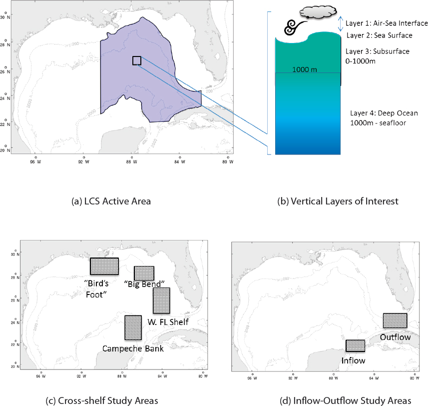
Within the LCS active area—an area roughly defined by the 200-meter isobaths on the Campeche Bank, West Florida Shelf and North Gulf Coast, 91° West, and Gulf areas west of the Texas/Mexico coast when an LCE is propagating westward, and by the areas of inflow and outflow (see Figure 3.1a)—the GRP should support a decade-long, vertically inclusive observational program (the campaign) that is adapted over time based on the positive impact on model skill, model suggestions, and emerging technologies,
as well as new theory. Specific gaps and recommendations within this region, from atmosphere to seafloor, follow.
Atmospheric Forcing
The impact of atmospheric forcing and extreme events is not well understood with today’s limited observations (e.g., Judt et al., 2016). While air–sea interaction at the surface may be an LCS behavior driver, the important missing piece is the integrated air–sea effect over the whole LCS area and beyond. Dynamic ocean forecast models will require forcing from atmospheric models, or in a more advanced case, the ocean and atmosphere evolve simultaneously via a coupled ocean-atmosphere model. In either case, spatially distributed validation data are required to ensure that the atmospheric model is on track, especially over water, where observations are less frequent. For instance, Mayer et al. (2017) demonstrated that model wind estimates are in high fidelity with observations at locations where the observations are assimilated, whereas the atmospheric model tends to underestimate the wind where the observations are not assimilated. This demonstrates that ocean weather forecasts are greatly improved when adequate observations are available for atmospheric model assimilation. Virtually all moored weather buoys in NOAA’s NDBC database and C-Man weather observing coastal towers are north of the U.S./Mexico exclusive economic zone (EEZ) delineation, as shown in Figure 2.3. There is one NDBC buoy in the central north Gulf of Campeche and one in the Caribbean Sea south of the Yucatan Channel. Observations
are lacking over a vast portion of the LCS region. The committee sees value in considering integrated air–sea effects in the LCS area. While surface drifters can carry SST, air temperature, wind, and air pressure sensors, they typically give the position only and are not deployed widely or at regular time intervals.
Recommendation 1: Additional instrumented surface drifters should be deployed when the LCS becomes active and throughout the LCS area to collect data on surface currents, SST, wind speed, air temperature, and air pressure at the air–sea interface. Regular, wide area deployment is desirable, as costs allow.
LCS Surface Mapping
The LC has been monitored by satellites for nearly 40 years. Altimeters provide along-track SSH and radiometric “imagers” provide maps of SST and ocean color. Current satellite altimetry and radiometric measurements, while not perfect in coverage, are the best long-term, near-real-time observations of the LCS area, even if they measure surface phenomena only. Deeper along-track T/S profiles are derived from surface satellite data and climatology, and do not provide true near-real-time hydrographic conditions in the upper 1,000 meters. The proposed SWOT altimeter can be expected to add value to scientific studies of the LCS (see Chapter 2 for details on SWOT).
Recommendation 2: Space-based altimeters providing critical SSH observations and space-based radiometers providing SST and ocean color should have their data assimilated into models and continue to be championed by the campaign team. Additional space-based instruments, such as the envisioned SWOT altimeter, are supported by the committee as evolutionary improvements to the science and near-real-time along-track surface observation set. This program is an important example of why continuing support for the U.S. array of Earth observing satellites is important for the U.S. government.
Satellite remote sensing data have been augmented with surface drifters to better define the LCS for more than 30 years. The drifters report their locations via satellite multiple times per day. They are sometimes equipped with simple sensors (e.g., ocean temperature). Drifters, like the ocean currents themselves, flow along fronts, so the objective is often to seed a feature of interest with drifters so that it can be tracked. Surface drifters have an extensive and proven industry-supported commercial history in the Gulf that requires confidentiality of the data to continue. Human analysis of satellite altimetry, satellite imagery, and surface drifters has documented an extensive data-derived history of LC path evolution and eddy shedding events.
Simple surface drifter buoys that transmit position are actively used when the LC is extended and when LCEs are forming and propagating to the west (though data are mostly proprietary), but more continual deployments over a wider area (before the LCS begins to threathen oil and gas operations) are missing for scientific analysis and assimilation into models. Furthermore, drifters outfitted with other sensors (e.g., SST, sea surface salinity, air temperature, air pressure) are not available in synoptic time frames. Deployment of additional surface drifters to fill this gap is included in Recommendation 1.
Internal, horizontal, and vertical interactions between the LC and an LCE, including formation, reattachment, eventual separation, and then propagation across the Gulf, are some of the most significant LC processes to correctly understand and model. A particularly important interaction is between the anticyclonic LCEs and the smaller, yet significant, cyclonic eddies that form along the edges of the anticyclone and exhibit a significant and observable surface expression. The eddies are often identified via government-supplied satellite remote sensing data, and are tracked with industry-sponsored surface drifters, as has been done for decades. HF radar (5 MHz) can sense ocean surface currents out to 150–200 kilometers from a transmitter/receiver site. They have been operational for several years as a part of IOOS, yet coverage is spotty, especially in the Gulf of Mexico (see Figure 2.2). There are no HF Radars near influential shoaling areas, in oil/gas operating areas, in LCS inflow/outflow regions, or where LCS currents and fronts might be observed and predictions validated.
Recommendation 3: In the near term, at least three multistatic HF radar systems should be procured and operated from fixed platforms in the oil/gas operations area to provide new, real-time data for model assimilation and validation, and to better understand the evolution of the LCS. The committee notes that NOAA will be procuring and operating HF radars in the south Louisiana “Bird’s Foot” area, and Texas has procured and committed to installing new HF radars along its coast. A recommendation in the Inflow/Outflow Recommendations section will be made to, in the near term, procure and/or install and operate HF radars to observe surface flows in the inflow/outflow areas (Yucatan Channel and Florida Straits). Should the HF radar recommendation above be acted on, in whole or in part, it will be important to collaborate with the nonprofit IOOS Regional Associations and with the NOAA IOOS HF radar DAC.
Subsurface LCS Dynamics
Subsurface data—from just below the surface to approximately 1,000 meters—within the general LCS active area are sporadic at best. Critical subsurface data on the vertical
density and velocity structure are usually missing. Thus, the vertical structure downward from the surface—the most energetic baroclinic mode—is rarely available in real time. This is a critical gap, because forecasting the evolution of the baroclinic structure of the LC and related instability leading to eddy shedding relative to observations will be an important metric for success. Continual subsurface vertical profile data are missing, but especially required, in “pinch points” where the extended LC narrows before creating and shedding an eddy or reattaching an eddy; in the cooler water transported from the West Florida Shelf when eddies do separate; in areas where the anticyclonic LCEs interact with the cyclonic eddies; and as the LC front moves north into the Gulf, potentially interacting with bathymetry. As mentioned above in the LCS Surface Mapping section, there are both horizontal and vertical interactions between the LC and an associated LCE’s behavior, but the subsurface observations necessary to fully describe and understand this complex process are missing.
Recommendation 4: The continually deployed vertical profiler fleet (e.g., Argo floats, 0–2,000 meters) in the Gulf should be doubled to approximately 40 floats; the new floats should be deployed in the LCS active area. This will enhance coverage to at least equal the global average envisioned for the Argo float array. As has been noted in Argo coverage statistics, this will not provide coverage in regions of strong boundary currents.
Recommendation 5: Approximately 20 gliders should be procured for operation in the LCS active area. This LCS glider fleet should be outfitted primarily to observe and report near-real-time currents, temperature, salinity, and 4D time and position for scientific analyses and assimilation into models. A benefit of the glider is that when it is at apogee near the surface, it transmits data observed in near real time and can receive course directions, for example, steering to cross the LC or penetrate an LCE. Both features are useful in observing this critical layer of the LCS. Additional sensors may be deployed on some gliders for shorter durations, depending on the scientific need. It is assumed that by obtaining a fleet of 20 gliders, approximately two-thirds of the gliders will be in the water at all times. The committee developed several scenarios adequately covering areas of interest with 12–16 gliders in operation. Collaboration with the IOOS glider DAC will be important.
See Recommendations 6 and 7 for additional recommended subsurface measurements.
Deep Ocean Dynamics
A relative blind spot in observations is mapping the currents, temperature, and pressure in the LCS active area from below approximately 1,000 meters to the bottom (as deep as about 4,000 meters). Deep ocean observations, however, are rare and sparse. A key field study (see Figure 2.8) was carried out under BOEM sponsorship for 30 months during June 2009–November 2011 (Lugo-Fernández and Hamilton, 2016), and several other deep observation field studies have been mounted in the last several decades. However, none of them lasted long enough to get sufficient seasonal, interannual, or LCS state change observations. It was not possible during those studies for a widely deployed and highly populated field of deep water instruments to report observations in near real time in an affordable manner. The recovered data were used by scientists to better understand the role of the deep ocean in LCS behaviors, and, as stressed above, the interaction between the deep barotropic layer with the baroclinic region above it; however, longer time series are clearly required to sample the variety of processes that affect different events. One can also consider a subset of deep instruments to be queried in a timelier manner. Neither a long-term array of deep instruments nor a near-real-time query program are/have been available. The BOEM field study mentioned above was highly regarded by the committee as a field campaign targeting LC dynamics; the committee found the bottom array of CPIES to be valuable, but sees greater value in extending a similar array of this general type to the north and west to cover a much longer period. Furthermore, deep abyssal eddies and TRWs are prevalent everywhere in the LCS. This leading mode of nearly depth-independent abyssal current variance has, with few exceptions, not been observed in the Gulf. It is thought that interactions between the upper baroclinic mode and the barotropic mode strongly influence their joint development, the evolution of the LC state, and the separation of LCEs. The energetic TRW and abyssal eddy currents and mapped pressure centers have typical horizontal wavelengths of approximately 50–200 kilometers and periods of about 10–100 days, so the mapping methods are geostrophic (Donohue et al., 2010; Firing et al., 2014).
Recommendation 6: A field array of bottom-mounted sensors that measure bottom pressure and integrated currents from near bottom to the surface should be procured and deployed for a decade, at laterally correlated, approximately 60-kilometer spacing in the LCS active area (25o–28o North Latitude, 85o–91o West Longitude). In the near term, deployments of 20–25 bottom-mounted instruments should be procured and deployed in a coherent subarray for process understanding and/or feature mapping in a critical region. This gets the long-term
observational effort started earlier and will inform the optimal spacing and locations for the eventual full array. In the technology recommendations section, the committee will address near-real-time query of the bottom-mounted instruments. Note that this effort would need to be coordinated with Mexican colleagues since several instruments could be deployed in the Mexican EEZ.
Moorings can be deployed to measure oceanographic features from the air–sea interface all the way to the bottom. The oil and gas industry is deploying some such moorings in the near term in 3,000 meters of water in the oil/gas operating areas (refer to Chapter 2); these will likely be able to sense nearby westward propagating LCEs. No mooring has been envisioned for the LC active area.
Recommendation 7: For the duration of the campaign, at least one mooring should be installed and operated in the central LCS active area (in at least 2,000 meters of depth, between 25o–28o North Latitude and 85o–89o West Longitude) to provide lower- and upper-layer observations of currents, temperatures, salinity, and air–sea surface interface data in real time for data assimilation, and to serve as a calibration reference for other deep instrument installations and vehicles/profilers working in the upper layer.
Inflow/Outflow
Gulf of Mexico regional-scale ocean forecast models are required to have boundary conditions for inflow and outflow supplied from a larger scale global- or basin-scale model. Multiple models are available, so important choices must be made and justified. LC inflow and outflow conditions are expected to have an impact on the evolution of the LCS inside the Gulf. The inflow/outflow connections to LCS state evolution (retracted-to-extended states) are not comprehensively observed at surface or at depth and hence are not well understood or sufficiently considered in model physical expressions. Modern uncertainty quantification methods were employed to quantify how uncertainties in the inflow from the Caribbean Sea affect the Gulf of Mexico fields (Thacker et al., 2012). The unanswered questions are not about the difference between the total volume in or out, but rather more about the variable horizontal and vertical structure of the inflow and outflow, and ensuring that at these control points, the LC in the forecast models have a reasonable structure with respect to the maximum velocities and the horizontal and vertical current shears. On the inflow side between the Yucatan and Cuba (western boundary), the upper water column flows mostly into the Gulf, but the bottom water can flow in either direction. Oceanographers have not been able to explain the onset and end of the underflow (Sheinbaum et al., 2002, 2016). On
the outflow side between the Florida Keys and Cuba/Bahamas, the flow is understood to be mostly eastward to the Atlantic, where the LC becomes the Gulf Stream. The outflow is intensified on the U.S. side of the Florida Straits.
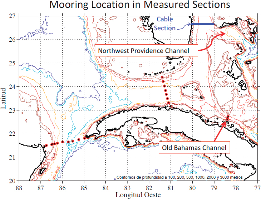
Measurements to understand the complexity of inflow and outflow in the Yucatan Channel and varying speed of the outflow in the Florida Straits have generally not been available for inclusion in LCS model physics. No vertical or horizontal current data are available for model assimilation in near real time. Some archived mooring data across the Florida Straits from Mexican academic observers have recently been made public by El Centro de Investigación Científica y de Educación Superior de Ensenada (CICESE).1 Data are included from July 2012 to the time this report was written, but it has not been fully analyzed. During the 2009–2011 BOEM-supported field study, a mooring array was positioned across the Mexican EEZ portion of the Yucatan Channel (moorings Y1–Y7 in Figure 2.5). The data acquired during the 2009–2011 BOEM experiment are available; however, data collected in the 2011–present time frame have not been made publicly available. Outside the scope of the BOEM study, the array shown in Figure 2.5 extends all the way to Cuba, with three additional moorings in Cuban waters (see Figure 3.2). These moorings are operated by CICESE and some aspects of the data have been published (Sheinbaum et al., 2016); however, the data have not been released to the public. The committee was briefed by CICESE that its mooring arrays (two arrays across the Campeche Bank, across the Yucatan Channel, and across the Florida Straits) will likely stop functioning in 2018 without securing new funding. One additional source of public data across the Yucatan is the 1999–2001 Yucatan Channel Experiment funded by the Deep Star Consortium. Mooring data aside, there are no continual measurements of surface LC speed for either control point.
Recommendation 8: Available Florida Straits data should be retrieved and used in outflow analysis. In the near term, the GRP should work with Mexican institutions on gaining access to data from the Yucatan Channel mooring array, as well as support for additional analysis. Furthermore, these recommendations can be undertaken by supporting a collaborating team of Mexican oceanographers or a joint U.S.–Mexico collaboration team.
Recommendation 9: The GRP should work closely with the appropriate Mexican institutions, in the near term, to keep the Yucatan Channel and Florida Straits mooring arrays operating beyond 2018 (for the next decade) with appropriate
___________________
1 At the time of report release, the data are publicly available at the following site: https://www.dropbox.com/sh/6wwwjfp3r5iae5x/AAA2PWnTmATpAeg3LhtRWlsoa?dl=0.
SOURCE: Julio Sheinbaum and Julio Candela.
data sharing; the Yucatan Channel array should take priority over the Florida Straits array.
Recommendation 10: HF radars should be procured and operated to provide new real-time data, in the near term, for model assimilation and validation and to better understand complex and variable surface outflow regions. Specific regions include:
- Elbow Cay, Bahamas, looking west at the oncoming outflow;
- In the lower Keys looking across the outflow; and
- In the Dry Tortugas, looking across the western beginning of the outflow and north into the general location where the LC interacts with the West Florida Shelf.
Collaboration with the IOOS Regional Associations and the NOAA IOOS HF radar DAC will be important in all such installations and their operations.
Recommendation 11: The GRP should advocate that Mexico install and operate at least two HF radar systems in the inflow area, one looking north (from the Cozumel Island area) and at least one looking across the inflow from the upper Yucatan Peninsula. If operational support is not available within Mexico, support for these radars and real-time sharing of their data output should be negotiated. Mexican colleagues, in their presentation to this committee, indicated that Mexico had procured several HF radars that are not installed or funded for operation. Should the HF radar recommendations above be acted on, in whole or in part, it will be important to collaborate with the nonprofit IOOS Regional Associations and with the NOAA IOOS DAC.
Interactions with Bathymetry
The LC interacts with the Campeche Bank soon after formation, and in its extended state, it interacts with the West Florida Shelf while heading south and east. An extended LC that reaches far to the north can interact with shoaling waters along the Gulf Coast, as can LCEs as they propagate west. Today, there are no mooring arrays along the LCS boundaries in U.S. waters that extend from shallow to deep depths, crossing the shelves from approximately 75–1,000 meters. There is increasing interest in the role that bathymetry plays in triggering LC extension and its role in generating TRWs that then interact with the LCS’s vertical structure. During the 2009–2011 BOEM-supported field study, in cooperation with Mexican colleagues, two mooring arrays were positioned across the Campeche Bank (moorings “N” and “E” in Figure 2.5). The Mexico-BOEM data were collected for 30 months and are publicly available. The moorings continue and will continue to be operated into 2018, but data collected in the 2011–present time frame have not been made available.
Recommendation 12: The data from the BOEM-Mexico project time frame should be analyzed specifically to better understand the effect of bathymetry on LCS behavior. Furthermore, in the near term, attempts should be made to access the data from these moorings from the 2011–present time period, and to negotiate terms to keep these mooring arrays in operation beyond 2018 (for the next decade). These recommendations can be undertaken by supporting a collaborating team of Mexican oceanographers or a joint U.S.–Mexico collaboration team.
LC observational programs have focused on the central portion of the Gulf of Mexico, where the LC and LC-related eddies (anticyclonic and cyclonic) tend to be located, along with regions of ongoing oil and gas operations. This has left the bounding
escarpment regions largely undersampled. By their support of TRW propagation, the escarpments provide an important avenue by which mechanical energy may radiate away from a region forced by either LC or LC-related eddy interactions.
The West Florida Shelf region was generally not targeted by prior BOEM studies because of the absence of oil and gas operations there. This fact, plus the physics of TRW propagation, makes this a suspected origination site and establishes the priority for moored observations across the West Florida Shelf and a real-time mooring at one point of transect (see Figures 3.1c and Figure 3.3). If resources permit, a long-term array west of Florida’s “Big Bend” and an array west of “Bird’s Foot” would increase understanding of the role that the Gulf’s northern boundary topography plays in LCS dynamics (see Figure 3.1c).
Recommendation 13: A linear array of four to six moorings should be deployed in the water column to observe temperature and currents in depths from 75 to 1,000 meters, on the southwestern extent of the West Florida Shelf, north of the Dry Tortugas. This moored array should be sustained for several years to cover the evolution of several LCS extension-relaxation cycles. See Figure 3.3 for the approximate location of the proposed mooring array.
Recommendation 14: Secondary to Recommendation 13, deploy a similar cross-shelf array (a) seaward of the Florida “Big Bend” along 28.5o North Latitude, and (b) west of the south Louisiana “Bird’s Foot.”
From an energetics perspective, a new, observationally based theory has been advanced, positing that the broad west Florida continental shelf may provide dissipation and buoyancy (when acted on by the LC in the southwest corner near the Dry Tortugas) that is sufficient for negating the ability of the LC to do work against the ambient Gulf of Mexico fluid, which is required for the LC to penetrate into the Gulf of Mexico (Weisberg and Liu, 2018). The testing of this new concept requires observations at a critical controlling region referred to as the pressure point (see Figure 3.3) by Liu and Weisberg (2016).
Recommendation 15: A single real-time mooring should be deployed, in the near term, at the “pressure point” (Liu et al., 2016), or at the shelf break region just to the northwest of the Dry Tortugas, to get the long-term observational effort started earlier and to confirm times regarding when the LC is driving the West Florida Shelf circulation, a phenomenon hypothesized to also be controlling the LC itself.
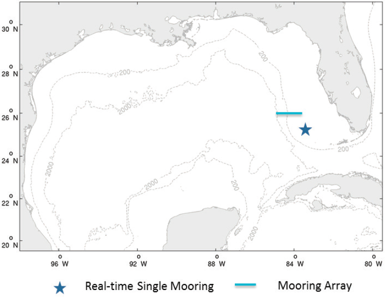
NOTE: The “star” indicates the “pressure point” mooring, and the line indicates the approximate location of the across-escarpment array with moorings at the 75-meter, 150-meter, 300-meter, 500-meter, 1,000-meter, and 2,000-meter isobaths.
TECHNOLOGY
Chapter 2 describes the state of sensors, moorings, and other underwater emplacements and vehicles that carry sensors commonly used in measuring currents in the Gulf. Generally, existing technologies can now measure the variables that scientists need to better understand LCS behavior. There are, however, several opportunities to advance technology that will make observing the LCS more efficient in terms of time and cost.
Scientists whose research is based on observations and aim to sort out the physics in the LCS’s behavior can rely on data collected and retrieved in non–real time. These scientists would then count on archival data for their analyses. Scientists whose research is based on modeling have different constraints. This program seeks not only to understand the LCS, but to provide improved predictions. To meet those goals,
near-real-time data are required so they can be assimilated into models which serve as the basis for the needed predictions. Sensors that observe the surface (e.g., satellite altimetry and radiometry, HF radar, surface drifters, ship and aircraft observations, moorings with surface expressions, USVs, gliders, and vertical profiling floats) can provide near-real-time data to scientists and modelers. Gliders and floats (Argo) have gathered some deeper 1,000- to 2,000-meter data. Some critical observing systems, especially those moored to the bottom, do not have a continual or intermittent surface expression, but there are archived data from their deployments in earlier field studies. Later, in Recommendation 22, the committee will discuss the value of a near-term desktop modeling study, during which deeper data from bottom-mounted PIES instruments, along with glider and float observations—data not currently assimilated in numerical models—can inform modelers about the impact of fully assimilated deep data and can therefore inform decisions about investments in near-real-time capture of deeper observations. The committee notes that NOAA’s tsunami warning array illustrates that bottom-mounted instruments can transfer data acoustically to a nearby mooring, which then telemeters the data ashore. However, for this effort, individual surface moorings for each subsea node might be too costly for the spatial coverage envisioned. Given that continuous data return is not required (as it is for the tsunami moorings), ASVs could be used to periodically transfer data from subsea nodes. Such a solution provides many advantages over fixed moorings: clear and flexible trade-offs between cost and update intervals, the ability to schedule more frequent updates when warranted by other observations, and the ability to avoid storm damage. While there have been initial demonstrations with purpose-built ASVs combined with acoustic modems that have shown the technical viability of subsea-to-surface acoustic data transmission capability, these are not widely used. The committee believes that adding the capability to communicate the data (or have their data retrieved) in near-real-time in a reasonably affordable manner would benefit modeling and predictive skill. This capability would also allow scientists to identify malfunctioning sensors in a timely manner.
Recommendation 16: In the near term, a team of scientists and engineers familiar with acoustic data communication networks should be supported to determine the feasibility of designing (and, if feasible, building) an acoustic data communication network that might be adopted by bottom-moored arrays and provide near-real-time data to the surface in an affordable manner, considering the specific acoustic environment in the LCS campaign area.
Recommendation 17: As funding may allow, a demonstration of near-real-time data collection from deep instruments using ASVs, or similar technologies,-
should be discussed, and, if funded, the data should be assimilated to inform their value to model skill.
Long-range HF radar (5 MHz) has proven effective in observing surface currents within approximately 150–200 kilometers of a transmitter/receiver site. In the case of the LCS, if installed, HF radar can cover the inflow and outflow areas from land-based HF radar sites (Recommendation 10) and LCE propogation from fixed platforms in the oil and gas operating area (Recommendation 3). There is typically no HF radar coverage beyond 200 kilometers from shore during nonstorm conditions, but if that were possible, scientists and modelers would be better able to observe the LCS extended state, LCE formation, and LCE propagation. HF radar coverage “at sea” would help in the validation of LCS model skill as well.
Recommendation 18: The GRP-supported campaign should demonstrate sustained operation of HF radars mounted on moored buoys or other platforms in the Gulf from which there can be reliable communication to shore.
A key gap in LCS understanding and observations, as mentioned earlier, is observations in the baroclinic layer of the LCS area (ranging from the surface to about 1,000 meters). While autonomous vehicles (gliders, profilers, and AUVs) can meet many of the recommendations listed in this report and can gather useful data at their specified mobility rates, the committee envisions evolving needs for more capable and bigger vehicles that might carry larger payloads and provide the requisite power for longer operational duration, higher speed, or an ability to maneuver more quickly to capture data during a rapidly changing LCS event. Another potential benefit to future glider operations is on-board path-planning algorithms to better execute desired trajectories in the face of challenging, dynamic conditions. Over the ensuing decade, hybrid gliders (combining the attributes of a glider and an AUV) can contribute to an enhanced glider fleet, especially if improved energy sources become available.
Recommendation 19: The GRP-supported campaign should be open to adopting new technologies (e.g., larger gliders, hybrid gliders, new power sources, new guidance algorithms, shore launch and retrieval, and emerging long-endurance AUVs) in its sensing fleet as the campaign matures.
The committee received briefings and had discussions with successful glider operators and sees their value principally in upper-layer observation. The committee also discussed the uneven reliability of gliders, due to design flaws, uneven maintenance, or inadequate system operator skill/training. Glider reliability is an important consideration when procuring a glider fleet and deciding who will maintain and operate the gliders. The committee recognizes that gliders can be very effective when adequate
funding is available for supporting well-trained staff and ensuring adequate equipment maintenance.
Recommendation 20: The GRP should advocate with funding agencies, inside and outside of governments, for the creation of a national glider training syllabus and certification program. Finally, the committee recommends that all glider operations in the LCS campaign use the NOAA IOOS-developed “glider DAC” protocols.
DATA ASSIMILATION AND NUMERICAL MODELING
Due either to the lack of data, or lack of long-term data, the physics involved in LCS behavior is not fully understood; hence, it may not be completely included in models’ physical expressions. As identified in Box 3.2, inflow/outflow complexities may not be in all models; neither will the interactions between the surface and subsurface (baroclinic and barotropic) layers, and between cyclonic and anticyclonic eddies, nor LC interactions with bathymetry, nor current model physics’ consideration of the full range of near surface air–sea interactions in the LCS area, among others. In addition, there is a range of models available and each may treat these relatively unconstrained processes differently. As the data observation situation is enriched in the next decade, new model physics and data assimilation modules will need to be included in the model package, and the approaches of different models will need to be assessed. Some appropriate “process” experiments can be designed to further refine theory and quantify relative contributions of the various forcing/mechanisms leading to the variability of the LCS. The relaxation of the hydrostatic constraint in some processes that involve small-scale jets and mixing may be necessary.
As the LCS active area campaign develops and as other recommendations on bathymetric interaction and inflow/outflow complexities are addressed, there will be a general need to incorporate new physics into the models, assimilate newly acquired
near-real-time data, adopt the most recent data assimilation methodology and long-range statistical modeling approach, and conduct process studies wherein observational scientists and numerical modelers focus on the importance of certain processes discovered and described as a result of more robust observations. These will come in time as observations flow and new understanding is gained and transformed into model physics equations.
Recommendation 21: Data assimilation and modeling experts should be brought into the program at the onset of the campaign. Transfer of knowledge between observational scientists, scientific analysts, theoreticians, and the modeling community will be important to the success of this campaign.
In addition to gaining a better understanding of and then checking the processes outlined above, models should also be intercompared for their skill in reproducing an observed time series. This requires hindcast studies and thorough skill assessments, a necessary step for achieving more accurate forecasts. In 2010, a 2-year program called GOMEX-PPP was funded to compare SSH prediction accuracy among the many advanced numerical models. Models have advanced further, and the metric for success that the committee sees as important has changed as well (viz., current velocity in the oil/gas operation region is the first/near-term priority). We also note that using models in real time to guide the ocean observing campaigns would be most useful. Conversely, the new observations can be utilized to calibrate models and to improve the model parameterizations in real time.
During the period of June 2014–December 2015, surface observations of the LCS showed a high level of activity: an extended LC with various LCE sheddings, reattachments, and propagations. At the same time, a greater number of Gulf short-term field study observations were made under the GoMRI program and by industry-supported drifter deployments. The set of observations during this period of high LCS activity has not been fully analyzed with LCS behavior in mind.
Recommendation 22: A new skill assessment among existing Gulf prediction systems should be completed in the near term to test current model performance in resolving both surface and subsurface circulation, to test long-range prediction capabilities, and to better inform the campaign’s final design. This is a critical first step in that it will influence final campaign decisions on instrument selection, instrument deployment schemes, and investments in near-real-time data recovery and assimilation. As discussed in Recommendations 16 and 17, this desktop study should pay special attention to the assimilation of deep observations, noting their impact on model skill and value if provided in near real time. Furthermore, such analyses can inform decisions on the value of near-real-time deep, but not bottom-mounted, instruments (e.g., deep gliders and Argo
floats) versus bottom-mounted pressure/current instruments, and the complementarity if both types of instruments can transmit their data in near real time. The effort should have the participation of existing Gulf-scale data assimilative prediction systems that are based on three leading community ocean models (HYCOM, MITgcm, ROMS) and consist of three phases:
-
Phase I of the project will include a retrospective nowcast (i.e., hindcast) of the Gulf of Mexico circulation for two focus periods: (1) 2009–2011, when the BOEM-sponsored deep observations are available; and (2) 2014–2015, when the LCS was hyperactive, in which various LCE sheddings, reattachments, and propagations occurred.
Each modeling system will be tasked to use its latest models and data assimilation schemes to assimilate observations (e.g., BOEM deep observations in 2009–2012, along with other publicly available surface observations such as satellite SSH, SST) to produce its best data assimilative hindcast of the Gulf circulation in 2009–2011 and 2014–2015, respectively.
Solutions from each model will be compared against independent observations (i.e., data that are not assimilated into the models [e.g., ship observations, industry ADCP and/or drifter data]) for skill assessment and intermodel comparisons.
The evaluation of these best data assimilative hindcasts will also lead to an important consensus scenario of circulation conditions that occurred in the Gulf during 2009–2011 and 2014–2015. Next, process analyses will be pursed using these hindcasts to depict the time-space evolutions of the LCS and the underlying mechanisms that triggered LCE shedding, reattachment, and propagation.
-
Phase II of the project includes a restrospective forecast for 2009–2010 and understanding the added values of deep observations. Each modeling system will be tasked to perform a retrospective 3-month forecast at 1-month intervals for 2009–2010. They are allowed to assimilate “past and current” surface and BOEM deep observations before making each sequential forecast.
Skill assessment and intermodel comparisons will be performed against not-yet-assimilated data in the corresponding forecast window. The goal here is to assess and document skills of the current state of models in forecasting the Gulf circulation over time scales ranging from days to months with observations from both the surface and subsurface.
Back in 2011, the GOMEX-PPP project did a similar retrospective forecast experiment, but with the assimilation of surface data only. This new effort will provide
-
an update on models’ forecasting capabilities 8 years later, and provide an understanding of the added value of assimilating deep observations.
Results from the study also serve as the baseline to evaluate future model development and skill improvement.
- In Phase III of the project, each modeling system will be tasked to perform Observing System Simulation Experiments (OSSEs) to quantitatively assess the values of different ocean observing system components to forecast. The goal of the OSSE is to measure the impact of several designated observing system components (e.g., radar, moorings, gliders) over model prediction. Ensembles from multimodel OSSE experiments are the expected outcome, and they will be used to provide references on observational design criteria, instrumentation locations, and sampling intervals before the start of the campaign.
For accurate long-term simulations, due to the multiple scales and region-dependent dynamics in the Gulf, model resolutions need to be refined in regions with larger dynamic gradients, steep topography, or complex bathymetry/coastlines. Tiling and nesting schemes use finer resolutions in targeted regions (Debreu and Blayo, 2008; Debreu et al., 2012; Haley and Lermusiaux, 2010; Haley et al., 2015; Ringler et al., 2013), while unstructured grids increase the mesh resolution progressively where needed within the same modeling framework (Deleersnijder and Lermusiaux, 2008; Deleersnijder et al., 2010; Ringler et al., 2013). New techniques that use different equations depending on the dynamic needs (e.g., nonhydrostatic only where needed) are also promising. Nesting schemes have been utilized in the Gulf (e.g., Barth et al., 2008; Oey et al., 2005a; Prasad and Hogan, 2007; Zamudio and Hogan, 2008). Other numerical modeling research includes efficient schemes for air-sea-wave coupling to accurately represent the one-way forcing and two-way interactions of the atmosphere with the ocean. Similarly, improved mixing and diffusion parameterizations are needed for lateral and bottom boundary layer dynamics, and for the energy and vorticity cascading across different scales.
The assimilation of altimeter data in some LCS models relies on climatology-based synthetic T/S profiles that may deviate significantly from the real state, especially when energetic deep eddies perturb SSH and the LCS is active. Sensitivities to the different climatological profiles used to assimilate the altimeter data are only beginning to be investigated. More work is required to establish the impact of new methodologies on the forecasts.
Closely connected with hindcasts and forecasts are data assimilation models that assimilate observations from satellite and some in situ observations. Most of the
existing data assimilative models for the Gulf have not been thoroughly documented or adequately tested against independent observations. Existing data assimilation methods (e.g., Edwards et al., 2015; Lermusiaux et al., 2006b) include using a simple optimal interpolation method (Daley, 1991) to directly assimilate satellite SSH anomalies (Mellor and Ezer, 1991) or assimilate synthetic temperature and salinity fields derived from a surface-subsurface correlation based on SSH anomalies (e.g., Oey et al., 2005b). More sophisticated assimilation techniques, such as 3DVar, and especially 4DVar with the “adjoint” model, exist, but not in every model. The “adjoint” techniques (e.g., Chen and He, 2015; Chen et al., 2014; Li et al., 2015; Moore et al., 2009; Thacker and Long, 1988; Zeng and He, 2016) are particularly powerful methods used not only for hindcasts and forecasts, but also for linearized sensitivity analyses that can help with observing system designs. These analyses, in conjunction with OSSE (Halliwell et al., 2015), can provide valuable insights into physical processes and dynamics. Complementary to adjoint-based schemes are ensemble data assimilation methods (e.g., Evensen, 2003; Lermusiaux, 2007) that have also had successes in the Gulf region (e.g., Counillon and Bertino, 2009; Hoteit et al., 2013; Jacobs et al., 2014; Wei et al., 2016; Xu et al., 2013). Such Monte Carlo schemes run an ensemble of simulations with perturbed initial conditions, boundary conditions, and/or stochastic forcing (Lermusiaux, 2006, 2007; Lermusiaux et al., 2006b). The resulting nonlinear quantification of uncertainty provides probabilistic forecasts that are useful for theoretical variability studies and for practical applications and risk analyses. Related to ensemble approaches are polynomial chaos schemes that also allow for nonlinear sensitivity studies (Thacker et al., 2012). Recently, differential equations have been derived for efficient reduced-order predictions of uncertainties in nonlinear fluid and ocean systems (Feppon and Lermusiaux, 2018; Sapsis and Lermusiaux, 2009; Ueckermann et al., 2013). Such methods reduce the cost of direct Monte Carlo ensemble schemes by orders of magnitude. They also allow for nonlinear estimations of predictability limits and are useful for quantifying the predictive capabilities of modeling systems.
Given the number of observations in the Gulf, it is critical to best utilize the observations that are collected. First, accurate multivariate and global data assimilation schemes should be used to correct one field or one location from the measurements of another field or location, without the need for ad hoc or artificial extensions. Both adjoint-based and ensemble-based schemes can complete such corrections. This capability is, for example, most useful to update deep properties from surface measurements. Second, targeted or adaptive observations (Leonard et al., 2007; Lermusiaux et al., 2017; Robinson and Glenn, 1999) (i.e., the prediction of the most informative observations to be collected) should be investigated. Such adaptive data collection (adaptive sampling) will be most useful for increasing the predictive capabilities of current
modeling systems from short- to long-term LC forecasts. With adaptive sampling, one can, for example, forecast the observations that are most informative to estimate the future fields of interest, such as the LC state. It can also identify the observations that best discriminate among competing model parameterizations or best-estimate parameters. Finally, the use of principled Bayesian inference to perform all of the above accurately, possibly in full non-Gaussian ways, needs to be investigated for the Gulf of Mexico regions.
Recommendation 23: Modeling tasks funded under the GRP should be given the latitude and encouraged to adopt new methods as they mature. New efforts in numerical ocean modeling will likely improve modeling skill over the period of interest. For the oil and gas applications, research should also emphasize long-range (within a time scale of up to 3 months) forecasts of the likelihood of specific events.
As new sources of data become available in near real time and as models attempt to assimilate those new data, there will be a new burden on computational capacity. This is likely to be unaffordable to a nongovernmental program like the GRP or any private modeler. Collaborations between national research laboratories (e.g., Naval Research Lab [NRL], National Center for Atmospheric Research [NCAR], Geophysical Fluid Dynamics Laboratory [GFDL], the Naval Oceanographic Office [NAVOCEANO], National Center for Environmental Prediction [NCEP]) and universities are likely to be most beneficial. It should be noted that the GRP’s funding authorities do not allow for the funding of federal activities.
Recommendation 24: The GRP should actively solicit cost sharing or other computer center collaborations to ensure that the results of the campaign can be supported continually and operationally.
So far, most of the modeling efforts for the LCS use primitive equation ocean models. Recent developments in statistical modeling based on machine learning have shown promising potential in offering credible long-range LC and LCE separation forecasts. Applications of machine learning methods have demonstrated successes in predicting many other nonlinear natural processes such as El Niño. Their full potential for use in Gulf LCS prediction still needs to be determined. Combinations of previous governing-equation-based modeling with machine learning schemes also have potential (e.g., Lermusiaux et al., 2016, 2017; Zeng et al., 2015a,b). Predicting the LCS deterministically can sometimes be as if doctors were providing a single forecast of the result of a single possible treatment, without using the concepts of risks or of the different initial conditions, that is, each patient. It would also be as if doctors were deciding to not utilize machine learning and big data or other new emerging approaches to help them in their work and possibly increase the number of lives they can save. Of course, a big
difference in ocean prediction is that governing equations are relatively well known; however, many parameterizations, initial and boundary conditions, and forcing mechanisms are uncertain, and additionally, there are numerical and human errors. Hence, it appears essential to account for varied possible outcomes, for uncertainties, and for risks to the oil and gas activities and platforms. This is especially true for the mid-to long-range (a few months and beyond) forecasts where uncertainties cannot be ignored—stochastic approaches are then most useful. There is also some justification for a fully statistical approach (e.g., without a use of deterministic governing equations) and for machine learning because these approaches have been useful in varied settings (Hsieh, 2009; Storch and Zwiers, 2002) and can be used for the LCS problem (Zeng et al., 2015a,b).
Recommendation 25: The GRP campaign should encourage the development and testing of the statistical and stochastic modeling approach, especially for the mid- to long-range (a few months and beyond) prediction of the LCS.
Recommendation 26: Numerical modelers should be consulted in developing the specific observational programs’ design, and that “adaptive sampling,” based on model results, be continually practiced throughout the campaign, especially for those observational subprograms that have a choice in timing, areas of deployment, and vertical/horizontal spacing. Within 3 years of the commencement of the campaign, the impact of the new observations and new understanding of the LCS model should start to be presented and reviewed.
ANALYSES AND THEORY
It is important to note that many have studied the LCS over the past several decades. However, several critical gaps in understanding remain—a compilation of data from such studies would provide a useful tool for scientists to consult over the next decade. Each discrete “field study” had theory in mind when it was designed. Yet understanding, and, hence, predictive skill, have not advanced sufficiently to improve LCS forecasts beyond a few days (with the exception of times when the LCS is stable), even when existing data streams are available. The committee sees catalytic value in a set of comprehensive campaigns that will bring new and long-term observations ashore for scientific analysis and assimilation into improved models. During this period, as a result of the new observational wealth, new theories will emerge.
Recommendation 27: In the near term, the GRP should support a desktop-style study to digitally compile (and make publicly accessible) physical oceanographic data from Gulf of Mexico field studies carried out between 2002 and 2018. The
last database of observations was compiled during the MMS-sponsored “Deepwater Physical Oceanography Reanalysis and Synthesis of Historical Data Study” (Nowlin et al., 2001), which covered the time period from 1990 to 2001. Extending this compilation through 2018 will create a ready digital reference for the many field and theoretical scientists who will likely be supported in future LC observational and analytical studies.
Recommendation 28: Science teams should be engaged early in the campaign process and campaign leaders should encourage focused process studies and the testing of new theories.
METRICS OF SUCCESS
There are two main parts to the campaign effort: the first is to use new observations to better understand the science, or dynamics, associated with the LCS; the second part and ultimate goal of the campaign is to use both the observations and the new scientific understanding to improve models of the LCS and thus increase predictive skill of LCS activity.
The first measure of success hinges on advances in our understanding of the dynamics driving the LCS. If efforts put forth by this campaign through new observations, technology, analyses, and modeling lead to a better understanding of what controls the penetration of the LC in the Gulf of Mexico, and/or what determines the shedding of an anticyclonic eddy, then the campaign will have succeeded in filling important gaps in the scientific understanding of the LCS.
With the ultimate goal of applying the new understanding to more accurately predict LCS activity, quantitative metrics of success are also required. These metrics must be both measurable from observations and predictable by models. A few past efforts at forecasting ocean conditions in the Gulf have focused on metrics of SSH, a variable that is measured effectively by satellite. State variables in the ocean include velocity, temperature, salinity, and density, all of which are functions of latitude, longitude, depth, and time. A practical metric for forecast evaluation will allow for the calculation of statistics over a defined volume and at a specific forecast lead time. For example, forecasts of days to 1 week, 1 month (some refer to this period as “subseasonal”), and 3 months (some refer to this period as “seasonal”) are sensible targets. Spatial extents are as large as the entire Gulf for long-term forecasts of 1 to 3 months, and as small as the operational region of the northern Gulf at times of days to weeks. The processes that must be observed and modeled include the extension of the LC into the Gulf, the separation of an LCE, and the propagation of the eddy northward and westward across the Gulf. Skill at forecasting these processes can be appropriately quantified
through metrics of velocity (e.g., feature-based tracking and overall velocity distribution statistics), whose measurement will be a focus, and frontal placement.
Recommendation 29: By the close of this project, success should be measured by the ability to predict currents (including uncertainty) in the LCS active area (see Figure 3.1) and in areas where the LCEs propagate. The committee recommends a hierarchy of forecast periods, matched to the relevant processes and regions of interest:
- Improved predictive skill in forecasting the LC and/or LCE current speed, vertical structure, and duration in the oil/gas operating area out to a forecast period of days to 1 week
- Improved predictive skill in forecasting the extension of the LC (location and duration) and LCE propagation out to a forecast period of approximately 1 month
- Improved predictive skill in forecasting an eddy shedding event from an extended LC out to a forecast period of approximately 3 months
This page intentionally left blank.


