
CHAPTER 4
Natural Hazards
Natural hazards drive concerns for risk management in the Spirit Lake and Toutle River system. This chapter summarizes these hazards, discusses the state of knowledge about them, and considers how they integrate within a decision framework. The understanding of these natural hazards, their probabilities of occurring, and their potential magnitude is the foundation for risk management in the region. The literature concerning the hazards is large. The recent report by Grant et al. (2016a) surveys that literature.
Following the 1980 eruption, the initial and pressing concern was the possibility that Spirit Lake might breach its debris blockage and create a cataclysmic, sediment-laden flood in the Toutle River valley and the Cowlitz River plain. This possibility was much in the minds of cognizant agencies and of affected parties. Geologic evidence from ancient eruptions led to the reasonable belief that a breakout flood was possible and with precedence in the geologic record (e.g., Scott and Janda, 1982). The consequences of a breakout flood could be enormous. Furthermore, engineering calculations at the time supported the geologic record, confirming the extent of inundation and the depth of sediment deposition that might be expected from a breakout flood (Swift and Kresch, 1983).
Today, the initial concern over a breakout flood has partially abated given the 35-year history of successful management of Spirit Lake drainage. At least three natural hazards need to be considered, however, in the management of the Spirit Lake and Toutle River system. For these to be explicitly considered in a decision framework (see Chapters 6-8), three issues present themselves:
- The set of hazards that potentially affect the system and lead to downstream effects;
- The annual probability of each hazard and its severity; and
- The potential downstream consequences should a hazard event occur.
The probability of a given hazard affecting the system increases as the time frame of consideration grows longer. Processes with low annual probabilities, but possibly large impacts, become increasingly likely as the planning time frame grows longer. Thus, it is important to define the time frame early in the decision-making process because it affects planning. A great deal of data collection and analysis was performed in the early years following the 1980 eruption. These investigations have continued, but less intensively, and a number of uncertainties remain. Some of these affect risk management and the decision-making framework, as discussed in Chapters 6-8.
Three sources of natural hazards that affect management of the Spirit Lake and Toutle River system are discussed in this chapter as well as the hazards that affect management of the Spirit Lake tunnel and the sediment retention structure (SRS). These are meteorological, volcanic, and seismic. These three could result in or exacerbate any issues related to the management of sediment and water transport in the Spirit Lake and Toutle River system; thus, their probabilities and impacts need to be thoroughly understood to make wise management decisions. Two other natural hazards are considered in the Cowlitz County Hazards Mitigation Plan: landslides and wildfire (Cowlitz County Department of Emergency Management, 2013). Each is of importance as it may affect sediment delivery, runoff, and nutrients. This report, however, focuses on meteorological, volcanic, and seismic hazards because of the greater likelihood of their region-wide impacts. Moreover, because of the 1980 eruption’s effect on the location and availability of fuels in the upper Toutle River, fire is not as much of an issue and will not be for some time (USDA Forest Service, 1997).
The first part of this chapter summarizes the natural hazards, risks, and state of understanding associated with meteorological, volcanic, and
seismic events and a summary of our understanding of the debris blockage and the catastrophic flooding that could occur as a result of its failure. The adequacy of information related to all these topics is described. The text continues with a discussion of how hazards can be integrated using probabilistic hazard assessments and how a probabilistic assessment fits into a decision framework. Information needs are also discussed. The chapter concludes with a brief discussion related to ongoing monitoring.
METEOROLOGICAL INPUT AND CHRONIC FLOODING
As has been discussed earlier in this report, the Toutle River valley and lower Cowlitz River plain are subject to both chronic and catastrophic flooding. Chronic flooding—the severity of which is affected by a combination of meteorological inputs (e.g., rainfall, rain-on-snow events), sediments already in the system, and management of those sediments—results from the normal hydrological regime. Precipitation falling on the Toutle River basin is large enough to generate large river discharges. Average annual precipitation varies from approximately 50 inches (127 cm) at Castle Rock, elevation 60 feet (20 m), to approximately 120 inches (305 cm) at Mount St. Helens and Spirit Lake, elevation 3,400 feet (1,036 m), averaging about 75 inches (190 cm) over the entire basin (West Consultants, 2002). The U.S. Army Corps of Engineers’ (USACE’s) flood risk management (FRM) in the Toutle River and Cowlitz River areas addresses chronic flooding. This includes the SRS as well as the extensive system of levees in the lower Cowlitz River plain and intermittent dredging.
More important in the context of chronic flood generation is the precipitation that falls during the wettest years and the combination of warm precipitation on snow, which may accompany those larger storms. Thus, an important determinant of flood potential is the accumulation of water stored in snowpacks. Based on data collected at snow courses in the vicinity of Mount St. Helens, Dunne and Leopold (1981) found that median snow water equivalents on April 1 ranged from 47 inches (120 cm) at an elevation of 3,510 feet (1,070 m) to 118 inches (300 cm) at an elevation of 6,100 feet (1,860 m). In extreme years the maximum storage can rise to as
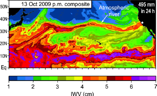
much as 79 inches (200 cm) at lower elevations and 157 inches (400 cm) at higher elevations. Snow depths are subject to rapid melting during warm rainstorms—events known as atmospheric rivers and often referred to as the “Pineapple Express” (see Figure 4.1). As an important flood generation mechanism in the coastal American West, these narrow zones of the atmosphere transport large volumes of warm, moist air from the subtropics over the mountainous watersheds of the Pacific coast, generating heavy rain accompanied by rapid snowmelt.
The post-eruption condition of the Toutle River valley has another important effect on flood hazard in the settled parts of the Toutle River and lower Cowlitz River valleys, namely, as a source of sediment that can settle in the Cowlitz channel and reduce the flood conveyance capacity of the engineered levee system between Castle Rock and the Columbia River confluence (see Figure 4.2). The USACE has periodically dredged these river reaches for the purposes of flood risk management. As has been described earlier, a principal rationale for the construction of the SRS was to retain this sediment load higher in the Toutle River basin.
Effect of Changing Climate
Changing global climate adds uncertainty in assessments of flood hazards in this region. An increase in the frequency of flood-generating weather events is likely. While projected changes in precipitation are small, temperatures are projected to increase through the end of the century, leading to a transition of snow to rain and more flooding (Mote and Salathé, 2010). Seasonal cycles responsible for heavy precipitation are also projected to
intensify. The expected warming atmosphere will increase atmospheric water vapor, which is projected to increase the frequency of days the most extreme atmospheric rivers are generated by up to 290% by 2100 (Warner et al., 2014).
Impacts of Chronic Floods
The area potentially at risk from chronic flooding extends north from the confluence of the Columbia and Cowlitz Rivers and east along the Toutle River to the confluence of the North Fork Toutle and Green Rivers. The lower reaches of the Cowlitz River include the cities of Castle Rock, Lexington, Kelso, and Longview, Washington, before entering the Columbia River. The area at risk also includes approximately 1.25 miles (2 km) of the Columbia River extending from its confluence with the Cowlitz River to the Columbia River navigation channel.
Populated areas in the region are primarily in Cowlitz County. Managed areas along the Cowlitz River include portions of Longview, Kelso, Lexington, and Castle Rock, with a total population of approximately 50,000 (see Table 4.1). Property in the leveed areas has a value of approximately $3.65 billion (USACE, 2014).
Adequacy of Existing Information
The current level of information on chronic flood hazard in the Toutle and Cowlitz Rivers and on the management of flood risks is similar to that in most river basins managed by the USACE (see Table 4.2). There is uncertainty, however, about the importance of changing climate on the hydrology of the system and its effects on chronic flooding. This uncertainty is likely to be similar to that in other flood-managed basins across the country.
One characteristic of the Toutle River system that makes it unique is the existence of the SRS and the sediments stored behind it. A large magnitude earthquake could change the behavior of the sediments behind the SRS (e.g., as a result of earthquake-induced liquefaction) and change the
TABLE 4.1 Inventory of Levees and Authorized Levels of Protection in the Cowlitz River Plain and Corresponding Annual Probabilities of Floods Exceeding the Level of Protection (LOP)
| Levee Location | Owner | Authorized LOP (yrs)a | Annual Exceedance Probability of Floodinga | Length (miles)b | 2010 City Populationc |
|---|---|---|---|---|---|
| Castle Rock | City of Castle Rock | 118 | 0.0085 | 1.5 | 2,140 |
| Lexington | Lexington Flood Control Zone District of Cowlitz County | 167 | 0.006 | 2.7 | NA |
| Kelso | Cowlitz County Consolidated Diking Improvement District No. 3 and the Drainage Improvement District No. 1 | 143 | 0.007 | 5.7 | 11,925 |
| Longview | Cowlitz County Consolidated Diking Improvement District No. 1 | 167 | 0.006 | 2.4 | 36,648 |
aData from USACE, 2009.
bData from USACE, 2010b.
cU.S. Census Bureau. Settlement of Lexington is not included as an entity in the U.S. Census.
TABLE 4.2 Existing Natural Hazards Information on Chronic Flooding
| Existing information | Annual probabilities of fluvial flooding; estimates of impacts from chronic flooding; estimates of sediment yields; assessments of levels of flood protection provided by the levee system. |
| Strengths | Historical data on flood frequencies and severity in the system are reasonably complete. These assessments follow normal USACE practice for FRM. |
| Weaknesses | Uncertainty in sediment yields into the Toutle River; some uncertainties regarding impacts of climate change and possibly regarding the impacts of large seismic events on releases from the SRS. |
SOURCES: Dunne and Fairchild, 1984; Lombard, 1986; USACE, 2009, 2010a,c.
probability of chronic flooding should a large meteorological event occur. The simultaneous occurrence of a large magnitude earthquake and a large meteorological event is less probable than either event occurring singly, but simultaneous occurrence could result in greater changes in sediment behavior.
VOLCANIC HAZARDS
The geologic setting of the region, including volcanism, is described in Chapter 2. Consideration of volcanic activity in a decision framework has two main components: (1) defining hazards that affect the Spirit Lake and Toutle River system resulting in downstream impacts and (2) defining the annual probability of each. Individual volcanic eruptions can produce multiple hazards processes or types. Some volcanic processes associated with certain types of eruptions may not affect the Spirit Lake and Toutle River system and thus can be ignored. For example, dome building activity similar to the 2004-2008 episode may have no effect on that watershed, and it may not need to be addressed in detail.
Volcanic activity can produce several hazards, each with unique physical impacts on the Spirit Lake and Toutle River watershed and infrastruc-
ture within. These may extend downstream as far as the SRS and well beyond. The emphasis here in this discussion is on hazards that could affect management decisions regarding the Spirit Lake drainage and the SRS. The list appears generic in that Mount St. Helens is capable of producing the full range of volcanic hazards. These hazards include
- Tephra fallout, which are deposits produced by direct fallout of particles (e.g., pumice, ash, lithics) from a high-standing volcanic plume ~10-20 miles (~15-30 km). Such deposits blanket the landscape in the downwind direction during an eruption. In the case of the Spirit Lake and Toutle River system, impacts could include choking of the Spirit Lake tunnel intake with pumice floating in the lake and introduction of abundant loose material onto parts of the watershed, which can be remobilized rapidly by surface water flow and dramatically increase the sediment flux to the SRS.
- Pyroclastic flows, which are very hot ash, lava fragments, and gases that are explosively ejected from the volcano, typically at high speeds. They are more limited in extent than tephra fallout are and would most likely form a new fan of unconsolidated deposits on the pumice plain (see Figure 2.7). Some might reach and directly introduce material into Spirit Lake, but assuming no major topographic changes in the area, most would likely contribute to increased sediment flux into the Toutle River and the SRS if flow deposits are remobilized in tributaries of the North Fork Toutle River by alluvial or fluvial processes. Pyroclastic flows could rapidly melt snow from the crater and the pumice plain and evolve into a lahar of a magnitude that could arrive at the sediment plain upstream from the SRS (Denlinger, 2011).
- Lava flows produced by Mount St. Helens during recent eruptive episodes mostly have involved highly viscous magma that formed domes around the vent and flowed only a few hundred meters, as, for instance, during the 2004-2008 eruptive episode. Such lava domes may experience partial collapse, however, which can produce small pyroclastic flows. If basaltic lavas, which are hotter and
-
less viscous, were to be erupted, however, they could flow several kilometers.1 Because basaltic lava flows are strongly controlled by the lowest paths across the topography, it is unlikely that one would reach Spirit Lake. Nevertheless, such a flow could disrupt drainages in the pumice plain that feed the Toutle River. Lava flows can also cause rapid snowmelt that in turn can trigger lahars.
- Volcanogenic lahars (volcanic mudflows) could result from emplacement of new tephra fallout, pyroclastic flow, lava flow, or debris avalanche deposits. Materials deposited by these processes can then be remobilized by heavy precipitation or can induce rapid melting of snow and ice, providing water for the flows. Lahars could introduce large volumes of sediment into the SRS. There may also be lahars that are not triggered by volcanic activity, but these are more appropriately thought of as flood or geotechnical hazards.
- Debris avalanches in the Toutle River valley are unlikely until the volcano rebuilds itself from the 1980 sector collapse. Their probability, then, depends upon the time frame of interest. Such flows could introduce large volumes of debris into the Toutle River system.
For any given eruption scenario, annual exceedance probabilities can be defined—and the uncertainty of those probabilities—for the aforementioned hazards and their impacts to the Spirit Lake and Toutle River system. The information can also be used as input for design criteria for any new mitigation structures and as input to a decision-making framework such as the one presented in Chapters 6-8 of this report.
The Probability of Eruptive Events
Table 4.3 summarizes the estimates by Grant et al. (2016a) of the annual probability of future eruptive events at Mount St. Helens. The probabilities
___________________
1 The lavas that formed the Ape Caves on the southern flanks of Mount St. Helens are basaltic.
based on the expert opinion of Grant et al. (2016a) used the geologic record of previous events over a defined timescale to estimate order-of-magnitude hazard probabilities. The values do not include analysis of uncertainties due to incompleteness of that record, to continually evolving knowledge of eruption mechanisms, and to potential future changes of the behavior of the volcano. Nor do the estimated probabilities account for the fact that the past events—even if well recorded in the geologic record—represent a subset of events that the volcano is capable of producing in terms of timing and volume. Other experts might derive different annual probabilities from the geologic record or from additional analysis using numerical modeling, for example. Ultimately, any annual frequency value should account for such uncertainties, which are not included in Table 4.3. Nevertheless, the Grant et al. (2016a) probability estimates can serve as a starting point for more detailed hazard assessments if such are needed, following the approach described below.
Adequacy of Existing Information
Disruptive eruption scenarios can be defined by the eruption processes accompanying any event that could disrupt the Spirit Lake and Toutle River system. For example, an eruption that produces enough tephra fallout could, as described above, block the Spirit Lake tunnel and ultimately cause breaching of the debris blockage if the tunnel could not be cleared before water levels rise to dangerous levels. It could also introduce enough new sediment into the watershed to impact the SRS. Even relatively minor pyroclastic flows could similarly affect the sediment budget enough to affect the SRS. Disruptive eruption scenarios are not limited to those involving major lateral blasts or debris avalanches. Existing volcanic hazards information and its strengths and weaknesses are summarized in Table 4.4.
SEISMIC HAZARDS
The Spirit Lake and Toutle River system is located in a highly seismic region of the United States with the potential of strong ground shaking
TABLE 4.3 Annual Probability Estimates for Volcanic Hazards Affecting the Spirit Lake and Toutle River System
| Eruptive process | Distance <3 miles. Impact within or near crater | Distance 3–5 miles. Impact capable of reaching Spirit Lake | Distance >5 miles. Impact capable of reaching Spirit Lake and beyond | |||
| Geologic Record | P/yr | Geologic Record | P/yr | Geologic Record | P/yr | |
| Airfall tephra/ash | Multiple explosive eruptions that deposited tephra fallout several inches to more than 3 feet thick | 0.01 | Multiple explosive eruptions that deposited tephra fallout several inches to more than 3 feet thick | 0.01 | Multiple explosive eruptions that deposited tephra fallout several inches to more than 3 feet thick | 0.01 |
| Lava dome | Pre-1980, extensive dome building activity within past 4,500 years; 1980-2008 two dome complexes | 0.01 | A lava dome is unlikely to erupt near Spirit Lake, but dome collapses in the crater could generate pyroclastic flows that melt snow and ice and generate water floods or mudflows | <E-5 | A lava dome is unlikely to erupt near Spirit Lake, but dome collapses in the crater could generate pyroclastic-flows that melt snow and ice and generate water floods or mudflows | <E-5 |
| Lava flow | Multiple | 0.01 | Multiple flows affected all flanks in past 2.5ka | 0.001 | Three groups of basalt lava flows from 1.8–2ka that traveled more than 8 miles from volcano | 0.001 |
| Pyroclastic flow | Multiple; several during 1980 eruptions | 0.01 | Multiple; several during 1980 eruptions | 0.002 | Multiple flows, but few on north side that have traveled more than about 5 mi; associated ash clouds could travel >5 mi | 0.001 |
| Laterally directed surge (type of highly energetic pyroclastic flow) | 3 known: (2) ~A.D. 900 (1) 1980 | 0.002 | 3 known: (2) ~A.D. 900 (1) 1980 | 0.002 | 3 known: (2) ~A.D. 900 (1) 1980 | 0.002 |
| Debris avalanche | 4 known: (1) ~20ka (2) 2.5-3ka (1) 1980 |
0.001 | 4 known: (1) ~20ka (2) 2.5-3ka (1) 1980 |
0.001 | 4 known: (1) ~20ka (2) 2.5-3ka (1) 1980 |
0.001 |
| Mudflow | ~40 in Toutle River valley in past 50ka | 0.1 | ~40 in Toutle River valley in past 50ka | 0.1 | ~40 in Toutle River valley in past 50ka | 0.01 |
aEstimates based on stratigraphic evidenced and post-1980 monitoring of Mount St. Helens. Uncertainties related to incompleteness in the stratigraphic record and potential eruption mechanisms were not incorporated in the analyses.
SOURCE: Grant et al., 2016a.
TABLE 4.4 Existing Volcanic Hazards Information and Its Strengths and Weaknesses
| Existing information | Annual probabilities of volcanic hazards with sources at three different distance ranges from Mount St. Helens (see Table 4.3). |
| Strengths | Addresses all applicable volcanic hazards and clearly states basis for annual probability estimates. |
| Weaknesses | Annual probabilities are based on events recorded in the geologic record, and do not have quantified uncertainties. |
SOURCE: Grant et al., 2016a.
due to nearby and distant earthquakes. As with other hazards, consideration of seismicity in a decision framework has two principal components: (1) identifying seismic hazard and its potential consequences that could affect the Spirit Lake and Toutle River system and (2) assigning an annual exceedance probability to the seismic hazard and consequences. Individual seismic events produce multiple hazards processes such as strong ground shaking, which can result in earthquake-induced liquefaction and slope instability. These may or may not affect the Spirit Lake and Toutle River system in a way that causes problems downstream.
As described in Chapter 2, the Spirit Lake and Toutle River region is in a zone with multiple sources of seismicity. Earthquakes originating in the locked portion of the Cascadia Subduction Zone, shown in Figures 2.4 and 4.3, are capable of producing large magnitude (M ~9.0), long duration earthquakes (McCaffrey et al., 2007), with a recurrence interval on the order of 200-600 years. The last known occurrence of such an event occurred just over 300 years ago. The Cascadia Subduction Zone is relatively far from the Spirit Lake and Toutle River system and is not necessarily the largest potential contributor to strong amplitude shaking (Czajkowski and Bowman, 2014). But, the corresponding long duration and long period shaking on the order of several minutes exceeds the duration of shaking from other sources. The long duration shaking increases the demand on various systems as well as the potential for liquefaction and slope instability.
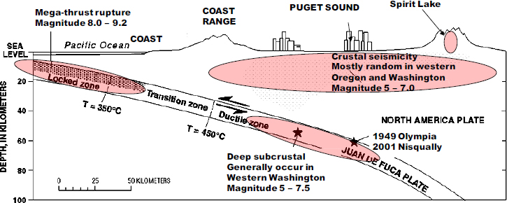
Deep and shallow crustal sources of earthquakes (see Figure 4.3) produce earthquakes of magnitudes in the range of M 5.0 to 7.5 and are of shorter duration compared to those generated by Cascadia Subduction Zone earthquakes. These can be closer to Spirit Lake and will likely produce stronger and more damaging shaking than do earthquakes originating from the locked portion of that subduction zone. Earthquakes generated in the north-south trending Mount St. Helens Seismic Zone shown in Figure 2.4 have produced numerous earthquakes of smaller magnitude than have the above two sources, and they can produce shaking very near to Spirit Lake and the SRS and hence potentially be quite damaging to elements such as the diversion tunnel and the debris blockage. The shaking amplitude can be stronger than that generated by the more distant seismic sources. Mount St. Helens is located on a Holocene active seismic zone, with numerous earthquakes with a magnitude greater than 2.0 (Czajkowski and Bowman, 2014). Volcanic earthquakes, discussed in Chapter 2, are localized earthquakes associated with magma movement. They are generally not important from a seismic hazard standpoint, but they are important as indicators of volcanic activity.
Impacts of Seismic Hazards
Seismic activity produces several hazards, each with unique physical impacts on the Spirit Lake and Toutle River system, including on engineered structures in the system. The most important of these impacts are related to ground shaking, fault displacements, landslides, and soil liquefaction, described below.
- Ground shaking—Ground motions and associated accelerations can damage features such as the tunnel and tunnel portals, the debris blockage, and the SRS. This is usually expressed as a horizontal spectral acceleration associated with a given seismic scenario.
- Fault displacements—If an earthquake is generated by rupture along a fault that crosses the Spirit Lake drainage tunnel, for example, displacement of tunnel segments could compromise its performance.
- Landslides—Ground motion during a strong earthquake can destabilize hillsides, causing mass movements that could introduce new sediment into the river system. Landslides can also block tunnel portals thus compromising its performance.
- Liquefaction—Saturated (wet), unconsolidated sediments are susceptible to a process wherein shear seismic waves cause a buildup in the pressure of pore fluids that reduces the strength of soil deposits, causing them to behave in a manner similar to a liquid. Sediment stored upstream of the SRS, for example, could liquefy during an earthquake, which could increase the horizontal load on the SRS or could lead to greater mobility of the sediments and overflow.
These impacts potentially affect all the management alternatives for drainage of Spirit Lake, including the surface channel, buried conduit, other tunnels, and the like (discussed in Chapter 5).
As with volcanic hazards, annual exceedance probabilities of anticipated ground shaking and related hazards can be developed. Analyses to date (Grant et al., 2016a) identify potential seismic hazards from the
Cascadia Subduction Zone, the Mount St. Helens Seismic Zone, and earthquakes (see Chapter 2). These analyses use U.S. Geological Survey (USGS) seismic hazards maps (Petersen et al., 2008) to obtain estimates of ground shaking based on regional geologic mapping.
Adequacy of Existing Information
Detailed probabilistic seismic hazard analysis (PSHA) and engineering analyses of fragility would be required to evaluate seismic hazards and the impacts of these hazards for the region. The level of detail in such studies should be tailored to the decisions being made and to the decision framework adopted (see Table 4.5). USGS hazard maps (Petersen et al., 2008) are useful as an initial screen tool to provide a first order estimate of the anticipated levels of shaking across the region. These maps, however, do not provide the level of resolution required for evaluating seismic hazard for critical infrastructure. Site-specific seismic hazard analysis would be required to provide estimates of anticipated levels of ground shaking at sites with features of interest and of potential fault rupture where fault zones exist.
PSHA studies are a standard part of the seismic evaluation of structures such as the Spirit Lake tunnel, the debris blockage, or the SRS. Many qualified organizations or consultants can conduct PSHAs These studies can then be used to address the behavior of a number of critical elements of the system, for example:
TABLE 4.5 Existing Seismic Hazards Information and Its Strengths and Weaknesses
| Existing information | Regional information on contributing seismic sources and estimates of ground shaking. |
| Strengths | Identifies some of the seismic hazards and their consequences. |
| Weaknesses | Uncertainties about site-specific ground motions estimates and their probabilities and related hazard, including shaking, ground displacement, and liquefaction. Some analyses based only on qualitative assessments. |
- It is not known if the Spirit Lake tunnel is traversed by a fault that might displace during a seismic event. Even without a fault, ground deformations associated with a Mount St. Helens event might cause enough shaking to collapse the tunnel. A study designed to understand the vulnerability of the tunnel to seismic ground shaking and displacement would allow for seismic hazard to be part of the risk analysis of the tunnel drainage system. At present, tunnel failure modes considered include only qualitative probabilities in the risk analyses.
- The impact of seismic shaking on potential land sliding and related damage is not known. Slope instability can lead to a blockage of the tunnel inlet or the outlet. Additionally, slope instability of the blockage may weaken the integrity of the debris blockage.
- The impact of seismic shaking on potential settlement and movement of the debris blockage. Issues that might arise due to land sliding within the debris blockage mass or from nearby landslide debris and hillsides are also not known.
- The response of the SRS with its impounded highly liquefiable sediments under seismic events is not known (although, during the committee’s open session meetings, liquefaction was said to have been observed as a result of the M 6.8 Nisqually Earthquake in February 20012). Analyses conducted thus far are based on outdated information and methodologies. Analyses are needed to evaluate the potential lateral spreading of the liquefied sediments, their impacts on the SRS, and their potential flow over the SRS.
It should be noted that much of the characterization of the region and the design and construction of infrastructure to manage the Spirit Lake and Toutle River region (e.g., the Spirit Lake tunnel and the SRS) was conducted prior to any knowledge of a potential M 9.0 Cascadia Seismic Zone event.
___________________
2 See https://earthquake.usgs.gov/earthquakes/eventpage/uw10530748#executive.
CATASTROPHIC FLOODING AND THE SPIRIT LAKE DEBRIS BLOCKAGE
The Spirit Lake debris blockage, which can be thought of as a natural dam, is a unique feature representing an unusual management challenge. The debris blockage, being a natural element of the environment, illustrates that a natural hazard is affected by the meteorological, volcanic, and seismic events already described. The integrity of the debris blockage is vulnerable to rise in lake level, volcanic eruption, and seismic shaking. If the debris blockage were breached as a result of failure of the engineered lake-level control system; piping due to a critical hydraulic head gradient in the groundwater; or erosion working headward up the debris barrier from the remnant drainage channel system of the North Fork Toutle River valley north of the volcano, it would represent a primary source of potential catastrophic flooding downstream.
Potential Failure Modes
Shortly after the 1980 eruption, rising Spirit Lake levels impounded by the unconsolidated debris blockages there and at tributary junctions downstream at Coldwater and Castle Lakes led to concerns that overtopping or the partial settling or collapse of the blockage might lead to rapid erosion and widening of a breach. Such a sequence of potentially hazardous events would allow the lake to drain within hours and create damaging floods. Youd et al. (1981) performed an initial geotechnical stability analysis of the blockage. This study assumed that hydraulic overtopping was the principal mode of failure of the blockage. Based on the original study, pyroclastic deposits were concluded to be considerably more erodible than thought earlier. As a result, the bottom elevation of the pyroclastic materials was taken to be the critical lake elevation for breaching (see Chapter 5). The USGS and the USACE conducted drilling in the blockage to identify the elevation of the contact between the avalanche deposit and the pyroclastic materials.
Calculations of likely filling times and discharges of either mudflows or muddy floods at various locations along the Toutle River (Dunne and
Leopold, 1981; Swift and Kresch, 1983; Dunne and Fairchild, 1984; Kresch, 1992) were used to estimate the probability of some form of catastrophic failure and flooding in the cases of the rising lake levels in Coldwater Creek and later at Spirit Lake unless the lakes were stabilized. Reinforced outlet channels were constructed for the impoundments at Coldwater Creek and Castle Creek in the early 1980s.
Some detailed studies have since been made of mechanisms for the breaching of the Spirit Lake debris blockage (Swift and Kresch, 1983; Sager and Chambers, 1986) and stability analysis at Castle Lake (Roeloffs, 1994). The post-1980 water level was 3,406 feet (1,038 m), and geometric interpretations of ground conditions suggested that water levels higher than 3,475 feet (1,059 m) could result in erosion and potential breaching of the blockage. The techniques applied were simple. The development of piping in the debris blockage was the only failure mechanism considered. Blockage-scale analyses for seepage force and effective stress failures were not conducted. These would have required more detailed data on geologic, hydrologic, and morphologic conditions than were available at the time or are available now.
Studies on the stability of the Castle Lake blockage (Roeloffs, 1994) indicate that if the groundwater level were to increase by approximately 50 feet (15 m), that blockage would become saturated. In that case, an earthquake of M 6.0 would likely cause failure of the blockage. The updated numerical simulation Roeloffs employed was a steady-state two-dimensional saturated groundwater flow model to assess the stability or factor of safety of the debris dam. No stress field computation was made. The factor of safety was defined by the upward critical gradient to the computed gradient. In such analysis, the actual shear strength of the debris materials was not considered. Measured water table fluctuations for the years 1991 and 1992 were used to constrain the model. Upward seepage caused a low factor of safety for the debris blockage. Geologic, geotechnical, and geophysical surveying of the blockage may be needed to determine the potential piping development over the past 36 years as well as the stress field-based factor of safety analysis.
A potential failure modes analysis (PFMA) was conducted in 2016
principally by a team from the USACE but also comprising personnel from the U.S. Bureau of Reclamation, the U.S. Forest Service (USFS), and the USGS. The present study committee did not have direct access to the results of the PFMA; it relied on a summary of those results by Grant et al. (2016a). Eleven potential failure modes were reported to have been identified by which drainage of Spirit Lake could be interrupted, with the consequence of a rising lake level eventually reaching a critical elevation against the blockage. More information about the PFMA is provided in Chapter 5.
Catastrophic Flood Magnitudes
The hydraulic analysis of a plausible Spirit Lake catastrophic breakout by Swift and Kresch (1983) indicated peak mudflow discharges of approximately 2.65 million cubic feet per second (cfs) (7.5×10⁴ m3/sec) 18 miles (29 km) downstream from the lake near the terminus of the debris avalanche deposit, decreasing to approximately 1.14 million cfs (32,000 m3/sec) at the Cowlitz River confluence and 1 million cfs (283,000 m3/sec) at the confluence with the Columbia River. The calculations also predicted depths of inundation of 60 feet (18 m) in Castle Rock and Lexington, and 30-40 feet (9-12 m) in Toutle, Kelso, and Longview. Swift and Kresch (1983) calculated that warning times for the first arrival of the lake-breakout flood were about 4 hours at Toutle village, 10 hours at Castle Rock, and 16 hours at Kelso-Longview.
The calculated boundaries of the mudflow throughout the Toutle River and Cowlitz River valleys as far as Castle Rock are consistent with those mapped by Scott and Janda (1982), although the peak discharge of the calculated flood in the middle Toutle River valley (2.55 million cfs) was significantly below the 7-10 million cfs (200,000 to 285,000 m3/s) of the lake breakout that occurred 2,500-3,200 years ago as estimated by Scott (1988a,b). Consequently, the flow magnitudes, inundation depths, and geographical extent of the estimated lake-breakout flood suggested the need for stabilizing the level of Spirit Lake considerably below an elevation that might trigger a breach of the impoundment.
Groundwater Regime of the Debris Blockage
Chapter 2 summarizes the groundwater regime within the debris blockage. The stability of debris blockage was not considered in the original Spirit Lake drainage options of buried conduit, tunnel, open channel, and permanent pumping in the comprehensive plan to manage sediment (USACE, 1983), thus leading to the decision to use the tunnel for routing the water from Spirit Lake. The comprehensive plan did not extensively consider geologic and hydrologic information, including the impact of lake level on groundwater and stability and lake sediment thicknesses. The existing groundwater regime in the blockage and in the North Fork Toutle River valley was characterized by a series of borings in the aftermath of the eruption and, more recently, by geophysical studies taken from the surface. There have been few, if any, downhole data collected since the 1980s. The result is that changes in the groundwater regime since the 1980s are poorly characterized, as is the current state of the groundwater. The recent geophysical surveys suggest that the changes since the 1980s may be modest, but the groundwater regime is of such importance to the geotechnical performance of the blockage that it would be prudent to have more up-to-date information. Such up-to-date information might shed light on whether internal erosion was taking place within the blockage and whether groundwater seepage continues to move toward Spirit Lake rather than draining away from it. There seems no reason for immediate concern other than that few recent groundwater data have been collected.
Understanding the North Fork Toutle River valley groundwater flow regime since the eruption would provide the needed scientific basis for assessing potential failure mechanisms for debris dam, surficial erosion processes, and water balance in Spirit Lake. It would also provide hydro-geologic information necessary to consider alternatives, for example, related to the control of Spirit Lake water levels.
Catastrophic Floods and the SRS
Denlinger (2011) evaluated the impact on the SRS of catastrophic floods and debris flows originating from Castle Lake and from the crater of Mount St. Helens. In each case, numerical modeling suggests that a structurally sound spillway at the SRS is capable of passing large floods without the risk of overtopping the dam itself. Large debris flows originating from these two sources never reached the SRS, instead filling graded channels upstream. While an important finding, catastrophic floods from these two sources would be small (but not negligible) in comparison to that originating from a catastrophic breakout of Spirit Lake itself. The study concludes that the valley leading to the SRS is large enough to absorb a transient peak discharge of 40,000 cubic meters per second without overtopping the SRS—about half the discharge predicted for a breakout of Spirit Lake.
Grant et al. (2016a) note that the principal current basis for predicting catastrophic flood discharges and inundation areas is the modeling work done shortly after the eruption and as compared with Holocene lahars:
But some things have changed since the 1980s which justify another look at the downstream effects of a breakout flood. The topography of the North Fork Toutle River valley has evolved considerably since the eruption and subsequent downstream delivery of sediment. Construction of the Sediment Retention Structure and its operation and filling over the past few decades has potentially changed the way lahars might behave. (Grant et al., 2016a: 110-111)
Further downstream, flood levees have been built and later raised, which may affect the extent and level of inundation. Three decades have passed and there are now better flood routing models and better understanding of floods and sediment. As Grant and others (2016a: 111) concluded, “a more informed reanalysis seems warranted.”
The early model-based estimates of potential peak flows were not based on detailed characterizations of valley topography, and though their magnitude was roughly confirmed with field evidence, there is room for
refinement of the estimates if such refinement ever becomes necessary for public policy decision making. Topographic changes that have occurred in the North Fork Toutle valley since 1980, however, are unlikely to have diminished the estimation of a debris flow, with the peak flow rate and especially of the volume and duration of a flow likely to result from drainage of Spirit Lake. The geologic evidence of prehistoric lahars in the vicinity of the SRS is that debris flows that required the release of volumes of water commensurate with a lake breakout recurred several times in multiple eruptive periods of the volcano and left evidence of reaching catastrophically high levels where the SRS stands. The peak rate, density, viscosity, and abrasive potential of these flows are many times higher than for which the SRS and its spillway were designed.
Adequacy of Existing Information
Existing information on catastrophic flooding is summarized in Table 4.6. The potential for such flooding and its corresponding consequences are reasonably well known. Geologic evidence from the early lahars off Mount St. Helens supports the modern analyses. The weaknesses in current information have to do with the fragility of the debris blockage and its corresponding vulnerability to seismic hazards, the current state of groundwater conditions, and details of current geotechnical conditions.
ONGOING MONITORING
Since the 1980 eruption much has been learned about the character of the natural hazards existing in the Spirit Lake and Toutle River system. Some informational needs remain, particularly about the engineering performance and fragility of the system when exposed to hazard events. Immediately following the eruption, there was a great expenditure of effort and resources in the 1980s to better understand the physical features of the system, but monitoring has been far less intense in recent years even given the complex and dynamic nature of the system, scientific insights, the changing priorities of interested and affected parties in the region, and
TABLE 4.6 Existing Catastrophic Flooding Information and Its Strengths and Weaknesses
| Existing information |
Potential failure modes analysis of failures of the lake drainage system Extensive 1980s data on geology of debris blockage Extensive hydrological data and analysis of runoff into Spirit Lake |
| Strengths |
Extensive analysis of what can go wrong with drainage schemes Relative certainty about the critical level of Spirit Lake |
| Weaknesses |
Seismic loading on the blockage during a Cascadian earthquake No recent geotechnical studies or analyses of blockage stability No recent geotechnical studies or analyses of possible piping No regular monitoring of present conditions and changes in ground water within the blockage Design quality understanding of the geotechnical properties Understanding the effect of a breakout flood from Spirit Lake on the SRS and the possible mobilization of sediments in the sediment plain behind the SRS |
changes in engineering practice that have taken place. The adequacy of information available to quantitatively inform any decision making is questionable. Monitoring capabilities and data collection programs need to be reexamined and updated and analytic capabilities need to be reevaluated in light of the information needs of all interested and affected parties. Those key physical variables that impact decision making need to be identified through a process in which those with management authority engage each other and other interested and affected parties in the region (as will be discussed in greater detail in Chapters 6-8). New scientific insights—for
example, that related to the probability of a Cascadia Seismic Zone event affecting the region—warrant greater examination on how such an event might affect the region and therefore management decisions for the region.
Recommendation: Agencies engaged in risk management in the Spirit Lake and Toutle River region should develop a coordinated and targeted monitoring system to track changes in factors that affect risk. Data and analyses should be shared and made available to all.
Because the Spirit Lake and Toutle River system is continually changing in response both to the forces of nature and to human intervention, information about the system needs to be regularly updated. Current characterization of the Spirit Lake debris blockage; the behavior and location of groundwater in the blockage; current and future meteorological trends; a quantified characterization of the types of risks posed by volcanic activities on Spirit Lake levels and elsewhere in the region; and the seismic response to local and regional seismic activity of the debris blockage and other parts of the system are all examples of factors that may affect the understanding of risk associated with management alternatives that might be considered. For the purposes of planning and decision making, the large body of knowledge on natural hazards needs to be integrated in a consistent way. Given modern trends in policy analysis and hazard management, that integration needs to occur through a process of systematic risk analysis.


