
3
Advances and Challenges in Addressing the Risk of Induced Seismicity
The induced seismicity panel included five presentations that addressed regional considerations, conditions, and understanding (Kansas, Oklahoma,1 British Columbia), operational factors to mitigate induced seismicity from hydraulic fracturing, and national perspectives. These presentations were followed by a panel discussion moderated by Peter Hennings (Bureau of Economic Geology, University of Texas).
PANEL PRESENTATIONS
Causality Assessment Approach: Integrating Geomechanics and Reservoir Analysis to Understand Induced Seismicity in Kansas
Tandis Bidgoli, Kansas Geological Survey
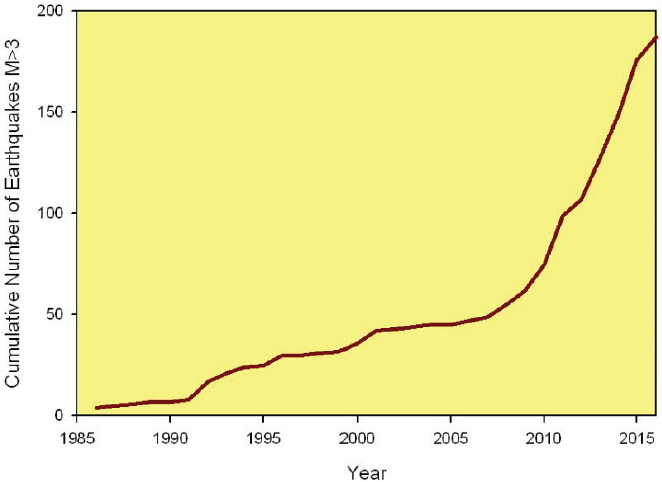
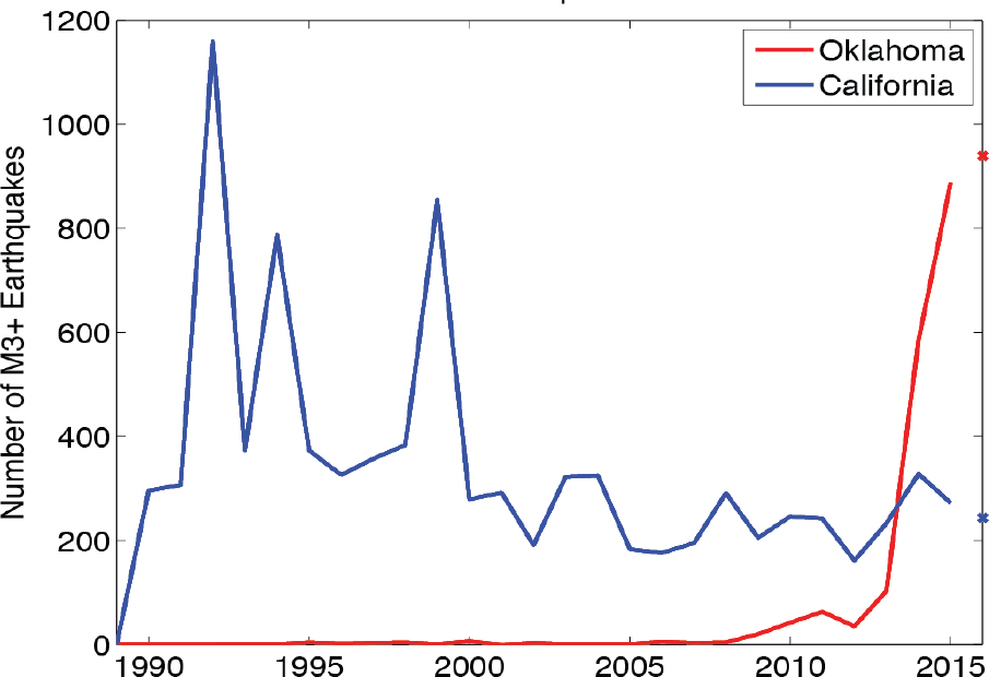
Kansas has seen a marked increase in seismicity in the state since about 2013, Bidgoli began. In a two-county area encompassing Harper and Sumner counties, more than 2500 earthquakes have been measured with more than 100 of those earthquakes having M>3. In the preceding 35 years, only 200 earthquakes had been measured in Kansas, of which just 15 had M≥3 (Figure 3.1). The two counties where a lot of the earthquakes have been concentrated also correspond to an area representing about a 25% increase in oil production in the state between 2013 and 2014. This oil production was accompanied by approximately 16 equivalent barrels of produced water for every barrel of oil being produced. As was noted in the keynote presentation, operators in Kansas typically dispose of that fluid in deep-injection wells. Bidgoli then continued to describe work at the Kansas Geological Survey (KGS) to attempt to understand the cause of the seismicity and what means might be used to anticipate or avoid generating induced events that could be felt at the surface.
___________________
1 Note that the speaker who presented on Oklahoma did not give permission to provide a summary of the presentation.
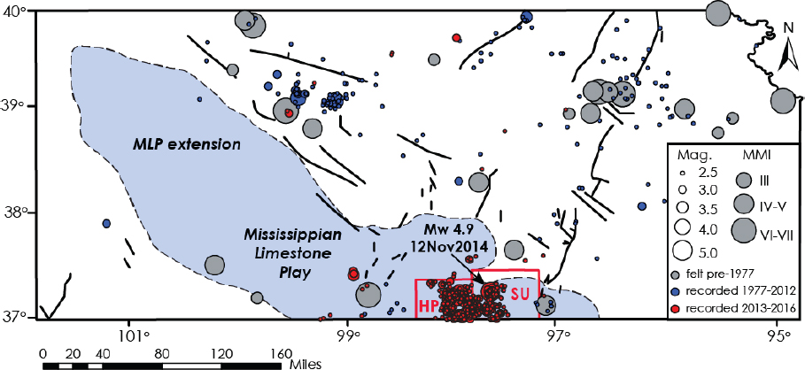
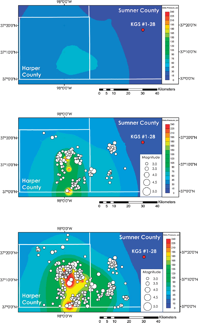
An initial examination of the operational approaches used with the wastewater disposal wells showed the results of a statewide survey plotting the volumes of saltwater disposed in the subsurface against the number of saltwater disposal wells (Figure 3.2). Bidgoli described the data from two counties, Ellis and Harper, in which substantial disposal takes place but which have very different levels of seismic activity. The data showed that while the two counties dispose of similar volumes of saltwater by injection, Ellis County has no associated seismic activity while Harper County does. Bidgoli suggested this response is due to the fact that Ellis County disposes of the water in nearly three times the number of wells as those in Harper. In Ellis County, she reasoned, the fluid pressure in the subsurface is thus distributed across a much larger area than in Harper County with the same volume of water injected in fewer disposal wells.
Bidgoli then discussed several assessment approaches the state of Kansas employs to better understand the location of faults in the subsurface and the nature of the stresses in the crust. These approaches include collection and examination of different data sets (e.g., well log, core, three-dimensional seismic, water volumes, injection and reservoir pressures), fault/lineament mapping, stress field analysis, assessment of reservoir properties, and modeling. The data sets are used, for example, to better understand the nature and characteristics of the Arbuckle disposal interval and the volume and pressure of the fluid being injected. Fault and lineament mapping takes place at regional and field scales and has been used to understand where the faults are located. Surface elevation data can be used to identify lineaments at the surface, and gravity and magnetic data may be applied to identify corresponding features in the subsurface. In addition to understanding the orientation and locations of faults, the KGS research also includes understanding the stress field around the faults. Fracture and
breakout analysis, focal mechanism inversion,2 and information from well logs that indicate the orientation and magnitude of stresses are also important tools used to understand fault properties. The characteristics of the Arbuckle unit are also important for predicting the permeability of the rocks into which water is being injected and to establish relationships between the vertical and horizontal permeability. The work she and her colleagues have done has demonstrated the existence of faults within the Arbuckle formation that truncate the basement, thus giving conductive features that allow fluid pressure to be transmitted into basement faults with the potential to generate induced seismic events.
This combination of information and data is used, she said, to try to identify which faults are likely to reactivate, through slip-dilation tendency analysis3 and oil or gas reservoir simulations (Figure 3.2). The slip-dilation analysis allows prediction about which faults are likely to reactivate, which can then be used to model what pore fluid pressure increase might be required to reactivate those structures. The simulations allow researchers to understand what the subsurface pressures are and how they behave and evolve.
Bidgoli concluded by emphasizing the importance of combining established techniques with robust geologic and geophysical data sets for making predictions about which faults may reactivate. Collaboration on the part of industry and the regulatory community is necessary to provide access to some of these data sets, which can then be employed to inform better decisions.
Operational Factors to Mitigate Hydraulic Fracture Induced Seismicity
Shawn Maxwell, IMaGE
In 2012, only two cases of hydraulic fracture induced seismicity had been documented in the United Kingdom and in Oklahoma, Maxwell said. A few additional cases have been identified since then in Ohio and in three locations in Canada. However, these kinds of induced earthquakes remain very rare and with no reported surface damage. He cited about 70 felt events that were attributable to hydraulic fracturing worldwide out of approximately 3 million hydraulic fracturing jobs that have been conducted.
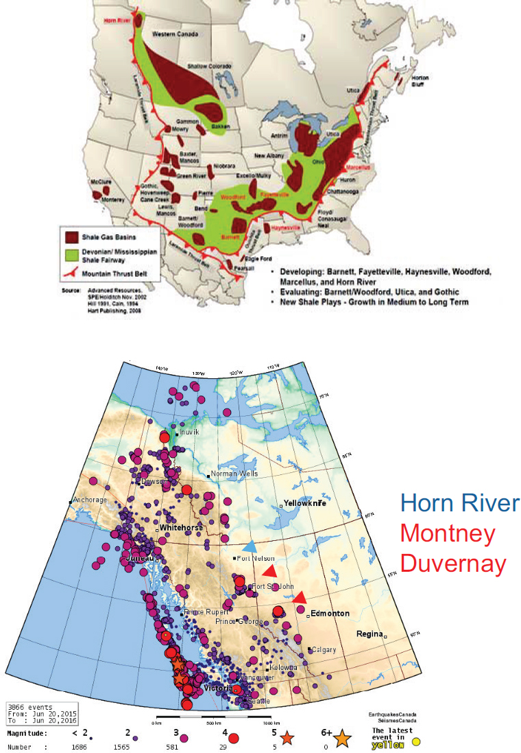
Maxwell focused on western Canada which shows an increase in the number of earthquakes through time since about 2009 (Figure 3.3). The increase in the number of earthquakes appears related to isolated events in three active hydrocarbon reservoirs, the Horn River, the Montney, and the Duvernay. One of the main geological controls (both for the hydrocarbon reservoirs and the earthquakes) in this area is the regional fault oriented NW-SE that runs along the Rocky Mountains and into the Yukon Territory and Alaska (Figure 3.4). Oil and gas reservoirs lie against this fault and in some of these reservoirs hydraulic fracturing has caused some induced earthquake activity. Maxwell referred to these three reservoirs as having seismic activity, and focused his remarks on work he and colleagues have conducted on the Duvernay. Hydraulic fracturing operation in the Horn River has ceased and so has the corresponding seismic activity. The next panelist, Stuart Venables, addresses the activity associated with the Montney.
___________________
2 The focal mechanism of an earthquake describes the deformation in the source area that generates the seismic energy; the focal mechanism includes the orientation of the fault plane and the direction of slip on that fault plane. Inversion refers to a mathematical approach to managing a large number of data to find a fit to a given solution (in this case, a fault plane).
3 Slip-dilation tendency refers to the tendency of a fault to slip or to dilate under a given stress field; analysis of these tendencies can be used to assess which faults may be critically stressed and provide an indication of their reactivation potential.
Hydraulic fracturing in the Duvernay began several years prior to the increase in seismic activity in the area in 2014. Maxwell suggested that hydraulic fracturing in a specific zone of the reservoir activated a series of earthquake events ranging from M1.6 to 4.5. In 2015, government authorities responded to this increased activity by implementing a ‘stoplight’ protocol for operators to assess and take action to mitigate the occurrence of large, felt seismic events during their injection operations for hydraulic fracturing. When seismic monitoring indicates earthquake activity passing a specified threshold, operators are to evaluate and make changes to their operating procedures to mitigate the hazard. Maxwell outlined a range of potential actions an operator can take and emphasized that each situation has to be evaluated individually and a set of actions taken that are relevant to the geological and operational conditions at that site. Potential actions include slowing the injection rate or volume, pausing or ceasing the injection activity for a given time period, skipping particular stages of the hydraulic fracturing activity, and/or changing the type of fluid being used for the hydraulic fracture well completion. Maxwell then elaborated on a few of these approaches and described how the use of microseismic monitoring data is integral to understanding the reservoir that is being hydraulically fractured and to informing what types of actions can be taken to mitigate the hazard of induced seismicity.
Using an example showing microseismic data collected by monitoring a hydraulic fracture project, he showed how the microseismic activity (typically on the order of M-2.5; negative magnitudes are too small to be felt at the surface) can allow monitoring of the growth of the new fracture network in the subsurface and help define the way that the reservoir will produce oil or gas (Figure 3.5). The microseismic activity also allows identification of pre-existing faults that may or may not already be known and into which hydraulic fracturing might otherwise
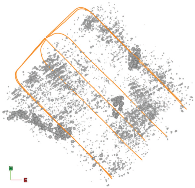
progress, potentially inducing activity on that fault that could be of greater magnitude. Monitoring the hydraulic fracturing project with microseismic arrays can thus help identify faults and fractures that can then be avoided. If a fault is unintentionally activated during the project, analysis of the locations of the faults and adjacent wells can allow operators to take action to avoid those faults or to skip a particular hydraulic fracture stage that crosses such a fault.4
Maxwell also described the use of coupled hydro-mechanical models to produce synthetic seismicity which can then be used to help quantify the seismic response on a fault that is repeatedly contacted by successive stages of hydraulic fracturing (e.g., Grob et al., 2016). These types of models can be used as a tool to examine the relative effects of what takes place along a fault when the input parameters are changed (e.g., fault orientation, changes in the stress field along the fault, changes in the position of the hydraulic fracture relative to the fault, skipping a hydraulic fracture stage when seismic activity is detected).
___________________
4 Hydraulic fracturing is conducted in a series of multiple pumping stages, starting at the far end of the horizontal well and progressing toward the well head (NRC, 2013). “Skipping” a stage that might intersect a fault would involve not hydraulically fracturing the well at that particular stage along the well and moving instead to the next stage in the series.
The modeling suggests a relationship between the amount of slip on a fault and the sequence of the hydraulic fracture stages as they are moved up the well bore. Changes in the stress field along the fault can thus be used to anticipate response of the fault system to various operational parameters, allowing more informed approaches to mitigating the potential risk of a larger seismic event.
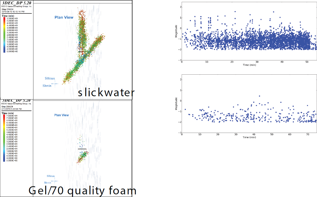
A final approach Maxwell discussed that has potential to manage the risk of inducing felt seismic events with hydraulic fracturing involves changing the viscosity of the fluids used in the hydraulic fracture project. Two examples showed the microseismic events and corresponding magnitudes of those events when slickwater was used as the hydraulic fracturing fluid and when a gel was used as the fluid (Figure 3.6). Viscosity changes are known to change the fracture network that is created which may result in a change in penetration of the fractures into an existing fault system, potentially leading to a change (reduction) in the number of felt seismic events. Although not all reservoir conditions are suited for changing the type of fluid that is used for a hydraulic fracture project, Maxwell underscored that a number of different ways exist for operators of a hydraulic fracture project to use subsurface
data, including microseismic data, and modeling to change the operational conditions in order to minimize the risk of producing seismic events that can be felt at the surface.
Understanding Induced Seismicity in Canada: Observations, Research, and Management in British Columbia
Stuart Venables, British Columbia Oil and Gas Commission
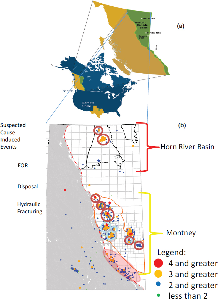
Venables structured his remarks around the history of induced seismic activity in British Columbia and the ways in which data and observations may be used to try to quantify the risk and to work with operators and others on effective mitigation strategies. Eighty-five percent of the natural gas and oil production in northeastern British Columbia derives from unconventional hydrocarbon reservoirs where hydraulic fracturing has been used; this high proportion of production from unconventional reservoirs has developed over the past decade, he said. From about 1985, when the Canadian National Seismographic Network became more robust across Canada, to 2016, British Columbia has recorded 108 events of M>3. Of those, just two were natural (due to tectonics) and the remaining 106 were due to fluid injection either from enhanced oil recovery (EOR; 31 events), wastewater disposal from oil and gas production activities (21 events), hydraulic fracturing (40 events), or some combination of hydraulic fracturing and disposal (Figure 3.7).
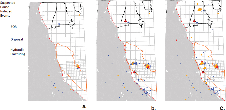
Between 1985 and 1998, the area had some induced seismic events near Fort St. John related to EOR (Figure 3.8a), he said. From 1999 to 2008, a greater number of events was recorded and interpreted to be related in some cases to wastewater disposal and in others to hydraulic fracturing (Figure 3.8b). He noted the addition of two seismometers in the area by Natural Resources Canada between 1998 and 1999 which allowed a more complete data set to be collected and analyzed. During the interval between 2009 and 2012, induced seismic events were interpreted primarily to be related to wastewater disposal although events possibly related to hydraulic fracturing also began to occur in both the Horn River Basin and Montney area (Figure 3.8c). With this increased seismic activity, the British Columbia Oil and Gas Commission (BCOGC) began working together with industry to investigate the events and assess their causes. These investigations led the Commission to develop permit conditions in the Horn River Basin to specify levels of seismic activity under which industry would be required either to shut down operations or to contact the Commission to discuss other mitigation measures. Venables suggested that permit conditions can be used as a tool to assist regulators in implementing changes in operating approaches at well sites without having to change a regulation. Changes in permit conditions also allow regulators to test particular approaches that might help inform regulatory changes in the future.
Beginning in 2013, natural gas production activity in the Horn River Basin decreased significantly, as did the seismic activity, due to declining natural gas prices; in the same period, production of oil from the Montney began to increase. In 2014, more seismic events in the Montney appeared to be related to hydraulic fracturing with some events still related to wastewater disposal and the BCOGC began to develop a more comprehensive regulatory review process that could address issues related to induced seismicity throughout the province. The formal regulations, implemented in 2015, indicated that well operators had to shut down (‘shut in’) their wells if they encountered an earthquake of M4 or greater. Although oriented toward events potentially related to hydraulic fracturing, the Commission also reviewed wastewater disposal and all of the disposal permits issued by the province. Each existing permit was reissued with stricter limits as to the magnitude of any nearby seismic activity or reservoir pressure thresholds that would require a disposal well to be shut
in or to be monitored continuously. As of the date of his presentation, Venables indicated that 10 wells had been shut in due to induced seismic activity or reservoir pressures above specified levels; two wells were allowed to continue but with a continuous seismic monitoring program.
The expansion of the seismic data set in British Columbia has allowed additional research into the similarities and differences between events, and between areas that are more seismically active or appear to be aseismic despite being in regions where hydraulic fracturing takes place. The ground motion associated with earthquakes of similar magnitude may also differ from area to area. Analysis of the data from several hydraulically fractured wells suggested that different parts of the Montney formation responded in different ways to the fluid pressure differences associated with fluid injection during fracturing. The upper part of the Montney formation is thicker than the lower Montney and seems to have few to no seismic events associated with hydraulic fracture activity into that part of the formation, he said. The lower Montney appears to respond differently when hydraulically fractured and may produce earthquakes at or above M3. Porosity differences in the formation may be contributing factors to this difference in seismic response.
Venables closed by indicating that future discussions would benefit if the focus is shifted away from earthquake magnitude to that of earthquake intensity related to ground shaking. He suggested that the intensity of ground shaking is a better representation of the risk in-
volved in any seismic event.5 He also emphasized the importance of having seismic and other associated data available in the public domain for purposes of transparency and furthering research to mitigate the risk from these events.
National Perspectives: Monitoring, Observations, and Research
William Leith, U.S. Geological Survey
Over the past six to seven years, seismologists in the United States have shifted some of their research focus from tectonically-driven seismic activity on the West Coast to induced seismicity taking place in the central and eastern United States, Leith began (Figure 3.9). This shift in attention has been accompanied by substantial progress in monitoring and understanding induced seismicity, as well as quantifying the factors that affect the risk of induced seismicity, and regulating the activities that may cause these events.
The perspectives and approaches of the regulatory community and industry have also changed over the same period of time, Leith said. When induced seismic activity first began to increase in Arkansas, Colorado, and Oklahoma, seismologists, industry, and regulators responded in different ways. As time passed, however, the research community, state and federal government agencies, and well operators began to mobilize in a more coordinated way, with additional seismometers, for example, placed in some of the more seismically active regions. These seismic data and other information have led to better understanding of the causes and consequences of the events. Today’s responses to events, such as the M5.8 Pawnee earthquake in Oklahoma in 2016 by the Oklahoma Corporation Commission (OCC), exemplify the way in which scientific understanding has formed a basis for decision making. After this earthquake, the OCC quickly established wastewater disposal restrictions in the area of the epicenter using the trend of the fault that was the locus of the earthquake to define the area for shutting in wells and implementing restrictions on injection volumes. The interpretation by the U.S. Geological Survey (USGS) that this earthquake was likely the largest earthquake ever recorded due to fluid injection was also widely accepted (McGarr et al., 2017).
Summarizing what has been learned with confidence over the past five years about induced seismicity, Leith said that most of the anomalous seismicity in the central U.S. is induced by wastewater injection unrelated to hydraulic fracturing activities. The wastewater injection in that part of the U.S. is related to other processes such as dewatering conventional hydrocarbon reservoirs. The larger induced earthquakes, often with strong ground motion, that have been observed and measured in the central U.S. occur in crystalline rocks, he continued, along faults that are well-oriented for potential failure within the stress field. The probability for strong ground motion is the basis for identifying the earthquake hazard in any given area. In the short-term, triggering these events is statistically linked to fluid injection rate with the maximum magnitudes apparently related to the total fluid volume injected. The pore pressure changes at depth in the rock formation move quickly, he said, especially in formations such as the Arbuckle which has very high permeability. When a well is shut in, the hazard of additional felt events may in some circumstances temporarily
___________________
5 Note that seismic hazard maps do report in terms of Peak Ground Acceleration (PGA), or other metrics of ground motion intensity (e.g. Figure 3.11). These estimates depend both on the size and location of earthquakes, the decay of shaking with distance (so-called Ground Motion Prediction Equations [GMPE]), and local site effects. Atkinson et al. (2015) contains additional discussion on this issue.
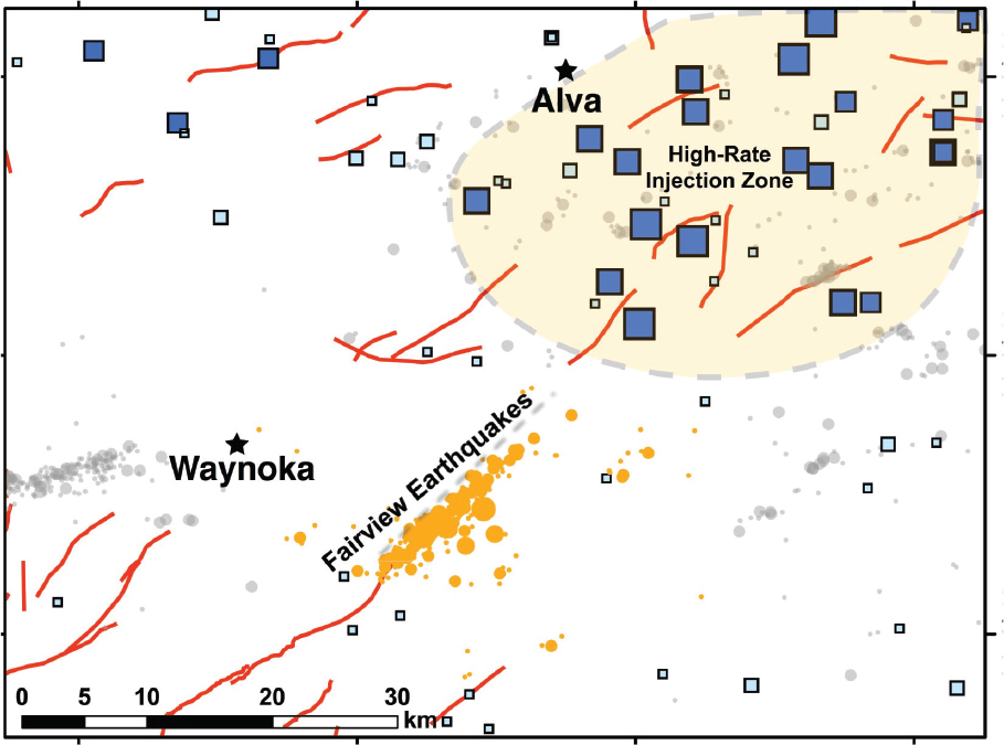
increase although the seismicity does die down over a period of time. Leith also said that evidence suggests induced earthquakes may have been undiagnosed for decades.
As researchers analyzed the movement of the fluid pressure changes at depth in rock formations, they have observed triggered earthquakes at some distance from the fluid injection site, perhaps as far as 10 to 20 kilometers away. The 2016 Fairview earthquake, as one example, was likely triggered by high-volume injection wells about eight miles away from the earthquake epicenter (Figure 3.10). Leith noted the importance of this kind of behavior as a factor for regulation, especially when multiple wells may be feeding fluid pressure pulses into a single area. Increased understanding of events such as the Fairview earthquake has also benefited from significant developments in seismic analysis techniques, which have in turn allowed unprecedented three-dimensional mapping of an earthquake sequence over time and identification of the faults in the crystalline basement that have been triggered by the injections. The earlier presentation by Zoback highlighted the application of some of these techniques.
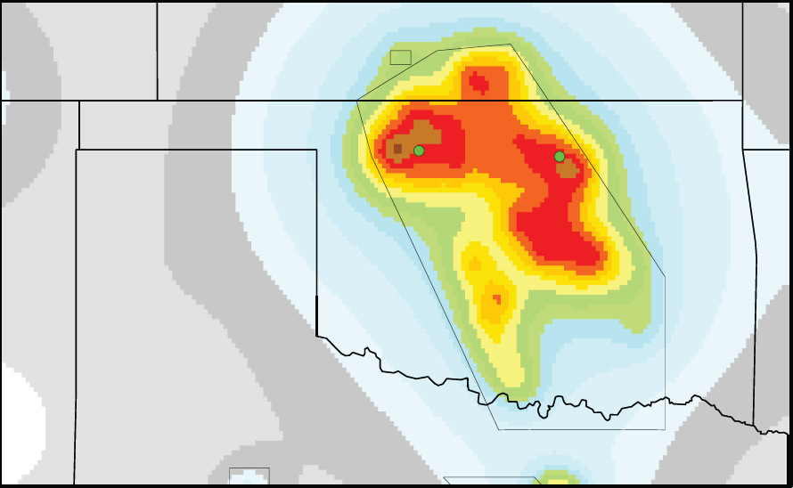
The focus in the last five years on trying to understand the hazard posed by induced earthquakes allowed the USGS to issue its first one-year hazard forecast in 2016 for 21 areas of past and ongoing induced seismicity. Using the example hazard forecast map from the Oklahoma-Kansas area (Figure 3.11), Leith said that the proportional relationship between seismic hazard and high seismicity rate suggests two conclusions when seismicity rate is also tied to fluid injection: 1) earthquakes will continue to be triggered where fluid
continues to be injected; and 2) the hazard is going to continue to be high for months or even years after injections are stopped and the pressure pulse dissipates. What Mark Zoback presented earlier in his talk, Leith said, is an excellent example of how to extend this type of forecast to be more immediately applicable on a month by month basis and to try to take into account what is known in the subsurface in terms of permeability of rock formations. He summarized the risk factors for inducing seismic events from fluid injection to include: total fluid volume being injected, rate of injection, depth of injection, bottom-hole pressure,6 proximity of injection to crystalline basement rocks, and access to faults well-oriented for failure in the ambient stress field.
Despite the substantial progress in understanding earthquakes induced by fluid injection, Leith indicated that the research still cannot easily resolve the forensic problem of which well or wells caused which earthquake. At present the data needed to address this issue—-
___________________
6 Injection pressures at the bottom of the well.
bottom hole pressures, a spatial array of deep pore-pressure monitors, stress measurements, bulk permeability measurements, and detailed subsurface geology and geophysics—are not available. Some of these data exist at sites of high interest but the data are not readily accessible. Furthermore, the community interested in these issues does not have an area to conduct controlled injections by which the effects of changing injection parameters could be directly tested. He discussed the value of having an induced seismicity test site which would allow characterization and modeling of subsurface geology, geophysics, and hydrology in four dimensions (including time). Such an experimental site, he said, could be collaborative among federal and state government, industry, and others involved in planning so that answers derived from the research could be applicable to the needs of these various stakeholders and to communities.
MODERATED DISCUSSION
One participant asked Leith if research had been conducted in areas where wastewater injection is ongoing but where seismicity does not seem to be occurring. Leith noted that the Bakken area in North Dakota is a good example of this phenomenon but that research at the USGS had not focused much to date on these types of areas. Bidgoli added that
some work has suggested that the volumes of wastewater being injected for disposal in the Bakken are smaller than those injected in Oklahoma or Kansas and that the rock formation into which the fluids are injected in the Bakken are different, as well. In North Dakota, the formation that receives the water seems to have natural seals between it and the basement rock which may prevent some fluid migration both into the crystalline basement and any basement faults. The participant followed with a question regarding the use of InSAR (interferometric synthetic aperture radar) data to determine when surface deformation begins and its areal extent associated with wastewater disposal in Kansas or Oklahoma. Bidgoli responded that some work is taking place with respect to measuring surface deformation in Kansas over the sites of wastewater disposal wells and a site where CO2 is being injected as part of an enhanced oil recovery project to see if any crustal deformation is measurable due to fluid injection at depth. InSAR data is being used as part of this work. Leith added that a recent study in eastern Texas using InSAR data did not find a signal in the area where the earthquakes occurred.
In response to a question about whether different geomechanical codes and models for examining induced seismic events had been compared or tested against one another, Maxwell indicated that they had not been, to his knowledge. He added that the use of more numerics to provide some support for interpretations of different seismic events would be a positive development. Another participant asked how routine it is to calibrate these models with respect to the observed seismic data, particularly to get a better understanding of the geomechanical properties of the rocks, including the basement. Bidgoli responded by indicating that one of the challenges with the kind of modeling she presented is the limited reservoir property information for formations such as the Arbuckle as well as factors such as basement permeability and location and conductivity of the basement faults. This area represents an opportunity for research by the geoscience community, she added. A seismology-based approach to understanding these events thus far has included identifying the locations of the earthquakes, determining which wells were in the vicinity, and examining the spatial and temporal pattern between the wastewater disposal and the earthquake. What have been more difficult to incorporate in these interpretations are the properties of the reservoirs themselves, the properties of the faults, and the properties of the basement she said. Integrating seismological information with some of the reservoir mechanical information would be a positive next step. Zoback agreed and said that the absence of some of these types of data is one of the reasons that more sophisticated models have not been used.
In response to a question about the challenges associated with identifying a specific injection well or wells that may have triggered an earthquake, Leith indicated that an experimental site, as he described in his presentation, would help to quantify how earthquakes get triggered by pore pressure changes and the pathways along which the pore pressure change is moving in the rock. The latter is a particularly significant gap in our understanding. Leith added that the permeability of the Arbuckle in Oklahoma seems to be a factor in helping to transmit pore pressure changes through the rock formation and into the basement, which also exhibits some permeability. Zoback continued by discussing the fact that while crystalline basement rocks typically have relatively low matrix permeability, the faults in the basement are preferentially permeable relative to the surrounding rock. In some cases, he said, a single earthquake is more easily correlated to a single injection site. However, in places such as Oklahoma, many wells have been injecting fluid over a long period of time and over a large area. Earthquakes are also occurring over a wide area thus, Zoback said, the interpretation of which well(s) caused the earthquake is a complicated one.
Although the risk of generating induced seismic events that can be felt at the surface from hydraulic fracturing is very small, a participant asked the panelists to comment on the
potential to reduce that risk further by bypassing some stages of a hydraulic fracturing job to avoid faults and by changing hydraulic fracturing fluids from a lower viscosity fluid (e.g., “slickwater”) to a higher viscosity gel type of fluid. Maxwell indicated that while reducing the number of stages could be positive in terms of reducing the potential to induce earthquakes, avoiding faults is equally important. Many well operators proactively avoid faults when they observe them in seismic data sets. The question of which fluids to use is a good one but difficult to test, Maxwell continued. Slickwater fractures can generate very long fracture dimensions which may have greater potential to intersect faults. Fluids with higher viscosity may help to reduce that kind of potential fault contact. At this point, definition of best practices and potential mitigation steps for reducing the risk of inducing earthquakes from hydraulic fracturing requires additional work, he said.
One participant noted that the British Columbia example demonstrates that hydraulic fracturing can trigger fault seismic events; however, these events seem to have been infrequent in U.S. hydraulic fracturing areas. In response to this question about the primary difference between the British Columbia areas that have had triggered seismic events from hydraulic fracturing and those in the U.S. that have not, Zoback suggested that the main difference is the presence of more potentially active faults in that geologic region of British Columbia. Venables continued by indicating that the management of disposal wells in British Columbia is also different in part due to the types of reservoirs into which injection is taking place in the province compared to the rock units into which wastewater disposal takes place in Oklahoma and Kansas. The units in British Columbia are bounded, finite reservoirs; those in Oklahoma and Kansas are essentially infinite reservoirs. Venables and Maxwell also noted the importance of exchanging information about and approaches to induced seismicity from different regions. The geologic context is different when comparing western Canada to Oklahoma and Kansas, or other regions, and a science-based discussion can help inform decisions and regulation. Cooperatively, industry, academia, and the regulatory bodies have attempted to learn together about induced seismicity and how to address it in western Canada, they said.
In response to a question as to whether the fault style (normal, reverse, or strike slip) would have any bearing on the threshold for triggering an induced seismic event or the magnitude of such an event, Zoback responded by indicating that no correlations between fault type and magnitude have been observed to date. No events will be observed in reverse faulting environments because horizontal drilling and multi-stage hydraulic fracturing do not work when the hydraulic fractures are horizontally oriented. Most of the faults in Oklahoma are strike slip with a few normal faults, while Kansas has significant normal faults and most of the Canadian events are a combination of strike slip and compressional, yet all of these areas have similarities in the range of magnitudes of the earthquakes. Bidgoli added that the main difference between faults may be how much pore pressure a fault can accommodate before generating a seismic event. A participant asked about the importance of various characteristics of basement faults, in addition to their orientation in the stress field, in helping to determine which faults may be of most concern. Zoback indicated that basement faults are of greater concern because those are the faults that may be large enough to cause earthquakes of sufficient magnitude to cause surface damage. The physical size of those types of faults cannot be accommodated just in the sedimentary rock section.
Intelligent strategies in terms of spatial and vertical distribution of disposal wells over time was raised by a participant as a potential means to manage the pore pressure change of the rock systems in a better way. The panelists shared examples from Kansas and Oklahoma where the state regulatory agencies who oversee well permits have indicated to well operators that wells in certain areas will have caps on the volumes of fluids that can be injected
on a daily basis. Another regulatory strategy is not to permit wells in earthquake-prone regions, indicated one of the panelists. In Oklahoma, a produced water working group has been established to help bring together different stakeholders to address and respond to changes in water disposal volumes over time. Zoback added that consideration is needed of the broader question of water supplies on a regional basis and how water disposal strategies might be combined with water treatment efforts to help alleviate issues in areas experiencing water scarcity or stress. Bidgoli continued by indicating the importance of ensuring that the regulatory agencies charged with managing these large numbers of wells have enough staff and resources to conduct their work.
Citing the information that about 10 percent of the U.S. population relies on private water wells for their water supply, a participant emphasized the need to continue monitoring the potential for hydraulic fracturing or wastewater disposal to affect the quality or quantity of these local supplies. Some Kansas counties, Bidgoli responded, have very active oil and gas development activities but are also water stressed. An active area of discussion and planning at the state level is to examine possibilities for water reuse and recycling to ensure that local water supplies are not necessarily being used or depleted from the oil and gas development activities. In this regard, she said, a great deal of work also remains to be done to understand the brines themselves and their chemistries. The chemistry of these waters is important both for potential reuse in the oil or gas production and also for other purposes. She added that there is additional cooperation among state surveys, industry, and the regulatory agencies to use data sets, but to employ them in ways that are sensitive to the competitive advantages that proprietary data sets may provide to an individual company. A panelist noted a challenge in looking holistically at the potential impacts of oil and gas activity to groundwater supplies because different regulatory bodies at the state level address different parts of the activities; the body that permits the disposal well is not necessarily the same government body that oversees the environmental quality and monitoring aspects related to water. A role may exist for professional organizations or other non-governmental groups associated with groundwater issues to help solve some of these gaps in knowledge and approaches between those who produce, regulate, and dispose of water to help protect individual domestic wells. A participant noted that industry and regulators have to balance responsible disposal of wastewater in injection wells with costs of water treatment and/or recycling.
Hennings posed a final question to the entire panel with regard to whether the future for induced seismicity is one where these events are managed and mitigated, or whether efforts are actually focused on a future state of no injection-related seismicity at all. Bidgoli suggested that the answer depends on what level of risk is determined to be acceptable by all of the stakeholders including local communities. Zoback followed by indicating that managing risk is very important but that the management tools are different. In areas such as Pennsylvania where most of the produced water is recycled and not injected into disposal wells, triggering earthquakes is minimized through water management. Elsewhere, when large volumes of salt water elsewhere are disposed through injection, our evolving understanding of induced seismicity can be continuously communicated to regulators and industry so that they can incorporate the information appropriately in their approaches to minimize the risk. The problems are real, he added, but we have made significant advances in what we know today relative to five years ago with regard to induced seismicity.


