
CHAPTER 2
Background of the Gulf Coast System
The Gulf of Mexico is a marginal sea of the Atlantic Ocean, with substantial mixing of Atlantic and Gulf waters (see Khade et al., 2017, for a recent discussion), including inflows of saltwater from the Caribbean Sea and freshwater from two-thirds of the conterminous United States and a portion of Canada. Formed 165 to 142 million years ago as seafloor spreading continued following the breakup of the supercontinent Pangea (Stern and Dickinson, 2010), the Gulf had opened to the Atlantic Ocean approximately 155 million years ago. Over millions of years, the deposition, subsidence, and chemical alteration of organic-rich sediments within the historical Gulf of Mexico basin resulted in the creation and storage of vast energy resources. Through more than a century of exploration, major hydrocarbon (oil and natural gas) quantities have been found in much of the basin’s sedimentary layers, particularly in areas now located in the northern1 and northwestern2 Gulf of Mexico (Galloway, 2008).
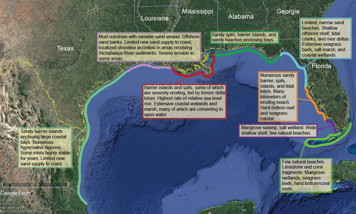
The Gulf coastline consists of a range of different types of coastal settings (see Figure 2.1), including barrier islands and peninsulas, tidal inlets and tidal deltas, rivers and river deltas, cheniers, bays, marshes, cypress swamps, and mangrove forests, all of which respond differently to changing environmental and anthropogenic stressors. About two-thirds of the northern Gulf Coast consists of barrier islands or spits (e.g., Morton et al., 2004), low-lying, sandy landforms backed by coastal bays or lagoons and separated from each other or the mainland shore by tidal inlets. Because barrier islands are primarily composed of shifting sand, the structure and composition of each island is unique (Pilkey, 2003). The remainder of the coastline consists of mainland shore without an intervening bay or lagoon, including sandy beaches and bluffs and marsh shorelines. The Gulf Coast
___________________
1 The northern U.S. Gulf of Mexico extends from Galveston Bay, Texas, to the mouth of the Suwannee River, Florida.
2 The western U.S. Gulf of Mexico is the Texas coastline, west of approximately 94° longitude. The central Gulf coast encompasses Louisiana, approximately 94° to 89° longitude. The eastern Gulf refers to Mississippi, Alabama, and Florida, approximately 89° to 83° longitude.
includes many large estuarine systems (e.g., Barataria Bay, Corpus Christi Bay, Galveston Bay, Mobile Bay, Pensacola Bay, Sabine Lake, Tampa Bay) and several hundred small estuaries (EPA, 1999). Many of the large bays (e.g., Mobile Bay, Alabama) are drowned river valleys that flooded as sea level rose following the Last Glacial Maximum or are associated with inter-distributary bays in the Mississippi River Delta.
The Gulf barrier islands, along with other coastal landforms such as most modern major river deltas, estuaries, and coastal wetlands, were formed approximately 5,000 to 6,000 years ago as sea level rise slowed during the late Holocene Epoch (Stutz and Pilkey, 2011; Anderson et al., 2014). Most evolved along non-deltaic shorelines, while a smaller number (e.g., the Chandeleur Islands, Louisiana) are younger, having formed along deltas dominated by tidal and wave energies and characterized by moderate supplies of fluvial sediments (Penland et al., 1985, 1988; Otvos and Carter, 2013). Given some debate among investigators regarding the characteristics that distinguish barrier islands from other types of coastal islands (Otvos, 2012), the Gulf of Mexico includes 116 barrier islands of both non-deltaic (coastal plain) and deltaic origins, representing approximately 5 percent of the world’s total number and a combined island length of 2,398 kilometers (Stutz and Pilkey, 2011).
People have lived along the Gulf Coast for at least 14,500 years (Halligan et al., 2016). It is not known whether human modifications to the physical landscape during the pre-colonial period altered coastal geomorphology in significant ways, but there is clear evidence that people in the colonial period altered the local geomorphology in the coastal zone. In early 18th-century New Orleans, the French built a mile-long bulwark on top of a natural levee. By 1763, 50 miles of waterfront had levees (Colten, 2005). Large reclamation projects, shoreline armoring, canal building, and port and channel dredging did not begin along the western Gulf Coast until the 19th and 20th centuries. These much more extensive changes broadly transformed the landscape and altered physical and ecological processes.
Today, the Gulf Coast states—Alabama, Florida, Louisiana, Mississippi, and Texas—are home to approximately 19 percent of the U.S. population.3 The Gulf Coast is generally less urbanized than the rest of the coastal United States, and coastal counties are less densely populated compared with the U.S. average coastal county population density (Wilson and Fischetti, 2010). However, major metropolitan regions exist near Houston and Galveston, Texas; Tampa Bay, Florida; and to a lesser extent, around New Orleans, Louisiana. Since 1960, the population in most Florida Gulf Coast counties (including the Tampa Bay area), as well as the Houston metropolitan region, has increased at a rate faster than the U.S. population (Wilson and Fischetti, 2010; NOAA, 2013; U.S. Census Bureau, 2018). With
___________________
3 Percentage calculated from 2017 population estimates available at: https://www.census.gov/data/tables/2017/demo/popest/state-total.html.
a few exceptions, the remainder of the Gulf Coast counties increased at a rate slower than the U.S. average, or even decreased in population. The demographic and socioeconomic profile of Gulf Coast residents largely mirrors the U.S. population as a whole, but with somewhat greater ethnic diversity and larger income disparities than other regions. The Gulf Coast population tends to be older, earns a lower median household income, and includes a greater share of African American residents compared with the U.S. national average (NOAA, 2011). Gulf Coast communities also show higher poverty rates than the nation as a whole (NOAA, 2011). A growing literature suggests that these characteristics are associated with greater social vulnerability to the effects of sea level rise, hurricanes, and other hazards—meaning that they are less able to prepare, respond, rebuild, or relocate before or after disasters (Cutter and Emrich, 2006; Cutter et al., 2006, 2008; Picou and Marshall, 2007).
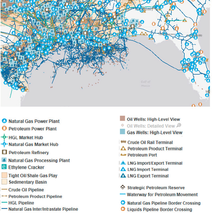
An important driver of human interaction with the environment, and a significant reason behind population growth and many of the modifications to the landscape and coastline over the past century, involved infrastructure related to the extraction of energy resources. President Truman’s declaration of federal jurisdiction over the continental shelf led to the granting of offshore oil and gas leases, beginning in 1947. In 1953, the Submerged Lands Act granted states jurisdiction from the high-tide line to 3 miles offshore. These policies led to a significant increase in the construction of oil and gas infrastructure within the coastal zone (especially along the northern and western Gulf states), including production and processing facilities, canals dredged for providing access to construction equipment, land reclamation by draining and filling of wetlands, and the development of supporting transportation infrastructure such as deep water navigation channels and ports. The latter expanded dramatically in the post–World War II period, with the biggest changes in the 1950s to late 1970s (Theriot, 2014). As a result, the Gulf Coast has historically been, and continues to be, a dominant contributor to the nation’s crude oil and natural gas production. More than 51 percent of total U.S. petroleum refining capacity, and more than 50 percent of total U.S. natural gas processing plant capacity, is located along the Gulf Coast (EIA, 2017b,c). There is a vast amount of infrastructure associated with not just production and processing facilities, but through the entire oil and gas supply chain, including storage (e.g., aboveground and underground tanks) and transportation and distribution (e.g., pipelines, ports, canals, waterways, roads, railroads) (see Figure 2.2; CCSP, 2008; Dismukes, 2011; Needham et al., 2012; Theriot, 2014). The result is an extensive and complex infrastructure that developed to meet national and global demands for the exploration, extraction, transport, and use of Gulf of Mexico energy resources.
NOTE: HGL refers to hydrocarbon gas liquids; LNG refers to liquefied natural gas.
THE COUPLED NATURAL-HUMAN SYSTEM
A common theme in the Gulf Coast’s environmental history is the importance of interactions and feedbacks between and within the natural (physical and ecological) and human systems. An interaction exists when system A affects system B or system B affects system A, while a feedback exists when system A affects system B, and system B, in turn, affects system A as a two-way interaction (see Box 2.1).
Examples of physical-ecological interactions in the coastal zone are numerous and include loss or gain of coastal habitats in response to sea level rise (e.g., Day et al., 2008; Kirwan and Megonigal, 2013), coastal storm inundation of wetlands (e,g., Howes et al., 2010; Tweel and Turner, 2012a), contribution to wetlands by sediment flow from a large
river (Paola et al., 2011; Kolker et al., 2012; Esposito et al., 2013), damping of waves by vegetation (e.g., Kobayashi et al., 1993) and corals (Lugo-Fernández et al., 1998), reduction of storm surge by vegetation (Wamsley et al., 2010), and loss of barrier island ecosystems in response to sea level rise and low shoreface sand content (e.g., Fearnley et al., 2009; Otvos and Carter, 2013; Moore et al., 2014). Irish et al. (2010) showed increased back-bay flooding during coastal storms following barrier island dune degradation. There are also various physical-ecological feedbacks. An example is the alteration of barrier island topography as sea level rise and increasingly episodic inundation lead to loss of dune habitats and lower island topography, which is then more vulnerable to inundation (i.e., a self-reinforcing feedback; e.g., Durán and Moore, 2015).
The feedbacks between the natural and human components of the coastal system are especially important for understanding future coastal evolution. As natural coastal changes occur, people respond by making modifications, which in turn alter evolution of the natural system, thereby further influencing human behavior. A classic example of such a feedback is often set in motion by coastal erosion. In response to erosion, protective infrastructure (e.g., a seawall) is installed, which reduces erosion rates, leading to more coastal development because the risk of storm damage has been reduced. The seawall could also affect sediment dynamics at neighboring communities, possibly causing more erosion and triggering further installation of infrastructure. These types of feedbacks between the human and natural systems are discussed in more detail in the last section of this chapter.
Tipping Points
An important concept used in modeling coupled systems is that of a tipping point, a critical point “at which a sudden and dramatic shift to a contrasting dynamical regime may occur” (Scheffer et al., 2009, p. 1). The long-term dynamics of the Gulf Coast raise the possibility of tipping points in the coupled ecological-physical system and provide a way to consider the coupled natural-human system. For example, continued sea level rise and changes in sediment supplies could eventually trigger a breach in a barrier island. While the initial breach area would be relatively small, given limited sediment supply and rising sea level the breach would very likely continue to widen, allowing more water in and out of the system, eventually leading to substantial land loss. In this way, a relatively small event (e.g., a breach) could lead to substantial changes in hydrodynamics that would cause a significant qualitative change in the coupled ecological-physical system because it would radically alter salinity and expose coastal marshes and other mainland habitats to waves, tides, and storm surge (Culver et al., 2007).
Large breaches or a total loss of barrier islands could also lead to tipping points in the coupled natural-human system; for example, the complete disappearance or relocation of the community occupying the island, or major shifts in flood frequency for a community
behind the barrier island. In contrast to incremental outmigration in response to sea level rise (Hauer, 2017), a tipping point in this context is a point of no return, a critical juncture after which a coastal community eventually will cease to exist in its original location.
Even without full-scale disappearance of barrier islands, physical changes in the coastal zone could lead to tipping points in the coupled natural-human system. For example, as sea level rise and wetland loss continue, many oil and gas pipelines continue to be maintained even though their vulnerability to wave action increases. However, a tipping point may be reached after which further incremental change in sea level or wetland loss leads to increased damage and associated maintenance costs, triggering abandonment of some of these assets with resulting implications for cleanup costs and the need to move or store energy resources differently. Another tipping point relevant to the energy sector is the potential for a qualitative change in the energy workforce along the Gulf Coast. As sea level rise contributes to outmigration and land loss increases areas of open water, the labor force who can commute by car to oil and gas processing and distribution facilities in the coastal zone shrinks. Eventually, the labor force may rely on ships and aircraft to reach these facilities, increasing costs for facility operators who could, depending on the price of oil, cause their abandonment.
Decision Making Under Deep Uncertainty
Making very detailed or accurate predictions about exactly how the Gulf Coast will evolve over the next 10 to 200 years is not, of course, a realistic possibility. The uncertainties (both human and natural) over that period are simply too large, and outcomes will depend in large part on policy decisions occurring at the national or the international level (e.g., carbon emissions mitigation, global economic trends). It may be difficult or even impossible to characterize these long-term uncertainties using probability distributions, or there might be substantial disagreement regarding the likelihood of different outcomes. This is sometimes referred to as deep uncertainty, and it challenges decisions made in the near term that will nevertheless shape the long-term future (Lempert et al., 2003).
Improving understanding of the Gulf Coast coupled system and its interrelationships, however, can support better near-term decision making, even when faced with deep uncertainty. Researchers and practitioners can use an “exploratory” approach when developing and applying simulation models to conduct future scenario analysis (Bankes, 1993). This approach uses quantitative models as platforms to ask “what if?” questions rather than seeking to predict the future, providing a way to plausibly link different assumptions about future uncertainties to outcomes across the Gulf Coast coupled system, as well as to consider how policy changes or new investments might perform against a wide range of future conditions.
The field of decision making under deep uncertainty (DMDU) has evolved from this basic premise. DMDU methods include systematically testing policy choices or infra-
structure plans against a wide range (i.e., thousands to millions) of plausible futures and identifying those plans that are more robust, meaning they perform well regardless of how the future plays out (Groves and Lempert, 2007; Hallegatte et al., 2012; Walker et al., 2013; Herman et al., 2015). Often, this entails creating adaptive plans that specify adjustments over time in response to new information, as well as key tipping points or conditions that could be monitored to inform these adaptive pathways (Kwadijk et al., 2010; Groves et al., 2013; Haasnoot et al., 2013). DMDU approaches, such as Robust Decision Making, also help identify “low-regret” choices that are insensitive to future uncertainty, as well as “decision-relevant” scenarios that illuminate key tradeoffs and can help to inform policy deliberations (Bryant and Lempert, 2010).
THE NATURAL SYSTEM
Physical Processes
The Gulf Coast is a complex region, governed by a combination of physical drivers originating in the ocean, in the atmosphere, and on land. The Gulf Coast itself is a microtidal environment, with astronomical tides of 1 meter or fewer in most places (NOAA, 2018). The region is dominated by broad, shallow continental shelves—except near the mouth of the Mississippi River, which discharges into deep water. Given the region’s mostly shallow bathymetry, estuaries and many nearshore coastal environments are often well mixed. However, intense stratification occurs around the Mississippi River plume, where a lens of freshwater several meters thick can develop (Walker, 1996; Kolker et al., 2014). The Loop Current, a geostrophic current that originates in the southern Gulf and can extend northward, is a dominant feature of the pelagic zone and can transport heat and moisture northward to the coast (NASEM, 2018). Climatologically, the region is dominantly subtropical to tropical, with warm temperatures that fuel atmospheric convection and intense thunderstorms (particularly in the summer) (Kumpf et al., 1999). During summer and autumn, the entire Gulf Coast is prone to experiencing tropical cyclones, which can be the most severe driver of physical processes in the region (Trenberth et al., 2007; Miner et al., 2009). The northern Gulf is also prone to cold fronts, which strike on an approximately weekly basis between October and April (Roberts et al., 1989; Allison et al., 2000). These can be important drivers of mixing, sea level change, and coastal erosion.
SEA LEVEL RISE
Low-elevation coastal zones such as the Gulf Coast face increased vulnerability, now and in the future, as a result of accelerating rates of relative sea level (RSL) rise (Nerem et al., 2018). RSL rise is determined by global sea level rise plus change in land elevation
associated with subsidence. These processes give rise to spatially and temporally variable patterns of local RSL change.
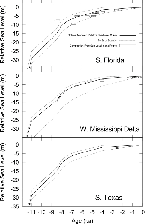
During the Last Glacial Maximum (21,000–26,000 years ago), global sea level was about 135 meters lower than the level observed today (Lambeck et al., 2014) because ocean water was locked up in continental ice sheets, mainly those that covered large parts of North America and Eurasia. The Antarctic and Greenland ice sheets, as well as mountain glaciers, were also considerably larger during the Last Glacial Maximum. The transition into the present interglacial period and associated global sea level rise occurred between 21,000 and 7,000 years ago—its end coincided with the demise of the Laurentide Ice Sheet in North America. Despite the slowdown in the rate of global sea level rise, which persisted until the early 20th century (Gehrels and Woodworth, 2013), the Gulf Coast has seen continuous RSL rise due to subsidence associated with glacial isostatic adjustment. Figure 2.3 illustrates RSL curves for selected Gulf Coast regions, obtained from geophysical modeling of glacial isostatic adjustment and validated by geological RSL data.
Modern average, long-term RSL rise rates determined from National Oceanic and Atmospheric Administration (NOAA) tide gauges along the Gulf Coast (including both changes in water level and changes in vertical land movement) range from 1.38 millimeters per year (mm/yr) at Apalachicola, Florida, to a maximum of 9.65 mm/yr at Eugene Island, Louisiana (Pendleton et al., 2010). These rates, however, may be higher or lower for periods of time, such as during times of high fluid extraction (Kolker et al., 2011; Jones et al., 2016). Satellite altimetry data from the Gulf of Mexico show a mean present-day sea level rise (i.e., rise in water level alone) rate of 2.0 ± 0.4 mm/yr (Letetrel et al., 2015), although spatial variability within this region is very high due to processes such as the migration of the Loop Current, which can be an important control on sea surface heights (Liu et al., 2016). Other studies (e.g., Rietbroek et al., 2016) have suggested that rates in the western Gulf of Mexico are higher. Since changes in RSL are affected by the rate of change in all of the processes mentioned above, each is addressed in turn in the following section.
Sea level is rarely stable because changes in ocean water mass and volume are ongoing. Changes in the cryosphere (glaciers and ice sheets) will have a profound impact on low-elevation coastal zones worldwide. Ice loss in Antarctica is of particular importance to the Gulf of Mexico, given that the largest sea level rise due to the melting of the West Antarctic Ice Sheet (the most vulnerable portion of the Antarctic Ice Sheet) is centered on the northwestern Atlantic (Mitrovica et al., 2009).
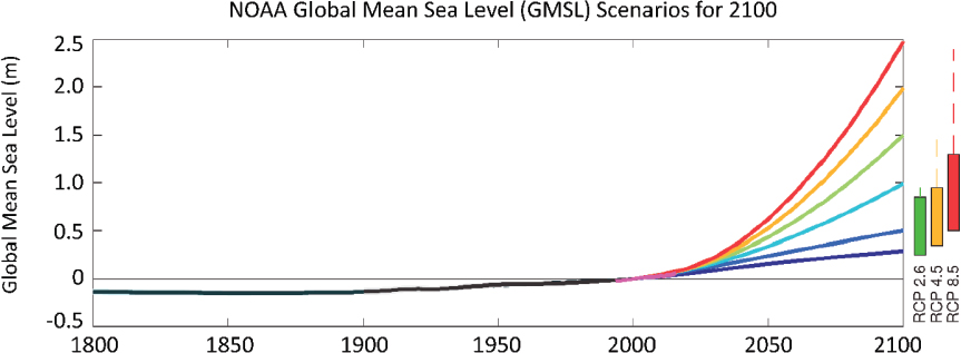
Global sea level has been rising since the mid-1800s, and significant global sea level rise has been recorded over the past 100 years (see Figure 2.4), to a notable extent due to thermal expansion and melting mountain glaciers. Global sea level projections from the most recent Intergovernmental Panel on Climate Change report (2013) are now considerably higher, to a large extent due to the recognition of ice sheet instabilities (DeConto and Pollard, 2016).
Future sea level rise predictions suggest a rise in global sea level of 0.3 to 2.5 meters by the year 2100, with an intermediate-high value of 1.5 meters (Sweet et al., 2017).
Dynamical sea level adjustments also occur. These are changes in sea level that are driven by long-term (i.e., annual to multi-decadal) changes in winds, atmospheric pressure, ocean currents, and similar phenomena that shift the distribution of water masses (Kolker and Hameed, 2007; Sturges and Douglas, 2011; Liu et al., 2016). These shifts can be driven by year-to-year fluctuations in weather, internal modes of climate variability (e.g., the El Niño Southern Oscillation, the North Atlantic Oscillation, and the Atlantic Multi-Decadal Oscillation), and long-term changes in climate. Dynamical sea level can
contribute to variability and trends on multiple timescales. On a year-to-year basis, it can result in about +/– 10 centimeters of sea level change, which can potentially obscure tide gauge records that provide insight into climatically and subsidence-driven sea level rise (Kolker et al., 2011). Dynamical sea level is likely to contribute about 5 centimeters of total sea level rise for the Gulf Coast during the remainder of this century (Hall et al., 2016, and references therein).
Dynamical processes drive sea level change on shorter timescales as well. Loop Current migration is one driver and can be addressed with data-assimilative efforts (e.g., Hoteit et al., 2013). Another particularly important process is the cold front cycle, which occurs on approximately weekly timescales from October through April and leads to local temporary sea level rise on the order of 0.25 to 1 meters and temporary sea level drop on the order of 0 to 0.5 meters (Allison et al., 2000). The asymmetry in the size of the surge versus recession is often a function of the shallow nature of the system and the duration of the pre- and post-phases of a front (Roberts et al., 1989, 2015; Draut et al., 2005). While the magnitude of frontally driven sea level change is substantially less than a storm surge (e.g., up to ~10 meters during Hurricane Katrina), the regular occurrence of these events makes
them among the most important current short-term drivers of sea level change across the northern Gulf Coast.
SUBSIDENCE
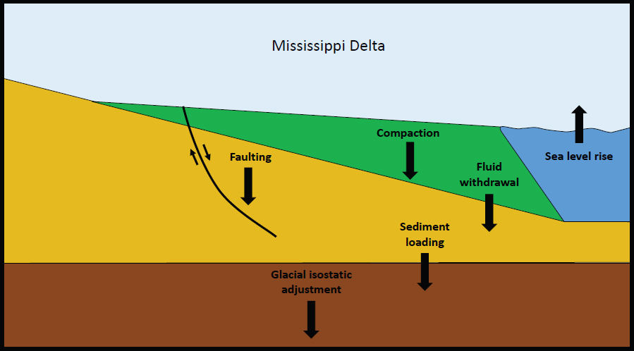
Much of the Gulf Coast is subsiding, but the driving processes and their rates vary by several orders of magnitude, depending on the geographic location. Important drivers include tectonic processes, faulting, sediment loading, glacial isostatic adjustment, compaction, and fluid withdrawal (see Figure 2.5).
The Florida peninsula is tectonically stable, as it consists predominantly of Cenozoic carbonate bedrock. By comparison, the remainder of the Gulf Coast is underlain by thick clastic layers, dominantly mud and sand, that exhibit deep-seated subsidence rates of typically less than 0.25 mm/yr (e.g., Woodbury et al., 1973; Paine, 1993). Shore-parallel growth fault systems are very common along the Gulf Coast west of Florida (Murray, 1961). Few studies, however, have quantified fault slip rates. Recent studies have focused mainly on the Baton Rouge Fault Zone in Louisiana, with reported time-averaged slip rates of 0.2 to 1.2 mm/yr over the past ~4,000 years, although rates averaged over longer timescales (~30,000 to 130,000 years ago) are an order of magnitude lower (Yeager et al., 2012; Shen et al., 2017). An example of relatively recent fault activity, with maximum throw estimated
at 75 centimeters over 40 to 50 years, was reported from a coastal wetland setting in central Texas (Feagin et al., 2013). The understanding of recent faulting in the region is an area of emerging research.
Glacial isostatic adjustment is related to the existence of the up to 4 kilometer thick Laurentide and Cordilleran ice sheets during the Last Glacial Maximum. The weight associated with these ice sheets led to a depression of the Earth’s crust at their locations and an associated uplift in a large region surrounding the ice sheets. Once the ice sheets retreated, the areas that experienced uplift, including the Gulf Coast region, began to subside. Associated subsidence due to glacial isostatic adjustment along the Gulf Coast continues today at rates between 0.3 and 1.5 mm/yr (Love et al., 2016). Widely spaced tide gauge-derived rates do not account for the full range of variability in subsidence in the region; rates of RSL rise are likely higher in places with high rates of shallow subsidence such as in coastal Louisiana (Nienhuis et al., 2017). Compaction is an important process in settings that experience rapid sedimentation. It includes primary consolidation (i.e., the rapid release of porewater from the shallowest water-lain strata during burial with younger sediments) and secondary consolidation (i.e., the realignment of sediment grains due to gradually increasing stress resulting from increasingly deep burial). Sediment compaction has long been recognized as a major driver of subsidence in coastal Louisiana (Penland and Ramsey, 1990), but separating compaction from other subsidence processes is difficult. Recent studies have documented compaction rates of 5 to 10 mm/yr within the past decade (Jankowski et al., 2017) and 1 to 5 mm/yr within the past ~1,500 years (Törnqvist et al., 2008). Because compaction is so prominent in the shallowest subsurface (i.e., depths of 5–10 meters), it exhibits high spatial variability (Jankowski et al., 2017); as a result, rates of RSL rise can vary spatially by an order of magnitude.
Another potential driver of subsidence along the Gulf Coast is sediment loading. Isostatic adjustment due to sediment loading is a smaller contributor to subsidence (i.e., less than ~0.5 mm/yr) than glacial isostatic adjustment, even in a major area of sediment deposition such as the Mississippi Delta (Wolstencroft et al., 2014), and much smaller than sediment compaction. The spatial extent of sediment loading, however, is relatively large compared with shallow subsidence processes, and its footprint may extend well beyond the actual area of sediment deposition.
Finally, the withdrawal of subsurface fluids can play an important role in Gulf Coast subsidence. Fluid withdrawal can take place at multiple depths across the sedimentary column and a variety of fluids can be withdrawn (e.g., oil, gas, water, sulfur) for energy production, industrial uses, drinking water, cooling, and management practices. In urban areas such as New Orleans and Houston, groundwater is often pumped out as part of stormwater management actions. The resulting desiccation and increased oxidation rates of buried organic matter cause further subsidence (e.g., Snowden et al., 1980; Stephens et al., 1984; DeLaune et al., 1994). A prominent example of this is metropolitan New Orleans,
where water withdrawal has caused parts of the city to subside by 3 meters or more in some places since about 1900 (Snowden et al., 1980; Dixon et al., 2006). Groundwater withdrawal has also been associated with up to 3 meters of subsidence in Galveston and Houston (Winslow and Doyel, 1954; Kasmarek, 2013). Groundwater is also removed from the subsurface for industrial purposes. Jones et al. (2016) used Interferometric Synthetic Aperture Radar (InSAR) to examine subsidence patterns in the greater New Orleans region for the period of 2009 to 2012 and found that areas of high, localized subsidence exist and are often associated with industrial groundwater withdrawal. Oil and gas withdrawal is also associated with subsidence elsewhere along the Gulf Coast. Spatial and temporal patterns in subsidence across Louisiana are correlated with hydrocarbon and water withdrawal and can be related to regional wetland loss (Morton et al., 2009; Morton and Bernier, 2010; Kolker et al., 2011). White and Tremblay (1995) suggest that oil and gas withdrawal in Texas is associated with regional patterns of subsidence and wetland loss, and that this withdrawal may have activated faults along the Texas Gulf Coast.
EPISODIC COASTAL AND RIVERINE FLOODING
The Gulf of Mexico receives approximately 860 cubic kilometers (km3) of water each year, including contributions from episodic riverine flood events. The Mississippi River system is the dominant source of freshwater to the Gulf, delivering about 534 km3 of freshwater through the main stem of the Mississippi River and an additional 238 km3 of freshwater through the Atchafalaya distributary. The next largest sources of freshwater are the Mobile (60 km3), Apalachicola (20.5 km3), and Sabine (13.1 km3) Rivers. Moderate-sized rivers include the Brazos, Pascagoula, Pearl, Suwannee, and Trinity Rivers, which each discharge 7 km3 to 10 km3 per year (Dunn, 1996; Allison et al., 2012).
The amount of rainfall along the Gulf Coast can vary on seasonal, annual, and longer (e.g., decadal) timescales. In addition, episodic weather events such as tropical cyclones may produce much larger amounts of rainfall over hours than the total quantity accumulated over months prior to storm arrival. As climate change alters patterns of rainfall, the magnitude and timing of freshwater delivery to the Gulf Coast may also vary. Increased freshwater delivery during short time periods may result in substantial flooding in the coastal zone, particularly in highly urbanized settings with substantial hydrological alterations, especially if coincident with storm-induced surge.
The Gulf Coast is exposed to an average rate of three to four hurricane landfalls per decade (e.g., Doyle, 2009), frequently leading to inundation by storm surges (e.g., Needham and Keim, 2012). Because of the Gulf Coast’s relatively gently sloping terrain, hurricanes generate significant storm surge when making landfall, with wind setup (i.e., water level rise due to momentum transfer by wind to the water column) being the dominant physical process. Forerunner surge inundation (i.e., arrival of high surge in advance of hurricane
landfall), even if relatively small, will have more impact as sea level rises and could result in earlier inundation over greater areas and large, erosive waves over longer durations.
Eight of the top 10 most costly U.S. hurricane disasters occurred along the Gulf Coast (see Table 2.1). The very large spatial extents and intensities of Hurricanes Katrina and Ike led to widespread, high storm surge (Irish et al., 2008, Irish and Resio, 2010). Hurricane Katrina devastated the Gulf Coast, crippling the New Orleans metro region (e.g., Padgett et al., 2008; Pistrika and Jonkman, 2010) and dramatically altering the coastline of Louisiana and Mississippi (e.g., Day et al., 2007; Fritz et al., 2007). Hurricane Ike, with its large forerunner surge (Kennedy et al., 2011), caused widespread flooding and extensive degradation of the barrier islands in the Houston and Galveston metro regions (e.g., Sherman et al., 2013) and the Bolivar Peninsula. In 2004, Hurricane Ivan made landfall near Gulf Shores, Alabama, eroding beaches, damaging or destroying thousands of homes, and overwashing major roadways throughout Alabama and Florida’s panhandle (Stewart, 2004). Flooding in inland areas is generally controlled by the balance between storm surge and freshwater drainage. During Hurricane Harvey, some areas of coastal Texas were inundated with storm surge, but the record-breaking damage and inundation in the Houston metropolitan area was dominated by rainfall-related flooding. Later that same year, Hurricane Irma caused widespread damage across Florida.
The exacerbation of hurricane impacts along the Gulf Coast by the combined influence of sea level rise and urban growth cannot be overlooked. RSL rise and substantial wetland
TABLE 2.1 Mainland U.S. Tropical Cyclones Causing at Least $1 Billion of Damage (not adjusted for inflation)
| Rank | Tropical Cyclone | Year | Category | Damage (U.S.) |
|---|---|---|---|---|
| 1 | Katrina (southeast Florida, Louisiana, Mississippi) | 2005 | 3 | $125,000,000,000 |
| 1 | Harvey (Texas, Louisiana) | 2017 | 4 | $125,000,000,000 |
| 3 | Maria (Puerto Rico, U.S. Virgin Islands) | 2017 | 4 | $90,000,000,000 |
| 4 | Sandy (Mid-Atlantic & northeast United States) | 2012 | 1 | $65,000,000,000 |
| 5 | Irma (Florida) | 2017 | 4 | $50,000,000,000 |
| 6 | Ike (Texas, Louisiana) | 2008 | 2 | $30,000,000,000 |
| 7 | Andrew (southeast Florida, Louisiana) | 1992 | 5 | $27,000,000,000 |
| 8 | Ivan (Alabama, northwest Florida) | 2004 | 3 | $20,500,000,000 |
| 9 | Wilma (south Florida) | 2005 | 3 | $19,000,000,000 |
| 10 | Rita (southwest Louisiana, north Texas) | 2005 | 3 | $18,500,000,000 |
NOTE: Katrina also caused damage to Alabama, but it was not included in this reference. SOURCE: National Hurricane Center, NOAA, 2018.
loss over the past century (e.g., Day et al., 2007) are estimated to have increased Hurricane Katrina’s surge height by 1.3 meters (Irish et al., 2014). Yet, the impact of local sea level rise and long-term changes in land cover and topography on hurricane-driven inundation is complex and difficult to predict with confidence (Bilskie et al., 2014). Such impacts vary depending on geographic location and storm track characteristics (Atkinson et al., 2012).
RSL rise and coastal change, coupled with human development, will be the leading driver of hurricane flood hazard acceleration along low-lying sedimentary coasts such as the Gulf Coast (Woodruff et al., 2013; Reguero et al., 2018). Given future changes in storm climatology and mean sea level—but ignoring sea level rise’s influence on long-term coastal change—several studies project a dramatic increase in hazard exposure. An example from outside the Gulf is the New York metro region, where flood elevations over a range of annual exceedance probabilities (e.g., 1 percent chance in a given year) are predicted to increase proportionally to the increase in sea level; while changes in storm climatology are predicted to only marginally increase the flood hazard (Lin et al., 2012). In areas farther inland, however, the influence of sea level rise on flood elevation may not be well captured by linearly adding present-day hazard curves to projected sea level rise. For example, the predicted relative increase in surge hazard in the bays of Panama City, Florida, is not linear with sea level rise. It either increases more slowly (at a rate as little as 85 percent) or more quickly (at a rate as much as 115 percent) than sea level rise, depending on the location (Taylor et al., 2015).
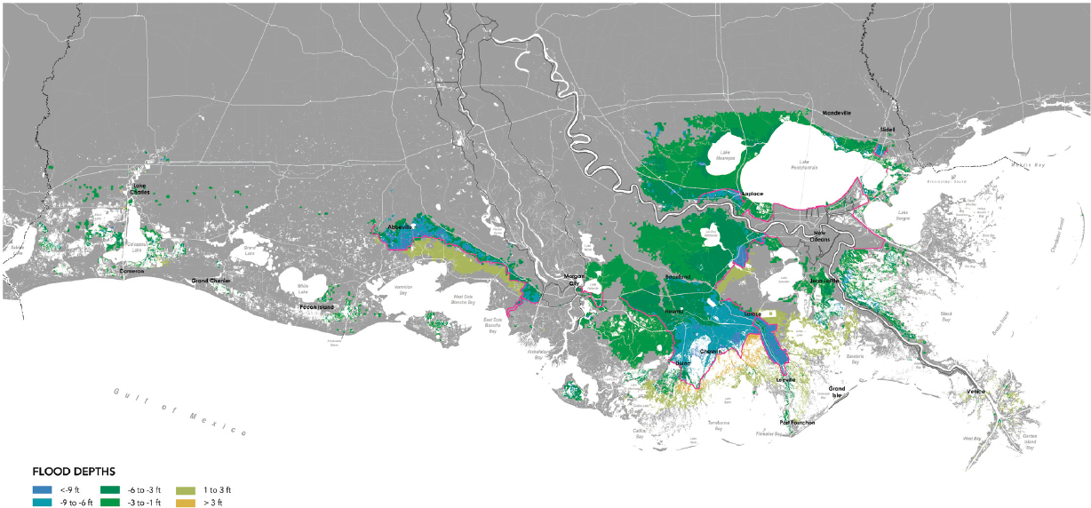
Levees, floodwalls, storm gates, and other infrastructure designed to reduce storm damage in specific geographic areas might impact storm surge and create damage in other nearby areas. When surge is prevented from entering the area landward of such a structure, the blocked water either then increases surge locally along the seaward side of the structure or will be redirected elsewhere. Often the response is for water to collect outside the area of protective infrastructure, increasing flood risks for homes and urban structures in that location. For example, the Louisiana 2017 Coastal Master Plan shows an increase in 100-year flood storm surges 50 years into the future for areas outside of the levees and other hard infrastructure (see Figure 2.6; LACPRA, 2017). Across the Gulf Coast, new levees are in various stages of planning, construction, and completion. Notable examples include the Morganza to the Gulf levee (USACE, 2013b), a 98 mile structure that is nearing completion of its initial alignment (but which has not yet been built to 100-year standards), and the extended Galveston area coastal barrier (often called the “Ike Dike”), which is in the proposal stage but has not yet been federally authorized or funded (USACE, 2015).
RIVERINE SEDIMENT TRANSPORT
The Mississippi River system is the dominant source of sediment for the Gulf system. It delivers about 136 × 106 metric tons of sediment per year (MT/yr), with about 88 × 106 MT/yr
coming through the main stem and 48 × 106 MT/yr through the Atchafalaya. The next largest sources of sediment are the Brazos (9 × 10⁶ MT/yr) and the Mobile (4.5 × 10⁶ MT/ yr) Rivers. The Colorado, Pascagoula, Pearl, Sabine, and Trinity Rivers each deliver about 1 × 10⁶ MT/yr of sediment (Allison et al., 2012). Coastal environments west of Mobile Bay, Alabama, are typically dominated by turbid waters, while coastal environments to its east typically feature clearer waters (Herrera-Silveira and Morales-Ojeda, 2009; Dzwonkowski et al., 2011). These differences stem, in part, from the nature of the river drainage basins. The Mississippi and Atchafalaya Rivers have a continental scale drainage basin that drains approximately 41 percent of the United States and contains diverse habitats including forests, farmland, arid lands, and cities; whereas many other rivers have regional-scale drainage basins with more homogenous land uses (Alexander et al., 2012). Because of their large absolute magnitude, the central Gulf rivers are important for both sediment and freshwater inputs (Horowitz et al., 2001; Turner et al., 2007; Allison et al., 2012; Lehrter et al., 2012; Fitzpatrick et al., 2017). Sediment budgets for the Mississippi River suggest that more than half of the sediment that enters at Tarbert Landing along the Mississippi–Louisiana border is trapped in the river channel or is transported to distributary channels near the river (Allison et al., 2012).
COASTAL SEDIMENT TRANSPORT AND HYDRODYNAMICS
Sediment sources within the Gulf of Mexico include offshore deposits from river discharge during periods of lower sea level and earlier periods in the Holocene Epoch, longshore drift from modern rivers, subsidence of coastal landforms, and biogenic production (Khalil et al., 2018). Sediments are available to be transported landward during normal coastal processes and during storm and overwash events and can be dredged for projects such as coastal restoration or mitigation of coastal erosion (Morang, 2006; Hickey et al., 2010; Wallace et al., 2010). These sediments are reworked by coastal hydrodynamics arising from tides, waves, and flooding during episodic coastal storms. The proportion of sediment trapped on coastal or deltaic plains matters greatly to the continued existence of coastal landforms and wetlands, but can be quite variable (sediment-retention efficiencies are commonly in the ~30 percent to 70 percent range; Blum and Roberts, 2009). Esposito et al. (2017) showed that within the Mississippi Delta, sediment-retention efficiencies can vary dramatically, with values of 5 percent to 30 percent near the open coast as opposed to greater than 75 percent in more inland settings.
Most of the Texas shoreline is characterized by a mixed tide regime, while in Alabama, Louisiana, and Mississippi the tides are diurnal. The west Florida shoreline has semi-diurnal tides in the northern part of the state and mixed tides in the southern part (Eleuterius and Beaugez, 1979). With rising sea levels, tides will be propagating on deeper water and tide components will change slightly. Pickering et al. (2017) project that, with
a 2 meter sea level rise and no shoreline retreat, tidal amplitudes will be up to 10 percent higher than today on the west coast of Florida and west of the Mississippi River Delta. With shoreline recession, the tidal amplitude changes will be less.
Waves are the principle driving force for coastal processes. The Gulf of Mexico is a low-energy coastline, with nonstorm wave heights on the order of 0.3 meters.4 Mean significant wave heights are larger in the eastern portions of the Gulf Coast (up to 2 meters), while maximum significant wave heights (associated with hurricanes) can reach up to 20 meters (Appendini et al., 2014). Results based on a 30-year hindcast (Appendini et al., 2014) indicate that the largest wave heights over this timeframe occurred offshore of Louisiana. Peak wave period values along the Gulf are generally 5 to 8 seconds, with the longer periods occurring in the eastern Gulf (Appendini et al., 2014). Panchang et al. (2013) showed, using a combination of wave modeling and buoy data, that 100-year return period values for deep water significant wave height on the order of 20 meters were appropriate. They also showed an increase in maximum annual significant wave height with time in the eastern part of the Gulf. Appendini et al. (2014) reached different conclusions in observable changes in wave height with time, with these discrepancies likely due to the use of small datasets in both studies (~50 and ~30 years, respectively).
EVOLUTION OF COASTAL LANDFORMS AND EMBAYMENTS
The geological record indicates that Gulf Coast bays and estuaries have a history of rapid and dramatic change in response to changes in sediment supply and RSL rise. Bay-head deltas, often found within coastal bays, are particularly sensitive to the balance between sea level rise and sediment input. When sediment input is sufficient, these deltas may grow despite rapid rates of RSL rise (e.g., Wellner et al., 2005; Anderson and Rodriguez, 2008). The Wax Lake (Louisiana) and Atchafalaya River Deltas, with their large sediment supplies, are among the few systems along the northern Gulf Coast that are likely to maintain or prograde during the next 50 years (LACPRA, 2017). Systems such as the Trinity River (within the Galveston Bay estuary complex) or Mobile River Deltas, with substantially less sediment supply, are likely to see land loss in the long term (Weston, 2014).
Many of the estuaries and bays of the Gulf Coast are fronted by sandy barrier islands and peninsulas. The remainder of the ocean coastline consists of marsh, bluff, and sandy mainland beaches. As sea level continues to rise, sandy coastline response will depend largely on the balance between the rates of sediment supply and RSL rise. When there is a sediment deficit, the shoreline will erode; when rates are balanced, shoreline position may remain stable over the long term. In the case of barrier island or sandy peninsula shorelines, when the rate of RSL rise outpaces rates of sediment supply, shoreline erosion can lead to
___________________
4 See https://coastal.er.usgs.gov/coastal-classification/process.html.
landform narrowing. If sea level rise continues to outpace rates of sediment supply, landward migration will likely occur when barrier islands or peninsulas become narrow enough for storms to impact their entire width (Leatherman, 1979). Migration is facilitated by overwash processes, which occur when the combination of tides, storm surge, and wave action brings the water level above the height of the frontal dune or berm (e.g., Sallenger, 2000). Overwash carries sand from the front of a barrier or peninsula to the interior of the landform. In this way, storms promote the maintenance of islands and sandy peninsulas by building them upward and moving them landward, thereby maintaining island elevation relative to sea level as sea level rises. Barriers constructed from muddy deltaic deposits require a greater amount of landward migration to liberate the same amount of sand, compared with locations where the substrate contains a higher proportion of sand (Moore et al., 2010). As a result, deltaic barriers are more vulnerable to disintegration than barriers underlain by sand (e.g., Moore et al., 2010; Otvos and Carter, 2013; Moore et al., 2014). In general, shoreline erosion rates are highest (up to 78.6 m/yr) in Louisiana along barrier island and headland shorelines associated with the Mississippi Delta (Morton et al., 2004, 2005). High rates of erosion are also prevalent along some of the Texas barrier islands and headlands (up to 25 m/yr; Morton et al., 2004; see also Gibeaut et al., 2000; Wallace and Anderson, 2013), although some long beach segments in Texas have accreted due to the convergence of net longshore drift and the presence of tidal inlets that have been stabilized by long jetties. In contrast, barrier islands in Mississippi are migrating laterally (Morton, 2008; Otvos and Carter, 2008) due to net alongshore sediment transport rates in this region.
Interactions between vegetation and sediment transport cause localized sand deposition in the presence of beach grasses, giving rise to coastal dunes. When present, dunes may provide protection to inland habitats and coastal infrastructure by reducing vulnerability to overwash and flooding during storms. For this reason, dunes are sometimes constructed as part of beach nourishment efforts designed to provide recreational beaches and storm protection. Other coastal management strategies, including seawall construction or groin emplacement, are sometimes undertaken in an attempt to maintain shoreline position. Some of these strategies have been supplanted by beach nourishment efforts (Morton et al., 2004), likely because hard structures do not allow for landward migration and can lead to narrower beaches as erosion continues. They also block the transfer of overwash sediment to the back-beach and back-barrier environments, with potentially detrimental long-term effects. Other residential and commercial infrastructure can also have this effect, as demonstrated by a field study of several sites in New Jersey affected by Hurricane Sandy, where buildings and a boardwalk blocked the delivery of up to 90 percent of overwash sand (Rogers et al., 2015). A companion modeling effort suggests this has the potential to prevent barriers from building upward and migrating landward, thus hastening island disintegration or drowning as sea level rises (Rogers et al., 2015).
Barrier islands are most able to maintain elevation above sea level when they retain their mobility. Competition among processes that form dunes or cause erosion determine the likelihood that dunes will recover and therefore maintain their height (Durán and Moore, 2015). It is the spreading, herbaceous species such as dune grasses, rather than rigid and tall woody growth form, that promote sediment accretion and increases in elevation (Feagin et al., 2015). If coastal management plans focus instead on sediment stabilization and the attainment of later stages of vegetation succession, such as maritime forest, the system as a whole would lose its natural resiliency. When the substrate is no longer mobile, early successional stages disappear and colonizer species that are tolerant of burial under sand become locally extinct. As a result, biodiversity and the sand-binding function that works against erosion are diminished (Martínez et al., 2004). Roman and Nordstrom (1988) concluded that human-induced sediment starvation has profound effects on barrier island vegetation, including a threshold shoreline erosion rate beyond which vegetation does not recover. The exact magnitude of this threshold may vary among barrier islands and depends on shoreline orientation, tidal range, storm frequency, and the ability of native plants to bind sand (Roman and Nordstrom, 1988; Tsoar, 2005).
Forecasting the future behavior of the physical coastal system is challenging, but there are several ways that projections of future coastline position and landform state can be done. The first is to use the historical behavior of the shoreline or marshes, such as erosion rates over decades or vegetation growth rates, and to extrapolate these rates into the future. These empirical data-driven models have been used for short-term changes (i.e., years), as well as long-term (even geological) timescales. This procedure assumes that “what’s past is prologue”; however, the recent past (i.e., the past 2,000 years) provides only a guide. For example, sea level is currently rising far faster than before, and so erosion rates in the future may be far higher than what has occurred in the past several thousand years.
Coastal evolution models, which simulate the evolution of the physical parts of the system, can be categorized by considering the domain across which a model operates and its underlying assumptions. For instance, coastal profile models only consider variations in water depth and topography in the onshore–offshore direction, either neglecting or parameterizing the effects of longshore variation (e.g., engineering models like SBEACH [e.g., Larson, 1990]; see Ruessink et al., 2007, for a review); while coastline models assume that the cross-shore beach profile is known and the same everywhere, but that the shoreline position can vary in the alongshore direction (e.g., Generalized Model for Simulating Shoreline Change [GENESIS; Hanson, 1989], Coastline Evolution Model [CEM; Ashton and Murray, 2006]; COastal Vector Evolution Model [COVE; Hurst et al., 2015], or see Dean and Dalrymple, 2002). Coastal area models allow the water depth to change in both the cross-shore and the alongshore direction (e.g., Delft3D [e.g., Lesser et al., 2004]; XBeach [Roelvink et al., 2009]); and landform models predict the evolution of barrier islands (e.g.,
Shoreline Translation Model [STM; Cowell et al., 1995], and those of Stolper et al., 2005; Masetti et al., 2008; and Lorenzo-Trueba and Ashton, 2014).
Coastal evolution models can also be classified according to whether they include all the relevant processes at the smallest scale practical (e.g., Delft3D) or include only those processes that are essential to capture realistic results (e.g., CEM, STM). Paola (2001) refers to these two types of models as reductionist or synthesist (i.e., reduced-complexity) models, while Bukulich (2013) uses the terms predictive and explanatory, respectively. Because synthesist models are sometimes used in a predictive sense, the Paola (2001) framework is used here. Reductionist models explicitly account for the bathymetric evolution via sediment transport formulations that directly link the mobilizing and transport of sediment to hydrodynamics. These models are often used for short-term events, such as bar migration or barrier island evolution, over timescales of days to weeks. The synthesist models are based on reduced-complexity formulations developed by choosing macroscale variables to drive the model, such as sediment transport rates, which inherently consider all the sediment transport modes and physics, but use simplified relationships instead of explicitly calculating them as a function of the overlying hydrodynamics. Even further abstractions are possible: Pape et al. (2010) use neural networks to compute the location and elevations of sand bars, migrating onshore and offshore. Reduced-complexity models can produce qualitatively reasonable behavior and some can be used to quickly explore parameter space within the context in support of engineering design, management planning, and decision making.
Ecological Processes
Gulf Coast ecosystems are highly diverse and provide essential services that are key in sustaining human and wildlife populations (de Groot et al., 2010). The dynamics, structure, and function of these ecosystems are broadly influenced by sharp environmental gradients that extend from the western to the eastern Gulf Coast, as well as substantial temporal variability that operates at different scales, ranging from episodic to seasonal to inter-annual. Human modifications of the coastal landscape, as well as climate change, also affect coastal ecosystems. Given the many interactions that can occur among natural environmental gradients, temporal variability, human coastal modifications, and changing climate, the impacts of such interactions on Gulf Coast ecosystems can be quite complex.
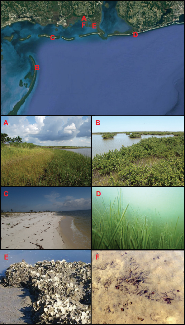
There are a multitude of ecological habitats along the Gulf Coast, including submerged sediments, wetlands, woodlands, and xeric dunes (see Figure 2.7). Wetlands fringe the coastline at the interface between land and the open waters of bays, lagoons, and the Gulf, comprising marshes and mangroves that are adapted to varying climate, seawater flooding, and salinity levels. With higher tolerance for cold weather, marshes tend to dominate in the northern Gulf Coast. Mangroves are currently more prominent along southern Florida and Texas, although there has been a recent northward expansion of red and black man-
groves in the Gulf Coast (Scheffel et al., 2013; Armitage et al., 2015), most likely due to climate warming and a decrease in the frequency and duration of freezes in the northern Gulf (Osland et al., 2013).
The nearshore submerged bottom landscape includes seagrass beds, oyster reefs, and bare sediment flats. Turtle grass (Thalassia testudinum) and manatee grass (Syringodium filiforme) are more typical in marine, high-salinity conditions, while shoal grass (Halodule wrightii) and widgeon grass (Ruppia maritima) tend to dominate in brackish, estuarine conditions (Handley et al., 2007). Seagrass beds tend to be less extensive and productive in the western Gulf Coast (i.e., west of Mobile Bay to Texas) (McDonald et al., 2016a), due to turbidity from greater amounts of suspended sediment discharge from rivers.
Oyster reefs constitute prominent and productive ecosystems in many locations along the Gulf Coast. The extent and productivity of oyster reefs are temporally and spatially variable (Kim et al., 2010) due to the highly dynamic nutrient, salinity, and hydrodynamic conditions along the coast. Bare sediment flats (populated with benthic microalgae) are another common feature of the benthic landscape, whether interspersed among seagrass beds and oyster reefs or extending across vast expanses. Sediment type and grain size depend on the proximity of river inputs, geology of the region, and hydrodynamic processes, resulting in highly variable sediment mosaics. Due to the greater sediment loads, muddier sediments are often found in the western Gulf Coast (Bianchi et al., 1998).
Barrier islands support other important habitats along the Gulf Coast. The development of vegetation and geomorphic features may be more tightly coupled on barrier islands than in nearly any other ecosystem (Oosting, 1954; Godfrey et al., 1979; Stallins and Parker, 2003; Feagin et al., 2005; Durán and Moore, 2015). Plant species found on barrier islands are adapted to a broad range of stressors, including drought, salt spray, and freshwater or saltwater flooding (Oosting, 1954; Lee and Ignaciuk, 1985; Shao et al., 1996). The degree of shelter from these stressors provided by dunes and other landforms, along with soil characteristics, depth to the water table, and groundwater salinity, determine the composition and spatial distribution of barrier island ecosystems (Hayden et al., 1995). Exposure to freshwater or saline water is determined by the influences of surface elevation and topography on precipitation, infiltration, and runoff, and the likelihood of tidal (i.e., saltwater) flooding (Hayden et al., 1995).
Gulf Coast ecosystems provide habitats for a wide variety of fauna, including shellfish, finfish, waterfowl, and marine mammals, many of which have commercial, recreational, or conservation interest. For instance, many fish species spend their early lives in wetlands, seagrass beds, oyster reefs, and sediment flats, and upon maturity migrate to deeper coastal waters, where they are harvested by commercial and recreational fishing (Beck et al., 2001). More than 90 percent of all commercial fish landings in the Gulf of Mexico are species that use coastal shallow systems during some portion of their life stage (Kennish, 1999; Lellis-Dibble et al., 2008). Coastal habitats are also hotspots for many resident and migra-
tory species of waterfowl, many of them protected or managed for hunting, including the endangered West Indian manatee (Trichechus manatus) (Hieb et al., 2017).
Seagrass beds, oyster reefs, wetlands, and barrier islands have the potential to reduce wave energy and help protect shorelines from erosion (Shepard et al., 2011). Wave-energy reduction also leads to enhanced sediment deposition, which contributes to shoreline accretion and protection (Manis et al., 2015). This is most evident when comparing storm impacts among coastlines with or without the protective effect of barrier islands, and also when comparing developed coastlands with no buffering vegetation in place to landscapes with buffering vegetation between the developed land and the coastline. Most often, storm impacts on land are more prominent with the absence of barrier islands and buffering vegetation (Woodruff et al., 2013; Sutton-Grier et al., 2015).
Coastal systems can also filter nutrients, preserving water quality. Through plant uptake and bacterial denitrification, wetlands can remove much of the nitrogen and phosphorus in land-derived runoff before it enters coastal waters (Sparks et al., 2015). Oyster reefs filter large amounts of particles out of the water column, enhancing water quality and clarity (Dame, 1993). Substantial nutrient filtration may also occur as terrestrial groundwater crosses the sediment before reaching the water column (Santos et al., 2012). Wetlands and seagrass beds can also act as large carbon sinks, since a portion of the carbon fixed through photosynthesis is stored as recalcitrant carbon (Macreadie et al., 2014; Hunter et al., 2015).
IMPACTS OF COASTAL DEVELOPMENT AND CLIMATE CHANGE ON ECOSYSTEM DYNAMICS AND FUNCTION
The rapid expansion of human populations throughout the Gulf Coast during the past century has caused large changes in the coastal landscape (Jackson et al., 2001). Natural vegetation, such as maritime forests and wetlands, has been replaced with farmlands, residential areas, industrial facilities, and other urban structures (Valiela, 2006). Urban development increases the area of impervious surfaces in the watershed, leading to larger surface runoff to coastal waters. Farmlands and residential areas contribute to increased nutrient loading from fertilizers and septic systems. As an example, nutrient inputs due to human development may vary five-fold across coastal watersheds in western Florida (Christiaen et al., 2016; Stutes et al., 2017). Canals also can contribute to saltwater intrusion and wetland loss (Penland et al., 2000).
Taken together, these human-derived inputs may lead to pollution in coastal waters. This can result in fish kills and other losses of marine life (Cloern, 2001) and may also increase the turbidity of coastal waters, which in combination with dredging and boating activities (e.g., damage caused by grounding and propellers), may cause losses of seagrass beds (Hauxwell et al., 2003; Anton et al., 2011). Several studies in the Gulf have documented large seagrass losses following intense nutrient loading (Anton et al., 2011;
Stutes et al., 2017). Such nutrient loading can also be exacerbated by boating activities (Trevathan-Tackett et al., 2018). Additionally, hydrological modifications in the watershed can drastically affect freshwater flow into coastal waters, leading to salinity and sediment alterations that are damaging to marine life. Among the deleterious impacts of hydrological alterations by humans in the Gulf are decreases in system productivity, wetland erosion, and habitat loss (Beck et al., 2011; Garrote-Moreno et al., 2014; Sharma et al., 2016c).
Resource exploitation constitutes another human impact on coastal ecosystems. Historically, many Gulf Coast fisheries were subject to overfishing; affected species included red drum, red snapper, boccacio, and several species of groupers (Coleman et al., 2000, 2004; Cowan et al., 2011). The 2007 reauthorization of the Magnuson–Stevens Fishery Conservation and Management Act required strictly enforced annual catch limits and rebuilding plans for overfished stocks in federal waters. As a result, red snapper, gag grouper, hogfish, greater amberjack, and gray triggerfish were considered rebuilt and removed from overfishing lists, and overfished stocks decreased from more than 33 percent to less than 5 percent (NOAA, 2017). Many commercially and recreationally fished species, however, do not have fishery management plans and are not assessed (NOAA, 2017). Moreover, rules for state-managed fisheries vary by state and may put some stocks at risk of overfishing.
Climate change is another driver of change in coastal ecosystems. Increasing temperatures are shifting the ranges of occurrence for several species—for example, tropical species such as mangroves (Osland et al., 2013), manatees (Pabody et al., 2009), and surgeon and parrot fishes (Fodrie et al., 2010) are expanding northward to the northern Gulf due to warmer temperatures. Acidification, through enhanced carbonate dissolution and depressed carbonate precipitation, can affect the health of calcifying organisms (Lemasson et al., 2017), which are abundant in many areas of the Gulf Coast. Altered rainfall patterns through changes in the salinity of coastal waters can cause large changes in coastal ecosystem structure (Christiaen et al., 2016). Increased frequency of extreme weather events, including major storms and hurricanes, may also substantially alter the dynamics of coastal ecosystems (Chen et al., 2017). Rising sea level will be a particularly important driver of coastal ecosystem change in the years ahead. High rates of RSL rise will lead to landward transgression of coastal wetlands, provided there is space available for upland wetland migration (i.e., no “coastal squeezing”). If sediment supply is not adequate to maintain their elevation, wetlands will drown (e.g., Morris et al., 2002; Kirwan et al., 2010; Jankowski et al., 2017). There is evidence that sediment discharge from major rivers is declining, which will likely lead to decreased marsh accretion rates. Coupled with increases in sea level rise, this decline will put marshes at increased risk of succumbing to rising seas in many areas of the northern Gulf (Weston, 2014).
Sea level rise will also affect barrier island ecosystems. With a rise in sea level, depth to the water table is reduced. This reduction creates wetter habitats at the expense of drier ones, and profoundly changes species diversity, community structure, and ecosystem function
(Ehrenfeld, 1990). Ehrenfeld (1990) noted that the effect of sea level rise on barrier island vegetation had not been studied. Over the nearly three decades since, and facilitated greatly by the development and increasing availability of the global positioning system (GPS) and light detection and ranging (LIDAR) technology for measuring surface elevation (Gibeaut et al., 2003), substantial gains have been made in understanding this phenomenon. Recent studies in the northern Gulf Coast show changes in the predominance of barrier island habitats from drier to wetter plant community types over the past several decades (Lucas and Carter, 2010; Jeter and Carter, 2016). Critically, these changes are highly sensitive to even decimeter-scale changes in island elevation above sea level (Lucas and Carter, 2013; Anderson et al., 2016; Funderburk et al., 2016).
EFFECTS OF STRATEGIC NATURAL RESOURCE CONSERVATION AND RESTORATION ON COASTAL ECOSYSTEMS
Humans can alter coastal ecosystems through development of the coastal landscape, exploitation of marine resources, and climate change, with potential consequences for the ecosystem services on which humans rely. These changes point to the need for policies to promote sustainable development, with a goal of achieving environmentally and economically “smart” growth that preserves ecosystem service provision. Smart growth policies aim for vibrant economies and healthy environments.
Part of effective management is strategic natural resource conservation. Coastal development will inevitably cause some loss of ecosystem function, which can be minimized by conserving ecosystem functional hotspots that can help regenerate resources where they have been lost or grow those resources elsewhere in the developed coastal environment (McDonald et al., 2016b). Functional hotspots can regenerate or implant resources through larval production and dispersal (Kim et al., 2010), export of plant seeds that will subsequently settle (Kendall et al., 2004), and migration of adult individuals that can then reproduce in the colonized areas (Sala et al., 2002). For instance, a fringing marsh buffer may preserve many of the ecosystem services present in the predevelopment environment, such as filtering runoff (e.g., Sparks et al., 2015), providing habitat for juvenile fish (Moody et al., 2013; McDonald et al., 2016b), and attenuating wave energy to reduce the impacts of storm surge on nearby communities (Roland and Douglas, 2005). The preservation and use of marsh buffers in green and hybrid infrastructure approaches has recently gained interest (Sutton-Grier et al., 2015). Engineering in ways that make use of nature’s ecosystem services and allow the natural system to adjust to changing conditions (e.g., by allowing marsh buffers to shift through time) is a main tenant of the emerging, innovative “Build with Nature” approach (e.g., de Vriend et al., 2015).
Coastal restoration, defined as the recovery of ecosystem structure and functions where they have been lost (Sparks et al., 2013; La Peyre et al., 2014), is another aspect of effective
management. Coastal restoration can be achieved through various strategies, including land building or ecosystem creation. Restoration activities are now standard in many environmental management plans at local, county, and regional levels. In Louisiana, marsh creation and barrier island restoration occur through dredging and sediment pipelining, and partial diversion of the Mississippi River is being used to restart natural land-building processes. Restoration of degraded ecosystems can, at least to some extent, improve environmental health and help promote resilience in developed coasts (Christiaen et al., 2013; Sharma et al., 2016b). Restoration actions also have the potential to help reduce coastal hazards, such as storm damage and nutrient pollution. However, the success of restoration efforts is highly variable, with some projects performing poorly and others performing quite well (Sparks et al., 2013).
THE HUMAN SYSTEM
Although the scientific challenges of projecting physical and ecological changes, such as sea level rise or marsh loss, over the next 10 to 200 years are formidable, and sizable uncertainty is expected, the scientific basis to predict most significant human processes with any degree of confidence on these timescales is lacking. To provide some context for the difficulty in understanding human processes over the long run, some of the changes in U.S. society and the Gulf Coast over the past century are discussed below.
By 1910, the U.S. population was 92.2 million,5 and the average U.S. life expectancy in 1910 was still far below modern levels, at 50.0 years.6 New Orleans was no longer among the 10 largest urban centers in the United States.7 The population of Florida was just 752,619 (compared with almost 21 million in 2017).8 There was a small but emerging oil and gas industry in the Gulf Coast (Theriot, 2014), the tourism industry was nascent, and the seafood industry was dramatically smaller. From 1950 to 2016, total commercial fishery landings in the Gulf Coast grew by a factor of three, from 258,841 MT to 791,433 MT.9 Over the same time span, total U.S. commercial fishery landings only grew by a factor of two. Gross domestic product per capita in the United States more than tripled, from $13,819 in 1950 to $51,338 in 2016 (in 2009 dollars).10
While quantitative changes in the size of the population, life expectancy, the U.S. economy, and Gulf Coast industries have been massive over the past century, qualitative changes in the nature of economic activity and how people live are arguably even more substantial
___________________
5 Data available at: https://www.census.gov/history/www/through_the_decades/fast_facts/1910_fast_facts.html.
6 Data available at: https://data.cdc.gov/NCHS/NCHS-Death-rates-and-life-expectancy-at-birth/w9j2-ggv5.
7 Data available at: https://www.census.gov/population/www/documentation/twps0027/tab07.txt.
8 Data available at: https://www.census.gov/dmd/www/resapport/states/florida.pdf and https://www.census.gov/quickfacts/FL.
9 Data available at: https://www.st.nmfs.noaa.gov/commercial-fisheries.
10 Data available at: https://fred.stlouisfed.org/series/A939RX0Q048SBEA.
and would have been impossible to predict. For example, the 20th century saw electrification of rural areas; widespread adoption of interior plumbing in rural areas; improvements in safe drinking water and sanitation in both rural and urban areas; widespread adoption of air conditioning (especially important for Gulf states); radical transformations in transportation systems with the emergence of aviation and the ubiquitous use of the automobile; major advances in medicine including the development of antibiotics; the emergence of the computer industry; and revolutions in both communications technology and media (Gordon, 2016). These examples are well known and are mentioned as a humble reminder of how difficult it is to anticipate what human society can or will achieve over something as large as a century timescale.
There is an argument, however, that many of the most important changes in the 20th century are unique to that time, and changes like them can never occur again. Economist Robert Gordon argued that growth in the U.S. economy, including the Gulf Coast, in the 20th century was largely attributable to qualitative changes and adoption of technologies, such as the ones described above, that improved human well-being in ways that cannot be repeated in the future (Gordon, 2016). Moreover, population growth in the United States has slowed substantially. It may not be entirely absurd to model human processes with the expectation that fundamental ways of living and basic construction, transportation, and infrastructure technologies will continue to be similar to today.
Many aspects of coastal storm damage or erosion reduction have remained unchanged over centuries. The basic design principles of these structures, such as breakwaters or jetties, date back centuries (e.g., Bruun, 1972; Charlier et al., 2005), though refinements and economies have been implemented in more recent times. Many other practices, such as beach nourishment, have been refined and documented, but the basic principles have remained the same. There have been some refinements—while streams have long been diverted, the scale at which diversions are being planned for land building in the Gulf is new (e.g., channels that carry 75,000 ft3/s; LACPRA, 2017).
While not all coastal changes will have direct day-to-day impacts, many of them will require some adjustment in management strategies and decision making. There are two primary pathways through which humans can respond to coastal change: they can adapt in place or they can migrate. Adapting in place might entail defensive capital expenditures (e.g., government and household spending on durable goods for climate change adaptation), restrictions on development, or simply choosing to do nothing. Relevant decisions may be made at the federal level (e.g., by the U.S. Army Corps of Engineers [USACE], the Federal Emergency Management Agency, the National Flood Insurance Program), the state level, locally at the town or municipal level (e.g., floating municipal bonds to fund a nourishment project), by individual households (e.g., installing revetments and bulkheads), or jointly by combinations of these groups. For example, the management of public flood risk has long focused on large-scale engineering projects, such as seawalls and levees, de-
signed and implemented by government agencies (Martin et al., 2010; USACE, 2014). An important Gulf Coast example is the Greater New Orleans Hurricane and Storm Damage Risk Reduction System, which is intended to prevent or reduce flooding from storm surge and waves from tropical cyclones in New Orleans. After the system catastrophically failed during Hurricane Katrina, USACE upgraded the system at a cost of approximately $14.5 billion (USACE, 2012). Much of the coastal flood control infrastructure built by USACE, in fact, is located in Louisiana and Texas (NRC, 2013; USACE, 2018).
Recently, there has been a shift toward a more integrated approach, including flood prevention and damage alleviation through small-scale measures taken by communities and households, such as flood-protection devices (e.g., flood vents), adaptive building uses, elevating homes, and flood insurance (McDaniels et al., 1999; Samuels et al., 2006; Interagency Climate Change Adaptation Task Force, 2011; LACPRA, 2017). The success of these programs depends on local residents’ willingness and ability to undertake those measures.
Adaptation Decision Making
Of the Gulf Coast states, only Louisiana and Texas have developed some version of a coastal adaptation plan. Louisiana recently finalized its third 50-year Coastal Master Plan (LACPRA, 2017), which provides information to stakeholders about the potential impacts of climate change and other drivers on Louisiana’s coastal areas. The Coastal Master Plan also identifies and prioritizes risk-reduction and mitigation and restoration projects. Louisiana’s coastal master planning process originates from the 2005 hurricane season, which included Hurricanes Katrina and Rita. The planning process is supported by one of the most sophisticated and integrated coastal simulation modeling efforts to date, with a series of linked models that allow the state to project future coastal changes, as well as potential mitigation and restoration scenarios.
Texas also recently issued its first Coastal Resiliency Master Plan, which provides information about the risks and impacts of climate change, as well as guidance for adaptation measures (Texas General Land Office, 2017). Both the Louisiana and Texas plans included the involvement of state and local constituents, as well as input from federal agencies, academic institutions, think tanks, and nongovernmental organizations. The effort in Louisiana invested significantly in policy analysis and public and stakeholder engagement (LACPRA, 2017; Speyrer and Gaharan, 2017). In addition, Florida, Louisiana, and Texas have adaptation planning activities at the local and the regional level.11 Florida has initiatives in the counties of Broward, Lee, Miami-Dade, Pinellas, and Sarasota, while Texas has initiatives in the Austin and Galveston-Houston areas. Although not all states have adaptation plans designed to address the impacts of climate change, all do have some level
___________________
11 Additional details can be found at: http://www.adaptationclearinghouse.org.
of coastal restoration activities that include elements of adaptation with implications for coastal resiliency (see NASEM, 2017b, for examples).
There is a growing understanding of how adaptation decisions are made. Individual adaptation measures have demonstrated ability to reduce flood damage (Kreibich et al., 2005; Schanze, 2008), yet relatively few people undertake adaptation measures voluntarily (Kunreuther, 1996; Wong-Parodi et al., 2017). It has been commonly assumed that individuals adapt as a result of high levels of perceived risk. A recent review, however, found that individuals’ willingness and ability to take such measures was unrelated to their perceptions of flood risk (Bubeck et al., 2012). Bubeck et al. (2012) suggest that taking steps to reduce risk (i.e., adaptation measures) is associated with decreasing levels of perceived personal risk, even if absolute risk remains unchanged. They also found less willingness to act among individuals who estimated higher costs for these measures, preferred public flood defense measures, or saw government as responsible (see also Kellens et al., 2013). Conversely, and echoing findings with respect to climate change perceptions (Lee et al., 2015), the review found greater stated willingness to adopt individual adaptation measures among people who viewed them as effective, who knew more about flooding hazards, and who had experienced flooding directly.
Other factors may also be important for the adoption of adaptation measures, in terms of actually being able to follow through with the intent to take action (see Box 2.2). For example, some studies found that those who have greater social support (e.g., someone to call if they need help) are more likely to take protective measures before, during, and after disasters (Riad et al., 1999; Kaniasty, 2012). Other studies found, however, that people who have greater levels of social support are more likely to take risks than they would otherwise, as they can treat that support like a safety net (Weber and Hsee, 1998; Hsee and Weber, 1999; Schneider et al., 2013). A recent study found that among individuals impacted by Hurricane Sandy, those who reported greater social support also reported greater tolerance for flood risks and greater confidence in community adaptation measures, suggesting an important but complex role of personal connections to collective resilience both keeping people in place and helping them survive there (Wong-Parodi et al., 2017). These findings are likely generalizable to the Gulf Coast, where individuals face similar threats due to extreme weather events and geography. For example, a study conducted in Mississippi found that individual and community characteristics make a difference with respect to overall resilience. Sherrieb et al. (2010) found that greater median household income, greater education, and greater employment were associated with greater overall community resilience.
Government and Household Spending for Climate Change Adaptation
Long-lasting community and individual investments are often made to mitigate potential harms from environmental change. These investments are known as durable goods or
defensive expenditures (e.g., Bunten and Kahn, 2017) and they tend to be large purchases. At the household level, a family may decide to invest in a truck with high ground clearance in order to avoid having their daily commute impacted by recurrent nuisance flooding. As another example, a household trying to mitigate flood risk may invest in interventions such as elevating the structure on pilings or installing hard, waterproof flooring instead of carpeting that is susceptible to mold. The Louisiana Coastal Master Plan specifically calls for these
nonstructural interventions based on projected future 100-year flood depths: waterproofing for 1 to 3 feet, raising structures for 3 to 14 feet, and acquisition of the property (abandonment) for more than 14 feet (LACPRA, 2017). Such decisions may enable households to continue living in coastal areas that experience moderate environmental changes. However, the ability of individual households to invest in structure mitigation or other adaptation measures will vary greatly with financial capacity and knowledge to take action, and also depends on the availability of incentives to support such investments.
Governments also invest in durable goods, often in the form of defensive engineering structures, to adapt to climate change. For example, a beachfront municipality may choose to build a seawall or nourish their beach to mitigate against storm damages. Household decisions on durable goods for adaptation can theoretically feed back on the natural system as well. A group of houses on a barrier island that are raised on pilings could allow more overwash to occur compared with the same houses that were not elevated (e.g., Rogers et al., 2015). Nevertheless, the effects of large-scale government defensive expenditures may create more pronounced feedbacks. For example, the Lake Borgne Surge Barrier constructed after Hurricane Katrina was expected to alter hydrodynamics in ways that are relevant to navigation (Martin et al., 2010).
Key drivers of defensive expenditures in the coastal zone are (1) federal-, state-, and locally-funded projects for maintaining channels, dredging ports, stabilizing shorelines with seawalls and beach nourishment, and building levees; (2) federal-, state-, and locally-subsidized flood insurance; (3) ecological restoration and land-creation projects that are funded with the explicit intent of reducing storm surge impacts and restoring coastal habitat (LACPRA, 2017); and (4) investments made in elevating or flood proofing at-risk buildings. For example, all the Gulf states have undertaken beach nourishment projects using federal funding.12 The extent to which federal, state, and local governments continue to contribute to these initiatives (and the potentially changing role of the private sector) is a key driver of which projects are built, development patterns in flood-prone areas, and how much local public finance will compensate by spending more of its local tax base on defensive investments. The possibility for important feedbacks implies that modeling the long-term evolution of the natural-human coastal system involves understanding when, where, to what extent, and in which forms defensive expenditures will occur (Smith et al., 2015; Gopalakirshnan et al., 2016).
Migration
The study of migration in response to coastal environmental change is a broad topic that touches on many academic fields, including demography (Hauer et al., 2016), anthro-
___________________
12 Details about the Program for the Study of Developed Shorelines are available at: http://beachnourishment.wcu.edu.
pology (Oliver-Smith, 1996), human geography (Colten et al., 2008; McLeman, 2017), history (Gutmann and Field, 2010), psychology (Thompson et al., 2017), political science (Aldrich, 2012), sociology (Myers et al., 2008; Meyer et al., 2018), and economics (Bunten and Kahn, 2017). These various fields approach the problem with different theories, data, and methodologies. For example, recent work in demography uses past empirical patterns of migration to extrapolate future patterns in response to sea level rise without modeling the causal drivers of migration explicitly (Hauer, 2017). In contrast, work in history and human geography usually relies on detailed case histories of natural hazards and other environmental changes (McLeman and Smit, 2006; Colten et al., 2008; Gutmann and Field, 2010). Political scientists and economists tend to use statistical methods that relate relocation and migration decisions to underlying structural drivers (Timmins, 2007; Bayer et al., 2009; Aldrich, 2012).
Despite methodological differences, there is some agreement on the factors that influence migration. People move or stay in response to economic opportunities, physical and economic ability to migrate, preferences for public goods (e.g., environmental amenities, schools, cultural amenities), and social capital (e.g., family, friends, civic engagement, religious organizations, ethnic and language ties). In general, communities with greater social vulnerability are less able to migrate away from increasingly hazardous areas (e.g., Myers et al., 2008). One such example is the Isle de Jean Charles, a small island in Terrebonne Parish, Louisiana. Located outside the Morganza to the Gulf levee, the island has seen a loss of more than 98 percent of the community’s land during the past 60 years, and only 320 acres of the island’s original 22,400 acres remain (HUD, 2017). Over the past half-century, as residents left (largely due to hurricane or flood damage) and access to work and schools became restricted due to regular flooding of the road connecting the island to the mainland, the number of residences (many now elevated and protected by ring levees) has dwindled by more than 60 percent (HUD, 2017). Based on the historic trends of land loss and future projections of sea level rise, as well as damage from storms, the island will most likely not be habitable in a few decades. The community has partnered with the State of Louisiana to look at resettlement options, which will be funded by a $48.3 million grant awarded by the U.S. Department of Housing and Urban Development (HUD, 2017).
Energy-Related Infrastructure
The energy sector is characterized by a complex and diverse set of infrastructure components (i.e., social, economic, environmental, built) within a multifaceted operational environment. Energy infrastructure provides essential fuel to a multitude of dependent economic sectors. In turn, energy infrastructure depends on other sectors such as transportation, information technology, communications, financial services, human and environmental resources, and government facilities (DHS-DOE, 2015). An illustration of these complex
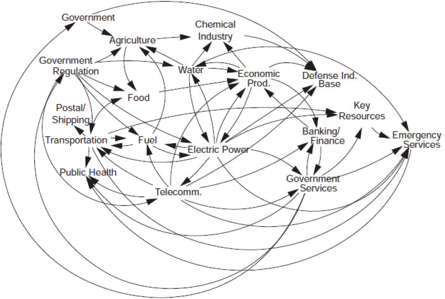
connections (see Figure 2.8) demonstrates that a disruption in a single component can generate disturbances to other sectors. While the scale of the disturbance depends on the size of the disruption, the interconnections can amplify the effects of a disruption, both in terms of severity and extent, causing large cascading failures (Wilbanks and Fernandez, 2013). For example, as part of a study commissioned to assess the impacts of hurricanes on energy infrastructure along the Gulf Coast, Dismukes (2011, p. v) concluded that “a disruption in the region’s infrastructure can have dramatic implications for not only domestic but also worldwide energy markets.”
The American Society of Civil Engineers (ASCE) grades the current state of national energy infrastructure as “D+” due to a combination of aging and increased vulnerability to storm impacts (ASCE, 2017). For example, 70 percent of U.S. high-pressure natural gas pipelines were installed before 1980 (DOT, 2011; DOE, 2015). Much of this oil and gas pipeline network is along the Gulf Coast.
The geology and geography of the Gulf Coast has influenced access to resources and the technologies used to exploit them (Priest, 2007). For more than half a century, major refineries and petrochemical plants have been in operation in the region, albeit with process and capacity modifications, reconditioning, and upgrades along the way. Much of the
fabrication and shipbuilding industry supporting oil and gas exploration is also more than a century old (BOEM, 2014). Age might not necessarily be directly indicative of vulnerability, but it is suggestive of older design practices that may be more vulnerable to changing future conditions. Infrastructure age often acts together with and may reinforce the effect of other factors such as design, maintenance, and operation in increasing the vulnerability of infrastructure to these various threats (DHS, 2010).
Additionally, the nation’s strategic petroleum reserve, which stores more than 700 million barrels of oil, is located along the Gulf Coast, tapping into salt domes and other subsurface features at points along the Texas and Louisiana coasts. The four storage facilities are at risk from storm surge caused by sea level rise and hurricanes (USACE, 2013a; Bradbury et al., 2015). A recent assessment by the U.S. Department of Energy noted that much of the Gulf Coast energy infrastructure is past its design life (DOE, 2016).
Storm surge flooding is the predominant hazard responsible for damages to energy infrastructure during hurricane events (NIST, 2006; Harris and Wilson, 2008). Storm surge flooding impacts to energy infrastructure have occurred in the past when perimeter berms around facilities, intended to provide protection, were overtopped by storm surge that exceeded the berm elevations. Flood protection of structures (e.g., by floodwalls, levees, and berms) or raising the height of existing structures and elevating critical equipment and control systems above design flood elevations have been the primary hardening efforts undertaken by the industry (DOE, 2010). In terms of resiliency, the industry has invested in preparedness activities such as maintaining minimum tank volumes, staging command vehicles and portable generators, coordinating priority restoration of services, and planning for employee evacuation exemption and reentry (DOE, 2010). Another issue is external metal corrosion from salt water, which is especially destructive to energy infrastructure (DOE, 2010). For example, between 1994 and 1999, of the major (i.e., resulting in injury, fatality, or more than $50,000 in property damage) hazardous liquid and natural gas transmission pipeline accidents, 65 percent and 35 percent, respectively, were due to external corrosion (Beavers and Thompson, 2006).
Besides the infrastructure components previously discussed, there is a large group of ancillary but equally critical oil and gas infrastructure that interacts with coastal physical processes. These include fabrication yards for various oil and gas infrastructure (e.g., see Dismukes, 2011); water intakes and outfalls; facilities for wastewater and stormwater detention; facilities for management, disposal, construction, and operation of diverse products and materials (Barr, 2014); seawalls, revetment, levees, dikes, and wetlands for protection of facilities (van der Meer et al., 2008; DOE, 2010); and groins, breakwaters, natural materials, and rock and concrete armor for protection of pipelines and pumping stations (NRC, 1994; The Nature Conservancy, 2013). Similar to the larger main production and processing units, these types of infrastructure are also vulnerable to risks associated with the changing coastal system, especially to impacts from subsidence and sea level rise via changes in their
relative elevation. In the central Gulf Coast region (between Galveston, Texas, and Mobile, Alabama), 72 percent of ports, 27 percent of major roads, and 9 percent of rail lines are at or below 4 feet of elevation (CCSP, 2008).
The Gulf Coast region is projected to remain an important contributor to crude oil and gas production in the world (API, 2017; EIA, 2018). In addition to increased core energy infrastructure that will be needed to support higher demand for oil and gas resources, supporting infrastructure critical to the supply chain along the Gulf Coast can also be expected to increase (API, 2017; ASCE, 2017). It is worth noting that recent analyses of energy cost and policy suggest that renewable energy growth across the United States is poised to continue (Breton and Moe, 2009; Lopez et al., 2012; NREL, 2016). While renewable energy resources and infrastructure are currently relatively scarce across the Gulf Coast, this could change over the next several decades.
In addition to energy infrastructure, the Gulf Coast is home to a wealth of other infrastructure assets, many of which could be affected by long-term physical changes to the coast. Some of this infrastructure is unique to the Gulf Coast and some is typical of many parts of the United States. Other critical infrastructure includes numerous ports; the Mississippi River, which is among the most important shipping pathways in the nation; and the Gulf Intracoastal Waterway, which connects inland waterways across the Gulf. The region has an extensive road and railway network, with some roads located at or near sea level. Some roads were built as causeways and others (e.g., the portion of LA-1 from Golden Meadow to Port Fourchon) were originally built as surface roads and have been elevated to provide an evacuation route from areas prone to flooding. An extensive inventory and description of Gulf Coast non-oil and gas infrastructure and its vulnerability to RSL rise and hurricane hazards is available (see CCSP, 2008; DOE, 2010, 2015; Wilbanks and Fernandez, 2013).
FEEDBACKS WITHIN THE COUPLED NATURAL-HUMAN SYSTEM
Especially important in feedbacks between the natural and human systems are the efforts undertaken to control coastal erosion and reduce flooding hazards through infrastructure approaches. Contemporary practice in coastal engineering for long-term and chronic coastal hazard mitigation includes consideration of traditional “gray” (hard) approaches (e.g., seawalls, bulkheads, groins) and “green” (nature-based) infrastructure (e.g., beaches, dunes, barrier islands, wetlands, mangroves, reefs), and the hybrid combination of the two, along with hazard mitigation investments in structure elevation, flood proofing, and buyouts. The design, performance, and impact of gray infrastructure in the coastal zone have been studied for some time (ASCE, 2003). Thus, the following discussion emphasizes green and hybrid infrastructure.
There is strong evidence that green infrastructure affects long-term coastal change—for example, by slowing chronic shoreline erosion and promoting sustainability of critical
habitats—and plays a role in episodic inundation- and wave-driven processes (e.g., Sutton-Grier et al., 2015; Narayan et al., 2016)—for example, by damping waves and wave run-up (e.g., Mendez and Losada, 2004; Irish et al., 2014). This is certainly true with existing in-place green infrastructure. As with any engineered coastal structure, green infrastructure may at once serve to reduce the hazard (long term or episodic) in the intended design area and potentially lead to an increase in hazard in other areas (e.g., Wamsley et al., 2009), an unintended consequence. Green and “Build with Nature” approaches (e.g., de Vriend, 2015) are more likely than gray infrastructure to provide the benefit of other ecosystem services, which makes them possible alternatives in new and ongoing coastal resilience initiatives.
Hybrid approaches incorporate nature-based approaches (e.g., oyster reef emplacement or dune construction) to enhance the effectiveness of gray infrastructure (Sharma et al., 2016a). Besides helping human-made features become more efficient, hybrid approaches can also help preserve ecosystem function and services. One example is the use of marshes, revetments, and breakwaters to reduce wave energy and enhance coastline resilience against storm surge. Marshes may further protect shorelines from erosion when conserved or restored alongside gray infrastructure and can provide ecosystem functions such as fisheries productivity and filtration. As with any engineered erosion-control measure, care needs to be taken to minimize erosive impacts downdrift. In Louisiana, a hybrid “multiple lines of defense” approach has emerged. This strategy posits that a combination of natural features (e.g., marshes, barrier islands), built infrastructure (e.g., levees, floodwalls), and nonstructural measures (e.g., evacuation planning) are necessary to reduce the impacts of storm surges (Lopez, 2009). This concept has been partially incorporated into the development of Louisiana’s Coastal Protection and Restoration Authority, which is responsible for coastal restoration and flood-risk reduction (LACPRA, 2017). See Box 2.3 for further discussion of feedbacks associated with gray and hybrid approaches.
Projecting the future evolution of the coupled natural-human system is particularly challenging as it requires both an understanding of, and the capability to simulate, the evolution of each system and its components, as well as the dynamics of feedbacks among all aspects of the system. There are recent examples of integrated simulation models used to project future conditions and support long-term coastal planning on the Gulf Coast that include consideration of feedbacks between the natural and human coastal systems. Specifically, models developed for Louisiana’s 2012 and 2017 Coastal Master Plan (LACPRA, 2012, 2017; Peyronnin et al., 2013; Brown et al., 2017) encode a series of relevant relationships among coastal processes. Key relationships include, for example, feedbacks between coastal eco-hydrology and wetland morphology (Meselhe et al., 2013; White et al., 2017) or morphology and coastal vegetation (Visser et al., 2013). Interactions include influences from these drivers on either key habitat types or on the propagation of storm surge and waves during tropical storm events (Peyronnin et al., 2013; Brown et al., 2017). This sys-
tem of models, however, does not yet consider dynamic feedbacks between the human and natural systems, except for the effects of specific restoration or risk-reduction projects considered for the master plan.
Coupled models can be perceived as oversimplifications of human agency and the human decision environment. The modeling approach, however, does not require distilling human decision making into a single deterministic driver. It can account, for example, for heterogeneous preferences and cultural influences (Smith et al., 2010), both optimizing and heuristic decision rules (Slott et al., 2008; Smith et al., 2009), heterogeneous information and beliefs (McNamara and Keeler, 2013), voter participation in political processes (Mullin et al., in press), and stochasticity (McNamara et al., 2015).
Although such models are still in their infancy, these tools provide a means for beginning to consider a range of different future scenarios. Some examples from various regions of the United States are listed in Box 2.4.
This page intentionally left blank.


