
A
The U.S. Geological Survey Water Mission Area
Since its inception after the passage of the Organic Act (43 U.S.C. § 31) in 1879, the U.S. Geological Survey (USGS) has collected and stored scientific information that is compiled into long-term continuous datasets accessible by federal, state, and local agencies, the private sector, and the public. In general, USGS does not have regulatory authority1 nor the authority to manage large tracts of public lands, construct infrastructure, or modify waterways or habitat.
The Water Mission Area (WMA) is one of seven interdisciplinary mission areas at USGS that emerged from a reorganization following the USGS 2007–2017 Water Science Strategy (Evenson et al., 2013). It covers scientific activities that involve collecting, assessing, and disseminating hydrological data and analyzing and researching hydrological systems. WMA is recognized for its high-quality, unbiased hydrologic data and scientific information. USGS is the world’s largest outlet of water data, integrating nearly 350 million sample results from more than 400 organizations.2 In addition to the millions of monthly users of online data, USGS delivers numerous scientific reports and journal articles annually.3 These
___________________
1 Following a 1954 Supreme Court ruling, USGS serves as River Master on the Delaware River, coordinating the release of water (among Delaware, New Jersey, New York, New York City, and Pennsylvania) to ensure sufficient water quantity to meet downstream flow objectives (https://webapps.usgs.gov/odrm).
2 Data provided to the committee by Drs. Nate Booth and Jordan Read, USGS WMA, at the committee’s third meeting on February 8, 2018.
3 Data provided to the committee by Drs. Nate Booth and Jordan Read, USGS WMA, at the committee’s third meeting on February 8, 2018.
peer-reviewed publications are highly regarded for their scientific integrity and lack of bias.
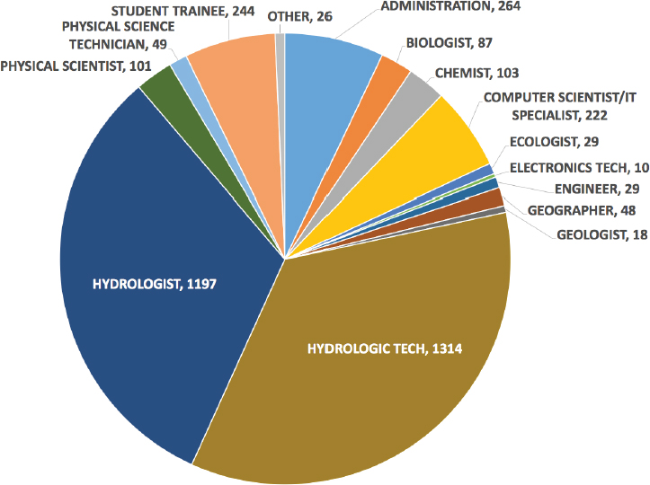
As of 2018, WMA has a workforce of approximately 3,750 staff at state and regional Water Science Centers (WSCs) and headquarters.4 More than 60 percent of WMA personnel are classified as hydrologists or hydrologic technicians (see Figure A.1), reflecting its current emphasis on collection and analysis of water resources data. Other important employment categories under the current organization include computer scientists, chemists, biologists, and ecologists, in addition to administrators. As the primary federal agency for water information, WMA monitors and assesses the quantity and characteristics of the nation’s water resources, investigates the sources and behavior of natural solutes and contaminants in water (often with state cooperators and partners), and develops practical tools to improve understanding and management of this resource.
___________________
4 Data provided to the committee by Dr. Don Cline, USGS Associate Director for Water, at the committee’s first meeting on September 18, 2017.
WMA personnel respond to strategic national priorities set by headquarters as well as regional, state, and local needs determined largely by collaborative partners. WMA maintains a physical presence across the nation, with facilities in each state as well as in Puerto Rico, the U.S. Virgin Islands, and the U.S.-affiliated Pacific Islands. Most scientific work is managed through state or regional WSCs. Science support for these centers comes from a series of USGS laboratory and technical facilities, such as the National Water Quality Laboratory in Lakewood, Colorado, and the Hydrologic Instrumentation Facility at the Stennis Space Center in Mississippi. These facilities help USGS personnel and cooperators conduct studies and analyze water quantity and quality issues throughout the nation, its territories and the U.S.-associated Pacific Islands by providing broad analytical services, assisting in processing samples, providing instrumentation and training for deployment and maintenance of sensors, as well as processing data and making them available to the public. This operational structure, partially determined by federal authority and through U.S. congressional appropriations, helps to foster interaction with state, regional, and local partners and ensures that USGS provides focused and relevant national scientific expertise to states and localities5 (Brooks, 2001). This cooperation helps USGS maintain awareness of water science and resources challenges across the United States and ensures that national missions and goals remain aligned with emerging trends (Blanchard, 1999).6
As noted in Chapter 1, WMA’s strategy is to provide water resource monitoring, assessment, modeling, and research data and tools that are relevant to:
- Preserving the quality and quantity of the nation’s water resources;
- Balancing water quantity and quality in relation to potential conflicting uses;
- Understanding, predicting, and mitigating water-related hazards; and
- Quantifying the vulnerability of human populations and ecosystems to water shortages, surpluses, and degradation of water quality.
The 2013 USGS Water Science Strategy document (Evenson et al., 2013) reframes the above national objectives into five operational goals:
___________________
5 See https://water.usgs.gov/coop/about/CWP.science.priorities.pdf; accessed September 17, 2018.
6 See https://water.usgs.gov/coop/about/CWP.briefing.sheet.pdf; accessed September 17, 2018.
- Provide society with the high-quality information it needs regarding the amount and quality of water in all components of the water cycle at high temporal and spatial resolution, nationwide.
- Advance understanding of processes that determine water availability.
- Predict changes in the quantity and quality of water resources in response to changing climate, population, land-use, and management scenarios.
- Anticipate and respond to water-related emergencies and conflicts.
- Deliver timely hydrologic data, analyses, and decision-support tools seamlessly across the nation to support water-resources decisions.7
WMA’s various programs, subprograms, divisions, and WSCs work to achieve these five stated goals through observing the water cycle, improving understanding of critical processes, predicting changes in water availability and quality over time, and delivering water science data and information to the federal, state, and local agencies, the public, tribes, and industry to support informed decision-making. WMA activities related to each of the five goals are briefly summarized below. In addition, a sixth goal that relates to cross-cutting issues with other USGS mission areas is discussed.
WMA CAPABILITIES
Observing the Water Cycle
USGS water programs are perhaps best known for their long history of measuring and monitoring streamflows, surface-water and groundwater levels, and water quality. Through networks consisting of streamgages (some with continuous water-quality monitoring stations), precipitation stations, and groundwater observation wells, WMA attempts to quantify water availability and quality across the United States. At present, USGS has about 8,200 streamgages located across the country. Data collected at each site vary based on federal, state, and regional requirements. Additionally, USGS maintains 1,900 continuous water-quality sampling stations, with selected variables recorded every 15 minutes.8 Local data collection intervals vary depending on site conditions. Temperature, conductance, pH, dissolved oxygen, turbidity, nitrates, and chlorophyll are some of the parameters measured.
USGS or its cooperators collect intermittent data from about 17,000 groundwater observation wells across the country. The actual number of
___________________
7 Data provided to the committee by Dr. Don Cline, Associate Director for Water, at the committee’s first meeting on September 18, 2017.
8 Data provided by Dr. Don Cline and Robert Moore, USGS WMA.
wells can vary from year to year, based on access. About 1,800 of these provide real-time monitoring of water levels; these data are all considered as part of the active groundwater-level network.9,10 About 1,000 of these wells provide daily water level measurements. The remainder of these observation well data are collected periodically, often by cooperators at state agencies. USGS awards up to $2 million annually11 in cooperative agreements to support participation in the National Ground-Water Monitoring Network (NGWMN). Since this program began in 2015, 30 agencies have either completed the process of becoming a data provider to the network, have an ongoing project to become a data provider, or have a project to enhance NGWMN sites. USGS maintains about 250 precipitation-monitoring stations. Often these data are collected for local municipalities and help augment National Weather Service or U.S. Army Corps of Engineers (USACE) networks. The networks are maintained and operated through various programs funded through federal, state, and local agencies. For example, the vast majority of streamgages in the USGS network are funded jointly by USGS and state, regional, local, and tribal partners. These streamgages provide data beneficial to localities and therefore require matching funds by local partners. While a majority of streamgages are cooperatively funded, approximately 15 percent of U.S. streamgages are considered essential due to their importance in fulfilling various missions within USGS or meeting strategic long-term federal responsibilities within other agencies and are funded by USGS without joint cooperator funding under the Federal Priority Streamgages designation administered by the Groundwater and Streamflow Information Program (and its predecessor the National Streamflow Information Program) (DOI, 2018). While this designation applies to 3,460 streamgages, in 2017, only 1,176 gages were fully funded by USGS, while the remaining 2,284 were jointly funded by USGS and partners (DOI, 2018).
In addition to hydrologic and observational networks, USGS collaborates with various national research laboratories across the United States in various programs, including those at USGS facilities such as the National Water Quality Laboratory and the Hydrologic Instrumentation Facility. Numerous state and regional agencies and universities are engaged as collaborators to facilitate monitoring, consistent data collection, and quality assurance procedures. The USGS National Water-Use Science Project (formerly the National Water-Use Information Program) assembles and distributes water-use data. This program, using data primarily supplied
___________________
9 Data provided by Dr. Don Cline and Robert Moore, USGS WMA.
10 See https://groundwaterwatch.usgs.gov/default.asp; accessed September 17, 2018.
11 See https://www.usgs.gov/news/usgs-seeks-national-ground-water-monitoring-network-proposals-2018; accessed July 30, 2018.
by states and cooperators, analyzes the sources, uses, and fate of water at local, state, and national scales, documents water-use trends, and prepares national water-use summaries on a 5-year basis. These data are organized by water use categories. A related research program, the National Water Census, develops analytical tools and explores links between water use and water quality. This program distributes watershed- and county-based water budget data online through the National Water Census Data Portal.
USGS observations involve all aspects of the water cycle. WMA personnel develop, evaluate, and apply new measurement and characterization techniques for gathering water resource information. Airborne, surface, and borehole geophysical techniques help characterize subsurface geology and aquifer geometry to enhance groundwater studies. Chemical and isotopic tracing and fingerprinting techniques are being applied to water quality and biogeochemical investigations. Innovative equipment and sensors are used to monitor surface water flows and quality.
Understanding Critical Processes
WMA advances understanding of processes affecting water quality and availability throughout the water cycle to inform decision-making through its own research and through collaborations with federal and nonfederal partners as well as through the administration of grants. Active research activities include investigations of the water cycle, hydrodynamics, hydrological-ecological interactions, water resources availability, and hydrogeophysics. Many of these investigations are carried out in WSCs through the USGS Cooperative Matching Funds (Coop) Program.
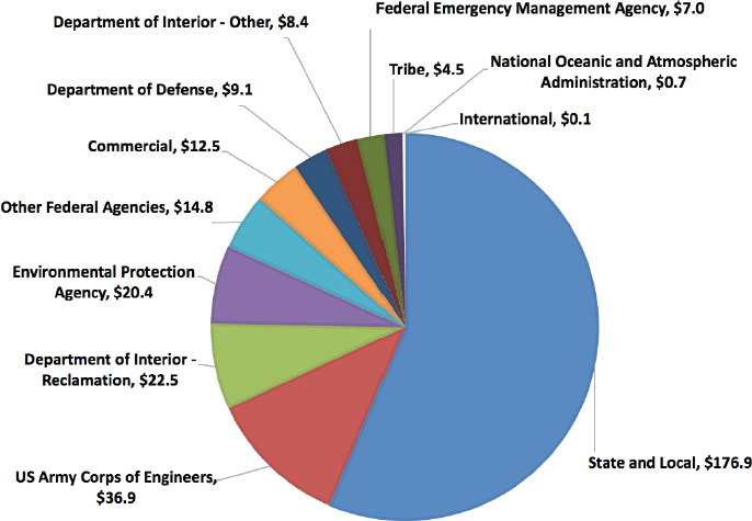
One of the most important programs to WMA, the Coop Program, supports applied science through collaboration between WSCs and nonfederal agencies within each state. Under the Coop Program, federal funds are matched by nearly 1,600 local, municipal, county, state, regional, and tribal partners to conduct water science and research activities across the United States and its territories and protectorates. This state and local funding represents more than 50 percent of the $314 million reimbursable budget of the WMA (see Figure A.2), a large percentage of the total FY2017 $529 million budget, and has become a major driver of USGS programming.12 By using consistent procedures and standards, WMA ensures that data collected from the Coop Program are consistent across all of the regions and available within USGS databases for use at local, state, regional, and national scales. These collaborations help keep the work of WMA focused on practical needs of each county, state, and regional part-
___________________
12 Data provided to the committee by Dr. Don Cline, Associate Director for Water, at the committee’s first meeting on September 18, 2017.
ner, while informing and providing visibility to emerging issues. A majority of the streamgages in the network are funded through the Coop Program.13 Likewise, the program helps manage data from networks of groundwater monitoring wells in most states.
In most WSCs, the Coop Program supports multiple applied water science projects under the broad umbrella of understanding the water cycle. These studies are usually focused on local or regional needs and often have significant field components. Projects range in scope from large and long term, such as integrated eco-hydrologic assessments of the California Bay Delta system (Mueller-Solger, personal communication14), to smaller and short term, such as an evaluation of the water supply for a state-run fish hatchery in Wisconsin (Dunning et al., 2017). The Coop Program allows cooperators to address local problems while tapping into national expertise, capabilities, and equipment that might not otherwise be available. The program also keeps the regional and local WSCs in touch with local and
___________________
13 See https://water.usgs.gov/coop/about/monitors.html; accessed September 17, 2018.
14 Communication during committee’s open session in San Diego, California, on November 30, 2017, with Anke Mueller-Solger, U.S. Geological Survey.
regional issues and fosters beneficial technology transfer between USGS scientists and local experts.
An important connection between USGS water programs and university water science programs is through the National Institutes for Water Resources (NIWR). There are 54 water resources research institutes, which were established through the Water Resources Research Act of 1964 and are generally co-located within land-grant universities across the United States and its territories.15 The water resources research institutes distribute annual base grants, coordination grants, and national competitive grants, as well as student internship opportunities. Coordinated by USGS through NIWR, these institutes have historically received modest base funding from WMA, which is then leveraged significantly by the universities and through extramural grants obtained by university scientists and students through the State Water Research Grant Program; while the National Water Research Grants Program funds research of national importance.16 The institutes serve as local hubs for promoting technology and information transfer between university and USGS scientists, and the academic connections are critical for helping train the next generation of water scientists and engineers, some of whom go on to have careers within USGS.
In addition to the Coop Program, WSCs, and NIWR, WMA collaborates extensively with federal agencies on a wide variety of national projects and science related activities. From collaboration with the National Oceanic and Atmospheric Administration’s (NOAA’s) National Weather Service on data related to flood forecasts, coordination with the Federal Emergency Management Agency (FEMA) on disaster response or making data readily available for use by other agencies, USGS works extensively to assist federal agencies. These collaborations provide reimbursable income to USGS, helping to sustain its programs and workforce beyond its own federal appropriations. While many examples can be cited, a few are provided for context. In a major collaborative effort, USGS is working with NOAA and USACE to develop a National Water Model in a modeling-method integration effort to forecast streamflow over the continental United States in near real-time (see Box 2.1).17 USGS is also leading the development of the subsurface hydrology model in the National Water Model. Similarly, USGS and the U.S. Environmental Protection Agency (EPA) collaborated to develop a new surface-water modeling tool, called the Surface Water Toolbox, designed to be of particular use to regulators and watershed managers. It combines USGS’s Surface-Water Statistics software, used to enable
___________________
15 See https://water.usgs.gov/wrri/index.php; accessed September 17, 2018.
16 See https://water.usgs.gov/wrri/2014-NIWR-USGS-Fact-Sheet.pdf; accessed September 17, 2018.
17 See http://water.noaa.gov/about/nwm; accessed September 17, 2018.
statistical analysis of water time-series data, with the EPA’s DFLOW tool, used for estimating streamflows for low-flow analysis and water quality standards. USGS research and partnerships with federal, state, and local collaborators provides innumerable benefits to USGS, its cooperators, and the nation. These investigations improve understanding of processes surrounding water quantity and quality and inform decisionmakers while providing publicly accessible data.
Predicting Changes in Water Availability and Quality
One of the most critical components of the work of USGS is to provide data, information and tools for predicting long- and short-term changes to the water cycle for federal, state, regional, tribal, and local stakeholders and managers. Data and observations are transferred in publications, usable data science products, Web communications, and decision-support tools, which serve as important resources for water managers and policymakers for predicting future outcomes. USGS has developed numerous hydrologic and geochemical simulation models that are used to predict changes in hydrologic systems of given various stresses, and these products are useful in determining potential water quantity and quality impacts to surface and groundwater.
While numerous USGS models exist, three examples that are important to water resources managers and scientists are the SPARROW (Spatially Referenced Regressions on Watershed attributes) models, MODFLOW models, and the National Hydrologic Model. SPARROW models provide statistical estimates about the origin, transportation, and fate of nutrients and contaminants moving through watersheds, linking monitoring data to watershed hydrology.18 These models help managers determine how to reduce contaminant loads, predict water quality changes, design management strategies, and change policies. Similarly, the MODFLOW family of groundwater flow codes allows simulation and prediction of groundwater conditions as well as groundwater–surface water interactions.19 USGS also leads integrative modeling efforts, such as the National Hydrologic Model, in addition to providing foundational support to the development of the National Water Model led by the National Weather Service (see Box 2.1). The National Hydrologic Model is a continental U.S.-scale application of the USGS Precipitation-Runoff Modeling System on aggregated National Hydrography Dataset Plus (NHDPlus)20 polygon Hydrologic Response
___________________
18 See https://water.usgs.gov/nawqa/sparrow; accessed September 17, 2018.
19 See https://water.usgs.gov/ogw/modflow; accessed September 17, 2018.
20 See https://www.epa.gov/waterdata/nhdplus-national-hydrography-dataset-plus; accessed October 25, 2018.
Units (Regan et al., 2018). It is supported by the USGS National Geo Data Portal and provides to the public calibrated model parameters, readily usable by local, state, and regional water managers. Such tools provide invaluable resources for the private and public sectors to use USGS data and science to make informed decisions about water resources.
Delivering Water Science Data and Information
USGS is known for long-term storage of historical water data and for delivery of real-time data. WMA is responsible for data collection, quality assurance, and dissemination of data and information on water activities across the United States. USGS collects large amounts of data on the water cycle, generally within the broad categories of surface water and groundwater. “Super” gages (also known as “sentry” gages), which represent a small subset of streamgages, can measure data such as temperature, specific conductance, pH, nutrients (e.g., nitrogen, phosphorous), and sediment concentration (Shoda et al., 2015). Such continuous water-quality gages allow USGS to monitor streamflow conditions under average conditions as well as under storm or accidental spill situations. Data on pesticides, emerging contaminants, and volatile organic compounds are collected as part of the National Water-Quality Assessment (NAWQA) Project. In addition to critical data collection around surface water and groundwater quantity and quality, WMA provides information on flood inundation; acid rain, atmospheric deposition, and precipitation; chemistry; biological communities and physical habitat; reservoir sedimentation; and water-use data.
Much of these data are accessible through the National Water Information System (NWIS) database containing water data collected at more than 1.5 million sites around the United States and at some border and territorial sites.21 These data provide opportunities to view changes in water availability and quality overtime. NWIS stores numerous types of data; however, local WSCs may need to be contacted to obtain some information. In 2017, USGS real-time water data was requested 120 million times per month.22 In addition to the NWIS, WMA houses relevant data through various sites, such as Water Watch,23 Water Quality Watch,24 Groundwater Watch,25 and WaterNow.26 Numerous other sites accessible through the WMA website allow academics, scientists, managers, and other users to readily access
___________________
21 See https://waterdata.usgs.gov/nwis; accessed September 17, 2018.
22 Communication during committee’s open session in San Diego, California, on November 30, 2017, with Dianna Crilley, U.S. Geological Survey.
23 See https://waterwatch.usgs.gov/index.php; accessed September 17, 2018.
24 See https://waterwatch.usgs.gov/wqwatch; accessed September 17, 2018.
25 See https://groundwaterwatch.usgs.gov; accessed September 17, 2018.
26 See https://water.usgs.gov/waternow; accessed September 17, 2018.
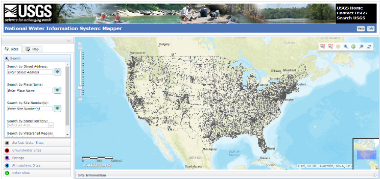
data for use in academic and scientific study, emergency management, and decision-making. The processes of data acquisition, storage, and delivery are constantly evolving as instrumentation and sensors now collect more data more rapidly than ever before and as stakeholders demand real-time, open-source data delivered. Consequently, the NWIS system has evolved from a relatively static database in the 1970s to a constantly updated real-time delivery system today (see Figure A.3). Understanding, interpreting, and delivering this vast data collection has included advances in data informatics and data visualization, which represent new frontiers for WMA.
Cross-Cutting Science with Other USGS Mission Areas
Because water science is a fundamental part of most Earth system studies, WMA programs and activities are substantially linked to the work of other USGS mission areas (Evenson et al., 2013). These cross-cutting links include:
- Core Science Systems, which focuses on advances in modeling, data acquisition and manipulation, visualization tools, and advances in Earth-science data collection such as lidar, the National Hydrography Dataset, and remote sensing;
- Ecosystems, linking water resources to ecosystem health and stability;
- Energy and Minerals, exploring relationships between water-resources questions and the energy cycle and the nation’s mineral resources;
- Environmental Health Science, coordinating research on water resources related to human health, emerging contaminants, pathogens in the environment, and related issues;
- Land Resources, in which WMA has roles in the National Water Census, predicting future changes in floods and droughts, and long-term assessments of changing water quality through NAWQA; and
- Natural Hazards, in which WMA has important roles in helping protect the safety, security, and well-being of the nation by collecting data and carrying out research related to flooding, landslides, erosion, debris flows, and other hazards.
STAKEHOLDER ENGAGEMENT
Over the course of this study, the committee heard input from numerous USGS cooperators, stakeholders, collaborators, and data users, which included federal and state agency staff, state geological surveys, university and laboratory researchers, and nongovernmental organizations (see Appendix B for a list of presenters and attendees of information-gathering sessions). While USGS cooperators and data users expressed many opinions relevant to their regional or local needs, a majority commended USGS for its extensive hydrologic monitoring network, stakeholder collaborations with USGS scientists on numerous investigations, and much of the cooperative work that WMA does with local, state, and regional agencies. Overwhelmingly, state and nongovernmental stakeholders praised USGS for the streamgage network and its critical importance not just federally, but for localities, states, and regions. These stakeholders encouraged USGS to continue to strategically maintain or expand this network, when feasible.
Federal Engagement
Numerous federal stakeholders repeatedly stated the importance of datasets maintained by USGS and the importance of this information as a foundation for their own programs, decision-making, and disaster and emergency response efforts. Federal staff across various agencies (e.g., EPA, FEMA, NOAA, U.S. Department of the Interior [DOI], USACE) stated the need to ensure the integrity and continuity of these data to better inform their own decision-making. For example, USGS provides water-use accounting data to the U.S. Bureau of Reclamation for dam
releases, provides water-quality assistance to tribes, and provides a more informed understanding of land-use change across the United States. The streamgage network, storm-surge sensors, and hydrographic maps provide federal agencies within DOI with the ability to manage river and aquifer basins and to respond to emergencies.
Elsewhere within the federal government, staff value the collaborations with USGS on model development with agencies (i.e., EPA, the National Aeronautics and Space Administration [NASA], NOAA, the U.S. Department of Energy), data for water releases with USACE, and emergency response with FEMA. Decision-makers reiterated a continued need to look to USGS to answer science questions regarding the decision-making tradeoffs that are implicit in water decision-making, such as mid- and long-range water prediction capabilities and the development of new hydrologic models. Stakeholders urged USGS to increase its spatial and temporal coverage of the hydrologic network to improve decision-making.
State-Level Engagement
At the state level, stakeholders noted USGS’s hydrologic monitoring network and datasets and reiterated their continued need for basic waterdata collection facilitated by USGS. Similar to numerous federal staff, state agency staff value existing USGS datasets and expressed interest in expansion of the existing monitoring networks. The committee heard from a number of state agency representatives about issues that impact their ability to work with USGS, including cooperator limitations, a concern about base funding for the streamgage network, and a perceived pressure that USGS needs to work on any project with funding, whether within its purview or not. There was also a sense that USGS could improve identification of roles and partnerships with other federal agencies.
Other Stakeholders
The committee heard input from numerous local and regional stakeholders who interact with USGS in a variety of capacities. These stakeholders suggested that USGS focus on the core competencies of:
- Hydrologic data collection and the methods development that the data collection entails;
- Conversion of data into useful information;
- Long-term studies of hydrologic processes; and
- Development and application of models to gain insight into processes and to evaluate past or potential scenarios.
The academic community expressed support for USGS and its collaborations with the community through interactions on scientific research. A number of stakeholders believe the USGS does an effective job within the public–private partnership realm. These interactions have increased the understanding within the field and also brought in external funding for research topics. However, there is concern that funding pressures could lead to the removal of monitoring networks in smaller watersheds, despite their importance to long-term land use change in larger basins. Other stakeholders expressed a desire for USGS to decrease the amount of time to process and make data publicly available. Stakeholders at all levels encouraged USGS to work to improve model integration between surface water and groundwater, emphasizing how beneficial this would be in their own work.


