
4
Innovations and Solutions in Sustainability Science for Drylands Areas
This workshop session featured three presentations and discussions of groundbreaking applications and strategies being developed for use in the transboundary region: the Land-Potential Knowledge System, the National Integrated Drought Information System, and the North American Development Bank.
LAND-POTENTIAL KNOWLEDGE SYSTEM
Jeff Herrick (U.S. Department of Agriculture [USDA]) described the Land-Potential Knowledge System, a mobile application sponsored by USDA and the U.S. Agency for International Development (USAID). The application’s chief function is obtaining a point-specific determination of sustainable land use, based on user inputs, cell phones and cloud-based databases, and algorithms for land use planning and management. Simply put, Herrick said, the system determines what sustainable use looks like for a given target area on the planet. It provides alternative uses, such as rangeland monitoring and assessment and remote sensing calibration. In addition, new functionalities, such as soil health monitoring and land type cross-referencing, are scheduled to be added in late 2018 and early 2019. Ultimately, he said that the application will help maximize land use potential and return on investment using targeted management inputs. At present, the system’s application’s database is open to the public. Herrick said the plan for the future is to provide user access to large databanks that can be used to interpret data in a way that best suits users’ needs.
Herrick provided examples of how the application can pinpoint minor
differences in soil composition even in areas with seemingly similar conditions. He said the application is user friendly and does not require expertise in soil characterization. He walked the group through a demonstration and highlighted the different reporting fields and functions, including areas for information on weather, location (if GPS [Global Positioning System] is enabled on the cell phone or tablet), flooding conditions, current land use, and questions about the look and feel of the soil. The application also allows users to upload photos, describe the vegetation patterns, and add written descriptions. All of these functionalities are available without an Internet connection. Herrick said the application continues to evolve and, as he mentioned, in late 2018 it will be able to provide global soil data, as well as the automatic determination of the Land Capability Classification System, and promote the exchange of knowledge across countries.
Herrick briefly discussed the history of the project, starting with the creation of ARIDnet (Assessment, Research, and Integration of Desertification network) in 2004. The project identified the need for rapid access to locally relevant climate and soil knowledge. At the Ecological Society of America Conference in 2006, he and a colleague presented a strategy for global ecological research as a means to mitigate environmental degradation.1 In 2013, they received funding from USAID to develop the pilot. Herrick said that one of the major strengths of this project is its ability to maximize collaboration between organizations with similar interests, and he reported that the list of participating organizations is steadily growing. Herrick believes that analyzing and improving how people handle systems will require creating common data and knowledge bases that are easily accessible and would incentivize researchers to both use and contribute to them.
THE NATIONAL INTEGRATED DROUGHT INFORMATION SYSTEM
Elizabeth Weight (U.S. National Oceanic and Atmospheric Administration [NOAA]) noted that drought had been a prominent topic in workshop discussions. Drought is a complex problem with several different definitions and no one simple solution. She said that drought is usually categorized based on four common measurements, three of which measure drought as a physical phenomenon: meteorological drought, which is a precipitation deficit; hydrological drought, which occurs when low water supply affects streams, reservoirs, and groundwater levels; and agricultural drought, which occurs when crops are affected. The fourth category measures drought in
___________________
1 Herrick, J.E., and Sarukhán, J. (2007). A strategy for ecology in an era of globalization. Frontiers in Ecology and the Environment, 55(4), 172–181.
relation to supply and demand: when the demand for water—for example, with increasing population and per capita consumption—is higher than available water supplies.
Weight said that, more recently, an additional definition of drought has emerged—ecological drought, which refers to how water deficits affect ecosystems and ecosystem services (e.g., clean air and water, erosion control, wildlife habitat), which in turn may negatively affect communities and society. She said that it is often difficult to determine when a drought event begins and when it ends. The beginning is normally marked by decreased precipitation and the end by a precipitation increase, she said, but a drought footprint can last well beyond the return of rain. Particularly if a drought is long or severe, it may take a while for the ecosystem to return to pre-drought productivity. In addition, a drought has complex interconnected effects on different sectors—from water supplies to forest systems to agriculture and livestock.
Weight explained that USDA uses the U.S. Drought Monitor to trigger payouts to farmers and ranchers through its Livestock Forage Disaster Program.2 For droughts from 2011 to 2017, the program made payments of more than $6.6 billion.3 She said drought is one of the most expensive types of natural disaster events, second to tropical typhoons,4 and droughts have ripple effects that can be felt around the world. Using World Bank data on monthly wheat prices, she was able to show how spikes in prices coincided with drought events (see Figure 4-1).
To improve the capacity of the United States to manage drought-related risks, in 2006 and 2014 Congress authorized creation of the National Integrated Drought Information System (NIDIS) in NOAA, with a mandate to “provide an effective drought early warning system” in order “to better inform and provide for more timely decision-making to reduce drought-related impacts and costs.” A Drought Early Warning System (DEWS) comprises five key components: observations and monitoring; predictions and forecasting; planning and preparedness, communication and outreach; and interdisciplinary research and applications.
Weight noted that the creation of DEWS recognized that the complexity of drought requires multiple entities working at various scales across disciplines and sectors to collaborate and coordinate ways to reduce redundancies and address interlinked drought challenges. At the regional level, DEWS leverages and coordinates new and existing partner networks and
___________________
2 See https://www.fsa.usda.gov/Assets/USDA-FSA-Public/usdafiles/FactSheets/2018/livestock_forage_disaster_program-july2018.pdf [November 2018].
3 See http://meetings.wmo.int/CAgM-17/TECO/Presentations/Day-1_Session-2_Shannon.pdf [August 2018].
4 See https://www.ncdc.noaa.gov/billions/summary-stats [August 2018].
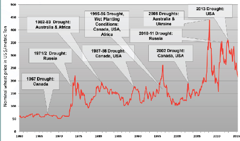
SOURCE: Data from the World Bank; Weight, E. (2018). The National Integrated Drought Information System (NIDIS) of the National Oceanic and Atmospheric Administration. Presentation to the National Academies of Science, Engineering, and Medicine Workshop on Advancing Sustainability of U.S.-Mexico Transboundary Drylands. Available: http://sites.nationalacademies.org/DBASSE/BECS/CurrentProjects/DBASSE_181644 [November 2018].
the expertise of a wide range of federal, tribal, state, local, and academic partners in order to make climate and drought science readily available, easily understandable, and usable for decision makers. DEWS uses a network approach that is designed to evolve and respond rapidly to drought challenges. Weight said the ultimate goal of DEWS is to boost resiliency in affected areas by providing a decision framework for drought management. The framework coordinates research, planning, and education at multiple spatial scales to address underlying risks and vulnerabilities.
Weight outlined several interdisciplinary research applications currently supported by NIDIS. The Evaporative Demand Drought Index5 is an experimental drought monitoring and early warning guidance tool that looks for anomalies in “the thirst of the atmosphere” over 1-week and 12-month timescales. It is currently being used with and validated against the U.S. Drought Monitor (see below). NIDIS is also conducting an assess-
___________________
5 See https://www.esrl.noaa.gov/psd/eddi [July 2018].
ment of the 2017 northern plains drought6 that affected North Dakota, South Dakota, Montana, and the Canadian prairies. It was considered a flash drought, as conditions grew bad very quickly and it led to extreme wildfires and also compromised water resources. More broadly, NOAA has partnered with the Canadian government, and U.S. federal, state, local, and tribal leaders to gain a better understanding of physical drivers of flash drought and their contribution to wildfires. A third tool, the Climate Engine,7 is a Web-based application, powered by Google Earth, that provides on-demand cloud computing and visualization of climate and remote sensing data. It uses a variety of datasets to allow users to visualize various drought indicators.
NOAA also supports the North American Drought Monitor,8 which combines the national drought monitors of Mexico, the United States, and Canada into one product that shows the current status and future outlook of drought across the continent. The North American Seasonal Fire Potential Outlook, the Rio Grande and Rio Bravo Outlooks, and the National Integrated Heat Health Information System are three other drought information products that are integrated into regional drought early warning systems to provide better information for early warning and decision making.
THE NORTH AMERICAN DEVELOPMENT BANK
Laureano Alvarez (North American Development Bank [NADB]) began by explaining that NADB was established in 1994 to develop and finance environmental infrastructure along the U.S.-Mexico border. It is jointly owned by the U.S. and Mexican governments and works in close conjunction with the U.S. Environmental Protection Agency (EPA) and CONAGUA, the Mexican National Water Commission. In the United States, it covers areas in Arizona, California, New Mexico, and Texas; in Mexico, it covers areas in Baja California, Chihuahua, Coahuila, Nuevo León, Sonora, and Tamaulipas. NADB provides certification, financing, and technical assistance to eligible projects, and it includes a loan program that services clients from both the public and private sectors. Alvarez said that as a requirement, all projects funded by NADB must solve an environmental or human health problem and fall within one of the following sectors: water and sewage; residential, industrial, and hazardous waste; air quality; clean/renewable energy; and energy efficiency. Every NADB-funded project
___________________
6 See https://www.drought.gov/drought/documents/2017-northern-plains-drought-assessment [July 2018].
7 See http://climateengine.org [July 2018].
8 See https://www.ncdc.noaa.gov/temp-and-precip/drought/nadm [July 2018].
must first be certified, meaning it has been found to be technically viable, financially self-sufficient, address environmental needs, and contribute to a sustainable environment.
In November 2017, NADB merged with the Border Environment Cooperation Commission and added to its own mission by adopting that commission’s sustainable development criteria, which define full sustainability as a combination of economic, environmental, and social vitality. He reported that as of December 2017, NADB had supported 244 projects, more than one-half of which pertained to water and wastewater. Alvarez explained that NADB also works with the EPA on the Border 2020 Project. As a result of the NADB projects, he reported, wastewater treatment coverage in the border region increased from 21 to 87 percent between 1995 and 2002.
Alvarez described an NADB study on the community of Camargo, in Tamaulipas, Mexico. Camargo’s wastewater treatment plant was inoperable, and residual wastewater was running directly into the Rio Bravo. The study considered, radially, the area of impact from the main focal point, which included some parts of the southwestern United States. He said that because the discharge was going directly into the river, it was not difficult to justify the use of NADB’s funds. However, because the issue is binational, both countries’ requirements for water quality had to be taken into account, and they had to arrive at a mutually agreeable solution for which both countries would take ownership.
In another instance in Sonoyta, Sonora, Mexico, the decision of where to build a wastewater treatment plant led to questions about water redirection, pumping, the energy required, and how it would be funded. As a result of the NADB study, the EPA offered to fund a pilot project to use solar panels on the new water treatment plant. Subsequently, Mexico funded 100 percent of the total cost, and now the Los Alisos water treatment plant is the first plant in Latin America to fully run on solar energy. Alvarez provided several other examples of successful cross-border collaboration that showed how the United States and Mexico successfully shared the benefit and the burden of these innovations.
In terms of regulation, Alvarez noted that NADB complies with international environmental agreements. It occasionally conducts audits of its projects; it has conducted 24 energy audits and 10 water audits and has redefined projects as a result of these evaluations to strengthen infrastructure implementation. The bank has also put together a results, measures, and impact assessment tool used to review project performance. Alvarez said the ultimate goal is to ensure that the sustainable efforts being implemented, such as water savings plans, are properly executed and maintained as the landscape evolves and cities continue to grow.


