
2
California’s Changing Climate and Precipitation Patterns and Their Implications for Water Management
The first topical session of the workshop focused on the results of downscaled climate change models for California used throughout in California’s Fourth Climate Change Assessment (State of California, 2018), with an emphasis on changes to precipitation and snowpack and their implications for water management across the state. As variability and extremes in temperature and precipitation are projected to increase over the coming century, agricultural and municipal water managers could face serious challenges in maintaining reliable service. Michael Hanemann (Arizona State University) provided his reflections on participating in past California climate assessments and working in water law in California, noting that the complicated governance structure of water systems is a further barrier to coordinated and widespread climate adaptation. Daniel Cayan (Scripps Institution of Oceanography) provided an overview of the downscaled climate scenarios used in the Fourth Assessment, describing how changes in both the timing and severity of precipitation events may impact different regions. Andrew Schwarz (California Delta Stewardship Council) presented a bottom-up approach to modeling the sensitivity of state water infrastructure to potential changes in temperature and precipitation, and he called attention to the importance of engaging water managers continually throughout the research process for meaningful co-production of scientific knowledge. Grant Davis (Sonoma County Water) described his experience managing Oroville Reservoir and Lake Mendocino through major precipitation events called atmospheric rivers that are projected to become more common, posing both a flood risk as well as a large potential source of water if system managers can adapt.
MODERATOR: W. MICHAEL HANEMANN, ARIZONA STATE UNIVERSITY
Hanemann began by reflecting on the history of state-led climate assessments in California, calling attention to salient differences to the National Climate Assessments1 coordinated through the U.S. Global Change Research Program,2 as well as several unique practices and strategies that have helped contribute to California’s leadership in climate research and policy. Although subnational climate assessment activities in California began even before 2003 through an initial partnership with the Electric Power Research Institute, a critical turning point according to Hanemann was when then Governor Arnold Schwarzenegger explicitly connected the assessment’s estimates of the economic costs of climate change to the state’s ambitious climate mitigation policies. This direct linkage of
___________________
1GlobalChange.gov, “National Climate Assessment,” https://nca2014.globalchange.gov/.
2 See the GlobalChange.gove website at http://www.globalchange.gov.
climate impact assessment with mitigation policies has not happened nationally, explained Hanemann. He went on to list several distinctive features of California’s assessment process, including the following:
- The collection of research by multiple independent teams using different methodologies and reaching independent conclusions, as opposed to publishing one consensus report;
- The essential role and frequency of iteration and constantly improving on previous assessments as more information becomes available, which was built into the program from the outset;
- The requirement that the reports that make up the assessments are of high scientific quality and can pass the scrutiny of peer review in top-tier scientific journals;
- The financial commitment—on the order of $3 million dollars annually—and dedication of California state government staff; and
- The effort to monetize impacts from climate change as part of the assessment to provide strong inputs to the policy making process.
In reflecting on the decade-plus of climate assessment activity in the state, Hanemann described the change in attitude of local policy and decision makers. Initially, they dismissed the findings of the assessments as a low priority relative to immediate needs, but a decade later the same planners and policy makers were arguing vehemently with authors about the exact extent of projected sea level rise in the assessment compared to those in local guidance documents. “To me that was a sign that [the assessment] mattered to the public and local decision makers. It was a sign of success,” he concluded.
Hanemann then turned to introducing the technical content of the session—projected changes in local precipitation patterns across California and their implications for water use and management decisions. He described downscaling of climate impact models as being scientifically challenging, highly uncertain, and thus controversial, but at the same time as being essential for engaging local policy and decision makers. If you want city mayors, water managers, fire chiefs, and others to use the assessment’s findings, they must see themselves in the projections, he explained. He demonstrated this point by using the comparison of projected changes in precipitation at the spatial scale of global climate models (GCMs) to those from a downscaled California-specific assessment (e.g., see Figure 2.1 in the next section). Climate projections at low resolution are of limited value to local decision makers in part because the high level of aggregation obscures local extremes—for example, that a 2°F warming scenario from a GCM can actually result in 5°F of summertime warming in Los Angeles and Sacramento (Hayhoe et al., 2004). Understanding such variability and local extreme events is critical, as the majority of economic losses (e.g., through decreased productivity or land value) are associated with these extreme heat days (Schlenker et al., 2006; Deryugina and Hsiang, 2014) explained Hanemann, who further suggested that this finding would be generalizable for other variables such as energy consumption or human health impacts. GCMs that focus on average changes and are unable to capture these local extreme events do not capture most of the economic impacts. He concluded with several observations about water infrastructure and governance in California, including the lack of data on current water system operations, the highly fragmented institutions that oversee its operation, and the risk aversion characteristic of water managers (Haneman et al., 2016). Developing a better understanding of current system performance and improving coordination and mechanisms for collective action are essential prerequisites for managing climate change impacts on water systems, said Hanemann.
DANIEL CAYAN, SCRIPPS INSTITUTION OF OCEANOGRAPHY
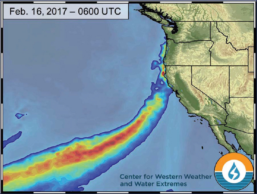
California has tremendous diversity of local geographies and weather, began Cayan, and historically has some of the nation’s greatest temporal variability in precipitation. This underscores the importance of downscaling climate models to reflect regional differences. Using the example of San Diego County, he showed that over the past 100 years, annual precipitation ranged from as little as approximately 6 inches in 1960, 2002, and 2007, to 30 inches or more in 1915 and 1940 and at least six other times since 1975. He noted that the wettest years were driven significantly by just one or two large storms. Physically most of these large rain events, referred to as atmospheric rivers, are rather narrow atmospheric conveyances that often include contain substantial tropical and subtropical
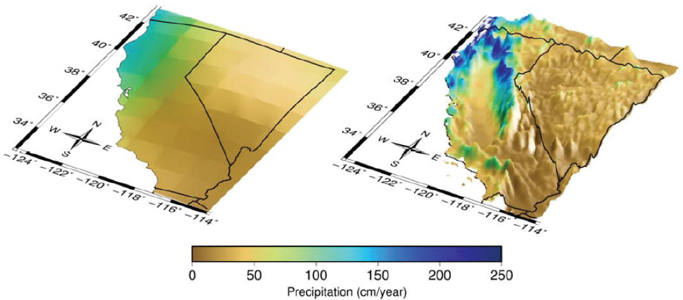
moisture (e.g., see Figure 2.2 in a later section). Because of their tight spatial structure and rapid temporal evolution, atmospheric rivers are one example of the challenges faced in downscaling climate models. The Fourth Assessment used two approaches to downscale outputs from GCMs from the Intergovernmental Panel on Climate Change3 Fifth Assessment (Report: 1) statistical downscaling through localized constructed analogs (LOCAs) can handle large amounts of data and different climate scenarios (Pierce et al., 2018); and (2) dynamic downscaling (see, e.g., Walton et al., 2017). The LOCA method provided simulated historical and future projected climate data from several GCMs at daily resolution on a regular grid of approximately 6 km on a side. This spatial resolution, which is much higher than that from a typical GCM, is crucial for representing the complex topography and many physical processes that occur over California’s coastal, valley, mountain, and desert provinces (Figure 2.1).
Understanding the implications of climate change on California water resources and management is complicated, said Cayan. A major hub of natural and managed water conveyance in the state is the San Francisco Bay and Delta, which not only is affected by changes in snowmelt from upstream mountain headwaters but also will be stressed by sea level rise (SLR). The Fourth Assessment contained probabilistic projections with substantial likelihood of reaching one meter of sea level rise by 2100. The model projections also indicated a small potential (95th percentile and greater) to exceed 6 feet by 2100 for extreme cases under higher greenhouse gas emissions scenarios and rapid ice loss from the poles (Pierce et al., 2018). Many of the model simulations indicate that annual precipitation will not change drastically across the state, said Cayan, but they do exhibit a general trend of wetter in the north and drier in the south and central valley by a few percent. More consistently than changes in amount of precipitation, models suggested that the timing of precipitation will shift, with somewhat more occurring in winter months and less in the spring and fall in most locations in the state. Since temperatures will become warmer and accumulated snowpack will diminish, this shift would exacerbate the serious risk of increased wildfire. Cayan said drought is a feature of California’s highly variable climate, and that it would likely grow as the number of projected dry days increases, in turn leading to dry years and strings of dry years. Simulated snowpack in the mountainous areas of the state show losses of half or more, with corresponding decreases in spring and summer runoff, as elaborated in the Sierra Regional Report (Dettinger et al., 2018). The downscaled projections from the
___________________
3 See the Intergovernmental Panel on Climate Change website at http://www.ipcc.ch/.
Fourth Assessment contained a strong tendency for the region’s wettest days to produce heavier precipitation in future decades, adding to higher runoff from elevated mountain snow levels, which would heighten flood magnitudes. On the other hand, the combined effects of warming and possible declines in spring precipitation would lead to drier spring and summer soil moisture across most of the California landscape.
ANDREW SCHWARZ, CALIFORNIA DELTA STEWARDSHIP COUNCIL
California’s geography and infrastructure make it a test case for understanding how climate change will impact water system operations, began Schwarz. Snowpack occurs at elevations that are sensitive to heat, many of these watersheds in turn feed into a tidal delta subject to sea level rise, and the water infrastructure has relatively little reservoir storage compared to large river systems such as the Colorado. The Central Valley Watershed, managed by the Department of Water Resources (DWR), where Schwarz was employed while conducting this research, is fed by runoff from numerous smaller watersheds primarily from the Sierra, and about 50 percent of the state’s runoff flows into the Sacramento-San Joaquin Delta, where two large pumping plants divert water to southern California and the central valley.
Schwarz described a different approach to handling uncertainty in climate change impact assessment and how it can inform water resources management. As opposed to doing a top-down analysis of climate scenarios downscaled to local conditions and using this information as an input to water system models, Schwarz presented a bottom-up analysis of the central valley water system that explored how sensitive system performance metrics are to changes in temperature and precipitation. The analysis then overlaid a distribution of downscaled climate model runs over the system performance map to assign a likelihood to the observed changes, and in this way used the most uncertain element of the analysis—the downscaled climate impact model—at the end of the analysis. He noted that results are consistent with system simulation results using the Fourth Assessment downscaled projections but provide a much broader assessment of uncertainty and the relative likelihood of outcomes across the range of uncertainty. Applying this method to numerous performance metrics such as reservoir carryover storage or water deliveries showed that there is greater probability of decreased system performance by midcentury (Schwarz et al., 2018). Schwarz explained that this approach allows water managers to test hypothetical adaptation strategies in their model and explore how the performance and uncertainty change, and that presenting this information as probability distributions aligns well with risk-informed decision-making practices that have historically been used to guide investment in the industry.
Schwarz closed with several comments on co-production of science, emphasizing that this partnership between academic researchers and government water managers was successful because each party stood to benefit from the other’s participation. His academic collaborators in the University of Massachusetts-Amherst Hydrosystems Research Group gained access to water system models and an understanding of management decision making, and staff at DWR gained access to advanced simulation methods and the bottom-up modeling framework. Other characteristics of the collaboration that contributed to successful co-production of science included that each team had dedicated staff working on the project, which can be a challenge in government organizations to secure funded time for staff to work in a research and development (R&D) capacity. Through daily interactions they were able to guide the project to align with the department’s decision-making needs, Schwarz said.
GRANT DAVIS, SONOMA WATER
Davis began by reiterating the importance of partnerships between government and academia, pointing to the benefits his organization has gained from a formal memorandum of understanding between Sonoma Water and Scripps Institution of Oceanography to better understand and prepare for atmospheric rivers (Figure 2.2). These extreme weather events can carry upward of 10 to 20 times the volume of water at the mouth of the Mississippi River, he said, and along with drought are an increasing challenge for water managers in the West. Davis illustrated these challenges by sharing his experience with two reservoirs—Lake Oroville after the 2017 catastrophic spillway failure and an ongoing project at Lake Mendocino. In February 2017 damage was detected on the main spillway at Lake Oroville resulting in its closure, while at the same time an atmospheric river was projected
to impact the area. Inflow from this storm was significantly more than expected, which in turn required use of the emergency spillway for the first time. Shortly thereafter, a partial failure of the emergency spillway prompted the evacuation of over 180,000 residents below the reservoir. Efforts by the Department of Water Resources and their contractors to repair the facility were affected by the cascading impacts of extreme weather far away, first when hurricane Harvey damaged a primary supply of liquid nitrogen used to cure cement and again when hurricane Irma damaged the offices of one of their subcontractors. Davis concluded that these lessons provide an excellent case study as to how the increasing numbers of extreme weather events will affect water managers and why additional resources are needed to better understand the phenomenon of atmospheric rivers.
Davis shared a second example of ongoing work at Lake Mendocino, which is a coastal watershed co-managed by the U.S. Army Corps of Engineers (USACE) and Sonoma Water. The lake is one of two reservoirs on the Russian River and is an ideal test case. First, it is isolated from the Bay-delta system, so flood risk in the Russian River will not damage the larger state water system. Second, the integrated governance structure allows for streamlined decision making, and third, it provides a clear example of a recent challenge. He compared the water year of 2012, which was near ideal with late spring rains that could be stored without exceeding the USACE flood requirements, to the 2013 water year when a winter atmospheric river deposited large amounts of water that had to be released just before the ensuing spring and summer drought. This motivated Sonoma Water to develop and implement forecast-informed reservoir operations at Lake Mendocino, and they have requested a major deviation from traditional flood control levels for the year 2019 with the goal of capturing and storing additional water without increasing flood risk. Science is the foundation for informed adaptation investments, said Davis, and the partnership between government and academia continues to be an essential feature of this project. Davis concluded with several research investments that would benefit water managers, including physical measurements and modeling to better understand atmospheric
rivers; improving the accuracy of 14-day weather forecasts, which have one-tenth the accuracy of a 7-day forecast; and seasonal to subseasonal forecasting, which will improve long-term water system performance.
PANEL DISCUSSION
Laurna Kaatz of Denver Water clarified that Schwarz’s work on bottom-up system sensitivity analysis was based on the historical record (although not just the observed record but going back nearly 1,000 years using tree ring data), then asked how water utility managers and other decision makers can prepare for individual extreme events that may be lost in averaging over historical values. She explained that when we monitor warming of 1 or 2°F, there have likely been individual days that are 10 or more degrees above historical record and that these extremes have significant implications for decision makers. Schwarz replied that, although that was not the focus of this project, the DWR in collaboration with the USACE are undertaking a project that combines the decision scaling method with a local weather generation model using boundary conditions informed by global climate models to explore flood risk associated with extreme events like atmospheric rivers.
Susanne Moser of Susanne Moser Research and Consulting noted that each presentation identified the importance of engaging decision makers to inform scientific research so that it is more immediately useful, and asked the panel to elaborate on their perceived research needs in the area of governance, human and institutional decision making, and the social sciences more broadly. Schwarz responded that the research he presented was an academic collaboration sponsored by DWR to answer a specific management decision, and there may be an opportunity going forward to more closely align the products of California’s climate assessments to the immediate needs of decision makers by requiring agency partnerships for each project. Davis commented that large agencies or organizations such as DWR have resources and staff that can accommodate academic partnerships and more R&D-type work, but that smaller organizations will require effective governance and additional resources from the state and federal government to meaningfully incorporate research outputs into actual management decisions. Hanemann recounted the initial disinterest in climate change adaptation shown by water utilities alongside other examples of organizations being rigid and risk adverse, saying that some of the challenge is simply that institutional and individual behaviors change slowly. Cayan said the partnerships reflected in the Fourth Assessment reflect strong relationships between individuals in different organizations and these took time to develop. He also noted that private sector partnerships in the Fourth Assessment are limited and are clearly an area for future growth.
Steve Frisch, Sierra Business Council, commented on the cascading impacts of an atmospheric river to flooding and delayed spillway repairs in Lake Oroville, asking whether water managers consider the impacts of upper watershed forest management on runoff and flood risk. Davis responded that the health of the Sierra is essential for clean water supply, and that he considers wildfires one of the biggest threats to Sonoma County Water. Schwarz explained that upper watershed management is one of the adaptation strategies being considered by DWR, and some research suggests that current tree stocking levels in some of the Sierra are much higher than historical levels. He encouraged further study and quantification of potential additional water and associated co-benefits from upper forest management.
Cathy Whitlock, Montana State University, asked Cayan to comment on the use of statistical downscaled models as opposed to more sophisticated methodologies that may be able to better reflect phenomena like atmospheric rivers. Cayan responded that to the extent that atmospheric rivers are represented in the data used to construct the statistical model, they are carried forward in future projections. Both statistical and dynamic models will be needed going forward, he explained—the former to conduct a large number of simulations, and the latter to gain a more fine-grained understanding of processes. Nonetheless, they both have limitations and challenges, and Cayan echoed earlier comments about the importance of measurements to underpin modeling results.
REFERENCES
Deryugina, T., and S.M. Hsiang. 2014. “Does the Environment Still Matter? Daily Temperature and Income in the United States.” No. w20750. National Bureau of Economic Research. https://www.nber.org/papers/w20750.
Dettinger, M., H. Alpert, J. Battles, J. Kusel, H. Safford, D. Fougeres, C. Knight, et al. 2018. “Sierra Nevada Summary Report.” California’s Fourth Climate Change Assessment. SUM-CCCA4-2018-004. http://www.climateassessment.ca.gov/regions/docs/20180827-SierraNevada.pdf.
Hanemann, M., S. Sayre, and L. Dale. 2016. The downside risk of climate change in California’s Central Valley agricultural sector. Climatic Change 137(1–2):15–27.
Hayhoe, K., D. Cayan, C. Field, P. Frumhoff, E.P. Maurer, N.L. Miller, S.C. Moser, et al. 2004. Emissions pathways, climate change, and impacts on California. Proceedings of the National Academy of Sciences 101(34):12422–12427.
Pierce, D.W., J.F. Kalansky, and D.R. Cayan. 2018. “Climate, Drought, and Sea Level Rise Scenarios for California’s Fourth Climate Change Assessment.” California’s Fourth Climate Change Assessment. CNRA-CEC-2018-006. http://www.climateassessment.ca.gov/techreports/docs/20180827-Projections_CCCA4-CEC-2018-006.pdf.
Schlenker, W., M. Hanemann, and A.C. Fisher. 2006. The impact of global warming on U.S. agriculture: An econometric analysis of optimal growing conditions. Review of Economics and Statistics 88(1):113–125.
Schwarz, A., P. Ray, S. Wi, C. Brown, M. He, and M. Correa. 2018. “Climate Change Risks Faced by the California Central Valley Water Resource System.” California’s Fourth Climate Change Assessment. CCCA4-EXT-2018-001. http://www.climateassessment.ca.gov/techreports/docs/20180827-Water_CCCA4-EXT-2018-001.pdf.
State of California. 2018. California’s Fourth Climate Change Assessment. http://www.climateassessment.ca.gov/.
Walton, D.B., A. Hall, N. Berg, M. Schwartz, and F. Sun. 2017. Incorporating snow albedo feedback into downscaled temperature and snow cover projections for California’s Sierra Nevada. Journal of Climate 30(4):1417–1438.


