
7
Finding Commonalities and Differences with Other Subnational Assessments (Part 2)
The second session explored commonalities and differences in subnational assessment processes across the United States and featured assessments done by counties, cities, and metropolitan areas as well as those focused on specific economic sectors and utilities. Similar to previous presentations, the session participants emphasized the process of climate assessment activities as well as sharing locally specific impacts and vulnerabilities. Cathy Whitlock (Montana State University) moderated the session, noting that narrower geographic boundaries and sector-specific assessments can facilitate connection and communication with key stakeholders. Jennifer Jurado (Broward County government) described the severe threats faced by coastal southern Florida to sea level rise (SLR), flooding, and hurricanes, and elaborated on the challenges presented to local governments by complex and overlapping jurisdictions of state, county, and city authorities. Laurna Kaatz (Denver Water) shared a southwestern water utility perspective on climate assessment and adaptation, emphasizing the value of smaller iterative assessment activities as opposed to large and infrequent efforts. Ann Phillips (Center for Climate and Security) described the challenges faced by Hampton Roads, Virginia, which has a large presence of military facilities and complex government structures, in assessing and adapting to climate change impacts, notably coastal flooding. Melissa Allen (Oak Ridge National Laboratory) presented an assessment done for the Tennessee Valley Authority looking at impacts to electricity generation and demand and raising the potential for population influx to the region as it is less impacted by climate change relative to other areas.
MODERATOR: CATHY WHITLOCK, MONTANA STATE UNIVERSITY
Continuing the discussion of subnational assessments from the previous session, Whitlock noted that this session will consider more targeted assessments done for particular sectors or regions. The panel members’ experience spans the Southeast Florida Regional Climate Change Compact; the Denver Water Department’s climate adaptation program; sea level rise issues in the Hampton Roads, Virginia, area; and population dynamics and climate adaptation in the Tennessee Valley.
JENNIFER JURADO, BROWARD COUNTY, FLORIDA
Jurado focused on how Broward County utilizes information developed during the assessment process and spoke specifically about regional SLR projections developed within the Southeast Florida Regional Climate
Change Compact1 as adaptation strategies focused on flooding. Broward County is a well-developed urban area with approximately 2 million residents wedged between the Everglades and the Atlantic Ocean. Thus, their adaptation strategies are confined within a relatively narrow urban footprint. She explained that not only does Broward County have 24 miles of beach with extreme exposure to SLR and storm surge, but it also has hundreds of miles of seawalls and canals. Most of the surface water drainage is powered by gravity and discharges to tide (i.e., coastal waters), so SLR makes it more difficult to move water. In addition, the area has porous geology that is losing freshwater storage capacity due to SLR. Active flood control and water management have always been major issues for Broward County and become more challenging with changing climate.
Climate change has been a discussion in the region since the 1990s but began in earnest in the mid-2000s. The region has undertaken numerous assessments on both climate mitigation and adaptation, including as part of the Compact, which is a collaboration between Broward, Miami-Dade, Monroe, and Palm Beach counties. Jurado acknowledged that while the region is addressing both mitigation and adaptation priorities, there are more constraints on emissions mitigation efforts as a function of state policy. The county is working to maximize adaptation efforts through its internal processes and under its authority as a charter county, embedding climate change into comprehensive planning, land use, emergency management, transportation, and capital budget processes. She used this context to introduce ongoing planning efforts in Broward County to prepare for potentially significant impacts on regional hydrology. She noted that the Southeast Florida Regional Climate Change Compact developed a unified SLR projection for the counties of southeast Florida. While there are several scenarios represented, in general the counties consider potential for a 2-foot rise by 2060. Jurado described how the county adopted a future conditions map series that provides the framework for integrating resilience standards in licensing and project design requirements. The county has established targeted areas for resiliency standards, including drainage infrastructure, elevations for coastal flood barriers, and projected flood elevations, all relying on the SLR projections, estimates of changes in rainfall, and sophisticated hydrologic models. She demonstrated how this map series and affiliated tools are being used to update the estimates for the average wet season groundwater table map, which are significant, as these determine what type of infrastructure is required for drainage and surface water management. Using the projections of SLR and rainfall along with complex groundwater models, the county modeled the increase in these elevations. The results show that there are significant increases in groundwater elevations as far as 6 miles from the coast, which affects drainage infrastructure and interconnected water management systems. Since amending ordinances involves a significant stakeholder community including elected officials and others, it is important to involve these stakeholders very early in the modeling exercises.
Some of the main groups concerned about this analysis were the consulting engineers and development communities that needed to understand the implications for construction site development. Jurado worked with the county’s engineering and licensing division to select some representative sites in the most impacted eastern part of the county to estimate the impacts on the drainage requirements. The results indicate that development costs might increase by less than 2 percent, which reassured developers and commissioners. Jurado also went through a study that the county is doing with the U.S. Army Corps of Engineers to develop a standard for resilient seawall top elevations. Funding requirements for a coordinated investment in seawall infrastructure improvements could exceed $5 billion dollars. Similarly, Jurado introduced work that the county is doing to update Broward County’s community flood guidance. In summary, Jurado noted the success that the county has had in incorporating science in the applications of advance hydrologic models to inform policy and planning decisions. It has also been enormously valuable to look at scenarios, but in the end, the community needs a number, something definitive to plan around, she said. A priority next step, she concluded, is to apply these model outputs in the development of an infrastructure investment plan for both new and existing infrastructure.
___________________
1 See the Southeast Florida Regional Climate Change Compact website at http://www.southeastfloridaclimatecompact.org/.
LAURNA KAATZ, DENVER WATER
Kaatz began by discussing Denver Water’s approach to climate adaptation through assessment, planning, and the value of collaboration. Denver is in an arid environment where half the climate projections indicate that weather is going to get wetter and half predict it will get dryer, she said. Colorado itself is divided by what Kaatz characterizes as topography that is impressive for a skier or backpacker but challenging for a water supply manager. Eighty percent of Colorado’s water is on the west side of the continental divide, whereas 80 percent of the state’s population, including the city of Denver and most of the economic centers, are on the eastern side. Denver Water serves 25 percent of the population of Colorado, with half of its water supply coming from the western side of the continental divide (i.e., the Colorado River basin) and half from the eastern side (i.e., the South Platte River basin). She explained that Denver gets its water from high elevation watersheds that are already showing impacts from climate change.
In 2002, unprecedented simultaneous natural disasters struck critical components in Denver’s water supply system, prompting them to begin actively studying and preparing for climate change impacts. Prior to that, their planning stayed within a narrow cylinder of certainty, she said, and followed a more deterministic approach. They planned for the worst drought in the hydrological record, which occurred in the 1950s, and concluded that if demands could be met, then supplies were adequate. However, in 2002 they experienced the single worst drought year on record as well as a month-long forest fire, which resulted in impacts to water availability and heavy debris loading that took their largest water treatment plant out of service. This caused the water utility to consider a broader set of potential impacts that it could face by looking further back into history by using tree ring data, which suggested droughts well beyond the immediate hydrological record. Using this expanded record to look into the future, they undertook the Joint Front Range Climate Change Vulnerability Study (Water Research Foundation, 2012) in collaboration with the Western Water Assessment,2 National Center for Atmospheric Research, and Riverside Technologies. There were many benefits of such a regional approach, explained Kaatz, including the pooling of expertise and resources, and providing political coverage for other utilities in the region to engage in a climate assessment.
Kaatz noted that, initially, those involved in the vulnerability study thought science was going to definitively solve the problem of what climate change will mean for the region’s future hydrologic conditions, but instead found a range of plausible yet distinctly different outcomes. Model projections for the central mountains of Colorado generally agree that climate is going to get warmer, but disagree on the extent and timing of warming. Similarly, there is disagreement on the potential impacts of climate change on precipitation. The study helped Denver Water with its climate adaptation and planning philosophy, but the divergence of projected impacts led the utility to examine more simple assessments such as looking at the supply implications due to warming alone. Thus, planning at Denver Water moved from looking at historical probabilities, to shifting probabilities, to life without probabilities, embracing deep uncertainty and preparing for whatever might happen, she said. That brought them to Scenario Planning, a tool to support planning for a range of plausible future conditions and seeking robust strategies in future investments. This means developing an adaptive, iterative planning and investment strategy with a diversified portfolio of scalable options, she concluded.
ANN PHILLIPS, CENTER FOR CLIMATE AND SECURITY
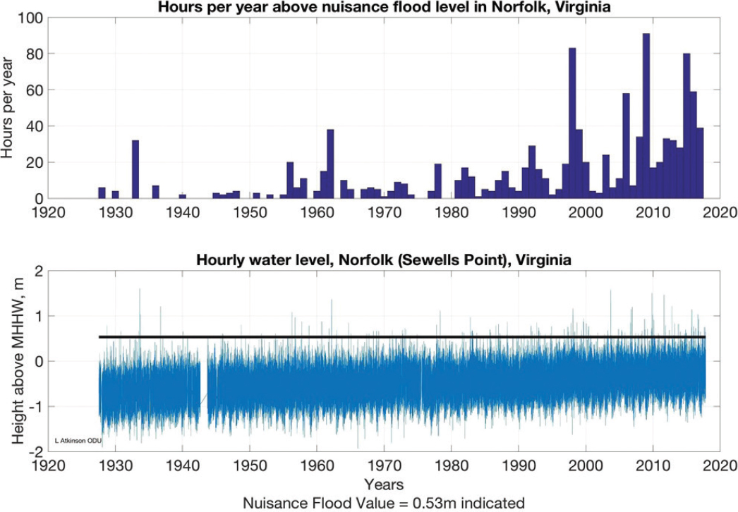
Phillips shared some of the challenges associated with increasing coastal flooding caused by SLR and land subsidence in Hampton Roads, Virginia, and described how Hampton Roads is a crucible for the climate adaptation challenges that lie ahead for coastal regions of the United States and globally. Hampton Roads is a low-elevation coastal community where SLR poses an existential threat to the region, she said, showing the increasing frequency and duration of nuisance flooding in Norfolk (Figure 7.1). Phillips pointed out that at some point, the average high tides will be above the nuisance flooding level. The greatest challenge they face is in regional coordination and collaboration, she said. The whole region uses the same transportation and housing infrastructure, is served
___________________
2 See the Cooperative Institute for Research in Environmental Sciences, University of Colorado, Boulder, Western Water Assessment website at https://wwa.colorado.edu/.
by the same utilities, and is tied together through a water-based economy dependent on the substantial federal and commercial maritime presence. It is an incredible challenge to initiate and coordinate adaptation by an array of federal entities, 17 separate cities and municipalities, neighborhoods, and transportation corridors in the context of increased flooding. Adaptation is beginning independently but is moving at a slow pace, said Phillips, and there is a critical need for collaboration across the region. However, the state laws of Virginia require that any sort of formal regional cooperation must be authorized by the state government.
Many regional studies, projects, and assessments have been undertaken to look at this issue at the state, regional, and local level; however, Phillips expressed concern that most have been put on the shelf and their findings ignored. Phillips cited the Hampton Roads Resilience Forum3 as a positive outcome to bring universities, industry, and local and federal government representatives together to share science and other information across the many disciplines. These events have been well attended and increased the recognition of the need for common standards across the different jurisdictions in the region, she explained. Other efforts include Norfolk receiving a grant from the Rockefeller Foundation 100 Resilient Cities Program,4 which supported the city having its own resilience officer and is supporting development of a Vision 2100 plan.5 This plan provides definitions for critical
___________________
3 Commonwealth Center for Recurrent Flooding Resiliency, “Hampton Roads Resilience Forum—How the Region Works with Water,” https://www.floodingresiliency.org/event-hampton-roads-resilience-forum-how-the-region-works-with-water/.
4 See the 100 Resilient Cities website at http://www.100resilientcities.org/.
5 City of Norfolk, Norfolk Vision 2100, adopted November 22, 2016, https://www.norfolk.gov/DocumentCenter/View/27768.
infrastructure based on citizen input, and it divides the city into regions for future development based on elevation and density. Phillips also discussed the Hampton Roads Integrated Sea Level Rise Pilot Planning Project (Steinhilber et al., 2016), an effort that she helped lead as the Infrastructure Working Group chair. The outcomes of that project included recommendations to set regional standards; base those standards on the best possible science and engineering data; identify and prioritize critical infrastructure across the region and develop strategies to protect or adapt that infrastructure; and determine how to finance adaptation activities. The Port of Virginia has conducted similar analyses, but those should also be done for the federal facilities in the region, she said. Recent actions include the development of a SLR subcommittee on the Hampton Roads Planning District Commission and the development of coastal resiliency program goals by the commission. Individual cities within the region are also beginning to take action, she said, but are giving little consideration as to how the various projects may impact neighboring jurisdictions.
In summary, Phillips noted that federal, state, and local stakeholders and governance structures add complexity for adaptation actions in Hampton Roads. Further, the national security implications for SLR in this region require urgent action, she said. In considering how to move ahead, there must be increased regional science and engineering-based opportunities to share information and expand collaboration. Public education and inclusion in the collaborative process will be essential, said Phillips. To move forward, she described the need for establishing a regional “Special District/Political Subdivision” under Virginia state law to enable formal regional collaborations. Further, assessments of SLR need to engage the regional business community, and coordinated public (including local, state, and regional governments) and private sector funding strategies must be developed to bankroll costly adaptation measures.
MELISSA ALLEN, OAK RIDGE NATIONAL LABORATORY
Allen discussed the costs and benefits of climate resilience investments using a case study done with the Tennessee Valley Authority (TVA) in collaboration with Oak Ridge National Laboratory (ORNL) and the Department of Energy. The study considered the potential impacts of two extreme events, a heat wave and a drought, on TVA electric infrastructure and evaluated the utility’s ability to supply energy during such conditions. Related to climate impacts, Allen also discussed a study for the southeastern United States looking at how people moved in response to the 2005 hurricane season as well as a study for Knoxville on the potential impacts for the city from climate change.
Allen explained that the TVA case study considered a simultaneous drought and heat wave in the 2050s based on data from a historical heat wave (1993) and drought (2007) that they superimposed on the average change in temperature associated with the recent Intergovernmental Panel on Climate Change analysis under the high emissions scenario (Allen et al., 2017). Increased water temperatures and evaporation from lakes were accounted for. The TVA infrastructure considered in the case study was limited to the Cumberland River basin, where fossil-based thermal power dominates, but significant electricity generation comes from hydropower and other sources. Under the heat wave projections and population growth assumed out to 2050, electricity demand increased by 87 percent, while reduced water flow, increased evaporation, and increased demands for cooling water could result in hydropower production of only 35 to 60 percent of its normal rates. In terms of fossil energy power generation, the impacts of higher temperatures on gas turbine efficiencies and reductions in availability and higher temperatures of cooling waters could have a net reduction in available capacity from fossil fuel of up to 40 percent. Taken together, the impacts are a simultaneous increase in demand and a reduction in overall electricity generation capacity in the region. Allen estimated the cost of these impacts by assuming the shortfall in electricity was made up by purchases through the wholesale electricity market, with direct costs of almost $500,000 per day, not including the potential costs of any electricity outages. Some of these issues might be addressed by TVA’s Integrated Resource Plan by, for example, increasing the use of non-water-consuming alternative electricity generation technologies and expanding long-distance electricity interconnections, she explained.
Allen went on to discuss additional climate adaptation issues for the region by looking at the entire southeastern United States, specifically considering relocation routes associated with residents displaced by Hurricane Katrina (Allen et al., 2014). The Tennessee Valley was in the top 20 destinations for relocations associated with this event,
in part because the area will be relatively less affected by climate change than other parts of the country. Thus, the Tennessee Valley may provide the right conditions to attract new businesses and resulting increase in population, which could further stress resources in the region. Allen went on to briefly discuss a collaborative project with ORNL and the city of Knoxville sustainability office, for which a tool was created to answer some representative questions regarding flood mitigation (Nugent et al., 2017). This project considered use of green infrastructure for flood mitigation and how increases in temperature and changes in precipitation patterns can change the hardiness zone of an area, potentially changing what plants have traditionally been used for such projects. In concluding, Allen noted that many of the limitations of climate assessments have already been mentioned and included that many estimates of future losses are based on past examples but that future extreme events may be much more extreme.
PANEL DISCUSSION
Cathy Whitlock asked the panel to comment on techniques to communicate future scenarios effectively to infrastructure planners and decision makers that helped foster cooperation and collaboration. Allen replied that involving stakeholders from the beginning in project scoping and definition was key, and she recommended first understanding stakeholders’ concerns and then developing studies that address those concerns. A crisis can be helpful to remind people of the significance of being prepared, added Kaatz, and being aware of an individual’s or institution’s risk tolerance is also important. The mission of a water agency is to provide a continuous, reliable source of water, and therefore it has a very low risk tolerance. Combining this attitude with the threat of crisis has been an effective way of galvanizing action in her community. Jurado cautioned against a conversation that outlines only impacts and does not include solutions and their benefits. She highlighted developing a framework for regional collaboration within Florida to serve as a resource to the community, sharing expertise and tools with neighbors, and designing a feasible short-term plan. Phillips described the importance of educating local politicians in addition to constituents in coastal Virginia on both the risks faced and the adaptation options being considered. She agreed that extreme events like hurricane Matthew in 2016 could help focus public attention and drive progress. Even though memories of the consequences of extreme events fade quickly, Phillips said they have sparked small pockets of progress such as new zoning restrictions and a storm water study in her community.
Nik Steinberg asked Jurado why she chose to utilize shorter-term 25-year timeframes for planning purposes instead of using a 250-year period as a worst-case scenario. He continued that, since building infrastructure to be robust on such a long timescale would be very expensive, how can we think about financing such large and costly investments? Jurado replied that they did look at using more severe surge scenarios but determined that most of the infrastructure is not designed nor financed around that long of a time scale. Therefore, the county is more interested in addressing more regular flooding occurrences, while recognizing that there will be events that exceed the design of the infrastructure. Planning for extreme weather and flooding events is more difficult, she said, and involves major movements of population, creative opportunities for land acquisition, and rethinking land use and development norms. She continued that real estate value is essential to the economy of Broward County, and because Florida does not have income tax, they rely heavily on property and sales taxes. Therefore, if they see an erosion in property values, the community will not be able to recover the revenue necessary for the appropriate infrastructure required. This is a fundamental part of the conversation around infrastructure planning in Florida and a central piece to the argument that both short-term and long-term planning are necessary, she concluded.
Referencing Jurado’s earlier call for a uniform flood mitigation standard across all jurisdictions, Michael Croft asked if downstream communities should undertake the massive costs unless all upstream communities have implemented identical standards. Jurado acknowledged that local conditions need to be evaluated when establishing standards to tailor resilience standards to individual communities. However, she added, when we look at shared costs nationally, it must be recognized that no one community is insulated from the impacts on another, as the economic consequences are shared. She advocated for minimum standards instead of blanket standards so that a community is not precluded from exceeding standards. Phillips added that Hampton Roads faces this challenge; if cities exceed a state minimum standard, they could be sued and forced to return to the lower standard.
REFERENCES
Allen, M., S.J. Fernandez, J.S. Fu, and K.A. Walker. 2014. Electricity demand evolution driven by storm motivated population movement. Journal of Geography and Natural Disasters 4(126). doi: 10.4172/2167-0587.1000126.
Allen, M., T.J. Wilbanks, B.L. Preston, S.-C. Kao, and J. Bradbury. 2017. “Assessing the Costs and Benefits of Investments in Climate Resilience: Tennessee Valley Authority Case Study.” Oak Ridge National Laboratory. ORNL/TM-2017/13. https://info.ornl.gov/sites/publications/Files/Pub72433.pdf.
Nugent, P.J., O.A. Omitaomu, E.S. Parish, R. Mei, K.M. Ernst, M. Absar, and L. Sylvester. 2017. A web-based geographic information platform to support urban adaptation to climate change. Pp. 3711-381 in Advances in Geocomputation (D.A. Griffith, Y. Chun, and D.J. Dean, eds.). Springer, Cham.
Steinhilber, E.E., M. Boswell, C. Considine, and L. Mast. 2016. “Hampton Roads Sea Level Rise Preparedness and Resilience Intergovernmental Pilot Project. Phase 2 Report: Recommendations, Accomplishments and Lessons Learned.” Hampton Roads Intergovernmental Pilot Project: Reports, 2. https://digitalcommons.odu.edu/hripp_reports/2.
Water Research Foundation. 2012. Joint Front Range Climate Change Vulnerabiltiy Study. https://climatewise.org/images/stories/pdfs/Publications/ClimateWise/Joint_Front_Range_Climate_Vulnerability_Study.pdf.


