


Below is the uncorrected machine-read text of this chapter, intended to provide our own search engines and external engines with highly rich, chapter-representative searchable text of each book. Because it is UNCORRECTED material, please consider the following text as a useful but insufficient proxy for the authoritative book pages.
23 This chapter describes the benefits of using GIS to support land use compatibility around airports. Benefits accrue from efficiency (i.e., time or money savings) and effectiveness (i.e., new capabilities delivered) gained from using GIS to address the land use compatibility con- cerns. While general provisions that guide potential GIS collaboration are presented, it is rec- ommended that careful consideration be taken on a site-specific basis to address concerns of individual airports and surrounding communities as there are varying degrees of compatibility based on the variations presented in Chapter 1. Validating land use compatibility and incompatibility is vital to current planning initiatives, community development, and comprehensive planning. In research conducted for this guide- book, GIS is identified by most as a critical tool for this purpose, saving considerable time over alternative methods. Most local governments use state-licensed land surveying in concert with geospatial location and mapping tools such as Google Earth, computer aided drawing (CAD), and/or GIS as primary methods to disseminate data and maps. GIS allows these practitioners to conduct queries and analyses they would not otherwise be able to do, such as correlation of data based on location and examining relevant patterns. Those that conduct this work use GIS daily and report results that geospatial analysis pro- vides greater confidence with decisions, recommendations, and communication of practical results to others. Research findings conclude GIS is widely used to prepare maps and exhibits to communicate the land use compatibility issues, as well as to develop zoning restrictions to encourage compatible land use. GIS tools are most effectively utilized across multiple local government departments. Depend- ing on individual municipal organization structures or designated roles and responsibilities, these tools may be either centrally located or employed through an IT department, planning depart- ment, engineering department, or economic development department. Many local governments harness the full power of a GIS by employing enterprise-wide GIS systems and using them to make informed decisions and to anticipate needs before they become pressing. Therefore, GIS is acknowledged as a powerful planning tool for informed government decision making. Like many municipalities or large public works organizations, most large commercial service airports also have invested in enterprise GIS or asset management systems to capture informa- tion stored in planning, design, construction, engineering, and other information databases, and leverage customized reports and applications to make better decisionsâlargely related to financial planning and operational efficiency. Many of these systems are custom-made by vendors and fit into the construct of large-scale asset management programs. On the other hand, many airports have limited resources and staff, and investments in geospatial-related infrastructure are often viewed as idealistic. Furthermore, because airport C H A P T E R 3 Benefits of GIS for Land Use Compatibility Planning
24 Using GIS for Collaborative Land Use Compatibility Planning Near Airports staff is immersed in day-to-day federal-level airport planning, engineering, and operational terminology and requirementsâdiffering from the localized city planning nomenclature and regulations of community plannersâairport staff is often unaware of geospatial tools the local community may employ. The most successful enterprise systems have executive champions that not only promote and utilize the information, but also garner support from other managers to enable sustained financial investments for the long term. Without management champions, even the best enter- prise systems run the risk of devolving into obsolescenceâparticularly if data is not kept up to date, is not often used by multiple departments, or technological advances overtake system functionality. There are numerous benefits to all stakeholders from the implementation of AGIS. Local GIS enterprise systems also have been documented to show tremendous benefits by providing better data and maps to enable quick decision making from understanding the broader picture through the lens of accurate data. Many of these benefits are directly related to helping with land use compatibility. These include: ⢠Planning and early design. GIS data provides up-to-date information on airport infrastruc- ture including exact locations, safety protection areas as well as tools to do initial assessments of the feasibility of alternatives (including satisfying land use compatibility and incompat- ibility) for airport projects. Planners and designers avoid expending resources on infeasible alternatives to identify best alternatives early in the design process. ⢠Collaboration with FAA air traffic and FAA airports. GIS dataâparticularly if it has been col- lected, uploaded, and approved in AGISâprovides location-based accuracy for obstructions to navigable airspace and safety areas on and off the airport property. Obstruction Identifica- tion Surfaces (OIS) provide data sufficient to serve flight procedures development in compli- ance with the FAA TERPS Order as well as with Part 77 surfaces requirementsâpopulating information in airspace and inner airspace drawings required in an ALP. AGIS data is viewed as the gold standard as it relates to safety-critical data because it has been validated and verified by the NGS. Thus, AGIS data becomes a valuable resource related to utilization of the data to collaborate across land use compatibility issues. This benefit stream applies primarily to airports with commercial service, but numerous airports without com- mercial service have captured data to AGIS standards for various projects over the last decade. With respect to additional data and datasets beyond safety-critical data, GIS data collected for the airport can inform sections of a master plan update (such as inventory) as well as populate most of an ALP. Local GIS data can be incorporated into AGIS datasets or serve as stand-alone information that can be leveraged for land use compatibility analysis. Moreover, local planning departments often employ GIS software and licenses that an airportâparticularly smaller airportsâmay not. Thus, GIS enables collaboration across the organizational constructs of community planning and airport planning practitioners. ⢠Flexibility of data and cost efficiencies. AGIS data collection as part of AIP-funded airport projects create a valuable GIS dataset for airports. Since most of the cost of adopting GIS relates to creating an initial dataset, airports are more likely to adopt additional applications (e.g., airfield maintenance, leasehold management) provided by FAA and third party vendors. ⢠Improved safety and land use compatibility. The quantity, consistency, timeliness, and avail- ability of airfield data that AGIS provides will increase the situational awareness of safety hazards to pilots, ground workers, maintenance personnel, and construction crews working on an airfield. AGIS data is a resource that can help identify utility breaks, interference with NAVAIDs, and a host of other potential hazards caused by lack of information. The avail- ability of information during planning and design can also lead to safer designs and better land use compatibility planning as more scenarios and alternatives can be considered.
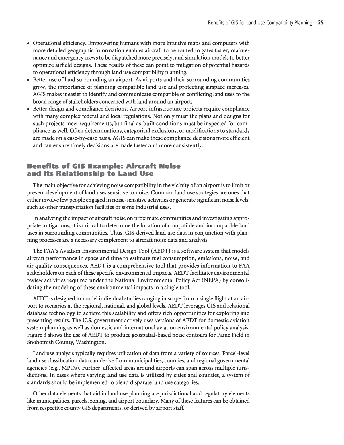
Benefits of GIS for Land Use Compatibility Planning 25 ⢠Operational efficiency. Empowering humans with more intuitive maps and computers with more detailed geographic information enables aircraft to be routed to gates faster, mainte- nance and emergency crews to be dispatched more precisely, and simulation models to better optimize airfield designs. These results of these can point to mitigation of potential hazards to operational efficiency through land use compatibility planning. ⢠Better use of land surrounding an airport. As airports and their surrounding communities grow, the importance of planning compatible land use and protecting airspace increases. AGIS makes it easier to identify and communicate compatible or conflicting land uses to the broad range of stakeholders concerned with land around an airport. ⢠Better design and compliance decisions. Airport infrastructure projects require compliance with many complex federal and local regulations. Not only must the plans and designs for such projects meet requirements, but final as-built conditions must be inspected for com- pliance as well. Often determinations, categorical exclusions, or modifications to standards are made on a case-by-case basis. AGIS can make these compliance decisions more efficient and can ensure timely decisions are made faster and more consistently. Benefits of GIS Example: Aircraft Noise and its Relationship to Land Use The main objective for achieving noise compatibility in the vicinity of an airport is to limit or prevent development of land uses sensitive to noise. Common land use strategies are ones that either involve few people engaged in noise-sensitive activities or generate significant noise levels, such as other transportation facilities or some industrial uses. In analyzing the impact of aircraft noise on proximate communities and investigating appro- priate mitigations, it is critical to determine the location of compatible and incompatible land uses in surrounding communities. Thus, GIS-derived land use data in conjunction with plan- ning processes are a necessary complement to aircraft noise data and analysis. The FAAâs Aviation Environmental Design Tool (AEDT) is a software system that models aircraft performance in space and time to estimate fuel consumption, emissions, noise, and air quality consequences. AEDT is a comprehensive tool that provides information to FAA stakeholders on each of these specific environmental impacts. AEDT facilitates environmental review activities required under the National Environmental Policy Act (NEPA) by consoli- dating the model ing of these environmental impacts in a single tool. AEDT is designed to model individual studies ranging in scope from a single flight at an air- port to scenarios at the regional, national, and global levels. AEDT leverages GIS and relational database technology to achieve this scalability and offers rich opportunities for exploring and presenting results. The U.S. government actively uses versions of AEDT for domestic aviation system planning as well as domestic and international aviation environmental policy analysis. Figure 3 shows the use of AEDT to produce geospatial-based noise contours for Paine Field in Snohomish County, Washington. Land use analysis typically requires utilization of data from a variety of sources. Parcel-level land use classification data can derive from municipalities, counties, and regional governmental agencies (e.g., MPOs). Further, affected areas around airports can span across multiple juris- dictions. In cases where varying land use data is utilized by cities and counties, a system of standards should be implemented to blend disparate land use categories. Other data elements that aid in land use planning are jurisdictional and regulatory elements like municipalities, parcels, zoning, and airport boundary. Many of these features can be obtained from respective county GIS departments, or derived by airport staff.
26 Using GIS for Collaborative Land Use Compatibility Planning Near Airports Compiling these data sources can aid airport staff in measuring and visualizing the spa- tial allocation of compatible and incompatible land uses/land covers around airport prop- erty. Land covers with more intense and frequent human use are generally less compatible with airport operations (i.e., residential land conflicts most with aircraft operation and noise). Conversely, some land covers/uses can better coexist with aircraft operations and more easily absorb sub sequent negative externalities (e.g., agriculture, recreation, water bodies, and indus- trial corridors). Figure 3. AEDT: GIS-based data compiled for Paine Field.
