
3
Management of Current Division of Earth Sciences–Sponsored Seismological and Geodetic Facilities
During the next workshop session, workshop participants learned about and discussed with leadership from the Incorporated Research Institutions for Seismology (IRIS) and UNAVCO the management and governance structures of their respective organizations. The session began with presentations by the presidents of IRIS and UNAVCO. The workshop planning committee provided the presidents prompting questions prior to the workshop to guide their presentations (see Box 3.1). A panel discussion with representatives of the facilities’ management and boards of directors followed. This session was designed to provide a basis for comparison of these facilities’ management structures with those of other facilities to be discussed in a later session.
MANAGEMENT OF INCORPORATED RESEARCH INSTITUTIONS FOR SEISMOLOGY (IRIS)
Robert Detrick, IRIS
Robert Detrick described IRIS, created in 1984, as a facility operator. It has managed facilities for the National Science Foundation (NSF), and has served the seismological community in the United States and internationally. According to Detrick, IRIS is a nonprofit 501(c)(3) corporation with a budget of about $30 million per year. It employs the equivalent of 56 full-time employees, is headquartered in Washington, DC, and has offices in Seattle, Washington, and Anchorage, Alaska. A small headquarters staff includes a chief financial officer and four to five people providing financial services for IRIS, a business/human resources manager, and a grants and contract administrator overseeing the NSF award and 12 sub-awards granted to other institutions. Detrick, as president of IRIS, reports to the IRIS Board of Directors.
IRIS is a university consortium of 126 member colleges and universities in the United States, 21 educational affiliates, and 128 foreign affiliates. It is funded by NSF to operate the Seismological Facility for the Advancement of Geoscience (SAGE), but also has partnerships with the U.S. Geological Survey (USGS), the U.S. Department of Energy, the U.S. Department of State, the U.S. Air Force, and various state geological surveys, he continued. IRIS has more than 100 memoranda of understanding with organizations around the world to help facilitate the operation of temporary and permanent seismic networks and experiments, and to exchange seismic and other geophysical data.
The IRIS mission, according to Detrick, is to
- Facilitate investigations of earthquakes and Earth structure using seismic and other geophysical methods;
- Promote exchange of seismic and other geophysical data and knowledge through use of network operations standards and data formats, as well as through pursuing policies of free and unrestricted data access; and to
- Foster cooperation among IRIS members, affiliates, and other organizations to advance geophysical research and education, expand the diversity of the geoscience workforce, and improve Earth science literacy in the general public.
SAGE is operated as a Center of Excellence around instrumentation services, data services, and education and outreach. Detrick described a “dirt-to-desktop” approach that includes all aspects of instrument preparation, deployment, data collection, and quality control through data archiving and distribution. This approach allows for close communication among those collecting, distributing, and using data, and allows problems to be caught early to avoid cascading errors with the data. He indicated that the dirt-to-desktop approach, combined with the deep technical domain knowledge of IRIS program managers, has contributed to the long-term success of IRIS in meeting community needs.
Figure 3.1, shared by Detrick, shows the organization of IRIS and the relationship between its three directorates (instrumentation services, data services, and education and outreach). Each directorate includes program managers and project leads. Approximately two-thirds of the SAGE budget is allocated to instrumentation services. SAGE operates the Global Seismographic Network (GSN) in collaboration with the USGS and the Portable
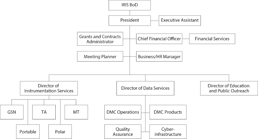
Array Seismic Studies of the Continental Lithosphere (PASSCAL; the world’s largest open access portable geophysical instrumentation center) in collaboration with the New Mexico Institute of Mining and Technology. IRIS also supports polar instrumentation for experiments in Antarctica and the arctic regions. The IRIS data services directorate supports the world’s largest broadband waveform seismic data center.
IRIS utilizes a university consortium governance model with a flat organizational structure devoted to facility operations (see Figure 3.1). IRIS program managers, directors, and staff do not engage in research, but program managers and directors have deep technical domain knowledge and program management experience. Detrick described IRIS as a cost-effective organization due to its leveraging of scientific and technical expertise in the academic community through sub-awards for some IRIS facilities. Approximately half of the IRIS annual budget goes to 12 major sub-awards. Additionally, IRIS remains lean by sharing facilities where feasible. For example, IRIS shares some office and warehouse space with UNAVCO and houses its data management center servers and storage devices at the University of Washington (with backup at the Lawrence Livermore National Laboratory). By outsourcing administrative functions such as human resources, payroll, information technology, and its retirement plan, IRIS maintains an overhead rate of 25 percent.
Detrick described IRIS’s community governance structure and interaction with facility users (see Figure 3.2 presented by Detrick). The 9-member Board of Directors is elected by the 126 member institutions. Members typically serve 3-year terms. Through service on standing or advisory committees established by the IRIS Board of Directors, community members provide oversight of facility operations, guidance on annual budget priorities, and strategic planning. The committees meet twice per year and may have
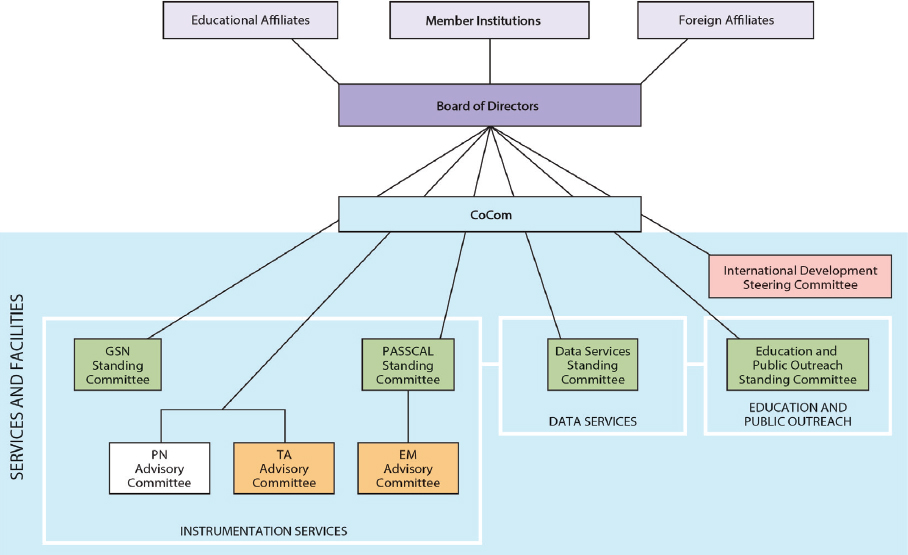
working groups or advisory committees to help them. Governance issues that crosscut different facilities are addressed by a coordinating committee comprised of project managers and standing committee chairs. The IRIS Board of Directors and its standing committees identify longer-term goals and priorities for the facilities that IRIS operates, and IRIS staff implement those plans and priorities.
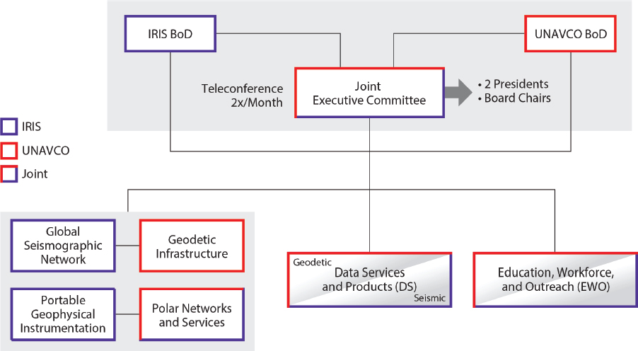
Detrick described that IRIS and UNAVCO are experimenting with a coordinated program governance and management structure as part of the new awards for SAGE and Geodetic Facility for the Advancement of Geoscience (GAGE). Under the joint management structure, IRIS and UNAVCO operate independently under separate cooperative agreements with NSF, but a newly established Joint Executive Committee considers issues that affect both facilities (e.g., planning the annual SAGE/GAGE workshop, or reviewing SAGE and GAGE data services). Figure 3.3, presented by Detrick, shows the organization of the joint governance model and its committees. The joint governance model includes six standing committees, one for each major SAGE or GAGE program. Some of the standing committees include members from a single facility when there is little or no overlap of interests across facilities. Other standing committees include members from both when there is overlap (e.g., data services, education, workforce and outreach). The joint structures are still too new, according to Detrick, to determine the effectiveness of the approach.
Detrick stated that he believes the success of IRIS is due to its model of community governance. The model ascribes a sense of ownership to the research community, and
the sense that community needs and priorities are met. According to Detrick, community governance avoids the perception of conflict of interest that some may sense in facilities housed at a single university (i.e., because facility managers at IRIS are not competing for use of the facility for their own research). Detrick also stated that the governance structure includes early-career investigators in facility governance, integrating them into the seismic community and, according to Detrick, grooming them to be future leaders in the field. Consortium activities such as workshops, internships, and online training and networking helps to build a large and vibrant seismic community. He cited 35 years of NSF facility operation, an international reputation as a model facility operator, the on-time and on-budget construction and operation of EarthScope’s U.S. Array facility, the construction of the world’s largest repository for waveform, broadband seismic data, and the wide use of IRIS educational and public outreach products and activities as examples of IRIS’s good track record.
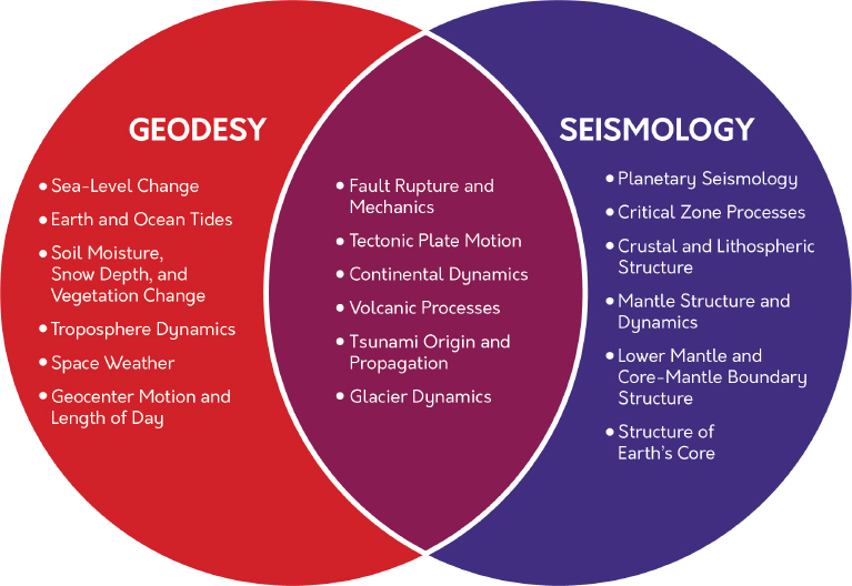
Figure 3.4, presented by Detrick, shows the breadth of science topics that the SAGE and GAGE facilities support. Detrick noted that while there are some research areas of common interest to the IRIS and UNAVCO communities, there are also many research areas only of interest to one community or the other. As a result, according to Detrick, the seismic and geodetic communities remain relatively distinct, and the broadly different research approaches used by these communities need to be considered when contemplating the future management of seismological and geodetic facilities. He stated that it would be challenging for any single facility, regardless of the management structure employed, to continue to provide the domain expertise typical of IRIS and UNAVCO.
UNAVCO MANAGEMENT OF THE GEODETIC FACILITY FOR THE ADVANCEMENT OF GEOSCIENCE (GAGE)
M. Meghan Miller, UNAVCO
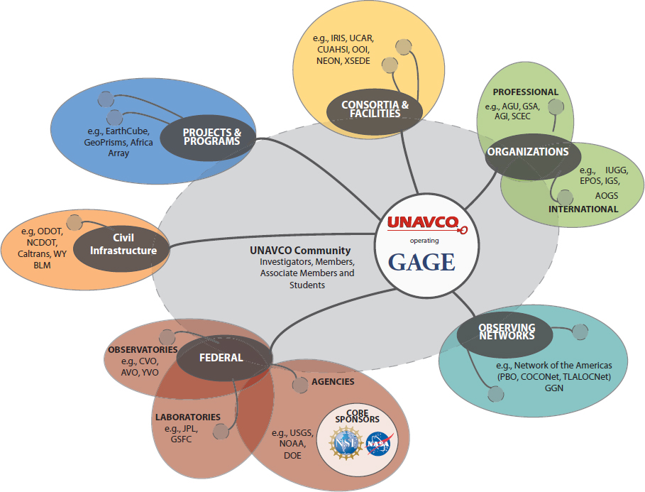
Meghan Miller, president of UNAVCO, described the UNAVCO management of NSF’s GAGE facility. Support for GAGE is received primarily from the Division of Earth Sciences (EAR) at NSF, but the program also receives support from the NSF Office of Polar Programs and the National Aeronautics and Space Administration. The UNAVCO mission, according to Miller, is to facilitate geoscience research and education using geodesy. UNAVCO is a university consortium community with 120 U.S. member institutions, 111 international member institutions, and other associate member institutions. The consortium also includes a research and education community of diverse investigators reliant on technology and innovation in geodesy. She described a mission-driven organization that is an active partner in dozens of national and international projects that augment UNAVCO core funding. UNAVCO is a federally compliant 501(c)(3) nonprofit corporation incorporated in the state of Colorado.
UNAVCO capabilities, according to Miller, include construction and operation of new geodetic networks (e.g., Global Positioning System [GPS] and Global Navigation Satellite System [GNSS] networks); engineering, instrumentation, development and testing, and data services for NSF-funded investigators; operations to support NSF-funded community GNSS networks and the National Aeronautics and Space Administration’s (NASA’s) Global GNSS network; and planning support for principal investigators (e.g., to advance geoscience education, geodesy community engagement, and investigator proposals). She noted that priorities at UNAVCO are set based on collaboration with stakeholders.
Figure 3.5 is a schematic provided by Miller showing the various stakeholder pathways for input, which begin as early as strategic planning. To set priorities, UNAVCO works within the GAGE governance structure, with GAGE advisory committees, UNAVCO sponsors and other federal stakeholders, participants in UNAVCO workshops, and with partners in community projects and programs, among others.
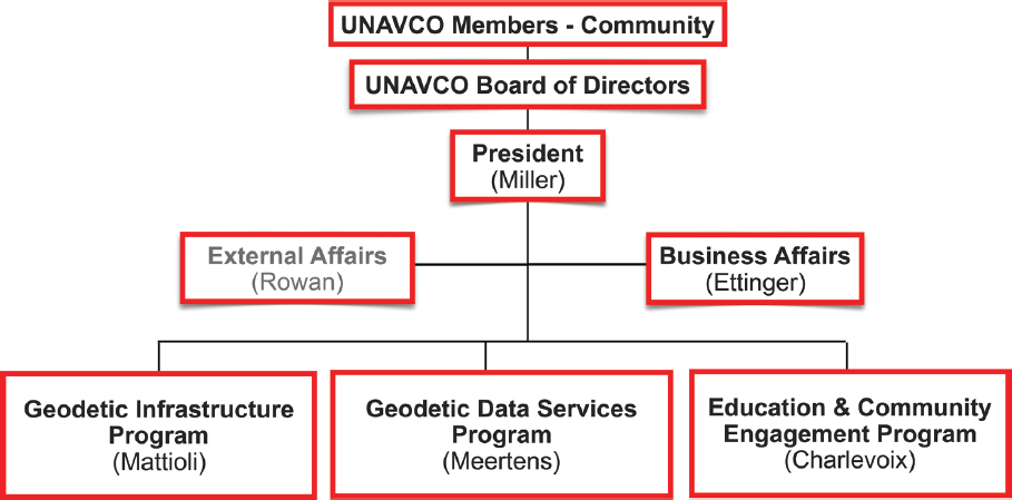
In response to the prompting question related to accountability in management, Miller presented a high-level organization chart that demonstrates UNAVCO’s up-line management (see Figure 3.6). The three programs within UNAVCO—the Geodetic Infrastructure Program, the Geodetic Data Services Program, and the Education and Community Engagement Program—report directly to Miller as the UNAVCO president. The president reports to the community member-elected Board of Directors. Historically, according to Miller, the governance structure has mirrored the management structure. There are advisory committees to each of the three UNAVCO programs that report to the Board of Directors and provide advice to the programs through the president. An Audit and Finance Committee and a Membership Committee also report directly to the Board of Directors, with the Finance committee providing oversight for fiscal compliance. The Western North America Interferometric Synthetic Aperture Radar Consortium (WInSAR) executive committee acts as an advisory committee, reporting directly to the UNAVCO Board of Directors.1
Miller also referred to the new joint governance structure with IRIS that Detrick described in his presentation. She added that IRIS and UNAVCO were also transitioning to joint management of some functions common to both facilities. UNAVCO and IRIS are exploring ways to increase interaction between the two facilities without losing the deep domain expertise necessary to each.
According to Miller, UNAVCO has changed organizational homes twice and has a history of adapting its management to suit community needs. In 1984, the geodesy community first organized as the University Navstar Consortium (UNAVCO) under the Cooperative Institute for Research in Environmental Sciences (CIRES) at the University of Colorado Boulder. The organization then operated under the Office of Programs at the University Corporation for Atmospheric Research (UCAR) from 1991-2003. UNAVCO incorporated as an independent 501(c)(3) nonprofit in 2001 and UCAR/UNAVCO and
___________________
1 WInSAR operates as a consortium within a consortium (UNAVCO). UNAVCO provides operational support to WInSAR, including membership administration, financial management, data management and archiving, and software tools.
the private UNAVCO both existed until 2003. At that time, staff transitioned fully to UNAVCO, Inc. UNAVCO support of the Plate Boundary Observatory (PBO) construction for EarthScope2 occurred under its own leadership. Miller mentioned that in 2011, the UNAVCO and PBO structures were realigned into a single facility organized around geodetic infrastructure, geodetic data services, and community engagement programs. This decision was made by Miller as president of UNAVCO because she felt that multiple data and instrumentation sites were not necessary, there was greater potential for synergies with this realignment, and the structure was better suited to serve the community in the long-term.
Miller described how the work of UNAVCO is prioritized through the UNAVCO governance and management structures, and that those structures are, in turn, aligned to support existing observing capabilities as well as new observational and cyberinfrastructure innovation. Priorities are also established based on GAGE facility requirements to enable stakeholder discovery through observations, data services, and education, workforce, and outreach activities. However, budgets do not keep up with needs, and compromises are necessary in the interest of science, she stated. Miller described other feedback loops, such as those between the evolving geodetic capabilities and the science questions that result from new observations, development and testing of new instruments, deployment of new technologies, support for innovative observations and data services, and cultivation of the science community. New tools, according to Miller, have led to unexpected observations and important discoveries. Miller noted that given the rapidly evolving nature of geodesy, an important aspect of UNAVCO priority setting is proactively managing emerging technologies in the best interest of science and stakeholder needs. Governance-developed priorities are informed by UNAVCO staff and other domain experts, but constrained by budgets.
Miller mentioned that UNAVCO functions through a passionate and expert staff. However, UNAVCO does experience high staff turnover because of competition for human capital. Limited resources make it challenging to retain talent, to accommodate the increasingly varied demands of stakeholders, to maintain aging instrument systems, and to reduce technical debt. Miller did describe a landscape that is broad and active based on the large number of active awards, sub-awards, memorandums of understanding, or other former relationships. The mission of UNAVCO compels UNAVCO management, partners, and stakeholders to develop strategies to identify new opportunities in geodetic observing and cyberinfrastructure capabilities for science, for mission-oriented federal agencies, and beyond.
MODERATED DISCUSSION WITH IRIS AND UNAVCO MANAGEMENT AND BOARDS OF DIRECTORS
The workshop planning committee asked IRIS and UNAVCO staff and Boards of Directors to join Miller and Detrick for a panel discussion. Table 3.1 is a list of those on the panel, and their biographies are presented in Appendix C. Workshop participants were invited to ask the panel questions and engage in discussion. The sections below summarize the major themes discussed during this session.
___________________
2 See https://www.unavco.org/projects/past-projects/pbo/pbo.html.
Table 3.1 IRIS and UNAVCO Panelists
| IRIS | UNAVCO |
|---|---|
| Robert Detrick, President | Meghan Miller, President |
| Doug Wiens, Chair, Board of Directors | Glen Mattioli, Director of Geodetic Information |
| Bob Woodward, Director, Instrumentation Services | Chuck Meertens, Director of Geodetic Data Services |
Balancing Organizational Vision Within NSF Contractual Requirements
In response to a question about how to balance organizational visions developed independently of contractual agreements with sponsors, Detrick responded that the vision of the IRIS community far exceeds available resources, especially those from core awards. Detrick opined that IRIS needs to look beyond the basic 5-year NSF award to manage and operate the facility, and pursue new initiatives that are not funded through their core award. This might be, for example, through other NSF divisions and beyond NSF.
Managing Sub-Awards
IRIS sub-awards, according to Detrick, are monitored and annually assessed for performance. If performance is determined insufficient, IRIS may terminate a sub-award agreement and choose another awardee, generally through open solicitation. The three largest sub-awards are periodically re-competed, although these might require specific technical capabilities and expertise that few organizations could provide. Miller described a different process at UNAVCO. UNAVCO sub-awards are mostly for data processing and instrumentation, but UNAVCO uses sub-awards to bring in new capabilities that could be used broadly by the investigator base under the umbrella of a single geodetic capability. Detrick reminded the workshop participants of the benefits of leveraging funds through sub-awards and academic partnerships—sub-awardees often have other sources of funding so staff are not necessarily 100 percent supported by IRIS or UNAVCO funds. Sub-awardees bring additional expertise to the IRIS and UNAVCO facilities, and often bring resources from their parent institutions with them at no cost to the sub-awardees or to IRIS or UNAVCO. Detrick cited the construction of a major warehouse at the New Mexico Institute of Mining and Technology, and facilities made available for instrument testing at the University of California, San Diego, as an example of such a resource.
Governance of Innovation
The committee structure established as part of IRIS governance has been an effective innovation driver, according to Woodward. The committees review budgets and work directly with facility staff to identify which capabilities and technologies to prioritize. IRIS staff, as domain experts, also interact broadly with the research community and contribute to prioritization discussions. Innovations may then be incorporated into facility capabilities, and often quickly. Detrick described how until 3 years ago, IRIS had no nodal (“coffee
can”) sensors,3 but in response to community need identified through the governance structure, IRIS now has around 500 of those sensors, which are in great demand, and expects IRIS to obtain 1,500 sensors total. Mattioli described that governance is pushing innovation at UNAVCO in two new directions: (1) moving from a GPS-only sensor platform toward a multi-constellation GNSS platform; and (2) using unmanned aerial vehicles for high-precision geodetic imaging. UNAVCO is looking for support for these initiatives. Wiens added that the community governance model helps avoid expenditures on engineering improvements that may not represent the optimal use of funds from a scientific standpoint. Wiens also suggested that IRIS responsiveness to community demands for innovation is greater than that of other facilities under different governance structures because IRIS managers answer to the IRIS Board of Directors.
Maintaining Technical Expertise
In response to a question about how IRIS and UNAVCO maintain their unique expertise required to excel, Meertens said that UNAVCO provides a rich experience that long-time employees appreciate. He admitted that retaining younger people is a bigger challenge. UNAVCO has been strategizing ways to manage the environment with greater agility, allow for more collaborative research, and use innovative approaches to help attract and retain younger staff. Both UNAVCO and IRIS, according to Meertens, are working with the NSF Extreme Science and Engineering Discovery Environment (XSEDE)4 resource on several projects to enhance cyberinfrastructure, and UNAVCO is working with XSEDE for system administration support and to move more to the Cloud. IRIS and UNAVCO have a joint project funded by EarthCube.5 Detrick noted that in Seattle, Washington, IRIS has been able to hire people away from large technical corporations because of a preference for the IRIS work environment, in spite of the lower pay.
Availability of Resources to Principal Investigators
In response to a question about availability of instrumentation to principal investigators, Woodward stated that investigators first make an instrument request to the SAGE facility and SAGE provides a letter indicating whether the requested instrumentation is available at the facility. Once funded, the investigator is put on the facility’s schedule, which is based on instrument availability, mostly on a first-come-first-served basis. NSF-funded investigators are given priority over other agencies wanting to use the equipment. No distinction is made on experiments funded by EAR versus other parts of NSF, according to Woodward. New equipment is sometimes purchased if, for example, NSF’s Office of Polar Programs needs equipment in Antarctica during a given field season, but it is in use elsewhere. Under such conditions, funding will be given to purchase new instruments. Mattioli described UNAVCO’s process as similar. UNAVCO has a web-based interface for
___________________
3 These are compact, three-channel, all-in-one sensor and data loggers that IRIS uses for active and short-term passive deployments. See https://www.passcal.nmt.edu/content/instrumentation/sensors/high-frequency-sensors/nodes.
4 XSEDE, housed at Indiana University, is a virtual system that can be used to interactively share computing resources, data, and expertise. See https://www.xsede.org.
investigators to request support. UNAVCO will provide a letter of support, if required, that will also describe the additional funds necessary to procure additional instrumentation. During scheduling, EAR-funded investigators are prioritized first, then NASA, and then other projects. Mattioli says resources are limited for new procurements.
Recapitalization of Equipment
When asked about long-term management challenges for IRIS, Woodward responded that recapitalization of the $80-$100 million instrument fleet maintained on behalf of the research community was a major challenge. Many of the instruments have been in operation for 12-14 years and the base award for SAGE does not include significant funds for recapitalization. IRIS has had some success obtaining recapitalization funds from other U.S. agencies that recognize the value of collaboration with the NSF-funded facility. Mattioli described UNAVCO as critically underfunded to recapitalize existing networks and pools of instruments available to principal investigators. The current UNAVCO award, according to Mattioli, allows for a limited amount of equipment replacement.


