


Below is the uncorrected machine-read text of this chapter, intended to provide our own search engines and external engines with highly rich, chapter-representative searchable text of each book. Because it is UNCORRECTED material, please consider the following text as a useful but insufficient proxy for the authoritative book pages.
6 This chapter documents the information collected from the literature review of technologies for highway construction delivery. The objective of this chapter is to set the background and context for the findings from the survey and the case examples presented in Chapters 3 and 4, respectively. This chapter discusses a range of new and innovative technologies that are used in the construction industry. This chapter focuses on the following technologies used in construc- tion: (1) visualization and modeling, (2) interconnected technologies, (3) safety technologies, (4) instrumentation and sensors, and (5) unmanned aircraft systems (UASs). Visualization and Modeling Digital solutions for construction delivery focus on real-time sharing of information that helps to achieve transparency and collaboration, improved quality control, timely risk assess- ment, and cost-effective results (Avsatthi 2017). The construction industry has displayed little productivity growth during the past two decades (McKinsey Global Institute 2017a). However, a direct correlation exists between the extent that an industry digitizes itself and productivity improvements. For example, adopting effective practices to infuse the use of technologies, new materials, and advanced automation can increase productivity by 6% to 10% and result in cost savings of 4% to 5% (McKinsey Global Institute 2017b). Continued reliance on paper-based processes during project development and delivery (e.g., design, procurement, and construction progress reports) is a contributing factor to low productivity in construction and impedes innovation (Pistorius 2017). A lack of digitalization causes delays in information sharing that may lead to challenges and errors in data analysis, progress reports, and other project documentation. Table 2 summarizes some general digital solutions for delivering construction projects. State DOTs have traditionally administered contracts and managed construction of high- way projects using paper-based documentation systems. However, digital technologies are increasingly used in highway construction. In 2015, the FHWA EDC-3 initiated e-construction technologies including digital electronic signatures, electronic communication, secure file sharing, version control, mobile devices, and web-hosted data archival and retrieval systems to improve construction documentation management. EDC-3 found that, in addition to time and cost savings, the e-construction process allows faster approvals, increased accu- racy, and enhanced document tracking, all while increasing transparency (FHWA 2017). Building on the success of EDC-3, FHWA EDC-4 promotes e-construction as a practice that is used to help deliver transportation improvements smarter and faster. The FHWA EDC-4 highlights that âpaperless technologies enhance partnering among stakeholders on construction projects, improving communication and workflows while streamlining project delivery.â C H A P T E R 2 Literature Review
Literature Review 7 A wide range of technologies exists that directly link to digitalization and visualization. This section discusses the following visualization and modeling technologies and applications: ⢠LiDAR, ⢠Building information modeling (BIM), and ⢠Virtual reality and augmented reality. LiDAR LiDAR is an optical remote sensing technology typically used for measuring the distance between a surface and its sensing units. LiDAR is becoming increasingly popular to create accu- rate 3-D models of any surface within visual sight of the sensing unit. Many state DOTs across the United States have adopted practical uses of LiDAR technology for highway construction- related applications. Table 3 shows a summary of common technologies used to survey a site. There are three main LiDAR applications: (1) static LiDAR (e.g., a system mounted at a single location), (2) mobile LiDAR (e.g., a system can be attached to a vehicle such as a truck or unmanned aircraft), and (3) airborne LiDAR (e.g., a system is attached to an aircraft) (Maier et al. 2018). The static LiDAR collects highly accurate data, but is comparatively much slower than mobile and airborne LiDAR and exposes DOT workers to more traffic and hazard risk. Both mobile and airborne LiDAR provide mapping-grade accuracy at high rates of travel. The mobile LiDAR application involves digital highway measurement vehicles; uses LiDAR, inertial navigation systems, and GPS; and measures pavement markings and pavement cross sections, which includes shoulders and curbs (Ogle 2007). The airborne LiDAR system collects data when traveling at 115 miles per hour at an elevation of about 1,640 feet (Dye Management 2014). Table 4 shows typical project characteristics for using the different LiDAR methods. Process Description Design management ⢠View drawings and 3-D models on site using mobile devices ⢠Update blueprints in the field with markups, annotations, and hyperlinks Scheduling ⢠Create, assign, and prioritize tasks in real time ⢠Track progress online ⢠Immediately distribute work plans and schedule to all workers ⢠Issue mobile notifications to all subcontractors Materials management ⢠Identify, track, and locate materials, spools, and equipment across the entire supply chain Crew location ⢠Provide real-time status updates on total crew deployed across work fronts, number of active working hours, entry into unauthorized areas, and others Quality control ⢠Inspect remote site using pictures and tags shared through mobile device applications ⢠Update and track live punch lists across projects to expedite project close-out Contract management ⢠Update and track contract-compliance checklists ⢠Maintain standardized communication checklists ⢠Provide updated record of all client and contractor communications Performance management ⢠Monitor progress and performance across teams and work areas ⢠Provide automated dashboards created from field data ⢠Offer staffing updates and past reports generated on handheld devices Document management ⢠Upload and distribute documents for reviewing, editing, and recording all decisions ⢠Allow universal project search across any phase Source: Adapted from Agarwal et al. 2016. Table 2. General digital solutions for construction delivery processes.
8 Emerging Technologies for Construction Delivery One of the key benefits of LiDAR technology is that its acquired data are useful for sev- eral applications. The collected data using LiDAR can be mined for additional information to serve as suitable input for different applications. NCHRP Research Report 748: Guide- lines for the Use of Mobile LIDAR in Transportation Applications (Olsen et al. 2013) shows various applications of using mobile LiDAR related to construction delivery, including the following: ⢠As-built and maintenance documentation. The data are integrated into a centralized database that is continuously updated for future planning and construction. ⢠Pavement smoothness and quality determination. Data collected at higher resolutions can be used to evaluate pavement smoothness and quality. ⢠Construction automation and quality control. Change detection and deviation analysis soft- ware uses design models to identify deviations from LiDAR point clouds for construction quality control. ⢠Performing quantity take-off. LiDAR data are used to determine lengths, areas, or volumes of construction quantity. ⢠Virtual and 3-D design. LiDAR data can be used for clash detection by checking for inter- sections of proposed objects with existing objects modeled in the point cloud. ⢠Inspections. LiDAR can provide overall geometric information and an overall condition assessment. measurement ⢠Requires on-site personnel ⢠Used for on-site checks before performing work GPS ⢠Uses GPS coordinates ⢠Ineffective when blocking ⢠Used when there is a need for high accuracy in small open sites Photogrammetry ⢠Uses high-resolution images ⢠Requires postprocessing to convert information to usable data ⢠Used when there is a need for high accuracy over large sites LiDAR ⢠Uses optical lasers to detect thousands of points per second with a native 3-D model output ⢠May have issues with some steep terrains Source: Adapted from Agarwal et al. 2016. Tool Description Electronic distance ⢠Most commonly used Table 3. Technologies used for site surveys. ⢠Mainline lengths > 1,300 ft ⢠Large areas and wide ⢠corridors ⢠Large bridge replacements ⢠Variable terrain ⢠Rural reconstructions ⢠Areas with limited foliage ⢠Long rural corridors ⢠High-speed corridors ⢠Corridors with high volumes ⢠Multilevel interchanges ⢠Resurfacing projects with cross-slope or super-elevation corrections ⢠Data collection time constraints ⢠Mainline lengths < 1,300 ft ⢠Small areas ⢠At-grade intersections ⢠Low-volume and low- speed roadways ⢠Flat terrain ⢠Small bridge replacements ⢠Urban resurfacing projects with drainage or cross-slope repairs ⢠Interstate widening Source: Adapted from Maier et al. 2018. Aerial LiDAR Mobile LiDAR Static LiDAR Table 4. Project characteristics for using different LiDAR methods.
Literature Review 9 Building Information Modeling BIM is the intensive process of developing and using a computer-generated model to simulate the phases of a construction project digitally. The model can include simulation of planning, design, construction, and maintenance and operation of facilities and structures. BIM models have many applications, and purposes, such as visualizations through 3-D rendering, can be generated, while construction plans and shop drawings can be extracted and building codes reviewed through analysis of object parameters. Figure 1 shows BIM functionalities to integrate design, cost, and schedule with a 3-D output. According to Dodge Data and Analytics (2014), Figure 2 shows the level of adoption of BIM in infrastructure projects in different sectors from 2009 to 2013. Specifically, the use of BIM more than doubled between 2009 (20%) to 2013 (56%) for bridges, roads, and highway projects. FHWA emphasized 3-D engineered models for design and construction starting with EDC-2 and continued this emphasis with EDC-3. The EDC initiatives found that 4-D and 5-D modeling efforts facilitated communication between multiple stakeholders and allowed Design (3D) Budget (5D) 3-D Model linked to schedule 3-D model elements used to develop budget Information included in 3-D Model: Geometry, spatial data, specifications, aesthetics, thermal properties, acoustic properties, etc. Schedule (4D) Figure 1. BIM functionality (adapted from Agarwal et al. 2016). Dams 2009 0% 20% 40% 60% 2011 2013 Waste Rail, Transit, Aviation Energy Parks and Recreation Bridges, Roads, Highways Water 44% 32% 39% 39% 24% 35% 30% 20% 20% 19% 23% 15% 20% 15% 59% 58% 59% 58% 56% 56% 57% Figure 2. Level of BIM adoption for infrastructure projects (adapted from Dodge Data & Analytics 2014).
10 Emerging Technologies for Construction Delivery contractors to streamline construction schedules, which can produce significant cost and schedule advantages (FHWA 2013b). Some key benefits realized from the use of 3-D models include ⢠Improved project delivery by accelerating construction progress, making construction more accurate and cost-effective, and increasing safety on the job site; ⢠Improved communication between key stakeholder communities (e.g., owner, public, consultants, contractor, utility companies, prefabricators, and material suppliers); ⢠Enhanced clash detection and identification of possible errors and inconsistencies in design before construction; and ⢠Improved visualization of subgrade features and potential utility conflicts (FHWA 2013b). Then, NCHRP Research Report 831: Civil Integrated Management (CIM) for Departments of Transportation noted the perceived benefits and challenges from the use of BIM for highways (OâBrien et al. 2016). As shown in Figure 3, the perceived benefits of BIM include (1) promot- ing early decision-making, (2) mitigating risk and enhancing validation of the project, and (3) providing better means to communication throughout the project. Figure 4 indicates that Figure 3. Perceived benefits of BIM (OâBrien et al. 2016). Figure 4. Perceived challenges of BIM (OâBrien et al. 2016).
Literature Review 11 the challenges of BIM are (1) cost associated with BIM adaptation, especially setup costs if multiple technologies are used; (2) more work and fees at risk early in the project develop- ment process; and (3) lack of buy-in. These benefits and challenges of BIM vary and occur on a project-by-project basis. BIM practices have been successfully used in several projects, but they are not widely adopted in transportation projects of all sizes and complexity. Further, the models produced using BIM are for discretionary use and are limited in their use as contract documents. Virtual Reality and Augmented Reality Virtual reality (VR) technology superimposes a computer-generated image to give a user a view of the real world and thus provides a composite view that isolates the userâs sensory receptors (eyes and ears) from the real physical world (Behzadan et al. 2015). VR has been used within the construction industry for many applications, such as design and collabora- tive visualization, and as a tool to improve construction processes. VR forms a good route for building design as it provides a 3-D visualization that can be manipulated in real time and used collaboratively to explore stages of the construction process (Whyte and Nikolic 2018). In con- trast to VR, augmented reality (AR) creates an environment where a user has a superimposed computer-generated view of a real-world scene. AR consists of a live, imitative version of the real worldâwith the capacity to add certain elements to the simulated landscape. AR preserves the userâs awareness of the real environment by compositing the real world and the virtual contents (Azuma et al. 2001). A VR/AR system, typically referred to hardware components, software, and algorithms, has various applications in the construction industry. Rankohi and Waugh (2013) showed that field workers and project managers have a high interest in using VR/AR technologies during the project construction phase mainly to monitor progress and to detect defects or clashes in the placement of work. Shin and Dunston (2008) discussed the potential of AR applications in eight work tasks of a construction project: layout, excavation, positioning, inspection, coor- dination, supervision, commenting, and strategizing. A VR/AR technology can be integrated with BIM to create a seamless interaction between the design and the construction work (Pistorius 2017). Researchers show that VR/AR allows users to find the difference between an as-designed 3-D model and an as-built facility (Georgel et al. 2007). Other researchers imple- mented a system for visualizing performance metrics to represent progress deviations through the superimposition of 4-D as-planned models over time-lapsed real job site photographs (Golparvar-Fard et al. 2009). Many VR/AR applications focus on construction safety, which includes safety planning (e.g., hazard identification), safety training and education, and safety inspection and instruction. For example, Albert et al. (2014) developed a system for augmented virtuality environments (SAVEs) to detect hazard stimuli in dynamic construction environments effectively. SAVEs was designed to immerse trainees in a hyperrealistic, 3-D environment including functional- ity to assess worker performance of hazard recognition, to provide feedback, and to equip workers with a holistic approach for hazard stimuli detection using retrieval mnemonics. Although VR/AR technologies have several applications to improve construction performance and received considerable attention within research communities, these technologies are still relatively new in the transportation construction industry. In fact, Pistorius (2017) indicated that the construction industry has so far only âdabbled in the use of VR/AR to aid construc- tion projects.â However, as cheaper and higher-quality 3-D options come to market, many expect that VR/AR technologies will rapidly increase in use for construction projects in the near future (Pistorius 2017).
12 Emerging Technologies for Construction Delivery 3-D Printing 3-D printing is a process to create 3-D objects from a digital file. The process includes laying down successive layers of thin horizontal cross sections until the entire object is completed (Pistorius 2017). Current materials in use for 3-D printing technology include plastics, glass, ceramics, liquids, organic materials, cement, bituminous concrete, and metal powders. There are several applications for the use of 3-D printing technology. For example, creating models of buildings, prototypes, and smaller parts can be 3-D printed (Pistorius 2017). 3-D printers can also create construction modules off-site that are then shipped to the construction site. Further, large construction structures such as buildings or bridges can be 3-D printed with supersize printers and specialized materials. Figure 5 shows an example of using 3-D printers for a wall structure. Benefits associated with the use of 3-D printing for construction include ⢠Increasing productivity, accuracy, and efficiency; ⢠Lowering labor and supply costs; ⢠Reducing the amount of waste; ⢠Creating safer work environments; and ⢠Reducing health and safety risks (Pistorius 2017). Safety enhancement applications of VR/AR: ⢠Virtual and augmented reality allows costly mistakes to be identified and rectified before they occur by being able to visualize how something will work, without the costs and hazards of physical trial and error. ⢠Field conditions can be communicated in real time to people who are not physically present on site. ⢠Possible dangerous situations can be explored without subjecting people to dangerous environments. ⢠These aid in safety training for new employees. Dangerous and hazardous situations can be simulated, and employees trained to deal with them, without having to do the training in a real environment. (Pistorius 2017) Figure 5. 3-D printed wall (3-D Printhuset 2017).
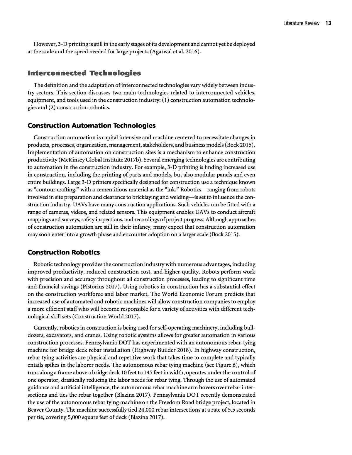
Literature Review 13 However, 3-D printing is still in the early stages of its development and cannot yet be deployed at the scale and the speed needed for large projects (Agarwal et al. 2016). Interconnected Technologies The definition and the adaptation of interconnected technologies vary widely between indus- try sectors. This section discusses two main technologies related to interconnected vehicles, equipment, and tools used in the construction industry: (1) construction automation technolo- gies and (2) construction robotics. Construction Automation Technologies Construction automation is capital intensive and machine centered to necessitate changes in products, processes, organization, management, stakeholders, and business models (Bock 2015). Implementation of automation on construction sites is a mechanism to enhance construction productivity (McKinsey Global Institute 2017b). Several emerging technologies are contributing to automation in the construction industry. For example, 3-D printing is finding increased use in construction, including the printing of parts and models, but also modular panels and even entire buildings. Large 3-D printers specifically designed for construction use a technique known as âcontour crafting,â with a cementitious material as the âink.â Roboticsâranging from robots involved in site preparation and clearance to bricklaying and weldingâis set to influence the con- struction industry. UAVs have many construction applications. Such vehicles can be fitted with a range of cameras, videos, and related sensors. This equipment enables UAVs to conduct aircraft mappings and surveys, safety inspections, and recordings of project progress. Although approaches of construction automation are still in their infancy, many expect that construction automation may soon enter into a growth phase and encounter adoption on a larger scale (Bock 2015). Construction Robotics Robotic technology provides the construction industry with numerous advantages, including improved productivity, reduced construction cost, and higher quality. Robots perform work with precision and accuracy throughout all construction processes, leading to significant time and financial savings (Pistorius 2017). Using robotics in construction has a substantial effect on the construction workforce and labor market. The World Economic Forum predicts that increased use of automated and robotic machines will allow construction companies to employ a more efficient staff who will become responsible for a variety of activities with different tech- nological skill sets (Construction World 2017). Currently, robotics in construction is being used for self-operating machinery, including bull- dozers, excavators, and cranes. Using robotic systems allows for greater automation in various construction processes. Pennsylvania DOT has experimented with an autonomous rebar-tying machine for bridge deck rebar installation (Highway Builder 2018). In highway construction, rebar tying activities are physical and repetitive work that takes time to complete and typically entails spikes in the laborer needs. The autonomous rebar tying machine (see Figure 6), which runs along a frame above a bridge deck 10 feet to 145 feet in width, operates under the control of one operator, drastically reducing the labor needs for rebar tying. Through the use of automated guidance and artificial intelligence, the autonomous rebar machine arm hovers over rebar inter- sections and ties the rebar together (Blazina 2017). Pennsylvania DOT recently demonstrated the use of the autonomous rebar tying machine on the Freedom Road bridge project, located in Beaver County. The machine successfully tied 24,000 rebar intersections at a rate of 5.5 seconds per tie, covering 5,000 square feet of deck (Blazina 2017).
14 Emerging Technologies for Construction Delivery FHWA published Automated Machine Guidance with Use of 3-D Models (AMG) in 2013 to explore the use of machine control guidance for highway projects (FHWA 2013b). AMG involves using construction equipment (e.g., bulldozers, blades, scrapers, and paving machines) mounted with onboard computers to provide horizontal and vertical guidance in real time to construction equipment operators (White et al. 2018). AMG uses positioning devices such as GPS, total stations, and rotating laser levels, singly or in combination, to determine and con- trol the real-time position of construction equipment. The onboard computer combines input data with engineered digital terrain and design models to provide output to video screens and hydraulic systems, all to assist the equipment operator in constructing the project more effi- ciently (California Department of Transportation 2013). Figure 7 shows an example of an AMG device used at the California Department of Transportation. FHWA notes that the use of AMG improves construction efficiency, quality, and safety while reducing schedule, cost, and the environmental impacts. Typical benefits of AMG follow: ⢠Reduced construction costs through (1) decreased costs of maintenance and fuel, (2) decreased agency support costs, (3) improved machine productivity, (4) lowered operating costs, and (5) increased potential for electronic as-built documentation; ⢠Reduced project schedules through (1) increased equipment productivity, (2) reduced time for survey and staking, and (3) improved equipment logistics arising from less rework; Figure 6. Autonomous rebar tying machine. (Photo courtesy of Advanced Construction Robotics, Inc.). Figure 7. Automated machine guidance device (California Department of Transportation 2013).
Literature Review 15 ⢠Improved quality through (1) more precise levels of accuracy over conventional construc- tion methods, (2) increased control of elevation and cross-slope for asphalt paving, (3) fewer errors requiring rework, (4) decreased margin of error, (5) increased calculation accuracy for quality assurance and quantity calculations, and (6) increased efficiency in calibration and control of paving equipment by total station compared with string line and level; and ⢠Improved safety through (1) reduced need for elimination of string lines for improved worker safety, and (2) fewer field personnel exposed to heavy equipment and potential back-over/ run-over incidents (White et al. 2018). [AMG technology] is constantly changing and new implementation strategies are being used by contractors. AMG is a downstream application of enhanced data from 3-D models that can provide benefits such as reduced costs and faster construction, thus minimizing impacts on the driving public and providing benefits to all key stakeholders. (White et al. 2018) Safety Technologies Safety is a primary concern of all state DOTs, and therefore the DOT and contractors imple- ment safety technologies to protect construction workers and motorists in work zones. Common safety technologies include WZIAs, wearable protection devices, a proximity warnings system, dynamic message signs, and variable speed zones. Although many technologies contribute to highway construction safety, this section discusses the following three technologies: ⢠WZIAs, ⢠Wearable protection technologies, and ⢠Variable speed limits and dynamic message signs. Work Zone Intrusion Alarm Systems WZIA technology is a type of safety system that alerts work zone workers and enables an escape time in the event of errant vehicles deviating into the work zone (Gambatese et al. 2017). WZIA systems are installed upstream of a work zone to create a buffer area in front of the active work (Minnesota DOT 2015). These systems improve on existing work zone signage, which intends to provide safety to workers, allow sufficient space for roadway work, and provide signs and messaging systems that improve roadway safety and inform motorists. WZIA offers an alert to roadway workers when an unauthorized vehicle enters the work zone and typically consists of static signing, detection devices, dynamic message signs, and an alarm or another notification device. Figure 8 shows a typical WZIA system. The main benefits of a WZIA system include reducing the risk of injury or death by providing advanced warning to workers and equipment operators of an incoming object into the work zone. Additionally, WZIA is a relatively easy system to deploy and retrieve and thereby creates minimal exposure of workers to roadway hazards and causes minimal interruption to construc- tion operations. However, the technology has several limitations. WZIA may sometimes provide sound signals that are not always effective on a construction site where many pieces of equip- ment working together simultaneously may drown out the sound signal (Gambatese et al. 2017). A new advanced intrusion system uses connected devices attached to a workerâs safety vest that vibrate or make a buzzing audio sound when something intrudes into the work zone inadvertently
16 Emerging Technologies for Construction Delivery (Cleaver 2016). The WZI technology, developed from a system used by the U.S. Department of Defense, consists of sensors that include radar, GPS, accelerometers, and gyroscopes, which along with video and wireless connectivity monitors traffic around a work zone and broadcasts a warning when an intrusion occurs. A second sensor located on the workerâs safety vest or hardhat senses the intrusion from the primary sensors and provides a vibration, audio buzzer, lights, or all three to warn a worker who is in the path of an incoming object so that she or he moves away immediately (Cleaver 2016). Currently, the WZI technology system is a proprietary system that has undergone only pilot testing in several states for paving operations at the time of this synthesis. As technologies continue to advance and the system is made available to the public, more state DOTs plan to use the advance safety system on the basis of the success of the pilot tests. Wearable Safety Technologies in Construction Wearable safety technologies refer to personal protection equipment (PPE), health moni- toring, and other devices worn by a person. The information collected from wearable tech- nologies reflects the personâs identity, physical and emotional state, movement or position, as well as other environmental variables. Some benefits of wearable technologies in construction include improving safety, streamlining real-time data collection processes, and enhancing communication. Not only is there a more robust and accurate data set to analyze and utilize on current or future projects, but this technology also frees up the project managerâs time that is traditionally spent in walking the site to conduct headcounts and safety checks. Drawbacks to wearable devices include the high initial cost and the ability of a worker to utilize them correctly and efficiently. Common wearable technologies used at construction job sites follow: ⢠Smart cap. This device uses brain waves to monitor fatigue and send alerts through vibrations and noise to the wearer when a hazard is identified. ⢠Smart vest. With GPS capabilities, wireless and Bluetooth connectivity, vital monitoring, emergency, and built-in alert systems, smart vests offer enormous benefits for all construc- tion workers, not just for highway construction. ⢠Smart helmet. This device includes features such as fall impact detection, emergency alerts, and video recording equipment. When using radio-frequency identification(RFID) technol- ogy, the device warns the worker with an alarm if the individual enters an unsafe zone in proximity to heavy equipment or vehicles. Figure 8. Work zone intrusion alarm system (Minnesota Department of Transportation 2015).
Literature Review 17 ⢠Smart glasses. The device provides workers with the ability to record videos and receive instructions from more skilled workers or managers off-site in real time. Smart glasses also provide advanced technologies to view AR visualizations while a person is on a site. Dynamic Message Signs and Variable Speed Limits Dynamic message signs (DMSs), also known as changeable message signs (CMSs), are traffic control devices used for communicating traffic and work zone warnings, regulations, routing and management, and road and weather conditions information to motorists. DMSs are intended to influence the behavior of drivers by providing real-time traffic-related information (Dudek and Ullman 2002). As critical components of intelligent transportation systems (ITSs) of modern advanced traffic management, DMSs are widely used as an effective means to provide motorists with up-to-date information regarding accidents, congestion, road conditions, and travel time (Ullman et al. 2005). Figure 9 shows an example of a DMS showing information about an Interstate detour. VSL systems adjust the speed in a work zone depending on the conditions. VSL helps to reduce speeds when workers are present, during work activity near travel lanes, and during adverse weather conditions. The systems detect traffic volumes and speeds at various locations with the use of sen- sors and send the data to a computer, which determines the most appropriate message to display. Variable speed limit systems are speed limits that change based on road, traffic and weather conditions. Electronic signs slow down traffic ahead of congestion or weather to smooth out flow, diminish stop and go conditions, and reduce crashes. This low cost, cutting edge technology alerts drivers in real time to sped changes due to conditions down the road. Speeds that are more consistent improve safety by helping to prevent rear end and lane changing collisions due to sudden stops. (Georgia DOT 2018) Instrumentation and Sensors Instrumentation technologies defined in this study involve the use of sensors and devices to monitor and collect data for a specific component of a highway construction project. A wide range of sensors is being used in the construction industry to measure motion, position, and Figure 9. Example of a dynamic message sign (Edara et al. 2014).
18 Emerging Technologies for Construction Delivery identification of people (e.g., construction workers), equipment and tools, vehicles, and materials. The following sections discuss the typical instrumentation and sensor technologies used in highways, including RTK GPS, handheld devices, and ground-penetrating radar. Real-Time Kinematic GPS RTK GPS involves a reference receiver transmitting its raw measurements or observation cor- rections to a rover receiver via data communication link such as ultrahigh frequency radio or cellular telephone. An RTK system typically consists of a base station, one or more rover units, and a data transfer link between the base station and the rover units. In addition to the use of a single base-station receiver, an RTK system can operate by using a network receiver. Rizos (2002) pointed out several advantages of using network-RTK, including ⢠Cost reduction; ⢠Elimination of orbit bias and ionosphere delay; ⢠Better reduction of troposphere delay, multipath disturbance, and observation noise; ⢠Improved accuracy, reliability, and integrity; and ⢠Improved productivity and capacity of GPS positioning. Washington DOT has used RTK systems for the following typical survey operations: ⢠Supplemental control for engineering surveys and construction surveys, ⢠Photo control, ⢠Control of land net points, ⢠Construction survey set-up points, ⢠Topographic survey set-up points, and ⢠Monument surveys (Washington DOT 2005). In Wisconsin Department of Transportation, RTS positioning shall be utilized where grade tolerances are less than +0.1 ft. The index error of the vertical circle of the RTS shall be checked and adjusted as necessary prior to each dayâs operations. Each work session shall begin and end by checking between adjacent control points. (Vonderohe 2009) NCHRP Synthesis 372: Emerging Technologies for Construction Delivery documented the following major benefits of using GPS compared with conventional survey technologies (Hannon 2007): ⢠Faster surveying and mapping for design; ⢠More complete review for constructability before construction starts, allowing for a reduction in errors and omissions; ⢠Elimination of the need for iterative staking of project design layers; ⢠Allowance for the most efficient operation of earthwork machinery; ⢠Greater accuracy and reductions or elimination of finish grading requirements; ⢠Improved as-built/quality assurance/quality control (QA/QC) documentation; ⢠Time savings; and ⢠Labor and equipment resource savings. Handheld Devices A handheld device is defined as âself-contained electronic devices that fit in the palm of a userâs hand and possess, at a minimum, enough computer processing power to surpass the functions of
Literature Review 19 an electronic personal organizer and to run software applications that can extend their built-in functionalityâ (Hannon 2007). The contemporary features of handheld devices include ⢠Localized software applications, ⢠Web/extranet applications, ⢠Mobile phone, ⢠Geographic information system (GIS)/GPS capability, ⢠Sound recording, ⢠Handwriting recording and recognition, ⢠Personal information management, ⢠Text messaging, ⢠Camera, and ⢠Cellular radio/walkie-talkie. The typical benefits of using handheld devices in construction projects are (1) organizing field-generated data better, (2) reducing the cycle time to obtain the data, and (3) reducing the time needed for contract administration (Hannon 2007). Specifically, Haas et al. (2002) found the following benefits of using handheld devices in construction delivery: ⢠Data in the field are handled one time. ⢠Illogical data entry is eliminated. ⢠Entered data are complete. ⢠Pens are easier to use for field personnel who are unfamiliar with keyboards. ⢠Selecting data from predetermined lists speeds up data entry and standardizes the results. ⢠Data integrity is improved by the elimination of sensitive paper-based recording of data. ⢠Less storage space for documents is needed because paper documents are not necessary. ⢠Fewer hard copies of relevant field information are needed because the documents can be accessed on the computer. ⢠Information may be exchanged wirelessly. ⢠Electronic measurement instruments can be incorporated into GPS. Hannon (2007) found that highway agencies often use handheld devices for (1) contract documentation; contract time tracing; material delivery, tracking, and disposition; QA/QC activities; cost tracking; and GPS location and measurement. The most substantial barriers to implementation of handheld devices were the following: ⢠Agency budgetary restrictions, ⢠Software interoperability issues, ⢠End-user technical skill/training, ⢠Screens not viewable in direct sun [e.g., consumer-grade (nonruggedized) video displays are rarely visible in direct sunlight], ⢠Agency procedural issues, and ⢠Unawareness of benefits (Hannon 2007). Ground-Penetrating Radar GPR is a noninvasive sensing technique that has increased in use because of its flexibility and high potential for accurately capturing images of structures and materials. GPR has a wide range of highway construction applications, such as locating underground utilities, unexplored land mines, caves, tunnels, and other unseen objects without excavation or destruction. The GPR data collec- tion process has improved steadily over the years because of advancement in technologies. Goulias and Scott (2015) identified the following typical GPR applications in construction delivery: ⢠Detection of thickness and void size; ⢠Detection of cracking and delamination;
20 Emerging Technologies for Construction Delivery ⢠Detection of corrosion; ⢠Rebar location, depth, and orientation; ⢠Rate of cement hydration; ⢠Density monitoring; and ⢠Drainage-related issues. The main benefits of GPR include ⢠Providing higher precision and accuracy of the condition assessment of key infrastructure components and materials; ⢠Improving the speed of condition assessment; ⢠Reducing monitoring time and cost; ⢠Increasing accuracy of the specific locations where failures occur; ⢠Improving assessment methods of overall condition and more accurate predictions of performance and life cycle; and ⢠Facilitating a method of nondestructive testing for QA/QC activities and forensic investi- gations (Goulias and Scott 2015). Unmanned Aircraft Systems UASs (see Figure 10) are a technology that has a wide range of applications in construc- tion, ranging from monitoring tasks to site surveying and site mapping. The definition of unmanned UAV is any aircraft vehicle that does not rely on a human operator for flight, either autonomously or remotely operated. A UAV, along with other operating and task componentsâincluding the ground control system, communication between the UAV and the operator, camera and video equipment, gimbal, GPS or GIS equipment, electro-optical sensors and scanners, LiDAR, infrared sensors, radars, environmental sensors, and trans- port equipment, as well as data collection and analysis toolsârepresents a UAS (Pecoraro et al. 2017). Figure 10. Unmanned aircraft vehicle (FHWA 2018).
Literature Review 21 Pistorius (2017) and Pecoraro et al.(2017) summarize some applications for using UAVs in construction: ⢠Preproject assessments and project survey data. UAVs can offer aerial images of a project site much more accurately, realistically, and timely than traditional aircraft photographs. ⢠Conducting aircraft surveys and site mapping. UAVs can provide real-time aerial views of key project areas, allowing management, and construction staff to monitor operations and performance, which in turn supports decision-making. ⢠Site inspections and surveillance. UAVs can be used for inspection of bridges, high-tension electric wires, remote sites, and other areas that are difficult to access. UAVs equipped with camera and video equipment provide site security. ⢠Asset tracking and management. UAVs can be used to keep track of the movements of machines and equipment, tools, vehicles, and people. UAVs can monitor workers on site and are a con- venient tool to keep track of how many employees are working in sensitive or hazardous areas. ⢠Monitoring the movement of materials, stockpile reporting, and inventory management. UAVs are used to keep a record of material being delivered, stored, and installed. ⢠Enhanced safety. UAVs can provide real-time data of safety violations and situations that might have an adverse safety impact during the construction process. ⢠Enhanced 3-D modeling. UAV data are acquired in real time and integrated with mapping and BIM models. Several state DOTs have used UASs for various purposes such as surveying sites, tracking construction progress, monitoring roadside environmental conditions, and managing traffic and improving safety (Pecoraro et al. 2017). Virginia DOT demonstrates the feasibility of a UAS for real- time traffic surveillance, monitoring of traffic incidents, signals, and environmental condition assess- ment of roadside areas (Carroll and Rathbone 2002). Ohio DOT uses UAVs to collect data about freeway conditions, intersection movement, network paths, and parking lot monitoring (Coifman et al. 2004). Utah DOT, in collaboration with the Utah Water Research Laboratory at Utah State Uni- versity, used UAVs to take high-resolution pictures of highways to inventory their features and condi- tions in a timely and cost-efficient manner (Barfuss et al. 2012). North Carolina DOT uses UAVs to support construction inspections and perform reconstruction of accident scene to open travel lanes more quickly (FHWA 2018). New Jersey DOT is using UASs to support structural inspections, real-time construction project monitoring, management of traffic incidents, aerial 3-D corridor mapping, assessments of emergency responses, and assessments of traffic congestion (FHWA 2018). For the first time, in May 2018, Kansas DOT began a pilot project to document how UAVs could be used in road design work by employing UAS technology in conjunction with a road project. One of the selected FHWAâs EDC-5 innovations is the implementation of UAVs for highway construction. EDC-5 (FHWA 2018) highlights that âUAS [s] improve operations, construc- tion, inspection, and safety by collecting data needed to design, build, and operate the highway system.â Three main benefits of using UAVs are improved construction safety, accelerated con- struction, and improved asset maintenance. The benefits of unmanned aerial systems (UAS) are wide ranging and impact nearly all aspects of highway transportation. UAS provide high-quality survey and data mapping that can be collected automatically or remotely. Large areas can be mapped relatively quickly in comparison to traditional survey and mapping practices. UAS are also used for survey and imagery as part of emergency response events where traditional surveying and mapping practices are inadequate or impossible. (FHWA 2018)
22 Emerging Technologies for Construction Delivery Chapter Summary The results of the literature review presented in this chapter document innovative and emerg- ing technologies for construction. Chapter 2 provides vital information for understanding the state-of-practice in the use of specific emerging technologies in the delivery of highway con- struction projects. The key concepts of the five main types of technologies used in construc- tionâvisualization and modeling technologies; interconnected technologies; safety technologies; instrumentation and sensors technologies; and UASsâwere discussed in detail. The concepts in this chapter set the basis for the survey questionnaire and protocols for case examples applied in this synthesis. The next two chapters summarize the findings from the distributed survey questionnaire and seven case examples.
