
1
Introduction
Approximately every 10 years the National Aeronautics and Space Administration (NASA) asks earth scientists to reach a community consensus on a science and observations strategy for the next decade. Thriving on Our Changing Planet: A Decadal Strategy for Earth Observation from Space (NASEM, 2018) lays out high priority science questions and associated space observational requirements for atmosphere and climate, weather, hydrology, ecosystems, and solid earth science for 2017–2027. Underpinning these space observations and their interpretation is the geodetic infrastructure and its data products, notably the International Terrestrial Reference Frame (ITRF).
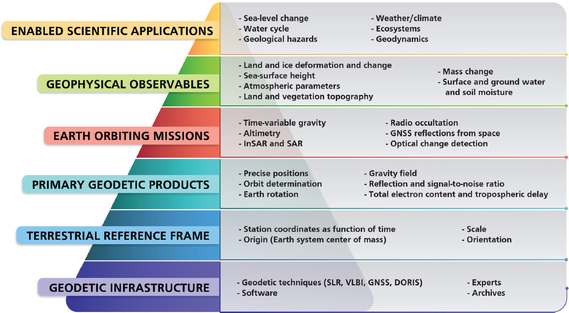
The connections between the geodetic infrastructure and science applications are illustrated in Figure 1.1 and Box 1.1. The geodetic infrastructure (level 1 of Figure 1.1) comprises four measurement techniques used to accurately determine positions of reference points on the Earth, the Earth’s orientation in space, its gravitational field, and the trajectories of satellites in orbit around the Earth. Data from these reference points are used to define the terrestrial reference frame (level 2). Other geodetic data products (level 3) are needed to generate and interpret high-precision data from Earth-orbiting missions (level 4). These missions provide the connection between the terrestrial reference frame and the geophysical observables (level 5), which, in turn, are needed to answer science questions (level 6).
The existing geodetic infrastructure can support many of the science questions discussed in NASEM (2018), as long as it is maintained. However, enhancements to the geodetic infrastructure are required to support other Decadal Survey science questions, such as those connected with sea-level change. For example, Morel and Willis (2005) showed that changing the position of the center of mass of the Earth results in a commensurate change in sea level (see Figure 1.2). The Decadal Survey calls for the accuracy of regional sea-level rise to be better than 0.5 mm/yr decade, which requires a highly accurate and stable terrestrial reference frame. Enhancements to the geodetic infrastructure are also needed to analyze high-precision data from a variety of satellite sensors. Understanding what improvements to the geodetic infrastructure and terrestrial reference frame are needed is a matter of some urgency because high-precision data needed for Decadal Survey science questions are already flowing from satellites in orbit (e.g., Gravity Recovery and Climate Experiment Follow-On [GRACE-FO] and Ice, Cloud and land Elevation Satellite 2 [ICESat-2]). Improving the geodetic infrastructure would also facilitate new discoveries in earth sciences.
COMMITTEE’S TASKS AND APPROACH
At the request of NASA managers, the National Academies of Sciences, Engineering, and Medicine established a committee to identify key connections between geodesy and priority earth science questions, and to explore how to improve the geodetic infrastructure to meet new science needs. The committee tasks are given in Box 1.2.
This report builds on two previous National Academies reports. Precise Geodetic Infrastructure: National Requirements for a Shared Resource (NRC, 2010)
assessed the benefits of the geodetic infrastructure and recommended improvements to meet user demands for increasingly greater precision. To address Task 1, the committee invited U.S. federal agency managers responsible for the geodetic infrastructure to present their assessment of progress made in implementing the NRC (2010) recommendations and their aspirations for the future. The committee used material from the agency presentations, subsequent discussions with other experts, and its own expertise to address the task.
The second foundation report was Thriving on Our Changing Planet: A Decadal Strategy for Earth Observation from Space (NASEM, 2018), which listed the science questions to be considered in this study. To address Task 2, the committee combed through the science questions in NASEM (2018) and selected the ones that depend either on maintaining the current geodetic infrastructure or improving its capabilities.
Those science questions were discussed at a 2-day workshop in February 2019 that brought together those who maintain and improve the geodetic infrastructure with scientists from multiple disciplines seeking to answer questions that require an accurate terrestrial reference frame. The workshop had two goals. The first goal was to identify what specific aspects of the geodetic infrastructure need to be maintained or improved to help answer the science questions being considered (Task 3). Workshop participants considered future needs for ground networks, data processing, on orbit requirements, space-based approaches, and tools, such as simulation capabilities to quantitatively assess the impact of reference frame improvements. The second goal was mutual education: the scientists would better understand how their research connects with the underlying terrestrial reference frame, and NASA and other federal agencies would better understand how terrestrial reference frame realizations need to evolve to answer priority science questions.
The results from the first meeting (Task 1) and the workshop (Tasks 2 and 3) were used to identify priority improvements to the geodetic infrastructure that would facilitate advances across the science questions (Task 4).
GEODETIC INFRASTRUCTURE AND TERRESTRIAL REFERENCE FRAME
Terrestrial Reference Frame
A terrestrial reference system is a spatial reference system attached to the rotating Earth, and it includes the specification of its origin (usually at the center of mass of the Earth), its principal directions (connected with the equator or rotation axes and prime meridian), and a length scale. A terrestrial reference frame is the realization of the terrestrial reference system through a set of coordinates and velocities of stable reference points on the surface of the Earth whose positions are very accurately known as a function of time.1 Such reference points are the locations of GNSS, SLR, Very Long Baseline Interferometry (VLBI), and Doppler Orbitography and Radiopositioning Integrated by Satellite (DORIS) tracking stations. Use of satellite tracking data from these locations results in satellite orbit positions that are expressed in that particular realization of the terrestrial reference frame.
Adoption and use of common terrestrial reference systems and frames allow diverse geodetic measurements to be linked over space and time (see Figure 1.3). The reference points used to realize the terrestrial reference frame are selected so that they have steady and predictable motions on the Earth’s surface at time scales ranging from months to decades. Consequently, the frame itself evolves slowly and predictably and thus can be used for several years without a major update.
The quality of positioning within the terrestrial reference frame is described in terms of precision, accuracy, stability, and drift (NRC, 2010; see Box 1.3). The accuracy of the terrestrial reference frame can be specified—by quantifying uncertainty or by comparing two reference frame realizations—using seven parameters and their time variations. These parameters are the origin (three translations), the orientation (three rotation angles), and the scale (scalar). The science requirements on the accuracy or stability of several of these reference frame parameters drive the future geodetic infrastructure needs.
An international terrestrial reference system has been adopted by the International Earth Rotation and Reference System Service (IERS). The IERS, in collaboration with multi-technique services of the International Association for Geodesy, is also responsible for obtaining ITRF realizations. The ITRF realizations are updated as new data are added and as new technologies or new analysis methods are incorporated. The latest such realization is the ITRF2014 (Altamimi et al., 2016), and preparations have begun for the ITRF2020. Although other global reference systems exist (e.g., WGS84), the ITRF is regarded as having the greatest quality and is the most widely disseminated. The international earth science community, including NASA space-mission data providers and data users, have long used the ITRF for consistent earth science data analyses and interpretation. Consequently, in this report, the ITRF is used as the reference frame realization relevant to the Decadal Survey science objectives, and the phrase “terrestrial reference frame” refers to the ITRF.
___________________
1 Presentation by Frank Lemoine, NASA, at the February 2019 workshop.
Geodetic Infrastructure
The geodetic infrastructure includes the physical infrastructure (e.g., measurement systems and facilities) that allows continuous collection of data at the reference points that define the terrestrial reference frame, as well as geodetic services that play a role in the measurement systems or provide enabling data sets or models. Four complementary measurement techniques are used to define the time-dependent ITRF (see Figure 1.4), and their primary contributions include the following:
- VLBI, which provides information on the three Earth orientation angles and scale.
- SLR, which provides information on the location of the center of mass of the Earth and scale.
- A network of GNSS stations, which enables densification of the reference frame, and provides supplementary information on all seven parameters of the terrestrial reference frame. The density of this network, compared with the relatively small number of VLBI and SLR sites, allows tens of thousands of GNSS receivers on spacecraft, aircraft, ships, and buoys and in local geodetic networks to access or connect to the ITRF (including in real-time). The GNSS network also makes a vital contribution to the measurement of polar motion.
- DORIS, which is a ground-based beacon system mainly used for computing accurate orbits of altimetric spacecraft and for enhancing the global distribution of ITRF positions and velocities.
Each of these four measurement techniques makes several contributions to the terrestrial reference frame (see Table 1.1). These measurement techniques also underpin determination of satellite orbits and Earth orientation parameters.
Very Long Baseline Interferometry
The VLBI system comprises 47 radio telescopes that contribute to the measurements of the Earth’s orientation and scale (Nothnagel et al., 2017; see
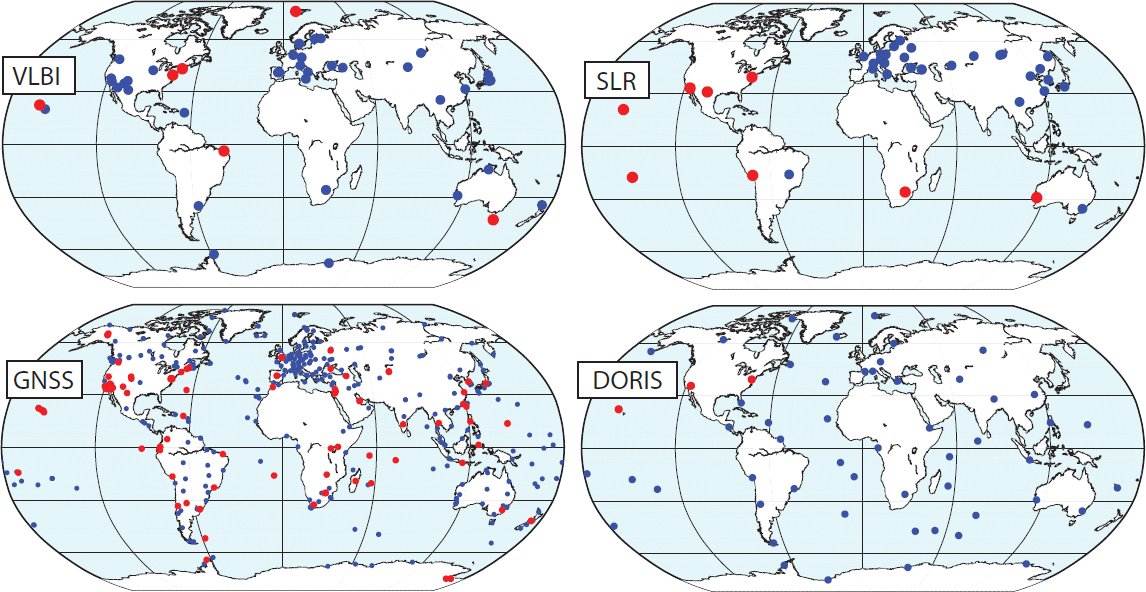
TABLE 1.1 Relative Contributions of Geodetic Measurement Techniques to the Terrestrial Reference Frame
| Technique | VLBI | SLR | GPS | DORIS |
|---|---|---|---|---|
| Signal Target | Microwave quasars | Optical satellites | Microwave satellites | Microwave satellites |
| Observation type | Time difference | 2-way range | Δ Range | Doppler |
| Celestial Frame (UT1) | Strong | Weak | Weak | Weak |
| Scale | Strong | Strong | Medium | Medium |
| Geocenter | Weak | Strong | Medium | Medium |
| Geographic Density | Weak | Weak | Strong | Medium |
SOURCES: Don Argus, Jet Propulsion Laboratory, based on Altamimi et al., 2016, and Haines et al., 2015.
Figure 1.4). With this system, coordinated operation of two or more telescopes allows simultaneous recording of signals from the same extragalactic radio sources. The signal recordings are then pairwise cross-correlated between the telescopes to establish their changing positions with respect to the “fixed” celestial reference frame, as defined by the extragalactic radio sources. Ideally a large number of globally well-distributed VLBI stations should consistently participate in tracking sessions. Systematic errors in VLBI data and data products that can affect the stability of the terrestrial reference frame include the effects of gravitational deformation of VLBI antenna and tropospheric refraction errors.
VLBI is inherently a collaborative global activity, and the master schedule of observations is coordinated by the International VLBI Service for Geodesy and Astrometry (IVS; 41 institutions in 21 countries). This schedule is based on the availability of each station as well as the need for global and temporally dense sampling to measure daily changes in the rotation and orientation of the Earth. All VLBI observations are shared, and several centers of the IERS routinely produce Earth orientation parameters, such as the difference between Universal Time, which is defined by the Earth’s rotation, and Coordinated Universal Time, which is defined by a network of precision atomic clocks. Predictions of this time difference are needed for many applications, such as satellite tracking and military operations.
NASA operates and maintains seven large radio telescopes at six sites around the Earth and is thus a major contributor to the ITRF. Moreover, NASA Goddard Space Flight Center currently hosts the IVS, which coordinates global operations up to 1 year in advance (Nothnagel et al., 2017). The NASA sites have been in operation since the 1980s and work is in progress to install the next-generation VLBI system (see Chapter 2).
Satellite Laser Ranging
The SLR system comprises 39 ground stations distributed around the Earth as well as 11 dedicated geodetic satellites (Pearlman et al., 2002, 2019; see Figure 1.4). The ground stations use short-pulse lasers, optical receivers, and accurate timing to measure the two-way travel time (and hence distance) to retroreflector arrays on the geodetic satellites. The geodetic satellites are mostly in high-altitude orbits where atmospheric drag and other nonconservative forces are minimal, ensuring a long lifetime in orbit. The SLR tracking data is sensitive both to the position of the center of mass of the Earth and to the large spatial scale variations in the gravity field. Such information is critical to the maintenance of the terrestrial reference frame. The biases in timing, range biases in tracking systems, and uncertainty in the knowledge of center of mass of the satellites carrying the retroreflectors can affect the quality of estimation of the reference frame parameters from SLR.
While several scientific satellite missions (e.g., ICESat-2, GRACE-FO, Jason-3, and NASA-ISRO Synthetic Aperture Radar) that support the Decadal Survey (NASEM, 2018) science questions normally use GNSS receivers for precise measurements of the orbital position, SLR provides independent validation of the centering and stability of the orbits for satellites orbits. SLR tracking also serves an important role as a backup tracking system in case of GNSS failure on Earth observation missions, and for determination of long-wavelength gravity field variations. As a result, the SLR ground stations routinely track more than 90 satellites, including much of the GNSS constellations, and thus
provide an important link between the ITRF and satellite positions.
NASA currently operates 8 of the 39 global SLR stations. SLR operations, schedules, and products are coordinated by the International Laser Ranging Service (ILRS), which is currently located at NASA Goddard Space Flight Center. Weekly station coordinate solutions are developed at six ILRS analysis centers and combined as input to the ITRF.
Global Navigation Satellite System
The International GNSS Service (IGS) network comprises 496 globally distributed stations operated by a federation of more than 200 self-funded agencies, universities, and research institutions in more than 100 countries (see Figure 1.4). NASA’s Jet Propulsion Laboratory operates 51 of the IGS stations and hosts the IGS Central Bureau. The IGS organizes the global GNSS network used to compute accurate GNSS orbits and clocks. Station coordinates from this network are an important contributor to the ITRF. The IGS orbits are available in real-time, rapidly (17-hour latency) and in post-analysis (13 days) time frames for GNSS orbits and Earth orientation parameters (polar motion). These frame products are used by continuously operating GNSS receivers (currently more than 10,000 receivers of geodetic quality) around the world, as well as by surveyors, aircraft, and NASA satellites. The IGS also provides other products, such as troposphere delays and maps of the variations in the Earth’s ionosphere. All IGS products are provided without restriction.
In the committee’s view, the GNSS infrastructure is not limited to the IGS stations, but also includes GNSS stations that have long duration and stability and are needed to meet the science objectives of this report.
Doppler Orbitography and Radiopositioning Integrated by Satellite
The DORIS system comprises approximately 55 autonomous and globally distributed stations that have been managed and deployed by the Centre National d’Etudes Spatiales and the Institut Géographique National since 1986 (Moreaux et al., 2016; see Figure 1.4). The third generation of antennae (“Starec C”) is now being deployed. DORIS receivers are used primarily on altimeter satellites (Topography Experiment, Jason 1–3, Environmental Satellite, Cryosat-2, Sentinel-3A/B, and HY-2A) to provide real-time positions with ~30 mm radial orbit accuracy. Co-location of DORIS beacons with other satellite tracking techniques and cohosting other tracking instruments with DORIS onboard these altimetric satellites allows the altimetric sea-level measurements to be interpreted in the ITRF with confidence. Systematic errors in the solar radiation pressure modeling on spacecraft can affect the estimation of parameters of the ITRF.
The International DORIS Service (IDS) provides data and products to geodetic, geophysical, and other research and operational groups. Seven analysis centers contribute their time-dependent station positions and tracking data for the development of the ITRF.
Geodetic Services
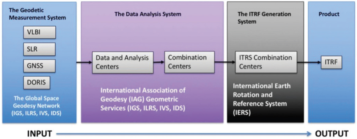
Generation of the ITRF starts by distributing the raw data from the geodetic measurement systems discussed above to the analysis and combination centers (IVS, ILRS, IGS, and IDS), where it is analyzed and refined using computer models and statistical analyses (see Figure 1.5). These higher-level products are then distributed to the IERS to develop the ITRF. No single country or agency is responsible for generating these products. Instead, all parties involved work in an open international collaborative environment to provide the most accurate reference frame for science and applications. Several U.S. agencies, described in Chapter 2, contribute to and benefit from this global activity.
The geodetic services also play an important role in meeting the Decadal Survey (NASEM, 2018) science questions. All NASA missions that rely on accurate orbits for data collection and interpretation depend on the services providing GNSS satellite ephemerides and Earth orientation parameters (at various latencies) as key enabling or ancillary data sets. The services also test, establish, and disseminate the data processing models and standards to the community, which promotes harmonization across diverse space missions.
ORGANIZATION OF THIS REPORT
This report discusses the geodetic infrastructure needed to meet new science needs. Chapter 2
summarizes agency progress in maintaining and improving the geodetic infrastructure since 2010, as well as aspirations for future improvements (Task 1). Chapters 3–7 discuss five categories of science questions (sea-level change, terrestrial water cycle, geological hazards, weather and climate, and ecosystems), the associated measurements that rely on an accurate terrestrial reference frame, and their geodetic needs (Tasks 2 and 3). Detailed connections between the scientific and geodetic needs are presented in Science and Applications Traceability matrixes in Appendix A. Chapter 8 sets priorities for improving the geodetic infrastructure to facilitate answers to the science questions (Task 4) and presents conclusions on all four tasks. The report ends with a list of meeting and workshop participants (see Appendix B), biographical sketches of committee members (see Appendix C), and acronyms and abbreviations used in this report (see Appendix D).
REFERENCES
Adhikari, S., E.R. Ivins, and E. Larour. 2015. ISSM-SESAW v1.0: Mesh-based computation of gravitationally consistent sea level and geodetic signatures caused by cryosphere and climate driven mass change (Data set). https://doi.org/10.5194/gmdd-8-9769-2015.
Altamimi, Z., P. Rebischung, L. Métivier, and X. Collilieux. 2016. ITRF2014: A new release of the International Terrestrial Reference Frame modeling nonlinear station motions. Journal of Geophysical Research: Solid Earth 121(8):6109-6131.
Haines, B.J., Y.E. Bar-Sever, W.I. Bertiger, S.D. Desai, N. Harvey, A.E. Sibois, and J.P. Weiss. 2015. Realizing a terrestrial reference frame using the Global Positioning System. Journal of Geophysical Research: Solid Earth 120(8):5911-5939.
Moreaux, G., F.G. Lemoine, H. Capdeville, S. Kuzin, M. Otten, P. Štěpánek, P. Willis, and P. Ferrage. 2016. The International DORIS Service contribution to the 2014 realization of the International Terrestrial Reference Frame. Advances in Space Research 58(12):2479-2504.
Morel, L., and P. Willis. 2005. Terrestrial reference frame effects on global sea level rise determination from TOPEX/Poseidon altimetric data. Advances in Space Research 36(3):358-368.
NASEM (National Academies of Sciences, Engineering, and Medicine). 2018. Thriving on Our Changing Planet: A Decadal Strategy for Earth Observation from Space. Washington, DC: The National Academies Press.
Nothnagel, A., T. Artz, D. Behrend, and Z. Malkin. 2017. International VLBI service for Geodesy and Astrometry. Journal of Geodesy 91(7):711-721.
NRC (National Research Council). 2010. Precise Geodetic Infrastructure: National Requirements for a Shared Resource. Washington, DC: The National Academies Press.
Pearlman, M.R., J.J. Degnan, and J.M. Bosworth. 2002. The international laser ranging service. Advances in Space Research 30(2):135-143.
Pearlman, M., D. Arnold, M. Davis, F. Barlier, R. Biancale, V. Vasiliev, I. Ciufolini, A. Paolozzi, E.C. Pavlis, K. Sos´nica, and M. Bloβfeld. 2019. Laser geodetic satellites: A high-accuracy scientific tool. Journal of Geodesy 93(11):1-14.
Tapley, B.D., G.H. Born, and M.E. Parke. 1982. The SEASAT altimeter data and its accuracy assessment. Journal of Geophysical Research 87(C5):3179-3188.


