
6
Weather and Climate
The atmosphere is a complex thermodynamic system that varies across length scales ranging from meters to the circumference of the Earth and time scales ranging from minutes and weeks (weather) to years and longer (climate). Understanding and predicting weather and climate requires high spatial and temporal sampling using a wide variety of terrestrial and space-based sensors, combined with complex numerical modeling systems that can properly assimilate these data. The Decadal Survey (NASEM, 2018) includes a range of science questions aimed at advancing our understanding of weather and climate, both in terms of natural processes and anthropogenic forcing. Among the science questions supported by observations that rely on maintenance or enhancement of the geodetic infrastructure are:
W-2. How can environmental predictions of weather and air quality be extended to seamlessly forecast Earth system conditions at lead times of 1 week to 2 months?
C-2. How can we reduce the uncertainty in the amount of future warming of the Earth as a function of fossil fuel emissions, improve our ability to predict local and regional climate response to natural and anthropogenic forcings, and reduce the uncertainty in global climate sensitivity that drives uncertainty in future economic impacts and mitigation/adaptation strategies?
The geodetic infrastructure needs associated with these questions are summarized in the Weather and Climate Science and Applications Traceability Matrix (see Appendix A, Table A.4).
GNSS FOR ATMOSPHERIC REMOTE SENSING
Atmospheric effects have long been an important error source in geodetic measurements. In particular, mismodeled atmospheric delay is a significant contributor to the overall error budget of geodetic measurement techniques. The current positioning precision achieved by the Global Positioning System (and now the Global Navigation Satellite System [GNSS]) is possible only because of the development of advanced models to remove tropospheric effects on GNSS signals. On the other hand, the atmospheric effects on GNSS signals can be used to provide critical data to the atmospheric community (Bevis et al., 1992; Anthes et al., 2011; Ho et al., 2019). The linkage between geodesy and the atmosphere is through refractivity. The index of refraction is a function of pressure, temperature, and water vapor pressure. Refractivity creates delays in the GNSS observations along the path of the signal from the transmitting satellite to the receiving system.
Ground-based GNSS receivers have been used since the 1990s beginning with the Global Positioning System Meteorology (GPS-Met) proof of concept mission (Rocken et al., 1997). These measurements, now made at thousands of sites, are considered an important component of the Global Observing System, and their value to operational numerical weather prediction at the short and medium range is well established. These integrated water vapor products can be used to monitor climate (Wang and Zhang, 2009; Ning and Elgered, 2012), to understand atmospheric circulation features such as the
North American monsoon (Serra et al., 2016), and to improve numerical weather prediction (e.g., Vedel et al., 2004; Bennitt and Jupp, 2012). Ground-based integrated water vapor is also used to calibrate satellite-derived water vapor retrievals (Chen et al., 2008; Mears et al., 2015).
When GNSS receivers are deployed on a low-Earth orbiting satellite with an antenna pointed at the Earth’s limb, GNSS signals are measurably delayed and bent by the Earth’s atmosphere as the satellite either rises or sets behind the Earth with respect to a transmitting GNSS satellite.These signals can be used to retrieve atmospheric refractivity in the sounding region (see Box 6.1). GNSS radio occultation (GNSS-RO) systems depend critically on the International GNSS Service (IGS) geodetic infrastructure to specify the GNSS orbits and clocks.1
GNSS-RO measurements have been used to study large-scale atmospheric dynamics, such as the El Niño Southern Oscillation and sudden stratospheric warming, and to understand atmospheric gravity waves so they can be parameterized in global climate models (Alexander et al., 2008). Because GNSS-RO measurements are traceable to the International System of Units, they do not require bias correction (Ho et al., 2010, 2019). In this regard, they can be used as “anchor” measurements for microwave and infrared observations (Aparicio and Laroche, 2015) and improve bias corrections applied to satellite radiance measurements (Auligné et al., 2007). When GNSS-RO data are assimilated into global weather reanalyses systems, this anchoring ability has been demonstrated to provide a continuous record of upper air temperature since 2006 (Dee et al., 2011). This long-term accuracy is due to the timing stability of GNSS, which itself is based on the timing stability of the geodetic infrastructure.
The importance of GNSS-RO for climate monitoring and climate model testing is still an emerging field, primarily because of the relatively short length of the GNSS-RO time series. Nevertheless, the Intergovernmental Panel on Climate Change (IPCC) intends to include GNSS-RO results in its Sixth Assessment Report, and recent work has shown how GNSS-RO improves the consistency of climate reanalyses in the stratosphere (e.g., Ho et al., 2019).
IMPROVEMENTS IN WEATHER MODELS
Question W-2 touches on the societal need to extend the accuracy of numerical weather prediction forecasts for 2 months. Accurate and detailed specification of the environmental state and analysis is a key precondition for any forecast. GNSS-RO offers the ability to sound the atmosphere over land and water in all weather conditions, and to provide observations with high vertical resolution, making it an essential component of the Global Observing System. The direct assimilation of GNSS-RO observations into the analysis fields improves the initial conditions used for forecasting. Multiple studies have demonstrated the value of GNSS-RO to improve analysis fields for numerical weather prediction (Healy, 2008, 2013; Aparicicio and Deblonde, 2009; Cucurull, 2010; Nie et al., 2019). This improvement is evident even though the number of GNSS radio occultations is low compared with the number of satellite radiances that are assimilated (e.g., Healy and Thepaut, 2006; Aparicio and Deblonde, 2008; Poli et al., 2008; Cucurull, 2010; Rennie, 2010). The impact of this relatively small amount of data has led the International Radio Occultation Working Group to recommend establishment of an observing system that provides a minimum of 20,000 occultations per day for numerical weather prediction and other applications.2 One application of RO with significant society benefit is predicting heavy precipitation events associated with atmospheric rivers (see Box 6.2).
Using GNSS-RO data within a model verification system is an additional way to extend the accuracy of numerical weather prediction forecasts. Understanding how errors in numerical weather prediction systems grow over time is a key aspect of extending forecast accuracy. High-quality observations of the atmosphere are critical for this task. Using GNSS-RO data as a diagnostic tool to identify errors in numerical weather prediction systems will have a significant impact in improving model forecasting skill.
___________________
1 The International Radio Occultation Working Group—a permanent Working Group of the Coordination Group for Meteorological Satellites (CGMS)—recommends that CGMS works with responsible entities, including IGS, to assure that GNSS ground station infrastructure is sufficiently supported so that they can provide the necessary orbit and geodetic data.
2 See http://www.wmo.int/pages/prog/sat/meetings/documents/IPET-SUP-3_INF_02-01_IROWG5-Minutes-Summary-Feb162017VApr2017.pdf.
Measurements
The basic geometry of the RO measurement is described in Box 6.1. Once the ray path reaches the top of the atmosphere any error in the clocks or positions of the satellites maps directly into an error in the total path delay, which becomes an error in the retrieval of the vertical profiles of temperature, water vapor pressure, and, to a lesser extent, the total electron content of the ionosphere (Kuo et al., 2004). Determining clock error estimates at intervals of 1 second enables single differencing to remove receiver errors, resulting in a significant reduction in random noise. This is particularly important for refractivity retrievals above 30 km (Schreiner et al., 2010).
Geodetic Needs
As discussed in the section “GNSS For Atmospheric Sounding,” a significant advantage of GNSS-RO with respect to other satellite and ground based measurements is that it is not necessary to cross-calibrate sensors over time because GNSS-RO depends on accurate measurements of travel time and satellite orbits. Therefore, RO is critically dependent on the geodetic infrastructure through its ability to provide precise and accurate GNSS satellite orbits and clocks. These geodetic products are used to estimate the low-Earth orbit satellite orbit and clocks, and to remove the geometric portion of delay from the RO signals. Maintaining the climate record also depends on the maintenance and long-term stability of the terrestrial reference frame (TRF) and enhancements in the GNSS satellite and processing systems. Other needs include
- Upgrading the global IGS sites (hardware and products) to achieve GPS-like accuracies in the other constellations (e.g., Galileo, Glonass, and Beidou; Steigenberger et al., 2015). This upgrade is important because it would result in an increase in the number of GNSS satellites used for making occultation measurements.
- Improve the modeling of non-GPS GNSS observables within geodetic analysis systems, including transmitter attitude information, satellite metadata, and radiation force models.
- Improving GNSS clock accuracies over the 0.5–30 sec time span to improve temperature and water vapor profiles (Schreiner et al., 2010).
- Increasing GNSS sampling rate to 2 Hz from the standard 1 Hz at IGS sites to minimize clock interpolation errors.
- Encouraging multi-GNSS (e.g., GPS, Galileo, Glonass, and Beidou) analysis of orbits and clocks by U.S. groups.
- Improving global GNSS coverage by adding ~10 GNSS sites on remote islands, ocean mooring sites, and ice sheets. These additional sites will improve estimates of integrated water vapor, especially at high latitudes.
- Collocating the Global Climate Observing System Reference Upper-Air Network (GRUAN) and space geodetic infrastructure sites (GNSS, Very Long Baseline Interferometry, Satellite Laser Ranging) for mutual calibration and validation.
REDUCING UNCERTAINTY IN CLIMATE PROJECTIONS
Question C-2 concerns reducing uncertainty in projections of global warming to better understand future economic impacts and to devise appropriate adaptation and mitigation strategies. Surface air temperature is not a robust measurement for monitoring global warming because the spatial pattern of temperature variations is highly variable and is not well resolved by the current distribution of ground stations (Leroy et al., 2006). Because of its high accuracy, lack of observational drift, and bias-free nature (Anthes et al., 2011), GNSS-RO has been colloquially termed the most accurate thermometer in space. GNSS-RO can provide critical measurements of atmospheric temperature and pressure in the 5–20 km altitude range where there are less spatial and temporal variations to obscure the longer-term climate signal (NASEM, 2018). In the lower troposphere, GNSS-RO can be used to retrieve atmospheric water vapor profiles, including boundary layer water vapor, providing essential water vapor information throughout the globe. It is also complementary to other satellite sensors, such as infrared and microwave sensors.
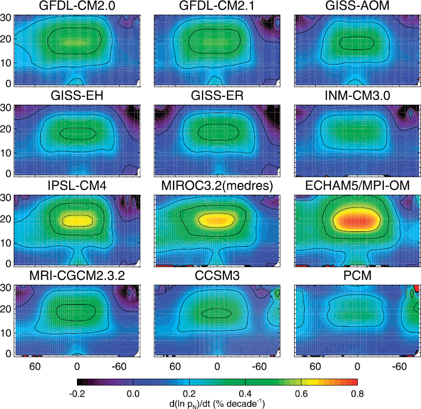
Figure 6.6 illustrates the sensitivity of the change in atmospheric pressure versus time for each of the 12 climate models used in the IPCC Fourth Assessment. The models are all similar in the troposphere (<10 km) but are very different at the 20 km altitude range where GNSS-RO has its highest sensitivity. Leroy et al. (2006) showed that GPS-RO measurements could discriminate among the 12 models at 95 percent confidence in 7 to 13 years. They also found that the strongest indicator of atmospheric climate change in the data is the poleward migration of the midlatitude jet. The ability to use GNSS-RO to assess the accuracy of climate models and to track changes in features such as the midlatitude jet are just two examples of the contribution of GNSS-RO for monitoring climate change.
Measurements
Same as for “Improvements in Weather Models.”
Geodetic Needs
Same as for “Improvements in Weather Models.”
SUMMARY
A robust and resilient geodetic infrastructure has underpinned the rapid GNSS-RO progress in both numerical weather prediction and climate applications since the 1990s. It is essential that this infrastructure is maintained and developed, in order to continue to exploit this observation type and take advantage of new opportunities, such as the availability of more GNSS systems. GNSS-RO measurements rely on accurate clocks and orbits of the GNSS constellations, which in turn rely on the geodetic infrastructure. The sheer number of RO per day requires a fully automated system with frequent updates of clocks and orbital information. Maintaining absolute accuracy over perhaps hundreds of years will require a stable TRF, precise orbits for the GNSS satellites as well as the low-Earth orbiting satellites, and a consistent approach to antenna models and data processing. In addition, a workforce with the appropriate technical capacity and institutional knowledge needs to be trained and maintained. The following summarizes needs for maintaining or enhancing the geodetic infrastructure, and related improvements to enhance scientific returns.
Maintenance of the Geodetic Infrastructure
- Maintain robust global distribution of GNSS stations providing free, open, and near-real-time raw observational data.
- Continued support of IGS analysis products, including accurate orbits and clocks.
- Maintain geodetic expertise for institutional knowledge and availability of trained personnel. This will require stable and predictable funding.
Enhancements to the Geodetic Infrastructure
- Upgrade the global IGS sites (at least the National Aeronautics and Space Administration sites) to achieve GPS-like accuracies for the other constellations (e.g., Galileo, Glonass, and Beidou). In addition, improve the modeling of GNSS observables within geodetic analysis systems, including attitude information, satellite metadata and radiation force models. A significant upgrade would result in an increase in the number of radio occultations for weather and climate applications.
Related Improvements to the Geodetic Infrastructure to Enhance Scientific Returns
- Improve the GNSS instrumentation on the low-Earth orbiting satellites and IGS sites to include Navigation Data Message data collection (for RO open-loop processing).
- Deploy surface meteorology (pressure/temperature) sensors at core sites.
- Provide an integrity check for near-real-time clocks.
- Improve GNSS clock estimation from 0.5–30 sec time scales.
- Co-locate some IGS core sites with the GRUAN sites for mutual calibration and validation.
- Install GNSS on ocean platforms (~10) to calibrate satellite observations of integrated water vapor as well as to support studies of air-sea fluxes.
- Use the global GNSS constellation and low-Earth orbiting satellites to improve ionospheric models.
- Use ionosphere models developed by the space weather community to develop geodetic products. These products could be better than IGS Global Ionospheric Total Electron Content Map products and thus could be used for ionospheric corrections to single frequency Interferometric Synthetic Aperture Radar measurements.
REFERENCES
Alexander, S.P., T. Tsuda, Y. Kawatani, and M. Takahashi. 2008. Global distribution of atmospheric waves in the equatorial upper troposphere and lower stratosphere: COSMIC observations of wave mean flow interactions. Journal of Geophysical Research: Atmospheres 113(D24):D24115.
Anthes, R.A. 2011. Exploring Earth’s atmosphere with radio occultation: Contributions to weather, climate and space weather. Atmospheric Measurement Techniques 4:1077-1103.
Anthes, R.A., P.A. Bernhardt, Y. Chen, L. Cucurull, K.F. Dymond, D. Ector, S.B. Healy, S.-P. Ho, D.C. Hunt, Y.-H. Kuo, H. Liu, K. Manning, C. McCormick, T.K. Meehan, W.J. Randel, C. Rocken, W.S. Schreiner, S.V. Sokolovskiy, S. Syndergaard, D.C. Thompson, K.E. Trenberth, T.-K. Wee, N.L. Yen, and Z. Zeng. 2008. The COSMIC/FORMOSAT-3 mission: Early results. Bulletin of the American Meteorological Society 89(3):313-334.
Aparicio, J.M., and G. Deblonde. 2008. Impact of the assimilation of CHAMP refractivity profiles on Environment Canada global forecasts. Monthly Weather Review 136(1):257-275.
Aparicio, J., and S. Laroche. 2015. Estimation of the added value of the absolute calibration of GPS radio occultation data for numerical weather prediction. Monthly Weather Review 143:1259-1274.
Auligné, T., A.P. McNally, and D.P. Dee. 2007. Adaptive bias correction for satellite data in a numerical weather prediction system. Quarterly Journal of the Royal Meteorological Society 133(624):631-642.
Bennitt, G.V., and A. Jupp. 2012. Operational assimilation of GPS zenith total delay observations into the Met Office Numerical Weather Prediction models. Monthly Weather Review 140:2706-2719.
Bevis, M., S. Businger, T.A. Herring, C. Rocken, R.A. Anthes, and R.H. Ware. 1992. GPS meteorology: Remote sensing of atmospheric water vapor using the Global Positioning System. Journal of Geophysical Research: Atmospheres 97(D14): 15787-15801.
Bonafoni, S., R. Biondi, H. Brenot, and R. Anthes. 2019. Radio occultation and ground-based GNSS products for observing, understanding and predicting extreme events: A review. Atmospheric Research 230:1-18.
Chen, S.H., Z. Zhao, J.S. Haase, A. Chen, and F. Vandenberghe. 2008. A study of the characteristics and assimilation of retrieved MODIS total precipitable water data in severe weather simulations. Monthly Weather Review 136(9):3608-3628.
Cucurull, L. 2010. Improvement in the use of an operational constellation of GPS Radio Occultation receivers in weather forecasting. Weather Forecasting 25:749-767.
Dee, D.P., S.M. Uppala, A.J. Simmons, P. Berrisford, P. Poli, S. Kobayashi, U. Andrae, M.A. Balmaseda, G. Balsamo, P. Bauer, P. Bechtold, A.C.M. Beljaars, L. van de Berg, J. Bidlot, N. Bormann, C. Delsol, R. Dragani, M. Fuentes, A.J. Geer, L. Haimberger, S.B. Healy, H. Hersbach, E.V. Hólm, L. Isaksen, P. Kållberg, M. Köhler, M. Matricardi, A.P. McNally, B.M. Monge-Sanz, J.-J. Morcrette, B.-K. Park, C. Peubey, P. de Rosnay, C. Tavolato, J.-N. Thépaut, and F. Vitart. 2011. The ERA-Interim reanalysis: Configuration and performance of the data assimilation system. Quarterly Journal of the Royal Meteorological Society 137(656):553-597.
Foelsche, U., B. Pirscher, M. Borsche, G. Kirchengast, and J. Wickert. 2009. Assessing the climate monitoring utility of radio occultation data: From CHAMP to FORMOSAT- 3/COSMIC. Terrestrial Atmospheric and Oceanic Science 20:155-170.
Fong, C.J., C.H. Chu, C.L. Lin, and A. da Silva Curiel, 2019.Toward the most accurate thermometer in space: FORMOSAT-7/COSMIC-2 constellation. Aerospace and Electronic Systems Magazine 34(8):12-20.
Healy, S.B. 2008. Forecast impact experiment with a constellation of GPS radio occultation receivers. Atmospheric Science Letters 9:111-118.
Healy, S.B. 2013. Surface pressure information retrieved from GPS radio occultation measurements. Quarterly Journal of the Royal Meteorological Society 139:2108-2118.
Healy, S.B., and J. Thépaut. 2006. Assimilation experiments with CHAMP GPS radio occultation measurements. Quarterly Journal of the Royal Meteorological Society 132:605-623.
Ho, S.-P., Y.-H. Kuo, W. Schreiner, and X. Zho. 2010. Using SI-traceable Global Positioning System radio occultation measurements for climate monitoring. Bulletin of the American Meteorological Society 91(7):S36-S37.
Ho, S.P., R.A. Anthes, C.O. Ao, S. Healy, A. Horanyi, D. Hunt, A.J. Mannucci, N. Pedatella, W.J. Randel, A. Simmons, and A. Steiner. 2019. The COSMIC/FORMOSAT-3 Radio Occultation Mission after 12 years: Accomplishments, remaining challenges, and potential impacts of COSMIC-2. Bulletin of the American Meteorological Society. https://doi.org/10.1175/BAMS-D-18-0290.1.
Kuo, Y-H., T-K. Wee, S. Sokolovskiy, C. Rocken, W. Schreiner, D. Hunt, and R.A. Anthes. 2004. Inversion and error estimation of GPS radio occultation data. Journal of the Meteorological Society of Japan. Ser. II 82(1B):507-531.
Leroy, S.S., J.G. Anderson, and J.A. Dykema. 2006. Testing climate models using GPS radio occultation: A sensitivity analysis. Journal of Geophysical Research: Atmospheres 111:D17105.
Mears, C.A., J. Wang, D. Smith, and F.J. Wentz. 2015. Intercomparison of total precipitable water measurements made by satellite-borne microwave radiometers and ground-based GPS instruments. Journal of Geophysical Research: Atmospheres 120(6):2492-2504.
NASEM (National Academies of Sciences, Engineering, and Medicine). 2018. Thriving on Our Changing Planet: A Decadal Strategy for Earth Observation from Space. Washington, DC: The National Academies Press.
Neiman, P.J., F. Martin Ralph, G.A. Wick, Y.-H. Kuo, T.-K. Wee, Z. Ma, G.H. Taylor, and M.D. Dettinger. 2008. Diagnosis of an intense atmospheric river impacting the Pacific Northwest: Storm summary and offshore vertical structure observed with COSMIC satellite retrievals. Monthly Weather Review 136(11):4398-4420.
Nie, Y., A.A. Scaife, H.L. Ren, R.E. Comer, M.B. Andrews, P. Davis, and N. Martin. 2019. Stratospheric initial conditions provide seasonal predictability of the North Atlantic and Arctic Oscillations. Environmental Research Letters 14(3):034006.
Ning, T., and G. Elgered. 2012. Trends in the atmospheric water vapor content from ground-based GPS: The impact of the elevation cutoff angle. IEEE Journal of Selected Topics in Applied Earth Observations and Remote Sensing 5(3):744-751.
Poli, P., S.B. Healy, F. Rabier, and J. Pailleux. 2008. Preliminary assessment of the scalability of GPS radio occultations impact in numerical weather prediction. Geophysical Research Letters 35(23):L23811.
Rennie, M.P. 2010. The impact of GPS radio occultation assimilation at the Met Office. Quarterly Journal of the Royal Meteorological Society 136(646):116-131.
Rocken, C., R. Anthes, M. Exner, D. Hunt, S. Sokolovskiy, R. Ware, M. Gorbunov, W. Schreiner, D. Feng, B. Herman, and Y.H. Kuo. 1997. Analysis and validation of GPS/MET data in the neutral atmosphere. Journal of Geophysical Research: Atmospheres 102(D25):29849-29866.
Schreiner, W., C. Rocken, S. Sokolovskiy, and D. Hunt. 2010. Quality assessment of COSMIC/FORMOSAT-3 GPS radio occultation data derived from single-and double-difference atmospheric excess phase processing. GPS solutions 14(1):13-22.
Serra, Y.L., D.K. Adams, C. Minjarez-Sosa, J.M. Moker Jr., A.F. Arellano, C.L. Castro, A.I. Quintanar, L. Alatorre, A. Granados, C. E.Vazques, K. Holub, and C. DeMets. 2016. The North American monsoon GPS transect experiment 2013. Bulletin of the American Meteorological Society 97(11):2103-2115.
Steigenberger, P., U. Hugentobler, S. Loyer, F. Perosanz, L. Prange, R. Dach, M. Uhlemann, G. Gendt, and O. Montenbruck. 2015. Galileo orbit and clock quality of the IGS Multi-GNSS Experiment. Advances in Space Research 55(1):269-281.
Steiner, A.K., B.C. Lackner, F. Ladstädter, B. Scherllin-Pirscher, U. Foelsche, and G. Kirchengast. 2011. GPS radio occultation for climate monitoring and change detection. Radio Science 46:RS0D24.
Vedel, H., X.Y. Huang, J. Haase, M. Ge, and E. Calais. 2004. Impact of GPS zenith tropospheric delay data on precipitation forecasts in Mediterranean France and Spain. Geophysical Research Letters 31(2):L02102.
Wang, J., and L. Zhang. 2009. Climate applications of a global, 2-hourly atmospheric precipitable water vapor dataset derived from IGS tropospheric products. Journal of Geodesy 83: 209-217.
Wang, M., J. Wang, Y. Bock, H. Liang, D. Dong, and P. Fang. 2019. Dynamic mapping of the movement of landfalling atmospheric rivers over Southern California with GPS data. Geophysical Research Letters 46:3551-3559.


