
2 Regional Freshwater Budgets Under Major Use Scenarios
KEY TOPICS
To begin the first panel discussion, Dr. Upmanu Lall (Columbia University) noted that the large amount of uncertainty in groundwater analyses and the potential for significant biases in modeling and estimates of water use present key challenges. As an example, he noted that water use is dominated by irrigation, however actual irrigation practices (dictated by agricultural extension services) are not being incorporated in the biophysical equations that provide estimates of water used for this purpose. Thus, researchers may be over- or under-estimating actual irrigation rates and frequency, introducing bias in the calculations.
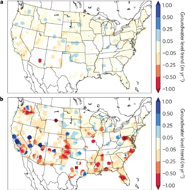
Groundwater cannot be isolated from surface water sources, and even within groundwater sources, the access dynamics for shallow and deep water are very different. Dr. Lall illustrated that most modeling focuses on rates of change in groundwater level from shallow wells, but deep wells are experiencing much greater trends in changing groundwater levels (see Figure 2.1). In terms of sensitivity to climate variability, deep water is typically pumped during times of long, persistent drought. Therefore, deep groundwater also has a much higher sensitivity to climate than shallow groundwater, due to human behavior (i.e., deep water pumping), not the natural system response. Dr. Lall explained that, although the scientific community tends to focus solely on hydrological information, increased ability to integrate interactions between the human (non-hydrologic) and natural parts of the system can help achieve greater understanding of the dynamics and can also help to diagnose risk. In fact, Dr. Lall suggested that the key issue with groundwater is not necessarily about how much is available, but if it is accessible and who is able to access it. This is a social equity and injustice issue because disadvantaged populations typically lack access to water and may be forced to consider options such as migration.
Using the Upper Colorado Basin and the Himalayan Basins as examples, Dr. Harihar Rajaram (Johns Hopkins University) discussed aspects of climate change resilience provided by groundwater in mountain watersheds. In the Upper Colorado Basin, more than half of the streamflow is delivered by a baseflow derived source, even though most of that is lost to evapotranspiration and diversions before it gets to the lower basin (Miller et al., 2016). Baseflow yield is higher at higher elevations, but the fraction of annual total flow represented by baseflow is higher at lower elevations. Thus, there is some measure of resilience because groundwater can be thought of as a store that has some delay in delivering hydrologic input to streams and can
sustain late season flows. On a smaller scale, a study of the Colorado River headwater basin illustrates the role of deep groundwater in hydrologic budgets (Carroll et al., 2019). This is a fairly water-stressed system that has not been adequately explored because climate change projections do not typically consider these deeper groundwater systems. There is some evidence to suggest that reduced recharge will have significant influence on groundwater availability, and may even degrade water quality in mineralized sub-basins (Meixner et al., 2016).
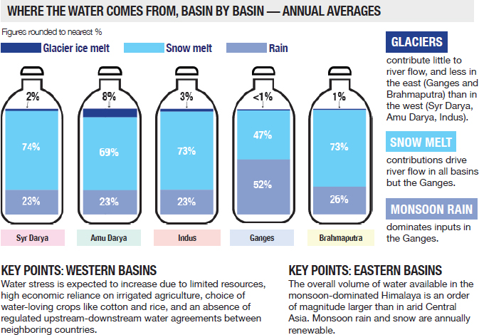
Very little is known about some of the more remote areas of the Himalayan Basins, and Dr. Rajaram mentioned that these are also sensitive areas from a geopolitical perspective. Snow melt and precipitation are major contributors to the water budget (as opposed to glacier melt), and in the Ganges Basin, monsoon rain is a major contributor as well (see Figure 2.2). A combination of the monsoon and rainfall forcing is delivered to the streams via groundwater flow pathways. In most of the year, streamflow exceeds precipitation input which signifies a delay because of the groundwater pathways. Two thirds of the annual discharge in Upper Ganges Basin is delivered via groundwater pathways that implies a delay of about 2 months, indicating some
level of resilience. Climate change projections in the Himalayan Basins indicate an increase in precipitation, which could lead to an increase in streamflow. This could have implications for water availability within deep water systems for military personnel in that area, for example. Dr. Rajaram noted that airborne and remote sensing technologies likely have a role to play in large-scale sub-surface characterization to better constrain properties of mountain aquifer systems.
Dr. Ryan Smith (Missouri University of Science and Technology) discussed land subsidence due to groundwater extraction around the globe, which occurs mostly in confined aquifers under major use scenarios. There can be some subsidence in unconfined1 aquifers as well, but because the amount of subsidence is proportional to the change in water level or head, there is much more subsidence in confined aquifers. He illustrated a high use scenario in the Central Valley of California, which includes approaches and challenges that are common to many other areas around the world. The loss of groundwater storage is, for the most part, a permanent loss and in the areas of greatest subsidence, it is happening at a rate of approximately 25 cm/year. This area contains one percent of the nation’s farm land, and almost all of the water demand comes from agricultural use. Eight percent of the nation’s food is produced here, including high value crops. Thus, these crops need to be irrigated, even in a drought year because of the economic implications. Regional geology and groundwater pumping play significant roles in
___________________
1 A confined aquifer is an aquifer below the land surface that is saturated with water. Layers of impermeable material are both above and below the aquifer, causing it to be under pressure so that when the aquifer is penetrated by a well, the water will rise above the top of the aquifer. A water-table—or unconfined—aquifer is an aquifer whose upper water surface (water table) is at atmospheric pressure, and thus is able to rise and fall.
understanding and quantifying why some areas subside more than others, though most areas have similar water demands and similar decline in head. Dr. Smith outlined an approach to couple InSAR derived estimates of subsidence with airborne electromagnetic (AEM) estimates of groundwater and aquifer properties to build more accurate groundwater models. Using these methods, one can see how thick the clay deposits are, which tend to cause the most compaction. Coupled modeling to estimate aquifer and textural properties enables forecasting of future hydrologic scenarios, and this approach may also be used in other areas with limited groundwater data. AEM data can provide a good sense of the geology and InSAR can serve as a proxy for hydrologic changes.
Two studies (in California and Vietnam) show that deep pumping for clean water is releasing arsenic from clays, where it had been trapped, and releasing it into the groundwater supply (Erban et al., 2013; Smith et al., 2018). Dr. Smith reiterated that release of arsenic is a complex process, but it is something that needs to be considered in major use scenarios, as pumping from confined aquifers could be damaging water quality in addition to depleting storage.
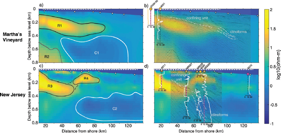
To illustrate emerging technologies that can be transformative in understanding water resources, Dr. Mark Person (New Mexico Institute of Mining and Technology) discussed studies using magnetotelluric (MT) methods and mathematical modeling to reveal new groundwater resources that have yet to be utilized. In the first example, he explored fresh offshore groundwater in the continental shelves. Offshore freshwater is a global phenomenon due to changes in sea level, and there have been efforts to quantify the volume of this resource (Post et al., 2013). Marine MT and models are now being used together with limited well data to discover and map offshore freshwater. Using MT and controlled source electromagnetic (CSEM) systems, formation resistivity can be imaged to indicate areas of freshwater (see Figure 2.3). The huge volumes of offshore freshwater sequestered in continental shelf sands can be a potential resource for coastal megacities in times of drought.
MT can also be used to look at deep crystalline basement groundwater flow systems in the arid Southwest United States. Companies and agribusinesses can use this warm, freshwater for aquaculture and to heat greenhouses. In this second example, Dr. Person discussed permeable crystalline rocks and high heat flow in New Mexico. One study assesses deep groundwater flow in the crystalline basement below Truth or Consequences, New Mexico. The geothermal water comes from deep recharge in the mountainous terrain approximately 68 km away. It is estimated that the geothermal discharge is two million gallons/day, and that is approximately 10 percent of the mountain front recharge that discharges through a hydrologic window where the crystalline basement is exposed at the land surface (Person et al., 2013). Recharge rate in this area is 5-10 cm/year. Through numerical modeling, it is clear that this is a deep flow system, probably with crystalline basement permeabilities that are uncommon. An MT study of the region from the recharge to the discharge area revealed that there are more resistive crystalline basement rocks in the recharge areas at higher elevations. These are quite a bit more permeable and conductive than typical crystalline basement rock. In the discharge area near the hot springs, the geothermal fluids pick up heat and salinity along the flow path and they become more conductive. A deep flow system is needed to produce these thermal anomalies and salinity.
These deep crystalline basement flow systems are economically important to local communities because the water is used for greenhouses and aquaculture. Thus, crystalline basement and volcanic formations could represent viable, sustainable resources for arid communities. Using MT surveys in an EarthScope style campaign to look at deep flow systems and unconventional aquifers could lead to important advances in understanding water resources of the U.S. continent and continental shelf.
DISCUSSION
Thinking beyond remote sensing and satellite technologies, Dr. Kamini Singha asked the panelists if “soft” data are available to provide information on water budgets. Dr. Lall noted that an interesting proxy is sales, by district, of different types and capacities of pumps in India. Farmers report their pump purchases and installations annually, and researchers are able to obtain specifications from the pump manufacturers. He also noted that monitoring the media for any mentions of groundwater quantity or quality and geocoding that information can provide useful data. Establishing and utilizing diverse sources of information is a crucial first step. Dr. Rajaram added that geologic cross sections and maps would be helpful as well, and Dr. Jim Butler noted that one of the most important soft data sources is the distribution of pumping wells in heavily pumped areas.
Dr. Si Gou mentioned ongoing projects to explore overuse of groundwater for irrigation and ways to manage irrigation in agriculture to reduce this overuse. As noted earlier, regional water balance is important for water resource management, but researchers do not have data for how much groundwater is overused. Dr. Smith reiterated that there are tools to estimate groundwater use, but there are also large uncertainties. In researching water demand some information can be estimated by satellite remote sensing or ground-based data, but the challenge is knowing if people are over- or under-irrigating their crops. Knowing soil moisture over the course of the growing season can help provide some information. Dr. Lall mentioned an effort to get pump manufacturers to add a water meter to each pump. If this was mandated by the government, there is a potential to obtain direct data on usage of each pump. Dr. Butler noted that Kansas has all high capacity pumping wells metered and reported, and that this data set could be used to get sense for how people operate in the field.
Dr. James Dobrowolski asked about how fresh the offshore groundwater is, if there is a temporal shift to these volumes, and if the speakers could provide a major use scenario for this continental shelf resources. Dr. Person noted that MT systems image formation resistivity, so it is not known how fresh or brackish the water is. Data from offshore wells indicate that some water treatment may be required to use the water. This is a non-renewable resource, and the water would only be available for a finite period of time. In terms of the possibility of temporal variability, the groundwater is likely tens of thousands or hundreds of thousands years old. In theory, coastal mega cities could use the resources in times of extreme drought, but it will be costly. Given the depth of this resource, Dr. Lall pointed out that it is likely to be prohibitively expensive to pump and potentially desalinate this water compared to the cost of simply desalinating ocean water. Dr. Person pointed out that the cost of desalinating brackish water is much lower than the cost of desalinating ocean water, and it is not typically known what the head conditions are in many of these offshore systems. Utilizing this groundwater may be economically feasible in some areas, but not others.
Following a period of focused breakout group discussions, designated group leaders provided summaries of each team’s work. The participants were asked to identify challenges and opportunities for future research in understanding freshwater budgets. The primary challenge noted by participants was access to in situ data (including, for example, groundwater level, pumping rates, and streamflow) and limitations associated with the data that are available including efforts to quantify uncertainties and bias. Participants specifically highlighted a lack of in situ data in hard to reach locations such as deep aquifer systems and rural areas. Increased spatial and temporal coverage and frequency of data collection could provide crucial information needed to fill in some of these gaps. Remote sensing can also provide the means to address these gaps, but the group leaders emphasized that there are human and societal aspects of the system that remain poorly understood and are difficult to obtain using current technologies. The role of human behavior and decision-making in the water cycle could be better characterized and integrated into the modeling. It will likely be important to clarify the goals and audience of the intended measurements to ensure consistency and transparency in the information underlying the data sets.
Some of the opportunities raised by the participants include exciting new techniques and technologies that can be employed to achieve greater understanding of aquifer systems.
Examples given include advanced sensors to detect water quality and quantity, utilizing the “Internet of Things” to harvest data from unique sources, artificial intelligence, knowledge discovery mechanisms, machine learning, and remote sensing developments such as CubeSats, airborne measurement systems, weather balloons, and unmanned aerial systems (UASs). Many participants also noted the importance of leveraging existing data through increased integration between modeling and science centers that may help capture adaptive feedback from multiple scales and processes. Integration and data fusion represent an opportunity to effectively utilize the data we do have; this includes integration of remote sensing and in situ data as well as integration of human behaviors into the models. Leveraging existing remote sensing data can also provide useful comparisons with models and can help guide requests for water sampling in specific locations where data are needed. Increasingly sophisticated modeling and advances in computing power could also advance researchers’ ability to take a system dynamics perspective. Some participants noted that this may be an opportunity to strengthen international partnerships and invest in infrastructure that could play a role in translating water cycle understanding to local and regional policy-makers and resource management teams.
Participants were also asked about data that would be most useful in determining freshwater budgets and if there are specific types of useful data that researchers currently struggle to collect. Among the variables discussed, several participants highlighted precipitation, water storage, discharge, water quality, soil data, evapotranspiration, rates of recharge, land surface information, maps of well locations, and environmental isotopes as crucial data needs to improve understanding and modeling capabilities. Others raised the issue of unknowns associated with water usage, consumption, transfers, and system losses, all of which are tightly connected to human decision-making, industrial, agricultural, and economic factors. Importantly, several participants noted that the necessary spatial and temporal scales and the required measurements ultimately depend on the local system complexity, the local processes and dynamics, and the questions being asked. The biogeochemistry of the system and how it changes over time are very site specific, and data priorities will therefore depend on the location and the type of scientific research taking place. Again, participants noted that data management and planning will play a crucial role in future research, and increased coordination (possibly through international partnerships) can help with the development of standardized data repositories, standard data formats, and open source code.
Attendees were asked to consider which aspects of freshwater balance might benefit from NGA resources in particular. Indeed, several group members were interested in pursuing partnerships and collaborations with NGA to collect crucial information, to exploit existing resources, to enable new technology development, and to improve model accuracy. Breakout participants expressed a particular interest in working with NGA to obtain observations of variables that are difficult to measure such as river discharge from major rivers, lake and reservoir storage and their changes over time, soil moisture, land use, and aspects of human water usage including drinking water supplies near cities, mining effects on communities, and metered irrigation data. Having additional centralized data storage, common data standards, and protocols for sharing data and metadata was also recognized, as well as the potential for community-enabled cyber infrastructure (e.g., EarthCube2), advanced computational resources,
___________________
and image processing expertise. Stewardship of technologies such as airborne campaigns, UASs, and drone-based instrumentation was suggested as a possible role for NGA and other agencies. Increased access to existing data sets, as well as the context in which the data were collected, could allow researchers to more effectively exploit the information, especially when it is stored in atypical formats (e.g., natural language processing of historical data). Examples already exist in which NGA helps to facilitate increased international and interdisciplinary collaborations including the World-Wide Human Geography Data Working Group3 partnership with the U.S. Department of State. Other partnerships could help advance these efforts even further (see Box 2.1).
___________________
3 See https://www.wwhgd.org.


