
3 Research Frontiers in Characterizing Groundwater Aquifers
KEY TOPICS
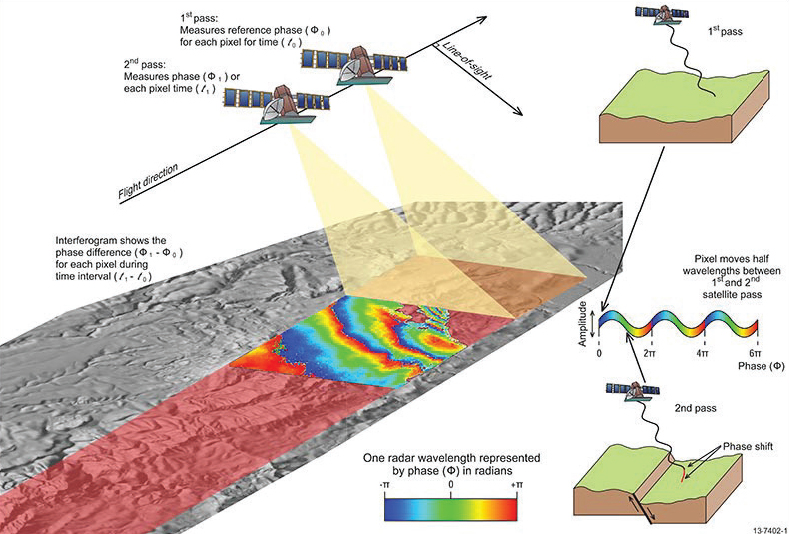
InSAR provides very high precision measurements of ground deformation over time. Dr. Estelle Chaussard (University of Oregon) shared information about how InSAR1 functions; the satellite measures the precise distance between its orbit and the Earth with a swath approximately 100 km wide and the satellite repeats the same measurement to provide precise information over time about how the ground has moved (see Figure 3.1). This technology can help with mapping land subsidence associated with groundwater extraction in areas previously undocumented, without requiring ground access. InSAR provides a high level of precision (on the order of mm/yr of ground deformation) and spatial resolution (each pixel is 10-30 m) which covers hundreds of thousands of km2. Combining this information with in situ data, Dr. Chaussard provided an example to illustrate estimates of the storativity (a measure of the volume of water that will be discharged from an aquifer per unit area of the aquifer and per unit reduction in hydraulic head) on a basin-scale in the Silicon Valley. The high temporal repeat and high spatial coverage allows for the parameterization of the aquifer system at the scale of the entire aquifer. Statistical methods can then be used to identify signals with variable spatial and temporal patterns embedded in a long time series of deformation. She also discussed how deformation measured by InSAR, when calibrated with well data, can predict water level (or head) changes. Combining deformation and water data, one can estimate the storativity and can use the information to predict where the well level will be, with approximately 70 percent accuracy in the Silicon Valley example. In other words, if constant well monitoring is not available, ground deformation can be used to bridge the gaps in data and help characterize water level changes.
Future SAR satellite missions with high repeat and global coverage will be key to improve understanding, especially utilizing free and open access data. For example, the NASA-ISRO Synthetic Aperture Radar (NISAR) mission, to be launched in 2022, will have a 12 day repeat everywhere on Earth. Dr. Chaussard also noted that combining GPS (surface water load) with InSAR (groundwater input and output) can help track recharge and discharge. InSAR can also be used to up-sample GRACE to reach management-scale leads toward fully remotely sensed groundwater management. One major challenge raised is characterizing how much water is left and usable in an aquifer system using remote sensing methods.
___________________
As noted earlier, GRACE2 is an important asset in groundwater research, which has been combined with other data sets to leverage their respective strengths. Dr. Isabella Velicogna (University of California, Irvine) discussed a number of topics, including GRACE data as an integrated measure of total water storage (TWS), fine scale variability, characterizing regional drought evolution and its impacts using multiple remote sensing techniques (and developing a framework for drought forecasts), and comparisons with hydrological and Earth system models. Remote sensing observations are used as a proxy for water availability in an aquifer and although their capabilities have different sensitivities and data are collected at different spatial scales, they have been used together in a synergistic way. The average TWS information provided within the GRACE footprint has been shown to be representative of inter-annual variability at the finer spatial scale, and thus information from GRACE helps understand what is occurring at the subscale (Geruo et al., 2017). Using an example of a 2011 drought in Texas, she explored these different types of information to characterize the drought evolution and sensitivity as well as the response of the vegetation. Soil moisture was shown to be closely tied to precipitation and GRACE data agreed well until the 2011 drought, after which the signals were decoupled. This information was used to define a characteristic time scale for the variability and to understand the response of the system. In another example, a drought index was defined, which makes it convenient to compare different sources of information. In 2011, a different response to drought occurred, which was affecting surface moisture but GRACE
___________________
revealed that this did not affect groundwater resources (TWS). Dr. Velicogna also mentioned the GRACE drought severity index (DSI), which is complementary to the standard drought index. The GRACE DSI is global and fully observational, includes uncertainty, characterizes the bulk TWS, enables drought feature comparison across regions and periods, and includes anthropogenic contributions, which most models do not include.
Dr. Velicogna also discussed using GRACE to evaluate modeling in the Himalayan region. She discussed a comparison of GRACE TWS and a defined variable of TWS over the glacial region. Evaluating the model provides additional confidence in using the model for future projections. Inter-annual variability is captured well and achieves similar high values of water mass, but the models tend not to achieve the same low values of water mass, because the models do not include glacier melt. This evaluation has helped determine how well the model captures water sources, temporal changes, and the physical processes that control these changes. She also explored the use of GRACE in a diagnostic way to evaluate and improve model output. Using a water balance model, separating the upper and lower Indus basins, and comparing the TWS from GRACE with the one from the model generated using different precipitation forcing, the GRACE data helped evaluate the best model in the upper basin. In the lower basin, differences were caused by incorrect estimates of human-induced groundwater withdrawal.
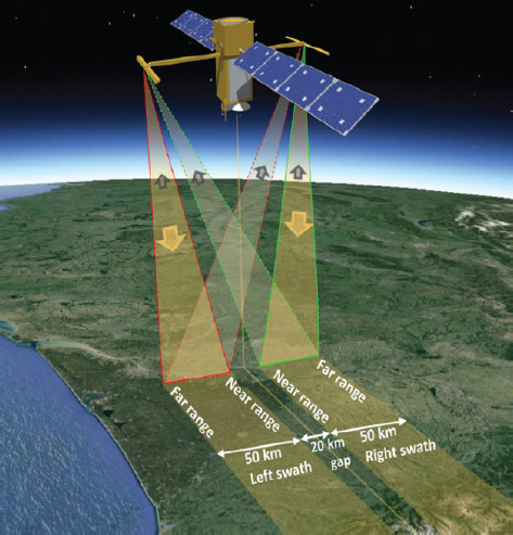
The SWOT3 mission was recommended by the 2007 Decadal Survey (see Figure 3.2; NRC, 2007) as a wide-swath altimetry mission to address key science objectives in hydrology and oceanography. Dr. Edward Beighley (Northeastern University) discussed the SWOT mission objectives which include providing a global inventory of surface water bodies and characterizing storage changes and river discharges, as well as characterizing ocean mesoscale and submesoscale circulation. SWOT is set to launch in fall of 2022 and will measure rivers wider than roughly 50-100 m in width and water bodies greater than 100-250 m × 100-250 m in surface area. Measurements obtained will include surface area, elevation, slope of the water surface, and backscatter. Given that SWOT has a 21-day near-global orbit cycle, lakes and rivers will be measured two or more times, depending on latitude with greater overlap near the poles, during the 3-week orbital cycle. A novel feature of SWOT is that it simultaneously measures surface water extent for lakes and rivers, determines the water elevation of lakes, calculates the slope of water in rivers, and resolves with high resolution the elevation of the river water surface along the imaged path.
___________________
Dr. Beighley noted that river discharge is calculated from changes in water surface elevation and width, slope, and some fitting. Changes in area can be observed, but the bathymetry below will not be observed, so some assumptions are expected to be made regarding bathymetry and roughness before river discharge is estimated. SWOT will not be able to monitor all rivers globally, but will systematically measure discharge on rivers 100 m and wider, with a goal to measure discharge on rivers 50 m and wider. More measurements will be obtained at the poles than at the equator, though most locations will be measured at least twice every 21 days. The spacing of the measurements are not uniform, and this may pose challenges for researchers working with the data. It will likely be possible to fit the streamflow distributions and estimate the quantiles very well; therefore, it will also likely be possible to obtain a good understanding of the basics of flow distribution characteristics at various gauges. Baseflow estimates are likely to be the best SWOT derived discharges for large rivers. Lake and reservoir storage changes plus potential inflow and outflows are likely to improve understanding of basin water balance, which can then help improve understanding of the groundwater system.
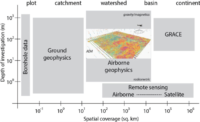
Airborne geophysical data can be used to map the sub-surface and geological structures related to groundwater aquifers. Dr. Burke Minsley (USGS) illustrated a grid of borehole data used to map the base of aquifer elevation in the lower Mississippi River Valley. This system of ~10,000 boreholes (100 m deep) costs approximately $300M and takes years to decades to complete. In comparison, a data set collected with airborne geophysics was obtained in 3 months with a cost under $1M and can provide a high resolution view of the same information. This is a huge technological transformation in terms of mapping the sub-surface. In this sense, airborne geophysics fills a critical scale-gap in Earth observation and mapping sub-surface geology at the watershed to basin scales (see Figure 3.3). Many different types of commercial airborne systems are available and typically fly at approximately 30-100 m above ground on the order of 100 km/hr. Some instruments are more effective at detecting specific targets, depending on the problem being explored. For example, helicopter systems are better in rough terrain and provide higher resolution, however fixed wing systems are better at covering larger areas in more gentle terrain. All of these systems rely on the physics of electromagnetic induction and map electrical resistivity in the sub-surface. In fact, some instruments can make these measurements as deep as 500 m. At a small additional cost to the electromagnetic survey, additional sensors can be deployed on the same aircraft. Radiometric data (in the upper 20-30 cm) can provide information about soils and recharge, and magnetic data (at approximately 100 m) can also be detected and provide information about basement structure.
Using a detailed example of these data in the Lower Mississippi Valley, Dr. Minsley showed the morphology of the channel systems using shallow depth information, including abandoned channels, present day meanders, and backswamp deposits of fine grain sediments and clays. The example also shows the imprint of an ancestral abandoned channel, without a surface expression, that can be an important pathway for groundwater. The data can be interrogated in 3D as well. Interpretive surfaces including the base of the confining layer and the base of aquifer elevation can then be created and shared with hydrologists and groundwater modelers to help define groundwater structure, calibrate the models, and quantify uncertainty. Less
than 2 percent of the United States has been studied using these methods, but it is a promising technique for future work.
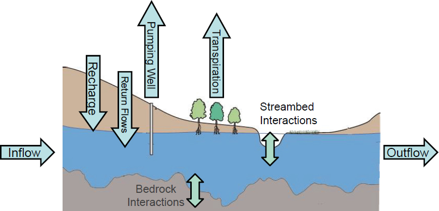
To wrap up the panel remarks, Dr. Jim Butler (Kansas Geological Survey) shared an example of the insights that can be gleaned from a simple aquifer water balance (see Figure 3.4). The cross section illustrates an unconfined aquifer with the major components of the aquifer water budget highlighted with arrows. While it would be ideal to precisely quantify each individual component of the budget, this is currently not possible. The question of where research efforts could be focused to quantify these components depends on the questions that are being asked. For example, in many parts of the world, it would be desirable to understand questions associated with irrigated agriculture and the aquifer response to pumping changes, whether they be mandated by management agencies or a product of climatic trends. To illustrate, Dr. Butler pointed out that in western Kansas, the goal is to extend the lifespan of irrigated agriculture, which is largely supported by pumping of groundwater, thus pumping needs to be reduced (there are no surface water resources available). It is important to consider that reductions in pumping means taking on risk on the part of the irrigator, and thus has economic implications; high confidence in the research is crucial.
Although, as noted, most components of the water balance cannot currently be quantified with much confidence, it is possible to quantify groundwater pumping with confidence through the metering of wells. Dr. Butler pointed out that, by grouping together all other aquifer inflows and outflows into a single term (net inflow), the aquifer water balance equation can be rewritten as water volume change equals net inflow minus pumping. In the High Plains aquifer in Kansas, more than 95 percent of the high capacity pumping wells are metered. These measurements are reported annually and subject to regulatory verification, and Dr. Butler emphasized the importance of the verification step. The rewritten water balance equation can then
be used in the Kansas example to directly calculate net inflow from field data with an approach developed by Dr. Butler and colleagues. In western Kansas, this net inflow term appears to be essentially constant in time, at least over the past 20 years (though in central Kansas it varies a small amount). Thus, the net inflow of the recent past can be used to estimate the impact of pumping reductions for the near future (i.e., the next few decades). A simplified approach like this can be a very useful tool for the irrigation community to assess the near-term prospects of the groundwater resources on which they depend. The problem is that metering with regulatory oversight is very rare in the world’s heavily stressed aquifers, making it difficult to realize the power of this approach. However, as discussed in earlier presentations, estimates of water volume change in the aquifer and pumping can be obtained via various remote sensing approaches. Armed with this information, net inflow can be calculated, and short term predictions can be made on aquifer response to management changes and climatic stresses. Thus, there is potential for the remote sensing community to provide information that can be a valuable asset for management of groundwater resources.
DISCUSSION
Knowing that researchers have mapped coastal bathymetry using optical remote sensing, Dr. Shaffiq Somani (World Bank) asked if those same techniques have been used to map rivers and bathymetry or depth of the water. Dr. Beighley replied that he is unaware of any widespread use of remote sensing to obtain river channel bathymetry. IceSAT-2 can provide some data on water at several meters depth, but it depends on the clarity of the water and the sediment load. Dr. Somani also pointed out that InSAR data have been used to determine water surface
elevation, and asked if it can be applied to determine water surface elevation of streams as well. Dr. Chaussard replied that InSAR has been used to determine water surface elevation in the Everglades, for example, and that changes in the water can be tracked over time. Panel moderator, Dr. Cathleen Jones (Jet Propulsion Laboratory) added that emergent vegetation is needed to map water surface change with InSAR because double bounce scattering is required; it does not work in open waters, but it works well in swamps.
Dr. Person mentioned a study where saline water discharge can be determined by deducing flow phenomenon using SkyTEM and asked if mapping saline discharges near the surface may be useful moving forward. Dr. Minsley noted that SkyTEM is one type of airborne system, and that there are two primary controls on the electrical properties that are measured: geology and salinity (a dominant signal that overwhelms the geology signal). This mechanism has been used in several locations, but the water must be saline. Otherwise, the structures that hold the water can be seen, but not the water itself.
Dr. Lakshmi asked about the SWOT elevation accuracy of +/− 10 cm, specifically noting that it may be too coarse. For example, in the peak of summer evaporation, there may be up to 10 mm/day of evaporation. Dr. Beighley noted that this is more about mission requirements and that researchers are hoping to achieve better accuracies, after spatial analysis of the measurements. Dr. Rodell also asked about the SWOT 10 cm requirement for elevation and noted that it will give the slope of the river which is a large part of what will be used to estimate the discharge. He wondered if the calibration of SWOT from one river where discharge measurements are available can be applied to another where discharge observations are not available. Dr. Beighley noted that there are several discharge algorithms that are using measurements of river width, elevation, and slope. All are estimating missing bathymetry and roughness, which may be static or change with discharge or water surface elevation and discharge rate. The product for discharge does not have a mission requirement in terms of accuracy, but it will be difficult to estimate. Because there are so many different discharge algorithms, some methods are better than others in certain types of rivers in terms of how to estimate these missing quantities. There will not be a discharge product that produces one number, rather the result will be all of the algorithms and the values they obtain for the missing bathymetry and the roughness to obtain discharge. Thus, each river will give multiple estimates of discharges depending on the different methods. Studies are ongoing to quantify which approaches work better for which types of hydrodynamic situations, to map all of the various scenarios, and to test the algorithms in different situations.
Dr. Singha asked about ground-truthing and validation and how to determine that remote sending imaging has validity on the smaller scales. Dr. Beighley noted that there is work on the calibration and validation program now for SWOT. There are a series of three different levels of calibration and validation sites globally, and the best sites will be instrumented with pressure transducers along sections of the river, where measurements will be made in situ during overpasses and a fast sampling phase at the beginning of the project. A great deal of field work will happen along sections of unregulated river and that will serve as the gold standard in terms of calibration and validation. There will also be work at sites that have USGS streamflow gages,
and traditional gage sites will be used as well. Dr. Minsley noted that on the geophysics side, it is difficult to access the sub-surface at the depths investigated, but boreholes are a good starting point. A number of companies have standards to measure the same locations and ensure that the systems are measuring the same response over a known location, and this is a requirement at USGS at the beginning of a survey. Dr. Chaussard noted that for InSAR data, it is a straightforward comparison with GPS data and leveling surveys that are entirely ground-based. GRACE is difficult in terms of calibration and validation, because it observes places where there is no signal. There is work to compare these data with places where independent observations exist, and to compare with groundwater well observations, but this kind of work has to take place where the same variables are being measured. Dr. Butler noted that some researchers are trying to obtain remotely sensed estimates of pumping and compare it to the ground-truth of the metered data that are available.
An online participant asked about the scale effects of net inflow. GRACE, for example, operates on such a large scale, it is unclear how net inflow can be interpreted from the data. Dr. Butler noted possibilities to work on finer scales with GRACE and other data. Dr. Velicogna noted different approaches to construct the signal in an aquifer; the goal is to get the total change, close the water budget for a specific drainage basin, and then isolate the components.
Following the second set of breakout group discussions, representatives from each group presented their thoughts on research frontiers and advances in technology that enhance the ability to understand groundwater recharge and flow, especially in areas where in situ data are sparse or inaccessible. The desired frontiers depend on the scale of the problem. Multiple technology advancements are maybe needed as well as a framework or methodology to integrate all of the different measurements. As noted earlier, GRACE is a helpful tool to close the water balance. Observing water storage change at large scales, with multiple rivers at SWOT scale within the region of study, can help distribute that change and provide a way to downscale GRACE observations. Two pairs of these satellites could help reduce uncertainty. Other remote sensing frontiers include evapotranspiration and runoff from SWOT, which also helps close the water budget; InSAR for calibration and validation; and GPS that can measure surface water changes and how surface water interfaces with the aquifer. If possible to obtain, drone-based measurements of temperature, evapotranspiration, and NDVI to observe vegetation could be crucial for future research. Airborne geophysics on a global scale, especially combined with remote sensing data, could help to link surface- and sub-surface water movement. Access to nuclear magnetic resonance to measure moisture content can provide a way to estimate recharge. As previously mentioned, isotopes can be used to characterize systems, and new methods to determine water quality using remote sensing will also be important.
Several participants mentioned smart adaptation of computational advances, including geostatistics, 3D kriging4, artificial intelligence, machine learning, and other data analysis techniques. Leveraging technology to enhance citizen science as well as the availability of newer and less costly sensors may be an innovative approach to obtain needed in situ measurements. Com-
___________________
4 3D kriging is a geostatistical interpolation method that uses Empirical Bayesian Kriging (EBK) methodology to interpolate points in 3D.
bining hydrological modeling and remote sensing can lead to advancements in downscaling large scale data to more useful resolutions, and incorporating climate projections to begin strategic planning for future management of groundwater recharge methods will likely be crucial.
Participants were also asked about identifying when and where aquifers are being recharged and the source of the water, as well as the spatial and temporal scales desired to meaningfully quantify recharge processes. Boreholes provide continuous data, but are limited to specific small-scale locations; GRACE is useful on the large scale. The scales of recharge depend on the type of climate and land surface, and the types of recharge (inflow, net, or lateral flow). Continuous monitoring is desired from in situ measurements for managing seasonal changes in recharge. If the aquifer is elastic, it may be possible to use InSAR, which could have value for injections. Inference may be based on topographic, geologic, and ecologic (if water table is shallow) information. Sources of water may also be inferred from recharge data depending on the location, or from isotopes, biogeochemical markers, and genetics of microbial communities in the water. Models will be key to integrate and validate data and to put constraints on the different components. Precipitation and ET data, better understanding of groundwater and surface water interactions, and runoff are key data for modeling improvements. Finally, several participants noted that it will be crucial to understand human processes such as land cover and land-use change and the implications for recharge. It may be useful to consider soft data types and interviews with communities where data are sparse or lacks instrumentation.
In thinking about NGA resources that could help make meaningful progress (see Box 3.1), participants noted that it is important to understand what resources might be made available to the research community. Box 3.1 provides some examples of information that would help advance scientific research if it were made available by NGA or other organizations.
Finally, the groups were again asked to provide examples of successful collaboration opportunities and partnerships. Suggestions included: learning what works and what does not work for the four transboundary aquifer treaties that currently exist; lessons from interstate compacts on water sharing and usage in the United States; GEOGLOWS, a multi-government consortium that shares water sustainability data; the USGS Powell Center; possible groundwater components of Science for Nature and People Projects (SNAPP); and utilizing specific locations such as Upper San Pedro, Arizona, which illustrate international collaboration opportunities to understand groundwater movement between Mexico and the United States.


