
3
Natural Resources and Environmental Context
The natural setting at Owens Lake both influences and is influenced by decisions concerning dust control. A complex array of factors related to climate, hydrology, habitat conservation, mining, and cultural resources provide an important context for evaluating dust control measures (DCMs). In this chapter, the committee discusses key factors within this broad context with implications for dust management.
CLIMATE, HYDROLOGY, AND WATER RESOURCES
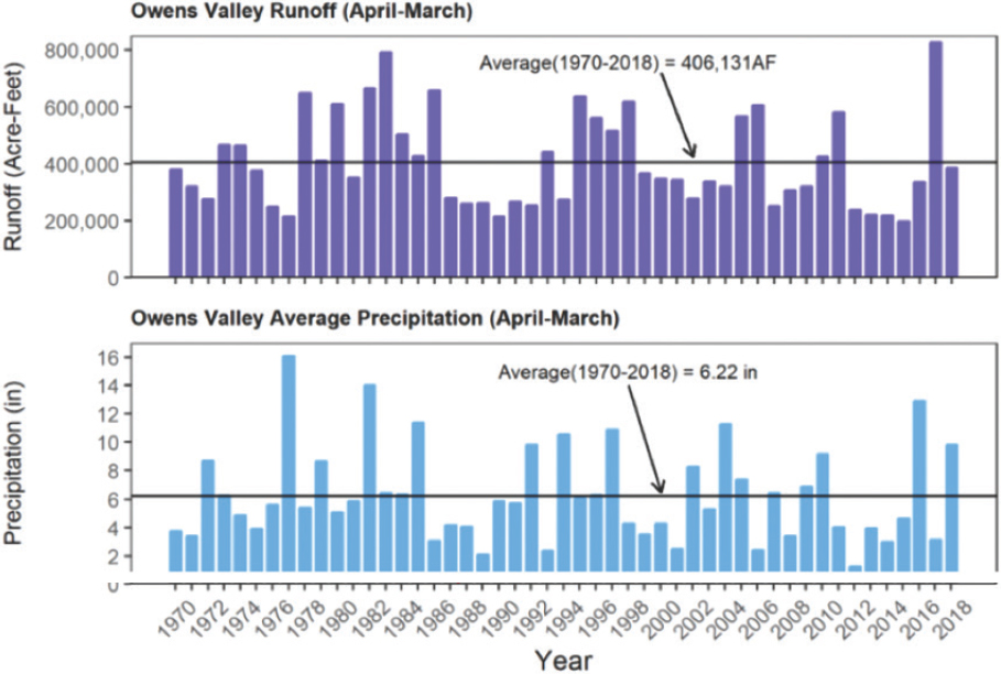
The Owens Lake watershed is a closed basin located on the east of the Sierra Nevada and western edge of the Great Basin, at the southern end of the Owens Valley (Smith and Bishoff, 1997) (see Figure 3-1). The presence of the Sierra Nevada range to the west results in a significant precipitation shadow (Danskin, 1998). Owens Lake receives limited precipitation and significant sunshine, with generally low humidity that results in high potential evapotranspiration. The 50-year average annual rainfall on the valley floor is 6.22 inches, while the average annual snowfall at high elevations in the watershed at the Mammoth gauge is about 43 inches (as snow water content; Duell 1990; Hollett et al., 1991; LADWP, 2019a). Figure 3-2 highlights long-term cyclicity in the precipitation record—in recent years typically consisting of a few years of above average precipitation followed by 3-5 years of below average precipitation.
The Owens Valley drains an area of approximately 3,300 square miles, and the hydrologic system in the valley consists of surface water and groundwater. Both have been significantly altered by water extraction over the past century through surface water diversions from the Owens River to the city of Los Angeles and groundwater pumping in the valley.
Surface Water
The complex and altered surface water system of the Owens Valley includes the Owens River, tributary streams, the Los Angeles Aqueduct, reservoirs, interbasin transfers from the Mono Lake watershed, and Owens Lake itself (see Figure 3-1). The long term (48-year) surface
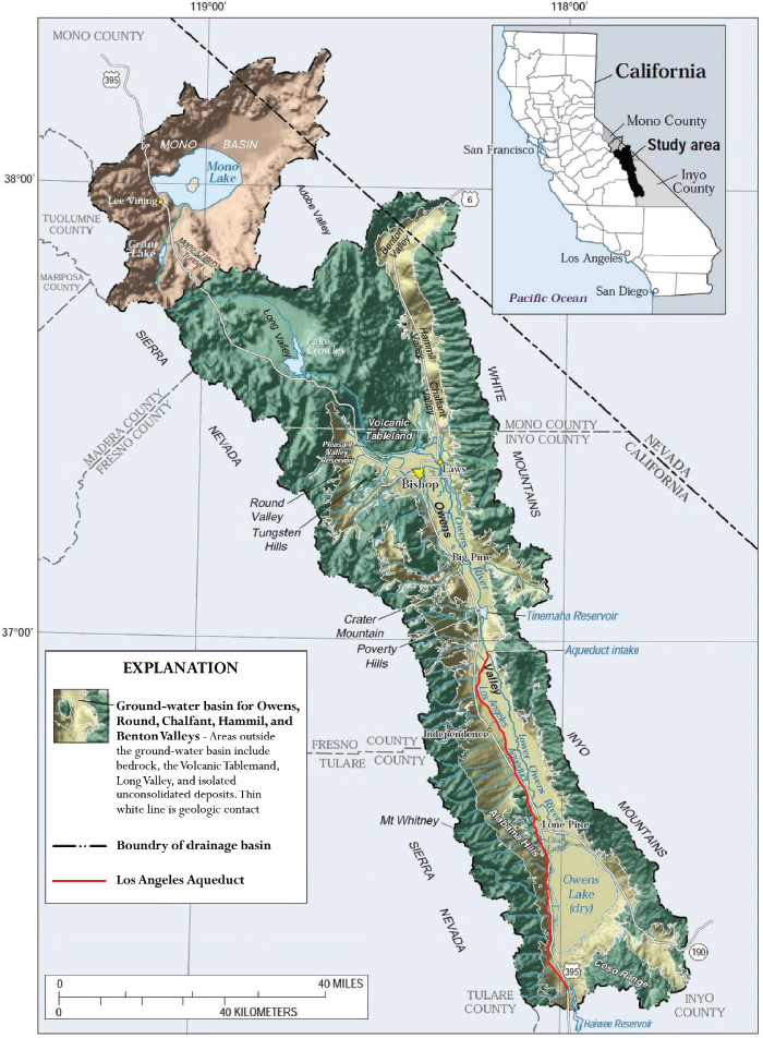
NOTES: The Owens Valley is shown in green, but the headwaters of the Owens Valley include diversions from the Mono Lake Basin (shaded brown) via the Mono Craters Tunnel. The Los Angeles Aqueduct begins south of the Tinemaha Reservoir, about 40 miles north of Owens Lake.
SOURCE: Edited based on https://www.usgs.gov/centers/ca-water/science/owens-valley-hydrogeology (accessed January 28, 2020).
SOURCE: LADWP, 2019a.
runoff in the basin averages 406,000 acre-ft/year, but Figure 3-2 shows the strong variability in precipitation and water runoff in the Owens Valley. During drought years (2015 for example) runoff was about half the long-term average, while in 2017, runoff was approximately double the average.
Since 1913, the vast majority of surface water flows, which once sustained Owens Lake as a closed-basin lake, have been diverted into the Los Angeles Aqueduct. This diversion led to desiccation of the lakebed by 1926. The present Owens Lake consists of large areas of exposed lakebed and a region of brine-saturated surficial salt deposits known as the “brine pool,” which has nearly 30 percent salinity (increased from approximately 6-7 percent prior to diversions) (Herbst and Prather, 2014; Ver Planck, 1959).
The Los Angeles Aqueduct exports surface water along with additional water from groundwater pumping out of the Owens Valley (see Figure 3-1). The aqueduct begins about 40 miles north of Owens Lake and consists of more than 200 miles of canals, tunnels, and conduits. During typical climatic conditions, only a small amount of water is discharged
into Owens Lake, which sustains the brine pool and appropriate conditions for mining (see Mineral Resources later in this chapter). Recently, only during the wettest years (e.g., 2017) when aqueduct capacity is exceeded, does significant surface runoff reach Owens Lake. Under extreme flood conditions, unmanaged flows can enter Owens Lake from the north through the Owens River or via numerous smaller mountain drainages to the east or west of the lake. Water for the DCMs at Owens Lake is supplied by the aqueduct.
Between 1950 and 1970, approximately 300,000 acre-ft/year was consistently exported to Los Angeles via the aqueduct. By 1971, those exports increased with an expansion of the aqueduct capacity. However, in the past 30 years, multiple legal challenges, including disputes over Mono Lake diversions and concerns over groundwater over-pumping, and several severe droughts have significantly affected both the availability and export of water (see Figure 3-3). Since 1994, when minimum flows into Mono Lake were established, flows in the Los Angeles Aqueduct have ranged from a low of 58,000 acre-ft/year to a high of more than 450,000 acre-ft/year. The average annual supply from the Los Angeles Aqueduct since 1994 is approximately 250,000 acre-ft/year, although average supplies over the past decade when California experienced a multiyear drought dropped to 170,000 acre-ft/year (Valenzuela, 2019b).
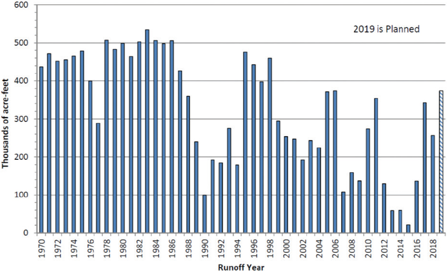
NOTE: These totals do not include water used for dust management at Owens Lake.
SOURCE: Solis, 2019.
Groundwater
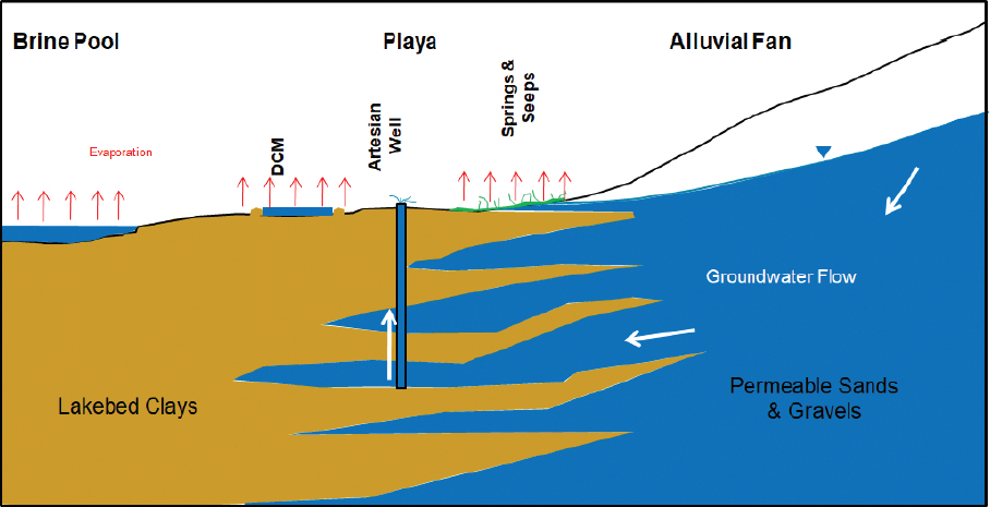
Both shallow and deep groundwater upgradient in the Owens Valley and at the margins of Owens Lake is generally fresh. Groundwater is used locally for municipal water supply in Owens Valley communities, for agriculture, and for commercial bottled water production. Shallow groundwater (<50 feet) directly beneath Owens Lake is saline to hypersaline, reflecting the evaporation and concentration of salts that occurred in recent history and following the diversion of the Owens River and subsequent near desiccation of Owens Lake. Deeper groundwater beneath the lake ranges from brackish to near seawater salinities and represents fossil groundwater associated with higher lake stands through the Pleistocene (Smith and Bischoff, 1997).
On the lakebed, shallow groundwater is generally close to the surface (Tyler et al., 1997), with reported depths between 3 and 8 feet. Springs and seeps can be found on the margins of the lake at the base of alluvial fans (see Figure 3-4). A few artesian wells exist on the lakebed that tap into confined aquifers.
The depth to shallow groundwater at Owens Lake likely varies on annual and longer time scales. However, as is common on many saline playas, the shallow groundwater table beneath the lakebed generally remains below the land surface. The geologic material that makes up the lakebed ranges in texture from coarse sand to salt-crusted clay sediments (Tyler et al., 1997; see Figure 4-7). Evaporation from the groundwater is limited by either the coarse texture of some of the surface material or the presence of salt crusts. Tyler et al. (1997) reported annual
SOURCE: Jorat, 2019.
evaporation rates from the groundwater table at several different areas of the dry lakebed to be quite low, ranging from 88-104 mm/yr (3.5-4.1 inches/yr). Although small, capillary-driven evaporation combined with the presence of saline shallow groundwater in many areas of the lakebed leads to the development of salt crusts and salt-cemented sands near the surface. Total lakebed evaporation would also likely include most of the annual precipitation falling on the lakebed as suggested by Malek et al. (1990).
An increase in groundwater pumping in the Owens Valley between 1970 and 1984 led to an overdraft of the groundwater basin and a sizable drop in groundwater levels, primarily in the northern half of the Owens Valley (Danskin, 1998), which led to loss of groundwater-dependent vegetation (Elmore, 2003; LADWP, 2019a). This habitat loss led to active enhancement and mitigation efforts by the Los Angeles Department of Water and Power (LADWP) and gradual reduction in groundwater pumping. In 1991, the county of Inyo and the LADWP agreed on a long-term management plan.1 The plan, which has since been supplemented by additional agreements, limited rates of withdrawal for LADWP considering local groundwater recharge rates and withdrawals from other users to mitigate impacts of groundwater mining (LADWP, 2019a). Since 2000, LADWP has pumped on average 70,000 acre-ft of groundwater annually from the Owens Valley (LADWP, 2019a). LADWP is currently investigating the potential use of groundwater withdrawn from beneath Owens Lake for dust control efforts as part of the Owens Lake Groundwater Development Program using an adaptive management approach.2 Additional detail on Owens Valley hydrology and groundwater budgets can be found in Hollett et al. (1991) and Danskin (1998).
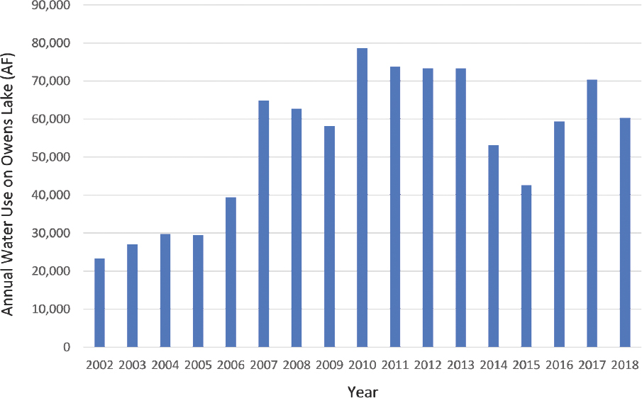
Owens Lake Context for Water Management
Since 2000, LADWP has been using a significant volume of water from the Los Angeles Aqueduct for dust control on the Owens Lake bed. Currently, dust mitigation on the lakebed requires approximately 65,000 acre-ft/year (average of 2017-2018; see Figure 3-5). Recent use is similar (64,000 acre-ft/year) to the long-term average use from 2007 to 2018, and all of this water eventually evaporates. Since 2007, dust control used 31 percent of available LADWP water at Owens Lake (assumed to be a total of LADWP exports in the Los Angeles Aqueduct and Owens Lake water use), with a range of about 17 to 51 percent.
The extensive dust control infrastructure is vulnerable to precipitation extremes, which have occurred recently in wet years with high snowpack (e.g., 2017) and have caused damaging flood events and multiyear droughts that created challenges for regional water supply. During the extreme drought from 2012 to 2015 in California, insufficient water was available
___________________
1 See https://www.inyowater.org/documents/governing-documents/water-agreement/#AGREEMENT (accessed January 28, 2020).
2 See https://ladwp.com/ladwp/faces/ladwp/aboutus/a-water/a-w-losangelesaqueduct/a-w-laa-owenslakegroundwaterevaluation?_adf.ctrl-state=6ofsp1hv3_4&_a&&_afrLoop=6445882895763 (accessed January 28, 2020).
SOURCE: Valenzuela, 2019b.
to fully operate the existing Best Available Control Measures (BACMs) on the lakebed, and adjustments to the shallow flooding BACM requirements were made, including reduction of water use and changes in water application timing.
In recent years (2013-2017), water from the Los Angeles Aqueduct (including inflows from the Mono Basin) represented 19 percent of LADWP water supply sources (see Figure 3-6). Other sources include recycled water, groundwater, and imported water purchased from the Metropolitan Water District of Southern California. LADWP is working to reduce its reliance on imported water, such as water conveyed from the Sacramento Bay Delta and the Colorado River, and to increase the use of LADWP’s available local water supplies, such as Los Angeles area groundwater supplemented by enhanced recharge of stormwater. Under recent strategic plans, LADWP water supplies provided via the Los Angeles Aqueduct would increase from its current 19 percent to 42 percent of LADWP’s supply by 2040 (Cortez-Davis, 2018), primarily through water conservation efforts in the Owens Valley, including at Owens Lake. Owens Lake water conservation is intended to complement LADWP investments in recycled water, stormwater, and groundwater storage and additional efforts to reduce per capita water use through water conservation and efficiency projects to reach LADWP’s overall water supply goals.
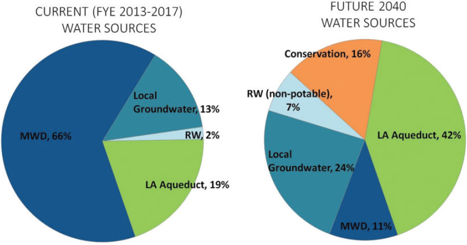
NOTES: Average water use from fiscal years ending in 2013-2017 was 530,000 acre-ft/year, and future 2040 use is projected to be 675,700 acre-ft/year (LADWP, 2015, 2017). MWD = imported water from Metropolitan Water District; RW = recycled water.
SOURCE: Cortez-Davis, 2018.
Climate Change and Water Management
Climate change in the 21st century is expected to have significant impacts on the hydrology and water resources of California, the Sierra Nevada, which supplies runoff to the Owens River, and to the Owens Valley itself. In general, warming climates are predicted to lead to an accelerated and more variable hydrologic cycle (NASEM, 2016). In California, Hayhoe et al. (2004) predict a 73-90 percent decrease in the snowpack of the Sierra Nevada by the end of the 21st century, a trend consistent with other studies of the region (Harpold et al., 2017; Klos et al., 2014; Reich et al, 2018). Although predictions of the future annual average precipitation are less reliable, warming temperatures are predicted to result in less total runoff and streamflow generation in the eastern Sierra (Hayhoe et al., 2004; Huang et al., 2018). Runoff would occur earlier in the season, including in mid-winter because of an anticipated increase in the rain-snow transition elevation in the Eastern Sierra.
The Sierra snowpack has typically served as California’s largest water storage reservoir. The water conveyance systems in the Owens Valley and in the headwaters have relatively small surface water reservoirs. Some groundwater recharge and recovery has been initiated in the Owens Valley, including surface flooding during the exceptionally high runoff year
of 2017, but groundwater storage is not widely developed. Therefore, warming temperatures mean that winter rain will quickly move down the watershed to the Owens River, producing river stages that peak in late winter and very early spring. This results in a mismatch in timing of runoff and demand, which will likely have significant implications for water management and for the design and implementation of water storage in this century and beyond (see, e.g., Hayhoe et al., 2004).
Climate change is also expected to significantly increase average temperature and consequently evaporation and evaporative demand by vegetation throughout the Owens Valley watershed. Using a simplified reference evaporation model (FAO-56), a 2°C warming will increase the evaporation rate at the Owens Lake by ~3.5 percent during the current dust control season. In the watershed, warming temperatures will also lead to greater snow sublimation, evaporation from open canals and reservoirs, and increased transpiration demand by vegetation, which will likely lead to less water available for either dust control or downstream demand. This double impact—of increased water demand for Owens Lake dust control efforts and a reduced water supply for dust control—is not conjectural, but simply a fact of warming average temperatures and the physics of evaporation.
Finally, climate change is expected to lead to more and greater extreme events, at both short time scales (local flooding and heat waves) and longer ones (more prolonged and deeper droughts [Diffenbaugh et al., 2015, 2017]). Short-term extremes, such as increased convective storm intensity, could affect the dust mitigation infrastructure through local flooding and sediment transport onto the dust control areas. Over the medium to long term, prolonged droughts will further reduce the availability of water for dust mitigation and downstream water use, as was seen in 2015 when LADWP halted flow through the Los Angeles Aqueduct to ensure that legal obligations for Owens Lake dust control and Owens River minimum flows were met (Barragan, 2015). Conversely, the extreme runoff year of 2017 led LADWP to issue warnings to the communities and lake resource managers to expect significant flooding and possible damage to on-lake infrastructure.
CULTURAL RESOURCES
Native Americans are an integral part of the Owens Lake ecosystem. The area was likely first populated at least 10,000 years ago, and until approximately 700 years ago, Native Americans in the region were highly nomadic populations that largely relied on animal resources (Basgall and McGuire, 1988; GBUAPCD, 1996). Climate shifted considerably during this time period, spanning relatively cool and moist conditions to warm and dry and thereby leading to variation in the availability and location of resources (Bagsall and McGuire, 1988). During an extended dry period from 750-950 years before present, the lake was likely dry, and Native American use of Owens Lake may have extended into the playa (GBUAPCD, 1996; Stine, 1994). Over the past 700 years, the Owens Lake area has been populated by
Paiute, speaking Mono language dialects, a division of Numic-speaking cultures (GBUAPCD, 1996). Particularly during the past 600 years, until Owens River inflows were diverted into the Los Angeles Aqueduct, wetland resources increased in and around Owens Lake. The Owens Lake area became unique in the Great Basin by supporting a shift from nomadic to more sedentary lifestyles, relying on both plant and animal resources around the lake (Binford, 1980; GBUAPCD, 1996), such as waterfowl, fish, freshwater mussels, brine shrimp, brine fly larvae, grasshoppers, caterpillars, grass and chia seeds, and tubers. The rich resources of the lake, extensive irrigation to promote food plants such as nutgrass (Liljeblad and Fowler, 1986), and extensive trade supported relatively high populations of Native Americans (as high as two people/square mile) compared to other areas in the Great Basin (Delacorte et al., 1995; GBUAPCD, 1996).
The long history of Native Americans at Owens Lake spanned natural variation in the lake level, and therefore cultural resources and historically significant sites exist across a broad band around the lake that reflects changes in shoreline elevation over time (GBUAPCD, 2016a). Cultural resources at Owens Lake have generally not been identified by LADWP or the Great Basin Unified Air Pollution Control District (District) until dust control efforts begin. During construction, the discovery of cultural resources requires their assessment to determine if they are eligible for protection under the California Register of Historical Resources, California Environmental Quality Act Guidelines 15064.5[b and c]), or California Public Resources Code 21083.2. If deemed eligible, buffer areas will be established to avoid further impacts. Recommendations of all cultural areas exempted from dust control will be informed by non-binding recommendations from the Cultural Resources Task Force (GBUAPCD, 2013a). Several sites on the Owens Lake bed have been deemed eligible for deferral, which must be considered in the management of Owens Lake. The locations and details of these archaeological and sacred sites are exempt from public disclosure, according to the California Public Records Act. Under the 2014 Stipulated Judgement for Owens Lake, “cultural and biological resource protection and mitigation shall be incorporated to the extent feasible as required by law into the design of dust control areas.”3
Local tribes who originally inhabited the Owens Valley are an integral part of the ecosystem and have a strong sense of ownership and stewardship in the valley. However, they control only a small portion of the territory they once controlled. They have requested that cultural sites are not damaged and that artifacts are not removed. Artifacts provide a tapestry of stories and traditions and are viewed as funerary out of reverence for ancestors and the traditions they handed down. Outside the context of their location, artifacts have far less significance.
___________________
3 Stipulated Judgment in the matter of the City of Los Angeles v. the California Air Resources Board et al. Superior Court of the State of California, County of Sacramento. Case No. 34-2013-80001451-CU-WM-GDS. Approved by the court on December 30, 2014. See https://gbuapcd.org/Docs/District/AirQualityPlans/SIP_Archive/2014_Stipulated_Judgment_20141230.pdf (accessed January 28, 2020).
To this end, culturally significant sites should preserve artifacts in place so that future generations may visit the sites and learn the stories of their ancestors.
Sites determined to contain eligible cultural and historic resources (as well as a buffer around them) have been initially excluded from dust control activities, but if found emissive after surrounding dust control is implemented, may be scheduled for dust control (GBUAPCD, 2016a). Agencies are interested in identifying new DCMs that could be implemented without land disturbance or heavy infrastructure. In planning any future dust control areas beyond the current ordered areas, advance consideration of traditional focal points of cultural activities, such as springs and wetlands, could help avoid inadvertent damage of cultural resources.
The tribes have requested that culturally and historically significant sites not be subjected to heavy machinery and leveling operations typically associated with DCM construction and that LADWP and the District secure roads leading to or near the sites to minimize looting and inadvertent destruction (Bancroft, 2013).
The tribal concerns extend beyond areas containing artifacts. The diverse habitats and geographic features are also valued cultural resources and a priority for protection. In written comments that accompanied the 2016 State Implementation Plan (SIP) (GBUAPCD, 2016a), Mary Wuester, Tribal Chairperson of the Lone Pine Paiute-Shoshone Reservation, expressed support for efforts to “enforce protection of the ecological gains made despite the industrialization of the landscape” in the face of “waterless and water neutral policies” at Owens Lake. Specific locations and environments became precious to the collective and individual conscience as memories and ancestral traditions became attached to them. Legends and stories have been passed down in oral traditions to amplify and explain the significance of specific events and locations. According to Katherine Bancroft, the Tribal Historic Preservation Officer of the Lone Pine Paiute-Shoshone Reservation, “Our family’s history is in the landscape. Not only are they destroying the proof of historic events and our prehistoric way of life, but they are changing the landscape and geology that our stories are built on.” Leveling of land, building of roads, installation of infrastructure, and other landscape modifications adversely impact these valuable cultural landscapes (Bancroft, 2013).
HABITAT RESOURCES
As currently managed, water-based DCMs at Owens Lake provide valued habitat resources that support productive food webs, which attract a diversity of birds and other species. This section outlines the habitats that exist at Owens Lake, with additional discussion of bird conservation efforts. This context is important to understand the potential implication of expanded use of waterless and low-water DCMs, which are discussed in Chapter 4.
A broad suite of stakeholders have contributed to the environmental priorities on Owens Lake, including the public, Native American tribes, and nongovernmental organizations such as the Audubon Society and American Bird Conservancy. Two agencies—the California State
Lands Commission and the California Department of Fish and Wildlife—have oversight roles regarding the use of individual DCMs at Owens Lake as they affect environmental conditions and habitat.
The California State Lands Commission has jurisdiction over approximately 89 percent of the historic lakebed because Owens Lake used to be navigable. This Commission is responsible for public trust interests, particularly protecting and enhancing natural resources, protecting and enhancing public health and safety, and respecting and protecting Native culture, values, and resources. Its priority public trust issues on Owens Lake include wildlife habitat, public access, recreation, aesthetic enjoyment/protecting the viewshed, and cultural resources. Any management or development activity on Owens Lake requires a lease to be approved by this Commission. For example, the Commission denied the lease for the moat and row dust control measure on a 3.1 square mile area for Phase 7a, because moat and row was deemed to be inconsistent with public trust values, such as habitat, recreation, and aesthetics (CSLC, 2010).
The California Department of Fish and Wildlife oversees the Cartago Wildlife Area on Owens Lake, 218 acres of freshwater wetlands and springs that provide important bird habitat. More importantly, it has jurisdiction over Owens Lake through permitting power that implements its mandate to conserve, protect, and manage fish, wildlife, and native plants, and the habitats needed to sustain the populations of these species. On the Owens Lake bed, there is a no net loss requirement of bird nesting habitat. In addition, the department’s 2010 Habitat Management Plan for Owens Lake (LADWP, 2010) requires no net loss of riparian or aquatic habitat functions, values, and acreage, with implementation of the dust control areas outlined in the 2008 SIP (GBUAPCD, 2008). The agency also has specific requirements for bird habitat management to protect shorebirds and the Snowy Plover on more than 1,500 acres of Owens Lake.
Habitats of Owens Lake
As in any arid region, the nature and distribution of habitats are strongly associated with water. Aquatic features such lakes, riparian areas, seeps, springs, and marshes provide high-value habitat for diverse plant and animal species (Fowler and Fowler, 2008; NRC, 1989; Robinson, 2018; Trimble, 1999).
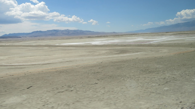
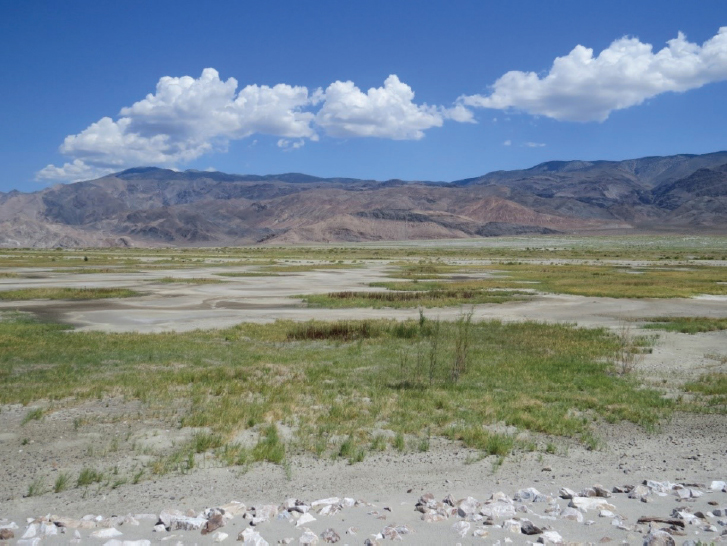
After the drainage of Owens Lake but before dust control efforts began, the dry lakebed was dominated by a remnant hypersaline brine pool and unvegetated playa (see Figure 3-7). This unvegetated playa covered most of the lakebed and thus spanned highly variable conditions, with sites ranging in soil type (e.g., lacustrine clay, silt, sand) and in depth to groundwater (0-25 feet). Salt crusts generally cover the surface. The barren playa, when wet, supports diatoms and cyanobacteria that are important food sources for invertebrates. Invertebrates are the only substantial populations of wildlife on the barren playa and are
SOURCE: Photo courtesy of Valerie Eviner, panel member.
largely concentrated in scarce areas of water, such as shallow pools. Invertebrate density is much higher and can support a more robust food web in perennially wet areas (LADWP, 2010). Before dust control efforts began, only 1-2 percent of the dry lakebed consisted of biologically valuable habitats such as scrub (e.g., shadscale, saltbush, and desert sink) and alkali meadows. The highest valued habitat covered approximately 412 acres (Sapphos Environmental, Inc., 2008), concentrated in scattered seeps and springs along the shoreline, and in the Delta and riparian and wetland habitats associated with the Owens River as it entered the lake (LADWP, 2010; Robinson, 2018).
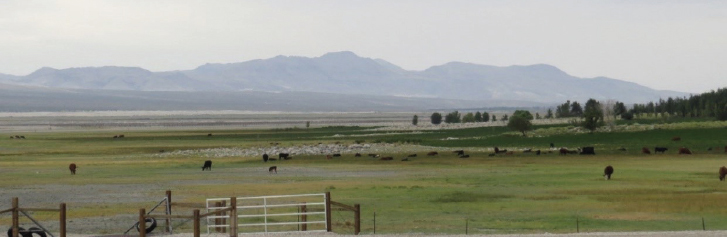
Extensive use of water for dust control via shallow flooding (see Chapter 4) unintentionally created habitat for vegetation and wildlife, as demonstrated by self-recruitment of saltgrass and tens of thousands of birds. A patchwork of habitat types have been created by different dust control strategies implemented within discrete “cells” of the lakebed, overlain across a landscape that varies in salinity and other environmental factors (e.g., soil type, topography, groundwater depth) (LADWP, 2010; Robinson, 2018). This engineered landscape supports key native ecosystem types and has created a series of novel ecosystems that are important habitat for diverse species. Bird populations in particular have increased since dust control management began, with the heterogeneous mix of habitat types providing foraging and nesting habitat for more than 100 bird species, leading the National Audubon Society and American Bird Conservancy to designate Owens Lake as an Important Bird Area.
The following sections describe the key habitats of the current Owens Lake system.
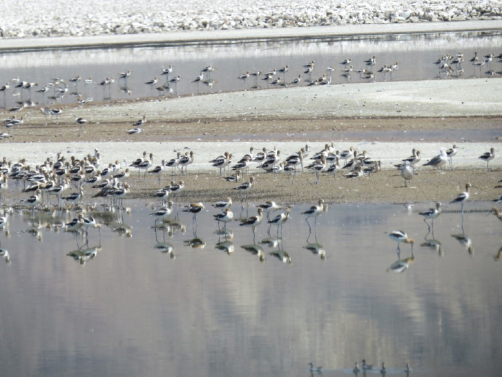
Shallow Flooding and Ponds
The shallow pools and ponds created by the shallow flooding BACM are the primary driver behind increasing bird populations in Owens Lake (Roberts et al., 2016) (see Figure 3-8). While the remnant brine pool is too saline to support the highly productive food web typical of alkaline lakes, the low- to moderate-salinity pools created by shallow flooding can support extremely high production of algae, which then support robust populations of brine flies along lake shores (Herbst, 2001). This robust food web is strongly dependent on management of salinity levels and on minimizing accumulation of toxic elements (Herbst, 2001; LADWP, 2010; Pavlik, 2008; Roberts et al., 2016). Since shallow flooding began, brine flies have become the most abundant invertebrate at Owens Lake, and most shallow flooding cells contain at least one of the two dominant brine fly species, Ephydridae auripes and E. hians. In at least some of the shallow flooding cells, brine shrimp (Artemia species) have also been detected (LADWP, 2010). Other diverse saline-tolerant invertebrates have also established in the seasonally moist or saturated areas created by dust control efforts, with densities highest in moderate- to high-salinity ponds (up to approximately 100 g/L salinity [Herbst, 2001; NRC, 1989]), and diversity highest in low-salinity ponds. These high inver-
SOURCE: Photo courtesy of Valerie Eviner, panel member.
tebrate populations, in turn, support high bird populations (LADWP, 2010; Pavlik, 2008; Robinson, 2018; Smith, 2000). Fresh and low-salinity pools also enhance self-recruitment of vegetation, particularly saltgrass and freshwater wetland plants, depending on the salinity (LADWP, 2010). The shallow flooding BACM creates aquatic habitats that are rare in the Owens Valley (Manning, 1992) and throughout the western United States—providing habitat that is critical for conservation at the local, regional, and global scales (Oring et al., 2013; Wilsey et al., 2017).
In addition to the important habitat provided by the watered areas, the engineered “cell” structure of the dust control projects lead to high area of roads and berms that act as shoreline for species such as brine flies and lizards. Dust control features provide three-fold more shoreline habitat than the historic lake shoreline (Robinson, 2018).
Alkali Meadows
Alkali meadows are common at springs and artesian well outfalls, largely on the edges of the lake (see Figure 3-9). They are increasingly prevalent in the Owens Lake bed, through self-establishment in lower-salinity shallow flood areas (see Figure 3-10) and through planting as part of the managed vegetation BACM.
Alkali meadows are state-designated sensitive habitat (Sapphos Environmental, Inc., 2008) and are hotspots of diversity, with more than 60 plant species common in the alkali meadows of the Owens Valley (Pavlik, 2008). In the Owens Lake bed, saltgrass (Distichlis spicata) is the most common vegetation type, because of both natural recruitment and use in the managed vegetation BACM (discussed in more detail in Chapter 4).
The composition of alkali meadows depends on the quantity and salinity of the water supply. Freshwater areas are dominated by grasses, rushes, sedges, and herbs, while more alkali areas are dominated by salt grass. Saturated alkali meadows are perennially wet and host the highest plant speciesand structural diversity, thus providing the most diverse habitat for animals. Moist alkali meadows have perennially moist soils, which result in lower plant structural and species diversity. These meadows are often dominated by saltgrass and can also host
SOURCE: Photo courtesy of Valerie Eviner, panel member.
SOURCE: Photo courtesy of Valerie Eviner, panel member.
other wetland species such as alkali pink (Nitrophila occidentalis) and yerba mansa (Anemopsis californica). When moist meadows are influenced by freshwater springs and seeps, they can also host other species including Baltic rush (Juncus arcticus species) and three square (Schoeno-plectus species). The third type of alkali meadow is dry alkali meadow, which is dominated by saltgrass but can also include Parry’s saltbush (Atriplex parryi), shadscale (Atriplex confertifolia), and alkali pink (Nitrophila occidentalis). These three types of alkali meadows are habitat for several plant species with high conservation priority (McLaughlin, 2010) and host a high diversity and density of invertebrates, birds, and small mammals, but are not key habitat for most reptiles (LADWP, 2010).
The managed vegetation BACM (see Chapter 4) has resulted in extensive establishment of saltgrass in playa areas that have been leached of salts (LADWP, 2010). These saltgrass meadows are key habitat for bird species that are distinct from those benefiting from shallow flooding, such as the Savannah sparrow, northern harrier, American kestrel, and horned lark. Other wildlife that benefit from this habitat type include harvester ants, spiders, grasshoppers, kangaroo rats, pocket mice, deer mice, voles, pocket gophers, jack rabbit, and desert cottontail. Tule elk may use these dry alkali meadows for resting, but saltgrass is low-quality forage and therefore unlikely important in their diet. There is some evidence that bobcat, coyotes, kit fox, gray fox, ringtail, and badger use these habitats in Owens Lake. A low diversity and
SOURCE: Photo courtesy of Valerie Eviner, panel member.
population of lizards utilize alkali meadows in Owens Valley, but they have not been detected in managed vegetation areas of Owens Lake (LADWP, 2010).
Other Wetland Habitats
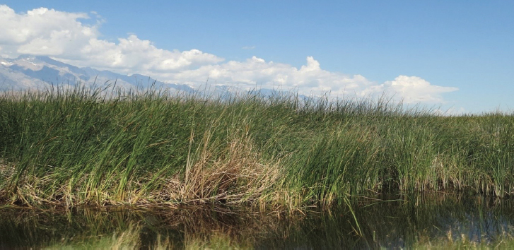
Springs tend to be dominated by freshwater and host diverse drought-susceptible plant species, aquatic bivalves, spring snails, and salamanders, all of which are at risk if the springs disappear due to extensive groundwater use (Pavlik, 2008). Marshes are high-productivity habitats dominated by plants such as reeds, rushes, cattail, and willows, and they support high populations of birds, small mammals, and mussels (Madsen and Kelly, 2008). The Delta (see Figure 3-11), where Owens River enters the lakebed, includes 755 acres of wetland, including marsh and alkali meadow, and a narrow strip of riparian woodland. This area is rich in plant and animal diversity, and it provides an important hotspot of diversity in the landscape, particularly for species relying on perennial sources of water (LADWP, 2010).
Upland Scrub
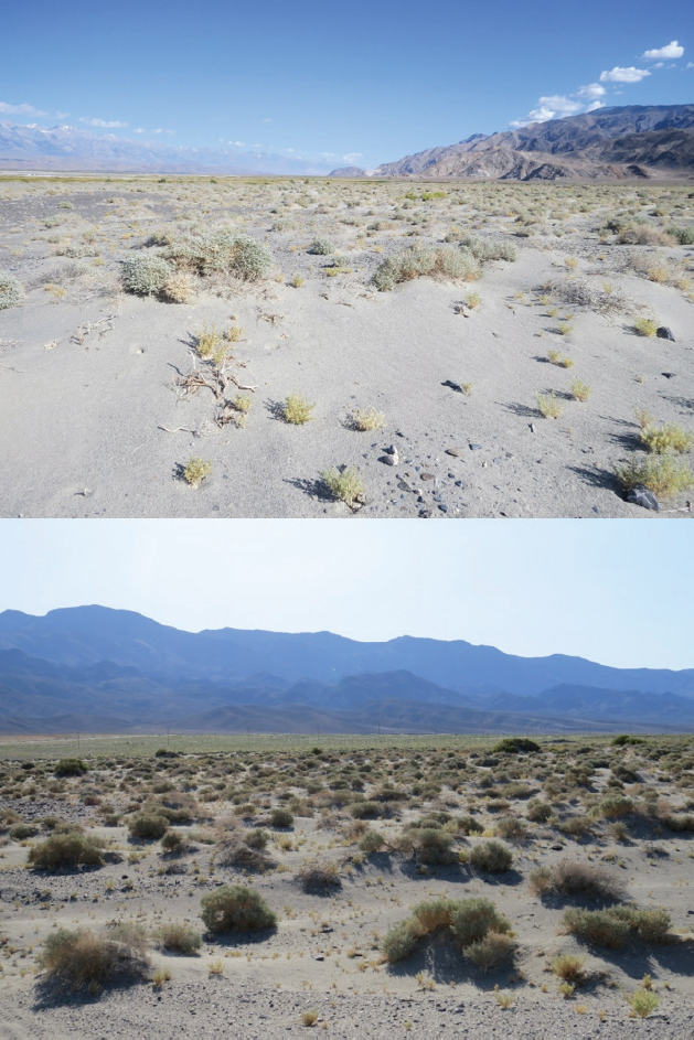
Various communities of upland scrub systems are common in the Owens Valley and can provide important habitat around the lake (see Figure 3-12) as well as on the lakebed. In general, upland scrub is dominated by widely spaced shrubs, with the species of shrub and the cover of herbaceous vegetation varying by scrub type. Scrub types vary substantially in whether they are dependent on groundwater, and if so, the depth of groundwater that they require (Elmore et al. 2003). Shadscale scrub is not reliant on groundwater (Elmore et al. 2003) and is common in well-drained alluvial fans around Owens Lake, but it can also be found in poorly drained alkaline basins adjacent to riparian areas, meadows, and playa
SOURCE: Photo courtesy of Valerie Eviner, panel member.
(LADWP, 2010; Smith, 2000). This habitat tends to be dominated by shrubs such as shadscale (Atriplex confertifolia) and budsage (Artemesia spinescens), but it can also contain winterfat (Krascheninnikovia lanata), an important winter forage for wildlife (MHA Environmental Consulting, 1994). Desert saltbush scrub has lower vegetation cover, more bare ground between shrubs, and a seasonal cover of annual plants. It is common in highly saline or alkaline soils, such as in playas (MHA Environmental Consulting, 1994), and is found in areas
both with and without shallow groundwater (Elmore et al. 2003). At Owens Lake, greasewood (Sarcobatus vermiculatus) and Parry’s saltbush (Atriplex parryi) dominate this habitat. The desert sink scrub is reliant on groundwater (Elmore et al. 2003) and has lower vegetation cover and biomass compared to the other scrub types. Parry’s saltbush dominates this habitat at Owens Lake, but there is also significant cover of greasewood, seepweed, and Atriplex species. In Southern Owens Valley on slopes and alluvial vans, creosote bush scrub predominates on well-drained soils with low alkalinity and salinity (Robinson, 2018).
In general, upland scrub provides important habitat for diverse insects, including ants, butterflies, wild bees, beetles, and grasshoppers. Of the Owens Lake habitats, upland scrub provides habitat for the most diverse numbers of lizards and snakes. Upland bird species that are supported include the sage sparrow, loggerhead shrike, and burrowing owl, as well as a number of thrasher species. Mammals include gophers, kangaroo rats, ground squirrels, rabbits, coyote, kit fox, bobcat, and various species of mice (LADWP, 2010). Several shrub species have been added to the managed vegetation BACM, and current studies at Owens Lake are assessing the details of shrub type, structure, and density needed to achieve required dust control (see Chapter 4).
Bird Conservation
Although the California Department of Fish and Wildlife recognizes the conservation importance of the diverse habitats at Owens Lake, habitat goals have almost exclusively focused on birds associated with standing water. The addition of water to the lakebed for dust control created extensive habitat for water birds, as indicated by Audubon’s designation of Owens Lake as an Important Bird Area and the Western Hemisphere Shorebird Reserve Network’s designation as a site of international importance. Shallow flooding during dust control season (October 16-June 30) has restored the role of Owens Lake as critical habitat for diverse bird species along the Pacific Flyway, with Owens Lake now hosting populations of more than 100,000 birds during the spring and fall migrations. Water coverage that extends into the summer supports summer breeding and provides juvenile habitat. Because of shallow flooding dust control efforts, Owens Lake is now one of the most important breeding sites in California for Snowy Plover, a state species of special concern that breeds from March to July (Oring et al., 2013). Tourism and recreation opportunities at Owens Lake have also been enhanced by the increase in bird populations and the addition of visitor areas and trails.
The habitats provided at Owens Lake have regional to global conservation implications, because migrant shorebirds rely almost exclusively on saline lakes in the Western United States, particularly throughout the Great Basin Desert (in which Owens Lake is located). These saline lakes support greater than 99 percent of North America’s population of Eared Grebes, up to 90 percent of Wilson’s Phalaropes, and greater than 50 percent of American Avocets,
and over the past 150 years, more than half of these lakes have shrunk by 50-95 percent (Wilsey et al., 2017). Since 1973, shorebird populations in the Great Basin region have decreased by 70 percent (Haig et al., 2019). Climate change will exacerbate this trend, leading to many Great Basin water bird species losing at least half of their current range by 2050 (Langham et al., 2015) and experiencing decreased quality of the habitat that remains, because of shorter seasons of water availability and increased salinity in the aquatic habitats (Haig et al., 2019). Although conservation of Mono Lake (approximately 140 miles to the north of Owens Lake) has been critical for bird conservation, Owens Lake provides migratory habitat that is unique from Mono Lake, because its lower elevation (3,600 feet, as compared to 6,378 feet) provides a longer season for migratory birds (California Department of Water Resources, 2004).
As is common in many alkali lakes, high bird populations are supported by extremely high production of algae, which, in turn, supports high populations of brine flies and brine shrimp. Long-term management of salinity levels to support this food chain is critical, because it is common in alkali lakes for salinity to build up over time, which decreases food chain productivity (LADWP, 2010; NRC, 1989).
The Owens Lake Habitat Management Plan lists 114 bird species observed at Owens Lake, including 27 species of shorebirds (LADWP, 2010). The Audubon birder’s checklist4 lists 15 bird species of special concern and a total of 270 bird species recorded in the area of Owens Lake. The diversity of species supported is due to the variety of habitats created by the engineered structure of Owens Lake, with distinct management cells that differ in depth of flooding, salinity, and surrounding habitats (such as the density of vegetation and type of substrate in which to nest) (LADWP, 2010; Robinson, 2018). This heterogeneous landscape supports the unique needs of different bird species, as demonstrated by the five focal guilds of interest: (1) breeding shorebirds, (2) migrating shorebirds, (3) breeding waterfowl, (4) migrating waterfowl, and (5) diving waterbirds. In each of these guilds, the most abundant species tend to be the most salt-tolerant species (Roberts et al., 2016).
The effect of changes in water use at Owens Lake on bird habitats and populations is difficult to quantify. Understanding the wildlife effects of changes in water-based dust control requires quantification of the spatial extent of standing water, the depth of that water, and the seasonality of its application relative to specific bird species that are being managed. A habitat suitability model is currently being used to track changes in potential habitat of the different bird guilds and to aid in long-term landscape-scale planning. A detailed analysis of this approach was conducted by Point Blue Conservation Science (Roberts et al., 2016) and is discussed in Chapter 5 of this report.
___________________
4 See https://ca.audubon.org/conservation/new-opportunities-birds-owens-lake and https://friendsoftheinyo.org/owens-lake-bird-festival-old/bird-checklist-owens-lake (accessed February 4, 2020).
Breeding and migrating shorebirds.
In their review of Owens Lake birds, Roberts et al. (2016) highlighted that the breeding shorebird guild should be the highest priority for habitat management because Owens Lake has great potential to provide important breeding habitat for salt-tolerant shorebirds, which is extremely rare in the region. Changes in management of the shallow flooding areas could further enhance the breeding shorebird habitat by extending shallow flooding periods into July and August, thus providing rare habitat for migrating birds at this time of year, extending the breeding season, and providing habitat for juveniles. These pools could also be managed to decrease salinity where it limits invertebrate productivity and shorebird presence (Roberts et al., 2016).
Two important shorebirds, the Snowy Plover and American Avocet, commonly breed in Owens Lake dust control areas and perimeter wetlands, but use distinct habitats (Roberts et al., 2016). The Snowy Plover requires relatively shallow water for feeding (1-2 cm [0.4-0.8 inches] depth) (Roberts et al., 2016). Brine flies are its primary food source, but it can also feed on other invertebrates (LADWP, 2010). In contrast to the Snowy Plover, the American Avocet can feed in relatively deeper water (15-25 cm), feeding on brine flies and brine shrimp. Other species in this guild are unlikely to be breeding in Owens Lake currently (Roberts et al., 2016), but as alkali meadow vegetation becomes more prevalent in the Owens Lake playa, it is expected that suitable habitat for the Long-billed Curlew and Wilson’s Phalarope may develop (LADWP, 2010).
The Snowy Plover is a California State bird of special concern and thus is a focus of management on Owens Lake. In addition to its requirements of no net loss of aquatic habitat functions, values, and areas (compared to the 2008 conditions), the California Department of Fish and Wildlife has established specific requirements in perpetuity to protect shorebirds and the Snowy Plover:
- Manage 1,000 acres for shorebirds and Snowy Plovers.
- Maintain a baseline population of 272 Snowy Plovers, including a minimum 523 acres for Snowy Plover habitat (e.g., shallow flooding of 12 inches of water or less, in close proximity to exposed sand or gravel sites for nesting). This requirement is distinct from the 1,000 acres managed for shorebirds in general.
Pools managed for Snowy Plover maintain flooding later into the summer (July 21) compared to the standard shallow flooding BACM (LADWP, 2010).
Migrating shorebirds make up a large population of Owens Lake birds seasonally, with their highest use of the lake occurring during the spring and fall migration seasons. They eat aquatic and terrestrial invertebrates, as well as seeds. The most abundant migrating shorebirds include American Avocet, Western and Least Sandpipers, and Wilson’s and Red-necked Phalaropes. They are a diverse guild, with species differing in salinity tolerance and preferences for foraging habitats that range from dry surfaces to deeper ponds. Thus, this guild is
particularly difficult to model based on habitat, which is the approach currently used to plan for and track changes in bird habitat at Owens Lake (Roberts et al., 2016).
Breeding and migrating waterfowl.
Before the shallow flood BACM was implemented, waterfowl at Owens Lake were restricted to artesian wells and the northern end of the brine pool (where a limited quantity of freshwater enters from the Owens River, as required to sustain the brine pool) (LADWP, 2010). Migratory waterfowl are now abundant in shallow flood areas, with higher population size and diversity in low-salinity cells. This guild rests in vegetated areas, but species vary in the density of vegetation they require. Waterfowl species also vary in food preferences, with geese relying largely on terrestrial vegetation, while dabbling ducks are surface aquatic feeders that can feed on seeds, vegetation, or invertebrates. The dabbling duck species, Northern Shoveler, is the dominant waterfowl at Owens Lake, comprising 72 percent of the waterfowl population annually and 96 percent in the fall migration period. Its dominance is likely because it is one of the few species adapted to sieving out invertebrates from water, and plant-based foods are limited in the lake because of the lack of wetlands, while animal-based food such as alkali flies are abundant in shallow flood BACM areas (Roberts et al., 2016).
Compared to other bird guilds at Owens Lake, breeding waterfowl have much lower abundances. Gadwall is the most common breeding species, and Mallards, Green-winged teal, Cinnamon teal, and Norther pintails are relatively common (Roberts et al., 2016). Roberts et al. (2016) concluded that because breeding waterfowl are generally not salt-tolerant, they were unlikely to be abundant prior to water diversion and, thus, should have the lowest habitat management priority of all of the bird guilds at Owens Lake.
Diving waterbirds.
The Eared Grebe and Ruddy Duck are the dominant diving waterbirds at Owens Lake. Owens Lake is not suitable for most other diving waterbirds because they primarily rely on fish as food, and there are no fish in Owens Lake. At Owens Lake, diving waterbirds generally are not found in ponds less than 40 acres in size (Roberts et al., 2016).
Other birds.
Beyond the focal bird guilds of interest, diverse other types of birds use Owens Lake as habitat. For example, Grebes feed on brine shrimp, brine flies, and other invertebrates. Ibis are common in areas with emergent or wetland vegetation. Rails are generally common in wetlands, and the American coot frequents shallow flooding areas (LADWP, 2010).
Shallow flooding dust control has significantly increased the presence of gulls from spring through fall, and although they have attempted to nest, whether they have successfully bred at Owens Lake is unknown. Their presence of Owens Lake is a concern because of their potential to disrupt shorebirds such as the Snowy Plover. Similarly, the Common Raven, while relatively rare, is of concern because it can predate on the chicks and eggs of shorebirds, especially Snowy Plover (LADWP 2010).
Challenges to Managing Habitat at Owens Lake
In this arid system, water is the primary creator of habitat, from shrubs supported by rainfall and shallow groundwater to alkali meadows near surface seeps to avian habitats in shallow ponded areas. Decreasing water use for dust control will decrease shallow flooding and pond areas and will compromise current habitat (LADWP, 2010). Although the current management configuration provides critical habitat, Point Blue’s review of birds at Owens Lake highlights that the infrastructure and landscape design can be improved to maintain bird habitat under the pressure of decreasing water use (Roberts et al., 2016). Habitat for plants and wildlife can also be improved through the managed vegetation BACM, with the expansion of dry alkali meadows and upland scrub, which when mature, have relatively lower water requirements while controlling dust. Roberts et al. (2016) note the pressing need for innovative trials that manage for habitat with lower water use.
Another challenge is to ensure that future water management decisions related to providing dust control on Owens Lake do not compromise important habitats in the landscape beyond the lake. For example, groundwater pumping and water diversion can disrupt seeps, springs, streams, and rivers, compromising key perennially wet habitats (e.g., marshes, meadows, riparian areas) that are a hotspot for diversity in the landscape and are relatively rare in the region (Libecap, 2007; Manning, 1992; Pavlik, 2008; Smith, 2000). Lowering of the water table through water diversion and groundwater pumping can also decrease the density of shrubs (Elmore et al., 2006; Pavlik, 2008) and decreases the resilience of vegetation communities during droughts (Elmore et al., 2003).
MINERAL RESOURCES
Owens Lake has a long mineral and mining history, beginning during Spanish ownership with silver mining at Cerro Gordo (east of Keeler; see Figure 1-2) and continuing today. Sodium carbonate (common name soda ash) was first mined in 1887 near Keeler using solar evaporation of Owens Lake waters. The desiccation of Owens Lake by 1926 led to formation of a sodium rich brine, and the precipitation of sodium sulfate and sodium carbonate production both from brines and surface salts continued through the 20th century by several companies at several locations, but primarily along the western portion of the lake, where the original lake was deepest (Ver Planck, 1959).
Ore deposits of trona (a salt consisting of sodium carbonate and sodium bicarbonate) are estimated at approximately 70 million tons. Mining is conducted by removing the 2- to 5-foot thick salt crust by excavator and drying the salt before final shipping. Since 2006, Rio Tinto Minerals has operated the mining operations on Owens Lake, with a mineral lease of approximately 24 square miles across the western portion of the lakebed (Lamos, 2013).
The mineral lease area is not considered to be a dust producing area and is not covered in the 2016 SIP (GBUAPCD, 2016a). Although the 2008 Environmental Impact Statement (GBUAPD, 2008) found no significant impact of dust control on mining, LADWP is not allowed to infringe or impact mineral lease areas, either through dust mitigation or releases from the Owens River. Because the deposit consists of evaporite minerals and a sodium-carbonate-rich brine, they are sensitive to flooding or dilution from excess water inflows, potentially from flash floods or by surface drainage or enhanced groundwater flows from the dust control areas. As indicated in GBUAPCD (2008), surface drainage on the lakebed is expected to be managed carefully so that mining operations are not affected. During the 2017 runoff season, LAWDP warned that uncontrolled releases of water down the Owens River could impact mining operations. Although releases were controlled and no impact occurred, this event underscores potential tradeoffs in future flood management decisions between adverse impacts to existing mineral leases or to dust control areas.
The presence of dust-limiting brines and salt crusts in the western portion of the lakebed also highlights the potential for synergies between mining and dust control. The development of the brine BACM with shallow flooding backup (see Chapter 4) is partially a result of the observation of stable salt ponds and salt crusts in the western portion of the lakebed. Brines produced as byproducts of managed vegetation or soil leaching in dust control areas could potentially represent a replenishment of trona-rich brines to the leases.
CONCLUSIONS AND RECOMMENDATIONS
Effects of Climate Change on Water Availability
Conclusion: Climate change is anticipated to adversely impact the Owens Valley water supply, with longer and more severe droughts and more extreme wet years. As a result of climate-related changes, availability of water for dust mitigation will be more variable, more water will be needed during dry periods to mitigate dust and maintain habitat, and more pressure will be put on the system to support downstream water demands.
Cultural Resources
Conclusion: Local Native American tribes are an integral part of the ecosystem and have a strong sense of ownership and stewardship of land in the Owens Valley. The tribes have requested that culturally and historically significant sites not be subjected to heavy machinery and leveling operations inherent with DCM construction. Tribal concerns extend beyond areas containing artifacts to include the natural landscape, because many topographic features and ecosystem types are highly valued.
Habitat Resources
Conclusion: The value of diverse, aquatic and non-aquatic habitats and the relative abundance of those habitats in the Owens Valley are important considerations in setting priorities for lake-wide management decisions.
Conclusion: Water additions to Owens Lake provide valuable and often rare habitat, both locally and regionally—including one of the best breeding habitats in California for a species of special concern, the Snowy Plover, and saline aquatic habitat that is regionally rare and critical for migratory birds at the regional and global scales. Decreases in water use for dust control are likely to compromise habitat.
Recommendation: Prioritization of conservation targets should focus on the regionally rare habitats that Owens Lake can provide, and the species most suitable to those habitats.
Recommendation: The most valuable, diverse, and rare habitats in the region (e.g., wetlands, riparian systems) are those most vulnerable to groundwater pumping and water diversions. Therefore, management of Owens Lake should not disrupt water sources to these habitats.
Mineral Resources
Conclusion: The western portion of the lakebed, including mineral leases covering a large portion of this area, are hydraulically connected to the current dust control areas as well as the Owens River. In particular, excess flooding from the Owens River could lead to tradeoff decisions between impacts on dust control areas and impacts on mineral mining operations.
This page intentionally left blank.


