
2
Science Priority Questions
The committee’s first task was to identify “a concise set of high-priority scientific questions that will be central to the advancement of Earth sciences over the coming decade and could help to transform our scientific understanding of the Earth.” This chapter identifies and discusses these key research priority questions. These questions are exemplars that the committee believes, based on its extensive data gathering and deliberation, are important and timely topics for research. However, they are not meant to be exhaustive or to include all research questions that will arise from the Earth science community over the coming decade. It is likely that some of the best ideas for future research will come from creative thinking within areas not highlighted, or not even currently contemplated, in this report.
APPROACH TO SELECTING QUESTIONS
The committee relied on literature review, community input, workshops, interviews with colleagues, and open discussions during committee meetings to develop the list of priority questions in this report. Themes that repeatedly emerged during these discussions are as follows: Exactly what constitutes a priority question and what is the appropriate scope of a question? Should priorities be specific questions or general areas of research? Should questions that appear poised for major advances in the next decade take priority over questions that are clearly important but for which progress is likely to be further in the future? A consensus emerged that the committee could best address the Division of Earth Sciences’ (EAR’s) charge by identifying specific questions that are ripe for major advances in the next 10 years. These include some questions that have long been of great interest to Earth scientists. In such cases, the committee identified reasons why these questions are now poised for transformative advancement.
Literature Review
To support this task, the committee was initially provided with a bibliography created by EAR that included reports and white papers ranging from all-encompassing Earth science research agendas to overviews of the status of a particular discipline. This bibliography was augmented with additional reports, white papers, and peer-reviewed literature identified by members of the committee. Committee members divided the literature and read several items each, taking care that most items were read by more than one committee member. The readers compiled lists of priority research questions and general research themes identified in the literature surveyed, as well as lists of infrastructure and facility needs that were explicitly or implicitly identified in the literature. These lists were shared with and discussed by the whole committee.
Community Input
The committee used a variety of methods to obtain input from the Earth science community. The committee organized a listening session at the 2018 Fall Meeting of the American Geophysical Union (AGU; December 13, 2018, Washington, DC). The purpose of this meeting was to announce the work of the committee and to seek direct input on science priority questions and infrastructural needs. A similar listening session was arranged for the 2019 Annual Meeting of the Geological Society of America (September 22, 2019, Phoenix, Arizona). In both instances,
the number of participants allowed the committee to have in-depth, small-group discussions (approximately two to three participants per committee member).
To reach a broader audience, the committee developed a web-based community input survey and advertised it via professional-society, disciplinary-based, and interest-based email distribution lists, community forums, and social media. EAR included the announcement in their email newsletters and at their AGU Town Hall, and committee members, National Academies staff, and EAR representatives also handed out cards with the website listed. The questionnaire asked for input regarding important topics for future Earth science research, ideas for infrastructure needed to address those topics, possible collaborations between EAR and other partners, and workforce and training. The questionnaire also invited additional, open-form comments and included questions on career stage and discipline of the respondent. The questionnaire can be found in Appendix B. The committee received approximately 350 responses to the questionnaire. In addition, several letters and white papers were submitted directly by members and organizations within the Earth science community. Committee members also contacted colleagues to explain the study and seek direct input on priority questions and other aspects of its charge.
Additionally, participants invited to the open sessions of the committee’s meetings contributed their thoughts on key research priorities for the coming decade. The open sessions included focused groups of early-career scientists, those who identify with historically underrepresented groups, and those with private industry interests and connections. A small number of open sessions were held to gather data on specific EAR facilities and programs. EAR program officers were also asked to identify recent trends in research areas that are being supported by the National Science Foundation (NSF).
It became clear early in the committee’s work that some disciplines within Earth science are better organized and more vocal than others. The committee therefore took care during every stage of identifying and selecting questions to consider all disciplines, whether or not there was a recent report or white paper.
Developing the Priorities
The process to develop and articulate a concise set of science priority questions included several stages:
- generating a comprehensive list of questions that had been identified from the literature review, community input, and interviews;
- merging similar or largely overlapping questions;
- eliminating or rephrasing questions that had not been clearly articulated;
- examining the scientific importance and likelihood of transformative impact for the remaining questions; and
- framing the questions in a broad context and articulating the scientific importance and potential impact.
The committee endeavored to consider Earth science broadly, without limiting discussions to fields classically funded by EAR. This effort to broaden discussions stemmed in part from community input that showed concern about research that “crosses the coastline” and that could be of interest to either EAR or the Division of Ocean Sciences (OCE), as well as other examples of cross-disciplinary research. One exception concerned areas that EAR leadership explicitly stated in the committee’s first open session are not in its purview, such as planetary science, even though these areas may have been previously identified as high priorities for Earth science (e.g., Basic Research Opportunities in Earth Science; NRC, 2001).
SCIENCE PRIORITY QUESTIONS
An extensive program of omnivorous reading, careful listening, and vigorous discussion resulted in the following list of priority questions. These questions are numbered only for convenience and do not denote a priority ranking. To the extent that there is an order, it is planetary, from Earth’s core to the clouds. Icons next to the questions are used in this and following chapters to show the connections among questions, infrastructure and facilities, and partnerships.
Several overarching themes integrate the individual research questions. The Earth is an active, dynamic, open system in which all components in-
teract to shape the state of the planet at any moment in time and its secular evolution over billions of years (see Figure 2-1). Many of the priority research questions involve connections between spheres of the Earth system, and future research progress can be anticipated to feature these connections. A clear understanding of this system, including people as geological agents, is fundamental to predicting how present-day changes, both natural and anthropogenic, will influence the Earth and civilization. Earth’s processes operate over exceptionally broad spatial and temporal scales, with complex, multi-scale interactions and feedbacks. Recent technological advances enable observation and modeling that can explore across these scales to an extent never before possible. Key opportunities include understanding surface- and deep-Earth interactions and the co-evolution of Earth’s solid, fluid, and living components. The priority questions incorporate the societal relevance of fundamental Earth science research and the urgent need to understand a rapidly changing Earth.
While many of the key priorities can be answered in large part within EAR’s core disciplinary research programs, robust cooperation among the programs within the Directorate for Geosciences (GEO) and with other directorates and other agencies will be needed to support increasingly interdisciplinary and transdisciplinary research topics. As exemplified in the science priority questions below, there are numerous connections among EAR disciplines, as well as with other NSF domains and non-NSF agencies, including material and biological science, and research on the atmosphere, oceans, and cryosphere. A challenge for EAR and GEO will be to create or maintain funding mechanisms that recognize the importance of the science that falls between traditional program boundaries.
As in other decadal reports, the committee also recognizes the importance of sustaining a strong core research program driven by independently funded, individual investigators. A recent study of 65 million papers, patents, and software products produced over a 60-year period showed that individual investigators or small teams tended to “disrupt” a field by yielding new results and ideas, while larger teams tended to further develop existing ideas (Wu et al., 2019). This study underscores the importance of supporting both individual investigators and/or small teams and large/multi-partner teams to yield influential science in a given field.
The questions are:
 |
1. How is Earth’s internal magnetic field generated? |
 |
2. When, why, and how did plate tectonics start? |
 |
3. How are critical elements distributed and cycled in the Earth? |
 |
4. What is an earthquake? |
 |
5. What drives volcanism? |
 |
6. What are the causes and consequences of topographic change? |
 |
7. How does the critical zone influence climate? |
 |
8. What does Earth’s past reveal about the dynamics of the climate system? |
 |
9. How is Earth’s water cycle changing? |
 |
10. How do biogeochemical cycles evolve? |
 |
11. How do geological processes influence biodiversity? |
 |
12. How can Earth science research reduce the risk and toll of geohazards? |
|
1. How is Earth’s internal magnetic field generated? |
The geomagnetic field is one of the most ancient features of our planet, revealed in paleomagnetic measurements of rocks at least 3.4 billion years old (Biggin et al., 2009). The field is thought to be essential for life because it keeps the solar wind from stripping away the atmosphere (Tarduno et al., 2010). Although it is ancient, it is also changeable, reversing polarity on average a few times every million years, and varying in strength and shape on human time scales, thereby influencing navigation and satellite communications (Korte and Mandea, 2019). The field is produced by fluid motions in Earth’s liquid metallic outer core. The geodynamo requires tremendous energy, which in its later history was boosted by latent heat of fusion from crystallization of the inner core. Organized and vigorous motions of a large, rotating body of conducting liquid are an essential ingredient of all planetary magnetic fields (Elsasser, 1946), including the many other examples in our solar system (Stevenson, 2010).
For the recent history of the Earth, a consensus has emerged on the process by which the magnetic field is produced. As the core cools, the solid inner core freezes out, releasing latent heat and gravitational energy. This energy powers the dynamo and creates the field that we see today. Yet, this consensus also presents a profound challenge to our understanding. If the core loses heat at the rate necessary to produce the magnetic field, as we go back in time, the core rapidly becomes so hot that inner core freezing is no longer possible (Labrosse et al., 2001). The inner core may only be 1 billion years old, leaving most of the paleomagnetic record unexplained by inner core freezing. Recent mineral physics determinations point to a core that has a higher thermal conductivity than previously thought, a result that pushes the age of the inner core even younger (Pozzo et al., 2012).
If not via inner core freezing, how was the magnetic field produced over most of geologic history? Immediately after accretion, the core was so hot that it may have dissolved significant amounts of mantle material. If so, as the core cooled, these oxide components would have frozen out and underplated the mantle, releasing large amounts of gravitational energy (Badro et al., 2016). An underplated layer should produce distinctive seismic signatures, although they may be hard to detect if the layer is thin. Perhaps the ancient field was not produced in the core, but in another part
of Earth’s interior. For example, it has been proposed that the Archean field may have been produced in the magma ocean overlying the core (Ziegler and Stegman, 2013). Or it may be that cooling of a fully molten core is sufficient to produce a magnetic field, although most models indicate that this mechanism can explain only a fraction of the paleomagnetic record prior to inner core growth (O’Rourke et al., 2017).
A challenge to understanding the geodynamo is to explain the contrast in seismic structure between the inner and outer core. The outer core is largely homogeneous and spherically symmetric, while the inner core is both anisotropic and heterogeneous. This contrast in structures may contain important clues as to how the field has been generated over the past billion years. The inner core’s anisotropy suggests deformation and flow and is seismically heterogeneous up to hemispheric length scales (Deuss et al., 2010). How these features are produced and what they tell us about the interaction of the inner core with the dynamo (Aubert et al., 2013) are still unclear.
The core cools only as quickly as the mantle can carry its heat away. Mantle convection is therefore likely to have exerted a profound influence on the geodynamo, affecting, for example, the frequency of geomagnetic reversals (Courtillot and Olson, 2007). Recent discoveries of mantle structure have changed our view of core dynamics. The thermal and chemical properties of large, low-shear-velocity provinces at the base of the mantle are debated, but variations in temperature and/or buoyancy associated with these regions could modify heat loss from the core. The possible effect of such heterogeneous boundary conditions on the dynamo (Gubbins et al., 2011) and the overall dynamics of the planet (Greff-Lefftz and Besse, 2014) are only beginning to be explored.
Would a change in driving mechanism be visible in the rock record? If the initial nucleation of the inner core resulted in an increase in magnetic field intensity, this increase could be detected with paleomagnetic methods (Biggin et al., 2015). Measurements of tungsten and osmium isotopes in plume lavas (Mundl-Petermeier et al., 2017; Rizo et al., 2019) may shed light on inner core crystallization, and particularly to a much older inner core than current thermal models imply. It is also possible that the shape of the field has changed with time. Today, Earth’s field is one of the most dipolar in the solar system (Stevenson, 2010; Moore et al., 2018). But this may not always have been the case. It may be possible through paleomagnetic observations to constrain the first order shape of the field (dominantly dipolar or not) in the deep past (Landeau et al., 2017).
Observations of the current field also provide important clues. The period of human observation has revealed changes in the field occurring over a vast range of time scales, from the gradual westward drift, to so-called magnetic jerks (see Figure 2-2). These observations give insight into the balance of forces that generate the field and the relative importance of different length scales in driving fluid flow and magnetic field generation (Aurnou and King, 2017; Aubert and Finlay, 2019). They also suggest new avenues of observation, linked, for example, to variations in Earth’s rotation rate via electromagnetic coupling to the overlying mantle.
Recent developments promise substantial progress in addressing these questions in the coming decade. New computational and analytical tools are making it possible to derive thermodynamic properties of core materials from first principles, while emerging micro- and nano-beam methods of fabrication and analysis are creating ways to perform direct experiments on stability, composition, and other material properties at core conditions. Advances in synchrotron radiation facili-
ties will drive new types of measurements on materials relevant to the core, while developments in ramp compression with laser drive and pulsed power are making accessible an entirely new pressure–temperature regime. The ability to measure the magnetic field of individual mineral grains in the deep past is improving (Weiss et al., 2018; Tarduno et al., 2020), as is the understanding of biases in recordings of the ancient field (Tauxe, 2005). Satellite data are available at finer temporal and spatial scales than ever before, and we have seen advances in the fluid dynamics of rotating magnetoconvection (Adams et al., 2015) and powerful computational and data assimilation techniques (Aubert, 2015). Improvements in seismic imaging will illuminate core and deep mantle structure. Thus, a deeper, more integrated understanding of the magnetic field and its evolution will be possible. Further progress will be aided by data from planetary missions such as Juno,1 which has revealed in more detail the different geometries and magnitudes of magnetic fields that various bodies in the solar system have or once had (Moore et al., 2018). The varying mechanisms of planetary formation, structure, and evolution are key to understanding what controls the amplitude and structure of a given field and may be relevant to understand the origin and evolution of our own.
Success will depend on instrumentation and facilities as well as intra- and interagency partnerships. Facilities for the measurement of material properties at extreme conditions (e.g., beamline facilities, dynamic compression facilities, a very large multi-anvil press), as well as atomic force microscopy for field intensity, will be necessary for determining the age of the inner core. Data and records on polarity and intensity variations will require systematic field and continental scientific drilling campaigns, enhanced tools for measuring magnetic properties of minerals (e.g., Tarduno et al., 2020), and archiving of data in interoperable formats. Potential partners include those covering material science and computation. For example, the interaction of the internal and external magnetic fields and the importance for space weather and characterization of cosmogenic isotopes (beryllium, carbon) indicates the need for more integration between EAR and the Division of Atmospheric and Geospace Sciences (AGS), as well as with the U.S. Geological Survey (USGS) Geomagnetism Program.
|
2. When, why, and how did plate tectonics start? |
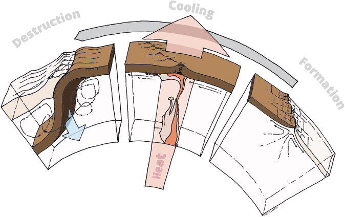
As humans explore the solar system, the Earth emerges with a unique signature: plate tectonics. Even as geoscientists use the plate tectonic framework to interpret the surface of solar system bodies, the Earth remains the only planet with well-defined plate boundaries whose motions and evolution frame nearly all geological phenomena—as recorded in Earth’s crust and imaged in the deep interior—and provide basic controls on Earth’s atmosphere and oceans. Although many aspects of plate tectonic behavior and geometry are clear, there is a lack of fundamental understanding of when plate tectonics developed on the Earth, why on the Earth and not elsewhere, the interconnections with elemental cycling on the Earth, and the processes that explain how it developed (NRC, 2008; Huntington and Klepeis, 2018).
The early stages of Earth’s evolution are deeply tied to planetary formation (Hawkesworth and Brown, 2018; Lock et al., 2018). Critical to the questions of why and how is a more comprehensive definition of what plate tectonics actually is and was (Joel, 2019). Is it today’s plate tectonics world with ridges and one-sided subduction dominated by oceanic plates? Or is plate tectonics any type of lithospheric mobility and recycling? The answer to what also becomes central to when.
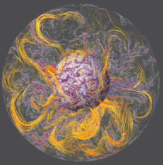
The view today is that plate tectonics and mantle convection are one and the same (Coltice et al., 2019). Plates, particularly oceanic, are the upper thermal boundary layer of the convecting system (see Figure 2-3)—the product of melting and differentiation of the mantle, and the crystallization and cooling of these materials near Earth’s surface. Their distinct dynamic and kinematic behavior arises directly from the intrinsic material properties of rocks. The continuous recycling of plates and the compositional, thermal, and rheological heterogeneity acquired through their life cycle are key to understanding the present-day mantle. This view of what plate tectonics is today has evolved over the past two decades, made possible by advances in seismic imaging and analysis, computation, damage theory, and rheological measurements that have shown the promise of a tightly integrated fluid dynamical view of plates and mantle (Bercovici and Skemer, 2017; Coltice et al., 2019).
The nature of plate tectonics has broad impacts beyond geology and geophysics. It underpins efforts to better understand the physical processes that determine the surface deformation and magmatism
___________________
1 See https://www.nasa.gov/mission_pages/juno/main/index.html (accessed March 23, 2020).
responsible for geohazards, the storage and evolution of elements critical to biological activity and modern society, the evolution of life and biogeochemical cycles, long-term climate change, and the extent of flooding due to present-day sea-level rise.
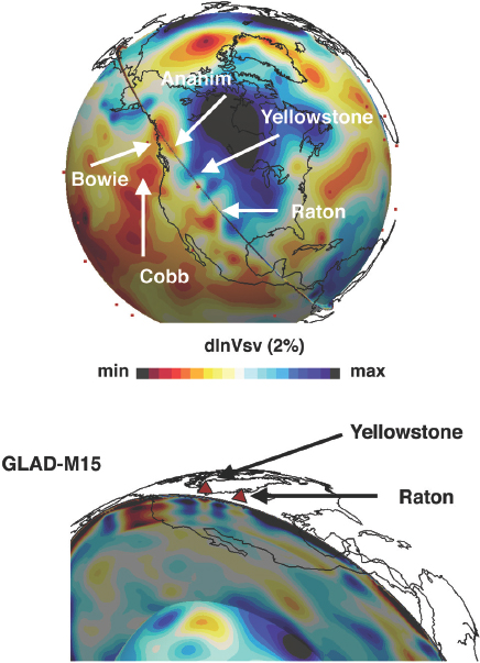
Understanding of plate tectonics with its broader implications is poised for revolutionary progress in the next 10 years. The problem of obtaining enough precise and accurate data to answer the question of when is being transformed by developments in geochemistry (e.g., Hawkesworth et al., 2017), the acquisition of geological records of plate motion (e.g., Holder et al., 2019), and geochronology. The history of plate tectonics is but one of many questions (![]() ) whose answers would be advanced by reaching a community goal (Harrison et al., 2015) of achieving 0.01% precision on dating throughout Earth’s history (see Chapter 3 for more discussion). The questions of how plate tectonics evolved and why on the Earth are also progressing. For example, understanding of the earliest stages of Earth’s evolution, which was dominated by a magma ocean, giant impacts, and likely a vastly different convective mode prior to the onset of plate tectonics, has been expanded by analysis of geochemical properties of Hadean minerals (e.g., Harrison et al., 2017), measurements and simulations of materials at extreme conditions, and models of planetary formation (Kraus et al., 2012; Scipioni et al., 2017). Moreover, advances in fluid dynamics, computation, and characterization of Earth’s material properties now make it possible to simulate the evolution of the mantle–plate system in detail (e.g., Bocher et al., 2018). These geophysical developments leveraged advances in seismic imaging, which have revealed mantle and core structure and illuminated Earth’s subsurface dynamics (see Figure 2-4). The development of new chronometers and novel isotopic systems have continued to open paths of understanding from the age of core formation to elemental chemical exchanges.
) whose answers would be advanced by reaching a community goal (Harrison et al., 2015) of achieving 0.01% precision on dating throughout Earth’s history (see Chapter 3 for more discussion). The questions of how plate tectonics evolved and why on the Earth are also progressing. For example, understanding of the earliest stages of Earth’s evolution, which was dominated by a magma ocean, giant impacts, and likely a vastly different convective mode prior to the onset of plate tectonics, has been expanded by analysis of geochemical properties of Hadean minerals (e.g., Harrison et al., 2017), measurements and simulations of materials at extreme conditions, and models of planetary formation (Kraus et al., 2012; Scipioni et al., 2017). Moreover, advances in fluid dynamics, computation, and characterization of Earth’s material properties now make it possible to simulate the evolution of the mantle–plate system in detail (e.g., Bocher et al., 2018). These geophysical developments leveraged advances in seismic imaging, which have revealed mantle and core structure and illuminated Earth’s subsurface dynamics (see Figure 2-4). The development of new chronometers and novel isotopic systems have continued to open paths of understanding from the age of core formation to elemental chemical exchanges.
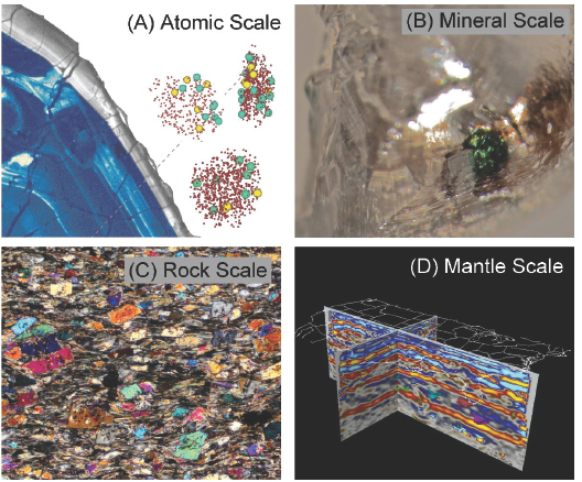
New instruments that can make geochemical and structural observations at fine spatial scales (e.g., individual atoms with transmission electron microscopy and atom probe tomography) and can also recover geochronologic information are good examples of the rapidly accelerating technical capabilities to probe the minerals that preserve the record of plate tectonics in the crust. The measurements they enable will be essential to determining the signatures of plate tectonics in the geological record, from the rise of the first continents to their emergence above sea level. Other emerging fields such as nontraditional stable isotope geochemistry (Teng et al., 2017) are advancing quickly to provide new insights into relevant cosmochemical, geological, and biological processes. Similarly, experimental and computational investigations of material properties at extreme conditions can reveal chemical reactions, measure kinetics, and determine the properties of liquids (Sanloup et al., 2013; Millot et al., 2019). Computational advances also promise much higher-resolution imaging of Earth’s structure and better constraints on dynamical evolution (Bozdağ et al., 2016; Bocher et al., 2018). The combination of material property measurements, imaging, and state-of-the-art physical modeling with data assimilation will be crucial to answering a central question of plate tectonics: How did (and does) subduction initiate?
Facilities and partnerships will be essential to the answers that emerge in the next 10 years. Partnerships that highlight synergies in computation and material characterization include coordination within NSF and between NSF and the National Aeronautics and Space Administration (NASA), the U.S. Department of Energy (DOE), and USGS. Progress in characterizing materials and documenting the history of plate kinematics will depend on continued expansion of data collection, including seismic and geodetic efforts (as anticipated by the SZ4D initiative2 [see Chapter 3]); chemical, geochronological, and paleomagnetic analyses; and geological endeavors such as scientific drilling.
|
3. How are critical elements distributed and cycled in the Earth? |
More than 5,000 known minerals, as well as many yet to be discovered, hold the chemical diversity and history of the Earth. These minerals, along with associated melts and fluids, host and transport critical elements—defined here as elements that are essential for geologic processes such as those that have created suitable conditions for biological activity, and those that provide the raw ingredients for materials essential to the functioning, prosperity, and security of modern society, such as low-carbon or carbon-free energy and elements for electronics, defense, medicine, and advanced manufacturing (see Table 2-1). These elements are concentrated in certain parts of the Earth by processes that geoscientists are beginning to understand on a planetary scale.
The distribution of critical elements in the outermost solid layers of the planet—the continental and oceanic crust and underlying mantle—is determined by the processes that have influenced element cycling between Earth’s interior and surface environments throughout Earth’s history. Dramatic redistribution of critical elements at various times in Earth’s history can be tied to explosions in mineral and biological diversity, the Great Oxidation Event, oceanic anoxic events, and associated changes in atmospheric composition, influencing the history of climate and life through time. The minerals that constitute Earth’s crust and mantle, and consequently the composition of the biosphere and atmosphere, evolved from processing of original materials accreted during the planet’s formation, with
TABLE 2-1 Examples of Critical Elements and Their Significance
| Critical Elements | Significance |
|---|---|
| H, C, N, O, P, S, K, Ca, Fe | Needed for a habitable world (Anbar, 2008) |
| C, S, Fe | Govern redox conditions of the mantle and crust (Armstrong et al., 2019) |
| B, S, halogens (F, Cl, Br, I), noble gases (He, Ne, Ar, Kr, Xe, Rn), transition metals, REEs, Re, Os | Tracers of recycling processes between the crust and mantle (Widom, 2011; Smith et al., 2018) |
| Li, Co, Cu, Cd, REE, U | Low-carbon or carbon-free energy (Sovacool et al., 2020) |
| Be, Mg, Al, Ti, V, Mn, Co, Zn, Zr, Mo, REEs, Hf, platinum group metals, precious metals, U | Materials for modern society (e.g., electronics, defense, medicine, advanced manufacturing) (DOI, 2018) |
___________________
2 See https://www.sz4d.org (accessed December 27, 2019).
additions by comets (Hirschmann, 2016). Earth materials were further transformed by differentiation and crustal formation, the co-evolution of life and plate tectonics (Cox et al., 2018), and catastrophic events such as large-meteorite impacts and volcanic episodes. Ongoing, present-day processes such as melting, re-crystallization, metamorphism, hydrothermal activity, and release or sequestration of gases continue to redistribute critical elements. Some elements are particularly effective tracers of modern and ancient processes of element cycling (see Table 2-1).
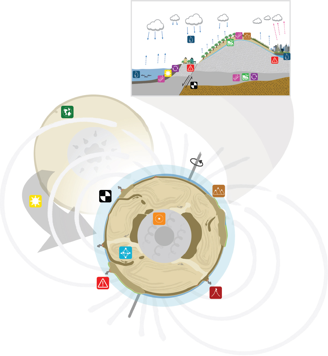
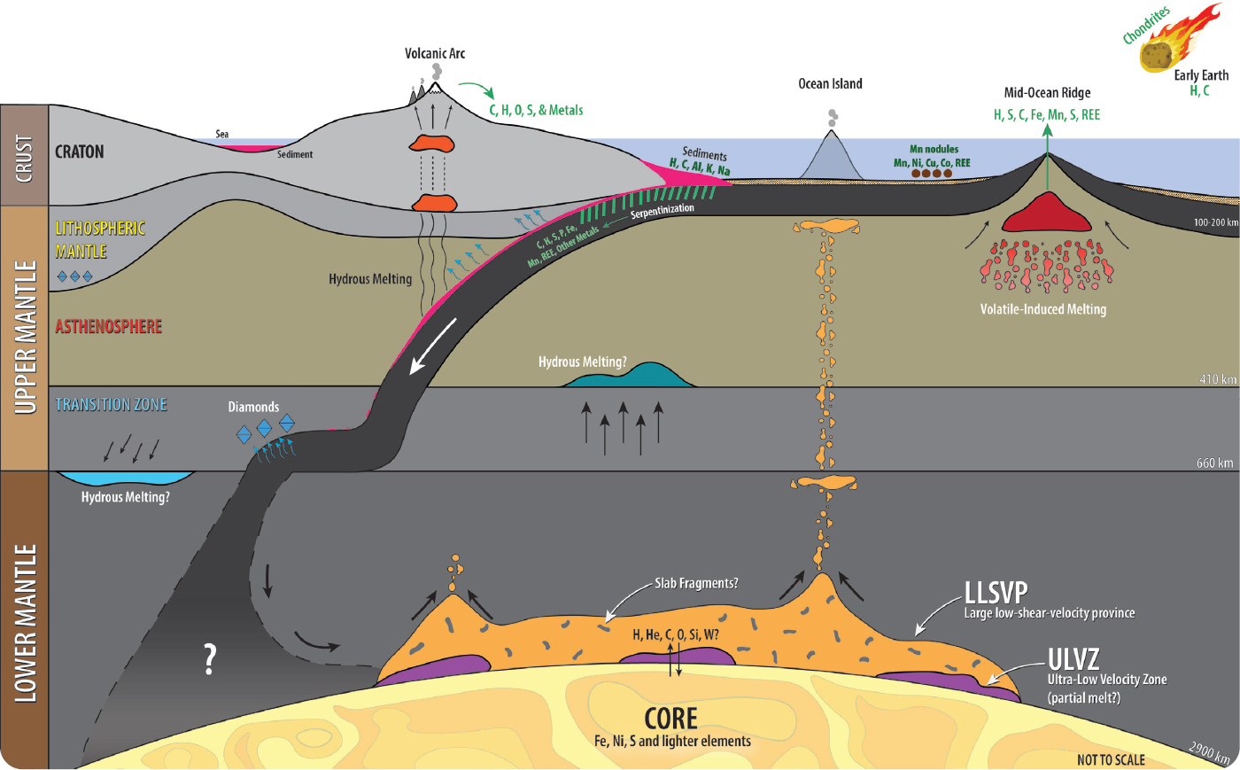
Surface processes are also an important part of the whole-Earth cycling of elements, interacting with deep-seated chemical and physical mechanisms that operate over a range of spatial and time scales. Thus, understanding the distribution of critical elements means mapping the details of a global plumbing system that extends from the core to the clouds (see Figure 2-5).
Carbon, hydrogen, iron, nitrogen, oxygen, phosphorus, and sulfur are among the bio-critical elements that create a habitable world. In the coming years, geoscientists will build on recent advances in understanding the global hydrogen and carbon cycles (Orcutt et al., 2019), with the aim of understanding how the deep sulfur, phosphorous, nitrogen, and other element cycles operate, and how halogens such as fluorine and chlorine and other elements partition into melts and fluids in metamorphic and magmatic systems (e.g., Farquhar and Jackson, 2016; Dalou et al., 2017; Hanyu et al., 2019; Smit et al., 2019).
Critical elements that are required for the materials and energy needs of modern society, such as for low-carbon energy resources, include cobalt, lithium, and rare earth elements (REEs), along with precious metals, manganese, titanium, uranium, vanadium, hafnium, and zinc (see Table 2-1). Elements that act as tracers of recycling processes between the crust and the mantle include boron, halogens, and noble gases, in addition to REEs and other elements (Smith et al., 2018). Critical elements and their compounds, such as water, significantly affect the physical properties of Earth materials, from melting temperature to strength, rheology, and seismic velocity. Multi-valence elements such as iron, sulfur, and carbon govern redox conditions of the mantle and crust (e.g., Evans et al., 2017; Cline et al., 2018). Critical elements vary widely in abundance in different parts of the crust and mantle, but many low-abundance elements have a disproportionately large influence on geological processes and physical properties of Earth materials.
Some elements partition strongly into fluids and melts that move along conduits at many scales, including the vast network of mineral grain boundaries and structures that develop during flow of fluid or melt (see Figure 2-6). Minerals and their accompanying melts and fluids are the dynamic connection between the deep interior and the surface of the planet, and minerals that form at great depth in the Earth provide clues to the evolution of the atmosphere, oceans, and surface. For example, some superdeep diamonds have been found to contain hydrous minerals (Pearson et al., 2014), traces of water-ice (Tschauner et al., 2018), and biogenic carbonate produced at or near Earth’s surface (Li et al., 2019b). Despite this cycling, Earth’s interior retains major chemical heterogeneities, which can be imaged with advanced seismological methods (Wang et al., 2019). For example, some deep-sourced magmas contain hydrogen and helium that have been largely isolated since the segregation of the core (Loewen et al., 2019). The persistence of long-lived chemical reservoirs within the dynamic planet has not yet been adequately explained.
Knowledge of processes that catalyze the most influential chemical reactions in the planet is only beginning to emerge and be incorporated into geodynamic models of Earth’s interior (Li et al., 2019a). For example, controls on the reduction-oxidation (redox) state of different crust and mantle domains are central to planetary evolution. Among other effects, redox reactions of iron-controlled segregation of the core and the oxidation of the mantle help determine the composition of the atmosphere (Armstrong et al., 2019). Interactions among geothermal, hydrologic, geobiological, and geochemical processes at the interface between the subsurface and atmosphere will require more sophisticated, multicomponent reactive transport models (e.g., Li et al., 2017).
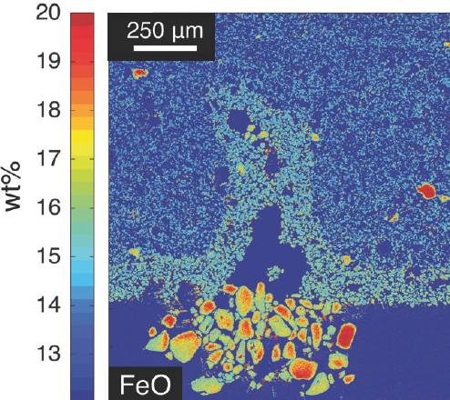
By integrating technological advances in experimental and computational methods with thermodynamic modeling, high-precision micro-analysis of geologic samples, and geophysical data, geoscientists are on the verge of a new understanding of how minerals and fluids react, recycle, and redistribute critical elements from atomic to planetary scales (see Figure 2-7). For example, we can now start to understand the mechanisms and timing underlying the formation and transformation of the crust and the emplacement of large igneous bodies, as well as how these processes have altered climate (Lee et al., 2017), influenced the distribution of
economically significant elements at various stages of Earth’s history, and ultimately determined habitability of the surface.
Because the definition of critical elements is broad, encompassing materials required by modern societies for security, prosperity, and health and for low to carbon-free energy sources, as well as for long time- and spatial-scale planetary processes such as volatile cycling between Earth’s interior and surface (see Table 2-1), a broad range of infrastructure and partnerships is needed to optimize research opportunities. DOE synchrotron radiation facilities are needed to conduct highly specialized geochemical analyses and measurements of physical and mechanical properties of Earth materials under a wide range of physical conditions including variable pressure, temperature, oxygen fugacity, and strain rate (Dera and Weidner, 2016). Rapidly developing capabilities to link geochronology with petrology and geochemistry (Rubatto, 2002; Kohn et al., 2017), and the latest generation of micro- and nano-analysis techniques provide opportunities to determine the pressure–temperature–fluid-deformational evolution of minerals from their formation in deep time to their present exposure at Earth’s surface. Cyberinfrastructure is needed to enhance training and research in data science, develop geochemical and thermodynamic databases, and create new routes of network analysis and machine learning to search for patterns in the time and age of mineral and biogeochemical evolution (Hazen et al., 2019). New partnerships and collaborations involving novel dynamic compression methods (DOE), programs related to critical minerals (USGS), and EAR core disciplinary programs as well as other divisions of GEO (e.g., OCE for processes in the marine realm), combined with infrastructure provided by the Instrumentation and Facilities Program, will be especially valuable in promoting research on critical elements.
|
4. What is an earthquake? |
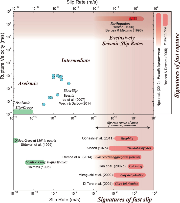
In textbooks and even for most Earth scientists, earthquakes are sudden motions of the Earth caused by rapid slip on planar faults. Recent observations, however, show that earthquake rupture is not simple and that deformation of the Earth occurs over a broad range of spatial and temporal scales, from the seconds and minutes associated with rapid slip to the million year scale of plate tectonics. For example, recent earthquake ruptures have expressed exceptional geometric complexity (Hamling et al., 2017), and dramatic improvements in
monitoring have led to discoveries of a far broader spectrum of slow, transient deformation than represented by ordinary earthquakes (Beroza and Ide, 2011; see Figure 2-8). Increasingly comprehensive geological records of exhumed faults and their surroundings demonstrate that deformation and its localization are multi-faceted and strongly depth dependent (Rowe and Griffith, 2015).
This realization has led Earth scientists to reconsider the very nature of earthquakes and the dynamics that drive them, and to pose the deceptively simple question, “What is an earthquake?” Motions and deformation, regardless of scale, are Earth’s responses to the internal stresses that give rise to plate tectonics, mountains, and topography. We know the form of the equations governing deformation, but not the flow laws that govern the relevant material properties for deformation.
The promise of the coming decade is that advances in characterizing material properties, coupled with high-performance computing to carry out increasingly accurate simulations of crust, lithosphere, and mantle deformation processes, will lead to a more fundamental understanding of the full spectrum of observed deformation. With such an understanding it will be possible to construct a new comprehensive framework, rooted in the forces that drive the system and the material behavior that controls deformation at all relevant scales.
In this new view of the Earth, plate boundaries would not simply be described by their relative motions, but by their origin, nature, complexity, and evolution as fault systems in terms of the convective forces that control them. This view would represent a new comprehensive theory of plate tectonics that features a dynamic, physics-based understanding to supersede the current kinematic, descriptive framework. Plate
tectonics and mantle convection would come to be seen as different manifestations of a single process, in which the Earth deforms in response to stress in predictable ways depending on material properties (Coltice et al., 2019).
This unified theory requires several key components: (1) seismic and geodetic observations that are integrated with fault zone geology to build a comprehensive understanding of deformational response to tectonic stress; (2) integrated field and geochronologic studies to determine slip histories and earthquake recurrence intervals on known faults; (3) field campaigns to determine how much motion is taken up by known and unmapped faults over the time scales relevant to fault systems (and by extension plate boundary) evolution; (4) experiments in rock mechanics and rheology that measure the material properties needed to describe deformation; and (5) the development of dynamical models that can reproduce the spectrum of observed deformations from rapid, slow, and steady slip to plate motions. Such a multi-pronged approach is compelling from a scientific point of view, but also important due to the human consequences of earthquakes.
The combination of fundamental science and societal relevance has been a theme of recent and proposed geoscience community plans (Williams et al., 2010; Davis et al., 2016; McGuire et al., 2017; Bebout et al., 2018; Huntington and Klepeis, 2018). These projects and proposals aim not only at imaging and measuring the Earth, but also at a predictive understanding of the underlying physical processes and their consequences, with obvious implications for earthquakes as natural hazards. They recognize that the variety of processes over the full range of time scales relevant to understanding deformation in the Earth, from earthquakes to plate motions, require synergistic interagency, national, and international partnerships. The breadth of processes also motivates a diversity of infrastructure—ranging from material characterization to seismometers, from instrument-based facilities to cyber- and personnel infrastructure—as well as controlled fluid injection experiments in which a fault is drilled and instrumented in advance of an induced earthquake.
|
5. What drives volcanism? |
Volcanic eruptions are among the most spectacular and complex manifestations of the Earth system (see Figure 2-9a). How can their onset, duration, magnitude, and intensity be assessed and anticipated? Today, volcano science is poised to supply answers via physics-based models for all key processes driving eruptions, taking advantage of a wealth of data from eruption observations on fine temporal and spatial scales, and the emerging ability to process data extremely rapidly (NASEM, 2017). In addition, new time-sensitive geophysical imaging techniques and micro-scale geochemical clocks provide unmatched information about the speed of rising magma in the crust and mantle, and how the geometries of storage regions (reservoirs) and transport pathways (conduits) of volcanoes evolve and influence eruptions. Geoscientists are on the cusp of being able to use these approaches during eruptions to provide urgently needed advice to response agencies in near-real time.
Volcanoes are also a key connector within the Earth, unique in how they interact with other parts of the Earth system (NASEM, 2017). Eruption and emplacement of large igneous provinces, on a scale orders of magnitude larger than anything seen historically, are associated with global warming and ocean acidification from massive increases in atmospheric carbon dioxide, as well as global dimming and catastrophic volcanic winters. Such events are temporally linked with some of the most significant mass extinctions in the geological record (e.g., Burgess et al., 2017), highlighting the arguably outsized role of volcanoes and their associated intrusions in the history of life (Rampino and Self, 2015). Smaller but nevertheless catastrophic eruptions have occurred on active systems such as Yellowstone Caldera. Eruptions from caldera systems are about two orders of magnitude more common than large igneous provinces, and at least one or two orders of magnitude larger than historic eruptions. These catastrophic eruptions are very rare events but are critical to understand because their impacts were immense, and, in the modern world, would be horrific (see Figure 2-9b). Even smaller, historical eruptions profoundly change landscapes for decades or centuries and can have global impacts that affect society (see Figure 2-9b). For instance, aerosol cooling effects from eruptions such as Pinatubo in 1991 have had demonstrable global impact for weeks to years (Timmreck, 2012). An emerging challenge is to understand the feedbacks between volcanoes and climate change in the 21st century and beyond. Volcanologists look to understand the fundamental processes of magma generation, ascent, and eruption, and thereby establish how mechanisms and impacts of magmatism, and linked feedback cycles among the atmosphere, hydrosphere, biosphere, and geosphere, scale up by more
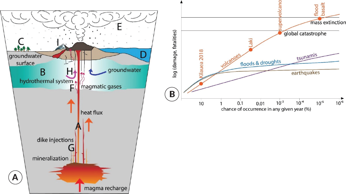
than three orders of magnitude to apply to these very large infrequent events.
The magnitude of maximum potential impacts from volcanoes can be global, compared to more localized hazards like extreme weather, landslides, and flooding (see Figure 2-9b). Yet, in understanding what drives volcanism, it is essential to recognize that eruptions do not simply modify their surroundings; they are also strongly influenced by them. Tectonics control the composition and amount of magma that is generated and transported through volcanoes. Large earthquakes are postulated to increase greatly the probability of eruptions at nearby volcanoes (Manga and Brodsky, 2006). There is clear evidence that changes in climate influence the behavior of volcanoes (e.g., Watt et al., 2013). Environmental water surrounding or overlying a volcano has profound effects on eruption processes on time scales that range from microseconds to hours, and spatial scales of submillimeters to kilometers (see Figure 2-9a). Volcanoes respond to deformation associated with seasonal and climatic cycles, including the behavior of glaciers (Rawson et al., 2016), as well as to orbitally paced changes in sea level that in turn affect eruptive rate (Conrad, 2015).
Major eruptions are rare among natural hazards in that they often offer weeks to months of warning in the form of seismicity, deformation, and outgassing that precede the onset of dangerous eruption. To turn these warnings into accurate forecasts, however, requires mapping the patterns of repose, unrest, precursors, and eruptions for the entire life span of many individual volcanoes. Currently, full histories are known for very few magmatic systems and individual volcanoes, so generalization is difficult. A goal for the next decade is to augment those histories—particularly for low-frequency but extremely high-impact events—using time series of volcanic products in sedimentary archives such as continuous cores and outcrops as well as ice cores. These contain volcanic relics of distal ashes, crypto-tephras, and chemical species, such as sulfate, chlorine, and mercury, that provide information about the frequency of eruptions beyond historical records. Scientific coring and drilling of volcanoes and their feeder systems support the understanding of the mechanisms of eruptions through real-time monitoring (e.g., Sakuma et al., 2008) and longer temporal records (e.g., Stolper et al., 2009).
The publication of Volcanic Eruptions and Their Repose, Unrest, Precursors, and Timing (NASEM, 2017) followed by the 2018 Kīlauea eruption have united volcanologists with a vision to create a coordinated community involving academia, USGS, and other
government agencies. This diverse community includes geodesists, seismologists, gas and rock chemists, physical volcanologists, remote sensing specialists, numerical and analog modelers, sedimentologists, geochronologists, and experimental petrologists. An unprecedented increase in new technologies is now available to observe volcanic systems and transform the understanding of underpinning processes. New progress will require developing novel models leveraged by machine learning techniques, artificial intelligence, and collaboration with computer engineers, mathematicians, and statisticians. These developments bring with them the infrastructural and computational challenges of rapid acquisition, processing, and interpretation of large amounts of data on short time scales. Many key advances in understanding magmatic and volcanic processes will derive from data that can only be obtained during hazard events (a key component of the Community Network for Volcanic Eruption Response Research Coordination Network [CONVERSE], part of the SZ4D initiative); in turn, new advances in hazard forecasting will critically depend on better understanding of the physics of magmatic and volcanic processes.
|
6. What are the causes and consequences of topographic change? |
Great progress over the past two decades has been made in linking climate, tectonics, and erosion processes to understand how they shape and are dynamically influenced by Earth’s surface topography. This progress has brought into focus key scientific questions concerning the role of rock mechanical properties, short-term actors such as storms, and the rheology and dynamics of Earth’s interior in landscape evolution and the co-evolution of landscapes with the atmosphere, cryosphere, sea level, and life. New technology for measuring topography over geologic to human time scales now makes it possible to address these key questions, and their implications for urgent societal challenges related to geologic hazards, resources, and climate change (NRC, 2015; Davis et al., 2016; McGuire et al., 2017; Barnhart et al., 2018; Huntington and Klepeis, 2018; NASEM, 2018).
Topography is sensitive to processes that operate above, on, and below Earth’s surface at many scales. Mantle dynamics and plate boundary evolution drive the surface morphology of continents over time scales of millions to hundreds of millions of years and spatial scales of tens to thousands of kilometers as erosion actively removes mass. Actors like earthquakes, volcanic eruptions, storms, and glaciers affect regional to local (i.e., hillslope-scale) topography on time scales of minutes to millennia. Topography itself influences these processes and their interactions by affecting global and local climate, lithospheric stresses, and erosion processes. Topography is also the fundamental feature of the landscapes on which we live. Quantifying topographic change is therefore crucial to advance many areas of geoscience—from understanding Earth-system interactions over geologic time, to predicting landslides, ecosystem gradients, and the distribution of freshwater and soil resources in the coming decades.
Many newly recognized connections among different parts of the Earth system are expressed in topographic form and change. Such connections involve phenomena as diverse as the interactions of mantle dynamics, surface processes, ice-sheet changes, and sea level (e.g., Flament, 2014; Heller and Liu, 2016; Austermann et al., 2017; Whitehouse et al., 2019); and the co-evolution of landscapes and life (e.g., Badgley et al., 2017; Fremier et al., 2018). They are manifest in links between the geologic history of near-surface deformation and newly imaged deep lithosphere and mantle structures (Wu et al., 2016); and in feedbacks among rock strength, lithospheric stresses, biogeochemical cycles, climate, and physical and chemical erosion (e.g., Riebe et al., 2017). These are just a few examples of the many promising frontiers created by recent advances in our ability to measure and model topographic change on many time scales.
At the same time, the need to understand how topography and topographic change impact human society through geologic hazards and the creation or destruction of natural resources and habitats is more urgent than ever (Davis et al., 2016; NASEM, 2018). For instance, there is a critical need to quantify how topography will influence ecosystem and hydrologic change in a changing climate. In turn, we need to understand how land use, ecosystem, and water cycle changes alter topography. Topography and topographic change also affect the risk to lives and property posed by earthquakes, landslides, floods, mudflows, eruptions, and tsunamis. Observations and process-based understanding of topographic change have great potential to provide essential insight into the processes that underlie these hazards.
Technological advances set the stage for breakthroughs in understanding the causes and consequences of topographic change within the linked system encompassing the deep Earth, surface processes, climate,
and the biosphere. For example, the rapid increase in lidar, photogrammetry, InSAR, and drone-based datasets has revolutionized our ability to quantify changes in modern topography (e.g., James and Robson, 2012; Roering et al., 2013; Deng et al., 2019; see Figure 2-10). In the next decade, a community goal is to reach submeter resolution in modern topography for much of the globe (Davis et al., 2016). Repeated measurements could capture responses to earthquakes, weather events, volcanic unrest, and human activity. Visualizations created from 34 years of Landsat imagery3 are already transforming how we see the Earth, especially surface processes. River meandering, glacier dynamics, coastline changes, landslide events, and other large-scale surface processes can be observed in ways never before possible, providing new understanding and raising new questions (Schwenk et al., 2017; Dirscherl et al., 2020; Nienhuis et al., 2020).
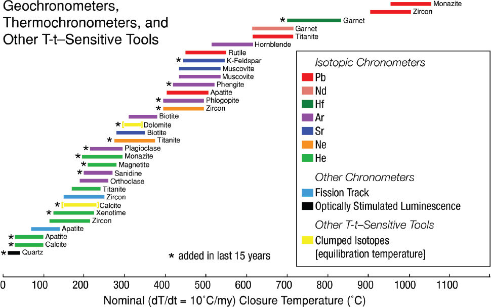
Our ability to measure topographic change on geologic time scales has also seen recent advances and is poised to improve dramatically in the near future, creating unprecedented opportunity for progress. New thermochronology approaches (see Figure 2-11) provide opportunities to reconstruct the exhumation of rocks from the deep crust to the surface (Huntington and Klepeis, 2018), enabling estimates of the timing and rates of erosion and relief formation across the globe over thousand- to million-year time scales (e.g., Champagnac et al., 2014; Harrison et al., 2015). Refined paleoaltimetry methods, including use of hydrogen isotope archives in volcanic ash and carbonate clumped isotope thermometry, now provide data on topographic change at the scale of watersheds and mountain ranges over geologic time (e.g., Garzione et al., 2017), and are being integrated with climate models and geologic observations to provide 0.5-km-scale paleoelevation estimates (Cassel et al., 2018). Such approaches enable us to explore the significance of topographic change in deep time, for instance connections between plateau uplift,
___________________
3 See https://earthengine.google.com/timelapse (accessed March 31, 2020).
silicate and carbonate weathering, seawater chemistry, and atmospheric circulation and composition (e.g., Farnsworth et al., 2019), and potential links between the evolution of mountainous topography and species richness (Antonelli et al., 2018).
Several emerging challenges must be addressed to realize the opportunities that arise from recent conceptual and technological advances. Improved estimates of the timing and rates of surface uplift, subsidence, and erosion/deposition are needed to directly link near-surface deformation and resulting topographic change with the rheology and dynamics of Earth’s interior. Illuminating rheology and dynamics through integration of seismological observations and dynamical models of mantle flow and lithospheric deformation will be critical for understanding the strength of such links—and the role of Earth’s interior dynamics in present-day sea level and future sea-level predictions. Observations and theory are also needed to quantitatively define the role of chemical and mechanical properties of rocks, and the role of geologically short-term actors such as storms, earthquakes, and rapid glacial retreat in surface processes and landscape evolution. Coupling detailed landscape models to large-scale mantle models (e.g., Braun et al., 2013) remains a challenge owing to their differing spatial and temporal scales and uncertainties in Earth-material properties (e.g., rheology). The role of topography and topographic change in land–atmosphere feedbacks (see Figure 2-12), land–ice interactions, coastal and dryland processes, habitat creation, and ecosystem structure in a changing climate is just beginning to be explored, with important implications for Earth’s habitability over geologic time and in the next century.
Focused attention on these challenges over the next decade promises new insights into the interactions of Earth’s surface and deep interior, and into the co-evolution of Earth’s solid, fluid, and living components. Progress will require high-resolution repeat measurements of modern surface topography and vegetation cover and cyberinfrastructure to support open access to, and rapid processing and analysis of, imagery and point cloud data; long-term observations of modern weather, hydrology, and geochemistry of surface waters, soils, and sediments; and new records of past climate, elevation, relief, deformation, weathering,

erosion, deposition, and ecosystem change through geologic time. Partnerships across GEO and with NASA, and new and refined geochronologic and stable isotopic approaches, will be central to developing these datasets and records. Geophysical methods (e.g., Aster et al., 2015) present exciting opportunities to quantify Earth’s structure and rock mechanical properties (e.g., erodibility, rheology) at depths ranging from meters to thousands of kilometers. Integration of such diverse datasets with high-resolution computer models of landscape evolution, mantle dynamics, and climate is key to enabling process-based understanding of the causes and consequences of topographic change.
|
7. How does the critical zone influence climate? |
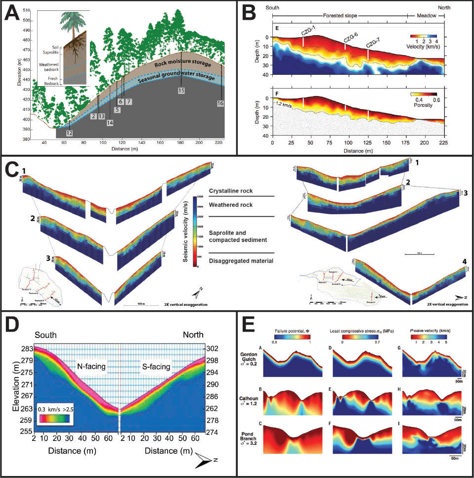
The critical zone is the reactive skin of the terrestrial Earth, extending from the top of the vegetation through the soil and down to fresh bedrock and the bottom of actively cycling groundwater (NRC, 2001; Sullivan et al., 2017; see Figure 2-13). Critical zone properties are driven by the interactions of tectonics, climate, topography, weathering, erosion, and life that produce, over geologic time scales, a permeable, water-storing, chemically reactive environment out of dense bedrock (e.g., Riebe et al., 2017). This frontier area of investigation, which is so important to life and Earth’s processes, has inspired research programs focused on the critical zone to be instituted in the United States and throughout the world (Richardson, 2017)—enabling pioneering studies of water, nutrient, and carbon cycles, and connections between vegetation and deep subsurface processes (e.g., Brantley et al., 2017). Scientific drilling and geophysical surveys have now revealed systematic variation in critical zone structure with hillslope topography (see Figure 2-13) and motivated development of quantitative models for these observed relationships (Riebe et al., 2017).
While it is widely understood that the structure and function of the critical zone is influenced by climate, only recently has the community begun to identify the ways and extent to which the critical zone also exerts influence on climate (Fan et al., 2019). Because the structure and reactivity of the critical zone influences moisture, groundwater, energy, and gas exchanges between the land and atmosphere, it exerts a key role in
modulating atmospheric concentrations of greenhouse gases (particularly water vapor and carbon dioxide) and, therefore, temperature. This insight is particularly timely because it occurs synchronously with a growing realization in climate science that the land is not merely the bottom boundary condition for the atmosphere, but an integral part of the climate system. The critical zone stores water, providing moisture to vegetation, recharge to groundwater, and runoff to streams. While Earth system models include soil moisture exchange with the atmosphere via evaporation and transpiration, critical zone research reveals that moisture stored in weathered bedrock below the soil can be a significant source of transpired water—a missing reservoir in climate models (e.g., Fan et al., 2019). The critical zone is also where the terrestrial carbon storages exchange with the atmosphere, and growing evidence indicates that carbon dynamics extend deep into the critical zone. Process-based understanding and conceptual models of how critical zone structure and composition control coupled water, energy, carbon, and nutrient cycles are needed to quantify the role of the critical zone in Earth’s climate system.
On longer time scales, critical zone development influences how physical erosion rates and chemical reactions that drive carbon dioxide drawdown are linked (e.g., Schachtman et al., 2019). Tectonism forces uplift and influences erosion rates, while channel incision drains landscapes—together, these actions strongly influence the physical and geochemical evolution of the critical zone. Throughout the geologic past, critical zone properties have likely changed with the emergence of life, land plants, and animals, and the physical and chemical consequences that followed. Exploring possible ancient critical zone properties and processes is important to understanding the evolution of Earth’s climate and its biogeochemical and sedimentary record.
Looking toward our future in the Anthropocene, the critical zone is where all plants get water, where streamflow is sourced, and where our subsurface water supply is temporarily stored. It is where significant change will occur due to ongoing agricultural and other land-use activities, the warming of the Arctic, and the drying of semi-arid regions. The hydrologic and ecological consequences of these changes and the anticipated increased frequency and duration of extreme droughts and storms will be mediated by critical zone properties, and the deep, poorly known component of the critical zone may play an important role. Feedbacks between critical zone and atmospheric processes will drive regional to global climate conditions. For example, the progressive spatial shifting of vegetation and agricultural zones with warming will depend on moisture storage characteristics set by critical zone properties. Changes in vegetation and land use will in turn feed back on climate processes by altering albedo, transpiration rates, and atmospheric humidity and temperature.
Process studies of how the deep critical zone will influence the co-evolution of vegetation, water resources, and climate will be essential for quantifying feedbacks. These studies can take advantage of advances in field instrumentation for monitoring the water budget (including soil moisture, rock moisture, groundwater, transpiration, humidity, precipitation, and runoff) and gas dynamics (including CO2 exchange). Repeat terrestrial and airborne lidar surveys enable documentation of vegetation structure, and hyperspectral surveys detect stress states. Natural isotopic tracers can be used to track water sources for vegetation and residence time of stored waters. Remote area studies now rely on solar power, rugged data loggers, and radio or cell phone connections for near-real-time observations. Sustained long-term observations to document changes at a site are essential. The field locations in the NSF-supported National Ecological Observatory Network program and the NSF Long Term Ecological Research Sites may provide settings for some critical zone studies. The NSF Critical Zone Observatories have created a benchmark dataset for the period 2007 to 2020. The Critical Zone Collaborative Network may lead to additional benchmark datasets for the period 2020 to 2025. Partnerships with various federal agencies ranging from DOE to the U.S. Forest Service are under way and can be expanded. The long-term satellite observations by Landsat will play an important role in tracking surface change, while large-scale moisture change at depth (GRACE mission) and in shallow soil (SMAP mission) are recorded globally.
A challenge to including the critical zone in Earth system models is the quantification of critical zone properties over regional, continental, and global scales. The properties (e.g., depth, porosity, and carbon content) of the critical zone below the soil are essentially unknown except for a few intensively studied sites. These few studies suggest that critical zone properties may vary systematically with topography (e.g., see Figure 2-13). Motivated by discoveries at the U.S. Critical Zone Observatories, several theories suggest predictable relationships between topography, lithology, climate, uplift and erosion rates, and the depth and degree
of weathering in the critical zone (e.g., Riebe et al., 2017; Anderson et al., 2019; Harman and Cosans, 2019). A long-term campaign to document for the first time the critical zone at the continental scale is needed. Aerial lidar surveys can rapidly generate high-resolution maps, and many areas have been flown already. Advances in ground and aerial geophysical technology and quantitative theory for predicting critical zone properties should accelerate data collection and map generation. Such a campaign could partner with USGS and state geological surveys. In addition, partnering with the National Center for Atmospheric Research to develop and refine global land models would benefit critical zone science.
Finally, to tackle the problem of the influence of the critical zone on climate, Earth scientists, biologists, climate scientists, and social scientists will need to work together, building collaborations across several NSF directorates, including Geosciences, Biological Sciences, and Social, Behavioral and Economic Sciences (SBE).
|
8. What does Earth’s past reveal about the dynamics of the climate system? |
The more that is known about Earth’s past, the better that future changes can be anticipated (NRC, 2011). We now live in the Anthropocene, where humans have become geologic agents (Crutzen, 2006). Changes that required thousands to millions of years to occur in the geologic past now occur on human time scales. Carbon that was buried and transformed over tens to hundreds of million years has been put back into the atmosphere over the time scale of a century. During the deglaciation from the last ice age, it took about 6,000 years to achieve a ~80 ppm rise in atmospheric carbon dioxide concentration. An equivalent magnitude of increase in atmospheric carbon dioxide has occurred over the past ~50 years, within the lifetime of a person born in the 1970s.
Earth scientists are integral to providing deep and compelling scientific context to the challenges faced by human society in the face of rapidly increasing rates and magnitudes of climate and environmental change. Evidence of both long-term and rapid environmental change in Earth’s history—from the ancient past to the present—provides key baselines for comparison to modern change, helps to elucidate Earth system dynamics (climate forcings, feedbacks, responses, and thresholds), and plays a critical role in the calibration of physical models that are used to project future scenarios. While rapid, modern environmental changes have been observed from the top of the atmosphere to the depths of the oceans, longer records and observations outside of human experience are needed to accurately infer the impacts of ongoing change. At the same time, Earth science is a critical lens through which to study recent and ongoing changes, particularly in transdisciplinary partnerships to address issues such as geohealth, disaster risk, or urban regeneration and development (Harman et al., 2015; Klenk et al., 2015).
Society is already experiencing major impacts from climate and environmental changes, such as extreme temperatures and weather; sea-level rise; droughts and fires; effects on water quantity, quality, and availability; intensifying storms and inland flooding; and melting of permafrost and ice in polar regions (USGCRP, 2017, 2018; IPCC, 2019). Such impacts, including the intersection of coupled human and natural systems, will be defining issues for the 21st century, influencing everything from agriculture to defense and national security. To this end, continued and focused research on the interactions of Earth systems processes with climate and environmental change carries a particular urgency in the context of accelerating rates of change on human time scales.
There is still much to be learned about Earth’s climate dynamics considering continuing progress in the accuracy and precision of paleoclimate proxies and associated geochronologic data. Here we highlight several areas in which Earth scientists are poised to make advances in the dynamics of climate and environmental change. One of those stems from the increasing capabilities of climate and Earth system modeling coupled with a greater potential for increased temporal and spatial resolution offered by paleoclimate proxies in the geologic record. These advances could enable research relevant to regions that are particularly vulnerable to rapid and/or sustained changes, for example coastal zones, where sea-level rise and subsidence contribute to more frequent flooding (Sweet et al., 2019).
As another example, high latitudes are undergoing rapid transformations as temperatures rise and as losses accumulate in the extent of land ice, sea ice, and permafrost (Plaza et al., 2019). While recent research has made great strides in accounting for the storage and transfer of carbon in this environment, there are still unresolved questions about the processes, such as permafrost melting and changes in microbial communities, that govern carbon storage and fluxes. Additionally, climate models tend to underestimate the magnitude of polar amplification (the higher rate of temperature rise in polar versus temperate and tropical regions). Paleoclimate archives and models are integral to addressing this deficiency and will be key to generating more confident projections in rates of environmental change at high latitudes. Likewise, targeted studies on past and present dynamics of polar ice sheet retreat and the global consequences on land and ocean of reduced sea ice and polar ice are critical to advancing our ability to project changes and adapt to them.
Emerging cyberinfrastructure that archives and analyzes paleoclimate datasets can now be leveraged to address fundamental questions about climate dynamics, thereby addressing long-standing discrepancies between paleoclimate data and models. Merging the knowledge base held in paleoclimate records collected on land and those from the ocean (currently not well integrated due to conceptual and institutional barriers) has the potential to advance the fundamental science on how the integrated climate system works.
Improved capacity to conduct continental scientific drilling projects or those that cross the land–sea
interface could facilitate the development of targeted field programs to recover longer, continuous records of climate variability and/or to increase the spatial and temporal density of observations. Such undertakings will help to address key gaps in existing datasets and to address questions that require longer, more continuous records such as those showing how climate and environmental change connects to other Earth system processes such as tectonics, solid Earth, natural resources, and biotic and landscape evolution. Potential partners in the analysis of paleoclimate include AGS, OCE, NASA, and USGS. Additionally, partnerships with social science (such as research within SBE) can help effectively translate and communicate climate information to the public.
|
9. How is Earth’s water cycle changing? |
The water cycle is necessary for all terrestrial life, and now there is increased urgency to understand changes in the water cycle due to the influence of people and climate change. Terrestrial reservoirs of water throughout the world, particularly groundwater aquifers and the vadose zone, emerged under the influence of dynamics in climate and tectonics over thousands to millions of years. Human societies depend on these reservoirs for both water supply and disposal of wastewater (e.g., water co-produced through enhanced recovery of hydrocarbons). Earth science has a particularly critical role in advancing fundamental knowledge of the water cycle and how it integrates with other physical, biological, and chemical processes in the Earth system (NRC, 2012; NASEM, 2018).
Impacts of climate change on the water cycle and the associated ramifications for civilization motivate much of contemporary hydrology. Of particular interest are the ways in which climate change will affect the nature and frequency of extreme events like droughts, floods, and fires, and the concomitant impacts on human populations. Increased availability of open-source models and computing resources is enhancing applications at larger spatiotemporal scales (Wood et al., 2011; Bierkens et al., 2015). Specifically, the coming decade will see significant advances in integrated and more realistic modeling of hydrologic systems from aquifer to atmosphere (Fan et al., 2019). Because groundwater movement is an integral part of the water cycle, water fluxes across the land surface and between the shallow subsurface soils and deeper aquifers need better quantification. At the same time, there is a significant drive toward improved integration of hydrologic and reactive transport models for biogeochemical applications at watershed or larger scales (Dwivedi et al., 2018; Li, 2019). Methodological advances in data fusion and assimilation, including machine learning, will be key in jointly leveraging models and data.
There is also growing recognition of the inseparability of the water cycle and human activity (Sivapalan et al., 2014; Sarojini et al., 2016). The dynamic integration of hydrologic and human systems is therefore increasingly important in hydrologic modeling (NRC, 2012; Farhadi et al., 2016). Substantial water will be required for future food and energy production, but it is unclear whether water availability can meet the demand (D’Odorico et al., 2018). Key gaps in modeling capabilities need to be addressed for both scientific and societal benefit (Givens et al., 2018; Lesmes et al., 2019).
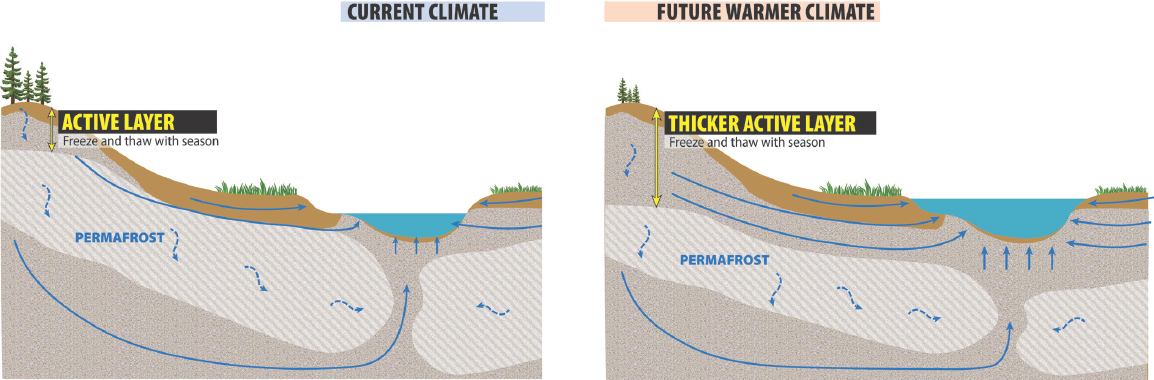
Few geographic frontiers challenge the hydrologic science enterprise like the rapidly changing high-latitude and high-altitude regions. Here there are compelling scientific and societal drivers for understanding the response of the water cycle to Earth’s diminishing cryosphere (Williams et al., 2012; IPCC, 2019). Cryosphere loss, for example from melting glaciers, may increase water storage in other terrestrial reservoirs (Liljedahl et al., 2017; Somers et al., 2019). Thawing permafrost invigorates surface water and groundwater exchange (Walvoord and Kurylyk, 2016; Evans and Ge, 2017), but the long-term impact of cryosphere changes on the water cycle has only begun to be explored (see Figure 2-14). Little is known about how hydrologic properties of permafrost vary spatially and temporally and how water and biogeochemical fluxes change in thawing permafrost regions.
New technologies for measuring hydrologic storages and fluxes have proliferated during the past decade. New geophysical methods reveal the influence of precipitation and transpiration on subsurface water flow (Voytek et al., 2019). Geodetic measurements of snow water and soil moisture content are increasingly more finely resolved (Larson et al., 2008; McCreight et al., 2014; Koch et al., 2019). Advances in the technology of sensors, microcontrollers, and wireless communication will continue to drive innovation in observing hydrologic systems. Observations from space will be increasingly vital for quantifying volumetric and temporal changes of different parts of the water cycle. Improved remote characterization of subsurface hydrologic dynamics has aided the study of hydrologic systems at expanded spatial and depth scales. Insights
from NASA’s GRACE satellite have helped the community identify discrepancies between model-derived and space-based observations of continental water storage trends, potentially pointing to shortcomings in model process representation and climate forcings (Scanlon et al., 2018). In the previous decade, various space agencies launched satellites focused on precipitation (GPM), soil moisture (SMAP), and groundwater (GRACE-FO). Forthcoming and potential satellites will capture surface water (SWOT), groundwater (GRACE2), and snow (Deeb et al., 2017).
Because of its complexity and importance, the water cycle is an area where partnerships can support NSF’s mission to advance the fundamental state of knowledge. Of particular interest are decadal-scale processes integrating climate, shallow oceans, global water resources, and people. New observational data are being produced at an extraordinary pace by NASA’s Earth-observing satellites, measuring changes in glaciers and snowpacks, land use and land cover, sea level, and soil moisture. EAR and NASA could consider a collaborative research initiative, with the possible inclusion of mission agencies focused on applications and societal needs, to quantify changes in freshwater storage and to understand the dynamics of water fluxes through the cryosphere and across the land surface. Additional natural partners of EAR are federal agencies such as DOE and USGS, as well as other directorates and programs within NSF that have interests in water cycle–related processes (e.g., SBE, Directorate for Engineering [ENG], Division of Environmental Biology in the Directorate for Biological Sciences, GEO’s Office of Polar Programs, and the Intelligent Systems and other divisions within the NSF Directorate for Computer and Information Science and Engineering).
|
10. How do biogeochemical cycles evolve? |
To date, the Earth is the only known planet with an active biosphere. This biosphere has evolved and interacted with the chemical makeup of Earth’s surface for billions of years. Biological processes that cycle carbon, oxygen, nitrogen, sulfur, and other elements and influence the global chemistry and mineral diversity of Earth’s surface include photosynthesis, microbially catalyzed weathering and mineral formation, and the production of biogenic greenhouse gases such as carbon dioxide and methane (see Figure 2-15). The next decade will bring advances in the mechanistic understanding of biological contributions to these biogeochemical cycles and the history of the Earth as a habitable planet. These advances will include the ability to identify genes, metabolic products, organismal groups, and interactions involved in different cycles (NRC, 2012); to track the evolution of relevant pathways using molecular methods; to quantify the influence of biology on the current climate; and to recognize the role of biological processes in the formation and weathering of rocks and minerals, the cycling of carbon, and the composition of the atmosphere (e.g., NRC, 2001; Derry et al., 2005; Azam and Malfatti, 2007; Quirk et al., 2012; Lyons et al., 2014).
Since the beginning of geobiology, reconstructions of the biogeochemical record have been grounded in environmental chemistry, mineralogy, geochronology, microbiology, stratigraphy, and sedimentology (e.g., Baas Becking, 1934; Cloud, 1965, 1968; see Figure 2-16). Major conceptual and methodological developments in the past two decades have mapped geological and geochemical processes onto the astounding and previously unappreciated microbial and metabolic diversity and activity in oceans, sediments, soils, and extreme environments (e.g., Karner et al., 2001; NRC, 2001, 2012; Nesme et al., 2016). These developments include data science, analysis of assemblages of genes and proteins of entire species and ecological communities, molecular microbiology, geochronology, geochemistry, and molecular clocks and molecular phylogenetics more broadly.
Because life can colonize a wide range of environments, the study of any aspect of Earth’s surface chemistry, including critical elements, processes in the critical zone, the water cycle, and the sedimentary record, needs to account for microbial metabolisms that can produce or consume minerals (Hazen et al., 2019), greenhouse gases, and organic molecules. Currently, large uncertainties related to the nature and magnitude of biological feedbacks limit predictive capabilities of climate and geochemical models (NRC, 2012). Progress in cultivation and in molecular and genomic analysis has begun to reveal the metabolism and biogeochemical roles of environmentally common microbial groups (e.g., Boetius et al., 2000; Johnson et al., 2006; Sim et al., 2011). Challenges today and in the next decade will include relating the diversity of microbial communities,
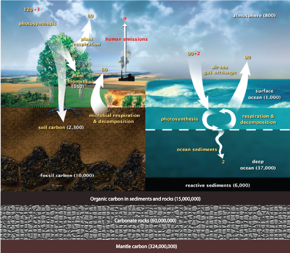
genes, and enzymes, rather than species alone, to the community function, resilience, and geochemical rates of processes.
The convergence of geobiology with materials science, geochemistry, and environmental science is key to commercial applications (e.g., Ehrlich, 1997), bioremediation efforts, the formation of economically important minerals, the environmental stability of toxins or pollutants, and the production of antimicrobial compounds and nanomaterials (NRC, 2012; Boyd et al., 2019). A particularly pressing question concerns the potential impact of biota in all Earth surface habitats on global climate change. On short time scales, the question of geohealth is exemplified by the need to predict responses of modern microbial systems that emit greenhouse gases such as methane or nitrous oxide to human-induced changes such as the thawing of permafrost or agricultural practices (e.g., Richardson et al., 2009; Thomson et al., 2012; Drake et al., 2015; Johnston et al., 2019) and understand the transmission of pathogens in and across natural systems. Future agricultural and industrial developments will also need to consider the microbial cycling of nutrients in soils and marine sediments, transformations of economically important minerals, and the ability to concentrate critical elements.
Evidence of different redox, climatic, chemical, and biological regimes in Earth’s sedimentary rocks invites questions about the drivers and feedbacks that influence the long-term evolution of Earth’s habitability. Numerous major biogeochemical and climate transitions occurred over the past 4 billion years, such as the Great Oxidation Event, the Paleoproterozoic and Neoproterozoic Snowball Earth glaciations, ocean anoxic events and, possibly, metabolic innovations that led to mass extinctions (e.g., Luo et al., 2016; Gumsley et al., 2017; Rothman, 2019). The greatest of these transitions, the Great Oxidation Event, was predicated on the evolution of oxygenic photosynthesis (see Figure 2-16), a metabolism that produced molecular oxygen, stimulated subsequent biogeochemical evolution, and ushered complex life, including humans. Advances in isotope geochemistry tell us that Earth’s atmosphere became oxygenated around 2.4 to 2.3 billion years ago (Farquhar et al., 2000), but when exactly this metabolism evolved and how and why Earth’s surface and atmosphere became oxidized remains unresolved. The ever-increasing knowledge of gene functions and the availability of sequenced genomes, coupled with the microbial fossil record, contribute to the growing field of molecular clock analyses. These analyses are beginning to constrain the events in the early evolution of primary producers and other organisms, the delay between the evolution of oxygenic photosynthesis and the oxygenation of Earth’s atmosphere, and the subsequent interactions among the cycles of oxygen, carbon, sulfur, and other elements (e.g., Sánchez-Baracaldo et al., 2017; Gibson et al., 2018; Magnabosco et al., 2018; Wolfe and Fournier, 2018).

Research in geobiology requires well-sampled, resolved, and interpreted genomic and fossil records, robust and mechanistically understood proxies for microbial metabolisms and environmental conditions, and facilities for the collection and storage of biological samples from sediment cores. The analyses of processes at interfaces and at scales of microbial cells or communities and improved constraints on the rates of processes will benefit from the continuing development of high-precision geochronology (Harrison et al., 2015) and tools for high-precision and high-accuracy analysis of small samples, for example synchrotron X-ray spectroscopy, laser-ablation inductively coupled plasma mass spectrometry (LA-ICPMS), secondary ion mass spectrometry (SIMS), and NanoSIMS, as well as stable isotope and organic geochemistry (e.g., Orphan et al., 2001; Bobrovskiy et al., 2018). Some of these tools, like synchrotron X-ray spectroscopy, are available through partnerships between EAR and DOE; other tools relevant to materials science can be developed within EAR or through partnerships with ENG. Progress in characterizing modern biogeochemical cycles and reconstructing Earth’s biogeochemical evolution will also require cyberinfrastructure that provides access to large and complex databases, and the tools by which
to visualize and quantitatively analyze this information (in partnerships with National Institutes of Health’s National Center for Biotechnology Information and DOE’s Joint Genome Institute). All this progress will need the continuing ability to train a new generation of researchers who can generate, analyze, and synthesize information from many traditionally separate disciplines, while building and retaining strong disciplinary expertise.
|
11. How do geological processes influence biodiversity? |
The diversity of life on the Earth is one of the most conspicuous and fundamental, but at the same time poorly understood, features of our planet. Earth scientists strive to deduce how this multifaceted property of the biosphere, which can be quantified as the number of species and their variation in function, form, metabolism, and physiology (see Figure 2-17), evolves over geological time (Bottjer and Erwin, 2010; Conservation Paleobiology Workshop, 2012). Biodiversity at any point in time and space reflects the net balance between the formation and loss of species and their biological traits through speciation, extinction, and change within species. The study of biodiversity is therefore inseparable from the study of evolutionary rates, as well as the timing and rate of geological processes that shape the environments in which evolution occurs.
The relationship between biodiversity and geological processes—which include large-scale human activities—is considered to be reciprocal (NRC, 2001, 2012), and understanding how and why diversity varies over time, environment, and geography is central to many Earth–life interactions and feedbacks. For example, novel metabolic pathways and other evolutionary innovations are hypothesized to have induced major changes in atmospheric and ocean chemistry, climate, and the nature of depositional systems and the sedimentary record (Boyle et al., 2014; Santos et al., 2016); the loss of diversity associated with major extinction events may perturb the basic ecological processes that influence geochemical cycles (D’Hondt, 2005); in ways that are not fully understood, tectonic processes and temporal changes in topography and bathymetry may affect the number and types of species across landscapes and within the oceans (Badgley, 2010; Zaffos et al., 2017); and there is evidence that the nature of terrestrial life in turn influences landscape stability and erosion (Davies and Gibling, 2010), thus influencing feedbacks between climate and tectonics. Some observational and experimental research also suggests that human-induced biodiversity loss may decrease the stability and productivity of ecosystems on which society depends for natural resources (Cardinale et al., 2012; Isbell et al., 2017).
Nearly all species that have ever lived are now extinct. Today’s biosphere, as documented by centuries of biological surveys and reconstructions of evolutionary relationships, provides a broad and fairly representative sample of the small number of tips on the Tree of Life that are still living. At the same time, the stratigraphic record provides the deep-time perspective needed to interpret how life has been shaped by persistent geological and environmental processes like tectonics or climate variation (Johnson et al., 1996; Cohen et al., 2007; Crampton et al., 2018); rare but massive events such as the eruption of large igneous provinces (Clapham and Renne, 2019) and extraterrestrial impacts (Schaller and Fung, 2018; Gulick et al., 2019) and their associated geochemical changes; or singular evolutionary events such as the advent of oxygenic photosynthesis (Holland, 2002).
Recent developments make this an especially promising time to advance the study of biodiversity. Biologists and Earth scientists have recognized the need for a melding of data and methods from both fields to understand present-day biodiversity, its history, and prospects for the future, particularly in light of ongoing environmental change. For example, our view of the evolution of whales has recently been significantly advanced by inferring evolutionary relationships based on fossil and living species and by relating evolutionary trends to oceanographic changes (see Figure 2-18). At the time scales of macroevolution, mathematical models of diversification now allow explicit incorporation of extrinsic factors (e.g., geochemistry) and intrinsic traits of species (e.g., physiology) that combine to influence evolutionary rates and diversity, providing the capacity to rigorously test alternative hypotheses (Slater
et al., 2012). At shorter time scales, ecological models, which seek to explain species’ spatial distributions as a function of observable environmental variables, are now being tested with Pleistocene data to establish the potential and limitations of such models to predict ecosystem responses to future climate change (Maguire et al., 2015). The rapid growth of community curated data platforms is empowering the macro-scale analytics of millions of individual biodiversity observations and their integration with other large data resources in biodiversity and paleoclimatology (Farley et al., 2018). In addition, data mining of both geological and biological systems has grown to provide an empirical foundation for evolutionary and ecological models and analyses (Peters et al., 2014), and efforts are under way to make diverse geological and biological databases interoperable.4 On the experimental end, continued advances in the understanding of organismal physiology and the development of geochronology and environmental proxies, especially for crucial aspects of atmospheric chemistry (e.g., carbon dioxide concentration) and oceanic chemistry (e.g., redox state) enable tests of hypotheses regarding connections between environmental and biotic change.
Future progress in understanding the history of biodiversity will rest on continued development of these and other aspects of data acquisition (including field sampling of outcrops and cores), an improved geological time scale (Harrison et al., 2015), mathematical modeling, and cyberinfrastructure, as well as on the cultivation of a quantitatively and geologically trained workforce. In addition, EAR has strong potential to extend or initiate partnerships with NSF’s Division of Environmental Biology (Systematics and Biodiversity, Dimensions of Biodiversity), OCE, NASA’s Astrobiology Program, and, in the area of cyberinfrastructure, NSF’s Directorate for Computer and Information Science and Engineering and the Defense Advanced Research Projects Agency (Automated Scientific Knowledge Extraction).
|
12. How can Earth science research reduce the risk and toll of geohazards? |
Geohazards (earthquakes, tsunamis, volcanic eruptions, landslides, and flooding) caused between $6.5 trillion and $14 trillion in damage and approximately 8 million fatalities between 1900 and 2015 (Daniell et al., 2016). The severity of impacts is increasing rapidly as risk mitigation fails to keep up with increasing exposure (Cutter et al., 2015). Improved collaboration with many other disciplines, including engineering, data science, disaster psychology, health sciences, land-use planning, and government policy is required to reduce risk; however, a predictive and quantitative understanding of geohazards by Earth scientists is foundational to all such efforts.
Recent analyses illustrate ongoing fundamental and consequential aspects of geohazards that need to be better understood through Earth science research. For example, the near-trench region of subduction zones was previously thought to inhibit rapid slip, yet in the 2011 M9 Tohoku-oki earthquake this area slipped rapidly, massively, and with deadly effect. High slip near the trench was responsible for the unexpectedly large tsunami that caused nearly all of the fatalities (Saito et al., 2011). This occurred even though Japan is the most tsunami-aware and tsunami-prepared country on the Earth. While it is difficult to predict research outcomes, the committee took the optimistic view that some of these areas are poised for breakthroughs in the next decade or two.
The recently observed hiatus in surface-rupturing earthquakes in California is not an expected outcome according to current earthquake forecast models (Biasi and Scharer, 2019), suggesting there are fundamental aspects of earthquakes that are not understood. It is unclear whether or not a flurry of large earthquakes should be anticipated in the near future. This uncertainty exists even though the San Andreas is the most thoroughly studied fault system on the Earth. The 2018 Kīlauea eruption was documented in unprecedented detail (Neal et al., 2019), yet important aspects of it were unanticipated, including the abrupt 20-km shift in the focus of activity; the role of older magma stored at very shallow depths; the dramatic collapse of the summit; and the abrupt end of the eruption. An inability to predict the exact form of behavior persists even though this is the most intensively studied volcano on the Earth. Profound uncertainty marks even these three exceptionally well-studied systems. Understanding hazards in less well-studied areas is yet more challenging. These examples indicate that fundamental science questions remain to be answered regarding natural hazards.
A goal in geohazards research is to develop warning systems to save lives and property. Landslides provide an informative example. They are local failures controlled by uncertain subsurface conditions; they are threshold
___________________
4 See http://earthlifeconsortium.org (accessed January 25, 2020).
phenomena, which makes prediction highly sensitive to uncertainty in those conditions; they may initiate as a mass slump, then mobilize as a debris flow that travels kilometers and becomes highly destructive over a broad area; and debris flows may originate without a landslide, yet develop into large, boulder-charged flows (see Figure 2-19). To predict the onset of rainfall-induced landslides, current practice relies on empirical relationships involving rainfall intensity and duration (e.g., Chen et al., 2015). Satellite monitoring and rainfall prediction are used to estimate the location and timing of elevated risk (Kirschbaum and Stanley, 2018). More data on storm-driven landslides and higher-resolution topography would improve models and warning systems.
Geohazards present varied challenges. Global atmospheric cooling caused by aerosols from explosive volcanoes like Mt. Pinatubo, air travel disruptions caused by the Eyjafjallajökull eruption in Iceland, and ocean-wide tsunamis have global impact. At the other extreme, intensely localized destruction from natural disasters can also have devastating consequences. For example, expected annualized losses due to U.S. earthquakes are $6.1 billion per year, which is severe but manageable given the size of the U.S. economy. However, real losses are not annualized; rather, they occur in single powerful events that strike communities suddenly and without warning, causing concentrated damage from which full recovery may be impossible (Jaiswal et al., 2017).
Industrial activities such as fluid injection into the subsurface (in oil and gas production or enhanced geothermal systems) have induced earthquakes in the United States and elsewhere (Ellsworth, 2013; Grigoli et al., 2017). Earthquakes triggered by human activity are a concern, but also provide an opportunity to address major unanswered questions regarding possible earthquake precursors, and the controls on rupture nucleation, propagation, and arrest (e.g., Guglielmi et al., 2015; Savage et al., 2017; Huntington and Klepeis, 2018). A large-scale fluid injection and drilling experiment, such as the proposed Scientific Exploration of Induced Seismicity and Stress (SEISMS) project, could provide direct borehole measurements of key parameters such as stress, pore fluid pressure, and slip on faults. This may be an area of possible collaboration between EAR and DOE.
Rapid urbanization in susceptible areas and increasingly connected and fragile urban infrastructure are magnifying the risk to human life and property. As an example, losses from Hurricane Katrina in 2005 have been estimated between $160 billion and $200 billion (King, 2005; NOAA, 2018), while Hurricane Harvey in 2017 caused losses estimated at $125 billion (Smith, 2018). Flooding is compounded in many vulnerable areas due to natural and human-induced land subsidence, removal of natural ground cover, and dams and levees that restrict natural re-sedimentation. Climate change will increase the frequency and consequences of such events as the hydrologic cycle is modified and rainfall and hurricane events become more extreme. The accelerating financial losses from these events point to the urgent need to improve hazards forecasting and mitigation strategies.

While other agencies have operational responsibility for forecasting and communicating warnings for hazards, NSF plays a crucial role in supporting fundamental research that provides a foundation for current and future hazard forecasting. Improved forecasts require better quantification of the probability of hazards, capturing the full range of behavior, including extreme events whose frequency and magnitude may be evident only from the geologic record. Forecasting entails understanding the fundamental processes governing the complex interacting geosystems that cause geohazards. New technologies are available to observe and constrain processes at much higher temporal and spatial resolution than previously. For example, unmanned aerial system technology during the 2018 Kīlauea eruption demonstrated transformative capabilities, providing an example for future real-time, high-resolution airborne observations that can be transmitted directly to
an Emergency Operations Center as disasters unfold. Such capabilities could enable timely forecasts of sudden changes in hazards. For landslides it may be possible to predict their transition from steady creep to catastrophic failure. Improved topographic resolution, prediction of local rainfall intensities, and landslide modeling can lead to narrowing the times when the hazard is considered elevated, thus minimizing the time needed for community response. For earthquakes too, slow deformation transients and patterns of accumulating strain or seismicity may provide clues to the timing of their occurrence. Computer simulations of geohazards increasingly approximate their full complexity. They suggest, for example, why exceptionally large tsunamis might be anticipated in certain subduction zones (Kozdon and Dunham, 2013). The wealth of information provided by observations, experiments, and simulations promises new insights—particularly into how small-scale processes can be represented in large-scale models. New approaches, such as machine learning, will be needed to take full advantage of these opportunities (Bergen et al., 2019).
Due to the unpredictable characteristics of many geohazards, permanent, observatory-style data collection will always play an important role in recording their behavior. In cases such as volcanoes, where eruptive precursors are frequent, and earthquakes, where the duration of hazards may persist after their initial onset, supplementary densification of instrumentation has an essential role. Progress in understanding geohazards has been, and will continue to be, both data and model driven. For data-driven approaches, new sensor technology and cyberinfrastructure in the form of scalable algorithms to extract meaning from large data volumes will be increasingly important. For model-driven approaches, high-performance computing that allows for increasingly realistic simulations will be required. Continued advancements in natural hazards research will depend on continuing collaborations with other agencies such as USGS, NASA, and DOE.
RESEARCH TO OUTREACH
Scientific advances do not automatically translate to the betterment of society unless they can be effectively communicated to the public. To this end, translating the research conducted by EAR-funded researchers into education and outreach is intrinsically linked to the ultimate impact of Earth science research. In 2018, more than 50% of Americans found their scientific information from the Internet, and only 40% had high confidence in scientific researchers (Besley and Muhlberger, 2018). It is clear that the Earth science community needs to continue to engage with the public to improve fundamental scientific literacy. In addition to contributing to broader inclusion and scientific literacy, outreach can spark reciprocal benefits wherein nonprofessionals contribute essential data and analysis to the scientific community. Some Earth science disciplines, such as paleontology, have a long and rich history of important contributions from avocational practitioners, and others, like seismology, are increasingly exploiting the rapid evolution of sensing technology and telecommunications, such as smart phones.
CONNECTING THE SCIENCE QUESTIONS TO INFRASTRUCTURE
The science priority questions exemplify the diverse and integrative array of scientific disciplines and methodological and analytical approaches spanned by the Earth sciences. Investment in instrument-based, cyber, and human infrastructure will be key to achieving the science priority questions, as well as other Earth science priorities, in the next decade. As outlined in the preceding narrative, critical instrument-based infrastructure includes experimental and analytical capabilities and field applications that will facilitate characterization of material properties under all relevant conditions throughout Earth’s history. Improved geochronology will add the critical time component to understanding changes in the geology and biology of the planet through time. Acquisition and archiving of new and existing data will require continued development of cyberinfrastructure and data management approaches. The promise and hope of the next decade is that new computational developments will allow for the coupled modeling of physical processes at vastly different temporal and spatial scales, thereby driving a deep integration of data and models that can inform and guide each other. Fine-scale, rapid observations of dynamic processes and physical process modeling have paradigm-shifting potential to improve our understanding of a changing Earth. Such advances hinge on investments in human infrastructure, including highly skilled technical staff and a data-science and computer-science savvy workforce. Diversity within this workforce and the broader Earth science community is a fundamental feature of scientific excellence and integrity. Enhancing diversity and inclusion in Earth science has great potential both to drive the innovation needed to address the science priority questions, and to ensure that scientific discovery benefits all in society. These concepts will be discussed in Chapter 3.
REFERENCES
Adams, M. M., D. R. Stone, D. S. Zimmerman, and D. P. Lathrop. 2015. Liquid sodium models of the Earth’s core. Progress in Earth and Planetary Science 2(1):29. DOI: 10.1186/s40645-015-0058-1.
Anbar, A. D. 2008. Oceans. Elements and evolution. Science 322(5907):1481-1483. DOI: 10.1126/science.1163100.
Anderson, R. S., H. Rajaram, and S. P. Anderson. 2019. Climate driven coevolution of weathering profiles and hillslope topography generates dramatic differences in critical zone architecture. Hydrologic Processes 33:4-19. DOI: 10.1002/hyp.13307.
Antonelli, A., W. D. Kissling, S. G. A. Flantua, M. A. Bermúdez, A. Mulch, A. N. Muellner-Riehl, H. Kreft, H. P. Linder, C. Badgley, J. Fjeldså, S. A. Fritz, C. Rahbek, F. Herman, H. Hooghiemstra, and C. Hoorn. 2018. Geological and climatic influences on mountain biodiversity. Nature Geoscience 11(10):718-725. DOI: 10.1038/s41561-018-0236-z.
Armstrong, K., D. J. Frost, C. A. McCammon, D. C. Rubie, and T. Boffa Ballaran. 2019. Deep magma ocean formation set the oxidation state of Earth’s mantle. Science 365(6456):903-906. DOI: 10.1126/science.aax8376.
Aster, R., M. Simons, R. Burgmann, N. Gomez, B. Hammond, S. Holbrook, E. Chaussard, L. Stearns, G. Egbert, J. Hole, T. Lay, and S. R. McNutt. 2015. Future Geophysical Facilities Required to Address Grand Challenges in the Earth Sciences. A community report to the National Science Foundation. 52 pp.
Aubert, J. 2015. Geomagnetic forecasts driven by thermal wind dynamics in the Earth’s core. Geophysical Journal International 203(3):1738-1751. DOI: 10.1093/gji/ggv394.
Aubert, J., and C. C. Finlay. 2019. Geomagnetic jerks and rapid hydromagnetic waves focusing at Earth’s core surface. Nature Geoscience 12(5):393-398. DOI: 10.1038/s41561-019-0355-1.
Aubert, J., C. C. Finlay, and A. Fournier. 2013. Bottom-up control of geomagnetic secular variation by the Earth’s inner core. Nature 502(7470):219-223. DOI: 10.1038/nature12574.
Aurnou, J. M., and E. M. King. 2017. The cross-over to magnetostrophic convection in planetary dynamo systems. Proceedings of the Royal Society A: Mathematical, Physical and Engineering Sciences 473(2199):20160731. DOI: 10.1098/rspa.2016.0731.
Austermann, J., J. X. Mitrovica, P. Huybers, and A. Rovere. 2017. Detection of a dynamic topography signal in last interglacial sea-level records. Science Advances 3(7):e1700457. DOI: 10.1126/sciadv.1700457.
Azam, F., and F. Malfatti. 2007. Microbial structuring of marine ecosystems. Nature Reviews Microbiology 5(10):782-791. DOI: 10.1038/nrmicro1747.
Baas Becking, L. G. M. 1934. Geobiologie of inleiding tot de milieukunde. The Hague, The Netherlands: W.P. Van Stockum & Zoon.
Badgley, C. 2010. Tectonics, topography, and mammalian diversity. Ecography 33(2):220-231. DOI: 10.1111/j.1600-0587.2010.06282.x.
Badgley, C., T. M. Smiley, R. Terry, E. B. Davis, L. R. G. De-Santis, D. L. Fox, S. S. B. Hopkins, T. Jezkova, M. D. Matocq, N. Matzke, J. L. McGuire, A. Mulch, B. R. Riddle, V. L. Roth, J. X. Samuels, C. A. E. Stromberg, and B. J. Yanites. 2017. Biodiversity and topographic complexity: Modern and geohistorical perspectives. Trends in Ecology and Evolution 32(3):211-226. DOI: 10.1016/j. tree.2016.12.010.
Badro, J., J. Siebert, and F. Nimmo. 2016. An early geodynamo driven by exsolution of mantle components from Earth’s core. Nature 536(7616):326-328. DOI: 10.1038/nature18594.
Barnhart, K., T. Becker, M. Behn, J. Brown, E. Choi, C. Cooper, J. Dannberg, N. Gasparini, R. Gassmoeller, L. Hwang, B. Kaus, L. Kellogg, L. Lavier, E. Mittelstaedt, L. Moresi, A. Pusok, G. Tucker, P. Upton, and P. Val. 2018. CTSP: Coupling of Tectonic and Surface Processes. Whitepaper Reporting Outcomes from NSF-Sponsored Workshop, Boulder, CO, April 25-27.
Bebout, G. E., D. W. Scholl, R. J. Stern, L. M. Wallace, and P. Agard. 2018. Twenty years of subduction zone science: Subduction Top to Bottom 2 (ST2B-2). GSA Today 4-10. DOI: 10.1130/gsatg354a.1.
Bercovici, D., and P. Skemer. 2017. Grain damage, phase mixing and plate-boundary formation. Journal of Geodynamics 108:40-55. DOI: 10.1016/j.jog.2017.05.002.
Bergen, K. J., P. A. Johnson, M. V. de Hoop, and G. C. Beroza. 2019. Machine learning for data-driven discovery in solid Earth geoscience. Science 363(6433). DOI: 10.1126/science.aau0323.
Beroza, G. C., and S. Ide. 2011. Slow earthquakes and nonvolcanic tremor. Annual Review of Earth and Planetary Sciences 39(1):271-296. DOI: 10.1146/annurev-earth-040809-152531.
Besley, J., and P. Muhlberger. 2018. Science and technology: Public attitudes and understanding. In Science & Engineering Indicators 2018. National Science Board, ed. Alexandria, VA: National Science Foundation.
Biasi, G. P., and K. M. Scharer. 2019. The current unlikely earthquake hiatus at California’s transform boundary paleoseismic sites. Seismological Research Letters 90(3):1168-1176. DOI: 10.1785/0220180244.
Bierkens, M. F. P., V. A. Bell, P. Burek, N. Chaney, L. E. Con-don, C. H. David, A. de Roo, P. Döll, N. Drost, J. S. Famiglietti, M. Flörke, D. J. Gochis, P. Houser, R. Hut, J. Keune, S. Kollet, R. M. Maxwell, J. T. Reager, L. Samaniego, E. Sudicky, E. H. Sutanudjaja, N. van de Giesen, H. Winsemius, and E. F. Wood. 2015. Hyper-resolution global hydrological modelling: What is next? Hydrological Processes 29(2):310-320. DOI: 10.1002/hyp.10391.
Biggin, A. J., G. H. M. A. Strik, and C. G. Langereis. 2009. The intensity of the geomagnetic field in the late-Archaean: New measurements and an analysis of the updated IAGA palaeointensity database. Earth, Planets and Space 61(1):9-22. DOI: 10.1186/BF03352881.
Biggin, A. J., E. J. Piispa, L. J. Pesonen, R. Holme, G. A. Paterson, T. Veikkolainen, and L. Tauxe. 2015. Palaeomagnetic field intensity variations suggest Mesoproterozoic inner-core nucleation. Nature 526(7572):245-248. DOI: 10.1038/nature15523.
Bobrovskiy, I., J. M. Hope, A. Ivantsov, B. J. Nettersheim, C. Hallmann, and J. J. Brocks. 2018. Ancient steroids establish the Ediacaran fossil Dickinsonia as one of the earliest animals. Science 361(6408):1246-1249. DOI: 10.1126/science.aat7228.
Bocher, M., A. Fournier, and N. Coltice. 2018. Ensemble Kalman filter for the reconstruction of the Earth’s mantle circulation. Nonlinear Processes in Geophysics 25(1):99-123. DOI: 10.5194/npg-25-99-2018.
Boetius, A., K. Ravenschlag, C. J. Schubert, D. Rickert, F. Widdel, A. Gieseke, R. Amann, B. B. Jørgensen, U. Witte, and O. Pfannkuche. 2000. A marine microbial consortium apparently mediating anaerobic oxidation of methane. Nature 407(6804):623-626. DOI: 10.1038/35036572.
Bottjer, D., and D. Erwin. 2010. DETELON Workshop Report: Deep Time Earth-Life Observatory. 13 pp.
Boyd, E., G. Dick, and G. Druschel. 2019. A report on the progress, future opportunities, and research needs in the field of geomicrobiology and microbial geochemistry. https://55f6114f-4af5-4823-a4ce-3bdf178f0810.filesusr.com/ugd/32b4bd_8b62881ce78b485aa732d-63fbd259602.pdf (accessed May 5, 2020).
Boyle, R. A., T. W. Dahl, A. W. Dale, G. A. Shields-Zhou, M. Zhu, M. D. Brasier, D. E. Canfield, and T. M. Lenton. 2014. Stabilization of the coupled oxygen and phosphorus cycles by the evolution of bioturbation. Nature Geoscience 7(9):671-676. DOI: 10.1038/ngeo2213.
Bozdağ, E., D. Peter, M. Lefebvre, D. Komatitsch, J. Tromp, J. Hill, N. Podhorszki, and D. Pugmire. 2016. Global adjoint tomography: First-generation model. Geophysical Journal International 207(3):1739-1766. DOI: 10.1093/gji/ggw356.
Brantley, S. L., D. M. Eissenstat, J. A. Marshall, S. E. Godsey, Z. Balogh-Brunstad, D. L. Karwan, S. A. Papuga, J. Roering, T. E. Dawson, J. Evaristo, O. Chadwick, J. J. McDonnell, and K. C. Weathers. 2017. Reviews and syntheses: On the roles trees play in building and plumbing the critical zone. Biogeosciences 14(22):5115-5142. DOI: 10.5194/bg-14-5115-2017.
Braun, J., X. Robert, and T. Simon-Labric. 2013. Eroding dynamic topography. Geophysical Research Letters 40(8):1494-1499. DOI: 10.1002/grl.50310.
Burgess, S. D., J. D. Muirhead, and S. A. Bowring. 2017. Initial pulse of Siberian Traps sills as the trigger of the end-Permian mass extinction. Nature Communications 8(1):164. DOI: 10.1038/s41467-017-00083-9.
Cardinale, B. J., J. E. Duffy, A. Gonzalez, D. U. Hooper, C. Perrings, P. Venail, A. Narwani, G. M. Mace, D. Tilman, D. A. Wardle, A. P. Kinzig, G. C. Daily, M. Loreau, J. B. Grace, A. Larigauderie, D. S. Srivastava, and S. Naheem. 2012. Biodiversity loss and its impact on humanity. Nature 486:59-67.
Cassel, E. J., M. E. Smith, and B. R. Jicha. 2018. The impact of slab rollback on Earth’s surface: Uplift and extension in the hinterland of the North American Cordillera. Geophysical Research Letters 45(20). DOI: 10.1029/2018gl079887.
Champagnac, J.-D., P. G. Valla, and F. Herman. 2014. Late-Cenozoic relief evolution under evolving climate: A review. Tectonophysics 614:44-65. DOI: 10.1016/j.tec-to.2013.11.037.
Chen, C.-W., H. Saito, and T. Oguchi. 2015. Rainfall intensity–duration conditions for mass movements in Taiwan. Progress in Earth and Planetary Science 2(1):14. DOI: 10.1186/s40645-015-0049-2.
Clapham, M. E., and P. R. Renne. 2019. Flood basalts and mass extinctions. Annual Review of Earth and Planetary Sciences 47(1):275-303. DOI: 10.1146/an-nurev-earth-053018-060136.
Cline II, C. J., U. H. Faul, E. C. David, A. J. Berry, and I. Jackson. 2018. Redox-influenced seismic properties of upper-mantle olivine. Nature 555(7696):355-358. DOI: 10.1038/nature25764.
Cloud, P. E. 1965. Significance of the gunflint (Precambrian) microflora: Photosynthetic oxygen may have had important local effects before becoming a major atmospheric gas. Science 148(3666):27-35. DOI: 10.1126/sci-ence.148.3666.27.
Cloud, P. E. 1968. Atmospheric and hydrospheric evolution on the primitive Earth. Both secular accretion and biological and geochemical processes have affected earth’s volatile envelope. Science 160(3829):729-736. DOI: 10.1126/science.160.3829.729.
Cohen, A. S., J. R. Stone, K. R. M. Beuning, L. E. Park, P. N. Reinthal, D. Dettman, C. A. Scholz, T. C. Johnson, J. W. King, M. R. Talbot, E. T. Brown, and S. J. Ivory. 2007. Ecological consequences of early Late Pleistocene megadroughts in tropical Africa. Proceedings of the National Academy of Sciences of the United States of America 104(42):16422-16427. DOI: 10.1073/pnas.0703873104.
Coltice, N., L. Husson, C. Faccenna, and M. Arnould. 2019. What drives tectonic plates? Science Advances 5(10):eaax4295. DOI: 10.1126/sciadv.aax4295.
Conrad, C. P. 2015. How climate influences sea-floor topography. Science 347(6227):1204-1205. DOI: 10.1126/sci-ence.aaa6813.
Conservation Paleobiology Workshop. 2012. Conservation Paleobiology: Opportunities for the Earth Sciences. Report of an NSF-Funded Workshop held at the Paleontological Research Institution, Ithaca, New York, June 3-5, 2011. Ithaca, NY: Paleontological Research Institution. 32 pp.
Courtillot, V., and P. Olson. 2007. Mantle plumes link magnetic superchrons to Phanerozoic mass depletion events. Earth and Planetary Science Letters 260(3):495-504. DOI: 10.1016/j.epsl.2007.06.003.
Cox, G. M., T. W. Lyons, R. N. Mitchell, D. Hasterok, and M. Gard. 2018. Linking the rise of atmospheric oxygen to growth in the continental phosphorus inventory. Earth and Planetary Science Letters 489:28-36. DOI: 10.1016/j. epsl.2018.02.016.
Crameri, F., C. P. Conrad, L. Montesi, and C. R. Lithgow-Bertelloni. 2019. The dynamic life of an oceanic plate. Tectonophysics 760:107-135. DOI: 10.1016/j. tecto.2018.03.016.
Crampton, J. S., S. R. Meyers, R. A. Cooper, P. M. Sadler, M. Foote, and D. Harte. 2018. Pacing of Paleozoic macroevolutionary rates by Milankovitch grand cycles. Proceedings of the National Academy of Sciences of the United States of America 115(22):5686-5691. DOI: 10.1073/pnas.1714342115.
Crutzen, P. J. 2006. The “Anthropocene.” In Earth System Science in the Anthropocene. E. Ehlers and T. Krafft, eds. Berlin, Germany: Springer.
Cutter, S. L., A. Ismail-Zadeh, I. Alcantara-Ayala, O. Altan, D. N. Baker, S. Briceno, H. Gupta, A. Holloway, D. Johnston, G. A. McBean, Y. Ogawa, D. Paton, E. Porio, R. K. Silbereisen, K. Takeuchi, G. B. Valsecchi, C. Vogel, and G. Wu. 2015. Global risks: Pool knowledge to stem losses from disasters. Nature 522(7556):277-279. DOI: 10.1038/522277a.
Dalou, C., M. M. Hirschmann, A. von der Handt, J. Mosenfelder, and L. S. Armstrong. 2017. Nitrogen and carbon fractionation during core–mantle differentiation at shallow depth. Earth and Planetary Science Letters 458:141-151. DOI: 10.1016/j.epsl.2016.10.026.
Daniell, J., F. Wenzel, and A. Schaefer. 2016. The economic costs of natural disasters globally from 1900-2015: Historical and normalised floods, storms, earthquakes, volcanoes, bushfires, drought and other disasters. Presented at European Geosciences Union General Assembly Conference Abstracts, April 1. Vienna, Austria.
Davies, N. S., and M. R. Gibling. 2010. Cambrian to Devonian evolution of alluvial systems: The sedimentological impact of the earliest land plants. Earth-Science Reviews 98(3):171-200. DOI: 10.1016/j.earscirev.2009.11.002.
Davis, J. L., L. H. Kellogg, J. R. Arrowsmith, B. A. Buffett, C. G. Constable, A. Donnellan, E. R. Ivins, G. S. Mattioli, S. E. Owen, M. E. Pritchard, M. E. Purucker, D. T. Sandwell, and J. Sauber. 2016. Challenges and Opportunities for Research in ESI (CORE): Report from the NASA Earth Surface and Interior (ESI). Focus Area Workshop, November 2-3, 2015. Arlington, VA: National Aeronautics and Space Administration. 88 pp.
Deeb, E. J., H. Marshall, R. R. Forster, C. E. Jones, C. A. Hiemstra, and P. R. Siqueira. 2017. Supporting NASA SnowEx remote sensing strategies and requirements for L-band interferometric snow depth and snow water equivalent estimation. Presented at 2017 Institute of Electrical and Electronics Engineers International Geoscience and Remote Sensing Symposium (IGARSS), July 23-28.
Deng, F., M. Rodgers, S. Xie, T. H. Dixon, S. Charbonnier, E. A. Gallant, C. M. López Vélez, M. Ordoñez, R. Malservisi, N. K. Voss, and J. A. Richardson. 2019. High-resolution DEM generation from spaceborne and terrestrial remote sensing data for improved volcano hazard assessment—A case study at Nevado del Ruiz, Colombia. Remote Sensing of Environment 233. DOI: 10.1016/j. rse.2019.111348.
Dera, P., and D. Weidner, eds. 2016. Mineral Physics: Harnessing the Extremes: From Atoms and Bonds to Earthquakes and Plate Tectonics: 2016 Long-Range Planning Report. National Science Foundation.
Derry, L. A., A. C. Kurtz, K. Ziegler, and O. A. Chadwick. 2005. Biological control of terrestrial silica cycling and export fluxes to watersheds. Nature 433(7027):728-731. DOI: 10.1038/nature03299.
Deuss, A., J. C. E. Irving, and J. H. Woodhouse. 2010. Regional variation of inner core anisotropy from seismic normal mode observations. Science 328(5981):1018-1020. DOI: 10.1126/science.1188596.
D’Hondt, S. 2005. Consequences of the Cretaceous/Paleogene mass extinction for marine ecosystems. Annual Review of Ecology, Evolution, and Systematics 36(1):295-317. DOI: 10.1146/annurev.ecolsys.35.021103.105715.
Dirscherl, M., A. J. Dietz, S. Dech, and C. Kuenzer. 2020. Remote sensing of ice motion in Antarctica—A review. Remote Sensing of Environment 237. DOI: 10.1016/j. rse.2019.111595.
D’Odorico, P., K. F. Davis, L. Rosa, J. A. Carr, D. Chiarelli, J. Dell’Angelo, J. Gephart, G. K. MacDonald, D. A. Seekell, S. Suweis, and M. C. Rulli. 2018. The global food-energy-water nexus. Reviews of Geophysics 56(3):456-531. DOI: 10.1029/2017rg000591.
DOI (U.S. Department of the Interior). 2018. Final List of Critical Minerals. Federal Register 23295. https://www.govinfo.gov/content/pkg/FR-2018-05-18/pdf/2018-10667.pdf (accessed May 5, 2020).
Drake, T. W., K. P. Wickland, R. G. M. Spencer, D. M. McKnight, and R. G. Striegl. 2015. Ancient low-molecular-weight organic acids in permafrost fuel rapid carbon dioxide production upon thaw. Proceedings of the National Academy of Sciences of the United States of America 112(45):13946-13951. DOI: 10.1073/pnas.1511705112.
Dwivedi, D., B. Arora, C. I. Steefel, B. Dafflon, and R. Versteeg. 2018. Hot spots and hot moments of nitrogen in a riparian corridor. Water Resources Research 54(1):205-222. DOI: 10.1002/2017wr022346.
Ehrlich, H. L. 1997. Microbes and metals. Applied Microbiology and Biotechnology 48(6):687-692. DOI: 10.1007/s002530051116.
Ellsworth, W. L. 2013. Injection-induced earthquakes. Science 341(6142):1225942. DOI: 10.1126/science.1225942.
Elsasser, W. M. 1946. Induction effects in terrestrial magnetism part I. Theory. Physical Review 69(3-4):106-116. DOI: 10.1103/PhysRev.69.106.
Evans, K. A., S. M. Reddy, A. G. Tomkins, R. J. Crossley, and B. R. Frost. 2017. Effects of geodynamic setting on the redox state of fluids released by subducted mantle lithosphere. Lithos 278-281:26-42. DOI: 10.1016/j.lith-os.2016.12.023.
Evans, S. G., and S. Ge. 2017. Contrasting hydrogeologic responses to warming in permafrost and seasonally frozen ground hillslopes. Geophysical Research Letters 44:1803-1813. DOI: 10.1002/2016GL072009.
Fan, Y., M. Clark, D. M. Lawrence, S. Swenson, L. E. Band, S. L. Brantley, P. D. Brooks, W. E. Dietrich, A. Flores, G. Grant, J. W. Kirchner, D. S. Mackay, J. J. McDonnell, P. C. D. Milly, P. L. Sullivan, C. Tague, H. Ajami, N. Chaney, A. Hartmann, P. Hazenberg, J. McNamara, J. Pelletier, J. Perket, E. Rouholahnejad‐Freund, T. Wagener, X. Zeng, E. Beighley, J. Buzan, M. Huang, B. Livneh, B. P. Mohanty, B. Nijssen, M. Safeeq, C. Shen, W. Verseveld, J. Volk, and D. Yamazaki. 2019. Hillslope hydrology in global change research and Earth system modeling. Water Resources Research 55(2):1737-1772. DOI: 10.1029/2018wr023903.
Farhadi, S., M. R. Nikoo, G. R. Rakhshandehroo, M. Akhbari, and M. R. Alizadeh. 2016. An agent-based-Nash modeling framework for sustainable groundwater management: A case study. Agricultural Water Management 177:348-358. DOI: 10.1016/j.agwat.2016.08.018.
Farley, S. S., A. Dawson, S. J. Goring, and J. W. Williams. 2018. Situating ecology as a big data science: Current advances, challenges, and solutions. Bioscience 68:563-576.
Farnsworth, A., D. J. Lunt, S. A. Robinson, P. J. Valdes, W. H. G. Roberts, P. D. Clift, P. Markwick, T. Su, N. Wrobel, F. Bragg, S.-J. Kelland, and R. D. Pancost. 2019. Past East Asian monsoon evolution controlled by paleogeography, not CO2. Science Advances 5(10):eaax1697. DOI: 10.1126/sciadv.aax1697.
Farquhar, J., and M. Jackson. 2016. Missing Archean sulfur returned from the mantle. Proceedings of the National Academy of Sciences of the United States of America 113(46):12893-12895. DOI: 10.1073/pnas.1616346113.
Farquhar, J., H. Bao, and M. Thiemens. 2000. Atmospheric influence of Earth’s earliest sulfur cycle. Science 289(5480):756-758. DOI: 10.1126/science. 289.5480.756.
Flament, N. 2014. Linking plate tectonics and mantle flow to Earth’s topography. Geology 42(10):927-928. DOI: 10.1130/focus102014.1.
Fremier, A. K., B. J. Yanites, and E. M. Yager. 2018. Sex that moves mountains: The influence of spawning fish on river profiles over geologic timescales. Geomorphology 305:163-172. DOI: 10.1016/j.geomorph.2017.09.033.
Garzione, C. N., N. McQuarrie, N. D. Perez, T. A. Ehlers, S. L. Beck, N. Kar, N. Eichelberger, A. D. Chapman, K. M. Ward, M. N. Ducea, R. O. Lease, C. J. Poulsen, L. S. Wagner, J. E. Saylor, G. Zandt, and B. K. Horton. 2017. Tectonic evolution of the Central Andean Plateau and implications for the growth of plateaus. Annual Review of Earth and Planetary Sciences 45(1):529-559. DOI: 10.1146/annurev-earth-063016-020612.
Gibson, T. M., P. M. Shih, V. M. Cumming, W. W. Fischer, P. W. Crockford, M. S. W. Hodgskiss, S. Worndle, R. A. Creaser. R. H. Rainbird, T. Skulski, and G. P. Halverson. 2018. Precise age of Bangiomorpha pubescens dates the origin of eukaryotic photosynthesis. Geology 46(2):135-138. DOI: 10.1130/G39829.1.
Givens, J. E., J. Padowski, C. D. Guzman, K. Malek, R. Witinok-Huber, B. Cosens, M. Briscoe, J. Boll, and J. Adam. 2018. Incorporating social system dynamics in the Columbia River Basin: Food-energy-water resilience and sustainability modeling in the Yakima River Basin. Frontiers in Environmental Science 6(104). DOI: 10.3389/fen-vs.2018.00104.
Greff-Lefftz, M., and J. Besse. 2014. Sensitivity experiments on True Polar Wander. Geochemistry, Geophysics, Geosystems 15(12):4599-4616. DOI: 10.1002/2014gc005504.
Grigoli, F., S. Cesca, E. Priolo, A. P. Rinaldi, J. F. Clinton, T. A. Stabile, B. Dost, M. G. Fernandez, S. Wiemer, and T. Dahm. 2017. Current challenges in monitoring, discrimination, and management of induced seismicity related to underground industrial activities: A European perspective. Reviews of Geophysics 55(2):310-340. DOI: 10.1002/2016rg000542.
Gubbins, D., B. Sreenivasan, J. Mound, and S. Rost. 2011. Melting of the Earth’s inner core. Nature 473(7347):361-363. DOI: 10.1038/nature10068.
Guglielmi, Y., F. Cappa, J.-P. Avouac, P. Henry, and D. Elsworth. 2015. Seismicity triggered by fluid injection–induced aseismic slip. Science 348(6240):1224-1226. DOI: 10.1126/science.aab0476.
Gulick, S. P. S., T. J. Bralower, J. Ormö, B. Hall, K. Grice, B. Schaefer, S. Lyons, K. H. Freeman, J. V. Morgan, N. Artemieva, P. Kaskes, S. J. de Graaff, M. T. Whalen, G. S. Collins, S. M. Tikoo, C. Verhagen, G. L. Christeson, P. Claeys, M. J. L. Coolen, S. Goderis, K. Goto, R. A. F. Grieve, N. McCall, G. R. Osinski, A. S. P. Rae, U. Riller, J. Smit, V. Vajda, and A. Wittmann. 2019. The first day of the Cenozoic. Proceedings of the National Academy of Sciences of the United States of America 116(39):19342-19351. DOI: 10.1073/pnas.1909479116.
Gumsley, A. P., K. R. Chamberlain, W. Bleeker, U. Soderlund, M. O. de Kock, E. R. Larsson, and A. Bekker. 2017. Timing and tempo of the Great Oxidation Event. Proceedings of the National Academy of Sciences of the United States of America 114(8):1811-1816. DOI: 10.1073/pnas.1608824114.
Hamling, I. J., S. Hreinsdóttir, K. Clark, J. Elliott, C. Liang, E. Fielding, N. Litchfield, P. Villamor, L. Wallace, T. J. Wright, E. D’Anastasio, S. Bannister, D. Burbidge, P. Denys, P. Gentle, J. Howarth, C. Mueller, N. Palmer, C. Pearson, W. Power, P. Barnes, D. J. A. Barrell, R. Van Dis-sen, R. Langridge, T. Little, A. Nicol, J. Pettinga, J. Rowland, and M. Stirling. 2017. Complex multifault rupture during the 2016 Mw 7.8 Kaikōura earthquake, New Zealand. Science 356(6334):eaam7194. DOI: 10.1126/science.aam7194.
Hanyu, T., K. Shimizu, T. Ushikubo, J. I. Kimura, Q. Chang, M. Hamada, M. Ito, H. Iwamori, and T. Ishikawa. 2019. Tiny droplets of ocean island basalts unveil Earth’s deep chlorine cycle. Nature Communications 10(1):60. DOI: 10.1038/s41467-018-07955-8.
Harman, B. P., B. M. Taylor, and M. B. Lane. 2015. Urban partnerships and climate adaptation: Challenges and opportunities. Current Opinion in Environmental Sustainability 12:74-79. DOI: 10.1016/j.cosust.2014.11.001.
Harman, C. J., and C. L. Cosans. 2019. A low-dimensional model of bedrock weathering and lateral flow coevolution of hillslopes: 2. Controls on weathering and permeability profiles, drainage hydraulics, and solute export pathways. Hydrologic Processes 33:1168-1190. DOI: 10.1002/hyp.13385.
Harrison, T. M., S. L. Baldwin, M. Caffee, G. E. Gehrels, B. Schoene, D. L. Shuster, and B. S. Singer. 2015. It’s About Time: Opportunities and Challenges for U.S. Geochronology. University of California, Los Angeles. 56 pp.
Harrison, T. M., E. A. Bell, and P. Boehnke. 2017. Hadean zircon petrochronology. Reviews in Mineralogy and Geochemistry 83(1):329-363. DOI: 10.2138/rmg.2017.83.11.
Hawkesworth, C. J., and M. Brown. 2018. Earth dynamics and the development of plate tectonics. Philosophical Transactions of the Royal Society A: Mathematical, Physical and Engineering Sciences 376(2132):20180228. DOI: 10.1098/rsta.2018.0228.
Hawkesworth, C. J., P. A. Cawood, B. Dhuime, and T. I. S. Kemp. 2017. Earth’s continental lithosphere through time. Annual Review of Earth and Planetary Sciences 45(1):169-198. DOI: 10.1146/annurev-earth-063016-020525.
Hayes, J. L., C. S. Riebe, W. S. Holbrook, B. A. Flinchum, and P. C. Hartsough. 2019. Porosity production in weathered rock: Where volumetric strain dominates over chemical mass loss. Science Advances 5:eaao0834.
Hazen, R. M., R. T. Downs, A. Eleish, P. Fox, O. C. Gagné, J. J. Golden, E. S. Grew, D. R. Hummer, G. Hystad, S. V. Krivovichev, C. Li, C. Liu, X. Ma, S. M. Morrison, F. Pan, A. J. Pires, A. Prabhu, J. Ralph, S. E. Runyon, and H. Zhong. 2019. Data-driven discovery in mineralogy: Recent advances in data resources, analysis, and visualization. Engineering 5(3):397-405. DOI: 10.1016/j. eng.2019.03.006.
Heller, P. L., and L. Liu. 2016. Dynamic topography and vertical motion of the U.S. Rocky Mountain region prior to and during the Laramide orogeny. Geological Society of America Bulletin 128(5-6):973-988. DOI: 10.1130/b31431.1.
Hirschmann, M. M. 2016. Constraints on the early delivery and fractionation of Earth’s major volatiles from C/H, C/N, and C/S ratios. American Mineralogist 101(3):540-553. DOI: 10.2138/am-2016-5452.
Hodges, K. V. 2014. Thermochronology in orogenic systems. In Treatise on Geochemistry, Second Edition, Volume 4. H. D. Holland and K. K. Turekian, eds. Oxford, UK: Elsevier. Pp. 281-308.
Holder, R. M., D. R. Viete, M. Brown, and T. E. Johnson. 2019. Metamorphism and the evolution of plate tectonics. Nature 572(7769):378-381. DOI: 10.1038/s41586-019-1462-2.
Holland, H. D. 2002. Volcanic gases, black smokers, and the great oxidation event. Geochimica et Cosmochimica Acta 66(21):3811-3826. DOI: 10.1016/S0016-7037(02)00950-X.
Huntington, K. W., and K. A. Klepeis (with 66 community contributors). 2018. Challenges and opportunities for research in tectonics: Understanding deformation and the processes that link Earth systems, from geologic time to human time. A community vision document submitted to the U.S. National Science Foundation. University of Washington. 84 pp.
IPCC (Intergovernmental Panel on Climate Change). 2019. IPCC Special Report on the Ocean and Cryosphere in a Changing Climate. Geneva, Switzerland: Intergovernmental Panel on Climate Change.
Isbell, F., A. Gonzalez, M. Loreau, J. Cowles, S. Diaz, A. Hector, G. M. Mace, D. A. Wardle, M. I. O’Connor, J. E. Duffy, L. A. Turnbull, P. L. Thompson and A. Larigauderie. 2017. Linking the influence and dependence of people on biodiversity across scales. Nature 546:65-72.
Jaiswal, K., D. Bausch, J. Rozelle, J. Holub, and S. McGowan. 2017. Hazus® estimated annualized earthquake losses for the United States. Federal Emergency Management Agency, U.S. Geologic Survey, Pacific Disaster Center. 78 pp.
James, M. R., and S. Robson. 2012. Straightforward reconstruction of 3D surfaces and topography with a camera: Accuracy and geoscience application. Journal of Geophysical Research: Earth Surface 117(F3):2156-2202. DOI: 10.1029/2011jf002289.
Joel, L. 2019. Tinkering with tectonics. EOS: Earth & Space Science News 100. DOI: 10.1029/2019EO131815.
Johnson, T. C., C. A. Scholz, M. R. Talbot, K. Kelts, R. D. Ricketts, G. Ngobi, K. Beuning, I. Ssemmanda, and J. W. McGill. 1996. Late Pleistocene desiccation of Lake Victoria and rapid evolution of cichlid fishes. Science 273(5278):1091-1093. DOI: 10.1126/science.273.5278.1091.
Johnson, Z. I., E. R. Zinser, A. Coe, N. P. McNulty, E. M. Woodward, and S. W. Chisholm. 2006. Niche partitioning among Prochlorococcus ecotypes along ocean-scale environmental gradients. Science 311(5768):1737-1740. DOI: 10.1126/science.1118052.
Johnston, E. R., J. K. Hatt, Z. He, L. Wu, X. Guo, Y. Luo, E. A. G. Schuur, J. M. Tiedje, J. Zhou, and K. T. Konstantinidis. 2019. Responses of tundra soil microbial communities to half a decade of experimental warming at two critical depths. Proceedings of the National Academy of Sciences of the United States of America 116(30):15096-15105. DOI: 10.1073/pnas.1901307116.
Karner, M. B., E. F. DeLong, and D. M. Karl. 2001. Archaeal dominance in the mesopelagic zone of the Pacific Ocean. Nature 409(6819):507-510. DOI: 10.1038/35054051.
King, R. O. 2005. Hurricane Katrina: Insurance Losses and National Capacities for Financing Disaster Risk. Washington, DC: Library of Congress. Congressional Research Service.
Kirschbaum, D., and T. Stanley. 2018. Satellite-based assessment of rainfall-triggered landslide hazard for situational awareness. Earth’s Future 6(3):505-523. DOI: 10.1002/2017EF000715.
Klenk, N. L., K. Meehan, S. L. Pinel, F. Mendez, P. Torres Lima, and D. M. Kammen. 2015. Stakeholders in climate science: Beyond lip service? Science 350(6262):743-744. DOI: 10.1126/science.aab1495.
Koch, F., P. Henkel, F. Appel, L. Schmid, H. Bach, M. Lamm, M. Prasch, J. Schweizer, and W. Mauser. 2019. Retrieval of snow water equivalent, liquid water content, and snow height of dry and wet snow by combining GPS signal attenuation and time delay. Water Resources Research 55(5):4465-4487. DOI: 10.1029/2018wr024431.
Kohn, M. J., M. Engi, and P. Lanari. 2017. Volume 83: Petrochronology: Methods and Applications. Chantilly, VA: The Mineralogical Society of America. 575 pp.
Korte, M., and M. Mandea. 2019. Geomagnetism: From Alexander von Humboldt to current challenges. Geochemistry, Geophysics, Geosystems 20(8):3801-3820. DOI: 10.1029/2019gc008324.
Kozdon, J. E., and E. M. Dunham. 2013. Rupture to the trench: Dynamic rupture simulations of the 11 March 2011 Tohoku earthquake. Bulletin of the Seismological Society of America 103(2B):1275-1289. DOI: 10.1785/0120120136.
Kraus, R. G., S. T. Stewart, D. C. Swift, C. A. Bolme, R. F. Smith, S. Hamel, B. D. Hammel, D. K. Spaulding, D. G. Hicks, J. H. Eggert, and G. W. Collins. 2012. Shock vaporization of silica and the thermodynamics of planetary impact events. Journal of Geophysical Research: Planets 117(E9). DOI: 10.1029/2012je004082.
Labrosse, S., J.-P. Poirier, and J.-L. Le Mouël. 2001. The age of the inner core. Earth and Planetary Science Letters 190(3):111-123. DOI: 10.1016/S0012-821X(01)00387-9.
Landeau, M., J. Aubert, and P. Olson. 2017. The signature of inner-core nucleation on the geodynamo. Earth and Planetary Science Letters 465:193-204. DOI: 10.1016/j. epsl.2017.02.004.
Larson, K. M., E. E. Small, E. D. Gutmann, A. L. Bilich, J. J. Braun, and V. U. Zavorotny. 2008. Use of GPS receivers as a soil moisture network for water cycle studies. Geophysical Research Letters 35(24).
Lee, C.-T. A., J. Caves, H. Jiang, W. Cao, A. Lenardic, N. R. McKenzie, O. Shorttle, Q.-z. Yin, and B. Dyer. 2017. Deep mantle roots and continental emergence: Implications for whole-Earth elemental cycling, long-term climate, and the Cambrian explosion. InternationalGeology Review 60(4):431-448. DOI: 10.1080/00206814.2017.1340853.
Lesmes, D. P., T. D. Scheibe, E. Foufoula-Georgiou, H. L. Jenter, T. Torgersen, R. Vallario, and J. Moerman. 2019. Integrated Hydro-Terrestrial Modeling: Opportunities and Challenges for Advancing a National Capability for the U.S. Presented at AGU Fall Meeting 2019, San Francisco, CA, December 9-13.
Li, J., S. A. T. Redfern, and D. Giovannelli. 2019a. Introduction: Deep carbon cycle through five reactions. American Mineralogist 104(4):465-467. DOI: 10.2138/am-2019-6833.
Li, K., L. Li, D. G. Pearson, and T. Stachel. 2019b. Diamond isotope compositions indicate altered igneous oceanic crust dominates deep carbon recycling. Earth and Planetary Science Letters 516:190-201. DOI: 10.1016/j. epsl.2019.03.041.
Li, L. 2019. Watershed reactive transport. Reviews in Mineralogy and Geochemistry 85:381-418. DOI: 10.2138/rmg.2018.85.13.
Li, L., K. Maher, A. Navarre-Sitchler, J. Druhan, C. Meile, C. Lawrence, J. Moore, J. Perdrial, P. Sullivan, A. Thompson, L. Jin, E. Bolton, S. L. Brantley, W. E. Dietrich, K. U. Mayer, C. I. Steefel, A. Valocchi, J. Zachara, and J. Beisman. 2017. Expanding the role of reactive transport models in critical zone processes. Earth-Science Reviews 165:280-301.
Liljedahl, A. K., A. Gädeke, S. O’Neel, T. A. Gatesman, and T. A. Douglas. 2017. Glacierized headwater streams as aquifer recharge corridors, subarctic Alaska. Geophysical Research Letters 44(13):6876-6885. DOI: 10.1002/2017gl073834.
Lock, S. J., S. T. Stewart, M. I. Petaev, Z. Leinhardt, M. T. Mace, S. B. Jacobsen, and M. Cuk. 2018. The origin of the moon within a terrestrial synestia. Journal of Geophysical Research: Planets 123(4):910-951. DOI: 10.1002/2017je005333.
Loewen, M. W., D. W. Graham, I. N. Bindeman, J. E. Lupton, and M. O. Garcia. 2019. Hydrogen isotopes in high 3He/4He submarine basalts: Primordial vs. recycled water and the veil of mantle enrichment. Earth and Planetary Science Letters 508:62-73. DOI: 10.1016/j. epsl.2018.12.012.
Luo, G., S. Ono, N. J. Beukes, D. T. Wang, S. Xie, and R. E. Summons. 2016. Rapid oxygenation of Earth’s atmosphere 2.33 billion years ago. Science Advances 2(5):e1600134. DOI: 10.1126/sciadv.1600134.
Lyons, T. W., C. T. Reinhard, and N. J. Planavsky. 2014. The rise of oxygen in Earth’s early ocean and atmosphere. Nature 506(7488):307-315. DOI: 10.1038/nature13068.
Magnabosco, C., K. R. Moore, J. M. Wolfe, and G. P. Fournier. 2018. Dating phototrophic microbial lineages with reticulate gene histories. Geobiology 16(2):179-189. DOI: 10.1111/gbi.12273.
Maguire, K. C., D. Nieto-Lugilde, M. C. Fitzpatrick, J. W. Williams, and J. L. Blois. 2015. Modeling species and community responses to past, present, and future episodes of climatic and ecological change. Annual Review of Ecology, Evolution, and Systematics 46(1):343-368. DOI: 10.1146/annurev-ecolsys-112414-054441.
Manga, M., and E. Brodsky. 2006. Seismic triggering of eruptions in the far field: Volcanoes and geysers. Annual Review of Earth and Planetary Sciences 34(1):263-291. DOI: 10.1146/annurev.earth.34.031405.125125.
Matinpour, H., S. Haber, R. H. Fetell, P. Arratia, D. J. Jerolmack, and T. Dunne. 2019. Understanding debris flow initiation by examining the granular origins of complex rheology: An example from the 2018 Montecito mudslides. Presented at AGU Fall Meeting 2019, San Francisco, CA, December 9-13.
McCreight, J. L., E. E. Small, and K. M. Larson. 2014. Snow depth, density, and SWE estimates derived from GPS reflection data: Validation in the western US. Water Resources Research 50(8):6892-6909.
McGowen, M. R., J. Gatesy, and D. E. Wildman. 2014. Molecular evolution tracks macroevolutionary transitions in Cetacea. Trends in Ecology & Evolution 29(6):336-346. DOI: 10.1016/j.tree.2014.04.001.
McGuire, J. J., T. Plank, S. Barrientos, T. Becker, E. Brodsky, E. Cottrell, M. French, P. Fulton, J. Gomberg, S. Gulick, M. Haney, D. Melgar, S. Penniston-Dorland, D. Roman, P. Skemer, H. Tobin, I. Wada, and D. Wiens. 2017. The SZ4D Initiative: Understanding the Processes that Underlie Subduction Zone Hazards in 4D. Vision Document Submitted to the National Science Foundation. The IRIS Consortium, Washington, DC.
Meyer, N. A., M. D. Wenz, J. P. S. Walsh, S. D. Jacobsen, A. J. Locock, and J. W. Harris. 2019. Goldschmidtite, (K,REE,Sr)(Nb,Cr)O3: A new perovskite super-group mineral found in diamond from Koffiefontein, South Africa. American Mineralogist 104:1345-1350. DOI: 10.2138/am-2019-6937.
Millot, M., F. Coppari, J. R. Rygg, A. Correa Barrios, S. Hamel, D. C. Swift, and J. H. Eggert. 2019. Nanosecond X-ray diffraction of shock-compressed superionic water ice. Nature 569(7755):251-255. DOI: 10.1038/s41586-019-1114-6.
Moore, K. M., R. K. Yadav, L. Kulowski, H. Cao, J. Bloxham, J. E. P. Connerney, S. Kotsiaros, J. L. Jørgensen, J. M. G. Merayo, D. J. Stevenson, S. J. Bolton, and S. M. Levin. 2018. A complex dynamo inferred from the hemispheric dichotomy of Jupiter’s magnetic field. Nature 561(7721):76-78. DOI: 10.1038/s41586-018-0468-5.
Mundl-Petermeier, A., M. Touboul, M. G. Jackson, J. Day, M. Kruz, V. Lekic, R. T. Helz, and R. J. Walker. 2017. Tungsten-182 heterogeneity in modern ocean island basalts. Science 356(6333):66-69. DOI: 10.1126/science.aal4179.
NASEM (National Academies of Sciences, Engineering, and Medicine). 2017. Volcanic Eruptions and Their Repose, Unrest, Precursors, and Timing. Washington, DC: The National Academies Press. DOI: 10.17226/24650.
NASEM. 2018. Thriving on Our Changing Planet: A Decadal Strategy for Earth Observation from Space. Washington, DC: The National Academies Press. DOI: 10.17226/24938.
Neal, C. A., S. R. Brantley, L. Antolik, J. L. Babb, M. Burgess, K. Calles, M. Cappos, J. C. Chang, S. Conway, L. Desmither, P. Dotray, T. Elias, P. Fukunaga, S. Fuke, I. A. Johanson, K. Kamibayashi, J. Kauahikaua, R. L. Lee, S. Pekalib, A. Miklius, W. Million, C. J. Moniz, P. A. Nadeau, P. Okubo, C. Parcheta, M. R. Patrick, B. Shiro, D. A. Swanson, W. Tollett, F. Trusdell, E. F. Younger, M. H. Zoeller, E. K. Montgomery-Brown, K. R. Anderson, M. P. Poland, J. L. Ball, J. Bard, M. Coombs, H. R. Dietterich, C. Kern, W. A. Thelen, P. F. Cervelli, T. Orr, B. F. Houghton, C. Gansecki, R. Hazlett, P. Lundgren, A. K. Diefenbach, A. H. Lerner, G. Waite, P. Kelly, L. Clor, C. Werner, K. Mulliken, G. Fisher, and D. Damby. 2019. The 2018 rift eruption and summit collapse of Kīlauea Volcano. Science 363(6425):367-374. DOI: 10.1126/science.aav7046.
Nesme, J., W. Achouak, S. N. Agathos, M. Bailey, P. Baldrian, D. Brunel, A. Frostegard, T. Heulin, J. K. Jansson, E. Jurkevitch, K. L. Kruus, G. A. Kowalchuk, A. Lagares, H. M. Lappin-Scott, P. Lemanceau, D. Le Paslier, I. Mandic-Mulec, J. C. Murrell, D. D. Myrold, R. Nalin, P. Nannipieri, J. D. Neufeld, F. O’Gara, J. J. Parnell, A. Puhler, V. Pylro, J. L. Ramos, L. F. Roesch, M. Schloter, C. Schleper, A. Sczyrba, A. Sessitsch, S. Sjoling, J. Sorensen, S. J. Sorensen, C. C. Tebbe, E. Topp, G. Tsiamis, J. D. van Elsas, G. van Keulen, F. Widmer, M. Wagner, T. Zhang, X. Zhang, L. Zhao, Y. G. Zhu, T. M. Vogel, and P. Simonet. 2016. Back to the future of soil metagenomics. Frontiers in Microbiology 7:73. DOI: 10.3389/fmicb.2016.00073.
Nienhuis, J. H., A. D. Ashton, D. A. Edmonds, A. J. F. Hoitink, A. J. Kettner, J. C. Rowland, and T. E. Törnqvist. 2020. Global-scale human impact on delta morphology has led to net land area gain. Nature 577. DOI: 10.1038/s41586-019-1905-9.
NOAA (National Oceanic and Atmospheric Administration). 2018. Costliest U.S. tropical cyclones tables updated. Miami, FL. Update to NOAA Technical Memorandum NWS NHC-6.
NRC (National Research Council). 2001. Basic Research Opportunities in Earth Science. Washington, DC: National Academy Press. DOI: 10.17226/9981.
NRC. 2008. Origin and Evolution of Earth: Research Questions for a Changing Planet. Washington, DC: The National Academies Press. DOI: 10.17226/12161.
NRC. 2011. Understanding Earth’s Deep Past: Lessons for Our Climate Future. Washington, DC: The National Academies Press. DOI: 10.17226/13111.
NRC. 2012. New Research Opportunities in the Earth Sciences. Washington, DC: The National Academies Press. DOI: 10.17226/13236.
NRC. 2015. Sea Change: 2015-2025 Decadal Survey of Ocean Sciences. Washington, DC: The National Academies Press. DOI: 10.17226/21655.
Orcutt, B. N., I. Daniel, and R. Dasgupta, eds. 2019. Deep Carbon. Cambridge, UK: Cambridge University Press.
O’Rourke, J. G., J. Korenaga, and D. J. Stevenson. 2017. Thermal evolution of Earth with magnesium precipitation in the core. Earth and Planetary Science Letters 458:263-272. DOI: 10.1016/j.epsl.2016.10.057.
Orphan, V. J., C. H. House, K.-U. Hinrichs, K. D. McKeegan, and E. F. DeLong. 2001. Methane-consuming archaea revealed by directly coupled isotopic and phylogenetic analysis. Science 293(5529):484-487. DOI: 10.1126/science.1061338.
Passey, B. H., and G. A. Henkes. 2012. Carbonate clumped isotope bond reordering and geospeedometry. Earth and Planetary Science Letters 351-352:223-236.
Pearson, D. G., F. E. Brenker, F. Nestola, J. McNeill, L. Nasdala, M. T. Hutchison, S. Matveev, K. Mather, G. Silversmit, S. Schmitz, B. Vekemans, and L. Vincze. 2014. Hydrous mantle transition zone indicated by ringwoodite included within diamond. Nature 507(7491):221-224. DOI: 10.1038/nature13080.
Pec, M., B. K. Holtzman, M. E. Zimmerman, and D. L. Kohlstedt. 2017. Reaction infiltration instabilities in mantle rocks: An experimental investigation. Journal of Petrology 58(5):979-1003. DOI: 10.1093/petrology/egx043.
Peters, S. E., C. Zhang, M. Livny, and C. Ré. 2014. A machine reading system for assembling synthetic paleontological databases. PLOS ONE 9(12):e113523. DOI: 10.1371/journal.pone.0113523.
Plaza, C., E. Pegoraro, R. Bracho, G. Celis, K. G. Crummer, J. A. Hutchings, C. E. Hicks Pries, M. Mauritz, S. M. Natali, V. G. Salmon, C. Schädel, E. E. Webb, and E. A. G. Schuur. 2019. Direct observation of permafrost degradation and rapid soil carbon loss in tundra. Nature Geoscience 12(8):627-631. DOI: 10.1038/s41561-019-0387-6.
Pozzo, M., C. Davies, D. Gubbins, and D. Alfè. 2012. Thermal and electrical conductivity of iron at Earth’s core conditions. Nature 485(7398):355-358. DOI: 10.1038/nature11031.
Quirk, J., D. J. Beerling, S. A. Banwart, G. Kakonyi, M. E. Romero-Gonzalez, and J. R. Leake. 2012. Evolution of trees and mycorrhizal fungi intensifies silicate mineral weathering. Biology Letters 8(6):1006-1011. DOI: 10.1098/rsbl.2012.0503.
Rampino, M. R., and S. Self. 2015. Chapter 61—Large igneous provinces and biotic extinctions. In The Encyclopedia of Volcanoes, Second Edition. H. Sigurdsson, ed. Amsterdam, The Netherlands: Academic Press.
Rawson, H., D. M. Pyle, T. A. Mather, V. C. Smith, K. Fontijn, S. M. Lachowycz, and J. A. Naranjo. 2016. The magmatic and eruptive response of arc volcanoes to deglaciation: Insights from southern Chile. Geology 44(4):251-254. DOI: 10.1130/g37504.1.
Rempe, D. M., and W. E. Dietrich. 2018. Direct observations of rock moisture, a hidden component of the hydrologic cycle. Proceedings of the National Academy of Sciences of the United States of America 115(11):2664-2669. DOI: 10.1073/pnas.1800141115.
Richardson, D., H. Felgate, N. Watmough, A. Thomson, and E. Baggs. 2009. Mitigating release of the potent greenhouse gas N2O from the nitrogen cycle—Could enzymic regulation hold the key? Trends in Biotechnology 27(7):388-397. DOI: 10.1016/j.tibtech.2009.03.009.
Richardson, J. B. 2017. Critical zone. In Encyclopedia of Geochemistry: A Comprehensive Reference Source on the Chemistry of the Earth. W. M. White, ed. Cham, Switzerland: Springer International Publishing.
Riebe, C. S., W. J. Hahm, and S. L. Brantley. 2017. Controls on deep critical zone architecture: A historical review and four testable hypotheses. Earth Surface Processes and Landforms 42(1):128-156. DOI: 10.1002/esp.4052.
Rizo, H., D. Andrault, N. R. Bennett, M. Humayun, A. Brandon, I. Vlastelic, B. Moine, A. Poirier, M. A. Bouhifd, and D. T. Murphy. 2019. 182W evidence for core-mantle interaction in the source of mantle plumes. Geochemical Perspectives Letters 11:6-11. DOI: 10.7185/geochemlet.1917.
Roering, J. J., B. H. Mackey, J. A. Marshall, K. E. Sweeney, N. I. Deligne, A. M. Booth, A. L. Handwerger, and C. Cerovski-Darriau. 2013. “You are HERE”: Connecting the dots with airborne lidar for geomorphic fieldwork. Geomorphology 200:172-183. DOI: 10.1016/j. geomorph.2013.04.009.
Rothman, D. H. 2019. Characteristic disruptions of an excitable carbon cycle. Proceedings of the National Academy of Sciences of the United States of America 116(30):14813-14822. DOI: 10.1073/pnas.1905164116.
Rowe, C. D., and W. A. Griffith. 2015. Do faults preserve a record of seismic slip: A second opinion. Journal of Structural Geology 78:1-26. DOI: 10.1016/j.jsg.2015.06.006.
Rubatto, D. 2002. Zircon trace element geochemistry: Partitioning with garnet and the link between U–Pb ages and metamorphism. Chemical Geology 184(1):123-138. DOI: 10.1016/S0009-2541(01)00355-2.
Saito, T., Y. Ito, D. Inazu, and R. Hino. 2011. Tsunami source of the 2011 Tohoku-oki earthquake, Japan: Inversion analysis based on dispersive tsunami simulations. Geophysical Research Letters 38(7):L00G19. DOI: 10.1029/2011gl049089.
Sakuma, S., T. Kajiwara, S. Nakada, K. Uto, and H. Shimizu, H. 2008. Drilling and logging results of USDP-4—Penetration into the volcanic conduit of Unzen Volcano, Japan. Journal of Volcanology and Geothermal Research 175(1-2):1-12.
Sánchez-Baracaldo, P., J. A. Raven, D. Pisani, and A. H. Knoll. 2017. Early photosynthetic eukaryotes inhabited low-salinity habitats. Proceedings of the National Academy of Sciences of the United States of America 114(37):E7737-E7745. DOI:10.1073/PNAS.1620089114.
Sanloup, C., J. W. E. Drewitt, Z. Konôpková, P. Dalladay-Simpson, D. M. Morton, N. Rai, W. van Westrenen, and W. Morgenroth. 2013. Structural change in molten basalt at deep mantle conditions. Nature 503(7474):104-107. DOI: 10.1038/nature12668.
Santos, M. G. M., N. P. Mountney, and J. Peakall. 2016. Tectonic and environmental controls on Palaeozoic fluvial environments: Reassessing the impacts of early land plants on sedimentation. Journal of the Geological Society 174(3):393-404. DOI: 10.1144/jgs2016-063.
Sarojini, B. B., P. A. Stott, and E. Black. 2016. Detection and attribution of human influence on regional precipitation. Nature Climate Change 6(7):669-675. DOI: 10.1038/nclimate2976.
Savage, H. M., J. D. Kirkpatrick, J. J. Mori, E. E. Brodsky, W. L. Ellsworth, B. M. Carpenter, X. Chen, F. Cappa, and Y. Kano. 2017. Scientific Exploration of Induced SeisMicity and Stress (SEISMS). Scientific Drilling 23:57-63. DOI: 10.5194/sd-23-57-2017.
Scanlon, B. R., Z. Zhang, H. Save, A. Y. Sun, H. Müller Schmied, L. P. H. van Beek, D. N. Wiese, Y. Wada, D. Long, R. C. Reedy, L. Longuevergne, P. Döll, and M. F. P. Bierkens. 2018. Global models underestimate large decadal declining and rising water storage trends relative to GRACE satellite data. Proceedings of the National Academy of Sciences of the United States of America 115(6):E1080-E1089. DOI: 10.1073/pnas.1704665115.
Schachtman, N. S., J. J. Roering, J. A. Marshall, D. G. Gavin, and D. E. Granger. 2019. The interplay between physical and chemical erosion over glacial-interglacial cycles. Geology 47(7):613-616. DOI: 10.1130/g45940.1.
Schaller, M. F., and M. K. Fung. 2018. The extraterrestrial impact evidence at the Palaeocene–Eocene boundary and sequence of environmental change on the continental shelf. Philosophical Transactions of the Royal Society A: Mathematical, Physical and Engineering Sciences 376(2130):20170081. DOI: 10.1098/rsta.2017.0081.
Schwenk, J., A. Khandelwal, M. Fratkin, V. Kumar, and E. Foufoula-Georgiou. 2017. High spatiotemporal resolution of river planform dynamics from Landsat: The RivMAP toolbox and results from the Ucayali River. Earth and Space Science 4:46-75. DOI: 10.1002/2016EA000196.
Scipioni, R., L. Stixrude, and M. P. Desjarlais. 2017. Electrical conductivity of SiO2 at extreme conditions and planetary dynamos. Proceedings of the National Academy of Sciences of the United States of America 114(34):9009-9013. DOI: 10.1073/pnas.1704762114.
Sim, M. S., T. Bosak, and S. Ono. 2011. Large sulfur isotope fractionation does not require disproportionation. Science 333(6038):74-77. DOI: 10.1126/science.1205103.
Sivapalan, M., M. Konar, V. Srinivasan, A. Chhatre, A. Wutich, C. A. Scott, J. L. Wescoat, and I. Rodríguez-Iturbe. 2014. Socio-hydrology: Use-inspired water sustainability science for the Anthropocene. Earth’s Future 2(4):225-230. DOI: 10.1002/2013ef000164.
Slater, G. J., L. J. Harmon, and M. E. Alfaro. 2012. Integrating fossils with molecular phylogenies improves inference of trait evolution. Evolution 66(12):3931-3944. DOI: 10.1111/j.1558-5646.2012.01723.x.
Slater, G. J., J. A. Goldbogen, and N. D. Pyenson. 2017. Independent evolution of baleen whale gigantism linked to Plio-Pleistocene ocean dynamics. Proceedings of the Royal Society B: Biological Sciences 284(1855):20170546. DOI: 10.1098/rspb.2017.0546.
Smit, K. V., S. B. Shirey, E. H. Hauri, and R. A. Stern. 2019. Sulfur isotopes in diamonds reveal differences in continent construction. Science 364(6438):383-385. DOI: 10.1126/science.aaw9548.
Smith, A. B. 2018. 2017 U.S. billion-dollar weather and climate disasters: A historic year in context. In Beyond the Data. NOAA. https://www.climate.gov/news-features/blogs/beyond-data/2017-us-billion-dollar-weather-and-climate-disasters-historic-year (accessed May 5, 2020).
Smith, E. M., S. B. Shirey, S. H. Richardson, F. Nestola, E. S. Bullock, J. Wang, and W. Wang. 2018. Blue boron-bearing diamonds from Earth’s lower mantle. Nature 560(7716):84-87. DOI: 10.1038/s41586-018-0334-5.
Somers, L. D., J. M. McKenzie, B. G. Mark, P. Lagos, G. H. C. Ng, A. D. Wickert, C. Yarleque, M. Baraër, and Y. Silva. 2019. Groundwater buffers becreasing glacier melt in an Andean watershed—But not forever. Geophysical Research Letters 46(22):13016-13026. DOI: 10.1029/2019gl084730.
Sovacool, B. K., S. H. Ali, M. Bazilian, B. Radley, B. Nemery, J. Okatz, and D. Mulvaney. 2020. Sustainable minerals and metals for a low-carbon future. Science 367(6473):30-33. DOI: 10.1126/science.aaz6003.
St. Clair, J., S. Moon, W. S. Holbrook, J. T. Perron, C. S. Riebe, S. J. Martel, B. Carr, C. Harman, K. Singha, and D. Richter. 2015. Geophysical imaging reveals topographic stress control of bedrock weathering. Science 350(6260):534-538. DOI: 10.1126/science.aab2210.
Stevenson, D. J. 2010. Planetary magnetic fields: Achievements and prospects. Space Science Reviews 152(1):651-664. DOI: 10.1007/s11214-009-9572-z.
Stolper, E. M., D. J. DePaolo, and D. M. Thomas. 2009. Deep drilling into a mantle plume volcano: The Hawaii Scientific Drilling Project. Scientific Drilling 7:4-14. DOI: 10.2204/iodp.sd.7.02.2009.
Sullivan, P. L., A. Wymore, W. H. McDowell, S. Aarons, S. Aciego, A. M. Anders, S. Anderson, E. Aronson, L. Arvin, R. Bales, A. A. Berhe, S. Billings, S. L. Brantley, P. Brooks, C. Carey, J. Chorover, X. Comas, M. Covington, A. Dere, L. Derry, W. E. Dietrich, J. Druhan, A. Fryar, I. Giesbrecht, P. Groffman, S. Hall, C. Harman, S. Hart, J. Hayes, E. Herndon, D. Hirmas, D. Karwan, L. Kinsman-Costello, P. Kumar, L. Li, K. Lohse, L. Ma, G. L. Macpherson, J. Marshall, J. B. Martin, A. J. Miller, J. Moore, T. Papnicolauo, B. Prado, A. J. Reisinger, D. d. Richter, C. Riebe, D. Rempe, A. Ward, D. Ward, N. West, C. Welty, T. White, and W. Yang. 2017. New Opportunities for Critical Zone Science. 2017 CZO Arlington Meeting White Booklet. National Science Foundation. 41 pp.
Sweet, W., G. Dusek, D. Marcy, G. Carbin, and J. Marra. 2019. 2018 State of U.S. High Tide Flooding with a 2019 Outlook. Silver Spring, MD: National Oceanic and Atmospheric Administration. 23 pp.
Tarduno, J. A., R. D. Cottrell, M. K. Watkeys, A. Hofmann, P. V. Doubrovine, E. E. Mamajek, D. Liu, D. G. Sibeck, L. P. Neukirch, and Y. Usui. 2010. Geodynamo, solar wind, and magnetopause 3.4 to 3.45 billion years ago. Science 327(5970):1238-1240. DOI: 10.1126/science.1183445.
Tarduno, J. A., R. D. Cottrell, R. K. Bono, H. Oda, W. J. Davis, M. Fayek, O. v. t. Erve, F. Nimmo, W. Huang, E. R. Thern, S. Fearn, G. Mitra, A. V. Smirnov, and E. G. Blackman. 2020. Paleomagnetism indicates that primary magnetite in zircon records a strong Hadean geodynamo. Proceedings of the National Academy of Sciences of the United States of America 117(5):2309-2318. DOI: 10.1073/pnas.1916553117.
Tauxe, L. 2005. Inclination flattening and the geocentric axial dipole hypothesis. Earth and Planetary Science Letters 233(3):247-261. DOI: 10.1016/j.epsl.2005.01.027.
Teng, F.-Z., N. Dauphas, and J. M. Watkins. 2017. Non-traditional stable isotopes: Retrospective and prospective. Reviews in Mineralogy & Geochemistry 82:1-26. DOI: 10.2138/rmg.2017.82.1.
Thomson, A. J., G. Giannopoulos, J. Pretty, E. M. Baggs, and D. J. Richardson. 2012. Biological sources and sinks of nitrous oxide and strategies to mitigate emissions. Philosophical Transactions of the Royal Society B: Biological Sciences 367(1593):1157-1168. DOI: 10.1098/rstb.2011.0415.
Timmreck, C. 2012. Modeling the climatic effects of large explosive volcanic eruptions. Wiley Interdisciplinary Reviews: Climate Change 3:545-564.
Tschauner, O., S. Huang, E. Greenberg, V. B. Prakapenka, C. Ma, G. R. Rossman, A. H. Shen, D. Zhang, M. Newville, A. Lanzirotti, and K. Tait. 2018. Ice-VII inclusions in diamonds: Evidence for aqueous fluid in Earth’s deep mantle. Science 359(6380):1136-1139. DOI: 10.1126/science.aao3030.
USGCRP (U.S. Global Change Research Program). 2017. Climate Science Special Report: Fourth National Climate Assessment, Volume I. Washington, DC: U.S. Global Change Research Program.
USGCRP. 2018. Fourth National Climate Assessment: Volume II. Impacts, Risks, and Adaptation in the United States. Washington, DC: U.S. Global Change Research Program.
Valley, J. W., A. J. Cavosie, T. Ushikubo, D. A. Reinhard, D. F. Lawrence, D. J. Larson, P. H. Clifton, T. F. Kelly, S. A. Wilde, D. E. Moser, and M. J. Spicuzza. 2014. Hadean age for a post-magma-ocean zircon confirmed by atom-probe tomography. Nature Geoscience 7:219-223. DOI: 10.1038/ngeo2075.
Voytek, E. B., H. R. Barnard, D. Jougnot, and K. Singha. 2019. Transpiration- and precipitation-induced subsurface water flow observed using the self-potential method. Hydrological Processes 33(13):1784-1801. DOI: 10.1002/hyp.13453.
Walvoord, M. A., and B. L. Kurylyk. 2016. Hydrologic impacts of thawing permafrost—a review. Vadose Zone Journal 15(6). DOI: 10.2136/vzj2016.01.0010.
Wang, Y., G. L. Pavlis, and M. Li. 2019. Heterogeneous distribution of water in the mantle transition zone inferred from wavefield imaging. Earth and Planetary Science Letters 505:42-50. DOI: 10.1016/j.epsl.2018.10.010.
Watt, S. F. L., D. M. Pyle, and T. A. Mather. 2013. The volcanic response to deglaciation: Evidence from glaciated arcs and a reassessment of global eruption records. Earth-Science Reviews 122:77-102. DOI: 10.1016/j. earscirev.2013.03.007.
Weiss, B. P., R. R. Fu, J. F. Einsle, D. R. Glenn, P. Kehayias, E. A. Bell, J. Gelb, J. F. D. F. Araujo, E. A. Lima, C. S. Borlina, P. Boehnke, D. N. Johnstone, T. M. Harrison, R. J. Harrison, and R. L. Walsworth. 2018. Secondary magnetic inclusions in detrital zircons from the Jack Hills, Western Australia, and implications for the origin of the geodynamo. Geology 46(5):427-430. DOI: 10.1130/g39938.1.
Whitehouse, P. L., N. Gomez, M. A. King, and D. A. Wiens. 2019. Solid Earth change and the evolution of the Antarctic Ice Sheet. Nature Communications 10:503. DOI: 10.1038/s41467-018-08068-y.
Widom, E. 2011. Recognizing recycled osmium. Geology 39(11):1087-1088. DOI: 10.1130/focus112011.1.
Williams, M. L., K. M. Fischer, J. T. Freymueller, B. Tikoff, A. M. Tréhu, R. Aster, C. Ebinger, B. Ellsworth, J. Hole, S. Owen, T. Pavlis, A. Schultz, and M. Wysession. 2010. Unlocking the Secrets of the North American Continent: An EarthScope Science Plan for 2010-2020. 78 pp.
Williams, R. S., Jr., J. G. Ferrigno, and USGS (U.S. Geological Survey). 2012. State of the Earth’s cryosphere at the beginning of the 21st century: Glaciers, global snow cover, floating ice, and permafrost and periglacial environments. In Satellite Image Atlas of Glaciers of the World. R. S. Williams, Jr., and J. G. Ferrigno, eds. Washington, DC: U.S. Government Printing Office.
Williams, T. A., P. G. Foster, C. J. Cox, and T. M. Embley. 2013. An archaeal origin of eukaryotes supports only two primary domains of life. Nature 504:231-236. DOI: 10.1038/nature12779.
Wolfe, J. M., and G. P. Fournier. 2018. Horizontal gene transfer constrains the timing of methanogen evolution. Nature: Ecology & Evolution 2:897-903. DOI: 10.1038/s41559-018-0513-7.
Wood, E. F., J. K. Roundy, T. J. Troy, L. P. H. van Beek, M. F. P. Bierkens, E. Blyth, A. de Roo, P. Döll, M. Ek, J. Famiglietti, D. Gochis, N. van de Giesen, P. Houser, P. R. Jaffé, S. Kollet, B. Lehner, D. P. Lettenmaier, C. Peters-Lidard, M. Sivapalan, J. Sheffield, A. Wade, and P. Whitehead. 2011. Hyperresolution global land surface modeling: Meeting a grand challenge for monitoring Earth’s terrestrial water. Water Resources Research 47(5). DOI: 10.1029/2010wr010090.
Wu, J., J. Suppe, R. Lu, and R. Kanda. 2016. Philippine Sea and East Asian plate tectonics since 52 Ma constrained by new subducted slab reconstruction methods. Journal of Geophysical Research: Solid Earth 121(6):4670-4741. DOI: 10.1002/2016jb012923.
Wu, L., D. Wang, and J. A. Evans. 2019. Large teams develop and small teams disrupt science and technology. Nature 566(7744):378-382. DOI: 10.1038/s41586-019-0941-9.
Zaffos, A., S. Finnegan, and S. E. Peters. 2017. Plate tectonic regulation of global marine animal diversity. Proceedings of the National Academy of Sciences of the United States of America 114(22):5653-5658. DOI: 10.1073/pnas.1702297114.
Ziegler, L. B., and D. R. Stegman. 2013. Implications of a long-lived basal magma ocean in generating Earth’s ancient magnetic field. Geochemistry, Geophysics, Geosystems 14(11):4735-4742. DOI: 10.1002/2013gc005001.


