
3
Infrastructure and Facilities
Earth scientists use instruments and facilities to collect data to observe the planet, relying on people’s innovation and creativity to integrate this information and create leaps in fundamental understanding. Classic examples of this synthesis include the determination of the age and magnetic polarity of young basalts (Cox et al., 1963; McDougall and Tarling, 1964), which led to the emergence of plate tectonic theory, or the discovery of iridium-rich layers in sediments, which are now known as tracers of major extraterrestrial impacts (Alvarez et al., 1980) that in turn can drive evolutionary change/turnover. Today, the pace of technological development has never been faster, with an urgency to better understand Earth’s systems on a growing range of spatial and temporal scales. Observing solid Earth deformation or surficial landscape changes, for example, will occur not at a single spatial or temporal scale, but rather as a continuum in both space and time from nano-scale to global distances, and from nearly instantaneous to billion-year time scales.
While data analysis continually moves toward automation, machine learning, and artificial intelligence, human infrastructure remains critical to interpreting and synthesizing data and designing and operating innovative facilities. Observations of the Earth and its constituent materials, and understanding of their governing physical and chemical processes, will rely more than ever on integrating emerging technology in instrument-based infrastructure and cyberinfrastructure with significant advancements in human infrastructure.
The committee’s second task was to identify the infrastructure needed to advance the science priority questions, discuss research infrastructure currently supported by the National Science Foundation’s (NSF’s) Division of Earth Sciences (EAR) and other relevant areas of NSF, and analyze gaps between the two (see Chapter 1 for the complete Statement of Task). Infrastructure supported by EAR consists of the instruments that are used to make observations and take measurements; the cyberinfrastructure (e.g., software, models, high-performance computing) that is needed to gather, analyze, integrate, and archive acquired information; and the human expertise needed to develop, maintain, and operate the instruments and software tools. Support for this infrastructure is built into nearly every EAR activity, from awards to individual investigators to direct support provided to operate national and international networks. The committee’s second task is addressed as follows:
- Task 2A (identification of the infrastructure needed to advance the high-priority Earth science research questions): Chapter 2 briefly highlights infrastructure (e.g., instruments, cyberinfrastructure, and/or human expertise) that will be needed to address each of the priority science questions in support of Task 2A. While some infrastructure already exists and, in many cases, is supported by NSF, for many questions it is the development of new infrastructure that will allow scientists to make significant progress over the next decade. This chapter (Chapter 3) then maps existing EAR-supported facilities onto the priority science questions (in Table 3-2). This exercise demonstrates the essential connections among existing facilities and the questions of the future and identifies which facilities provide relevant information for the science priorities.
- Task 2B (a discussion of the current inventory of EAR and relevant NSF research infrastructure): This chapter begins with a description of all available infrastructure. The committee discusses infrastructure that is provided at various levels within NSF (e.g., within EAR, at the Directorate for Geosciences [GEO] level, and in other directorates) and from other federal agencies.
- Task 2C (an analysis of infrastructure capability gaps): The last section in this chapter is a set of recommendations regarding the infrastructure needed to advance EAR-supported Earth science in the next decade, based on the information gathered in support of Tasks 2A and 2B.
TYPES OF INFRASTRUCTURE DISCUSSED
Instrument-Based Infrastructure
Support for the development, acquisition, and deployment of larger-scale instruments is provided by the Instrumentation and Facilities and Major Research Instrumentation programs within EAR. Most proposals to these programs request support for acquisition of instruments that are used by numerous researchers for multiple research projects. Awards typically support acquisition of mass spectrometers, scanning electron microscopes, microprobes, X-ray powder diffraction/X-ray fluorescence instruments, GPS sensors, laser scanning devices, seismometers, magnetometers, organic geochemistry extractors and analyzers, and hydraulic sensors. EAR also supports large facilities that provide the infrastructure for entire disciplines in Earth science research (e.g., Seismological Facilities for the Advancement of Geoscience [SAGE], Geodetic Facility for the Advancement of Geoscience [GAGE], Consortium for Materials Properties Research in Earth Sciences [COMPRES], and GeoSoilEnviroCARS Synchrotron Radiation Beamlines at the Advanced Photon Source [GSECARS]).
Cyberinfrastructure
Cyberinfrastructure consists of the software tools that are needed to gather, analyze, integrate, model, and archive the information gathered from the instruments described above, as well as the contextual information from associated metadata. It also describes high-performance computation, independent of any data gathered by instruments. Development and maintenance of tools and computational approaches has been supported primarily by the Geoinformatics and Instrumentation and Facilities programs within EAR, the EarthCube Program (a joint program of GEO and the Division of Advanced Cyberinfrastructure), and the NSF-wide Cyberinfrastructure for Sustained Scientific Innovation Program. Awards have been provided to support development and maintenance of information systems that serve the broader Earth science community as well as specific disciplines.
Human Infrastructure
Essential for the effective use of hardware and software are the people who design, build, maintain, operate, and continually improve these tools. This technical expertise is supported in part by awards to individual investigators to conduct specific projects, with funding provided to faculty researchers, research scientists, post-doctoral scholars, technicians, and both graduate and undergraduate students. Most EAR-supported multi-user (community) facilities also provide training opportunities for researchers and students. This expertise is also supported more specifically in some cases by CAREER awards, post-doctoral scholar and graduate student support programs, laboratory technician funding from the Instrumentation and Facilities Program, and workshops funded by the GeoInformatics and EarthCube programs.
CURRENT INFRASTRUCTURE
The existing infrastructure used by EAR-supported researchers is provided at three levels, to individual investigators, by larger facilities supported by NSF or EAR, and by other federal agencies, including the U.S. Geological Survey (USGS), the National Aeronautics and Space Administration (NASA), and the U.S. Department of Energy (DOE). In response to Task 2B, the following sections describe the types of infrastructure provided at each of these different levels.
Infrastructure Provided to Individual Investigators
EAR commonly provides funding for individual investigators, or small teams of investigators, to acquire instruments, to build cyberinfrastructure, and/or to support people to provide technical assistance. Exam-
ination of recent awards from the Instrumentation and Facilities Program indicates that considerable funding is awarded to purchase or upgrade instruments, build databases or cyberinfrastructure, provide training opportunities (e.g., workshops), and support technical personnel. Infrastructure provided by individual investigators serves critical community needs for generating data (e.g., geochemical, geochronological, imaging, monitoring), training, and enabling technical advances and innovation. The committee chose not to further analyze infrastructure at the level of individual investigators or small laboratories, as instruments are widely dispersed in the research community, the conditions of individual instruments are not known, and it is not always known whether others in the community are using particular instruments.
Infrastructure Provided by Large Multi-User Facilities
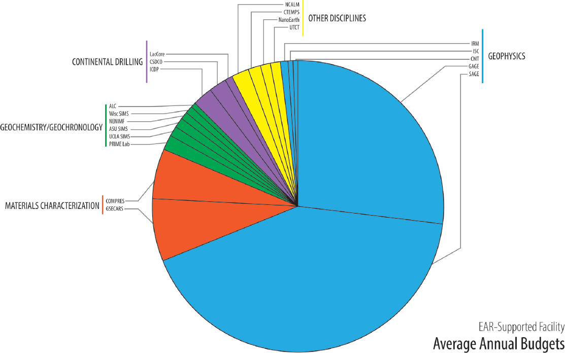
EAR supports 30 large multi-user (community) facilities that provide infrastructure and expertise for the Earth science research community (see Appendix D for more detailed information). The larger facilities support researchers through a combination of instruments, cyberinfrastructure, and training, whereas most of the smaller facilities emphasize either instrument-based infrastructure or cyberinfrastructure. Following is a description of the four largest facilities supported by EAR: SAGE, GAGE, GSECARS, and COMPRES. Average annual budgets for these facilities are reported in Table 3-1 and Figure 3-1.
TABLE 3-1 Average Annual Budgets of the Instrument-Based Facilities Supported by EAR
| EAR-Supported Facility | Acronym | Average Annual Budget |
|---|---|---|
| Geophysics | ||
| Seismological Facilities for the Advancement of Geoscience | SAGE | $17,500,000 |
| Geodetic Facility for the Advancement of Geoscience | GAGE | $11,400,000 |
| Institute for Rock Magnetism | IRM | $387,000 |
| International Seismological Centre | ISC | $250,000 |
| Global Centroid-Moment-Tensor Project | CMT | $123,000 |
| Materials Characterization | ||
| GeoSoilEnviroCARS Synchrotron Radiation Beamlines at the Advanced Photon Source | GSECARS | $2,900,000 |
| Consortium for Materials Properties Research in Earth Sciences | COMPRES | $2,400,000 |
| Geochemistry/Geochronology | ||
| Purdue Rare Isotope Measurement Laboratory | PRIME Lab | $708,000 |
| University of California, Los Angeles, Ion Probe Lab | UCLA SIMS | $468,000 |
| Arizona State University Ion Probe Lab | ASU SIMS | $402,000 |
| Northeast National Ion Microprobe Facility | NENIMF | $339,000 |
| University of Wisconsin SIMS Lab | Wisc SIMS | $330,000 |
| Arizona LaserChron Center | ALC | $259,000 |
| Support for Continental Scientific Drilling | ||
| International Continental Scientific Drilling Program | ICDP | $1,000,000 |
| Continental Scientific Drilling Coordination Office | CSDCO | $733,000 |
| National Lacustrine Core Facility | LacCore | $358,000 |
| Other Disciplines | ||
| National Center for Airborne Laser Mapping | NCALM | $877,000 |
| Center for Transformative Environmental Monitoring Programs | CTEMPS | $563,000 |
| Virginia Tech National Center for Earth and Environmental Nanotechnology Infrastructure | NanoEarth | $500,000 |
| University of Texas High-Resolution Computed X-Ray Tomography Facility | UTCT | $423,000 |
Seismological Facilities for the Advancement of Geoscience (SAGE)
SAGE provides instrumentation and data services in support of seismology, as well as education, workforce development, and community engagement activities. It is operated by the Incorporated Research Institutions for Seismology (IRIS) Consortium, which consists of more than 100 U.S. universities dedicated to operating science facilities to acquire, manage, and distribute seismological data. IRIS manages several instrument networks, including the Global Seismographic Network (an NSF partnership with USGS); Portable Array Seismic Studies of the Continental Lithosphere, a source of shared-use, portable seismic instruments; and a national magnetotelluric instrumentation facility. They also operate the IRIS Polar Support Facility (in coordination with UNAVCO Polar Facility), a Data Management Center, and an Education and Public Outreach program. In addition, IRIS operates the Transportable Array of EarthScope’s USArray, currently deployed in Alaska. In addition to an average annual budget of $17.5 million from EAR, SAGE receives ~$900,000 per year from the Office of Polar Programs.
Geodetic Facility for the Advancement of Geoscience (GAGE)
GAGE supports instruments needed for geodetic research as well as education and workforce training. It is operated by UNAVCO, a nonprofit, university-governed consortium. Through GAGE, UNAVCO supports instruments, data, and engineering for terrestrial and satellite geodetic technologies; GPS networks for Earth, atmospheric, and polar science applications; and NASA’s Global GNSS Network. Datasets and products provided or enabled by GAGE span the fields of seismology, hydrology, glaciology, geomorphology, geology, atmospheric sciences, data science, and others.
Scientific applications include the characterization of continental deformation and tectonic plate boundary processes; atmospheric, ice sheet, and glacier dynamics; and interactions among these components. GAGE receives an annual average budget of $11.4 million from EAR, with additional support of ~$840,000 per year from the Office of Polar Programs and ~$1 million per year from NASA.
NSF has been interested in understanding how management of seismological and geodetic facilities may change in the future and asked the committee to convene a workshop to discuss this topic (see Box 3-1).
GeoSoilEnviroCARS Synchrotron Radiation Beamlines at the Advanced Photon Source (GSECARS)
GSECARS is a national user facility for synchrotron radiation at the Advanced Photon Source (APS), Argonne National Laboratory. It supports research across several EAR core disciplinary programs. Since its inception in 1994, GSECARS has expanded to a current operating capacity of four simultaneous X-ray beamlines and hosts more than 500 visiting scientists per year. High-impact science projects are selected through an APS proposal process that awards DOE-supported beamtime, with instrumentation and personnel support managed by GSECARS and provided to users. Typically, EAR research awards cover travel and materials for visiting researchers. Techniques include high-pressure/high-temperature polycrystalline and single-crystal diffraction and spectroscopy using diamond anvil cells and the large-volume presses; deformation experiments; inelastic X-ray scattering; X-ray absorption fine structure spectroscopy; X-ray fluorescence microprobe analysis; and microtomography. Facilities at GSECARS support research in soil science, environmental geochemistry, porous media, cosmochemistry, rock and mineral physics, among others.
Consortium for Materials Properties Research in Earth Sciences (COMPRES)
COMPRES is a community-based consortium for high-pressure science and mineral physics that supports high-pressure facilities, including six different beamlines across all three U.S. synchrotrons (ALS, APS, and NSLS-II) and one university-housed facility that provides highly specialized, high-pressure assemblies to individual multi-anvil laboratories nationwide. COMPRES also seeds infrastructure development projects to foster new high-pressure technology, cyberinfrastructure, and education and outreach projects, as well as workshops on emerging methods. Since its inception in 2002, COMPRES has grown to include 70 active U.S. member institutions. Facilities supported by COMPRES harness new technology to determine the physical and mechanical properties of Earth materials under the wide range of conditions found on the Earth throughout geologic time. Experimental and computational studies of how rocks, minerals, and melts behave under wide-ranging conditions of pres-
sure, temperature, stress, oxygen fugacity, etc., are applied to interpreting geophysical and geochemical observations of the crust, mantle and core, and feed more broadly into understanding Earth’s dynamics and compositional heterogeneity. Although COMPRES is largely focused on high-pressure (mantle) mineral physics and rock deformation, crustal rock physics is a comparatively small part of COMPRES. New rock deformation initiatives, for example, those associated with SZ4D, have the potential to fill some of these gaps.
The COMPRES and GSECARS organizations have recently been asked to evaluate pros and cons of merging. See Box 3-2 for further discussion.
Instrument-Based Infrastructure Provided by Smaller Multi-User Facilities
In addition to SAGE, GAGE, GSECARS, and COMPRES, the Instrumentation and Facilities Program supports 16 multi-user facilities that develop and provide community access to instrumentation. The annual average funding for these facilities is ~$7.7 million. Following is a list of these multi-user facilities and their annual funding, organized by application.
Geophysics
In addition to SAGE and GAGE, there are three smaller EAR-supported facilities related primarily to geophysics, with an average annual budget of $760,000. These are the Institute for Rock Magnetism (IRM), which operates instruments for study of the magnetic properties of natural materials; the International Seismological Centre (ISC), which provides a catalog of worldwide earthquakes; and the Global Centroid-Moment-Tensor Project (CMT), which provides a comprehensive record of global seismic strain release.
Geochemistry/Geochronology
There are six EAR-supported facilities that utilize specialized mass spectrometers to generate geochemical and/or geochronologic information, with an average annual budget of $2.5 million. The Purdue Rare Isotope Measurement Laboratory (PRIME Lab) is a research and user facility for accelerator mass spectrometry, which is an analytical technique for measuring long-lived radionuclides. The University of California, Los Angeles, Ion Probe Lab (UCLA SIMS) facility consists of instruments used for U-Pb geochronology and high-precision stable isotope ratio measurements, including those for cosmochemistry. Arizona State University Ion Probe Lab (ASU SIMS) facility contains instruments for precise isotope ratio measurements and trace element analyses. The Northeast National Ion Microprobe Facility (NENIMF) consists of instruments used for high-precision measurements of light elements such as hydrogen, lithium, boron, carbon, nitrogen, and oxygen for applications such as magmatic volatiles in silicate glasses and analysis of biogenic carbonates. The University of Wisconsin SIMS Lab (Wisc SIMS) utilizes a large-radius, multicollector ion microprobe for analysis of stable isotopes (including Li, C, N, O, Mg, Si, S, Ca, and Fe). The Arizona LaserChron Center (ALC) utilizes laser-ablation inductively coupled plasma mass spectrometry to generate U-Th-Pb ages, Hf isotope ratios, and trace element concentrations of geologic materials, with research focused on continent growth, mountain building, and sediment generation and dispersal, among others.
The facilities share a mission to provide measurements for their own and other universities, national laboratories, and federal agencies. Most focus on supporting EAR-funded research, and many provide reduced user fees for NSF research projects. They also
share an interest in providing opportunities for research training and education, for improving quantitative standards, and for innovating new method development and measurement techniques.
Support for Continental Scientific Drilling
There are several facilities that provide instruments and analytical expertise for continental drilling. The International Continental Scientific Drilling Program (ICDP) is an international program to advance continental drilling. Projects are worldwide and are funded through international cost-sharing. The Continental Scientific Drilling Coordination Office (CSDCO) helps develop projects for drilling operations and supports project-specific logistics, sample and data management during drilling operations, and laboratories for core sample processing and curation. It also helps foster an engaged drilling community and broadens participation of underrepresented groups. The National Lacustrine Core Facility (LacCore), which is co-located with CSDCO, provides sedimentological analysis and archiving for lacustrine cores in support of projects related to paleoclimate, ecology, and biogeochemical cycles on the continents. LacCore operates open laboratories that provide field and laboratory equipment and staff expertise for core descriptions and analysis, as well as core storage and archival services. The average annual budget for these facilities is $2.1 million.
Other Disciplines
Other EAR-supported facilities include the National Center for Airborne Laser Mapping (NCALM), which provides research-quality airborne lidar observations to the scientific community; the Center for Transformative Environmental Monitoring Programs (CTEMPs), which offers community support for distributed fiber optic Raman backscatter distributed temperature sensing for observation of the spatial and temporal distribution of temperature; the Virginia Tech National Center for Earth and Environmental Nanotechnology Infrastructure (NanoEarth), which provides support to researchers who work with nanoscience- and nanotechnology-related aspects of the Earth and environmental sciences/engineering; and the University of Texas High-Resolution Computed X-Ray Tomography Facility (UTCT), which uses computed tomography to provide a nondestructive technique for visualizing the interior features of solid objects, and for obtaining digital information on their 3D geometries and properties. The average annual budget for these facilities is approximately $2.4 million.
Multi-User Facilities That Provide Cyberinfrastructure
EAR supports 10 multi-user facilities that develop and provide community access to cyberinfrastructure. These facilities are supported by Geoinformatics, EarthCube, Instrumentation and Facilities, and other programs, with an average of $10.7 million of funding provided per year (see Figure 3-2). The largest of the current multi-user facilities for cyberinfrastructure is the Interdisciplinary Earth Data Alliance (IEDA), which serves as a primary means for community data collection for global geochemistry and marine geoscience research and supports the preservation, discovery, retrieval, and analysis of a wide range of observational field and analytical data types.
For hydrology and surface processes, the Community Surface Dynamics Modeling System (CSDMS) provides human and cyberinfrastructure for advancing integrated modeling of Earth surface processes and promotes the development, use, and interoperability of software modules that predict the movement of fluids and the flux of sediment and solutes in landscapes. The Consortium of Universities for the Advancement of Hydrological Science, Inc. (CUAHSI) has a mission to develop infrastructure and services for advancing water science research and education. The OpenTopography High Resolution Data and Tools Facility (OpenTopo) provides web-based access to lidar-generated high-resolution topographic datasets and analysis tools in support of surface Earth process research and training.
Several of the cyberinfrastructure facilities support geophysics, petrology, and geochemistry. For example, the Computational Infrastructure for Geodynamics (CIG) builds and sustains cyberinfrastructure and computational capacity for geodynamics and seismology. Geo-Visualization and Data Analysis using the Magnetics Information Consortium (MagIC) develops and maintains an open community digital data archive for published rock and paleomagnetic data. Generic Mapping Tools (GMT) is an open-source collection of tools for manipulating geographic and Cartesian datasets and creating illustrations. Alpha-MELTS computational thermodynamics software includes models and algorithms for computational thermodynamics in geodynamics, geochemistry, and petrology.
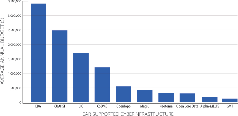
In addition, the Neotoma Paleoecology Database and Community provides an online hub for paleoenvironmental data (from the past 5 Ma), as well as research and education, and Open Core Data provides the infrastructure that makes data from scientific continental and ocean drilling projects discoverable, persistent, cit-able, and accessible.
Additional Multi-User Facilities
There are other examples of infrastructure funded by EAR that do not easily fit into the categories above. This includes instrumentation support for Critical Zone Observatories (CZOs), which are place-based, watershed-scale environmental laboratories,1 and support for the Southern California Earthquake Center2 (SCEC).
The CZO program (initiated in 2007) developed a network of nine intensive field monitoring sites (from California to Puerto Rico, White et al., 2015) focused on investigating what controls critical zone properties and processes, the response of the critical zone structure to climate and land-use change, and improved understanding of the critical zone to enhance ecosystem resilience and sustainability and to restore ecosystem function. Each CZO site (and its associated monitoring scheme) was selected to address hypotheses about some component of one or more of these questions. Collectively, these field observatories brought researchers together from a wide range of disciplines and enabled them to make sustained measurements over 7-12 years that led to fundamental discoveries and new theories for critical zone processes and evolution (Brantley et al., 2017). Over their program life, CZOs were used by thousands of researchers and educators. They served as testing grounds for new observational technologies and a training site for early career scientists. The CZO program is ending in 2020. Contingent on funding, some CZOs may remain active as monitoring platforms and community resources. Sustained access to CZO program data is actively being developed. The average annual amount of EAR support has been $7.4 million.
SCEC is a research collaboratory funded by EAR and USGS to coordinate fundamental research on earthquake processes, using Southern California as a natural laboratory. SCEC includes 20 core institutions and more than 60 participating institutions, which operate as a virtual organization to coordinate interdisciplinary earthquake system science. The SCEC program supports research and education in seismology, earthquake geology, tectonic geodesy, and computational science. It accomplishes this by collecting data from seismic and geodetic sensors, geologic field observations, and laboratory experiments; using physics-based modeling to synthesize knowledge of earthquake phenomena; and communicating understanding of seismic hazards to reduce risk and increase community
___________________
1 See http://criticalzone.org/national (accessed December 2, 2019).
2 See https://www.scec.org (accessed December 20, 2019).
resilience. The average annual budget is $2.9 million from EAR, with another $1.3-1.6 million per year from USGS.
Infrastructure Provided by Other Parts of NSF
NSF operates many facilities across the organization that support a wide variety of science, including EAR research. Below are some examples of infrastructure and programs used by EAR researchers that are supported by other divisions within GEO or other NSF directorates. This is not a comprehensive list; rather, it highlights some of the major facilities relevant to Earth sciences.
EarthCube
EarthCube3 aims to bring together the geoscience, geoinformatics, and data science communities to advance access to cyberinfrastructure and analysis of geoscience data. EarthCube has provided a pathway for community feedback from programs and divisions to be heard at the GEO level. EarthCube is a joint program of GEO and the Division of Advanced Cyberinfrastructure.
Academic Research Fleet and the JOIDES Resolution
The Division of Ocean Sciences (OCE) oversees the operation of the academic research fleet and the JOIDES Resolution. The academic research fleet has several ships that are essential for studying coastal zone and offshore processes. The JOIDES Resolution, a research vessel for scientific ocean drilling, contributes critical information for paleoclimate as well as petrologic, structural, and geochemical studies of the seafloor.
National Center for Atmospheric Research
The National Center for Atmospheric Research4 (NCAR) was established in 1960. It provides supercomputing facilities, computer models, data, and research aircraft to the atmospheric research community and related scientific disciplines. In addition to computational time for EAR researchers, it supports both forward climate and paleoclimate modeling, paleoclimate proxies and validation, and hydrologic sciences and modeling. It is supported by the Division of Atmospheric and Geospace Sciences in GEO.
Long-Term Ecological Research Program
The Directorate for Biological Sciences (BIO) oversees the Long-Term Ecological Research Program5 (LTER), which has been supported since 1980. The LTERs study ecosystems over long time periods at specific sites that range from Antarctica to the Alaskan Arctic. Currently, there are 28 sites in the LTER network. These sites are often multidisciplinary and have been of particular use for critical zone science. Some LTERs are co-located with EAR-funded CZOs to achieve complementary science objectives.
National Ecological Observatory Network
The National Ecological Observatory Network6 (NEON) consists of 20 study sites in the continental United States, Hawaii, and Puerto Rico that were chosen to represent different ecological regimes. Automated data are continuously collected and include tower-based weather and climate data; measurements of chemical and physical soil properties; rainfall rates; and visual data collected with cameras. NEON became operational in 2019 and has a planned lifetime of 30 years. NEON operations are funded by BIO.
Collections
Collections in Support of Biological Research, a program run by BIO, helps improve curation and accessibility of scientifically significant collections, including data and management. It also allows for transferring ownership of important collections. Another BIO program, Advancing Digitization of Biodiversity Collections, supports efforts to digitize basic temporal and geographic information on species occurrences, as well as images and other kinds of data. Major institutions that have benefited from these programs include the Paleontological Research Institution, which houses one of the 10 largest invertebrate paleontology collections in the United States; the Yale Peabody Museum, which holds historically important American fossil collections; and the University of Colorado Boulder, whose fossil insect collections are being studied to assess the response of terrestrial communities to environmental change.
___________________
3 See https://www.earthcube.org (accessed December 27, 2019).
4 See https://ncar.ucar.edu (accessed December 20, 2019).
5 See https://lternet.edu (accessed December 20, 2019).
6 See https://www.neonscience.org/about (accessed December 20, 2019).
Supercomputing Resources
NSF supports supercomputing through the Extreme Science and Engineering Discovery Environment (XSEDE), which coordinates sharing of supercomputing resources and high-end data analysis and visualization with researchers across the nation. XSEDE is a virtual organization that provides supercomputers and data storage beyond what is typically available to individual researchers, as well as the support structures required for scientists to take full advantage of these resources. XSEDE has adapted to meet diverse needs in high-performance computing, high-throughput computing, as well as more specialized needs in memory-intensive problems, visualization, and data analytics.
Select Infrastructure Provided by Other Agencies
In addition to NSF, infrastructure provided by other agencies is critical for EAR-funded research. Examples of relevant infrastructure are presented here, with expanded discussion of current and potential partnerships in Chapter 4.
USGS
USGS operates regional earthquake monitoring networks as part of the Advanced National Seismic System, which issues notifications and warnings of their occurrence and hazard impact, including tsunami warnings. It funds cooperative agreements with academia in connection with the Alaskan Volcano Observatory, the Pacific Northwest Seismic Network, the Center for the Study of Active Volcanoes, and the Yellowstone Seismic Network. USGS coordinates with NSF and IRIS to run the Global Seismic Network, which monitors worldwide seismicity. Seismometers are combined with other instruments to form geophysical observatories. EAR partners with USGS’s Powell Center for Data Synthesis and Analysis. In addition to monitoring seismic hazard, USGS operates the Volcano Hazards Program in close partnership with academia and is part of the EAR-supported Community Network for Volcanic Eruption Response (CONVERSE) Research Coordination Network. USGS also co-funds SCEC (discussed in a previous section) with EAR.
USGS also maintains the most comprehensive and consistent repository of water data in existence. This includes continuous observations of streamflow, groundwater elevation, water temperature, and sediment concentrations at thousands of monitoring locations throughout the United States and its territories. Additionally, USGS supports 29 Water Science Centers that produce important scientific datasets that are broadly disseminated to the community for scientific and management uses. USGS also develops and supports surface water, groundwater, and hydrogeochemistry/reactive-transport models that are broadly used by the EAR community. USGS laboratories also provide EAR-funded researchers with analytical capabilities in geochemistry and geochronology.
Through a partnership between USGS and NASA, land remote sensing products from the Landsat missions have been made broadly and freely available and are used extensively by EAR researchers. Additionally, USGS partners with universities to host eight Climate Adaptation Science Centers, which are devoted to co-producing actionable climate adaptation science that meets management needs of partners, particularly U.S. Department of the Interior agencies.
Jointly with the National Oceanic and Atmospheric Administration (NOAA), USGS operates the National Space Weather Prediction Network, which is critical for understanding the rate of change of Earth’s magnetic field.
NASA
The NASA Earth Surface and Interior Focus Area, part of the Earth Sciences Division, provides funding to supplement NSF’s support of GAGE. NASA’s Earth-orbiting satellites provide key high-resolution datasets to study climate change, topography and bathymetry, and the gravity field. NASA’s Earth Observing System Data and Information System is an essential resource for Earth data, which is accessed through several Distributed Active Archive Centers throughout the United States. The centers analyze, curate, and distribute data from NASA’s Earth-observing satellite missions and field measurement programs. Available data include synthetic aperture radar (SAR), sea ice, snow and ice, geodesy, and gravity measurements for solid Earth, ecology, and hydrology applications. NASA also deploys aircraft and uninhabited aerial vehicles (UAVs) for Earth science remote sensing applications, such as land deformation measured by SAR sensors on UAVs.7
The Hydrologic Sciences Branch at the NASA Goddard Space Flight Center supports the development of important land modeling capabilities. The Land Infor-
___________________
7 See https://uavsar.jpl.nasa.gov (accessed December 20, 2019).
mation System is an open-source framework for modeling land surface hydrology and assimilating a variety of remote sensing products. It is used by EAR-funded researchers to create synthetic spatio-temporal datasets of important land hydrology variables for which observations are otherwise unavailable.
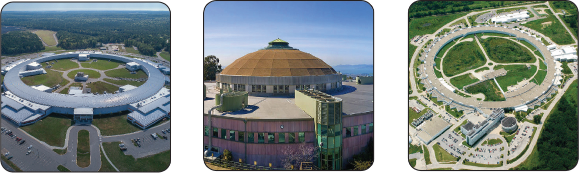
DOE
Synchrotron radiation sources are large-scale user facilities8 for highly-focused and intense X-rays that are operated by DOE (see Figure 3-3). GSECARS receives funding from EAR’s Instrumentation and Facilities Program to support human and physical infrastructure at the APS for a wide range of EAR disciplines, and COMPRES receives funding to support human and physical infrastructure in the area of high-pressure mineral physics. Other national user facilities supported by DOE and NSF do not receive EAR funds but are also used by EAR researchers. These include many of DOE’s National Laboratories (Argonne, Brookhaven, Lawrence Livermore, Los Alamos, Oakridge, Sandia, etc.). DOE infrastructure of growing interest to EAR researchers includes large-scale shockwave facilities to study dynamic processes such as collisions, Earth’s formation and evolution, and materials equations of state along pressure–temperature paths relevant to Earth’s interior.
DOE maintains field and experimental sites that provide data, models, and scientific partnerships for advancing understanding of the critical zone, water cycle, topography, and climate. These include the suite of Next Generation Ecosystem Experiment sites in the Arctic9 and tropics,10 the Spruce and Peatland Responses Under Changing Environments experiment,11 and the East River Study Area (discussed in further detail in Chapter 4). DOE also develops and offers access to significant modeling capabilities, a key example of which is the Energy Exascale Earth System Model. DOE has significant high-performance computing resources that are used for Earth science research.
DOE also has longer-term applied research facilities that support Earth science objectives. These include the Frontier Observatory for Research in Geothermal Energy, a geothermal test site, and the Deep Underground Science and Engineering Laboratory (also supported by NSF).
___________________
8 These include the Advanced Photon Source (APS, operated by UChicago Argonne LLC at Argonne National Laboratory), National Synchrotron Light Source-II (NSLS-II, operated by Brookhaven Science Associates at Brookhaven National Laboratory), and Advanced Light Source (ALS, operated by Lawrence Berkeley National Laboratory in Berkeley, California).
9 See https://ngee-arctic.ornl.gov (accessed December 20, 2019).
10 See https://ngee-tropics.lbl.gov (accessed December 20, 2019).
11 See https://mnspruce.ornl.gov (accessed December 20, 2019).
DOE/National Institutes of Health (NIH)
Biological information necessary to understand the evolution of biogeochemical cycles is provided largely by government agencies other than NSF. These include DOE’s Joint Genome Institute and NIH’s National Center for Biotechnology Information. In addition, the synchrotron sources described above are used to characterize chemical properties.
Smithsonian Institution and Museum Collections
The museums of the Smithsonian Institution hold the principal federally supported physical collections, whose millions of specimens provide a foundation for a diversity of scientific and cultural research. Of particular relevance to EAR are the Smithsonian’s holdings in paleontology and stratigraphy, mineral sciences, and meteoritics. Numerous municipal and private museums play similar roles for EAR-supported scientists.
U.S. Department of Agriculture (USDA)
The Natural Resources Conservation Service operates the Soil Climate Analysis Network and Snow Telemetry networks, which provide quality-controlled measurements of soil moisture and snow water equivalent, respectively, to advance understanding of ecohydrologic processes and models. It also maintains, updates, and provides access to spatial soil datasets that inform models of surface and subsurface hydrology. The Agricultural Research Service operates watershed-scale experimental facilities throughout the United States. The U.S. Forest Service Forests and Ranges program also operates long-term, watershed-scale study sites, with a focus on forest landscapes and management practices. These facilities support research aligned with the water cycle, critical zone, and topography priority questions, and provide legacy datasets characterizing climate, hydrology, vegetation, and soils.
NOAA
The National Centers for Environmental Prediction produce and serve weather and climate forecast and historical datasets that are used as climate forcings for hydrologic and other land models. The National Centers for Environmental Information (NCEI) provides access to data such as historical climate records from across several observational networks, including archived precipitation datasets. Additionally, the NCEI paleoclimate database is extensively used by EAR researchers and others worldwide. NOAA’s National Water Center recently implemented a National Water Model that provides fine-scale, near-historical, and forecast streamflow conditions at millions of stream segments throughout the continental United States. It was developed from modeling technology developed at NCAR and supported in part by EAR.
RELATIONSHIP BETWEEN CURRENT INFRASTRUCTURE AND THE SCIENCE PRIORITIES
There is a strong correlation between the existing infrastructure and facilities supported by EAR and the current needs determined for the science priorities discussed in Chapter 2. Table 3-2 shows how the science priorities and the existing facilities are connected. It is clear from this compilation that many of the current EAR facilities will continue to be needed to address the science priorities outlined in this report.
EVALUATION, ASSESSMENT, AND PRIORITIZATION OF FACILITIES AND INFRASTRUCTURE
To address Task 2B, the committee described research conducted in each of the EAR-supported facilities identified by NSF at the beginning of this study. It also attempted to evaluate the potential impact of the supported research on the priority science questions. Descriptions of each facility were assembled from information provided directly by facility operators, facility websites, and NSF award abstracts,12 as well as the knowledge and direct experiences of committee members. It was difficult to access information that could be used to evaluate facility performance and impact. Project outcomes reports13 were not available for all facility awards, and most of the available reports contained only limited information. However, several facilities provided comprehensive information to the committee, including annual reports, metrics used to assess success, and impacts. About half of the multi-user facility operators also responded to a committee question regarding primary criteria to consider when
___________________
12 See https://www.nsf.gov/awardsearch (accessed March 23, 2020).
13 See https://www.research.gov (accessed March 23, 2020).
TABLE 3-2 Connections Between the Science Priorities and Existing Infrastructure and Facilities
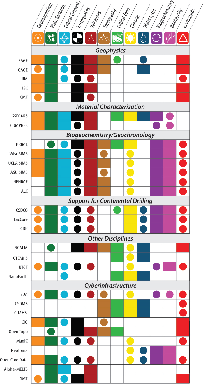 |
Abbreviations in first column: SAGE: Seismological Facilities for the Advancement of Geoscience; GAGE: Geodetic Facility for the Advancement of Geoscience; IRM: Institute for Rock Magnetism; ISC: International Seismological Center; CMT: Global Centroid-Moment-Tensor Project; GSECARS: GeoSoilEnviroCARS Synchrotron Radiation Beamlines at the Advanced Photon Source; COMPRES: Consortium for Materials Properties Research in Earth Sciences; PRIME: Purdue Rare Isotope Measurement Laboratory; Wisc SIMS: University of Wisconsin SIMS Lab; UCLA SIMS: University of California, Los Angeles, Ion Probe Lab; ASU SIMS: Arizona State University Ion Probe Lab; NENIMF: Northeast National Ion Microprobe Facility; ALC: Arizona LaserChron Center; CSDCO: Continental Scientific Drilling Coordination Office; LacCore: National Lacustrine Core Facility; ICDP: International Continental Scientific Drilling Program; NCALM: National Center for Airborne Laser Mapping; CTEMPS: Center for Transformative Environmental Monitoring Programs; UTCT: University of Texas High-Resolution Computed X-Ray Tomography Facility; NanoEarth: Virginia Tech National Center for Earth and Environmental Nanotechnology Infrastructure; IEDA: Interdisciplinary Earth Data Alliance; CSDMS: Community Surface Dynamics Modeling System; CUAHSI: Consortium of Universities for the Advancement of Hydrological Science, Inc.; CIG: Computational Infrastructure for Geodynamics; OpenTopo: OpenTopography High Resolution Data and Tools Facility; MagIC: Geo-Visualization and Data Analysis using the Magnetics Information Consortium; Neotoma: Neotoma Paleoecology Database and Community; GMT: Generic Mapping Tools. |
NOTES: Science priorities identified in the report are across the top and existing infrastructure and facilities are down the side. A fully colored box denotes a facility that provides essential capabilities needed to address a priority science question, while a colored circle denotes a facility that is relevant for a question. Determinations were made based on descriptions provided by the facilities, NSF award abstracts, and information taken from the community input questionnaire.
making decisions to establish new facilities or maintain (or sunset) existing facilities.
The committee asked EAR to provide information about the methods used to assess the effectiveness of the infrastructure it supports, with particular interest in understanding whether EAR has a process for evaluating the degree to which facilities are serving the goals of the Division. In response, the committee was informed that facilities are evaluated by EAR personnel, both annually and at the end of each funding cycle, and through the peer-review system with each proposal submitted for continued facility support. Based on committee members’ individual experiences (e.g., serving on an NSF Committee of Visitors panel, prior experience as an NSF rotator, involvement with NSF-supported facilities), the evaluation systems that EAR has in place work well for individual facilities. However, because these evaluations are not publicly available, it was not possible for this committee to provide an informed evaluation of their effectiveness.
In an effort to facilitate more transparent evaluation of EAR-supported infrastructure, from individual facilities to the entire EAR infrastructure portfolio, the committee encourages EAR to consider establishing a metrics-based system that can assess the effectiveness and impact of existing facilities. For example, relevant metrics could include the number of publications that use data generated, analyzed, modeled, and/or archived by the facility, and the citations and awards garnered by these publications. Other criteria could include whether instruments, cyberinfrastructure, and personnel capabilities remain state of the art; the degree to which the facility takes advantage of new technologies and drives the development of new instruments, software tools, open-source protocols, data processing packages, models, analytical techniques, and science applications; and whether this opens new avenues of research for Earth science communities. Activity levels could also be tracked, such as size and breadth of user communities (in total and NSF supported) that conducted research in collaboration with the facility, those institutions served, the amount of NSF awards supported by facility activities, level of demand, partnerships built with other agencies, and database entries that contain facility information. Contributions to development of human infrastructure could be monitored through following the demographic and professional trends of scientists who work or conduct research at the facility, professional development of students and early career investigators who have been involved in facility activities, outreach activities that engage nonscientists in NSF-sponsored research, and accomplishments in improving Earth scientists’ diversity, equity, and inclusion. The degree to which facilities provide community leadership and whether facility operators are leaders in their fields could also be considered. There may be a need for different facilities to be evaluated with slightly different (“tailored”) sets of metrics, depending on the work done at the facility. Many of the examples listed above are already used in facility evaluation, but by explicitly stating the metrics considered in evaluations, the Earth science community would be better informed about the criteria used and valued.
A tailored set of metrics would also allow EAR and the Earth science community to periodically evaluate the performance and impact of the full portfolio of facilities and infrastructure. This would be especially helpful when evaluating the potential impact of proposed new facilities, deciding which facilities could be ramped down or sunsetted, and exploring whether changing science priorities require rebalancing infrastructure investments. Evaluation metrics and a synopsis of the assessment process could be made publicly available, perhaps on NSF’s website. Additionally, relevant information about the entire portfolio of EAR-supported facilities could be compiled and available for easy public access, instead of only being available via the NSF awards database (as it is currently). Such information is essential to set priorities for infrastructure investments over the next decade, especially with the continued desire from EAR-supported investigators to incorporate novel and transformative technologies into their research.
Recommendation: EAR-supported facilities and the entire portfolio of EAR-supported infrastructure should be regularly evaluated using stated criteria in order to prioritize future infrastructure investments, sunset facilities as needed, and adapt to changing science priorities.
FUTURE INFRASTRUCTURE NEEDS
Future Needs Identified by Community Responses
The community input questionnaire14 requested that participants “List up to 3 ideas for infrastructure
___________________
14 See further discussion of the community input in Chapter 2. The form is reproduced in Appendix B.
(physical infrastructure, cyberinfrastructure, data management systems, etc.) that will be needed to address the above topics or issues over the next decade.” Common themes regarding physical infrastructure and collections included the following:
- the need for centers or facilities that contain relevant instruments and expertise that are currently beyond the reach of a single investigator. These centers would ideally provide access to instruments and the expertise to operate them, train users in their operation, and help drive community initiatives.
- a need for facilities that archive geological samples and materials. Most individual investigators and their universities are not able to provide long-term archives, resulting in a real concern that critical (and in some cases irreplaceable) geological collections are being lost.
- the need to continue, and perhaps expand support for, traditional field-based geologic investigations.
- a need for geophysical, geochemical, biological, and bathymetric information from the oceans to address many problems in Earth science.
Regarding cyberinfrastructure, nearly half of the respondents noted that their research community is in critical need of improved data management systems. A common suggestion was that NSF build a system of databases that serves all disciplines in Earth sciences and provides capabilities for data access, analysis, and integration. It was apparent from the community that many respondents were either not aware of EarthCube or felt that EarthCube did not meet their current or anticipated cyberinfrastructure needs.
Many respondents also emphasized the need for enhanced training of researchers who can use sophisticated instruments and work with large and complex datasets, or who collaborate with scientists and engineers in complementary disciplines. There were also calls for improvements in access to high-performance computing, software and modeling, and for enhanced outreach to increase access to Earth science information and to grow diversity among Earth scientists.
Future Needs Identified by Facility Operators
EAR-supported multi-user facility operators (in sections above) were also asked about their top priorities if they had 10% more funding. Approximately half of them provided answers. Priorities for additional funding included hiring more technical staff and post-doctoral researchers, developing new instruments and/or capabilities, maintaining or modernizing instruments, initiating new projects, building community support (e.g., through development of new standards), and increasing outreach opportunities.
Future Needs Related to the Science Priority Questions
There are a range of instruments, facilities, and capabilities that will be needed to fully address the science priority questions over the next decade. As with the science questions themselves, the information below was compiled from literature review, community white papers, community responses, and input from facilities. These are discussed below, generally moving from Earth’s interior to its surface.
Instrument-Based Capabilities
Geomagnetics, Plate Tectonics, Critical Elements, Earthquakes, Volcanoes
![]()
Studies of the core and magnetic field, plate tectonics, earthquakes, volcanoes and magmatic systems, and critical elements have need for enhanced capabilities to observe and monitor current geologic processes. Research in these areas would benefit from a subduction zone observatory, which could lead to new understanding of subduction-related phenomena and advance our ability to forecast earthquakes, tsunamis, and perhaps volcanic eruptions.
Instrumentation to observe earthquakes must be in place and ready to record at all times, and it must persist over time. Seismic and geodetic facilities for earthquake monitoring have done an excellent job of providing information to the research community, but the unpredictable nature of earthquakes means that instrumentation must be distributed efficiently, with reserve capacity to supplement them once an event has occurred. Alternative strategies include setting up observatories to catch earthquakes as they occur (Ben-Zion, 2019), temporary instrumentation followed by deliberately triggering an earthquake (Savage et al., 2017),
and exploiting new sensor technologies, such as monitoring with dark fiber through distributed acoustic sensing (Marra et al., 2018). These developments will not only be important for deep Earth processes but will open the field of environmental seismology and increase knowledge of soils, water storage, and hillslope failure.
Studies of volcanic systems require a dedicated set of synchronized portable field instruments including a wide range of high-resolution video cameras across multiple wavebands, broadband seismometers, infra-sound sensors, GPS receivers, gas cameras and spectrometers, and ash samplers. This hardware would be designed to be deployed during volcanic crises in a rapid-response fashion to observe eruption dynamics and sample the products of volcanic eruption cycles at volcanoes within the United States and contribute to international efforts worldwide.
The plate tectonics and geomagnetics questions need data with expanded global and temporal coverage to provide information about how plate tectonics (and predecessor processes) and the geodynamo have operated through geologic time. Particularly useful are collections of traditional types of outcrop-based geologic observations, as well as improved integration with a broader array of drill cores from continental and marine sedimentary sequences. An essential activity will be to sustain or even broaden access to samples and cores that have already been acquired but are at risk of being lost.
Plate tectonics, geomagnetics, volcanoes, and critical elements all need the following:
- laboratory facilities to carry out experiments under the full range of environmental conditions required to understand deformation processes;
- facilities with instrumentation for characterization of static and transport properties of Earth materials at Earth conditions (composition, temperature, pressure, stress) to build the appropriate constitutive laws, including new spectroscopic techniques; and
- development of capabilities to measure and model thermodynamic processes at time scales ranging from shock to plate movement, including kinetics and diffusion at extreme conditions and nonequilibrium processes.
The geomagnetics question also needs equipment that is tailored for measurements of magnetic signals in individual grains.
In addition, the critical elements and volcanoes questions require analytical instrumentation to obtain improved records of igneous/metamorphic/tectonic processes operating through Earth’s history (e.g., analysis of different minerals and different geochemical/isotopic systems, on smaller spatial scale, with improved precision/accuracy and ability to determine oxidation state of minerals and melts) and new experimental methods in shockless compression by laser and pulsed power to allow the study of equations of state and physical properties of melts and minerals at conditions spanning the Earth and super-Earth interiors.
For these questions, finer spatial resolution of analyses will be a great strength. The volume of material needed for a geochemical or geochronologic analysis has been steadily decreasing, such that scanning electron microscopes and electron microprobes can be used to image and analyze materials at very fine scales, including light elements. In addition, transmission electron microscopes and atom probes are now capable of imaging and analyzing individual atoms. The next 10 years should see the application of this technology to a broad range of geologic materials, with new insights into the geochemistry of nano-scale inclusions and isotopic reservoirs.
Improved temporal resolution will also be essential. For much of geologic time, the uncertainty of geochronologic ages greatly exceeds the time scale of fundamental events and processes. New and anticipated technological developments (e.g., improved decay constants) provide opportunities to significantly improve the precision and accuracy of geochronologic rates and ages (Harrison et al., 2015). Advances that allow better linkage of processes and conditions to time are needed (e.g., improved calibration of the geologic time scale is important to reconstructing the carbon-oxygen-hydrogen-nitrogen system and its control on habitability).
Topography, Critical Zone, Climate, Water Cycle, Geohazards
![]()
There are shared threads through these five science questions that call on common instrumentation and facility needs. All five need:
- high-resolution data on topography and vegetation and repeat survey data for change detection;
- subsurface characterization of material properties that influence water storage and flux, pore pressure, mass strength, and solute and gas chemistry;
- long-term observatories and experimental watersheds to investigate processes;
- precipitation and runoff monitoring stations;
- satellite-based long-term observational data;
- ability to quantify long-term rates of erosion, exhumation, uplift, and subsidence; and
- proxy measurements of past environmental conditions.
The instrumentation and facilities for each of these categories are briefly summarized below.
Airborne lidar has been a breakthrough technology that enables thousands of square kilometers to be surveyed at resolutions of tens of centimeters in a single campaign. In contrast to photogrammetry, airborne lidar can penetrate dense forests to document the topography of the ground surface as well as the vegetation canopy structure. Research communities are increasingly comparing existing lidar data with new surveys for change detection or are working in new areas with the intent for repeat surveys.
Presently, satellite-based lidar has large footprints and limited coverage. Satellite-based photography, however, provides global coverage at sub-meter resolution, with the ability to do repeat observations. Currently, high-resolution topographic data are not available for most of the Earth. Although photogrammetry is limited by forest and brush cover, for much of the Earth vegetation density is low, and commonly where it is dense, the current topographic data is so coarse that satellite-derived topography, even with vegetation effects, will be a valuable improvement. The Polar Geospatial Center digital elevation surface models for the Arctic and Antarctica are two such data products. Sustained Landsat surveys are now enabling researchers to make movies of Earth surface dynamics that span more than 30 years. On the local scale, drone-based, photography-derived Structure from Motion digital surface topography will become increasingly used in field studies. Drone-based lidar surveys are likely to become progressively more widely used in intermediate-scale field studies.
While lidar has revolutionized understanding of Earth’s surface, near-surface geophysics (from the ground surface to depths of tens to hundreds of meters [e.g., Kruse, 2013]) is revealing the structure of the subsurface domain. Advances in technology, and increasing access to and knowledge of geophysical tools, will play an important role in advancing these science priority questions. Drilling and borehole characterization is an important part of understanding the subsurface, as is subsequent instrumenting of the holes to characterize materials and subsurface dynamics.
Long-term field observatories and experimental watersheds play a unique role in Earth sciences, enabling researchers to test hypotheses that guide measurements to quantify and advance understanding of physical and biological processes (NRC, 2014). Observatories create a structure in which researchers can collaborate across a wide range of disciplines (such as Earth science, climate science, and biological science) to tackle major questions that lie beyond any single field. Observatory sites also serve as trackers of the rapidly changing Earth. The CZO program, which provided the first sustained intensive investigation of critical zone processes and evolution and inspired similar programs in the United States and other countries, sunsets in 2020. This will lead to losses of infrastructure that support the critical zone and water cycle questions.
The network of weather stations and streamflow monitoring stations operated by federal, state, and local agencies provides essential data on water inputs and outflows. Accessibility and quality control of such data has had a profound impact on scientific research and will continue to be essential, although budgetary limitations and changing priorities have led to loss of weather and gauging stations. It is important to advance efforts to preserve, generalize, and make available data relevant to climate monitoring, including the information coming from NOAA’s Global Historical Climatology Network15 and USDA’s Parameter-elevation Regressions on Independent Slopes Model.16
Satellite-based Earth observations provide essential data for these science questions and several others. Such satellite systems include:
- the Global Precipitation Measurement constellation of satellites, which provide global coverage of precipitation from microwave sensors (Liu et al., 2017);
- Gravity Recovery and Climate Experiment (GRACE) and GRACE Follow-On missions,
___________________
15 See https://www.ncdc.noaa.gov/data-access/land-basedstation-data/land-based-datasets/global-historical-climatology-network-ghcn (accessed December 27, 2019).
16 See https://www.wcc.nrcs.usda.gov/climate/prism.html (accessed December 27, 2019).
-
which enable global tracking of underground storage for the amount of water held in soil moisture, lakes and rivers, ice sheets and glaciers, and sea-level changed caused by the addition of water to the ocean;
- Soil Moisture Active Passive (SMAP) provides information on soil moisture and freeze-thaw activity in the first 5 cm from the surface on a 2- to 3-day repeat at scales of about 40 km (Felfelani et al., 2018);
- Interferometric SAR (InSAR) enables monitoring of surface deformation, including faulting, landslides, groundwater storage change, ice sheet motion, permafrost change, and tracking of magma movement and volcanic deformation. A joint NASA and Indian satellite will launch in 2021, succeeding current European and Japanese missions; and
- Landsat and several commercial companies provide satellite photographic and spectral imagery at various repeat time and resolution. Landsat is particularly important in its sustained monitoring program and free access to high-quality data.
A thorough review of opportunities, applications, and future missions relative to Earth science can be found in Thriving on Our Changing Planet: A Decadal Strategy for Earth Observation from Space (NASEM, 2018a).
Advances in noble gas geochemistry, thermochronometry, cosmogenic nuclide dating, and clumped isotope thermometry have revolutionized our ability to document Earth surface dynamics, such as long-term rates of erosion, exhumation, uplift, and subsidence. Water stable isotope reconstructions based on ice cores, fossil shells and plants, volcanic ash, and other geologic archives enable interpretation of past environmental conditions. Such proxy measurements provide necessary information to understand climate history and are an important component for all five science priority questions and others as well. Geochronological techniques, such as radiocarbon dating or optically stimulated luminescence dating, are essential to provide a temporal framework for proxy records of past environmental change. Improved precision and accuracy of these tools as well as further development of geochronological techniques that help to fill temporal gaps or access different archives will be vital to constraining both absolute time and rates of environmental change.
Biodiversity and Biogeochemical Cycles
![]()
For biodiversity and biogeochemical cycles, a range of instrument-based capabilities are needed to constrain what happened, where, when, and at what rate. These include:
- development of dedicated facilities for analysis of geological and biological samples and recovery and archiving of long-term geological records (paleontologic, stratigraphic, geochemical, climatic, etc.) from outcrops and continuous cores;
- upgrades of synchrotron sources and methods at individual beamlines; and
- development of dedicated geochronology facilities as well as new geochronologic tools to resolve evolutionary rates and processes and to constrain the timing and rates of biogeochemical transitions and perturbations.
Biodiversity also requires the support of existing facilities and creation of new ones for analysis of biological samples and sediments to yield paleoenvironmental proxy data for factors such as climate and atmospheric and oceanic chemistry.
Progress depends on spatio-temporally constrained paleontological, geochemical, genomic, stratigraphic, and sedimentological records; precise geochronology; and a process-oriented understanding of environmental proxies.
Cyberinfrastructure-Based Capabilities
Cyberinfrastructure will be needed to support both model development and data analysis and integration. This will include the development or use of standardized data formats, storage of data and model results and the ability to access them, and data archiving (whether at commercially available or field-specific data repositories). There will be an increasing need for multi-scale, multi-physics models that use cutting-edge theory, numerical methods, and high-performance computing that incorporate knowledge from new and old measurements.
Geomagnetics, Plate Tectonics, Critical Elements, Earthquakes, Volcanoes
![]()
Addressing research about processes that operate within the Earth will need efficient access to geologic, geochemical, and geophysical information that has been generated from existing and new samples and records, which will require databases to store and provide this information. Although a daunting challenge, the alternative, which is that existing information may be lost, is unacceptable. The rapidly increasing size of geologic datasets adds considerable urgency to this challenge.
Once databases are available, advanced tools for analysis, visualization, and modeling of large volumes of data are needed. For example, while technological developments in X-ray detectors are making real-time chemical reactions observable, synchrotrons can generate terabytes of data in a single day, creating a cyberinfrastructure challenge for both users and facilities. This will only increase as new technologies such as distributed acoustic sensing using dark fiber become widely available. Other examples include:
- improved modeling capabilities to investigate key processes driving the rise of magma from storage to eruption;
- computational infrastructure for geodynamic modeling of Earth’s interior; and
- modeling capabilities with open-source tools, software optimization, and high-performance computing to represent geometrically and dynamically complex fault systems over a range of relevant scales.
In addition, there will be a need for high-performance computing with state-of-the-art techniques for data assimilation. These can be used for numerical simulations that incorporate newly determined constitutive laws for the deformation of Earth materials, applicable to a range of plate boundary processes from faulting to long-term plate motion. For brittle deformation, such laws will be important on intermediate scales—larger than typical laboratory samples but smaller than the spatial discretization in typical simulations.
Modeling collaboratories provide exemplars of the integration of data and modeling and can coordinate and support the distributed development of a diverse set of numerical codes, training, scientific exchange, and access to large-scale computations. They can provide an incubator for the new generation of models that incorporate theory and data, and are capable of informing and guiding new data acquisition to fill gaps in physical understanding.
Topography, Critical Zone, Climate, Water Cycle, Geohazards
![]()
Data access for processes that operate on Earth’s surface has been improved by providing lidar data through OpenTopography and various hydrologic and critical zone datasets through the CUAHSI Hydroshare program. However, surface processes data lack the organization and ease by which seismic data worldwide are made available. Because of a lack of shared observational data storage at the individual, state, and federal level, it is quite difficult to quickly discover and use previous and ongoing surface process data collections (e.g., erosion rates, soil moisture dynamics, results of drilling bore holes, groundwater levels, climatic measurements). In addition, there are no centralized and approved data centers for the diverse data types these communities produce. Some databases are available for the geochronologic, geochemical, and petrologic data needed to study Earth surface processes and their interactions with other components of the Earth system through geologic time (e.g., EarthChem), but data standards and access are limited and heterogeneous. The ability to generate data far outstrips the funding currently available to store and access in open databases expected to have a sustained presence into the future.
A common goal of these questions is to build models that can exploit the progressively increasing resolution of spatial and temporal data to predict event-based Earth surface dynamics. High-performance computing will play a central role in enabling the creation of a first-generation high-resolution global digital surface model from satellite imagery (e.g., the Polar Geospatial Center, see Chapter 4). Among many other objectives, enhanced high-performance computing access will enable large-scale, high-resolution water resources models to address the coupling of natural processes and management strategies; improved prediction of the timing and location of landslides in storm events; event-based models of landscape evolution over large scales; improved earthquake prediction through the ability to do large-scale computations and include the
complex built environment of urban areas; and inclusion of spatially varying critical zone properties in the prediction of land surface interaction with climate. High-performance computing will also enable coupling of landscape evolution models that capture the complexity of these interactions with continent- to global-scale geodynamic models.
Cyberinfrastructure that supports the integration of paleoclimate records with each other and with other archives of Earth’s history and evolution, including paleoclimate models, is at varying stages of development within different subdisciplines and will require continued support to better leverage existing and new data collected by EAR scientists. High-performance computing is required for climate and Earth systems models spanning simulations of past to future, helping to build a critical bridge between studies of deep time and the anticipated emergence of near-future climates with few counterparts in human experience (Burke et al., 2018; Haywood et al., 2019).
For geohazards, there will be continued need for access to high-performance computing coupled with a community-modeling ecosystem to simulate geohazards; scalable algorithms to extract meaning for large data volumes; and for model-driven approaches, capability computing that allows for increasingly realistic simulations. There will be increasing need for cyberinfrastructure to process massive datasets that contain information on wide ranges of spatial and temporal scales, and across a broad range of topics (seismology, geodesy, lidar, InSAR, heat flow, topography, geochronology, mineral physics, geochemistry, hydrology, weather, etc.) and for information to be rapidly accessible for prediction and response.
Biodiversity and Biogeochemical Cycles
![]()
Addressing these questions involves the development of databases that unify high-quality, curated, stratigraphic, lithological, biological, and geochemical information, and the tools to search, access, visualize, and analyze the diverse datasets and conduct appropriate statistical analyses. There will be increasing need to access and integrate model data and data from different fields—stratigraphy, geochronology, geochemistry, paleontology, molecular evolution, microbial diversity, and molecular microbiology, for example. Essential sequence information is accessible from non–NSF-funded databases such as the GenBank (NIH sequence database). Bioinformatic tools to analyze these types of data are developed largely outside of GEO.
Future research will require enhanced cyberinfrastructure given the large size, diverse nature, and temporal scope of the relevant data. It is important to bear in mind that an enormous amount of relevant data resides in a century or more of published literature that has not been digitized. Improvements could include extension of a Neotoma database–like approach to deep-time records; automated mining of published literature; curation of new and legacy data; development of community standards for curating new data as they are produced; the ability to seamlessly integrate data from diverse geologic and biologic disciplines; recovery and archiving of long-term geological records (paleontologic, stratigraphic, geochemical, climatic, etc.) from outcrops and continuous cores obtained by oceanic and continental drilling; and automated access to an improved global Geologic Time Scale. In addition, increasing model complexity requires high-performance computing on a large scale. Phylogenetic, biogeochemical, and other models not only assimilate massive amounts of data; modeling results can in turn direct future data-gathering efforts. Advances in machine learning may help to harness the power of these data.
Personnel-Based Capabilities
![]()
Progress on the science priority questions and other innovative Earth science research will be made by researchers who generate critical new observations and interpretations, as well as experts who create new methods to integrate, analyze, and model this information. The Earth science community needs to develop a workforce that has high levels of expertise with the instruments and data used in each discipline, as well as the ability to work with information from other Earth science fields and an increasingly broad range of other fields. There will continue to be a need for training of field geologists, as field geology is an essential aspect of many Earth science research areas. The trend away from field camps and the tradition of field geology was a concern raised by many of the respondents in the community input. However, careers beyond field geology need to be emphasized in order to attract a more diverse workforce (I. Casellas-Connors, Texas A&M University, presentation to the committee, March 14, 2019). A more diverse workforce will drive exciting
research and increase the connections between Earth scientists and society as a whole (see Chapter 2 and the discussion of Human Infrastructure below for additional discussion).
Because much of the novel research in Earth science increasingly involves integration of information from different methods and disciplines, addressing important science questions will require researchers who can generate new information utilizing field skills and increasingly complex and specialized instruments, integrate the diverse types of information, and develop new methods for interrogating and modeling the large and complex datasets. For example, the next decade of Earth science will require personnel able to design, build, and use increasingly complex and sophisticated instruments, and to access, integrate, and analyze large datasets that have diverse formats and a broad range of spatial and temporal scales. We are already seeing emergence of a new field of Earth data science as a specific discipline.
Personnel infrastructure will also be needed to support acquisition and analysis of geochronologic, geochemical, and geophysical data, and the development of new analytical techniques and modeling approaches. Dedicated software engineers and computer scientists will be needed to handle the expanding role of computational research in Earth science, both in terms of data analysis and physical processes modeling, as well as the increasing sophistication of software. The lack of dedicated software engineers for Earth science applications is often an issue in cyberinfrastructure, data analysis software, and database development.
Because of the significant need for disciplinary excellence and expertise, this type of training is currently provided largely by individual investigators or by small training programs for analytical, experimental, field, and computational methods (e.g., the Cooperative Institute for Dynamic Earth Research, CIG, the Paleobiology Short Course). Funding for small collaborative, multi- or interdisciplinary projects and post-doctoral projects that train post-doctoral researchers in new disciplines can also provide the necessary disciplinary and topical breadth to trainees. Continued emphasis on the proven success of NSF graduate research fellowships, post-doctoral fellowships, and faculty early-career development programs can ensure the training and continued development of a strong, vibrant community of experts who can address future challenges in the field.
RECOMMENDATIONS FOR POSSIBLE NEW INITIATIVES
In the next section, the committee offers suggestions of possible new initiatives that EAR and the Earth sciences community may wish to consider. All these initiatives originate from EAR research communities and are based on community input responses, community white papers or reports, and/or presentations in public sessions.
While the committee feels that significant progress can be made on the science priorities within the context of the present EAR budget, it is worth noting that EAR’s infrastructure support has been flat for the past decade and that some of these proposed initiatives would demand significant infrastructure investment. For example, full implementation of SZ4D or the continental critical zone campaign would likely be too costly to incorporate into the current EAR budget. Due to their scale, in most cases funding these initiatives will require either a source of new funds (e.g., NSF’s Mid-Scale Research Infrastructure or Major Research Equipment and Facilities Construction) and/or sunset-ting of current programs. In all cases, the committee strongly believes that these initiatives (or others) should not be developed at the expense of the core disciplinary research programs.
These initiatives were chosen because they provide potentially transformative capabilities to address and support the science priorities discussed in Chapter 2 and the infrastructure needs discussed previously in this chapter. Three of these initiatives—creating a national consortium for geochronology, funding a U.S.based very large multi-anvil press user facility, and establishing a near-surface geophysics center—are well developed, with years of community involvement and support, including white papers, endorsement in previous community reports, and/or proposals to NSF. Another initiative, SZ4D, has had strong community support in recent years, including a large NSF-supported workshop and three funded research coordination networks (RCNs), but is still developing its program plan. Other possible initiatives discussed below—continental drilling, Earth archives, and the continental critical zone—have various levels of community engagement and program development. Further exploration of these possible initiatives would need broad involvement of the Earth science community via workshops, white papers, and coordinating mechanisms such as RCNs. The committee’s recommendations are based
on both the potential scientific impact and the developmental stage of the proposed initiatives.
National Consortium for Geochronology
![]()
Given that nearly all the high-priority science questions require improved constraints on the ages and rates of geologic processes, it will be important for EAR to build enhanced geochronologic capabilities. Questions concerning the origin and dynamics of Earth’s interior will require the ability to determine the timing and rates of geologic events and processes significantly better than is possible with current instruments and methods. Understanding how geologic, hydrologic, atmospheric, and biologic processes shape the surface of the Earth, and control our existence, requires much better temporal coverage than is currently available. All applications will benefit from enhanced abilities to acquire complementary geochemical and structural information and will require improved cyberinfrastructure to integrate geochronologic/geochemical/crystallographic data with information from other disciplines.
As highlighted in New Research Opportunities in the Earth Sciences (NRC, 2012) and It’s About Time: Opportunities & Challenges for U.S. Geochronology (Harrison et al., 2015), significant issues exist with respect to providing the geochronologic information that is essential for current and future research in Earth science. Issues arise principally from the current funding model, in which most geochronology laboratories are supported mainly by awards to address specific science questions, with little or no funding awarded to support laboratory infrastructure, technique development, or educational/outreach activities. Currently, nongeochronologists are frustrated by the high cost and long delays of acquiring the geochronologic information needed for their projects, and laboratory operators struggle to cover the costs of their operations. This has inhibited development of new instruments, techniques, and applications that will be needed to address future Earth science questions.
The U.S. geochronology community is ready to develop a consortium of geochronology laboratories that will be equipped to accomplish the following goals:
- Acquisition of the geochronologic information required for EAR-funded projects in a timely and cost-effective manner. A reasonable target would be to generate most types of geochronologic data in 3-6 months, at a cost that covers only the personnel and consumables needed to conduct the analyses.
- Support for geochronology laboratories to provide the information described above and to drive the development of new geochronologic instruments, methods, and applications. Examples of new capabilities needed for the future are as follows:
- increased mass spectrometer ionization efficiency to generate more precise ages, with greater efficiency, and on smaller volumes of material;
- improved determination of decay constants, which will improve the age accuracy;
- standards development for improved interlaboratory and intermethod calibration;
- enhanced capabilities to acquire geochemical and/or crystallographic data simultaneously with geochronologic information; and
- development of emerging and new chronometers, especially those that record processes operating on short time scales near Earth’s surface or those that fill gaps in existing capabilities.
- Commitment to FAIR data policies for all chronometers, as well as development of computational tools that allow for more sophisticated methods of data analysis, visualization, integration with other types of data, and modeling.
- Improved education and training of geochronologic theory and practice in order to produce a new generation of highly diverse, cyber-savvy geochronologists; researchers who can effectively use geochronologic information; and better public understanding of why geochronology is important for societal applications.
Following Harrison et al. (2015), the committee endorses the creation of a consortium that consists of larger laboratories, for example, EAR-supported multi-user facilities, as well as single-investigator labotatories. Participating laboratories would commit to addressing the above goals, follow community-established protocols, and monitor outcomes through quantitative measures of success. The cost of developing and
maintaining this consortium is estimated to be $8-10 million per year, some portion of which could be offset by lower sample analysis costs in future science proposals.
Recommendation: EAR should fund a National Consortium for Geochronology.
Very Large Multi-Anvil Press User Facility
![]()
Determining the physical and mechanical properties of rocks, minerals, and melts under various conditions found in the Earth through geologic time is a fundamental area of EAR research, with direct application to interpreting geophysical and geochemical observations. Laboratory experiments are also critical to replicate reactions and processes occurring beyond the reach of direct sampling, especially under variable conditions of pressure, temperature, composition, stress, strain, and oxygen and water fugacity. Advances in experimental rock and mineral physics are driven by the priority science questions, as well as by new technology.
An overarching theme across multiple science questions in Chapter 2 is to improve our fundamental understanding of how Earth’s interior, surface, and atmosphere have co-evolved through time. Because pressure is force over area, the deeper into Earth’s interior geoscientists need to explore to answer these questions, the higher are the forces and/or smaller are the samples available for study. These limitations create a challenge to generate high-pressure samples that are large enough for certain measurements, such as dynamic compression experiments or high-pressure deformation experiments on samples with large grains, or to work at conditions deep in the lower mantle with multi-millimeter-sized samples. Expanding the pressure range and sample size simultaneously will facilitate the development of new types of physical properties measurements at variable length, frequency, and time scales that cannot be achieved with existing multi-anvil technology.
The rock and mineral physics community is poised to create a user facility with pressure and sample-size capabilities beyond what is currently available in the United States. A multipurpose, very large multi-anvil press in the 5,000-10,000-ton range would greatly expand the community ability to synthesize novel samples and to conduct physical properties and deformation experiments in new regimes. In July 2015, ahead of the 2016 COMPRES renewal proposal, the high-pressure community held a workshop titled U.S. Large Multi-Anvil Press Facility to explore community needs and opportunities.17 Although COMPRES was renewed, the very large multi-anvil press and its startup costs of $2-3 million were beyond the financial scope of the current cooperative agreement.
Recurring costs for this press could be as low as one full-time staff position, if the selected site already runs large-volume, high-pressure facilities. Therefore, this facility could be achieved with a modest one-time instrument investment, while the recurring staff costs could potentially fall within the financial and science scope of an existing facility such as COMPRES or GSECARS. There is opportunity for partnerships across agencies (e.g., NASA and DOE) as well as within NSF (e.g., such as the Division of Materials Research, where discovery and design strategies for materials in extreme environments is identified among top science priorities for the next decade [Faber et al., 2017]). The high-pressure community is poised to accomplish these goals within existing community organization and access models.
Recommendation: EAR should fund a Very Large Multi-Anvil Press User Facility.
Near-Surface Geophysics Center
![]()
Geophysical surveys have become an essential tool for investigation of the near-surface region of the Earth, which is generally considered to extend from the ground surface to depths of tens to hundreds of meters (e.g., Kruse, 2013). This region profoundly influences how the Earth works. Most of the science priority questions posed here are either centered in this near-surface region or have a component that is involved. Investigation of Earth deformation, as expressed through surface rupture and near-surface structure of fault zones, provides insight about the mechanisms of earthquakes. Gravity, seismic, and magnetic surveys on volcanoes reveal deformation, flow patterns, and underlying stratigraphy. The critical zone is rooted in this near-surface environment, and it is through the critical zone that the subsurface interacts with the atmosphere. Geophysical surveys can document porosity, moisture
___________________
17 See https://compres.unm.edu/workshop/us-large-multi-anvil-workshop (accessed January 9, 2020).
retention, and structure of the subsurface materials that controls moisture availability to plants, groundwater storage, runoff, and thus streamflow in channels, and the pathways and fate of solutes and contaminants. Such surveys have already strongly influenced our understanding of critical zone structure and processes (see Figure 2-13) and will be essential to mapping the critical zone at the continental scale. The water cycle operates mostly in this near-surface domain. Subsurface material properties also influence strength and pore pressure evolution, which control susceptibility to landsliding, ultimately influencing the slope and height of hillslopes and mountains. Permafrost develops in this near-surface region and the advancing thaw that is now occurring threatens to release significant quantities of methane to the atmosphere, change rates of landsliding, reduce coastal bluff stability, and lead to increased stream bank erosion.
Over the past two decades there has been a progressive growth of near-surface geophysics as a discipline. There have been significant advances in technology, of instrument integration into many fields of research, and of the formation of research groups in several universities. In 2008, Robinson et al. summarized opportunities for research advances in watershed hydrology using near-surface geophysics and called for a shared facility that would provide access to equipment and would be a center of research and equipment development. They specifically included airborne methods as a means to survey larger areas. In 2010, the NRC report Landscapes on the Edge: New Horizons for Research on Earth’s Surface summarized the many applications of near-surface geophysics to Earth surface process research and noted that the IRIS model of instrumentation support could possibly be used for shallow geophysics applications. In a community workshop report on future geophysical facilities needed to address grand challenges in the Earth sciences, Aster et al. (2015) noted that the surface processes community currently did not have access to the wide range of geophysical tools, nor the technical support or user training, to take advantage of the considerable capabilities of near-surface geophysics. Their list included ground-penetrating radar, seismic refraction and reflection, nuclear magnetic resonance, magnetotellurics, electrical resistivity, magnetic gradiometry, microgravity, and time and frequency domain electromagnetic systems. They also suggested the need for downhole logging instrumentation capabilities that would include fluid temperature/conductivity, resistivity, natural gamma, flowmeters, caliper, sonic, and acoustic and optical borehole tele-viewers. In both 2016 and 2019, IRIS included funding for a near-surface geophysics center in its larger geophysics instrumentation proposals but did not receive funding.
A Near-Surface Geophysics Center is needed to meet EAR community research needs across a broad range of disciplines and to address most of the science priority questions posed here. Community support for this is well established. Because of the evolving landscape of new technological applications in the near-surface domain, it is impractical for distributed research groups at various universities both to support the research needs of this broad community and to stay abreast of changing technology. Furthermore, such a center can provide training in both data acquisition and analysis for new and established researchers. Such a center would not only enable answers to fundamental questions, it will also lead to new questions and insights.
The cost for a Near-Surface Geophysics Facility would depend on the range of equipment to be supported, number of instruments, and staffing needs. An estimate could be approximately $6 million over 4 years. There would likely be cost efficiencies if it were incorporated into other, existing instrumentation centers.
Recommendation: EAR should fund a Near-Surface Geophysics Center.
The SZ4D Initiative
![]()
The SZ4D initiative emerged from a 2016 NSF-sponsored workshop on subduction zone observatories. The workshop attendees developed a vision document for infrastructure and physical process modeling to enable a deeper understanding of the four-dimensional evolution of processes at subduction zones that create geohazards and drive the evolution of the solid Earth (McGuire et al., 2017). The initiative seeks to capture and model key subduction-related phenomena as they evolve both in real time and geological time. SZ4D would enable activities that are currently difficult or impossible.
The initiative has four science questions that dovetail with several of the science priority questions discussed in Chapter 2: (1) When and where do large earthquakes happen?; (2) How is mantle magma production connected through the crust to volcanoes?; (3) How do spatial variations in subduction affect seismicity and magmatism?; and (4) How do surface process-
es link to subduction? SZ4D seeks to quantify mass, stress, and fluid fluxes between the plate boundary and shallow crustal faults that threaten coastal cities. New multidisciplinary datasets are needed for this, both in the United States and globally. Possible activities within this initiative could be to instrument offshore seismic gaps to capture large ruptures sufficiently well to derive the frictional, hydrologic, and thermal behavior before and during slip and in the excitation of a tsunami, or the ability to track subsurface motion and storage of magma on time scales of hours to months and relate it to the events leading to eruptions.
SZ4D is currently in the planning stage. NSF has funded ~$1.2 million over the past few years to support three research coordination networks: CONVERSE, the Modeling Collaboratory for Subduction, and the SZ4D RCN. The steering committee anticipates having a community-drafted implementation plan in place by the end of 2021. The initiative’s 10-year goal is a deeper understanding of subduction phenomena that advances the ability to forecast earthquakes, tsunamis, and potentially volcanic eruptions. There are strong possible collaborative links with other federal agencies, including USGS, NASA, and NOAA, as well as the opportunity for synergy with international partners. There is also opportunity to partner with OCE on the aspects of SZ4D that cross the shoreline, including seafloor observations and instrumentation.
The modeling collaboratory is conceived as an interdisciplinary center geared toward model building and testing with the goal of advancing the understanding of subduction zones in the context of a multi-scale, multi-physics Earth. The center would coordinate and support the distributed development of a diverse set of numerical codes, training, scientific exchange, and access to large-scale computations. A key objective would be to provide new physical models for time-dependent hazard assessment (e.g., to complement probabilistic approaches in the evaluation of possible tectonic precursors in global seafloor observatories). This RCN held a kickoff workshop and has planned or held three science workshops—on fluid transport (May 2019), megathrusts (August 2019), and volcano modeling (planned for July 2020). These workshops have been accompanied by a series of cyberinfrastructure webinars, and the organizers have planned another series (January-May 2020) focused on collaborations between observationalists and modelers.
In 2020, the volcanological community is moving to build CONVERSE into a permanent consortium of academic and federal institutions with expertise in volcano science that use geological, geophysical, and geochemical hardware and infrastructure to respond rapidly to developing volcanic crises and to facilitate volcano science in the United States. The consortium of academic and USGS scientists would facilitate investigations of cycles of volcanic unrest and eruption, principally at U.S. volcanoes, by acquiring and maintaining a suite of dedicated communal hardware; archiving and promoting free and unrestricted access to volcanological data and samples from documented eruptions; facilitating volcanological research and education via workshops and symposia; and coordinating promotion of volcano sciences, including outreach to the public. A series of nine planning workshops have been held and a white paper will be released in 2020. The initial hardware investment is likely to be approximately $3-5 million, with recurring materials and human resources costs estimated at $300,000 per year.
Recommendation: EAR should support continued community development of the SZ4D initiative, including the Community Network for Volcanic Eruption Response.
Continental Critical Zone
![]()
Five of the science priority questions proposed in Chapter 2—those associated with paleoclimate, topographic change, the water cycle, geohazards, and the critical zone itself—highlight processes that occur within the critical zone. While satellite mapping and aerial surveys can provide data to characterize vegetation and surface topography (and their dynamics), the subsurface critical zone below the soil is largely uncharted, invisible, and difficult to access. Without a systematic and focused effort to generate maps of subsurface properties over large areas, progress on these questions will be limited. There is a need to incorporate the critical zone in the water, carbon, and nutrient cycles, in landscape evolution and hazards prediction, and in climate interactions. Early, coarse efforts to create global maps (Pelletier et al., 2016; Xu and Liu, 2017) have pointed to the value of such integrated maps, as well as the need for field data. Local, intensive process studies and critical zone mapping have great value in discovering and quantifying key processes, but extending that understanding to watershed or continental scales is inhibited by the guesswork of characterizing the subsurface
critical zone. Quantification of the subsurface structure of the critical zone is a frontier research area and challenge for our times, the results of which will inform both basic research and practical applications. Without a planned long-term campaign to achieve this goal, this vital part of our planet will remain unknown but for the equivalent of point measurements.
Soil scientists have created regional, continental, and global maps through a system of field sampling intended to test (for a given climatic zone) hypotheses about the relationship of soil properties to surface features (e.g., topography, vegetation, lithology) (U.S. Natural Resources Conservation Service Soil Science Division, 2017). Field-defined point associations then use these readily mapped surface features to create soil maps over large areas. This effort has led to global soil maps that are used to predict soil moisture storage potential and surface runoff climate models. Similar information derived from mapping is needed to the full depth of the critical zone. While soil depth can be readily drilled by hand or exposed by digging, the critical zone is mostly inaccessible by such means.
The challenge will be how to construct and deploy a major mapping campaign to characterize the subsurface critical zone over large areas. A Continental Critical Zone Initiative would create an opportunity for such a program to be developed. This will require collaboration across the geosciences: climate scientists, geologists, geomorphologists, hydrologists, geophysicists, geochemists, and soil scientists would need to bring their collective expertise to conceive of ways to address this challenge. Theory, modeling, and field knowledge and experience will all be needed to design an efficient mapping program that provides data of sufficient resolution for the wide range of science questions involving subsurface critical zone processes. Theory that predicts critical zone properties across landscapes (e.g., Riebe et al., 2017) would be used to create stratified sampling programs. Climate, hydrologic, and landscape evolution models would define what critical zone properties are essential to quantify and illustrate over what spatial resolution these properties need to be defined. Field knowledge of particular regions will play an essential role in hypothesizing critical zone patterns that need to be mapped. All of this must come together to design field campaigns to illuminate the subsurface critical zone.
The specific methods used in such an ambitious mapping effort would only emerge after development from a working group of community members. The field campaign would likely rely on a mixture of ground and possibly aerial geophysical surveys, combined with borehole geophysics and local monitoring. The continental scope and decadal-scale duration of such a campaign could encourage technology innovation in both aerial and ground surveys, which could increase vertical resolution and operation speed, respectively. Seismic refraction lines, possibly combined with ground-penetrating radar and electrical resistivity for ground surveys, would be primary ground survey tools (e.g., Holbrook et al., 2014; Parsekian et al., 2015; Carey et al., 2019). Aerial electromagnetic surveys may play an important role in estimating critical zone structure, especially in difficult-to-access areas. Moisture detection tools (e.g., ground- and space-based gravity, GPS, cosmic ray neutron probes, and ambient noise seismology) could give both information on water storage dynamics and inference about critical zone structure. Boreholes can characterize the vertical structure of the critical zone and relate geophysical indirect measures to observed properties, and could also be used for downhole moisture dynamics monitoring (using nuclear magnetic resonance and neutron probes) and groundwater level tracking.
Development of this field mapping program could start with trial locations, where methods, equipment, and theory application can be explored. Significant progress could be accomplished in 10 years if several field teams were to work simultaneously across the continent. Just as topographic maps have continually improved with advances in technology, so too would mapping of the subsurface critical zone. This initiative would interact strongly with the proposed Near-Surface Geophysics Center, becoming an essential training program.
The Continental Critical Zone initiative would enable the investigation of many questions and improve considerably our understanding of how Earth’s surface works and interacts with the atmosphere. For example, it is needed to predict how vegetation, water resources, and climate will co-evolve. This campaign will also reveal the degree to which subsurface critical zone properties co-evolve with surface topography and provide data to test theories for co-evolution. Hydrologic modeling at watershed to continental scale will for the first time have field characterization of subsurface critical zone properties over large areas, rather than relying simply on inference from limited data. Large-scale mapping of the subsurface critical zone will also enhance landslide risk prediction.
It will take inspired and sustained leadership from the community to meet these ambitious goals. Because of the scope of this potential program, it may eventually
take decades to complete and cost more than $100 million. A smaller Continental Critical Zone pilot could be initiated at a cost of ~$5 million over 5 years. However, such an effort would be best pursued in collaboration with the many state and federal agencies with expertise and information on water resources, geology, soils, and other natural resources of the critical zone. In particular, USGS would play an essential role due to its expertise in mapping natural resources; DOE national laboratories could provide considerable experience based on the Watershed Function Scientific Focus Area study of the East River in the upper Colorado River basin (e.g., Wan et al., 2019); and NASA could contribute spectral and gravity data from satellite-based observing platforms, which provide global scale information on surface properties and water storage, the spatial pattern of which may co-vary with subsurface critical zone conditions.
Recommendation: EAR should encourage the community to explore a Continental Critical Zone initiative.
Continental Scientific Drilling
![]()
A theme that intersects many of the science priority questions is the need to acquire continuous cores from continental scientific drilling, an endeavor that has up to now received only modest investment from NSF. Continental scientific drilling has shown it can (1) provide a high-resolution geological time scale via geochronology, orbital astrochronology, and paleomagnetic polarity stratigraphy; (2) obtain climate and other environmental records; (3) sample zones of active processes that involve magma, geothermal fluids, mineral alteration, faults, and crustal deformation; and (4) sample and monitor the deep biosphere. Drilling and coring are essential because outcrop is often discontinuous, missing, or weathered. Continuous records from continents are important to access geologic histories beyond the age of the oldest ocean floor and recover records of continental and marine climates, environments, and biota. Advances in rapid core chemical analysis (X-ray fluorescence, laser induced breakdown spectroscopy), geochronological techniques, and core imaging make the time right for NSF to encourage community planning for a U.S. continental scientific drilling program.
Scientific continental drilling can access sedimentary archives and samples of subsurface materials and can monitor deep active processes that cannot be reached from the surface. It provides a mechanism of accessing long records of the deep history of the Earth. Records of tectonic processes involving sedimentary basins, plate motions, and heat flow in active continental basins can be accessed via continental drilling, as well as records of past variability and phenomena with characteristic time scales beyond the duration of instrumental and written history. Relationships between potential drivers and pacers of change can be explored through continental scientific drilling, and pristine proxy records of biogeochemical changes can be recovered.
Community interest18 supports an invigorated effort toward a U.S. continental scientific drilling program to address interdisciplinary Earth system questions, including several priority questions in this report. While planning and core processing support (CSDCO and LacCore, respectively) are available as EAR facilities, a lack of funding through a dedicated U.S. continental scientific drilling program is a major impediment to progress. Currently, funding for U.S. researchers in continental drilling requires separate proposals for science (to NSF) and drilling support (ICDP, which is worldwide). This structure ends up with project lead times from 5 to 10 years, making scientific drilling projects outside the scope of early-career investigators and increasing the burden on investigators to get commitments of funding for laboratories and graduate students at their home institutions. The community needs a more directed mechanism for support of scientific drilling.
Recommendation: EAR should encourage the community to explore a Continental Scientific Drilling initiative.
Earth Archives
![]()
This report emphasizes the need to procure, curate, and archive digital data on geological materials and records in a way that will continue to make physical, chemical, and biological information accessible and useful to Earth scientists. No less important is the need
___________________
18 See the GSA Continental Scientific Drilling section (1,700 members) (https://community.geosociety.org/continentaldrilling/home [accessed December 27, 2019]) and the EarthRates white papers (https://earthrates.org/2018/02/06/ninewhitepapers [accessed December 27, 2019] and https://drive.google.com/file/d/1CJDJHi1KxC8jOd87lAVj-gkp-0-p5W5I/view [accessed December 27, 2019]).
to archive the very materials—those that already exist and those yet to be acquired—from which the data are extracted. This need reflects both the basic standards of reproducibility and the recognition that new questions and analytical methods are continually being introduced to Earth science, thus making physical archives invaluable to scientists many years after the relevant materials were collected. Even if one were willing to invest the time and money needed to replicate a physical collection, that would often not be possible because materials are unique or ephemeral or found only at localities that are no longer accessible. The importance of archiving materials has been previously addressed (e.g., Geoscience Data and Collections: National Resources in Peril [NRC, 2002]), but remains a critical issue for many Earth science disciplines.
As is clear in the science priority questions, the geomaterials needed for future scientific utility span an enormous range. Important Earth materials include cores from oceanic, lacustrine, and continental drilling; rock samples from outcrops; unconsolidated sediments; soils; air, gas, and water samples; minerals; fossils; preserved parts of living organisms, including DNA and other biomolecules; hydrocarbons; and experimentally produced materials such as high-pressure and high-temperature mineral phases.
Although some selective archiving efforts exist (e.g., museum collections of minerals, rocks, and fossils; and cores obtained through scientific ocean drilling), such efforts fall short of satisfying an urgent need to halt the ongoing loss of Earth science collections through neglect, lack of curation, lack of funds and space, and other factors. Community input received by the committee pointed to a widely recognized priority for preserving physical archives relevant to Earth science, many of which have been and will be enabled by NSF funding. Moreover, for such archives to be useful, they must be linked with adequate metadata and with derived measurements and products in digital archives, according to community standards, so that researchers know of their existence and can access them. This community input echoes views that have been expressed for years (e.g., NRC, 2002) but that have not been adequately addressed. That report made a compelling case for why long-term storage of materials that have no immediate obvious further use can benefit society and researchers in unanticipated ways. Additionally, new data mining methods could enable discoveries in legacy seismic data that are currently in precarious storage settings on paper and other physical media.19 Conversion to machine-readable formats would preserve and extend seismological observations of the Earth back many decades.
Unfortunately, space and funding at universities are generally insufficient to allow long-term storage of physical samples, with the effect that important scientific collections commonly languish or vanish after a student graduates or a career scientist retires. Moreover, even the museums whose central mission includes indefinite curation must make difficult choices about which materials to accept into their often-crowded facilities. A further challenge relates to the question of whether materials are archived in regional or national facilities or in the numerous institutional homes of individual researchers.
At least two alternative general approaches could facilitate archiving and curation. An all-purpose, centralized repository presents financial and logistical challenges that would argue for a distributed network of archives that reflect specific community interests, as proposed in Geoscience Data and Collections (NRC, 2002). However, even a network of highly localized collections, some as small as the career acquisitions of an individual researcher, requires predictable resources to sustain curation and ensure accessibility after key scientists retire. Archiving of geomaterials would benefit enormously from collaboration with a diverse set of partners, including universities, state geological surveys, USGS, the Smithsonian Institution, and other national, state, private, and municipal museums.
In the face of finite resources, it is unrealistic to propose that every physical sample should be preserved. At the same time, it is essential to bear in mind that instances of future use may well be unanticipated. This topic is crucial to address, as there are numerous examples of novel and significant studies that have been possible thanks to careful curation of geomaterials. These include the evidence for an early Earth with an active hydrologic cycle, neutral rather than strongly reducing atmosphere, and silica-rich crust potentially indicative of plate tectonics, provided by geochemical analyses of Hadean zircons that were initially collected for geochronology (Mojzsis et al., 2001; Watson and Harrison, 2005; Trail et al., 2011; Boehnke et al., 2018). Another example is the discovery of gradients in sediment characteristics with distance from the end-Cretaceous Chicxulub impact site (Schulte et al., 2010), based on analysis of the global distribution of ejecta from continental and marine drill cores generated over more than two decades.
___________________
19 See https://geodynamics.org/cig/events/calendar/2019-seismic-legacy (accessed November 1, 2019).
Recommendation: EAR should facilitate a community working group to develop mechanisms for archiving and curation of currently existing and future physical samples and for funding such efforts.
CONCLUSIONS AND RECOMMENDATIONS FOR CYBERINFRASTRUCTURE AND HUMAN INFRASTRUCTURE
In the following sections, the committee presents conclusions and recommendations on cyberinfrastructure and human infrastructure, which are critical to a robust future for Earth science. Implementing the recommendations for cyberinfrastructure and human infrastructure will require not just a commitment of funding, but significant changes to “business as usual” for the Earth science community. This could include the flexibility to adapt the core disciplinary research programs as new technologies, questions, and opportunities appear and as research becomes more interdisciplinary.
Cyberinfrastructure
![]()
Earth science is experiencing an explosion of data acquisition capability and rapidly increasing computational demands, as models advance to exploit these data and ever-increasing hardware capabilities. The computational environment, especially modeling capabilities, is and will continue to rapidly evolve. In addition, massive amounts of legacy data have been acquired that are at risk of being lost. Following are several significant challenges for Earth science cyberinfrastructure, as well as recommendations that EAR may wish to consider.
Data Management and Archiving
The Earth science communities collectively generate enormous quantities of data that are scientifically valuable but heterogeneous in format. Experience also indicates that it is often difficult and frustrating to locate and retrieve archived data even if they have been well curated. Moreover, much of our important legacy data (e.g., paper seismograms or publications describing fossil collections) have not even been digitized. Essential needs include (1) making legacy data digitally available along with the metadata that are crucial to their utility, an endeavor that may well involve development of machine learning approaches; (2) development of community standards for data and metadata fields; (3) development of methods for archiving, curating, analyzing, and visualizing data as they are being produced; and (4) reliable, sustained support for databases so that they do not become obsolete or unavailable after a single funding cycle.
The needs for data archiving and access will continue to grow in the coming decade, and the great diversity of data types is likely to make the development of a single, centralized database infeasible. Support is needed for community groups, most likely working collaboratively with computer and data scientists, to develop/establish long-term data storage systems. Because the creation of such databases explicitly falls outside most of the EAR-supported cyberinfrastructure funding opportunities, such proposals must currently compete with other research proposals within the core disciplinary programs. The cost likely exceeds the capability of any single NSF division. However, if EAR-supported data and analyses are not easily available to other members of the scientific community or the general public, the benefit is lost.
FAIR Standards
The scientific community at large is increasingly recognizing the benefits of open science principles (e.g., NASEM, 2018b) and of adopting FAIR data criteria (findable, accessible, interoperable, reusable; Wilkinson et al., 2016). FAIR data standards will improve the longevity, utility, and impact of EAR-funded data, especially when compared with current data plans on individual grants. Additionally, many journals20 already require that published data meet FAIR data standards independent of existing data management policies at NSF. The adoption of FAIR standards by journals in effect represents an unfunded mandate for researchers. Although EarthCube promotes FAIR practices in spirit,21 the committee is not aware of any GEO-wide implementation strategy.22
The committee sees a community desire for funding to support FAIR data practices, but it also recognizes that the financial cost makes general EAR support for long-term, compliant data storage difficult in times of
___________________
20 See https://publications.agu.org/author-resource-center/publication-policies/data-policy (accessed December 27, 2019).
21 See https://www.earthcube.org/FAIR (accessed December 27, 2019).
22 See https://www.nsf.gov/geo/geo-data-policies/index.jsp (accessed December 27, 2019).
level budgets. Beyond financial limitations, there is the challenge of meeting FAIR data standards in a way that is attentive to the benefit and effort to achieve compliance. Existing examples of EAR-funded data resources, such as IEDA and Neotoma, can be used as models of best practice for other communities.
Recommendation: EAR should develop and implement a strategy to provide support for FAIR practices within community-based data efforts.
Evolving Computation Needs
EAR faces a challenge in its attempts to keep pace with the rapidly evolving computational landscape (including cloud, graphics processing unit, edge, and possibly quantum computing). At the current time, the potential for these new technologies may currently be outpacing our understanding of how it will be applied in practice, but over the next decade, the integration of Earth science and cutting-edge computational tools will be needed to advance the field. EAR researchers will need access to state-of-the-art hardware, including not only NSF-wide facilities but private sector and other government facilities, such as DOE and national laboratories; scalable software and computer engineering expertise to help develop it, including strategies to extract information from large data volumes or simulations; and increased development of a computationally savvy Earth science workforce (described below). This may be achieved quickly by partnering with other computationally oriented divisions within NSF and in other federal agencies. NSF’s Big Idea on Harnessing the Data Revolution may also provide an opportunity for EAR researchers to take advantage of new modes of computational Earth science.
EAR faces a challenge in keeping pace with the rapidly evolving computational landscape.
Guidance for EAR
In order to make optimal investments of resources in the coming decade, EAR needs regular guidance about the needs of its researchers, opportunities in cyberinfrastructure, and changing computational and modeling capabilities. This need takes on greater relevance because funding for EarthCube is not currently planned beyond 2021 (E. Zanzerkia, NSF, personal communication). A standing committee to provide this type of guidance, composed of representatives from academia, industry, and federal agencies, could report on emerging hardware, software, and data storage capabilities and help identify opportunities to effectively exploit this dynamic cyberinfrastructure environment.
Recommendation: EAR should initiate a community-based standing committee to advise EAR regarding cyberinfrastructure needs and advances.
Human Infrastructure
![]()
In order to attain the scientific and infrastructure goals put forward in this report, a robust and innovative workforce is needed. Yet, Earth science as a community still faces many challenges in developing and sustaining sufficient capacity, expertise, and diversity. In the following sections, several aspects of human infrastructure that will be central to advancing Earth science in the coming decade are highlighted.
Technical Staff
Highly trained individuals in science, technology, engineering, and mathematics (STEM) are an essential part of Earth science infrastructure and are central to future breakthroughs and the continued relevance of geoscience to societal issues. There are challenges to recruit and retain a highly competent and inclusive STEM workforce with expertise in Earth, data, and computational sciences because of increasing competition from other fields of science and engineering, as well as from high-paying industry jobs, especially in the computational sector.
As Earth data science and analytical technology become more sophisticated, the expertise of technical staff becomes one of the limiting factors for data collection, curation, visualization, analysis, and dissemination—all aspects that contribute to rigorous and meaningful results. The availability of competitive, long-term funding is critical for the development and continuity of technical knowledge, expertise, and experience. Enabling a high-quality technical staff as part of EAR infrastructure promotes cross-disciplinary collaboration and education and supports the long-term success of EAR investigators. The collaborations made possible by stable technical staff lead to technical and
conceptual innovation, contribute to the future STEM workforce, and ultimately lead to solutions to the most pressing challenges in Earth science. As computationally intensive research expands across Earth science, software engineers and people with computational and numerical training will become more prevalent among Earth science technical staff. To drive innovation in instrument design and development, technical staff with expertise in electrical engineering, mechanical engineering, and materials science will be needed.
Preparing the next generation of Earth scientists for an increasingly technological field will be enhanced by strengthening financial support for technical staff in a way that is competitive with other disciplines and fields. Trained and highly skilled staff are needed to tackle the science priority questions about the complex Earth system at analytical, computational, sequencing, and instrument development facilities. However, these needs come at a time when many U.S. geoscience departments are struggling to maintain support for technical staff because institutional support has decreased.23 In addition, long-term support of technical staff becomes progressively harder as early-career scientists move into tenured positions, promotions that commonly do not come with additional research funds. These trends put staff members in a financially precarious position and potentially interrupt the transfer of knowledge.
Recommendation: EAR should commit to long-term funding that develops and sustains technical staff capacity, stability, and competitiveness.
Training Earth Data and Computational Scientists
Heavy computational work and an understanding of machine learning algorithms are required to integrate modeling with field observations or analytical data. Future Earth scientists will need to be trained in an increasingly quantitative educational framework, both for data analysis and reduction as well as high-performance computing. Balanced training in geoscience with high-performance computing would train Earth scientists with computational skills, as opposed to computer scientists with some knowledge of geoscience. This type of training will need targeted strategies that lead to the development of more expertise in terms of both cyber-savvy Earth scientists and Earth science–savvy computer scientists and software engineers, and will increase the potential workforce pool of future Earth data scientists.
Diversity, Equity, and Inclusion
Enhancing innovation through the diverse perspectives of scientists with a wide range of expertise, experiences, and identities is critical to addressing the science priority questions described in Chapter 2. Diversity leads to wide-ranging benefits, including improved problem solving, effectiveness of teams, and public Earth and environmental science literacy (e.g., NASEM, 2011; NRC, 2012; Atchison and Gilley, 2015; Nielsen et al., 2017). Diverse groups also publish more and get cited more often (Freeman and Huang, 2014; Powell, 2018). In addition to arguments about advancing the science itself, there is an ethical argument against having scientific knowledge and associated power invested only in limited portions of the population. The inclusion of diversity in all aspects of research and collaborations, from study design to dissemination, also garners better participation from and improves the relevance of science to marginalized communities (e.g., Stewart and Valian, 2018).
Despite these benefits, Earth science remains one of the least diverse STEM fields with respect to underrepresented minorities (American Indian or Alaska Native, Black or African American, Pacific Islander, and Hispanic or Latino groups) (Gonzales, 2010; NCSES, 2019; see Figure 3-4). Recent analyses show that long-term efforts have not broadened representation of historically underrepresented groups in the Earth sciences and that gains in diversity lag other STEM disciplines (McDaris et al., 2018). Over the past 40 years, racial diversity in geoscience Ph.D. programs has not significantly improved and as recently as 2012, underrepresented minorities held less than 4% of the tenure-track or tenured faculty positions in the top 100 U.S. Earth science departments (Nelson, 2017; Bernard and Cooperdock, 2018). With respect to gender diversity, as of 2017, women still held only 20% of all geoscience faculty positions at 4-year institutions in the United States, despite being awarded nearly half of the Ph.D. degrees in the field (Wilson, 2019). Going forward, diversity and inclusion must be thought of in the broadest terms to address systematic barriers to opportunity across the full range of “personal attributes, cultural affiliations, and professional or socioeconom-
___________________
23 For example, see https://www.cbpp.org/research/state-budget-and-tax/unkept-promises-state-cuts-to-higher-education-threaten-access-and (accessed December 6, 2019).
ic status” (AGU, 2018). In addition to race and gender, protected characteristics include gender identity, gender expression, sexual orientation, parental status, age, ability, citizenship status, and veteran status, among others that constitute all people of society.
Part of the challenge in changing trends in diversity lies in changing the pervasive culture of harassment (verbal, physical, or visual), bullying, and discrimination (NASEM, 2018c). In response to the persistent problem of sexual harassment in professional settings, several professional societies have adopted codes of conduct and ethics standards to clarify expectations regarding appropriate behavior and to enforce those expectations with sanctions when necessary (e.g., American Geophysical Union [AGU] Scientific Integrity and Professional Ethics [AGU, 2017]; Geological Society of America [GSA] Code of Ethics and Personal Conduct [GSA, 2019]). While awareness of these issues is on the rise, existing data paint an incomplete picture of the varied ways in which underrepresented and marginalized groups are affected. Nonetheless, the representation and inclusion of diversity in our discipline continues to impede scientific progress and education (Nielsen et al., 2017).
There have been a variety of initiatives to address this problem at the division (EAR), directorate (GEO) and agency-wide (NSF) levels, including the Enhancing Diversity in the Geosciences program (NSF, 2001) through which GEO awarded more than $50 million in grant funding for research on broadening participation strategies from 2001 to 2013. More recent investments include GEO Opportunities for Leadership in Diversity (GOLD) and GOLD-Expanding Networks pilot projects, which bring together Earth and social scientists to develop effective professional development strategies to improve diversity, equity, and inclusion. EAR also contributes to other initiatives such as the Research Experience for Undergraduate programs, CAREER awards, and broader impacts activities in individual science programs. Lessons learned from two decades of intense NSF focus and investment in research on strategies to enhance diversity and inclusion can be used to inform best practices and drive future progress (e.g., NASEM, 2018c; Karsten, 2019; Posselt et al., 2019).
While individual communities, institutions, professional organizations, and partnerships among these groups (e.g., Earth Science Women’s Network, GeoLatinas, Association for Women Geoscientists, AGU Bridge Program, ADVANCE GEO, National Association of Black Geoscientists) have made progress through their own initiatives, EAR could participate more directly in partnerships with institutions and professional or-
ganizations. Furthermore, the EAR community would benefit from centralized resource sharing, including access to guidance on best practices and emerging research on effective and scalable strategies. This centralized guidance could also highlight key best practices of education (e.g., Teach the Earth On-Ramps quick-start guides)24 and outreach, many of which intersect with issues related to diversity, equity, and inclusion. The present demographics of the Earth science community hinders our collective ability to communicate and bring Earth science expertise to diverse communities (McDaris et al., 2018). One approach to address this includes community-engaged partnerships that involve individuals who are not Earth scientists to address local issues such as land use, water quality, and local effects of climate change.
While it is beyond the scope of this report to prescribe specific strategies to improve the diversity of the Earth science community, it is clear that the goal of improving diversity needs to rise higher as a priority in order to achieve a cultural shift where the burden of doing so does not rest disproportionately on those within underrepresented groups. Instead, it needs to be recognized as a core value within the Earth science community and driven in part by increased and wider community participation in this effort (Karsten, 2019; Dutt, 2020).
Recommendation: EAR should enhance its existing efforts to provide leadership, investment, and centralized guidance to improve diversity, equity, and inclusion within the Earth science community.
REFERENCES
Agee, C. B., M. L. Rivers, and A. J. Campbell. 2020. Some Management Options for the Future of COMPRES and GSECARS. Consortium for Materials Properties Research in Earth Sciences. https://compres.unm.edu/sites/default/files/publications/COMPRES-GSECARS%20report.pdf (accessed April 15, 2020).
AGU (American Geophysical Union). 2017. AGU Scientific Integrity and Professional Ethics. https://www.agu.org/-/media/Files/AGU-Scientific-Integrity-and-Professional-Ethics-Policy.pdf (accessed March 27, 2020).
AGU. 2018. AGU Diversity and Inclusion Strategic Plan. https://www.agu.org/-/media/Files/Learn-About-AGU/AGU-Diversity-and-Inclusion-Strategic-Plan-2019.pdf (accessed March 27, 2020).
Alvarez, L. W., W. Alvarez, F. Asaro, and H. V. Michel. 1980. Extraterrestrial cause for the Cretaceous-Tertiary extinction. Science 208(4448):1095. DOI: 10.1126/science.208.4448.1095.
Aster, R., M. Simons, R. Burgmann, N. Gomez, B. Hammond, S. Holbrook, E. Chaussard, L. Stearns, G. Egbert, J. Hole, T. Lay, and S. R. McNutt. 2015. Future Geophysical Facilities Required to Address Grand Challenges in the Earth Sciences. A community report to the National Science Foundation. 52 pp.
Atchison, C. L. and B. H. Gilley. 2015. Geology for everyone: Making the field accessible. https://www.earthmagazine.org/article/geology-everyone-making-field-accessible (accessed May 5, 2020).
Ben-Zion, Y. 2019. A critical data gap in earthquake physics. Seismological Research Letters 90(5):1721-1722. DOI: 10.1785/0220190167.
Bernard, R. E., and E. H. G. Cooperdock. 2018. No progress on diversity in 40 years. Nature Geoscience 11(5):292-295. DOI: 10.1038/s41561-018-0116-6.
Boehnke, P., E. A. Bell, T. Stephan, R. Trappitsch, C. B. Keller, O. S. Pardo, A. M. Davis, T. M. Harrison, and M. J. Pellin. 2018. Potassic, high-silica Hadean crust. Proceedings of the National Academy of Sciences of the United States of America 115(25):6353. DOI: 10.1073/pnas.1720880115.
Brantley, S. L., W. H. McDowell, W. E. Dietrich, T. S. White, P. Kumar, S. Anderson, J. Chorover, K. A. Lohse, R. C. Bales, D. D. Richter, G. Grant, and J. Gaillardet. 2017. Designing a network of Critical Zone Observatories to explore the living skin of the terrestrial Earth. Earth Surface Dynamics 5:841-860. DOI: 10.5194/esurf-5-841-2017.
Burke, K. D., M. Chandler, A. M. Haywood, D. J. Lunt, B. L. Otto-Bliesner, and J. W. Williams. 2018. Pliocene and Eocene provide best analogues for near-future climates. Proceedings of the National Academy of Sciences of the United States of America 115:13288-13293.
Carey, A. M., G. B. Paige, B. J. Carr, W. S. Holbrook, and S. N. Miller. 2019. Characterizing hydrological processes in a semiarid rangeland watershed: A hydrogeophysical approach. Hydrological Processes 33(5):759-774. DOI: 10.1002/hyp.13361.
___________________
24 See https://serc.carleton.edu/onramps/index.html (accessed March 27, 2020).
Cox, A., R. R. Doell, and G. B. Dalrymple. 1963. Geomagnetic polarity epochs and Pleistocene geochronometry. Nature 198:1049-1051.
Dutt, K. 2020. Race and racism in the geosciences. Nature Geosciences 13:2-3. DOI: 10.1038/s41561-019-0519-z.
Faber, K. T., T. Asefa, M. Backhaus-Ricoult, R. Brow, J. Y. Chan, S. Dillon, W. G. Fahrenholtz, M. W. Finnis, J. E. Garay, R. E. García, Y. Gogotsi, S. M. Haile, J. Halloran, J. Hu, L. Huang, S. D. Jacobsen, E. Lara-Curzio, J. LeBeau, W. E. Lee, C. G. Levi, I. Levin, J. A. Lewis, D. M. Lip-kin, K. Lu, J. Luo, J.-P. Maria, L. W. Martin, S. Martin, G. Messing, A. Navrotsky, N. P. Padture, C. Randall, G. S. Rohrer, A. Rosenflanz, T. A. Schaedler, D. G. Schlom, A. Sehirlioglu, A. J. Stevenson, T. Tani, V. Tikare, S. Trolier-McKinstry, H. Wang, and B. Yildiz. 2017. The role of ceramic and glass science research in meeting societal challenges: Report from an NSF-sponsored workshop. Journal of the American Ceramic Society 100(5):1777-1803. DOI: 10.1111/jace.14881.
Felfelani, F., Y. Pokhrel, K. Guan, and D. M. Lawrence. 2018. Utilizing SMAP soil moisture data to constrain irrigation in the community land model. Geophysical Research Letters 45(23):12,892-12,902. DOI: 10.1029/2018gl080870.
Freeman, R. B., and W. Huang. 2014. Collaboration: Strength in diversity. Nature 513(7518):305. DOI: 10.1038/513305a.
Gonzales, L. 2010. Underrepresented minorities in the U.S. workplace. Geoscience Currents, American Geosciences Institute.
GSA (Geological Society of America). 2019. Code of Ethics & Professional Conduct. https://www.geosociety.org/documents/gsa/about/ethics/code-ethics-professional-conduct.pdf (accessed March 27, 2020).
Harrison, T. M., S. L. Baldwin, M. Caffee, G. E. Gehrels, B. Schoene, D. L. Shuster, and B. S. Singer. 2015. It’s About Time: Opportunities and Challenges for U.S. Geochronology. University of California, Los Angeles. 56 pp.
Haywood, A. M., P. J. Valdes, T, Aze, N. Barlow, A. Burke, A. M. Dolan, A. S. von der Heydt, D. J. Hill, S. S. R, Jamie-son, B. L. Otto-Bliesner, U. Salzmann, E. Saupe, and J. Voss. 2019. What can palaeoclimate modelling do for you? Earth Systems and Environment 3:1-18.
Holbrook, W. S., C. S. Riebe, M. Elwaseif, J. L. Hayes, K. Basler-Reeder, D. L. Harry, A. Malazian, A. Dosseto, P. C. Hartsough, and J. W. Hopmans. 2014. Geophysical constraints on deep weathering and water storage potential in the Southern Sierra Critical Zone Observatory. Earth Surface Processes and Landforms 39(3):366-380. DOI: 10.1002/esp.3502.
Karsten, J. L. 2019. Insights from the OEDG program on broadening participation in the geosciences. Journal of Geoscience Education 67(4):287-299. DOI: 10.1080/10899995.2019.1565982.
Kruse, S. 2013. Near-surface geophysics in geomorphology. In Treatise on Geomorphology. J. F. Shroder, ed. San Diego, CA: Academic Press.
Liu, Z., D. Ostrenga, B. Vollmer, B. Deshong, K. Macritchie, M. Greene, and S. Kempler. 2017. Global precipitation measurement mission products and services at the NASA GES DISC. Bulletin of the American Meteorological Society 98(3):437-444. DOI: 10.1175/bams-d-16-0023.1.
Marra, G., C. Clivati, R. Luckett, A. Tampellini, J. Kronjäger, L. Wright, A. Mura, F. Levi, S. Robinson, A. Xuereb, B. Baptie, and D. Calonico. 2018. Ultrastable laser interferometry for earthquake detection with terrestrial and submarine cables. Science 361(6401):486-490. DOI: 10.1126/science.aat4458.
McDaris, J. R., C. A. Manduca, E. R. Iverson, and C. Huyck Orr. 2018. Looking in the right places: Minority-serving institutions as sources of diverse Earth science learners. Journal of Geoscience Education 65:407-415.
McDougall, I. A. N., and D. H. Tarling. 1964. Dating geomagnetic polarity zones. Nature 202(4928):171-172. DOI: 10.1038/202171b0.
McGuire, J. J., T. Plank, S. Barrientos, T. Becker, E. Brodsky, E. Cottrell, M. French, P. Fulton, J. Gomberg, S. Gulick, M. Haney, D. Melgar, S. Penniston-Dorland, D. Roman, P. Skemer, H. Tobin, I. Wada, and D. Wiens. 2017. The SZ4D Initiative: Understanding the Processes that Underlie Subduction Zone Hazards in 4D. Vision Document Submitted to the National Science Foundation. The IRIS Consortium.
Mojzsis, S. J., T. M. Harrison, and R. T. Pidgeon. 2001. Oxygen-isotope evidence from ancient zircons for liquid water at the Earth’s surface 4,300 Myr ago. Nature 409(6817):178-181. DOI: 10.1038/35051557.
NASEM (National Academies of Sciences, Engineering, and Medicine). 2011. Expanding Underrepresented Minority Participation: America’s Science and Technology Talent at the Crossroads. Washington, DC: The National Academies Press. DOI: 10.17226/12984.
NASEM. 2018a. Thriving on Our Changing Planet: A Decadal Strategy for Earth Observation from Space. Washington, DC: The National Academies Press. DOI: 10.17226/24938.
NASEM. 2018b. Open Science by Design: Realizing a Vision for 21st Century Research. Washington, DC: The National Academies Press. DOI: 10.17226/25116.
NASEM. 2018c. Sexual Harassment of Women: Climate, Culture, and Consequences in Academic Sciences, Engineering, and Medicine. Washington, DC: The National Academies Press. DOI: 10.17226/24994.
NASEM. 2019. Management Models for Future Seismological and Geodetic Facilities and Capabilities: Proceedings of a Workshop. Washington, DC: The National Academies Press. DOI: 10.17226/25536.
NCSES (National Center for Science and Engineering Statistics). 2019. Women, Minorities, and Persons with Disabilities in Science and Engineering: 2019. Special Report NSF 19-304. Alexandria, VA. https://www.nsf.gov/statistics/wmpd (accessed May 5, 2020).
Nelson, D. J. 2017. Diversity of science and engineering faculty at research universities. In Diversity in the Scientific Community Volume 1: Quantifying Diversity and Formulating Success. D. J. Nelson and H. N. Cheng, eds. Washington, DC: ACS. Pp. 15-86.
Nielsen, M. W., S. Alegria, L. Börjeson, H. Etzkowitz, H. J. Falk-Krzesinski, A. Joshi, E. Leahey, L. Smith-Doerr, A. W. Woolley, and L. Schiebinger. 2017. Gender diversity leads to better science. Proceedings of the National Academy of Sciences of the United States of America 114(8):1740-1742. DOI: 10.1073/pnas.1700616114.
NRC (National Research Council). 2002. Geoscience Data and Collections: National Resources in Peril. Washington, DC: The National Academies Press. DOI: 10.17226/10348.
NRC. 2010. Landscapes on the Edge: New Horizons for Research on Earth’s Surface. Washington, DC: The National Academies Press. https://doi.org/10.17226/12700.
NRC. 2012. New Research Opportunities in the Earth Sciences. Washington, DC: The National Academies Press. https://doi.org/10.17226/13236.
NRC. 2014. Enhancing the Value and Sustainability of Field Stations and Marine Laboratories in the 21st Century. Washington, DC: The National Academies Press. https://doi.org/10.17226/18806.
NSF (National Science Foundation). 2001. Strategy for Developing a Program for Opportunities for Enhancing Diversity in the Geosciences (NSF 01-53). National Science Foundation. Alexandria, VA. https://nsf.gov/geo/diversity/geo_diversity_strategy_document_jan_01.jsp (accessed May 5, 2020).
Parsekian, A. D., K. Singha, B. J. Minsley, W. S. Holbrook, and L. Slater. 2015. Multiscale geophysical imaging of the critical zone. Reviews of Geophysics 53(1):1-26. DOI: 10.1002/2014rg000465.
Pelletier, J. D., P. D. Broxton, P. Hazenberg, X. Zeng, P. A. Troch, G.-Y. Niu, Z. Williams, M. A. Brunke, and D. Gochis. 2016. A gridded global dataset of soil, intact regolith, and sedimentary deposit thicknesses for regional and global land surface modeling. Journal of Advances in Modeling Earth Systems 8(1):41-65. DOI: 10.1002/2015MS000526.
Posselt, J. R., J. Chen, G. Dixon, J. F. L. Jackson, R. Kirsch, A. Nunez, and B. J. Teppen. 2019. Advancing inclusion in the geosciences: An overview of the NSF-GOLD program. Journal of Geoscience Education 67(4):313-319. DOI: 10.1080/10899995.2019.1647007.
Powell, K. 2018. These labs are remarkably diverse—Here’s why they’re winning at science. Nature 558(7708):19-22. DOI: 10.1038/d41586-018-05316-5.
Riebe, C. S., W. J. Hahm, and S. L. Brantley. 2017. Controls on deep critical zone architecture: A historical review and four testable hypotheses. Earth Surface Processes and Landforms 42(1):128-156. DOI: 10.1002/esp.4052.
Robinson, D. A., A. Binley, N. Crook, F. D. Day-Lewis, T. P. A. Ferré, V. J. S. Grauch, R. Knight, M. Knoll, V. Lakshmi, R. Miller, J. Nyquist, L. Pellerin, K. Singha, and L. Slater. 2008. Advancing process-based watershed hydrological research using near-surface geophysics: A vision for, and review of, electrical and magnetic geophysical methods. Hydrological Processes 22(18):3604-3635. DOI: 10.1002/hyp.6963.
Savage, H. M., J. D. Kirkpatrick, J. J. Mori, E. E. Brodsky, W. L. Ellsworth, B. M. Carpenter, X. Chen, F. Cappa, and Y. Kano. 2017. Scientific Exploration of Induced SeisMicity and Stress (SEISMS). Scientific Drilling 23:57-63. DOI: 10.5194/sd-23-57-2017.
Schulte, P., L. Alegret, I. Arenillas, J. A. Arz, P. J. Barton, P. R. Bown, T. J. Bralower, G. L. Christeson, P. Claeys, C. S. Cockell, G. S. Collins, A. Deutsch, T. J. Goldin, K. Goto, J. M. Grajales-Nishimura, R. A. F. Grieve, S. P. S. Gulick, K. R. Johnson, W. Kiessling, C. Koeberl, D. A. Kring, K. G. MacLeod, T. Matsui, J. Melosh, A. Montanari, J. V. Morgan, C. R. Neal, D. J. Nichols, R. D. Norris, E. Pierazzo, G. Ravizza, M. Rebolledo-Vieyra, W. U. Reimold, E. Robin, T. Salge, R. P. Speijer, A. R. Sweet, J. Urrutia-Fucugauchi, V. Vajda, M. T. Whalen, and P. S. Willumsen. 2010. The Chicxulub asteroid impact and mass extinction at the Cretaceous-Paleogene boundary. Science 327(5970):1214. DOI: 10.1126/science.1177265.
Stewart, A. J., and V. Valian. 2018. An Inclusive Academy: Achieving Diversity and Excellence. Cambridge, MA: The MIT Press.
Trail, D., E. B. Watson, and N. D. Tailby. 2011. The oxidation state of Hadean magmas and implications for early Earth’s atmosphere. Nature 480(7375):79-82. DOI: 10.1038/nature10655.
U.S. Natural Resources Conservation Service Soil Science Division. 2017. Soil Survey Manual. Washington, DC: U.S. Department of Agriculture.
Wan, J., T. K. Tokunaga, K. H. Williams, W. Dong, W. Brown, A. N. Henderson, A. W. Newman, and S. S. Hubbard. 2019. Predicting sedimentary bedrock subsurface weathering fronts and weathering rates. Scientific Reports 9(1):17198. DOI: 10.1038/s41598-019-53205-2.
Watson, E. B., and T. M. Harrison. 2005. Zircon thermometer reveals minimum melting conditions on earliest Earth. Science 308(5723):841. DOI: 10.1126/science.1110873.
White, T., S. Brantley, S. Banwart, J. Chorover, W. Dietrich, L. Derry, K. Lohse, S. Anderson, A. Aufdendkampe, R. Bales, P. Kumar, D. Richter, and B. McDowell. 2015. The role of critical zone observatories in critical one science. In Developments in Earth Surface Processes, Vol. 19, J. R, Giardino and C. Houser, eds. Waltham, MA: Elservier. Pp. 15-78. DOI: 10.1016/B978-0-444-63369-9.00002-1.
Wilkinson, M. D., M. Dumontier, I. J. Aalbersberg, G. Appleton, M. Axton, A. Baak, N. Blomberg, J.-W. Boiten, L. B. da Silva Santos, P. E. Bourne, J. Bouwman, A. J. Brookes, T. Clark, M. Crosas, I. Dillo, O. Dumon, S. Edmunds, C. T. Evelo, R. Finkers, A. Gonzalez-Beltran, A. J. G. Gray, P. Groth, C. Goble, J. S. Grethe, J. Heringa, P. A. C. ’t Hoen, R. Hooft, T. Kuhn, R. Kok, J. Kok, S. J. Lusher, M. E. Martone, A. Mons, A. L. Packer, B. Persson, P. Rocca-Serra, M. Roos, R. van Schaik, S.-A. Sansone, E. Schultes, T. Sengstag, T. Slater, G. Strawn, M. A. Swertz, M. Thompson, J. van der Lei, E. van Mulligen, J. Velterop, A. Waagmeester, P. Wittenburg, K. Wolstencroft, J. Zhao, and B. Mons. 2016. The FAIR Guiding Principles for scientific data management and stewardship. Scientific Data 3(1):160018. DOI: 10.1038/sdata.2016.18.
Wilson, C. 2019. Status of the Geoscience Workforce 2018. American Geosciences Institute. 166 pp.
Xu, X., and W. Liu. 2017. The global distribution of Earth’s critical zone and its controlling factors. Geophysical Research Letters 44(7):3201-3208. DOI: 10.1002/2017gl072760.


