
5
Data and Earth Observation for Decision Making
Jiahua Pan, director of the Institute for Urban and Environmental Studies at the Chinese Academy of Social Sciences, moderated the final panel on major advances in data and earth observation for supporting decision making in urban sustainability planning. The discussion below highlights the presentations and identifies remaining gaps and critical barriers to progress in this area.
BIG EARTH DATA IN SUPPORT OF THE SUSTAINABLE DEVELOPMENT GOALS
Dr. Chunlin Huang, a researcher with the Northwest Institute of Eco-Environment and Resources, Chinese Academy of Sciences, spoke on behalf of the scheduled speaker Zhongchang Sun, associate researcher with the Institute of Remote Sensing and Digital Earth, Chinese Academy of Sciences. Dr. Huang highlighted the role of big Earth data for implementing the Sustainable Development Goals (SDGs). He began by describing world urbanization between 1970 and 2030; there were only three megacities in 1970, but in 2030, the number of megacities will exceed 40 (see Figure 5-1). While SDG 11 in the 2030 Agenda aims to make cities and human settlements inclusive, safe, resilient, and sustainable, there is a need for additional data to monitor and assess the progress of SDG indicators, Dr. Huang stated.
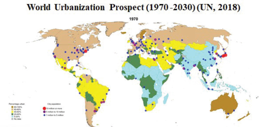
SOURCE: Chunlin Huang, Presentation, National Academies of Sciences, Engineering, and Medicine, December 16, 2019, Washington, DC, based on United Nations, Department of Economic and Social Affairs, Population Division. 2018. World Urbanization Prospects 2018. Available at https://population.un.org/wup/Maps. Accessed April 16, 2020. Licensed under Creative Commons license CC BY 3.0 IGO.
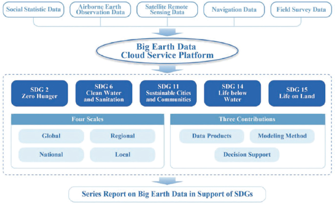
Dr. Huang described efforts by the Chinese Academy of Sciences’ Big Earth Data Science Engineering (CASEarth) program, whose mission is to build the world’s leading big Earth data-sharing platform to monitor and assess selected indicators relating to SDGs 2 (zero hunger), 6 (clean water and sanitation), 11 (sustainable cities and communities), 14 (life below water), and 15 (life on land). Figure 5-2 provides information about the CASEarth structure and work.
One CASEarth project, said Dr. Huang, is examining the proportion of the population with easy access to public transportation in China. The project is using computational methods that extract data related to public transport (transit, subway) and calculate the proportion of the population that has convenient access within the urban built-up area, among other data. The analysis indicated that the proportion of the population with convenient access to public transportation at the provincial level was 64.28 percent on average. Also, at the prefecture-level city scale, the proportion of the population having convenient access to public transportation in densely populated cities was generally higher than in sparsely populated cities.
Regarding decision support, Dr. Huang noted that their work is providing support for the comprehensive evaluation of sustainable development in Chinese cities. The report Big Earth Data in Support of the Sustainable
SOURCE: Chunlin Huang, Presentation, National Academies of Sciences, Engineering, and Medicine, December 16, 2019, Washington, DC.
Development Goals in 2019,1 which was recently released, is an important contribution toward the 2030 Agenda for Sustainable Development. The report includes 12 case studies centered on the 11 SDG indicators within five selected goals and covers the perspectives of data, methods and models, and decision support at local, national, regional, and global scales.
DATA GAPS AND URBAN EXPANSION IN CHINA
Weiqi Zhou, professor of urban ecology at the Research Center for Eco-Environment Studies, Chinese Academy of Sciences, emphasized that urbanization in China has large spatial variations, still mostly occurring in certain regions on the east coast. The concentration of urban expansion in certain regions has resulted in the emergence of urban megaregions. Existing cities, expanding suburbs, and new urban settlements and infrastructures have been gradually woven into urban megaregions. These megaregions concentrate on population and economic activities.
According to the National New-Type Urbanization Plan, China’s first official plan on urbanization released in 2014, the urban megaregion or urban agglomeration will be the main type of urban spatial form over the next decade, said Dr. Zhou. China has planned to invest heavily in facilitating the formation and growth of urban megaregions. More unplanned urban megaregions will be emerging and expanding in the coming decades.
Although the social and economic challenges and opportunities of urban megaregions have been widely discussed, little is known about the potential ecological risks of such massive, spatially connected land of development, Dr. Zhou said. With the emergence of urban megaregions, environmental problems at the city scale expanded to the regional level and gradually became regional issues, such as air pollution and urban heat island effect.
While many studies discuss urban expansions, much less is known about the social and ecological consequences of internal dynamics, stated Dr. Zhou. Internal city dynamics may include ecological challenges such as loss of native species, noise pollution, and temporally increasing air pollution. Such changes also provide enormous opportunities to introduce sustainable technologies and practices to make the city greener, more livable, resilient, and energy and resource efficient.
__________________
1 Chinese Academy of Sciences. 2019. Big Earth Data in Support of the Sustainable Development Goals. Available at https://www.fmprc.gov.cn/mfa_eng/topics_665678/2030kcxfzyc/P020190924800116340503.pdf. Accessed March 9, 2020.
Dr. Zhou discussed data gaps, noting that there is currently an overabundance of data, but much of the data has not been converted to information that can inform policy change. For example, there is extensive Earth observation data that has been archived and collected daily; however, one of the challenges is how to convert these data to inform decision making. There are significant amounts of biophysical data, but a lack of social-economic data, especially at the finer level. In some places where the population exceeds 1 million, only one indicator exists to gauge socioeconomics.
Dr. Zhou said that policy makers need more actionable knowledge that is immediately relevant and easy to use to inform science-based policies, particularly at the local scale. There is a need to move beyond transdisciplinary knowledge to co-production by working together with managers and decision makers to co-develop new science and tools for urban sustainability (see Figure 5-3).
LESSONS FROM THE EARTH FROM SPACE INSTITUTE’S INAUGURAL SYMPOSIUM
Miguel Román, founding director of the Earth from Space Institute (EfSI), an independent program of the Universities Space Research Association (USRA), noted that many of the primary challenges in managing rapid urbanization—from ensuring adequate housing and infrastructure to support growing populations, to confronting the environmental impact of urban sprawl, to reducing vulnerability to disasters—are exacerbated by a dearth of information tailored to the challenges and needs of cities. For decades, urban researchers in the United States have had little input in driving the programmatic priorities of earth science research on sustainability issues. For instance, the 2017–2027 Decadal Survey for Earth Science and Applications from Space2 placed little emphasis on how to consider the sustainability of urban areas, concentrating instead on the traditional study of urbanization as a land transition. As a result, future satellite observations will continue to monitor urban areas merely as a type of land cover, using space-based data and technology requirements adapted from other disciplines (e.g., agriculture and forestry). To thrive under a changing planet, according to Dr. Román, the earth science community must, therefore, acknowledge the unique data and information needs of
__________________
2 See https://sites.nationalacademies.org/DEPS/ESAS2017/index.htm. Accessed March 9, 2020.
SOURCE: Weiqi Zhou, Presentation, National Academies of Sciences, Engineering, and Medicine, December 16, 2019, Washington, DC.
cities and consider alternative solutions that drive scientific progress toward urban sustainability.
Dr. Román also discussed that a second challenge for the earth science community is providing timely data to settlements on disaster risk reduction. Three sustainable development goals are related to disaster risk reduction (SDG 9 on infrastructure, SDG 11 on cities, and SDG 13 on climate action). In disasters, earth science data have focused on describing the hazards themselves but have done little to help communities reduce their risk and bolster their resilience. Dr. Román commented that in the United States, disaster risk management is addressed in a reactive manner—“We wait for things to break and then we try to fix them,” he said. He also discussed how, in disaster situations, the data available are not useful if not contextualized and packaged in a timely manner, especially during rapid and needs-based assessments.
A recent USRA EfSI symposium, Making Communities More Resilient to Extreme Flooding held on October 30–31, 2019, focused on issues related to disaster risk management with 160 attendees from 95 organizations.3 Dr. Román reported some key themes of the symposium included: (1) discussing how to improve communication across sectors; (2) considering flooding as an integrated system, including nature-based solutions in the context of flood risk management; (3) using visualization as an aid to improve perceptions of flood risks; (4) finding the right data and applying them; and (5) strengthening community resilience through public–private partnerships. During a breakout session on flood risk management in rapidly urbanized areas, participants discussed that investing in space-based data and analytical tools that could inform local action was urgently needed, Dr. Román added.4
Dr. Román discussed how, although sustainability is a good target in theory, survivability is often the focus on the ground. While the United States and China have resources to allow decision makers to think about how to adapt cities to better deal with a weather disaster, poorer regions (e.g., Small Islands and Developing States) often do not have that luxury. Citizens are not thinking about long-term adaptation. They have to rely on
__________________
3 See symposium program and summaries at: https://www.usra.edu/efsi-2019symposium. Accessed March 9, 2020.
4 Related reading includes: Stokes, E. C., and K. C. Seto. 2019. Characterizing urban infrastructural transitions for the Sustainable Development Goals using multi-temporal land, population, and nighttime light data. Remote Sensing of Environment 234:111430. https://doi.org/10.1016/j.rse.2019.111430.
informal systems of disaster response and aid both as a life-saving resource and as a community-building resource.
One takeaway from the October symposium, he related, was how important it is to bring the media to the table to learn how to communicate and improve public perceptions of risk. Dr. Román described how the media have begun to shift in discussion of disasters. For example, in the field of broadcast meteorology, the focus is often on describing a hazard-based assessment of hydrometeorological variables (e.g., rainfall, pressure, and wind speed), as well as short-term impacts. But increasingly, meteorologists are building a longer-term narrative about weather patterns: linking disasters to climate change, discussing the increasing frequency of events, tracking a disaster’s sustained damage over time, and its distributional impacts. In journalism terms, he noted they are discussing “who” has been most affected, “what” is the capacity of the affected communities to cope, and “where” to send aid.
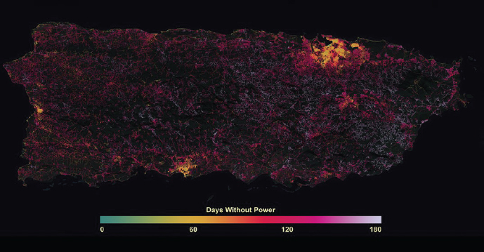
These kinds of questions are also increasingly included in scientific studies of disasters. For example, in Puerto Rico, scientists used satellite-derived estimates of outdoor illuminations to track the number of days without electricity following Hurricane Maria in 2017 (see Figure 5-4)5 and to understand why some communities shouldered longer-term impacts than others. Dr. Román illustrated with the example of Puerto Rico that data on electricity restoration could help inform the U.S. Federal Emergency Management Agency and the Department of Housing and Urban Development about where to direct recovery funds to address the most underserved communities. These are the kind of relevant data that can be used to inform a needs assessment.
Nongovernmental organizations (NGOs) also need to improve their assessment and communication of distributional impacts from major disasters. The symposium’s discussions highlighted that NGOs have a very small time window to seek out emergency financial assistance, Dr. Román said. As such, there is a need for near-real time data that can enable NGOs to better visualize and communicate the conditions of underserved communities on the ground. Dr. Román added that his organization is coordinating with entities that are distributing resources and life-saving supplies
__________________
5 Román, M. O., E. C. Stokes, R. Shrestha, Z. Wang, L. Schultz, E. A. S. Carlo, Q. Sun, B. Jordan, A. Molthan, V. Kalb, C. Ji, K. C. Seto, S. N. McClain, and M. Enenkel. 2019. Satellite-based assessment of electricity restoration efforts in Puerto Rico after Hurricane Maria. PLoS One 14(6): e0218883. https://doi.org/10.1371/journal.pone.0218883. Accessed March 9, 2020.
SOURCE: Miguel Román, Presentation, National Academies of Sciences, Engineering, and Medicine, December 16, 2019, Washington, DC.
(e.g., in the aftermath of Hurricane Dorian in the Bahamas).6 They are also examining how to close data gaps through mapping, as well as how space-based data can be used to improve coverage, for example, in Haiti where there is little information on settlements, roads, and infrastructure mapped before an event.7
Dr. Román also discussed the status of the U.S. National Flood Insurance Program (NFIP),8 which is up for congressional reauthorization. Traditionally, the program has incentivized individuals and developers to build in hazardous areas. He believes that ongoing policy discussions need to take place to revamp the NFIP and offer sustainable solutions that are ready to be scaled up and replicated across disaster-afflicted communities, both on the coast and inland.
__________________
6 See https://www.washingtonpost.com/weather/2019/09/13/dorians-wrath-satelliteimagery-shows-northwestern-bahamas-dark-after-disastrous-storm. Accessed March 9, 2020.
7 Goldblatt, R., N. Jones, and J. Mannix. 2020. Assessing OpenStreetMap completeness for management of natural disaster by means of remote sensing: A case study of three small island states (Haiti, Dominica and St. Lucia). Remote Sensing 12:118. https://doi.org/10.3390/rs12010118. Accessed March 9, 2020.
8 See https://www.fema.gov/national-flood-insurance-program. Accessed March 9, 2020.
DISCUSSION
Participants discussed a number of issues related to the use of earth observations to support decision making. For example, related to post-disaster and recovery scenarios, there is a need to incorporate satellite-derived data to communicate the compounding risks of disasters effectively. Dr. Román noted the need for data to help build social capital internally, empathy externally, and then integrate the data in a way that can be communicated effectively. New satellite missions specifically designed to measure urbanization as a “process,” instead of urbanization as a “place” (i.e., the Urban 2.0 data paradigm), will help stakeholders identify sectoral interlinkages and their implications across economic, social, and environmental areas in implementing the SDGs.
Several participants also discussed the need to communicate with stakeholders and particularly decision makers. Dr. Román added that the outcome of what to communicate needs to be at the right time and spatial scales to be relevant.


