
6
Stream Management Program
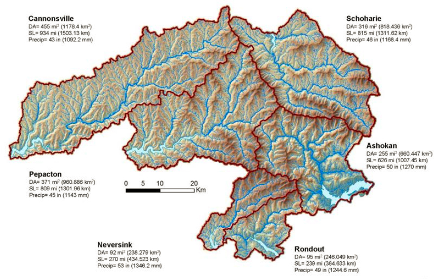
Established in the mid-1990s and now one of the largest of New York City Department of Environmental Protection’s (NYC DEP’s) watershed protection programs (see Table 1-1), the Stream Management Program (SMP) is both a water quality protection and remediation program. One of its primary aims is to reduce suspended sediment transport that leads to high turbidity in west-of-Hudson (WOH) streams and reservoirs. In addition to minimizing erosion and sediment transport that can lower water quality, stream-management efforts have multiple other objectives with benefits to WOH communities and ecosystem integrity, including flood hazard mitigation; protection of roads, bridges, and other public infrastructure; protection of private property; and improvement of aquatic habitat. The area managed is ~1,584 mi2 in six Catskill Mountain watersheds west of the Hudson River (Figure 6-1). With an average of ~2.3 miles of stream per square mile of watershed area, the cumulative stream length for these six watersheds is 3,700 miles.
A network of collaborating partners maintained through the SMP enables local advisory committees from WOH communities to work with county soil and water conservation districts and NYC DEP to develop watershed-scale management plans and to identify stream sites for projects in their communities. Reaches are prioritized for management based on water quality data and the potential for high erosion rates and sediment loads. Management strategies span a range of activities from preservation and passive monitoring to full channel restoration.
INTRODUCTION TO CATSKILLS STREAMS AND STREAM MANAGEMENT
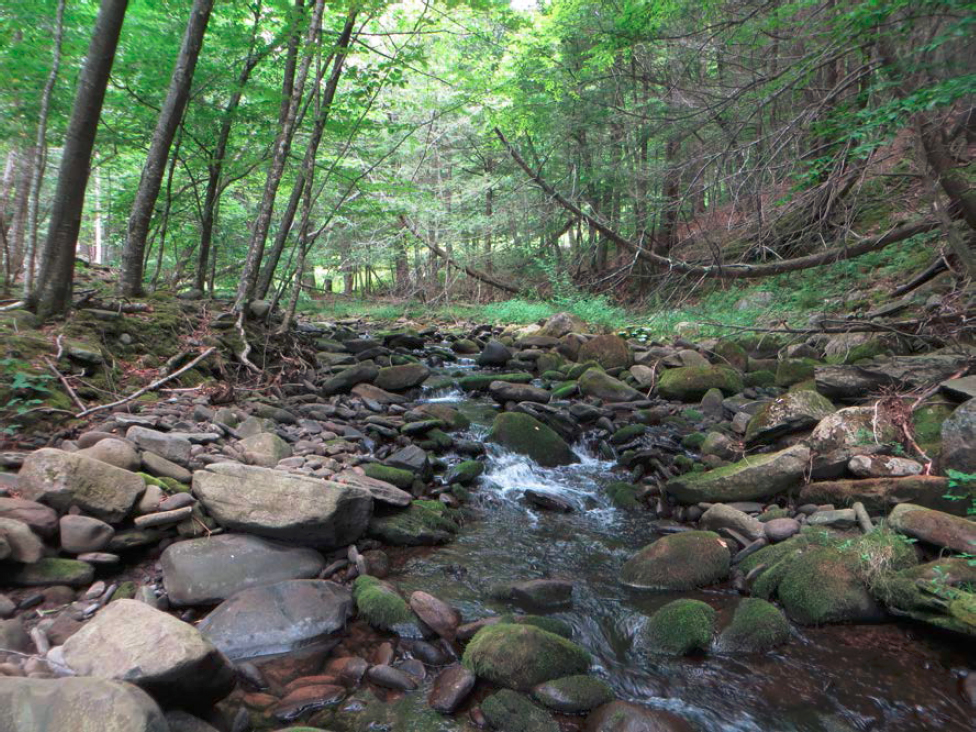
NYC DEP and local partners have the daunting task of managing nearly 4,000 miles of streams and associated floodplains in a region famed for its ruggedness, deep ravines locally called cloves,1 stunning waterfalls, and dense woods (Figure 6-2). It is a landscape romanticized by Thomas Cole in the 19th century with lavish paintings of wild gorges and craggy precipices. This is the land of Washington Irving’s “torrents tumbling” and “savage glens” (Irving, 1851). Catskill streams are renowned for their beauty and recreational opportunities, including fly fishing.
___________________
1 The word “clove” is derived from the Dutch word kloof, which is a notch or gorge in a mountain or ridge. Kloof literally means the cleft of the hoof of an animal, and was used by early Dutch settlers in the region because they thought Catskill ravines resembled cloven hooves.
Streams and Their Histories
Streams are much more than conduits for open-channel flow. They are dynamic systems that transmit and exchange mass (water, sediment, and chemical and biological constituents) and energy along longitudinal, lateral, and vertical pathways of connectivity (Kondolf et al., 2006; Pasternack, 2013; Sear et al., 1994; Vannote et al., 1980). Streams are shaped over time—sometimes immense periods of geologic time—and simultaneously they shape their surroundings. The floodplains adjoining streams, constructed by deposition of sediment and organic matter during overbank flow, are crucial elements of stream systems. They hold water during high flows and recharge groundwater that will sustain stream flow during drier times, and they provide riparian habitat. Hyporheic exchange, the transfer of water and nutrients from streams to adjacent beds and banks and back again during a range of flow conditions, is vital to stream metabolism and ecosystem integrity (Grimm and Fisher, 1984; Merill and Tonjes, 2014; Wondzell, 2011).
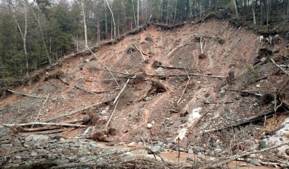
Streams’ recent histories affect their present form and functioning and, as a consequence, their management (Walter and Merritts, 2008; Wohl, 2019; Wohl and Merritts, 2007). As described in Chapter 2, the legacy effects of 19th century land and resource uses—hemlock logging and bark-peeling for tanneries, water-powered sawmills, bluestone quarries, and the extensive road network (typically in narrow floodplains of larger streams) that connected these activities to distant markets—are plainly evident in the Catskills. Signs of stream degradation include clogging of the channel with sediment, channel avulsions, and excessive stream bank and bed erosion. Nineteenth century logging (and wildfires in cut over areas) have led to greater rates of mass movement on hillslopes, road and bridge building along valley bottoms (sometimes burying small streams), and a dearth of large in-stream wood. Numerous other anthropogenic activities can similarly disturb hillslopes and streams, including agriculture and mining. Signs of stream degradation can persist for decades, even centuries, such that diagnosing the causes of instability and degradation can be difficult.
The geologic history of Catskills streams also plays a role in their current management. The power of flowing water and sediment carried in these streams created this rugged landscape through deep dissection (in places up to several thousand feet) into a west-sloping plateau of ancient sedimentary rocks over tens of millions of years. The erosional work of streams in shaping this landscape was aided, perhaps even accelerated, by dozens of advances and retreats of massive ice sheets over the Catskills region during the Pleistocene Epoch, a time of alternating cold and warm conditions from ~2.6 million to 11,700 years ago. A legacy of these ice sheets remains, chiefly in the form of bouldery tills dumped by retreating glaciers and of patches of fine clays trapped in once icy pockets of water that dotted the draining, thawing land each time ice sheets retreated. Geologists refer to the fine clays as glacio-lacustrine in origin because they were deposited in quiet water lakes due to temporary blockages of valleys by glaciers.
This glacial history makes managing Catskill streams daunting. The geologically unusual combination of boulders (high energy) and clays (quiet water) along some bedrock ravines pose challenging conditions for developing stream management and restoration plans. Many of the stream projects completed to date, for example, are at locations where glacio-lacustrine clays have been exposed by recent erosion along stream beds and banks (e.g., Davis et al., 2009; NYC DEP, 2017). Once exposed by channel erosion, these clays can lead to multiple problems, including mass movement (i.e., landsliding) of adjacent hillslopes and high suspended sediment loads and turbidity to downstream waters. Recognizing the significance of these overarching geologic conditions, NYC DEP staff have made it a priority to map glacial tills and clays along Catskill streams, as well as locations of channel instability, to help them pinpoint the stream reaches that are likely the greatest sources of high-turbidity water in the NYC watershed.
Stream Stability and Management
Stream restoration is a primary facet of watershed management. The phrase “stream restoration” is used in a broad sense, following Wohl et al. (2015: 5974), to include various “modifications of river channels and adjacent riparian zones and floodplains…that…share the goal of improving hydrologic, geomorphic, and/or
ecological processes within a degraded watershed and replacing lost, damaged, or compromised elements of the natural system.” This broad meaning includes management and engineering practices that range from local structural modifications, such as bank stabilization, to full channel restoration projects in which new channels and floodplains are created for up to thousands of feet of stream length.
NYC DEP frames the SMP’s mission for stream management as: “Partners working to protect and restore stream system stability and ecosystem integrity by facilitating the long-term stewardship of Catskill Mountain streams and floodplains.” Of significance in this statement is the view that achieving “stream system stability” is a means of managing a stream. Stability for the purposes of NYC DEP stream management refers to a stream for which incision of its bed, erosion of its banks, and/or mass movement along adjacent hillslopes might occur locally and temporarily, but neither process is widespread or persistent. In response to perturbation, for example such as a large flood, a stream channel might adjust to temporary changes in sediment load and gradient; with time, these adjustments might diminish. Continual change might occur, but the net change is limited. This condition for streams is known as “dynamically stable.” Stream stability is not merely a function of channel form; it encompasses a suite of interconnected abiotic and biotic processes that extend across the floodplain and even to the toes of hillslopes, as discussed below.
To illustrate a typical Catskill example, Figures 6-2 and 6-3 show stable and unstable stream reaches, respectively. Unstable reaches are often locations of headcuts, as cited in many NYC DEP SMP project descriptions and mapped in Stream Feature Inventory assessments. Headcuts form when a stream channel cuts down into its bed relatively rapidly, leading to a step in the stream’s longitudinal profile where the channel is steepened. Headcuts tend to cut headward with time as the stream adjusts and lowers the gradient of its bed downstream of the upstream-migrating headcut (see Figure 6-7, bottom photo). This incision, especially if into glacial strata, can initiate other channel adjustments that might lead to excessive erosion and mass wasting from
SOURCE: Ashokan Watershed Stream Management Program (2015).
hillslopes. Although headcuts are relatively easy to identify and map in the field, it is more difficult to determine why they formed in the first place. Typical causes of headcuts identified by SMP staff include channel straightening, dredging and berming channels after flooding, reductions in upstream sediment supply relative to reach sediment transport capacity, and channel obstructions.
Given the Catskills’ generally deep and narrow bedrock valleys in glaciated terrain with steep hillslopes, waterfalls, and glacial tills and clays, one might wonder if Catskill streams had more stable channels and floodplains prior to logging, quarrying, road building, farming, and other land use changes that occurred during the past few centuries. Geologic evidence, modern analogs, and historical accounts indicate that streams and hillslopes can indeed be relatively stable in tectonically inactive terrain similar to that of the Catskills region (Cook et al., 2020; Egholm et al., 2013). More than 10,000 years of mostly warm, humid conditions have passed since the end of the last full glacial episode, and paleoecological research reveals that forests were well established on hillslopes in the region soon after. In general, vegetation on slopes in forested landscapes and the abundance of large in-stream wood promote relatively stable stream systems and floodplain wetlands (Wohl, 2011, 2013). In steeper terrain, such as headwater reaches with greater than 5 percent slope, streams with step-pool morphologies were likely to have existed in the Catskills, whereas in wider valleys with gentler gradients, streams might have had multiple branches of channels that surrounded vegetated islands composed of coarser sediment (Chin and Wohl, 2005; Collins et al., 2012; Kochel et al., 1987, 2016). Many stream restoration practitioners, including those in the WOH region, attempt to determine these “baseline” conditions to identify what types of streams and floodplains were relatively stable prior to the anthropogenic disturbances of the past few centuries.
Despite widespread upland forest recovery in the Catskills since the early 20th century, parts of some streams and lower parts of hillslopes are clearly unstable at present (or were until stream management projects were implemented recently), and some of these unstable reaches are sources of high turbidity (see Figure 6-3). The Committee’s review of dozens of sites for Catskill stream management projects suggests that modern causes of instability are closely linked to channel relocations and realignments associated with numerous roads, bridges, and railroads that crisscross valley bottoms, as well as other anthropogenic disturbances that alter sediment supply and runoff. Mulvihill and Baldigo (2012) describe historic channel manipulations after flooding in the Catskills that included channel dredging and construction of rock walls and berms (i.e., post-flood dredging and berming); filling of floodplains; and not only the straightening but also the widening and deepening of channels.2 Although some probably thought that these procedures might reduce the effects of future flooding, it is highly possible that they led to further stream instability. NYC DEP staff recognize these problems (e.g., Davis et al., 2009), and strives to find ways to achieve stream stability despite the overlay of modern infrastructure and history of channel modifications along stream corridors.
For a stream restoration project to be successful, the root cause of instability must be determined and addressed so that the restored channel can be resilient through a range of design flows (Small and Doyle, 2012). This determination requires a watershed- and reach-scale assessment to define controlling factors (Beechie et al., 2010; Roni et al., 2002). Treatment then entails addressing the cause of instability as well as constructing a more stable, well-connected channel-floodplain system. For the past two to three decades, scientists, engineers, and restoration practitioners have grappled with how to restore degraded stream systems in ways that can achieve stable streams (i.e., threshold design channels) that are more natural and resilient to a range of flows. Failure of a designed stream channel (e.g., continued excessive bank and bed erosion) can have substantial costs, both in dollars and consequences to humans and the environment.
Approaches for Designing Stream Restoration Projects
The foundations of modern fluvial geomorphology established during the 1950s to 70s identified quantitative relationships—particularly empirical regressions—among drainage area, streamflow, channel forms, and sediment transport that have been incorporated into strategies for stream restoration since the 1980s (Dunne and Leopold, 1978; Leopold et al., 1964; Shields et al., 2003; USDA NRCS, 2007). This work continues, with
___________________
2 See photos of such historic practices from Stony Clove landowners at http://www.catskillstreams.org/pdfs/stonyclovesmp/historic_photos.pdf.
regressions for hydraulic geometry relationships developed across North America, including in the Catskills (Castro and Jackson, 2001; Miller and Davis, 2003; Mulvihill and Baldigo, 2012).
Many stream management projects in the United States have been developed using an approach to stream restoration known as natural channel design (NCD) (Hey, 2006; Rosgen, 1994, 1996, 2007). Through manuals and training, Rosgen developed a simplified lingua franca to communicate complex ideas about streams and restoration. Nonetheless, the scientific literature and public documents for the past approximately 25 years reveal a struggle to agree upon approaches to restoration design (some representative examples can be found in Juracek and Fitzpatrick, 2003; Lave, 2009, 2012, 2016; Malakoff, 2004; Simon et al., 2005). Rosgen (1996, 2007) based his restoration framework on observations of what were thought to be natural channels, with the goal of reestablishing natural geomorphic and hydrologic processes through channel restoration. The three basic elements of this approach are (1) classifying stream channel form to assist in the selection of an analog reference stream and application of regional curves, (2) using dimensionless geomorphic measures based on bankfull stage to design plan and profile dimensions, and (3) using in-stream structures to prevent excessive erosion and enhance habitat. Based on geomorphic equilibrium concepts and the hydraulic geometry relations described by Leopold and others (see above), Rosgen developed a system to classify rivers based on five metrics: their valley type (entrenchment ratio), planform patterns (sinuosity), longitudinal slopes, width-depth ratios, and type of sediment in their beds. In NCD, a reference stream site and these five metrics are used to appropriately size a channel in order for it to carry the channel-forming (bankfull) flow and sediment loads.
The NCD methodology relies upon determining the bankfull morphology of reference reaches that are deemed stable and located in the same type of valley setting as the channel to be restored. It also requires some data on the relations between bankfull discharge and the hydraulic geometry of channels. SMP staff and partners have collected data in the field for many years in order to build regional curves for the hydraulic geometry of WOH streams spanning a wide range in drainage areas and discharges (Miller and Davis, 2003; see also discussion in Mulvihill and Baldigo, 2012). Bankfull discharge is widely used in stream restoration practice because it is considered to be equivalent to the channel-forming discharge (Lawlor, 2005; Leopold et al., 1964). Bankfull discharge also represents the flow capable of carrying the largest sediment load over time as effective discharge (Dunne and Leopold, 1978; Emmett and Wolman, 2001). Finally, it is assumed that dominant discharge equates to effective and bankfull discharges, and it occurs when a stream system is stable within the context of a geomorphic dynamic equilibrium and is able to move the majority of sizes of particles in gravel-bed streams (Andrews and Parker, 1987; Leopold and Rosgen, 1991; Lisle et al., 2000). Furthermore, NYC DEP has shifted from using bankfull discharge only to a full range of flows, from low to 100-year events, in its more recent restoration work.
Stream restoration methods have expanded beyond NCD by using hydraulic, sediment transport, and mesohabitat models (Johnson et al., 2002; Niezgoda and Johnson, 2006; Schwartz et al., 2015; Schwartz, 2016; Shields et al., 2003; Slate et al., 2007). With the use of hydraulic engineering models, channel dimensions can be computed directly for the specific location and reach to be designed. In addition to the use of hydraulic models, other approaches have been developed such as the modified hydraulic geometry approach by Copeland et al. (2001). The NYC DEP has contracted with engineering firms that have used an engineering approach using the HEC-RAS model (U.S. Army Corps of Engineers’ Hydrologic Engineering Center River Analysis System) for restoration design (as in the Stony Clove Creek example below), particularly when channel repair is required near a bridge or other critical infrastructure. NYC DEP’s use of multiple approaches, including the NCD approach and hydraulic engineering models, reduces the risk of project failure for objectives such as channel stability and prevention of erosion of clays.
PROGRAM DESCRIPTION
The SMP has many components, including stream management plans and projects (those that focus on stream channels), efforts to revegetate riparian areas including the Catskill Streams Buffer Initiative (CSBI), and more recent efforts to carry out local flood hazard mitigation projects. These key components, along with rele-
vant partners and participants, are listed in Table 6-1 and described below. While NYC DEP provides an overarching framework for the SMP, including leading and funding many of the program’s activities, partnering agencies and other participants are critical to implementation, including county soil and water conservation districts from Greene, Delaware, Sullivan, and Ulster counties, the Cornell Cooperative Extension of Ulster County, the U.S. Geological Survey (USGS), and watershed counties and towns. Environmental and community organizations, riparian landowners and community members are involved in stream stewardship through their participation in the development of stream management plans, local flood assessments, education and outreach, and stream projects.
The SMP’s multi-party, collaborative approach brings together key stakeholders and actors and allows each to contribute their unique knowledge and capacities. Notably, these entities also engage in activities that contribute to stream stability and health independent from the SMP. For example, county and town public works departments conduct infrastructure maintenance and improvements at river crossings. Counties, Towns and landowners partner with the U.S. Department of Agriculture Natural Resource Conservation Service (USDA NCRS) to implement stream restoration and rehabilitation projects. Businesses and land owners construct or rehabilitate streams on their properties. This multiparty approach also means that it can be difficult to attribute activities and outcomes specifically to the SMP and that, at times, stream management activities are not coordinated in a manner that maximizes their potential protection of and enhancement to water quality.
From 1993 to 2018, the SMP has received $220 million (NYC DEP, 2019a) to plan, implement, and monitor nearly 400 projects of six different types (Figure 6-4) along more than 40 miles of streams in WOH watersheds (Figure 6-5). Most projects are riparian buffers (230), followed by full channel restorations (60) and streambank
TABLE 6-1 Components of the Stream Management Program and Participants
| Stream Management Program Component | Participants |
|---|---|
| Stream management plans |
New York City Department of Environmental Protection (NYC DEP) Soil and water conservation districts (SWCD) U.S. Geological Survey (USGS) Watershed counties and towns Other organizations involved in stream stewardship Community members |
| Stream projects |
NYC DEP USGS Watershed towns Riparian landowners U.S. Department of Agriculture Natural Resource Conservation Service Emergency Watershed Protection Program |
| Stream Management Implementation Program |
NYC DEP Watershed counties and towns Watershed advisory committees (community members) Streamside landowners Other organizations involved in stream stewardship |
| Flood Hazard Mitigation Program |
NYC DEP Watershed counties and towns |
| Catskill Stream Buffer Initiative |
NYC DEP SWCD Landowners |
| Outreach and education |
NYC DEP SWCD Catskill Environmental Center Other organizations involved in stream stewardship |
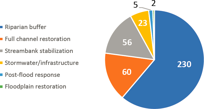
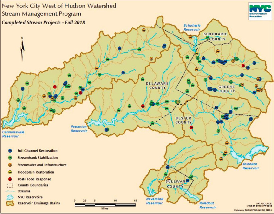
stabilizations (56). In addition, 16 stream management plans were completed and adopted by local communities in order to implement these projects.
Stream Management Plans and Stream Projects
Fundamentally, the SMP aims to reduce fine sediment (and thus reduce turbidity) in WOH waterways via restoration practices that target the most likely sources of sediment. These tend to be where stream channels are unstable and eroding into glacio-lacustrine silts and clays (Cornell Cooperative Extension of Ulster County, 2007; Davis et al., 2009). High turbidity from fine sediments in the WOH system, particularly after large-magnitude precipitation events (see Table 1-1 and Chapter 4), challenges the ability of NYC DEP to meet the turbidity requirements of the Surface Water Treatment Rule at Kensico Reservoir.
The general workflow to achieve the desired outcomes of less fine sediment and lower turbidity in WOH streams through stream management plans and water-quality-driven stream projects is as follows:
- Establish priorities for the watersheds most in need of stream management projects;
- Establish and maintain partnerships with local stakeholders;
- Work with partners to map stream corridors (Stream Feature Inventories) and develop stream management plans for each watershed;
- Use the stream management plans to prioritize stream reaches where channels are unstable and sources of fine sediment (and probably high turbidity) or, in some cases, where there are concerns with flooding, disconnected floodplains, undersized culverts or bridge crossings, and other issues;
- Plan and design site-specific stream projects (often referred to as “stream sediment turbidity reduction projects” or STRPs) to achieve more-stable conditions and to treat the underlying causes of channel instability, thereby reducing the transport of suspended sediment;
- Mitigate high-priority reaches through implementation of STRPs and/or flood mitigation projects;
- Monitor the projects and stream reaches so as to determine the effectiveness of remediation efforts, including before and after monitoring and upstream and downstream monitoring;
- Analyze monitoring data to estimate the effectiveness of individual or groups of STRPs; and
- Adapt future planning and project implementation to lessons learned from previous steps in the workflow.
The Committee supports the adaptive management approach embodied in the bulleted steps.
Until 2007, much of the work of the SMP was related to establishing partnerships with various agencies and groups in WOH watersheds, coordinating training of staff at NYC DEP and partner agencies such as county soil and water conservation districts, developing a better understanding of streams in the region, mapping stream corridors, locating areas of channel instability through stream assessments, and planning for projects through development of stream management plans. Since then, program efforts have shifted to a much greater focus on project implementation, as well as to more targeted scientific investigations designed to identify sources of highest turbidity and evaluate effectiveness of restoration practices.
The NYC DEP has allocated substantial resources over the past ~20 years to identify the sources of suspended sediment that can lead to high turbidity in streams throughout the Catskill region. Early studies revealed that fine sediment was derived mostly from erosion of stream beds and banks at locations where streams were unstable and, in particular, where streams had eroded into glacio-lacustrine silts and clays (Cornell Cooperative Extension of Ulster County, 2007; Davis et al., 2009; Effler et al., 1998; Peng et al., 2002, 2004; McHale and Siemion, 2014). These studies identified Upper Esopus Creek as the most significant watershed delivering high-turbidity water to the NYC reservoirs. The study of sediment sources (Nagle et al., 2007) established the utility of isotopic techniques to distinguish between land-surface erosion versus bank erosion. The USGS monitoring study of 14 subwatersheds during 2010 and 2011 identified Stony Clove Creek as the largest contributor of the sediment loads of the Upper Esopus Creek (McHale and Siemion, 2014). This monitoring information was important to the prioritization of STRPs in the watershed.
To establish the best options to manage the high-turbidity problem (focused on the Ashokan Reservoir), NYC DEP considered upland landscape-based erosion control efforts and concluded that these efforts would likely be unable to significantly reduce the turbidity problem. The major conclusion that NYC DEP reached is stated in the Executive Summary of their report (NYC DEP, 2008). It is worthwhile to quote these conclusions in full here, because they form the basis for the whole set of actions that have been underway since that report was issued.
The Stream Management Program has the greatest possibility of producing an impact on reducing delivery of turbid water to Ashokan Reservoir by potentially reducing in-stream erosive contact with clay and silt sources. In some instances, where there is room for proper alignment, implementing some grade control and the use of bank stabilizing measures with rock and vegetation, a stream segment may be removed from the geologic fine sediment source, although fine-grain sediment in the stream bed material will persist. In other cases, the stream erosion is into a massive hill slope composed of clay-rich deposits that continually slide into the stream, and there is little room for realignment of the stream away from the unstable hill slope. The conditions are varied and the challenges numerous for addressing sediment loading in streams through stream restoration. NYC DEP believes that the Stream Management Program effectiveness can be enhanced by emphasizing coordinated response to flood events to minimize subsequent damage, investing in protecting and improving riparian buffers, and extending the current state of knowledge on best stream management practices to all who “manage” streams.
Fundamentally, it is unlikely that the Watershed Management Programs will reduce the impact of extreme floods on prolonged turbidity levels in Ashokan Reservoir. These overwhelming events, in contact with a ubiquitous geologic turbidity source, impact the quality of Ashokan Reservoir for extended periods of time. Yet, cumulatively and over time, these programs are expected to have a measurable impact on reducing turbidity for other flow conditions and hopefully reducing the prolonged impact of the big floods by creating a more resilient stream system and minimizing damaging post-flood activities that can do even more damage than floods to destabilize the stream system. Similarly, the protection programs contribute significantly, if not quantifiably, to avoiding new or expanded contributions of turbidity within the watershed.
The Committee agrees with the general thrust of this conclusion, realizing that such a plan of action is not a panacea but has the potential to bring about significant improvement of the situation. The Committee endorses NYC DEP efforts to pursue this agenda in an adaptive management approach, involving action, monitoring, data analysis, and feedback to improving their efforts over time.
Stream Management Plans
Stream management plans characterize the condition of streams, prioritize reach-scale water quality threats, identify basin priorities and schedules, and build a foundation for action. They are essential for identifying chronic and emergent problems along stream corridors, and for prioritizing reach-scale water quality threats. For example, stream management plans for Beaver Kill3 and Stony Clove Creek4 identified reaches that were persistent sources of sediment and high turbidity; this information then guided the targeting of sites for remediation and monitoring. Relevant communities and watershed advisory councils formed during the planning process are consulted extensively as stream management plans are developed, and final plans are reviewed by municipalities for adoption.
Numerous aspects of streams and their watersheds are considered during GIS and field-based assessments that form the basis of Stream Management Plans, including geomorphology, hydrology, human and land use history, riparian condition, and the record of flooding. Data from field assessments is incorporated into Stream Feature Inventories. These are geodatabases for multiple types of stream features that are identified
___________________
3 See https://ashokanstreams.org/exploring-the-watershed/beaverkill-2/.
4 See https://ashokanstreams.org/exploring-the-watershed/stony-clove-creek/.
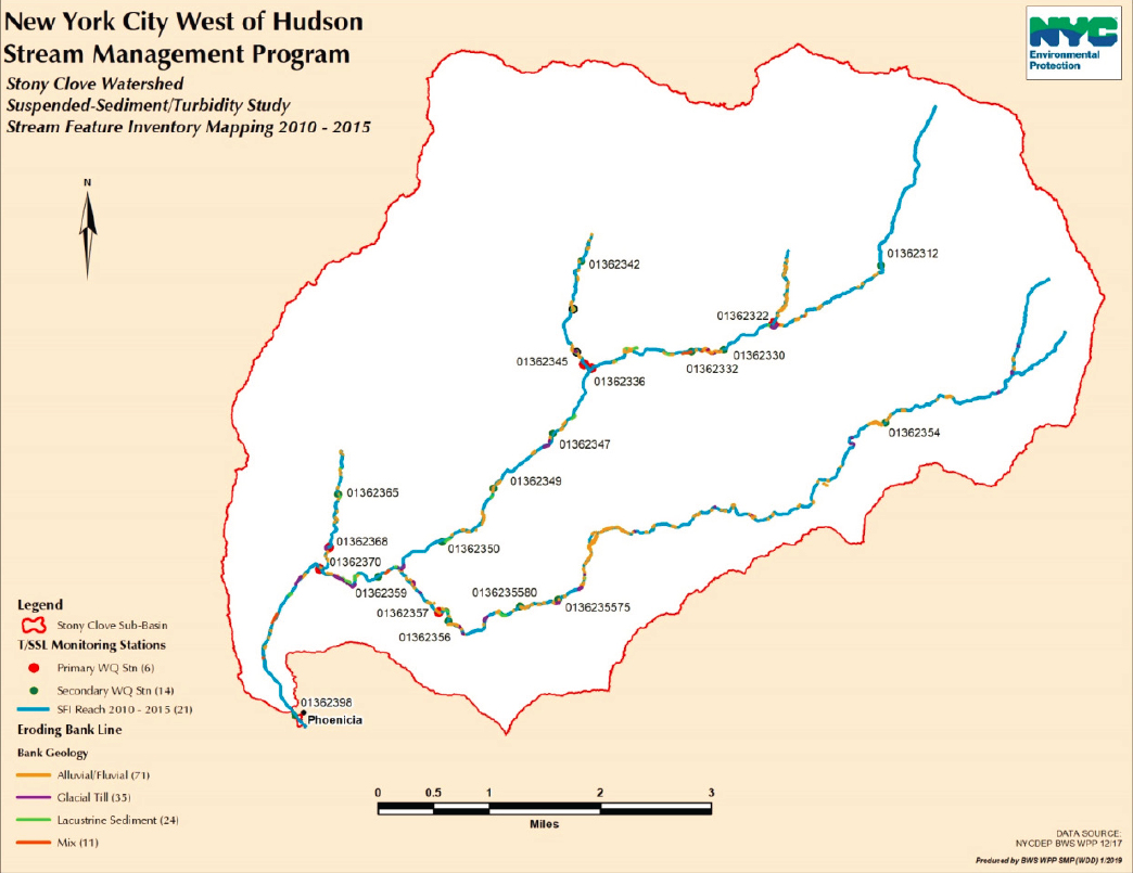
and mapped with GPS survey technology in the field. Features include eroding banks and hillslopes, infrastructure (e.g., berms, bridges, and culverts), invasive species, large wood jams, degraded riparian buffers, and bedrock grade controls along stream channels. The locations and attributes of these and other key features are entered into a GIS geodatabase of stream feature types. An example of a stream inventory map for stream bank erosional suspended-sediment sources in the Stony Clove sub-basin is shown in Figure 6-6.
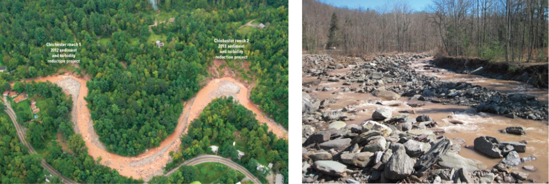
Stream management plans refer often to locations and causes of channel instability. The Plans indicate that unstable reaches, including those with headcuts, commonly are located where stream channels are aligned along valley margins, cutting into steep hillslopes, and tend to be most severe where streams have incised into fine glacio-lacustrine sediments (see Davis et al., 2009). For this reason, mapping the geologic materials in detail along stream corridors and banks has been a key part of the SMP in the WOH region. In general, instability often is associated with modified hydraulics near infrastructure (such as bridges and culverts) —both its presence and failure—that has been built up along valley bottoms since European settlement. At the Chichester site on Stony Clove Creek (Upper Esopus Creek watershed) shown in Figure 6-7, for example, Davis et al. (2009) reported that this area had a “long history of modification, including development and construction of a railroad line … and various efforts to control the creek channel alignment” (p. 8.17). The Upper Esopus Creek Stream Management Plan Volume I notes that for the Upper Esopus there are “238 existing streamside
landowners along its course, more than nine miles of roads and many more miles of railroad within 300 feet of the channel, and 19 bridge crossings” (Cornell Cooperative Extension of Ulster County, 2007: p. 37). Sometimes channel instability is described in various reports as the result of infrastructure encroachment and valley confinement, with both referring to the reduction in floodplain area over which high water can spread during large-magnitude flow events.
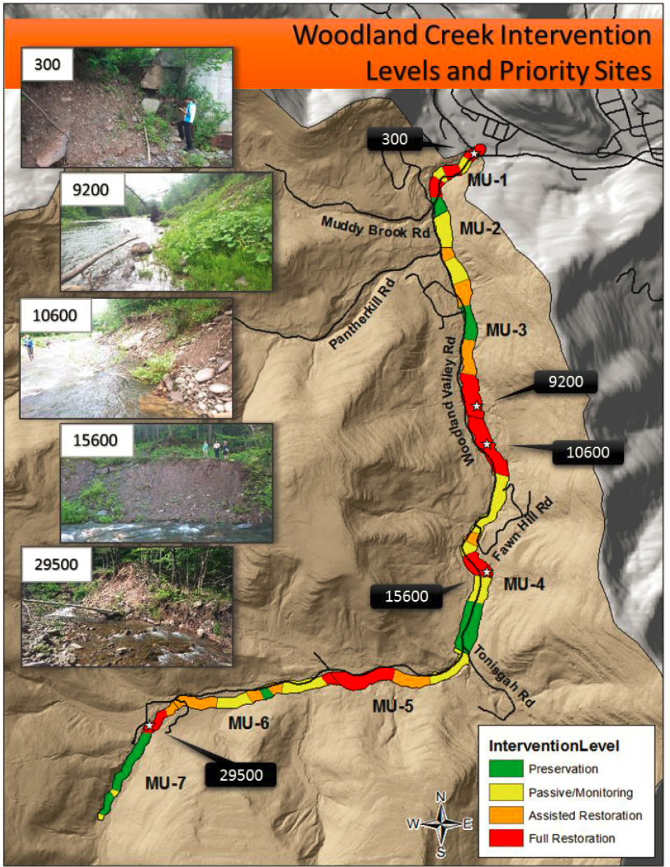
In addition to identifying areas that need further assessment and monitoring, stream management plans identify the level of intervention necessary at each site as a tool to communicate with residents and local municipal officials regarding the relative condition of various stream reaches, and the relative priority for management. Four intervention levels exist, from the highest for full channel restoration, to assisted restoration, to passive restoration with monitoring, and finally the least intervention for preservation. These four levels of effort can exist simultaneously on the same river (Figure 6-8).
Stream Projects
Once stream management plans are created, stream projects can be implemented, (see Figure 6-4; Box 6-1). Generally, these projects are water-quality driven and treat or prevent sources of impairment that are identified in Stream Feature Inventories and monitored through bank erosion surveys. However, since 2009 the SMP has also funded community-driven projects that do not necessarily have improvement in water quality as their primary goal.
As shown in Figure 6-4, the six types of projects range from local bank stabilization to floodplain restoration and full channel stability restoration in which new channels are created along substantial lengths of a stream. Enhancement of riparian buffers are by far the most commonly used project type. These four project types are primarily used to achieve water quality goals in their adjacent streams. The two other project types are stormwater and infrastructure control structures and post-flood remediation work—projects that are often community driven. Many stream reaches have benefitted from more than one type of project.
The primary focus of stream projects in the Ashokan, Schoharie, Rondout, and Neversink basins is turbidity reduction, typically treated with bank stabilization, full-channel restoration, and floodplain restoration. For example, of ten projects completed as of 2018 along Stony Clove Creek (84 km2), eight are full channel stream restorations and two are streambank stabilization projects. Some of these projects also incorporated elements of post-flood-response/floodplain restoration and stormwater and infrastructure improvement. The concern in the Cannonsville and Pepacton basins is nutrient-laden sediments, typically treated with practices similar to those for turbidity reduction, but also more riparian buffers.
Streambank and Hillslope Stabilization.
For bank stabilization, bankfull elevation benches and riparian plantings commonly are used; in extreme cases of erosion, retaining walls are built and banks are armored with rock (e.g., Schoharie Creek project in the town of Hunter). Reducing or eliminating hydraulic erosion at the toe of the streambank to prevent over-steepening and/or undercutting is considered the best approach to prevent bank mass failure. To stabilize hillslopes, slopes are regraded to more stable configurations, and surface and subsurface drainage systems are installed or modified. These geotechnical approaches for hillslope stability can be effective to slow mass movement and reduce sediment supplies from hillslopes.
Floodplain Restoration.
NYC DEP SMP recognizes the value of floodplain restoration and in particular of reconnecting streams with floodplains. Floodplain connection has multiple benefits including reducing the risk of bank erosion by limiting channel boundary shear stresses, improving water quality by providing space for sediment deposition, and creating hydrologic connectivity for a healthy lotic ecosystem. It is generally accepted by those who practice and evaluate stream restoration projects that a stable stream with high floodplain connectivity is more likely to have the capacity to store floodwater and fine sediment on the floodplain through overbank flow and deposition than a stream with little or limited floodplain connectivity (e.g., one that is incised). Many of the SMP’s recent stream projects refer to reconnecting floodplains in addition to creating newly shaped stream channels. An example is the Vly Creek floodplain restoration project in the East Branch Delaware watershed, in which 4,500 cubic yards of material were removed in order to reconnect the stream and floodplain, providing possible flood hazard mitigation benefits, along 525 feet of stream in 2018.
Riparian Buffers.
As introduced in Chapter 4, protection and restoration of riparian areas is a foundational component of any watershed protection program, and it can be one of the most cost-effective ways to maintain or enhance water quality in streams. Program managers work with private landowners to stabilize riparian areas by planting site-adapted trees and woody shrubs. Over time, as this riparian forest vegetation grows and matures, it restores the structural features, ecological functions, and protective values described below.
A full accounting of the water quality and other benefits of functioning riparian areas is beyond the scope of this document (see NRC, 2002, and de la Crétaz and Barten, 2007, Chapter 5 for thorough analyses). Nonetheless, the most significant functions of riparian areas in the context of the SMP are described here. First, the extensive roots of riparian vegetation protect and bind the soil and maximize the opportunity for nutrient uptake. This uptake transforms potential pollutants (nitrogen and phosphorus) into plant biomass. Annual leaf fall and herbaceous plant senescence return these nutrients to the soil as organic matter. This annual addition enhances soil fertility and water-holding capacity and encourages more plant growth and pollutant uptake.
With respect to the role of riparian areas in reducing sediment loading to streams, trees and other vegetation provide essential root support and inhibit mass erosion, which is particularly important on steep slopes and the meander bends in streams. If the riparian area is well protected by leaf litter, woody and herbaceous plants, and woody debris, its high infiltration capacity and surface roughness limit or eliminate overland flow during rain and snowmelt events. As a result, suspended sediment and organic matter (and adsorbed nutrients) are stranded on the surface and quickly incorporated into the soil.
Riparian vegetation casts shade over the first-order and second-order streams that comprise much of the Catskill Mountain drainage network. This shade limits the daily and seasonal fluctuation in water temperature. Finally, over the long term, riparian vegetation is the source of the woody debris (ranging from large logs
to small branches and transient leaf packs) that dissipates energy, fosters bank and channel stability, promotes aeration, and enhances aquatic habitat quality as water cascades down a stair-step sequence of small pools and riffles. Large wood that falls into the stream channel not only adds carbon to the ecosystem, but its structure regulates sediment transport and the formation of pools and riffles. Pools and riffles are essential to stream ecosystems because so many aquatic organisms have evolved to explicitly use one or the other (Aadland, 1993; Clifford et al., 2006; Schwartz and Herricks, 2008).
Full-Channel Restoration.
For full-channel restoration projects, in general NYC DEP and the engineers contracted to do the work have used approaches based on Rosgen’s NCD, although with time they have tailored their approach to site-specific conditions and lessons learned from prior projects. Their approach focuses on stream channel form and function (hydraulics and sediment transport) and incorporates hydraulic modeling, whereas a conventional approach to Rosgen’s NCD focuses more on replication of channel dimensions based on stream classification and a reference condition. Adding the focus on stream function, as well as more attention to floodplains during restoration, is in line with current scientific consensus that successful outcomes in stream restoration are more likely with a process-based approach to restoration, rather than solely a form-based approach (Pasternack, 2013). The SMP staff cites multiple advantages to using an approach based on NCD. Prominent among them is an ability to communicate with partners who are also familiar with NCD, perhaps because the terminology is relatively simple and well documented in Rosgen’s many training materials. Other advantages include a desire to create channels and other stream features that appear natural (e.g., using root wads rather than riprap and concrete), and a need to create channel geometries of appropriate size. Even so, it is clear that the SMP moved beyond exclusive use of NCD to incorporate other, more appropriate approaches tailored to their specific sites.
Full-channel restoration projects often include elements of the previous three types of projects. That is, full-channel restoration can involve realigning unstable channels away from slopes and sediment sources, restoring streambed elevation to connect and enable floodplain access, modifying the channel cross-section for adequate water and sediment transport capacity, installing various types of in-stream hydraulic and other structures to control vertical grade and deflect flow from banks (e.g., rock vanes, cross vanes, and constructed riffles), and establishing riparian plantings along floodplains and banks. Projects typically end with substantial plantings that include live willow stakes, native trees and shrubs. Box 6-1 describes full-channel restoration in the Stony Clove Creek.
Stormwater/Infrastructure and Post-Flood Response Projects.
Twenty-three SMP projects have been done to stabilize streambanks and adjacent hillslope failures primarily related to infrastructure such as bridges, roads, and culverts. Bridges and road-crossings are critical locations in a stream system because they can alter sediment transport dynamics and can cause excessive aggradation upstream and degradation and bank erosion downstream. NYC DEP has replaced culverts and bridges to address such stream instabilities from hydraulic constrictions and flooding. Drainage control includes rural roads and roadside ditches and how to manage runoff that is routed to the stream. If the road ditch (with and without a culvert) routes water on an unstable hillslope, it can add weight to the soil and reduce friction, causing hillslope mass failures.
There have been five post-flood response projects, discussed in greater detail in the subsequent section on the Flood Hazard Mitigation Program.
Stream Management Implementation Program
Beyond the main SMP, NYC DEP has committed $12.8 million for 218 stakeholder-driven community projects through the Stream Management Implementation Program. The intent of these projects is to enhance community interests in stream management and stewardship. Project categories include recreational access and habitat improvement; stream studies or municipal planning; stormwater and infrastructure projects; landowner assistance; and education and training. The majority of projects have been for education and outreach
(26 percent), highway/infrastructure improvements where streams were impacted (22 percent), planning and research (17 percent), and stream restoration (15 percent). The remaining 20 percent of projects were for recreation and habitat improvement, flood hazard mitigation, and stormwater and critical area seeding. The extent of the overlap between these projects and those discussed above under the main SMP is unclear.
Flood Hazard Mitigation Program
After destructive storms in 2011, the SMP focused significantly on working closely with federal, state and local partners to implement restoration projects and support new science-based efforts for local flood hazard mitigation. Goals of these efforts include not only protecting water quality, but also enhancing community resiliency to future flooding. With federal NRCS and Federal Emergency Management Agency (FEMA) flood recovery funds, the NYC DEP accelerated its implementation of stream stabilization and restoration projects, and it expanded its Local Flood Hazard Mitigation Program (NYC DEP, 2014). As part of the 2017 filtration avoidance determination (FAD), NYC DEP must make $15 million available to support a minimum of 50 projects and the requirement that the NYC DEP annually assess whether the allocated funding is adequate to meet program needs (NYS DOH and EPA, 2017, p. 55).
Central to the Local Flood Hazard Mitigation Program is a Local Flood Analysis (LFA). Through this analysis, towns review and analyze river systems and river infrastructure to identify factors that exacerbate flooding and potential options to reduce flood risks. To conduct an LFA, a community appoints a flood advisory committee that works together with a consultant (funded by NYC DEP) to analyze potential mitigation strategies. The consultant develops a HEC-RAS hydraulic simulation model, which is then used to quantify the expected impacts of potential flood mitigation projects. HEC-RAS has been used effectively to estimate flows near the vicinity of bridges and road crossings, and it has been applied successfully to stream restoration design (Johnson et al., 2002). Next, cost-benefit analysis is used to evaluate potential project alternatives. Using this information, the community then identifies its preferred flood mitigation projects. Once an LFA has been completed, the community seeks funding for that project from NYC DEP, the state, and federal agencies. Only projects identified from an LFA are eligible for funding from NYC DEP.
Through the LFA process, the Local Flood Hazard Mitigation Program aims to concurrently address water quality in ways that support community flood resiliency and are responsive to community needs. For example,
in the Neversink Basin, the LFA was used to develop a comprehensive understanding of the factors contributing to flood risks as well as potential actions that can be taken to reduce flood risks. The LFA led to recommendations about management actions and practices the town could undertake, such as reviewing building codes and setting up warning systems, as well as about specific projects that could be undertaken to reduce specific flood risks in 11 at-risk areas. One area of concern was a location where a truss bridge and a nearby temporary bridge created a constriction in the river. During high-precipitation events, this constriction leads to increased water levels upstream, shutting down vehicular traffic and flooding parts of the center of Claryville. Through the LFA, the community determined that the best way to address this flooding was to resize the bridge and create a floodplain (Barton and Loguidice, 2016)—projects that were completed in 2018 (NYC DEP, 2018).
To date, LFAs have been completed in 29 WOH communities (Schwartz, 2019). Projects recommended as the result of these LFAs range in scope and include floodplain restoration, infrastructure replacement/upgrades, elevation and flood proofing of structures, relocation and buyouts, anchoring of tanks to prevent spills, or evacuation planning and disaster preparation (Reichheld, 2018).
Though progress has been made on completion of LFAs, implementation of flood hazard mitigation projects identified within LFAs is a work in progress. Through 2018, approximately two-thirds of the funding committed under the Revised 2007 FAD had been spent or committed (NYS DOH and EPA, 2017: 41) and program rules, guidelines, and priorities for funding are still evolving (Reichheld, 2018). It is difficult to track which LFA projects have been implemented and how much financing has supported those projects, in part because those projects are funded through differing sources, including the Stream Management Implementation Program (which also funds projects identified as part of the stream management plans), Catskill Watershed Corporation Flood Hazard Mitigation Implementation, and/or outside funders.
Catskill Streams Buffer Initiative
The CSBI is a collaborative effort of the SMP, soil and water conservation districts of Delaware, Greene, Ulster, and Sullivan counties, native plant nurseries, and private landowners. Participation by landowners is voluntary. The central roles of partners include:
- Mapping, assessment, and prioritization by the SMP and GIS staff;
- Funding, coordination, scientific and technical support, public outreach5, and watershed-wide coordination by the CSBI program manager and others in the SMP;
- Landowner outreach and recruitment, site-specific planning, and riparian forest buffer planting and establishment by the soil and water conservation districts CSBI coordinator, local contractors, and (in some cases) local volunteers;
- Production of growing stock (tree seedlings and woody shrubs) from local seed sources by nurseries in Beacon and Staten Island; and
- Participation by private landowners in the design (e.g., tree species and aesthetic preferences) of the riparian forest buffer.
Planting occurs during the dormant season in March-April and October-November with necessary adaptation to soil and weather conditions, accessibility, and the availability of contractors or volunteers during these time periods. Landowners are encouraged to participate in establishment and maintenance of plantings, especially watering during the first several growing seasons. Periodic field surveys are conducted by the soil and water conservation districts and NYC DEP for five years after planting, noting survival (by species); browsing damage by white-tailed deer; competition with herbaceous plants (especially invasive species); damage caused by beaver, mowing, or flooding and channel movement; and other qualitative observations that may inform future projects.
___________________
5 See https://catskillstreams.org/catskill-streams-buffer-initiative/.
To date, the focus of the CSBI has been on maximizing the establishment of new riparian forest buffers, 50 feet wide with trees planted on ~8-foot spacing. The principal metrics of CSBI program success to date have been “number of projects” and “miles planted.” These general indicators should be upgraded to include site-specific ecological measures (e.g., woody and herbaceous plant species composition, height, diameter, density, percent survival, and other salient forest inventory parameters6) typically used to evaluate forest regeneration success.
Five years may not be long enough to predict the future success of tree planting. It can take 10 to 15 years—when the trees are “free to grow” saplings (past the deer and weather-related physiological stress that can kill seedlings)—to develop a more reliable prediction of long-term performance and forest development. Consequently, the CSBI should apply the adaptive management paradigm (Chapter 1) to refine its monitoring protocol, then develop contingency plans to address problems identified in the field. The beginning of each planting season could be devoted to: (1) replanting to replace dead trees, (2) invasive species control, (3) subsurface fertilization (with slow-release tablets), and (4) other necessary actions to ensure that earlier riparian forest buffer plantings are on a clear path to success.
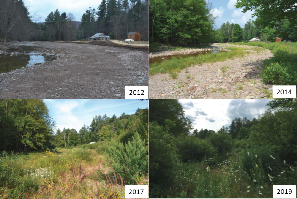
An example of the CSBI’s success in the Neversink watershed is shown in Figure 6-9. Willow cuttings were installed during the dormant season to stabilize streambanks, intercept overland flow, and trap sediment. The rapid growth and vegetative reproduction (from root sprouts) of willow fostered the subsequent establishment of other trees species and herbaceous plants, largely from windblown seed. As new vegetation consolidated its hold on the site (compare 2017 and 2019 in Figure 6-9) this diverse community of native plants excluded problematic invasive plants (e.g., Japanese knotweed). In a relatively short period of time (three to five growing seasons) the steady increase in leaf fall helped to reestablish the litter layer, seed bank, and organic horizon of the riparian area soil—augmenting its effectiveness as a pollutant sink. If a site is not amenable to willow (e.g., because of steep streambanks and a deeper saturated zone), there are many other tree species that can be matched to soil and site conditions.
NYC DEP convenes an annual meeting each winter with all CSBI staff from the soil and water conservation districts to review work to-date, discuss successes and persistent problems, disseminate new scientific and operational insights, and plan for the forthcoming year. This program-wide staff meeting would be an excellent venue for the presentation and discussion of forest regeneration monitoring data, followed by information sharing and preliminary planning for remedial work on earlier sites that are not well established. The approach and site-specific adaptation of the four soil and water conservation districts varies across the WOH watershed (e.g., use of herbicides to control invasive plants, watering, weed mats, tree tubes, deer fencing, high densities of willow cuttings, and bioengineering techniques). Such site-specific approaches avoid the “one-size-fits-all” constraint and have the beneficial multiplier effect of expanding the collective experience of the entire CSBI staff. Designation or development of demonstration sites in each SCWD—with before and after and above and below water quality sampling and data analysis—could help to advance the goals and build upon the early success of the CSBI. A time series of photographs from an established vantage point (e.g., Figure 6-9) is a very effective way to engage landowners, community members, environmental organizations (e.g., Trout Unlimited, Audubon Society, The Nature Conservancy, and many others), volunteers, and government officials.
Landowner and local government interest in the CSBI would likely be enhanced if the long-standing USDA Conservation Reserve Enhancement Program (CREP) model of modest annual payments for riparian forest buffer establishment and maintenance were adopted as a recruitment, management, and retention tool. The Watershed Agricultural Council and Watershed Agricultural Program, the Chesapeake Bay Program, and many others have applied the CREP model with sustained success.
Outreach and Education
Ongoing education, training, and outreach have been crucial to all parts of the SMP. The NYC DEP promotes a stream stewardship ethic for an informed constituency, and provides (or assists in providing) educational activities for a variety of audiences, both layperson and technical, as well as technical assistance to land-
___________________
6 See https://www.fia.fs.fed.us/ (USDA Forest Service Forest Inventory and Analysis Program).
owners and municipalities. Program advisory committees comprised of local leaders and agency advisors meet quarterly to exchange information and guide program priorities. During development, adoption, and implementation of stream management plans, public participation is possible through meetings, focus group discussions, workshops, and activities such as stream clean-ups and streamside plantings. Annual action plans with basin priorities and schedules are available to the public.7 Numerous conferences and other events are held at various intervals, such as the recently established biennial Catskill Environmental Research and Monitoring Conference that provides researchers and managers who work in the Catskills opportunities to share findings of their work, develop collaborations for interdisciplinary projects. Demonstration projects have been used for training and public education. Recently, NYC DEP submitted a training plan with the State University of New York at Ulster for municipal officials to raise the level of training for watershed stakeholders (NYC DEP, 2016).
PROGRAM EFFECTIVENESS
The SMP uses a variety of metrics to report the success of its program. One metric is the number of stream management projects completed since program inception. The distribution of project types completed over time, with length of stream affected by each type, is shown in Figure 6-10. From this chart, it can be seen that the number of projects completed per year generally has decreased since 2013, but also that 2013 had an unusually large number of projects, particularly streambank stabilization projects. The need for bank stabilization projects was driven by the occurrence of large floods, particularly Tropical Storms Irene and Lee in 2011, and the need to repair some earlier remediation sites. It also can be seen in this chart that the number of riparian
___________________
plantings generally has decreased since the period from 2010 to 2013, whereas the number of full-channel restoration projects peaked in 2013 and 2014.
Table 6-2 lists the number and cost of each stream management project type, as well as the length of stream impacted by each type. Some differences in terms of accounting are revealed. For example, although 61 percent of all projects are riparian buffers, they account for only 44 percent of the total length of stream affected. Furthermore, their total costs—and cost per unit length of stream—are significantly less than full-channel restoration and bank stabilization projects.
The total length of streams affected by some form of stream project is 43.8 miles, only about 1.2 percent of the total length of streams (3,693 miles) in the WOH region. Riparian buffers constitute the largest percentage (45) of the restored steam length. Although the percentage of total stream length restored by bank stabilization, full-channel restoration, or floodplain restoration is small, only 0.6 percent, the SMP has targeted sites that emerged as chronic problem areas during the processes of assessing and mapping stream corridors, generating Stream Feature Inventories, and prioritizing reaches for treatment in stream management plans. These plans have identified 87.3 miles of eroding banks from 443.2 miles of stream banks mapped in the WOH region, and of these, 11.8 miles are eroding glacial till or lacustrine sediment.
For riparian plantings, the CSBI has completed about 230 projects on 19 miles of WOH streams—a total of ~110 acres of riparian forest buffers. These projects comprise more than 44 percent of the SMP’s portfolio in terms of stream miles, but with a total cost of ~$700,000 which is less than 2 percent of the total cost of the program. A recent GIS analysis in the Catskill system identified approximately 3,800 acres within a 100-foot stream buffer, on 1,695 parcels, as prospective sites for riparian forest buffer establishment. Hence, the CSBI has plenty of room to grow—both literally and figuratively.
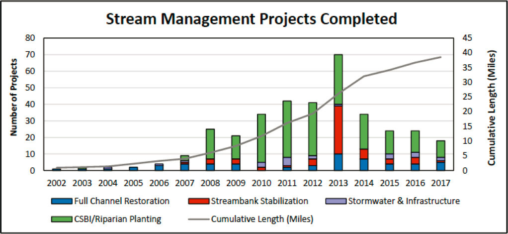
TABLE 6-2 Stream Project Numbers, Costs, Miles of Stream Affected, and Percentages of the Totals
| Project Type | # of Projects | % of Total Projects | Total Cost ($M) |
Length, (miles) |
% of Total Length | Cost per Unit Length ($M/mile) |
|---|---|---|---|---|---|---|
| Full-channel restoration | 60 | 16 | 30.6 | 16.4 | 37 | $1.87 |
| Streambank stabilization | 56 | 15 | 9.8 | 4.5 | 10 | $2.18 |
| Stormwater/infrastructure | 23 | 6 | 4.6 | 0.5 | 1 | $9.20 |
| Post-flood response | 5 | 1 | 0.2 | 2.4 | 5 | $0.08 |
| Floodplain restoration | 2 | 1 | 0.3 | 0.5 | 1 | $0.60 |
| Riparian buffer/CSBI | 230 | 61 | 0.7 | 19.5 | 45 | $0.04 |
| Totals | 376 | 100 | 46.2 | 43.8 | 100 | $1.10 |
SOURCE: Reichheld (2018).
Performance Monitoring
The number of stream projects, total miles of stream treated, or cost of projects presented in Table 6-2 are not measures of whether the treatment achieved specific water quality goals such as sediment load reductions. The true effectiveness of a given project is best determined by measuring specific criteria, such as suspended sediment concentration, from pre- to post-restoration. The SMP is unique among the Watershed Protection Programs because of its greater attention to such performance monitoring of projects. Indeed, the 2007 and 2017 FADs require NYC DEP to evaluate the effectiveness of stream restoration projects in reducing turbidity. Pre- and post-project monitoring are essential to determine if the newly restored channels and floodplains are effective at reducing bed and bank erosion and turbidity in streams. The U.S. Army Corps of Engineers requires monitoring for many of the projects authorized under Nationwide Permit 27 or individual permits, which apply to many of the larger restoration projects. The erosion of channel beds and boundaries are monitored via repeat surveys of stream cross sections, as is done by the SMP for all projects the first and fifth years after restoration. Additional post-restoration monitoring includes repeat photography and repeat stream classification (Rosgen Level II) after the first, second, third, and fifth years.
In addition to monitoring specific restoration projects, suspended sediment and turbidity are monitored at USGS stream gages both upstream and downstream of some installed projects. The NYC DEP has partnered with the USGS to acquire data from many sites throughout the WOH region, and with time has intensified those efforts to better evaluate stream project effectiveness (see the examples in Box 6-2). These efforts are perhaps the single best example of performance monitoring for the NYC DEP Watershed Protection Program. Furthermore, at some sites they indicate substantial reductions in turbidity levels and daily-suspended sediment loads after the completion of the sediment and turbidity reduction stream restoration projects. It is NYC DEP’s intent to use this information to inform and guide future practice at other sites where monitoring might not occur.
The SMP’s emphasis on a scientific approach to studying, characterizing, and monitoring streams, and the longevity of stream studies in the six Catskill watersheds, has resulted in unique benefits. These benefits include an improved understanding of stream processes and of the ways in which streams respond to perturbations, including those changes associated with restoration activities. For example, as a result of prior monitoring, the NYC DEP honed in on the Ashokan basin, particularly the Esopus Creek sub-basin, as a disproportionate source of turbidity to the Ashokan Reservoir during high streamflow (Alcott et al., 2013; Mukundan et al., 2013). Continued investigations of sediment and turbidity identified Stony Clove Creek tributary as the
largest contributor of suspended sediment and turbidity to Esopus Creek, and Beaver Kill as the second largest contributor (McHale and Siemion, 2014; Siemion et al., 2016). As a result of findings from these and other studies, the NYC DEP has directed increasing resources to sediment and turbidity reduction projects in certain parts of the Esopus Creek watershed. In particular, multiyear to decadal-scale monitoring has been established in order to determine the effectiveness of stream projects designed to reduce incoming turbidity (see Box 6-2). This level of effort is laudatory and should be regarded as a national role model for integrating science with both restoration practice and performance-based evaluation of restoration designs.
PROGRAM EVALUATION
Choosing and Developing the Best Approach to Stream Restoration
During the Committee’s meetings with NYC DEP staff, it was explained that the NCD approach has been used for many WOH projects, partly because it is useful to communicate using the simplified classification language associated with NCD. Staff also acknowledged that in practice it is challenging to apply NCD in a region with slopes as steep as those in parts of the Catskills, where bedrock streams are punctuated by waterfalls, lined with patches of glacial till and clay, and reference channel conditions are challenging to locate. Furthermore, many projects are adjacent to infrastructure and require application of hydraulic engineering principles. Many projects entail substantial amounts of geotechnical design to mitigate failure from steep hillslopes with unconsolidated sediments overlying bedrock adjacent to streams. In cases where hydraulic and geotechnical engineering tools are needed, the NCD does not provide the necessary design parameters for a stable reconstructed (rehabilitated) channel, nor is it valid near bridges and other infrastructure where backwater hydraulics occur upstream, and downstream where there is commonly a transformation from subcritical flow to supercritical flow.
The NCD approach also focuses on identification of bankfull flow, which equates to about 1.5- to 2-year return frequency. Yet in the Catskills, major floods from events such as Irene, Lee, and Sandy represent flows in which the channel must deliver 100-year return frequency discharges. In these locations the NCD approach is likely not applicable for channel design to meet flood protection goals. These concerns with the NCD approach will be exacerbated when considering climate change and a potential for increased frequency of major storm events. That is, an approach based on equilibrium concepts may not be useful where large storms and their associated floods may become the dominant geomorphic control.
NYC DEP staff acknowledge these limitations of a strict NCD approach and are applying a largely NCD approach with modifications as needed and appropriate. For example, on stream corridors where hillslope failure is evident due to geologic conditions in the WOH watersheds, engineering geotechnical applications may be required. When infrastructure is involved, such as bridges, road crossings, and protection of developed property, the program considers hydraulic engineering applications. With time and lessons learned, NYC DEP staff have shifted from using bankfull discharge and associated estimates of bankfull channel geometry to a range of discharges from low to 100-year flows. The Committee commends the use of hydraulic modeling (HEC-RAS) to evaluate existing and proposed conditions for a range of flows and suggests advancing to HEC-RAS 2D, when appropriate, to improve the design of floodplain reconnections and lateral stream habitat and to ensure that proposed structures do not result in unanticipated fast flows. It is appropriate that NYC DEP has developed a hybrid approach, given the primary goals of water quality protection and remediation and the geologic and anthropogenic conditions faced in the Catskill region. Although referring to projects as NCD efforts is effective for communication purposes, what actually is practiced is more complex and appropriate. Making this clearer in various communications and reports would be helpful.
Most Catskill streams are bedrock rather than alluvial, and are heavily influenced by a legacy of glacial processes and deposits from past climatic conditions. As such, they present unusual challenges for stabilizing streams and hillslopes. Many of the “banks” referred to in various SMP documents are described as greater than 20 feet, and sometimes more than 70 feet, in height. These are not stream banks, as SMP staff acknowledge (i.e., they are not alluvial landforms created by modern streams). In the Stony Clove Creek and Beaver Kill watersheds, for example, longitudinal stream sampling by the USGS identified failing hillslopes as the primary source of fine sediment (Siemion et al., 2016). Hence, the SMP is managing both stream instability and hillslope failure in some parts of the Catskills. Hence, the program is faced with the broader challenge of landscape, rather than stream, management along some corridors.
Stream Feature Inventories provide an opportunity for the SMP to adopt new restoration approaches. For example, if it were to become a goal of the program to do ecological enhancement, the inventories could be expanded to quantify mesohabitat features. MesoHABSIM (already used by NYC DEP) and PHABSIM (River
2D) can be effectively used to assist in restoration design (see Booker and Dunbar, 2004; Pasternack et al., 2004; Schwartz, 2016). A review of the functional traits of the aquatic species populations to be enhanced could be useful to better incorporate meso- and microhabitat features into projects (Clifford et al., 2005; Newson and Newson, 2000; Rabeni and Jacobson, 1993; Schwartz, 2016).
Given the conditions unique to the WOH region, it is appropriate for the program staff to pick and choose from various restoration approaches, particularly as they learn from experience with each project and its subsequent monitoring. The same has happened elsewhere in the United States, as companies and agencies doing stream restoration adapt to the conditions in their regions and learn from past projects.
Using Remote Sensing for Stream Corridor Assessment and Monitoring
Many of the tasks required for stream assessment could be done with drones and airborne LIDAR rather than boots-on-the-ground fieldwork. The latter is time-consuming and difficult, constrained by site access, weather, safety issues, and other challenges. Throughout the United States, restoration scientists and practitioners increasingly are using both airborne LIDAR and drone photogrammetry to map stream corridors. The technology has become more accessible and affordable, and the resolution of topographic data is ever increasing. The use of structure-from-motion to generate 3-D data is particularly useful in characterizing and monitoring bank erosion. Airborne LIDAR is highly valuable for identifying hillslope failures. Doing repeat surveys with these technologies makes it possible to compare surveys over a period of years to document change (e.g., bank erosion).
NYC DEP staff indicate that they are now using drone technology to document pre-project site conditions and prepare high-resolution topography from photogrammetry to evaluate site stability and channel morphology and to quantify erosion and deposition over time (K. Kane, NYC DEP, personal communication, 2020). They also are using drone and LIDAR technologies for project planning and design and intend to use them for as-built, post-construction, and post-flood monitoring. They have also been able to locate zones of incision and channel-linked mass wasting from use of DEM of Difference analysis from LIDAR data acquired in 2009 and 2014 for the Ashokan and Neversink watersheds. Further, they acquired additional LIDAR data in 2019 for the remainder of the WOH watershed area, and once a 1-meter DEM is available from these data, they will use it for further DEM of Difference analysis. The Committee commends these efforts and recommends continued ramping up of the use of these technologies.
Better Data Analysis
NYC DEP has done excellent work identifying high-priority locations for treatment, implementing aggressive and scientifically-based treatment actions, and collecting relevant data both upstream and downstream and before and after the treatments. These data should allow them to do meaningful analyses of the effectiveness of key parts of the SMP.
The analysis of effectiveness is not simple, and it is time-consuming to acquire the adequate long-term monitoring data with sufficient statistical power. In addition, significant statistical expertise is required to properly evaluate such data. Analysis of covariance is an example of the type of statistical methods that NYC DEP should consider in their efforts. The goal of their statistical analysis should be to evaluate the extent and nature of the shift in the relationship between turbidity (or sediment concentration) and discharge when comparing the years just prior to the STRP implementation and the years just after it. This analysis would not be a straightforward implementation of statistical methods, such as analysis of covariance, because of the high degree of seasonality and serial correlation that likely exists in these data sets and also because of the potential that the data are influenced by hysteresis. Hysteresis in this case means that for any given discharge the turbidity on the rising limb of a hydrograph is likely quite different from the turbidity at the same discharge on the falling limb.
Truly conclusive answers are probably not achievable until there have been several years of data since the STRPs were implemented and also probably depend on the timing of future large storm events. However, incremental efforts to evaluate the data need to be pursued, and these results should be published in peer-reviewed journals. The NYC DEP and USGS have laid an excellent foundation for such evaluations to take place and it is now time to define and apply such analyses. Making the data available so that other scientists and engineers in universities, government agencies, and the private sector can conduct their own analyses is critical. Through such a data analysis process, the true effectiveness of the STRPs in the Upper Esopus Creek watershed can be evaluated.
Modeling in the Stream Management Program
Described in greater detail in Chapter 12, the NYC DEP’s watershed model, the Soil and Water Assessment Tool (SWAT), simulates hydrology from climate, topography, soils, and land cover inputs and water quality from pollutant transport functions. The SMP could potentially use the output from SWAT to estimate a range of flows at any location in the watershed in terms of return frequencies: 2-year return, 10-year return, 100-year return, etc. Using these flow estimates from SWAT with an open-channel hydraulic model (e.g., HEC-RAS), the channel flow capacity based on existing and proposed morphological dimensions can be assessed. Bed and bank stability can be assessed using shear stress estimates obtained from the hydraulic model and comparing these estimates with bed and bank resistance properties. In addition, a hydrology/hydraulic approach could allow for a multistage design, including higher flow stages (100-yr return) to better design infrastructure protections and floodplain reconnection. This approach has already been used by NYC DEP for projects near critical infrastructure, for example, the Stony Clove Creek project designed by consultants Milone and MacBroom, Inc. The key benefit of a hydrologic/hydraulic approach for restoration design over the NCD regional curve methods is that models can be used to estimate changing flow regimes per future conditions from land use conversions (rural to urban) and/or climate change. These hydrologic changes are not accounted for with the use of regional curves and the NCD approach to stream restoration.
The advantages of a 2-D hydrodynamic model over the 1-D HEC-RAS model currently used are that lateral velocity vectors can be estimated and used for a bank stability analysis, and this analysis can be completed at multiple stages. Other advantages of a 2-D hydrodynamic model include obtaining estimates of floodplain inundation and channel hydraulics for mesohabitat design. The use of a 2-D model would advance the SMP’s restoration design methodology while providing a check on the use of the NCD reference reach approach.
Improving the Flood Hazard Mitigation Program
The Flood Hazard Mitigation Program fills an important niche, addressing stream management at the interface of population centers in towns and villages. The program is strongly community driven, with local flood advisory committees working directly with consultants to identify and evaluate potential projects that can reduce flood risks. Yet there remain several challenges in implementation of the program. According to NYC DEP, the program rules, guidelines, and priorities for funding are still evolving (Reichheld, 2018). A concern of NYC DEP is ensuring that City funding supplements rather than replaces state and federal mitigation funding, yet it is difficult to discern how to track funds and ensure that they are additional. Further, many projects are predicated on community cost sharing. The implication of these requirements is that though the LFAs may identify a set of preferred projects, how such projects are prioritized for funding and whether the projects will be funded remains uncertain. In practice, projects that are implemented may be selected based on funding streams rather than flood mitigation or water quality criteria, and priority projects may not be implemented due to a lack of funding. Clearly funds are not unlimited and not all projects will be implemented. Clearer guidelines that specify project eligibility and prioritization, as well as closer coordination with local communities in identifying and seeking funding from non-City sources, will help to ensure that the Flood Hazard Mitigation Program best achieves its intended objectives.
Need for Multiple Program Coordination
The SMP would benefit from more closely coordinating activities and sharing of information with other watershed protection programs (beyond the CSBI and other programs already mentioned in this chapter). For example, the Watershed Agricultural Program is doing stream restoration projects including the construction of riparian buffers, but usually assisted by the NRCS and not the SMP staff. The SMP, for example, could coordinate with the agricultural program to advance stream restoration design strategies specifically for nutrient-laden runoff. The Land Acquisition Program should be notified by the SMP of higher-priority areas to target for purchase in order to commence restoration projects for water quality improvement, hydrologic connectivity, riparian corridor/stream habitat preservation, and ecological enhancement. The Land Acquisition Program could also benefit from SMP information about existing high-quality forest riparian corridors that should be preserved as well as forested headwater areas, which regulate watershed hydrology, both in terms of flood control and baseflow supply, and provide the bedload supply for downstream mesohabitat maintenance. More collaboration between the Catskill Streams Buffer Initiative, NYC DEP forestry staff, and the Watershed Forestry Program (WFP, see Chapter 10) could benefit all three programs, e.g., by sharing knowledge and field expertise, by CSBI gaining referrals of private landowners from the WFP, and by mobilizing more people for the busy tree planting season. Finally, though not as critical in the WOH watershed with its low population density and urban areas consisting of small towns and villages, stormwater management practices could be integrated with stream restoration (as described by Walsh et al., 2005, for developed urban lands).
Impact of Climate Change on Restoration Design Strategies
The changing climate ensures that historic geomorphic and ecological data alone will not be sufficient when designing stream restoration projects meant to be successful under future conditions (discussed in Chapter 4). Estimates are needed on how the frequency, magnitude, and duration of the dominant (channel-forming) discharge used in restoration design will change in the future. It has long been recognized that alluvial channels adjust their geometry and slope to match their inherited discharge and sediment supply from upstream (Wolman and Miller, 1960; Yu and Wolman, 1987). Some attempt to translate changes in hydrology and sediment yield to changes in hydraulic geometry relationships is needed, for example to update bankfull widths and depths for a future hydrological regime (e.g., Li et al., 2015). The challenge and innovation in current channel designs is how to create channels at present that will be sized appropriately for flows of water and sediment in the future. A two-stage channel has been suggested as one means to design a channel planform that remains stable under changing flow regimes. Utilizing the NCD approach based on bankfull dimensions of today might not represent the channel dimensions needed in a future hydrological regime and flood flow capacity, potentially leading to structural failures in the future.
Community Vitality in the Stream Management Program
Many aspects of the SMP contribute to community vitality, primarily by increasing flood resiliency, though the improvements to stream corridors that benefit ecosystems and aesthetics also contribute to community vitality. Flood events can cause significant loss of property and disruption to community life. Mitigation of flood risks supports community vitality by reducing the extent to which damages occur from flood events as well as by supporting accessibility across the community, which is critical to the provision of emergency services, continuation of economic and cultural activities, and the overall wellbeing of the community. Further, stream projects that improve stream connectivity, reduce turbidity, and otherwise improve the ecosystem support community vitality by supporting livelihoods that rely on a healthy, vibrant environment. Of note is the contribution of the SMP to supporting habitat for fish, as fly-fishing is an important draw of tourists to the region.8
___________________
The SMP is also a significant source of income to residents of the watershed. Over the years, local expertise and capital investment in equipment have developed in the watershed. As new projects are undertaken, the work is commonly contracted out to local individuals and companies with experience in these kinds of restoration projects. This investment is an important contributor to community vitality.
While the SMP, particularly the LFA component, explicitly seeks to select projects that provide strong community vitality benefits, the contributions of the SMP as a whole to community vitality have not been sufficiently examined. The LFA program primarily includes a benefit-cost analysis, with consideration of community preference, and it is unclear whether that analysis examines all aspects of community vitality, or just the direct economics costs of flood damages. Some of the stream management plans explicitly consider the objective of flood mitigation, ecosystem enhancement, and recreation promotion (see e.g., the Upper Esopus Creek Management Plan) whereas others are less explicit about these objectives (see e.g., Woodland Creek Stream Management Plan). The contributions of other components of the SMP to community vitality have not yet been evaluated, nor is it clear whether the selection of projects for implementation could be made in a way that concurrently maximizes water quality and community vitality concerns.
CONCLUSIONS AND RECOMMENDATIONS
The SMP stands out among stream restoration efforts nationwide in that its approach focuses on whole watersheds, and substantial attention is given to scientific investigation, stream corridor mapping, and long-term water quality monitoring. The program has carefully navigated the challenges of selecting appropriate methods of stream restoration for the conditions of WOH watersheds. They have done so by actively and consistently using scientific and engineering research, performance monitoring, and operational experience to understand how Catskill streams function, identify causes of stream degradation and instability, identify and prioritize the best locations for intervention, select the most effective restoration approaches, monitor the response of restored reaches, and adapt their management approach as a result of prior project experience. The following recommendations are intended to enhance the SMP.
Among the entire suite of Watershed Protection Programs, the Stream Management Program is particularly commendable. The program embraces several approaches to restoration design, including NCD and hydraulic engineering models, to reduce the risk of project failure. The protocols for monitoring the geomorphic and hydrologic responses to sediment and turbidity reduction projects are well established and state of the science. The program staff have developed long-term partnerships with many agencies, communities, scientists, and engineers to build an extensive program for stewardship of Catskill Mountain streams and floodplains focused on the overarching goal of protecting and restoring stream system stability and ecosystem integrity.
The Stream Management Program, in collaboration with others, should move into vigorous data analysis even as new data are collected. Scientists with a combination of training and experience in geomorphology, climate science, and statistics such as those at the USGS and university researchers should engage deeply in the data analysis. Conclusive answers about the effectiveness of the SMP will require long-term monitoring of future large storm events as well as innovative and comprehensive analyses of current data.
The New York City Department of Environmental Protection (NYC DEP) should continue to identify areas that are, or might become, sources of fine sediment in tree-covered terrain, and to monitor those sites as well as restored reaches. The SMP invests substantial time and funds in mapping stream corridors for six watersheds and in updating this information each year. Mapping stream corridors, including the areas of mass movement on adjacent hillslopes, could be enhanced and perhaps done more efficiently with greater use of LIDAR data and drone photogrammetry. The NYC DEP should develop a long-term plan for acquiring topographic data using repeat LIDAR and unmanned aerial vehicles and using digital elevation data
more extensively; these data can be used to map stream corridors, detect changes in areas with mass movement and bank erosion at unrestored reaches, and evaluate post-project performance at restored reaches.
To build upon the early success of the Catskill Streams Buffer Initiative (and the USDA Conservation Reserve Enhancement Program), the New York City Department of Environmental Protection (NYC DEP) should identify riparian forest buffer projects that require maintenance (e.g., invasive plant control, deer fencing, enrichment or replacement planting, watering) to realize their full ecological and protective potential. Willow cuttings should be expanded to any suitable sites, and other fast-growing riparian tree species (e.g., cottonwood, silver maple, box elder, river birch) should be considered. NYC DEP should adapt the CREP model of modest payments to participating landowners as an inducement to nonagricultural riparian landowners to join the CSBI. Finally, a demonstration site in each soil and water conservation district could be established, with before and after, above and below water quality monitoring to explore riparian forest buffer effectiveness.
Increased coordination between the Stream Management Program and other Watershed Protection Programs would more effectively prioritize project locations and achieve restoration objectives. The SMP could better coordinate with the Land Acquisition Program, the Watershed Agricultural Program, the Stormwater programs, and the Riparian Buffer Program.
The New York City Department of Environmental Protection (NYC DEP) should more routinely incorporate hydrologic/hydraulic modeling into the stream restoration design process. The use of hydrologic/hydraulic models for stream restoration design is recommended for determining channel dimensions and flow capacity. Using hydrologic/hydraulic modeling will allow NYC DEP to design projects that are better able to function during scenarios of greater future flooding due to climate change. Replacing 1-D hydraulic models with 2-D hydraulic models will enhance the SMP’s design capabilities and allow it to better meet multiple project objectives, such as understanding sediment transport hydraulics and identifying local bed and bank surfaces vulnerable to scour.
REFERENCES
Aadland, L. P. 1993. Stream habitat types: their assemblages and relationship to flow. North American Journal of Fisheries Management 13:790-806.
Alcott, E., Ashton, M. S., & Gentry, B. S. 2013. Natural and Engineered Solutions for Drinking Water Supplies. Boca Raton, FL: Taylor & Francis.
Andrews, E. D., and G. Parker. 1987. Formation of a coarse surface layer as the response to gravel mobility. Pp. 269-300 In: Sediment transport in gravel-bed rivers. C. R. Thorne, J. C. Bathurst, and R. D. Hey (eds.). Chichester, Wiley.
Ashokan Watershed Stream Management Program. 2015. Beaver Kill Stream Management Plan. Shokan, NY: AWSMP. www.ashokanstreams.org.
Baldigo, B. P., A. G. Ernst, D. R. Warren, and S. J. Miller. 2010. Variable responses of fish assemblages, habitat, and stability to natural-channel design restoration in Catskill Mountain streams. Transactions of the American Fisheries Society 139:449–467.
Barton & Loguidice, DPC. 2016. Local Flood Analysis for the East Branch/Main Stem of the Neversink. http://catskillstreams.org/wp-content/uploads/2019/02/Neversink_LFA_Final.pdf.
Beechie, T. J., D. A. Sear, J. D. Olden, G. R. Pess, J. M. Buffington, H. Moir, P. Roni, and M. M. Polluck. 2010. Process-based principles for restoring river ecosystems. BioScience 60(3):209-222.
Booker, D. J., and M. J. Dunbar. 2004. Application of physical habitat simulation (PHABSIM) modelling to modified urban river channels. River Research and Applications 20:167-183.
Castro, J. M., and P. L. Jackson. 2001. Bankfull discharge recurrence intervals and regional hydraulic geometry relationships: Patterns in the Pacific Northwest, USA. Journal of the American Water Resources Association 37(5):1249-1262.
Chin, A., and E. Wohl. 2005. Toward a theory for step pools in stream channels. Progress in Physical Geography 29(3):275-296.
Clifford, N. J., P. J. Soar, O. P. Harmar, A. M. Gurnell, G. E. Petts, and J. C. Emery. 2005. Assessment of hydrodynamic simulation results for eco-hydraulic and eco-hydrological applications: A spatial semivariance approach. Hydrological Processes 19:3631-3648.
Clifford, N. J., O. P. Harmar, G. Harvey, and G. E. Petts. 2006. Physical habitat, ecohydraulics and river design: a review and re-evaluation of some popular concepts and methods. Aquatic Conservation: Marine and Freshwater Ecosystems 16:389-408.
Collins, B. D., D. R. Montgomery, K. L. Fetherston, and T. B. Abbe. 2012. The floodplain large-wood cycle hypothesis: a mechanism for the physical and biotic structuring of temperate forested alluvial valleys in the North Pacific coastal ecoregion. Geomorphology 139:460-470.
Cook, T. L., N. P. Snyder, W.W. Oswald, and K. Paradis. 2020. Timber harvest and flood impacts on sediment yield in a postglacial, mixed-forest watershed, Maine, USA. Anthropocene 29:100232.
Copeland, R. R., D. N. McComas, C. R. Thorne, P. J. Soar, M. M. Jonas, and J. B. Fripp. 2001. Hydraulic Design of Stream Restoration Projects. ERDC/CHL TR-01-28. Washington, DC: U.S. Army Corps of Engineers.
Cornell Cooperative Extension of Ulster County. 2007. Upper Esopus Creek Stream Management Plan Volume I. http://ashokanstreams.org/wp-content/uploads/2012/10/Esopus_volume_I.pdf.
Davis, W. D., and C. J. Callinan. 2013. Diagnostic assessment of Warner Creek, Catskill Mountains, NY – three years of student conducted research: Conclusions and implications. Geological Society of America Northeastern Section 48th Annual Meeting, March 18–20, 2013, Bretton Woods, New Hampshire. http://ashokanstreams.org/wp-content/uploads/2013/07/DDavisNE_GSA.2013.pptx.pdf.
Davis, D., P. L. Knuepfer, N. Miller, and M. Vian. 2009. Fluvial geomorphology of the upper Esopus Creek watershed and implications for stream management. In: New York State Geological Association 81st annual meeting field trip guidebook. New York State Geological Society.
de la Crétaz, A. L., and P. K. Barten. 2007. Land Use Effects on Streamflow and Water Quality in the Northeastern United States. Boca Raton, Florida and London: CRC Press.
Dunne, T., and L. B. Leopold. 1978. Water in Environmental Planning. Macmillan.
Effler, S. W., M. G. Perkins, N. Ohrazda, C. M. Brooks, B. A. Wagner, D. L. Johnson, F. Peng and A. Bennett. 1998. Turbidity and particle signatures imparted by runoff events in Ashokan Reservoir, NY. Lake and Reservoir Management 14(2-3):254-265.
Egholm, D. L., M. F. Knudsen, and M. Sandiford. 2013. Lifespan of mountain ranges scaled by feedbacks between landsliding and erosion by rivers. Nature 498(7455):475-478.
Emmett, W. W., and M. G. Wolman. 2001. Effective discharge and gravel‐bed rivers. Earth Surface Processes and Landforms 26(13):1369-1380.
Ernst, A. G., B. P. Baldigo, C. I. Mulvihill, and M. Vian. 2010. Effects of natural-channel-design restoration on habitat quality in Catskill Mountain streams, New York. Transactions of the American Fisheries Society 139:468–482.
Ernst, A. G., D. R. Warren, and B. P. Baldigo. 2012. Natural‐channel‐design restorations that changed geomorphology have little effect on macroinvertebrate communities in headwater streams. Restoration Ecology 20:532-540.
Grimm, N. B., and S. G. Fisher. 1984. Exchange between interstitial and surface water: Implications for stream metabolism and nutrient cycling. Hydrobiologia 111(3):219-228.
Hey, R. D. 2006. Fluvial geomorphological methodology for natural stable channel design. Journal of the American Water Resources Association 42(2):357-374.
Irving, W. 1851. The Catskill Mountains. The Literary World.
Johnson, P. A., R. D. Hey, E. R. Brown, and D. L. Rosgen. 2002. Stream restoration in the vicinity of bridges. Journal of the American Water Resources Association 38(1):55-67.
Juracek, K. E., and F. A. Fitzpatrick. 2003. Limitations and implications of stream classification 1. Journal of the American Water Resources Association 39(3):659-670.
Kochel, R. C., D. F. Ritter, and J. Miller. 1987. Role of tree dams in the construction of pseudo-terraces and variable geomorphic response to floods in Little River valley, Virginia. Geology 15(8):718-721.
Kochel, R. C., B. R. Hayes, J. Muhlbauer, Z. Hancock, and D. Rockwell. 2016. Geomorphic response to catastrophic flooding in north-central Pennsylvania from Tropical Storm Lee (September 2011): Intersection of fluvial disequilibrium and the legacy of logging. Geosphere 12(1):305-345.
Kondolf, G. 2006. River restoration and meanders. Ecology and Society 11(2). www.jstor.org/stable/26266029.
Lave, R. 2009. The controversy over natural channel design: substantive explanations and potential avenues for resolution. Journal of the American Water Resources Association 45(6):1519‐1532.
Lave, R. 2012. Fields and streams: Stream restoration, neoliberalism, and the future of environmental science. Athens, GA: University of Georgia Press.
Lave, R. 2016. Stream restoration and the surprisingly social dynamics of science. Wiley Interdisciplinary Reviews: Water 3(1):75-81.
Lawlor, S. M. 2005. Determination of channel-morphology characteristics, bankfull discharge, and various design-peak discharges in Western Montana. U.S. Geological Survey Scientific Investigations Report 2004–5263.
Leopold, L. B., M. G. Wolman, and J. P. Miller. 1964. Fluvial processes in geomorphology. San Francisco, CA: W. H. Freeman and Co.
Leopold, L. B., and D. C. Rosgen. 1991. Movement of bed material clasts in mountain streams. Pp. 18-21 In: Proceedings of the Fifth Federal Interagency Sedimentation Conference. S.-S. Fan and Y.-H. Kuo (eds.). Washington, DC: Federal Energy Regulatory Commission.
Li, R., Q. Chen, D. Tonina, and D. Cai. 2015. Effects of upstream reservoir regulation on the hydrological regime and fish habitats of the Lijiang River, China. Ecological Engineering 76:75-83.
Lisle, T. E., J. M. Nelson, J. Pitlick, M. A. Madej, and B. L. Barkett. 2000. Variability of bed mobility in natural, gravel‐bed channels and adjustments to sediment load at local and reach scales. Water Resources Research 36(12):3743-3755.
Malakoff, D. 2004. The river doctor. Science 305:937‐939.
McHale, M. R., and J. Siemion. 2014. Turbidity and suspended sediment in the upper Esopus Creek watershed, Ulster County, New York. U.S. Geological Survey Scientific Investigations Report 2014–5200. https://pubs.usgs.gov/sir/2014/5200/pdf/sir2014-5200.pdf.
Merill, L., and D. J. Tonjes. 2014. A review of the hyporheic zone, stream restoration, and means to enhance denitrification. Critical Reviews in Environmental Science and Technology 44(21):2337-2379.
Miller, S. J., and D. Davis. 2003. Optimizing Catskill Mountain regional bankfull discharge and hydraulic geometry relationships. Presented at American Water Resources Association 2003 International Congress, June 29-July 2. http://www.catskillstreams.org/pdfs/catskillregionalcurves.pdf.
Mukundan, R., D. Pierson, E. Schneiderman, D. O’Donnell, S. Pradhanang, M. Zion, and A. Matonse. 2013. Factors affecting storm event turbidity in a New York City water supply stream. Catena 107(80-88):16.
Mulvihill, C. I., and B. P. Baldigo. 2012. Optimizing bankfull discharge and hydraulic geometry relations for streams in New York State. Journal of the American Water Resources Association 48(3):449-463.
Nagle, G. N., T. J. Fahey, J. C. Ritchie, and P. B. Woodbury. 2007. Variations in sediment sources and yields in the Finger Lakes and Catskills regions, of New York. Hydrological Processes 21:828-838.
Newson, M. D., and C. L. Newson. 2000. Geomorphology, ecology and river channel habitat: mesoscale approaches to basin-scale challenges. Progress in Physical Geography 24:195-217.
Niezgoda, S. L., and P. A. Johnson. 2006. Modeling the long term impacts of using rigid structures in stream channel restoration. Journal of the American Water Resources Association 42:6.
NRC (National Research Council). 2002. Riparian Areas: Functions and Strategies for Management. Washington, DC: The National Academies Press.
NYC DEP (New York City Department of Environmental Protection). 2008. Evaluation of Turbidity Reduction Potential through Watershed Management in the Ashokan Basin.
NYC DEP. 2014. NYC Watershed Stream Management Program Local Flood Analysis (LFA) Program Rules, Final Version. July 23.
NYC DEP. 2016. Watershed Protection Program Summary and Assessment. March.
NYC DEP. 2017. Upper Esopus Creek Watershed Turbidity/Suspended Sediment Monitoring Study: Project Design Report. January.
NYC DEP. 2018. Filtration Avoidance Annual Report for the Period January 1 through December 31, 2018. https://www1.nyc.gov/assets/dep/downloads/pdf/about/filtration-avoidance-determination/fad-11.0-annual-report-2018.pdf.
NYC DEP. 2019a. Current Summaries of Watershed Protection Programs.
NYC DEP. 2019b. Stream Management Program Upper Esopus Creek Watershed Turbidity/Suspended-Sediment Monitoring Study: Biennial Status Report, March.
NYS DOH and EPA (New York State Department of Health and U.S. Environmental Protection Agency). 2017. NYC Filtration Avoidance Determination. Revised 2007 FAD. https://www.health.ny.gov/environmental/water/drinking/nycfad/docs/fad_final_december_2017.pdf.
Pasternack, G. B., C. L. Wang, and J. E. Merz. 2004. Application of a 2-D hydrodynamic model to design of reach‐scale spawning gravel replenishment on the Mokelumne River, California. River Research and Applications 20(2):205-225.
Pasternack, G. B. 2013. Geomorphologist’s guide to participating in river rehabilitation. Pp. 843-860 In: Treatise on Geomorphology. J. F. Shroder and E. Wohl (eds.). San Diego: Academic Press.
Peng, F., D. L. Johnson, and S. W. Effler. 2002. Suspensoids in New York City’s drinking water reservoirs: Turbidity apportionment. Journal of the American Water Resources Association 38(5):1453-1465.
Peng, F., D. L. Johnson, and S. W. Effler. 2004. Characterization of inorganic particles in selected reservoirs and tributaries of the New York City water supply. Journal of the American Water Resources Association 40(3):663-676.
Rabeni, C. F., and R. B. Jacobson. 1993. The importance of fluvial hydraulics to fish-habitat restoration in low-gradient alluvial streams. Freshwater Biology 29:211-220.
Reichheld, B. 2018. Stream Management Program. Presentation at Meeting 2 to the NASEM Committee to Review the NYC DEP Watershed Protection Program. Rhinebeck, NY. October 24-26.
Roni, P., T. J. Beechie, R. E. Bilby, F. E. Leonetti, M. M. Pollock, and G. R. Pess. 2002. A review of stream restoration techniques and a hierarchical strategy for prioritizing restoration in Pacific Northwest watersheds. North American Journal of Fisheries Management 22(1):1-20.
Rosgen, D. L. 1994. A Classification of Natural Rivers. Catena 22:169‐199.
Rosgen, D. L. 1996. Applied River Morphology. Pagosa Springs, CO: Wildland Hydrology.
Rosgen, D. L. 2007. Rosgen geomorphic channel design. Chapter 11 in National Engineering Handbook, Part 654, Stream Restoration Design. Washington, DC: USDA Natural Resources Conservation Service.
Schwartz, J. S. 2016. Use of ecohydraulic-based mesohabitat classification and fish species traits for stream restoration design. Water 8:520. https://doi.org/10.3390/w8110520.
Schwartz, J. J. 2019. Riparian Buffer Protection Programs. Presentation at Meeting 3 to the NASEM Committee to Review the NYC DEP Watershed Protection Program. West Harrison, NY. February 4-6.
Schwartz, J. S., and E. E. Herricks. 2008. Fish use of ecohydraulic-based mesohabitat units in a low-gradient Illinois stream: Implications for stream restoration. Aquatic Conservation: Marine and Freshwater Ecosystems 18(6):852-866.
Schwartz, J. S., K. J. Neff, F. J. Dworak, and R. R. Woockman. 2015. Restoring riffle-pool structure in an incised, straightened urban stream channel using an ecohydraulic modeling approach. Ecological Engineering 78:112-126.
Sear, D. A., S. E. Darby, C. R. Thorne, and A. B. Brookes. 1994. Geomorphological approach to stream stabilization and restoration: Case study of the Mimmshall Brook, Hertfordshire, UK. Regulated Rivers: Research and Management 9:205-223.
Shields, F. D., R. R. Copeland, P. C. Klingeman, M. W. Doyle, and A. Simon. 2003. Design for stream restoration. ASCE Journal of Hydraulic Engineering 129(8):575-584.
Siemion, J., M. R. McHale, and W. D. Davis. 2016. Suspended-sediment and turbidity responses to sediment and turbidity reduction projects in the Beaver Kill, Stony Clove Creek, and Warner Creek watersheds, New York, 2010–14. U.S. Geological Survey Scientific Investigations Report 2016–5157. https://doi.org/10.3133/sir20165157.
Simon, A., M. Doyle, M. Kondolf, F. D. Shields, Jr, B. Rhoads, G. Grant, F. Fitzpatrick, K. Juracek, M. McPhillips, and J. MacBroom. 2005. How well do the Rosgen classification and associated ‘’natural channel design’’ methods integrate and quantify fluvial processes and channel response? Pp. 1-12 In: Impacts of Global Climate Change, Proceedings. R. Walton (ed.). Reston, VA: American Society of Civil Engineers.
Slate, L. O., F. D. Shields, J. S. Schwartz, D. D. Carpenter, and G. Freeman. 2007. Engineering design standards and liability for stream channel restoration. ASCE Journal of Hydraulic Engineering 133:1099-1102.
Small, M. J., and M. D. Doyle. 2012. Historical perspectives on river restoration in the USA. Progress in Physical Geography 36(2):138-153.
USDA NRCS (U.S. Department of Agriculture Natural Resources Conservation Service). 2007. Part 654: Stream Restoration Design. National Engineering Handbook.
Vannote, R. L., G. W. Minshall, K. W. Cummins, J. R. Sedell, and C. E. Cushing. 1980. The river continuum concept. Canadian Journal of Fisheries and Aquatic Sciences 37:130-137.
Walsh, C. J., T. D. Fletcher, and A. R. Ladson. 2005. Stream restoration in urban catchments through redesigning stormwater systems: Looking to the catchment to save the stream. Journal of the North American Benthological Society 24(3):690-705.
Walter, R. C. and D. J. Merritts. 2008. Natural streams and the legacy of water-powered mills. Science 319(5861):299-304.
Wohl, E., and D. J. Merritts. 2007. What is a natural river? Geography Compass 1(4):871-900.
Wohl, E. 2011. Threshold-induced complex behavior of wood in mountain streams. Geology 39(6):587-590.
Wohl, E. 2013. Floodplains and wood. Earth-Science Reviews 123:194-212.
Wohl, E., S. N. Lane, and A. C. Wilcox. 2015. The science and practice of river restoration. Water Resources Research 51(8):5974-5997.
Wohl, E. 2019. Forgotten legacies: Understanding and mitigating historical human alterations of river corridors. Water Resources Research 55(7):5181-5201.
Wolman, M. G., and J. P. Miller. 1960. Magnitude and frequency of forces in geomorphic processes. The Journal of Geology 68(1):54-74.
Wondzell, S. M. 2011. The role of the hyporheic zone across stream networks. Hydrological Processes 25(22):3525-3532.
Yu, B., and M. G. Wolman. 1987. Some dynamic aspects of river geometry. Water Resources Research 23(3):501-509.


