
10
Ecosystem Protection and Management Programs
Protecting terrestrial and aquatic ecosystems is central to maintaining the New York City Department of Environmental Protection’s (NYC DEP’s) filtration avoidance status and supplying high-quality water to its consumers. Indeed, the 2017 Filtration Avoidance Determination (FAD) notes that well-functioning, intact natural ecosystems of the watersheds are critical for protecting, conserving, and enhancing downstream water quality. The NYC DEP has several programs that characterize forest, wetland, and aquatic ecosystems, assess their condition, and take action to ensure their continued functioning. This chapter reviews the three forest conservation programs in the west-of-Hudson (WOH) watershed, followed by the Wetlands Program, the Terrestrial and Aquatic Invasive Species programs, and the Aquatic Ecology Program.
The forests of the Catskills, which cover from 70 to 90 percent of the land in the six WOH reservoir watersheds, are the solar-powered living filter of New York City’s water. Understanding and quantifying the effects of the ~1,000,000-acre Catskills forest on natural organic matter, pH, and nutrient cycling are central to streamflow and water quality monitoring, modeling, and management. Additionally, timber harvesting on private forest land contributes to community vitality (particularly the economic vitality) of the region and other communities in western New York. Hence, preventing short-term adverse impacts on water quality (e.g., sediment and nutrient transport to tributary streams) and fostering silvicultural methods to increase tree species diversity and forest health are core goals. These goals are especially important as second- and third-growth forests mature (see Chapter 2) and logging activity increases in response to international market demand for fine hardwood lumber and veneer. Paradoxically, the forestry programs are small in staffing and budgetary terms, which is not commensurate with their key role across most of the WOH system.
FORESTS AND FORESTRY
The earliest written record of a community establishing a “protection forest” by name occurred in 1342 in Switzerland (Kittredge, 1948). People in small mountain villages observed the direct link between deforestation, landslides, debris torrents, and snow avalanches and took collective action to protect their communities. Between 1532 and 1777, 322 protection forests were established across Switzerland. During the 18th and 19th centuries in Europe (principally in Switzerland, France, and Germany), shortages of wood, persistent flooding, accelerated soil erosion, and the extirpation of wildlife led to the development and establishment of forest reserves, forestry as a scientific and managerial discipline, and educational institutions to train scientists and practitioners (e.g., National School of Water and Forests, Nancy, France, 1824).
Forest management principles and practices were transplanted from Europe to the United States in response to the exploitation of forests in the 1700s and 1800s. Popularized by Gifford Pinchot, the first chief of the U.S. Forest Service, and President Theodore Roosevelt, forest conservation became a defining (and con-
troversial) national issue and social, political and economic theme during the early 20th century. Nonetheless, using agricultural journals, local archives, and legislative petitions, Judd (1997, 2014) showed that the roots of the forest conservation movement stem from the communitarian ethic and practical outlook of country people long before it became the cause célèbre among urban intellectuals or politicians.
Forests and Forestry in the Catskill and Delaware Systems
This section focuses on the current forest ownership patterns, management prospects, and stewardship needs in the WOH portion of the NYC water supply system. The east-of-Hudson (EOH) system also has substantial areas of forest cover in a densely populated suburban setting. As such, urban and community forestry is the dominant management paradigm. The challenges and opportunities for forest management in the Catskill and Delaware systems include:
- Legacy effects of 19th century forest uses (and abuses) and the novel ecological conditions (i.e., less diverse, even-aged forests) they frequently created;
- Global markets for wood and forest products as the economic driver for operationally viable silvicultural practices and harvesting methods;
- Disparate values, attitudes, sensibilities, goals, and objectives of landowners (both public and private), communities, and stakeholder groups;
- Intergenerational transfer of land; and
- Imperative for conservation and restoration of forests to sequester carbon as a counterweight to the adverse effects of global climate change.
The geography of forest ownership in the Catskill and Delaware systems has been influenced by the topography and the economic history of this mountainous landscape for centuries (see Chapter 2). With the possible exception of the Cannonsville Reservoir watershed, the total area of forest cover exceeds the general threshold of 70 to 80 percent needed to sustain streamflow regimes and protect water quality (Table 10-1) (NRC, 2008). This observation is not to suggest that forests produce pristine water but simply to note that the presence of forests typically equates to the absence of more potent anthropogenic pollutants associated with other land covers and land uses (e.g., salt, metals and hydrocarbons in stormwater emanating from roads and parking lots). That said, the objectives and actions of landowners, land use history, and the topographic features of each parcel add more variables to the site-specific watershed management equation. Forest conservation and stewardship programs strive to maximize the positive outcomes of landowner decisions and actions.
TABLE 10-1 Proportional Areas of Public, Private, and Total Forest Land by Reservoir Watershed
| Reservoir Watershed | Public Forest Land (%) | Private Forest Land (%) | Total Forest Land (%) |
|---|---|---|---|
| Ashokan | 59 | 30 | 89 |
| Schoharie | 28 | 56 | 84 |
| Cannonsville | 16 | 56 | 72 |
| Neversink | 57 | 36 | 93 |
| Pepacton | 27 | 57 | 84 |
| Rondout | 45 | 43 | 88 |
NOTE: The general threshold for undesirable streamflow and water quality changes is 70 to 80 percent forest land (NRC, 2008).
SOURCE: NYC DEP (2016a) (2009 land cover data) and NYC DEP (2017a).
While the total WOH forest cover percentages (~70 to 90 percent) are very favorable, the relative area and proportion of permanently protected public forest land (i.e., the New York State-owned Catskill Forest Preserve and NYC DEP watershed forests) versus private forest land varies substantially. Specifically, the largest reservoirs—Pepacton and Cannonsville—also have watersheds with the largest total area and the highest proportion of private forest land. As such, the prerogatives and decisions of thousands of private landowners have the potential for positive or negative effects on streamflow and water quality even though they are in nominal compliance with NYC Watershed Rules and Regulations. The Watershed Agricultural Council’s (WAC’s) Watershed Forestry Program (WFP) focuses on this crucial component of the landscape, water supply system, and regional economy.
Spatial Patterns of Forest Ownership
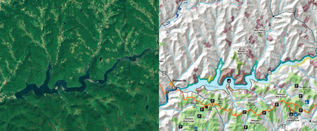
In general terms, state-owned land (the Catskill Forest Preserve) drapes over mountaintops and extends down a portion of the slopes. As such, state land protects many important headwater areas in their entirety but usually does not reach the major streams in the reservoir watersheds. Private forest land is typically located on lower slopes and along stream channels (and roads) and comprises the majority of the land base in the middle reaches—between the upslope public land and the periphery of the NYC reservoirs. Since the dams were sited and designed to impound major streams and flood the largest creek and river valleys, the adjacent uplands serve (also by design) as very large riparian forest buffers. Since the late-1990s, the NYC DEP Land Acquisition Program has added to the width, area, and continuity of reservoir lands and has also purchased large acreages of forest land and farmland in the middle and upper reaches of many streams. The spatial patterns and inherent complexity of forest land ownership in the Catskills, as well as other land uses (agricultural, residential, commercial, and industrial) can be seen in Figure 10-1. While the gray areas on the map on the right do not differentiate between private forest land and agricultural, residential, or commercial land uses, the satellite image (left) shows the distribution of all four land cover types to be primarily in the valleys. The three major forest ownership classes—state, city, and private land—are discussed, in that order, below.
New York State Forest Land
Management of the Catskill Forest Preserve is the responsibility of the New York State Department of Environmental Conservation (NYS DEC), specifically, the Division of Lands and Forests. The NYC water supply system covers part of two NYS DEC regions: Region 3, including Ulster and Sullivan counties in the southern Catskills portion of the NYC water supply system, and Region 4 including Delaware, Greene, and Schoharie counties in the northern Catskills.
The most recent master plan (NYS DEC, 2014) describes the statutory requirements, priorities, and implementation strategies for: (1) wilderness areas, centered on the high peaks of the southern and central Catskills, and (2) wild forest areas, land acquired later around the periphery of the wilderness areas. The “Forever Wild” protection of the Catskill Forest Preserve in the NYS Constitution (1894) strictly limits the scope of NYS DEC’s activities to the management of recreational use. Silviculture, insect and disease control, wildlife habitat enhancement or restoration and other forms of active management are prohibited in wilderness and wild forest areas. Amendment of the New York State Constitution would be required before this management regime could be changed. NYS DEC lands can be generally described as (a) mid- to high-elevation with (b) steep slopes, (c) thin, highly permeable soils, and (d) colder and wetter conditions than lower elevation areas. They are the areas of the landscape with the highest water yields and the longest streamflow travel times to the NYC reservoirs.
Two other unit designations—intensive use areas (e.g., campsites, trailhead parking, and fishing access points) and administrative areas (field offices and infrastructure)—comprise very small areas of the Catskill Forest Preserve lands in the NYC water supply system. The most prominent intensive use area is a four-season state park and ski center, Belleayre Mountain, located in Highmount, New York, near the watershed divide between the Catskill and Delaware systems.
New York City Forest Land
The NYC DEP Natural Resources staff administers the NYC Watershed Forest Management Program (established in 2001), with responsibility for the management and stewardship of City-owned land in coordination with other working groups in the Watershed Protection Program (e.g., the Stream Management Program). The original forestry program (circa 1910) was associated with the construction of the Catskill and Delaware system reservoirs. As was typical in that early era, work focused on the establishment of tree nurseries to produce seedlings for extensive evergreen plantations (red pine, Scots pine, and Norway spruce). At the time, this agroforestry approach was a standard practice by forestry agencies and water utilities, and the default expectation (i.e., foresters plant trees) of the public and political leaders.
Before the Memorandum of Agreement (MOA) was signed in 1997 and the Land Acquisition Program was initiated, NYC DEP owned comparatively small strips of land surrounding the reservoirs (ranging from 1,000 acres around the Schoharie and Rondout Reservoirs to 14,000 acres around the Cannonsville Reservoir). Since 1997, the Land Acquisition Program has added 132,000 acres to the total, including 29,000, 43,500, and 33,800 acres in the Schoharie, Cannonsville, and Pepacton Reservoir watersheds, respectively (NYC DEP, 2016a). These totals include land added to the forests adjacent to reservoirs and many other upland parcels (~50 to 500 acres in size) with abutting private forest, farm, or residential land. NYC DEP is now, in effect, the owner of scores of Catskill Mountain woodlots.
Planning or attempting to manage every acre in this widely distributed set of parcels is unlikely to be practical or to produce meaningful results especially in light of the challenges enumerated in recent watershed forest management studies and reports. They include but are not limited to (1) high deer densities; (2) invasive plants, insects, and diseases; and (3) very limited markets for low-value trees (small diameter, poor form, limited value-added product utility). Since the time horizon for management of NYC DEP forests is “in perpetuity,” not
tied to the service life of a forest products manufacturing facility or investor expectations, an adaptive management (learn-by-doing) philosophy can be applied. Implementing and monitoring a variety of small-scale initiatives would be the most timely and efficient way to foster sustained progress toward watershed forest management goals. In contrast, investing time and money in elaborate inventory, mapping, modeling, and planning—beyond what has already been completed—will simply delay active management (e.g., converting non-native evergreen plantations to mixed-species composition, native forest types using natural regeneration methods).
Mapping, Inventory, and Forest Management Planning—Priorities and Concerns
In 2011, NYC DEP contracted with the U.S. Department of Agriculture (USDA) Forest Service TEAMS Enterprise Unit to complete the first watershed forest management plan (USFS, 2011). This strategic plan includes parcel mapping, forest vegetation inventory (more than 9,000 temporary sample plots), general forest type classification (i.e., broadleaf, mixed, coniferous), timber volume and stocking estimates, and qualitative forest health assessments. It also enumerates and discusses management principles, goals and objectives, and presents a set of recommendations. The plan includes discussions of the management challenges associated with white-tailed deer, invasive insects and diseases (e.g., hemlock woolly adelgid, emerald ash borer, and others), and invasive plants (e.g., common buckthorn, Norway maple, multiflora rose, and others). Notably, the USDA Forest Service plan includes a map set for NYC DEP forests (as of 2011). The last section of the plan (7.1, pp. 273-283) summarizes associated “management needs and opportunities.”
A 2017 summary and progress report (NYC DEP, 2017b) contains additional information and commentary on all of the above and also outlines management strategies. Both documents cite the widely accepted watershed forest management goal of maintaining or enhancing a “vigorous and diverse forest” (Barten et al., 1998; MDC, 1988). However, neither presents an operating plan and schedule, specific examples of silvicultural treatments, best management practice (BMP) effectiveness monitoring, contingency plans, or other customary components of a watershed forest management plan (e.g., Barten et al., 2012; MA DCR, 2018)., Hence, it is difficult to determine what on-the-ground management actions have been implemented by NYC DEP (i.e., area treated, silvicultural prescriptions, tree growth and forest regeneration responses), or what has been planned for the next five to ten years.
The forest hydrology sections of the USDA Forest Service and NYC DEP plans cite basic references for the western United States (e.g., Anderson et al., 1976), but do not access more recent publications pertinent to the northeastern United States (e.g., de la Crétaz and Barten, 2007; Ice and Stednick, 2004; NRC, 2008; World Resources Institute, 2013). Since the primary objective of watershed forest management is to maintain or enhance streamflow regimes and water quality, the underlying science referenced by NYC DEP would benefit from being updated. The uncertainties and operational challenges associated with climate change also underscore the need to access the most current information. For example, loggers and foresters throughout the Catskills and many other parts of the northern United States are struggling to adapt to erratic (warmer and wetter) conditions during most winters. Until recently, frozen soils, a deep, persistent snowpack, and cold temperatures could be relied upon to prevent or minimize damage to the site and degradation of logs awaiting shipment (staining and/or insect damage to the wood) (Berry et al., 2019).
The traditional timber management preoccupation with “overstocked” and “overmature” stands and salvage operations (white ash and eastern hemlock mortality) in both U.S. Forest Service and NYC DEP documents is not consistent with contemporary watershed forest management principles and practices or the ecological forest management paradigm in general (Davis et al., 2001; Franklin et al., 2018). Traditional timber inventory data—tree age, stocking, and species diversity—are key components of any silvicultural plan or prescription. However, they should be augmented with site productivity metrics, growth rate, crown class distribution, and other stand-level indices and attributes in order to evaluate forest regeneration potential, model stand development trajectories, assess risks, and set priorities. This information customarily forms the basis of 20-year, 5-year, and annual operating plans, site-specific contract conditions, and requests for bids
from loggers and procurement foresters. For example, identifying mature even-aged stands on critical sites (with few, if any invasive plants and manageable deer densities [i.e., 5-10 per square mile]), and then using an irregular shelterwood cut to regenerate approximately one-third of the management unit, has proven to be a reliable and effective means of increasing tree species, tree height, and age class diversity in the northeastern United States. Limiting the harvest to one-third (or less) of the management unit avoids or minimizes short-term adverse impacts on streamflow volume and timing and ambient water quality. Repeating the process in 20 to 30 years leads to the establishment of a much more diverse forest (higher stocking, more tree and understory plant species, three age classes, and three or more height and diameter classes) with greater resistance and resilience in relation to acute disturbance (e.g., wind and ice damage, insects and diseases, and novel variations in air temperature and precipitation).
A later document (NYC DEP, 2018a) contains a brief summary with some additional information about the NYC WFP. It reiterates the overall management goal of “promoting forest vigor, resistance, and resiliency to protect and enhance water quality.” A silvicultural treatment recommendation from the USDA Forest Service plan of 40,000 acres between 2012 and 2021 is cited in this report (~4,400 acres/year). This goal was revised in 2017 (29,650 acres treated between 2009 and 2016; ~4,200 acres/year). In both cases, the proportion of the forest on which harvesting operations are proposed would be equivalent to management intensity associated with major forest products companies. Again, since the water supply system will be managed in perpetuity, there is no compelling need to maximize harvesting intensity and area treated. In fact, limiting the area treated in tributary watersheds to 30 percent every five years is the principal way to avoid or minimize short-term negative hydrological impacts until forest regeneration is well established and the water balance returns to a preharvest equilibrium condition (i.e., three to five growing seasons).
Shortly after enumerating these ~4,000-acre/year goals, it is reported that 200 to 600 acres are treated annually through a combination of timber harvesting, salvage (presumably white ash that has been killed by the emerald ash borer), and non-native evergreen plantation regeneration projects (USFS, 2011). This more conservative area threshold and rate of harvesting corresponds with the long-term management activities on other major water supplies (e.g., the Quabbin, Ware, and Wachusett watershed forests of the metropolitan-Boston water supply). No information about silvicultural methods (e.g., thinning, shelterwood, seed tree, variable retention, and patch cuts), harvest volumes, or product types (i.e., fuelwood, sawtimber, etc.) is presented. Hence, it is not possible to evaluate the suitability or potential efficacy of these management activities.
In an associated section on “forest research,” a brief summary of a continuous forest inventory (CFI) system is presented (USFS, 2011); it is not clear whether this system, patterned after the Quabbin Forest CFI system,1 is in the planning stage or early implementation stage. Major advances in forest biometrics, mapping and spatial analysis, statistical methods and software have occurred since the Quabbin Forest CFI plots were established in the late-1950s (with U.S. Geological Survey 7.5-minute quadrangle maps, aerial photographs, compass and chain surveys, and mechanical calculators). This outdated system should not be used as a prototype for NYC DEP forests. The Quabbin CFI system has been maintained (and supplemented with temporary sample plots in proposed harvest units) because of its general strategic value as time-series data with six decades of repeated measurements (Barten et al., 2012). It can, for example, definitively answer frequent questions about the balance between forest growth and timber harvest volumes as well as long-term changes in tree species composition. Apart from these high-level strategic considerations, the value of the CFI database for routine planning and operations is very limited. The sampling density is simply too low (i.e., each 0.2-acre plot on a 0.5-mile grid represents 160 acres, much larger than typical stands or management units). Contemporary forest inventory methods use an integrated system of remote sensing and image analysis, stand delineation, large numbers of temporary sample plots, and variable radius and point sampling field methods (Davis et al. 2001; Franklin et al., 2018). Field data are downloaded directly to a suite of database, image classification, spatial analysis (GIS), and forest growth modeling software packages. After mapping and analyses are completed, the information is applied to the next planning and operations cycle. This approach was applied by the USDA Forest Service TEAMS project and is typical for contemporary forest management operations at this scale (i.e., tens of thousands or hundreds of thousands of acres).
___________________
1https://forestadaptation.org/adapt/demonstration-projects/massachusetts-department-conservation-and-recreation-division-water
The Committee suggests that NYC DEP and the WFP (discussed below) work collaboratively to assess and implement innovative approaches to forest ecosystem management. Examples of these collaborative management actions could include (1) active involvement in the restoration of American chestnut; (2) experimental plantings of suitable evergreen species to fill the niche vacated by eastern hemlock; and (3) working with the USDA Forest Service Northern Institute of Applied Climate Science, other water utilities (e.g., Providence Water), and universities on climate change adaptation strategies and silvicultural methods. Climate change adaptation strategies for forest management include assisted migration and enrichment planting and more extensive use of uneven-aged silvicultural methods.
Private Forest Land
In contrast to a landscape dominated by large National Forests and National Parks in the western United States, about 75 percent of the East is privately owned forest land (USFS, 2009, 2014). Typically, the frequency distribution for the number versus the size of private forest parcels forms a negative exponential curve—meaning that there are thousands of small parcels (10~50 acres), hundreds of intermediate-size parcels (e.g., 50~500 acres), and a very limited number of large parcels (>500 acres) in most counties or regions. Some of the largest parcels are owned by forest products or investment firms; others are owned by wealthy individuals and families. As a consequence, influencing the decisions and actions of thousands of private forest landowners in ways that respect their property rights and financial prerogatives while protecting water quality and other ecosystem services is the central challenge of watershed forest protection and management in the northeastern United States, and more particularly in the Catskill watersheds. This challenge is most evident when the short-term interests of landowners and forest products companies can adversely affect water quality and ecological integrity.
Before World War II, many forest product firms employed their own logging crews who worked primarily on the company’s land. Now, forest products companies would rather buy timber from private landowners than carry very large areas of forest land (and the associated management and property tax costs) on their balance sheet. In the 1960s, mechanization, capital and operating costs, and liability and workers compensation insurance rates increased dramatically. As a result, timber harvesting and trucking were subcontracted to independent firms, and this approach quickly became the industry norm. Logging and trucking firms now bear the high capital costs for equipment (often exceeding $1 million) as well as substantial operations and maintenance costs. These structural features of the working landscape must be considered by watershed forestry programs to balance economic vitality and water quality protection.
As described in Chapter 2, one of the most widespread effects of 19th century “cut and run” logging, tanbark peeling, and forest fires in cutover areas across the northern United States was the conversion of diverse, mixed-species, uneven-aged primary forests to second-growth, even-aged forests with limited species diversity. The simplified structure and limited commercial value of many 21st-century forests is a direct reflection of the earlier mistreatment. Specifically, reliable markets for low-value trees (small diameter, poor form, limited value-added product utility) are needed. Reliable markets enable foresters and loggers to apply a wider range of silvicultural methods (e.g., stand improvement, thinning, small group selection, and patch cuts) to regenerate and restore more diverse forests while meeting basic expectations for profitability. When only the best-quality trees can be sold, the undesirable practice of “high grading” is euphemistically described as “selective cutting.” Unfortunately, removing only the best sawtimber-sized trees, and leaving the low-value trees, typically degrades the ecological, economic and aesthetic values of the forest.
Examples of reliable markets for low-value trees include engineered (laminated) wood manufacturing, pulp and paper mills, pallet manufacturing, panel product mills, and biomass energy. Pallet manufacturing already occurs at mills in the region (e.g., Cannonsville Lumber, Deposit, New York). Other industrial-scale forest product manufacturing would be very challenging—environmentally, politically, and economically—in the Catskills.
The most promising (albeit misunderstood and controversial) form of low-value wood utilization for the Catskills may be small- and intermediate-scale biomass energy generation using wood chip gasification boilers.2
Landowner Preferences, Parcel Size, and Forest Management Prospects
Many, if not most, of the smaller forest parcels (i.e., 10 to 50 acres) are the primary residence of the owner(s) or are a vacation home, and so the prospects for active forest management are often limited. More commonly, timber harvesting is a very low priority for owners who are much more interested in privacy, recreation, and aesthetics than revenue from a one-time timber sale (USDA Forest Service National Woodland Owners Survey3). Some landowners may cut small amounts of firewood, clear trails for walking, skiing and snowshoeing, and cut small openings for vistas and/or wildlife habitat enhancement but are simply not interested in commercial timber sales that would alter the appearance of a substantial part of their property.
Landowners with ~50-500 acres are usually the most amenable to active forest management. They also may have a primary residence or second home on the property but the greater size enables visual buffering of the short-term effects of timber harvesting. Many farms in the Catskills include a substantial area of woodland on the steeper slopes or rocky areas adjacent to their croplands, hayfields, or pastures. These forest landowners and farmers may want or need to harvest trees to generate periodic income and support their way of life. In consequence, they are also the most interested in opportunities for cost-sharing, technical support, and continuing education delivered by entities such as the NYC WFP.
Watershed Forestry Program
The central challenges addressed by the WFP are maintaining water quality while helping private forest landowners to generate sufficient income to counteract development pressure. The WFP foresters interact, whenever possible, with other foresters, loggers, and landowners to enhance the protection of water quality with a combination of outreach, education, technical support, and financial incentives.
Market Demand and Economic Drivers
While development and population growth are often cited as a reliable path to economic growth and vitality, piecemeal conversion of forest land to residential or commercial use may incur greater costs for community services than the additional tax revenue it generates. The old adage “private forests do public good” applies to the many ecosystem services that private forests provide: clean water, clean air, carbon sequestration, terrestrial and aquatic habitat, conservation of biological diversity, and scenic and spiritual values. The periodic harvest of wood from private forest lands also is a renewable natural resource for local and regional firms and a direct contributor to economic vitality. Timber harvesting connects the Catskills to national and international markets. Examples include Cannonsville Lumber,4 Catskill Craftsmen,5 and Baillie Lumber.6 At present, most of the wood harvested in the Catskills is exported from the region. The volume of wood used by cabinetmakers and artisans in the Catskills region is a very small fraction of the logs sold to several large sawmills in western New York.
___________________
2 The most advanced form of biomass energy generation (common in northern Europe and Scandinavian countries) uses a high-pressure boiler to extract methane from wood chips, and then generate steam for combined-cycle heat and electricity generation. Air emissions are mitigated with advanced technologies to remove particulate matter and meet emissions standards for all other regulated pollutants. Bennington College and Middlebury College have replaced their fossil fuel plants with wood chip gasification boilers to substantially reduce the carbon footprint of their district heating and electricity needs and support the local economy. Vermont’s Fuels for Schools program is another successful, well-established example (https://www.biomasscenter.org/images/issues/pdfs/VFFSfactsheet.pdf).
3 See https://www.fia.fs.fed.us/nwos/.
4 See http://cannonsvillelumber.com/web/.
As the forest inventory data presented in the NYC DEP Watershed Forest Management Plan show, the median size and available volume of a number of high-value species (e.g., sugar maple, black cherry, northern red oak) have steadily increased in the second-growth forests that regenerated after 19th century cutting. As this large, even-aged cohort of trees enters the sawtimber size class (>11 inches in diameter) the product possibilities and their relative value increase substantially. For example, 8-inch-diameter yellow birch logs are only suitable for firewood or wood chips—commodities sold by the ton and for which markets are very limited. In contrast, Cannonsville Lumber harvests and processes the yellow birch sawtimber used by Catskill Craftsmen as the raw material for very-high-quality, ready-to-assemble kitchen work centers. This is a noteworthy example of a type of economic development (forest conservation plus value-added manufacturing) that can contribute to long-term watershed protection and stable rural communities. In addition, the proximity to the New York City market, and the potential appeal of a forest product’s watershed pedigree, should favorably influence buying decisions. The same reasons that induce an urban dweller to buy Pure Catskills produce at a Farmer’s Market in New York City also may induce them to reject a bamboo or tropical hardwood kitchen cart from Asia, Africa, or South America—and all its embodied carbon/climate change, ecological and social costs—and “buy local” instead.
Program Structure and Organization
The WFP has been working since 1997 to protect water quality and to support the regional economy. These objectives are met with a comprehensive set of programs and long-term connections with private forest landowners, consulting foresters, loggers, and milling and manufacturing firms. Core funding is provided by the NYC DEP Watershed Protection Program, with additional funding from the USDA Forest Service, totaling ~$500,000 per year. With active and sustained local leadership, and close collaboration with a wide range of people, firms, agencies, and nongovernmental organizations, the WFP has adapted and built upon successful and time-tested approaches in the northeastern United States and across the nation. They include:
- Traditional face-to-face and 21st century web-based extension and education programs,7
- State agency programs for private forest landowners,8
- The American Tree Farm System,9
- BMP implementation and effectiveness monitoring programs,10 and
- Federally funded forest conservation and stewardship programs and social and economic viability programs.11
The adaptive management philosophy and operational methods of the WFP are focused on the protection of water quality from the short-term effects of active forest management (i.e., logging, forest roads and trails, all-terrain-vehicle access, etc.) and through the long-term conservation of forests as a preferred land cover and land use. The WOH WFP staff is based in Walton, New York at the WAC offices. A smaller satellite office for the EOH watershed is located in Yorktown Heights, New York (colocated with the Hilltop Hanover Farm and Environmental Center12). The work of the EOH field office centers on education and training tailored to the suburban setting and needs of local communities.13 The WOH program focuses on the extensive private forest lands of the Delaware system (Table 10-1) and to a more limited extent, on private forests in the Catskill system.
___________________
7 See https://masswoods.org/, https://www.aldoleopold.org/.
8 See https://www.dec.ny.gov/lands/4972.html.
9 See https://www.treefarmsystem.org/.
10 See https://www.mass.gov/service-details/service-forestry; https://www.fs.usda.gov/naspf/index.php?q=topics/water.
11 See https://www.fs.usda.gov/naspf/; https://www.nrcs.usda.gov/wps/portal/nrcs/main/national/programs/easements/forests/.
12 See http://hilltophanoverfarm.org/.
13 See https://www.nycwatershed.org/forestry/implementation/trees-for-tribs/.
A combination of outreach (via the WFP “My Woodlot” website14) and face-to-face interactions at workshops, chainsaw safety training, local fairs and festivals, and association meetings introduces the WFP to landowners, loggers, private consulting foresters, procurement foresters representing major sawmills, educators, students, and other community members. The WFP staff also fosters and encourages peer referrals as a very effective way to expand participation in the program.
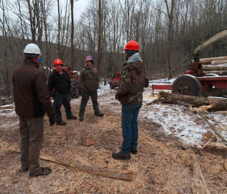
All the stakeholders noted above are important, but loggers are the critical link in short-term and long-term forest conservation and water quality protection (Figure 10-2). New York does not have a forest-cutting practices law and associated regulations, or a notice-of-intent process through which stakeholders who may be affected by a timber harvesting operation (i.e., abutting landowners, government agencies, and downstream communities) are alerted to planned or active operations. The forest landowner, logger, and/or consulting forester are encouraged to apply a system of voluntary BMPs (e.g., NYS DEC, 2018a). But, in the worst case, the existence of a poorly planned and implemented timber harvesting operation may first be discovered by way of a sediment plume from a headwater stream or increased turbidity at a downstream water quality monitoring station.
The WFP relies upon a voluntary approach coupled with modest financial incentives to prevent off-site and downstream impacts. WFP watershed foresters work one-on-one with loggers to avoid or mitigate the water quality impacts associated with logging—specifically, soil disturbance and overland flow that carries sediment and nutrients to streams. Loggers are reimbursed for the time and materials required to install BMPs based on a published fee schedule and field inspections (WAC, 2020). The WFP also provides cost-prohibitive items such as temporary bridges and geotextile underlayment to stabilize trails, roads, and loading areas (landings or log decks). Technical advice and a field-based partnership approach to problem solving by WFP watershed foresters, loggers, consulting foresters and landowners is supported by the NYC DEP at no cost to the logger, landowner, or timber buyer. Farm or forest owners enrolled in either of the WAC conservation easement programs are required to work with the WFP whenever they harvest timber. The WFP’s current approach could
___________________
be augmented with regional field assessment methods for BMP effectiveness developed by the USDA Forest Service (USFS, 2007) in cooperation with state forestry agencies throughout the 20-state northeastern area.
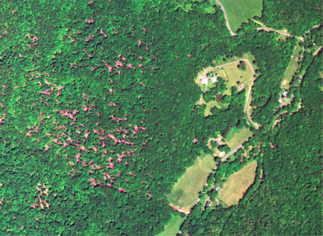
A recent study by the WFP quantified the type and proportion of timber harvesting operations influenced by the program using digital orthophotos, supervised image classification and analysis, and extensive quality assurance/quality control in a GIS (VanBrakle and Pavlesich, 2017). For this study, the WFP staff adapted a method developed by Livengood (2016) with the following project goals:
- Estimate the number of harvests that occur annually;
- Estimate the proportion of harvests that participate in the WFP BMP program;
- Determine the average size (acres) of harvests; and
- Estimate the frequency and size (acres) of harvests occurring within 100 feet of a stream.
The GIS analysis was based on growing-season images from 2013 and 2015 from the National Agricultural Imagery Program with a three-step iterative training process to differentiate timber harvesting and land clearing operations. This analysis was followed by classification of harvesting intensity (i.e., light, heavy, and clearcut). The image classification process was applied to all private land in the WOH portion of the NYC water supply system (Figure 10-3).
The findings for the 2013-2015 study period in the Catskill and Delaware systems were as follows:
- An average of approximately 180 timber harvests (totaling 7,000 acres) annually;
- The WFP BMP program was implemented on 25 percent of those harvests;
- WFP BMP program harvests comprised 2,850 acres of harvested area or 40 percent of the total;
- The BMP program’s coverage is not spatially uniform (i.e., some areas had high participation, whereas others had no BMP projects);
- WFP projects took place in the Cannonsville, Pepacton and Schoharie watersheds;
- There were few, if any, WFP projects in the Neversink, Rondout, and Ashokan Reservoir watersheds;
- The average size of a harvest in the Catskill/Delaware watershed is approximately 40 acres (including the residual trees and canopy openings created by harvesting);
- The total area harvested within 100 feet of streams was about 350 acres/year (5 percent of total harvested area);
- About 60 acres per year of the Catskill/Delaware system is lost to land clearing for development; and
- The rate of permanent forest conversion is about one-tenth of the rate observed in comparable parts of New England (Foster et al., 2017).
This performance assessment will be extended with 2017 imagery and field assessments to refine the characterization of harvesting type and intensity, and the presence, absence, and effectiveness of BMPs. The WFP staff and advisory committee are using this study, in concert with field experience, to devise more effective outreach strategies. For example, they are using tax parcel maps to identify the owners of recently harvested forest land in the Ashokan, Neversink, and Rondout watersheds to disseminate information about the BMP program, schedule of payments, and other inducements to voluntary participation in order to extend the reach of the WFP. WAC also conducted a workload assessment based upon the number of harvesting operations and area or “territory” that can be effectively managed by each watershed forester.
A preliminary estimate of the number of additional full-time employees (FTEs) and additional cost-share funding to reach higher levels of participation was made (e.g., one additional FTE and ~$150,000 in annual BMP funding could double the participation rate) (VanBrakle and Pavlesich, 2017).
WETLANDS PROGRAM
Wetland ecosystems are natural resources of key significance. Conservation of wetland habitat and biodiversity can help to protect and improve water quality. Wetlands provide important ecosystem goods and services such as natural filtration of sediments and biogeochemical removal of nutrients (Bobbink et al., 2006; EPA, 2015; Mitsch and Gosselink, 2015; NRC, 1995). Owing to their hydrological sensitivity and ecological significance, wetland areas are a priority for conservation and restoration during watershed management (Gardner and Finlayson, 2018; Verhoeven et al., 2006). This is reflected in the NYC Watershed Rules and Regulations, which limit a variety of activities in the vicinity of wetlands (see Chapter 3). Wetlands comprise about 1.3 percent of the land use in the WOH watershed, which has changed little in the last two decades (see Table 4-2).
Program Description
The NYC DEP Wetland Program strategy was first implemented in 1996 and updated in 2012, aiming to identify and protect wetland areas given the ecosystem services they provide (NYC DEP, 2012). NYC DEP assesses the extent and status of wetlands in the watershed through mapping and measurement activities, and leverages wetlands protection through regulatory means, land acquisition, and stewardship programs.
Wetland Mapping
Wetland mapping activities within the NYC water supply watersheds provide baseline information needed for regulatory review, land acquisition, forestry, and numerous other programs. Most definitions used for regulation by federal, state, and local agencies recognize wetlands according to their vegetation, soils, and/or hydrology. Classification systems for freshwater wetlands include emergent, scrub-shrub, and forested wetlands; or marshes, wet meadows, vernal pools, ponds, and intermittently inundated floodplains. Wetland areas within the NYC watersheds are identified by evidence of factors including prolonged saturation, predominance of hydrophytic vegetation types, and presence of hydric soil types (NYC DEP, 2009) and are mapped separately from the deep-water wet habitats in the basin such as stream channels, lakes, and reservoirs themselves (NYC DEP, 2018b). A first goal is to characterize the extent, condition, and functions of wetlands. NYC DEP engages in detailed geospatial mapping of wetlands in the watersheds. Possible methods include using synoptic databases such as digital elevation models describing spatial variations in topography15 or locally acquired high-resolution digital elevation terrain data from light detection and ranging [LiDAR] technology (NYC DEP, 2018b). As new datasets provide improvements in the spatial resolution and accuracy of mapped topography, the accuracy in resolving surface depressions and wetland features on the landscape improves. Maps of the topographic wetness index derived from digital elevation data, such as the map shown for the Cannonsville watershed in Figure 5-4, also provide key insights to the distribution of wetland and non-wetland areas across the landscape. The wettest areas of the landscape give rise to the highest values of the topographic index and are typically characterized as having a combination of low slopes, large contributing [flow accumulation] areas, and/or slow soil transmissivity. Topographic index mapping is a key tool for defining areas within the watershed that are permanently or transiently saturated wetland areas, for determining how variable source contributing areas change during wetting and drying of the watersheds, and for prioritizing hydrologically sensitive areas; this technique is well established by scientific studies of the NYC watersheds (Buchanan et al., 2014; Easton et al., 2008; Lyon et al., 2004; Walter et al., 2000).
NYC also uses synoptic databases showing mapped wetland areas, such as the federal (U.S. Fish and Wildlife Service) National Wetland Inventory (NWI) maps.16 The NWI maps available to characterize the extent of wetland areas watershed-wide were most recently updated in 2005 using 1:40,000-scale aerial photography (NYC DEP, 2018b). Field delineations conducted as part of wetland monitoring and forest management programs revealed that the NWI data underestimate the extent of wetlands in the NYC watershed—especially those that are small, transiently saturated, and/or under forest canopy (NYC DEP, 2015, 2018b). Indeed, numerous studies and reviews have highlighted limitations of the NWI, due to photointerpretation and photo quality, scale, and the spatial resolution of synoptic geospatial databases (e.g., Tiner 1999; Handley and Wells, 2009). For example, differences (or lack thereof) in chlorophyll content, soil moisture, and seasonally flooded areas can lead to misclassification of deciduous forests or herbaceous vegetation as wetlands in or near stream channels and can also lead to the misclassification of upland wetlands as forests. In a study of wetlands in the Mid-Atlantic region, Wardrop et al. (2013) found that NWI data underestimate the abundance of inland and upland wetlands by almost 50 percent.
NYC DEP has been working to increase the accuracy and completeness of wetland mapping by using high-resolution topographic data obtained from the LiDAR digital elevation dataset and aerial photographs collected in 2009. A new methodology for applying these higher-resolution datasets to wetland detection and mapping protocols was developed and tested in 15 pilot areas in the NYC watersheds in 2015 (NYC DEP, 2015). Results revealed that the higher resolution LiDAR-derived terrain and hydrographic data and analysis methods greatly increased the completeness and accuracy of wetland mapping in the watersheds and significantly improved the ability to detect the connectivity of wetlands to the surface water system (NYC DEP, 2015). The estimate of total WOH wetland area (15,190 acres) used by NYC DEP and cited in the most recent FAD
___________________
15 3D Elevation Program Products and Services, United States Geological Survey. https://www.usgs.gov/core-science-systems/ngp/3dep/about-3dep-products-services, accessed 6/19/20.
annual report is derived from the NWI augmented with such LiDAR data and detailed field mapping. These techniques have delineated four prevalent freshwater wetland types in the Catskills (palustrine, emergent, persistent, and seasonally flooded/saturated). In contrast, the emergent wetland and woody wetland land cover categories in the National Land Cover Data (NLCD) described in Chapter 4 are based on national-scale analysis of 30-meter resolution Landsat Thematic Mapper imagery. Supervised classification, a decision-tree approach, and post-processing refinements are used to assign each 900 m2 pixel to the best-fit land cover class (of the 15 possible categories listed in Table 4-2) (Yang et al., 2018). The spatial resolution of special-purpose NWI and NYC DEP is nearly three orders of magnitude finer than the source data for NLCD and should be regarded as “ground truth” in comparison with the NLCD, which is designed to detect regional and national changes in land cover/land use (Homer et al., 2020).
Many of the wetland areas in the NYC watersheds are very small (NYC DEP, 2009). To be protected by New York State under the Freshwater Wetlands Act (NYS DEC, 1997), a wetland must be at least 12.4 acres, with an adjacent 100-foot buffer area around the wetland that is also regulated. A wetland area of at least 5 acres is one of the criteria used by NYC DEP to target vacant land parcels for acquisition via the Land Acquisition Program (NYC DEP, 2009). Summary information in the 2019 FAD annual report (NYC DEP, 2020) indicates that there are approximately 15,190 acres of wetlands in the Catskill/Delaware system, covering about 1.45 percent of the watershed; NYC DEP has protected 2,964 acres or 19.5 percent of these wetland areas through the Land Acquisition Program (NYC DEP, 2020). Pre-MOA NYC DEP lands contain an additional 968 acres (6.4 percent) of wetlands, plus an additional 1,275 acres (8.4 percent) of wetlands located on state or other protected lands (NYC DEP, 2020). Taken together, about 35 percent of wetland area in the Catskill/Delaware watershed are protected. The Croton system encompasses approximately 20,025 acres of wetlands, covering about 9 percent of the watershed; NYC DEP has protected 97.1 acres or about 5 percent of these wetland areas through its Land Acquisition Program (NYC DEP, 2020).
Wetland Monitoring
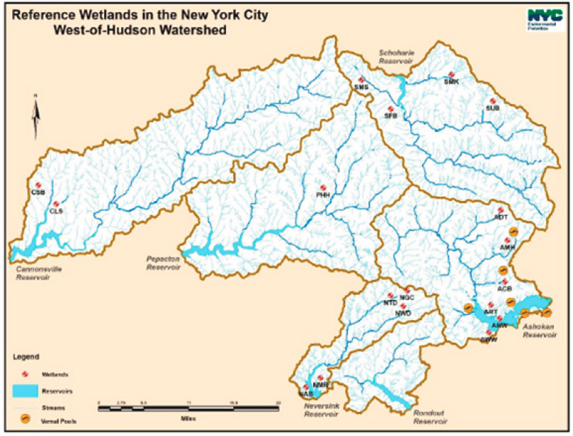
To understand the condition and ecological functions of wetlands in the watersheds, NYC DEP has been characterizing environmental conditions (e.g., soils, vegetation, and hydrology) in a set of reference wetlands within its water supply watersheds (Figure 10-4). Monitoring activities are providing background data on 18 relatively undisturbed permanent or transiently saturated wetlands, plus six vernal pools or temporary ponds (NYC DEP, 2018b). Observational data from the reference wetlands were recently summarized to provide benchmark information about the characteristics of monitored wetlands within hardwood, hemlock hardwood, scrub-shrub, and emergent wetlands in the watershed (NYC DEP, 2014). Based on sites within the reference wetland network, the report details measures of 214 native wetland vegetation species, quantifies nutrient and pH levels from 50 soil samples, and describes the depth and duration of wetland saturation or inundation from approximately 15,000 growing-season measurements recorded at 35 wells. NYC DEP has also used observations from the reference wetlands as ground-truth for considering accuracy of the wetland mapping efforts using synoptic geospatial databases (NYC DEP, 2018b). Further, the observations over time at the reference wetlands have provided understanding of the range of conditions exhibited by natural wetland areas across different vegetation settings (NYC DEP, 2014). Last, the reference wetland monitoring data are useful for assessing the condition of natural wetlands while reviewing wetland permit applications and other land use proposals, as well as for designing and assessing wetland restoration and creation projects (NYC DEP, 2018b).
Wetland Protection and Stewardship
The Wetland Program aims to leverage existing regulatory programs at municipal, state, and federal jurisdictional levels to ensure wetland protection in the watershed (NYC DEP, 2018b). NYC DEP implements the Watershed Rules and Regulations; reviews federal, state, and municipal wetland permit applications; and coordinates with other agencies and municipalities to ensure that permitted activities avoid, minimize, and
appropriately mitigate wetland impacts in the watershed. The NYC DEP uses the geospatial mapping efforts described above to review the proposed activities and evaluate potential water quality impacts (NYC DEP, 2018b). Importantly, wetland areas are protected through acquisition by fee simple or conservation easements as part of the Land Acquisition Program. Wetlands are also protected through NYC DEP stewardship and implementation of BMPs on City-owned lands, where NYC DEP reviews plans for construction projects, land use permits, and other land management activities. Finally, NYC DEP engages partners (e.g., through the Stream Management Program and the Watershed Agricultural Program) and the public (through formal and informal education activities) to foster appreciation of services provided by wetlands and encourage responsible wetland stewardship by private landowners.
Program Effectiveness and Evolution
Results from the mapping efforts have identified permanent and transiently saturated wetland areas throughout the watersheds, providing a perspective on hydrologically and ecologically sensitive areas that is extremely important for guiding watershed management. Results from the wetland mapping LiDAR pilot study indicated that using new high-resolution data along with new geospatial delineation methods increases the accuracy of wetland delineation and increases the acreage of classified wetland areas compared to use of 2005 NWI maps. Scaling up to additional areas in the watershed would refine current wetland maps and provide further insights to connections between upland locations and downstream waters. However, additional precision in the identification of wetland areas is not required for decision making, and the importance of such connectivity has already been well-established in the literature (EPA, 2015; Golden et al., 2019). While the Committee encourages continued use of publicly available data sets at higher resolution as they become
available for efficient wetland mapping updates at regional scales, it does not recommend substantial further investments in the watershed mapping program via expansion of the LiDAR pilot program.
Results from the monitoring efforts have provided substantial knowledge about the variability of wetland types and their ecological status and function. Despite substantial investments in monitoring of a network of reference wetlands spanning a range of environmental conditions, it remains challenging to transfer knowledge from monitored to unmonitored wetland locations given heterogeneity (e.g., in vegetation and soils) and variability (e.g., in climate and weather). Future additional investments in wetland monitoring would yield diminishing returns, and the rationale for major investment by NYC DEP in continued long-term water quality monitoring at existing or new reference sites is not strong.
INVASIVE SPECIES PROGRAMS
Invasive species are non-native organisms that have potential to cause ecological or economic harm once introduced into a new region to which they are not normally adapted. Not all non-native, exotic species are invasive. Without the predators and diseases that might control abundance in their native ranges, populations of some non-native species can spread rapidly in new areas (NYS DEC, 2015). The NYC water supply watersheds are vulnerable to invasions by non-native species of plants, animals, and microorganisms. The characteristics of terrestrial and aquatic invasive species enabling them to compete with native species and alter ecosystems are shown in Table 10-2 (NYC DEP, 2008). Such invasions can have ecological impacts on both terrestrial systems (e.g., biodiversity, wildlife habitat, and biogeochemical cycles) and aquatic systems (e.g., on native fisheries, water quality). Introductions of invasive species have important potential societal impacts on forest and agricultural productivity, outdoor recreation, and tourism, as well as potential costly economic impacts on water utility operations and costs associated with control and remediation.
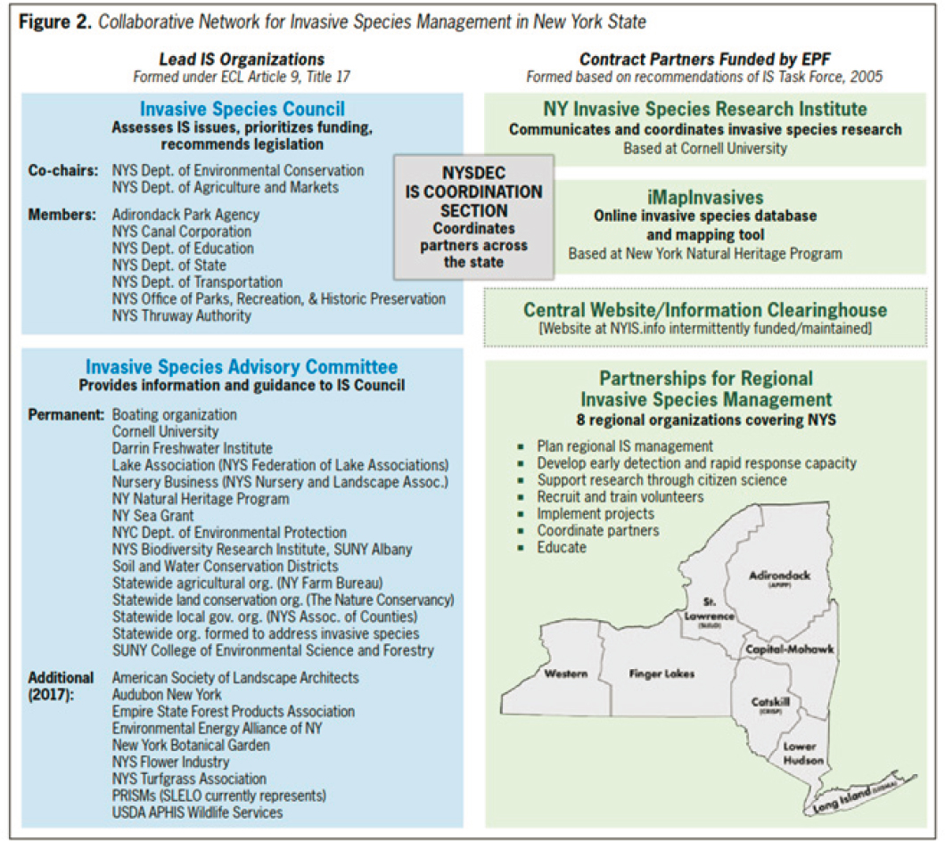
Given the potential negative impacts from terrestrial and aquatic invasive species, NYC DEP recognizes that investments and proactive measures are needed to reduce their introduction and control their spread. NYC DEP has been working to prevent and manage aquatic invasive species since 1993 with the development of the zebra mussel (Dreissena polymorpha) prevention program. An interdepartmental invasive species working group was formed in 2008 to bring the appropriate staff together to develop and make recommendations on an invasive species plan and policies. A white paper (NYC DEP, 2008) was developed to outline the state of knowledge of the impacts of aquatic invasive species to aquatic ecosystems and the City’s water supply, and to make recommendations for preventing and managing the threat of aquatic and terrestrial invasive species, which became the basis for the development of the Invasive Species Program. Since then, NYC DEP promulgated its Invasive Species Management Strategy (NYC DEP, 2016b) and worked with partners to develop a comprehensive invasive species management strategy (NYS DEC, 2018b), striving to protect water quality, ecosystems, and infrastructure. The invasive species management strategy is implemented through an important statewide and regional collaborative network (Figure 10-5), including a wide array of intraagency and external partnerships (NYC DEP, 2016b; NYS DEC, 2018b). NYC DEP holds a statutory seat on the New York State Invasive Species Advisory Committee, which gives advice and guidance to the NYS Invasive Species Council. The council consists of nine state agencies with invasive species prevention and control responsibilities. NYC DEP is also a steering committee member of the Catskill Regional Invasive Species Partnership and the Lower Hudson Partnership for Regional Invasive Species Management. The collaborative network and associated partnerships address threats posed by invasive species across New York State. They plan regional invasive species management activities, implement invasive species prevention programs, conduct surveillance and mapping of invasive species infestations, detect new infestations early and respond rapidly, implement monitoring and restoration projects, and educate stakeholders and citizens on invasive species and their impacts. The collaborations are mutually beneficial, inasmuch as the responses to problematic invasive species often require intensive resources, and the human and financial resources of multiple agencies can contribute to successful outcomes.
TABLE 10-2 Characteristics of Common Invasive Species
| Invasive Characteristic | Examples |
|---|---|
| Lack of predators or pathogens | Asian long-horned beetle, Emerald ash borer |
| Ability of outcompete natives for food and spawning habitat | Round goby, grass carp |
| Ability to alter the environment in its favor by producing growth-inhibiting chemicals, fixing nitrogen, or altering soil microbial or chemical composition to its benefit | Garlic mustard, Japanese barberry, Japanese stiltgrass, spotted knapweed |
| Rapid growth and ability to reach maturityquickly | Japanese stiltgrass, kudzu, mule-a-minute vine |
| Ability to produce large quantities of fruit, seeds, or offspring that are easily spread | Zebra and quagga mussel, Japanese barberry |
| Ability to reproduce/spread vegetatively by suckers, stolons, rhizomes, or rooting at the tips of canes | Japanese knotweed, bramble (Rubus spp. Japanese barberry, multiflora rose |
| Ability to “hopscotch” across gaps in the landscape with propagules (fruits, spores, veligers, etc.) that are dispersed by wind, water or animals | Sudden oak death, zebra and quagga mussel, black swallow-wort, water chestnut, oriental bittersweet |
| Ability to thrive in a broad range of conditions, including disturbed and/or polluted habitats | Phragmites, Norway maple, Tree-of-heaven |
| Ability to inhibit the growth of competitors through dense shade (or high levels of leaf litter) | Norway maple, narrowleaf cattail, Japanese knotweed |
| Ability to inhibit the growth of competitors through a dense root mass | Japanese knotweed, hybrid cattail, Norway maple |
| Ability to maintain photosynthesis beyond the average growing period for native plants | Japanese barberry, Asian shrub honeysuckle |
SOURCE: NYC DEP (2008).
There are five major types of NYC DEP program activities related to invasive species as follows (NYC DEP, 2016b):
- Prevent the introduction of new invasive species into the watershed by mitigating the risk associated with known pathways for introduction. This first line of defense is cost-effective and implemented through laws, regulations, and rules targeting activities that would promote the introduction and spread of invasive species via specific pathways.
- Detect new infestations early and respond to them rapidly. Early detection and rapid response are the methods by which new infestations of an invasive species to an area are identified, contained, and potentially eradicated quickly to minimize the cost of control and impacts to water quality, the environment, human health and the economy. These efforts can be implemented at a variety of scales and require regional cooperation to make them most effective.
- Control and management in order to support specific projects. NYC DEP selects invasive species management projects judiciously with attention to available resources. Aside from rapid responses to early detections, other criteria considered are the impacts to water quality, the threat from the invasive species to the successful outcome of other NYC DEP land management projects, and whether those management actions threaten to increase the impacts of invasive species to the surrounding area. Additionally, appropriate control strategies must be assessed based on their ability to successfully manage the target species.
- Mitigate the impacts of any invasive species that cannot be effectively managed. For example, the emerald ash borer, an invasive insect that was first detected in forest lands of the WOH region in 2010, could not be controlled or eradicated.
- Restore sites to prevent further impacts from invasive species. This activity involves deliberately planting native vegetation species in degraded areas of forests and stream riparian zones.
Terrestrial Invasive Species
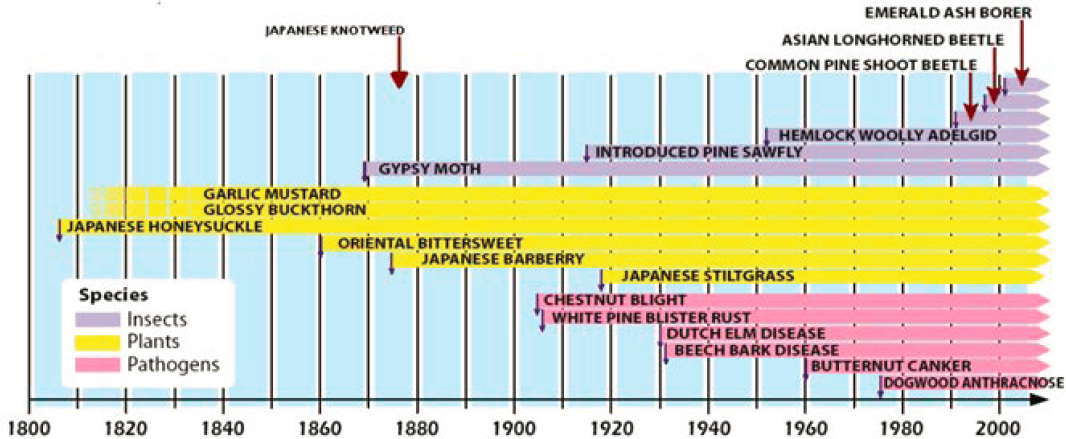
The forested lands in the NYC watersheds are vital to the protection of water quality within the NYC water supply. There are many non-native species affecting the forest, and some cause significant damage due to lack of natural predators and lack of species host resistance (Rustad et al., 2012). Figure 10-6 shows an arrival time line of important terrestrial invasive species that have affected the northeastern forests and the NYC watersheds, including outbreaks of non-native plants, insects, and pathogens (NYC DEP, 2008; Rustad et al., 2012).
The invasive gypsy moth caterpillar (Lymantria dispar) has been a forest pest in the United States since it was introduced from France in the late 1800s. It has since became permanently established in New York and other states in the northeast region, where it feeds on a wide range of tree species but prefers oaks and aspen.17 Gypsy moth populations vary in cycles, and only occasionally do their outbreaks of rapid population increases lead to substantial defoliation and other ecological impacts. During such outbreaks, defoliation caused by the feeding of the moths can reduce the vigor and health of the forest, alter wildlife habitat, lower property values, and reduce the economic value of timber. Past defoliation events in the northeastern United States have led to changes in forest composition as well as water quantity and quality over localized areas and short timeframes (Corbett and Lynch, 1987; Twery, 1991). Population sizes vary based on natural cycles or localized management, as well as emerging fungal pathogens (Hajek and van Nouhuys, 2016).
Three invasive insect species have been the focus of recent intensive forest management efforts in the NYC watersheds due to their major impacts on forest tree species. The Asian long-horned beetle was first introduced into the United States and New York in 1996, likely stemming from pallets or wood packaging imported from Asia. It feeds on many of the forest hardwood species found in the watersheds, but primarily on maples, which are among the most abundant species and are important economically (e.g., for autumn tourism, hardwood products, and maple syrup). The emerald ash borer (Agrilus planipennis) is an invasive beetle also imported from Asia; it was first found in New York in 2009 and it infests and kills ash species. The hemlock woolly adelgid (Adelges tsugae) is an invasive insect that has killed eastern hemlock in most of the EOH watershed for the past few decades. The forestry program has focused on monitoring and controlling the spread of invasive species. For example, NYC DEP has used sentinel and trap trees specifically girdled to stress the trees and attract the emerald ash borer to monitor the spread. Control focuses on eradication when feasible.
___________________
Two invasive insects, the emerald ash borer and the hemlock woolly adelgid,18 have been the focus of recent forest monitoring and control efforts due to their potential impacts on forest tree species in the NYC watersheds, and are pests of continuing concern. The emerald ash borer (Agrilus planipennis), an invasive beetle that can infest and kill ash species, was first found in New York in 2009. Girdled sentinel and trap trees that attract the emerald ash borer have been used to monitor the spread. The borer was discovered in the Ashokan watershed in 2010, after which forestry projects focused on removing infected ash trees. The hemlock woolly adelgid (Adelges tsugae), an invasive insect that attacks hemlocks, has spread in the United States since the 1950s, but reached New York in the 1980s. The woolly adelgid severely impacts hemlock species, where decline and morality of the trees typically occur within four to ten years of infestation, and many hemlocks in the NYC watersheds have been killed in the past few decades. The forestry program has focused on monitoring and controlling the spread of invasive species. Biological, chemical, and integrated pest management methods have been applied to help stop the spread of hemlock woolly adelgid in New York State. For example, a predatory beetle that feeds on the woolly adelgid (Limbu et al., 2018) has been tried as a biological control agent within certain areas of the NYC watersheds.
Invasive trees and shrubs generally reproduce and spread rapidly, crowd out the native flora and their co-dependent wildlife, and form monocultures, thereby reducing biodiversity. Common buckthorn is a large shrub that forms dense thickets reducing diversity of native plant species. Japanese barberry is a thorny deciduous shrub that has also been linked to increased risk for Lyme disease. Japanese knotweed (Fallopia japonica) is an herbaceous plant with bamboo-like stems that can spread rapidly and exclude other vegetation. Garlic mustard is an invasive herb that has spread throughout much of the United States over the past 150 years, becoming one of the worst invaders of the northeastern forest. It is one of a few non-native plants that can dominate the understory in some forests and greatly reduce the diversity of all species. Oriental bittersweet and invasive bush honeysuckle spread rapidly via fruits and seeds eaten and disseminated by birds. In the NYC watersheds, monitoring and surveys have identified invasions of numerous plants, including buckthorn, garlic mustard, bush honeysuckle, Japanese barberry, Japanese knotweed, Japanese stilt grass, multiflora rose, oriental bittersweet, purple loosestrife (Lythrum salicaria), black swallow wart, autumn olive, Norway maple, common reed (Phragmites australis), tree of heaven, and winged burning bush (NYC DEP, 2008).
One goal of the NYC watershed silvicultural management activities is to maintain or enhance the diversity of the forest in terms of tree age and species composition (NYC DEP, 2017b). Meeting these goals can promote forest resiliency against invasive species and other vectors of change and promote regeneration and succession of native species. As part of the systematic forest surveys and natural resource inventories (described earlier in the chapter), data are collected to characterize forest density, tree species, size, condition, forest types, understory composition, and species regeneration (Harman et al., 2014). Damage impacts from invasive species are also used to consider management strategies to understand forest health and to foster adequate forest regeneration. NYC has undertaken several recent horticultural projects on invasive species management, including control of Japanese barberry and other invasive plants in advance of timber harvesting operations, removal of silver vine in EOH basins, experimental biocontrol to reduce impacts of hemlock woolly adelgid and Japanese knotweed in WOH basins, and control of purple loosestrife and common reed at several wetland mitigation sites.
An invasive insect that has been an ongoing concern is the Asian long-horned beetle (Anoplophora glabripennis19), which was first introduced into the New York City area in 1996, but has not been prevalent in the NYC water supply watersheds. The insect feeds on maple and many other abundant hardwood species and can cause their decline and mortality. After several decades of efforts to remove infested trees and eradicate the beetle, the U.S. Department of Agriculture declared New York City free of the Asian long-horned beetle in October 2019.20 Given that there are still populations of the Asian long-horned beetle in other regions of the country, monitoring efforts in the NYC watersheds are still important and ongoing.
___________________
18 Emerald ash borer, https://www.dec.ny.gov/animals/7253.html; and hemlock woolly adelgid, https://www.dec.ny.gov/animals/7250.html
19 Asian long-horned beetle, https://www.dec.ny.gov/animals/7255.html
20https://www.aphis.usda.gov/aphis/newsroom/news/sa_by_date/sa-2019/alb-ny
A key emerging terrestrial insect of concern in the invasive spotted lanternfly, which affects trees and makes them vulnerable to disease. This invasive insect affects many susceptible native forest species that are present in the NYC watersheds such as tree of heaven, maple, birch, cherry, and ash, as well as apple trees and grape vines. The extent of impacts on these species is unknown, because spotted lanternfly has only recently been detected in North America, but it could have negative overall impacts on forest health and could affect the wine (grape), hardwood lumber, and fruit orchard industries. The spotted lanternfly was first observed in Pennsylvania in 2014, and despite massive efforts and investments to control it, has already spread to 14 of the state’s counties. It has also been found in New Jersey, Virginia, and Delaware. Although no infestations have yet been documented in New York, individual adult lanternfly have been documented in nine New York counties and an external quarantine has been issued (Figure 10-7) that restricts the movement of goods coming into New York from nearby states. The threat is probable, and the entire state of New York has been mapped by scientists as an area suitable for establishment of the spotted lanternfly (Wakie et al., 2019).
Aquatic Ecology and Invasive Species Programs
NYC DEP’s Aquatic Ecology Program aims to understand aquatic organisms in the watersheds and reservoirs. Through surveys and monitoring, observations are made as needed to inventory aquatic flora and fauna – including fisheries, aquatic macrophytes, aquatic macroinvertebrates, mollusks, fish, and plankton (NYC DEP, 2019). Biomonitoring data collected within watershed stream networks and reservoirs are useful toward understanding ecological conditions, tracking the introduction of non-native invasive species, and identifying management priorities (NYC DEP, 2016b). The NYC DEP formed an Aquatic Ecology Working Group in 2018 within the agency, bringing together staff from the Watershed Protection Program, as well as the Water Quality, Research Applications Section, and Source Water Operations Directorates. The goal of the working group is to coordinate knowledge and experience, to consider relationships between aquatic biota and water quality, identify data needs, and make recommendations on managing aquatic invasive species. The Committee commends this important, interdisciplinary exchange, which will facilitate adaptive management.
Economic losses associated with aquatic invasive species can be very large, estimated at $120 billion per year in the United States (Pimentel et al., 2005). Introduction and spread of aquatic invasive species are longstanding concerns in waters of New York State (NYS DEC, 2015). Pathways of introduction of aquatic invasive species include commercial shipping vessels, recreational watercraft, aquarium releases, intentional introductions, nursery plantings, waterfowl, and bait (NYS DEC, 2015). Aquatic invasive species can affect water quality by affecting aquatic ecosystems, food chains, and biodiversity. They also affect water supply operations, such as clogging intake pipes and filtration systems. NYS DEC maintains important lists of common invasive species found statewide, including areas inhabited and control strategies recommended to ensure that they are not spread to new areas.21 For early detection of aquatic invasive species in its water supply, NYC DEP conducts ongoing monitoring and assessment of biota in its reservoirs and important tributaries, and conducted formal risk assessments of more than 50 species to develop a priority invasive species list (NYC DEP, 2019) shown in Table 10-3.
The NYC DEP has implemented policies and regulations to try to slow the rate of spread of aquatic invasive species. The risk of recreational boating on NYC reservoirs is mitigated by rules that require all recreational boats to be steam cleaned prior to use on the reservoir. Recreation rules require angler boats to be steam cleaned, no disposal of live bait on City lands and restriction of felt sole waders. Boat and equipment steam cleaning and inspection protocols have been developed for contractors and DEP boats going into the reservoirs. There is also a field equipment decontamination policy for other field equipment used in reservoirs or tributaries. Further, NYC DEP has undertaken important public outreach and education activities toward preventing spread of aquatic invasive species. They developed an Invasive Species Communication Plan in 2013 to identify appropriate internal and external audiences and develop audience-specific messages to effectively communicate the threats of invasive species and the importance of preventing their introduction
___________________
21https://www.dec.ny.gov/animals/265.html, and https://www.dec.ny.gov/animals/50272.html.
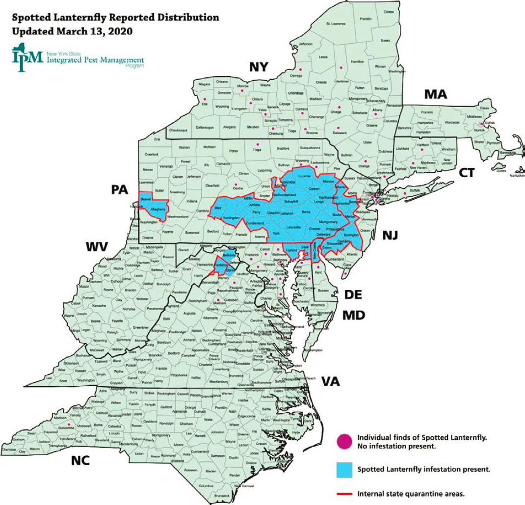
TABLE 10-3 New York City Department of Environmental Priority Aquatic Invasive Species List
| Organism Type | Scientific Name | Common Name |
|---|---|---|
| Aquatic Invertebrate | Corbicula fluminea | Asiatic Clam |
| Aquatic Invertebrate | Cipangopaludina chinensis | Chinese Mystery Snail |
| Aquatic Invertebrate | Bithynia tentaculata | Faucet Snail |
| Aquatic Invertebrate | Cercopagis pengoi | Fish Hook Water Flea |
| Aquatic Invertebrate | Cardylophora caspia | Freshwater Hydroid |
| Aquatic Invertebrate | Potamopyrgus antipodarium | New Zealand Mud Snail |
| Aquatic Invertebrate | Dreissena bugensis | Quagga Mussel |
| Aquatic Invertebrate | Orconectes rusticus | Rusty Crayfish |
| Aquatic Invertebrate | Bythotrephes longimanus | Spiny Water Flea |
| Aquatic Invertebrate | Dreissena polymorpha | Zebra Mussel |
| Aquatic Invertebrate | Eriocheir sinensis | Chinese Mitten Crab |
| Aquatic Plant | Egeria densa | Brazilian Waterweed |
| Aquatic Plant | Didymosphenia Geminata | Didymo |
| Aquatic Plant | Hydrocharis morsus-ranae L. | European Frogbit |
| Aquatic Plant | Trapa natans | Water Chestnut |
| Aquatic Plant | Hydrilla verticillata | Hydrilla |
| Aquatic Plant | Myriophyllum spicatum | Eurasian Watermilfoil |
| Aquatic Plant | Myriophyllum aquaticum | Parrot’s Feather |
| Aquatic Plant | Myriophyllum heterophyllum | Variable-leafed Watermilfoil |
| Aquatic Plant | Fallopia japanica | Japanese Knotweed |
| Aquatic Plant | Lythrum salicaria | Purple Loosestrife |
| Aquatic Plant | Phragmites australis | Common Reed |
| Aquatic Plant | Potamogeton crispus | Curly Leaf Pondweed |
SOURCE: Harman et al. (2014).
and controlling them to mitigate impacts. In coordination with the partnerships for regional invasive species management (see Figure 10-5), NYC DEP works to educate stakeholders and citizens on invasive species, their impacts, and prevention and mitigation measures.
In one important baseline study, NYC DEP contracted with the State University of New York at Oneonta to survey aquatic invasive species in all five terminal reservoirs and in major tributary streams draining into them (Harman et al., 2014). The goal of the survey was to identify the presence or absence of the 23 aquatic invasive invertebrate or plant species that had been deemed as priorities for management by NYC DEP (Table 10-3). Results of these surveys (Table 10-4) showed that the surface waters sampled were free of many of the species of concern at that time, highlighting the opportunity for further prevention of their introduction. However, several aquatic species were present and were deemed to pose threats to the functioning of the reservoirs, including Japanese knotweed, common reed, purple loosestrife, rusty crayfish (Orconectes rusticus), and hydrilla (Hydrilla verticillata). Results also revealed important species that are threats to both the economic and ecological aspects of reservoirs, including water chestnut (Trapa natans) which inhibits boating and blocks sunlight to lower water levels, and zebra mussels, which block intake pipes and filtration systems, causing costly maintenance (Harman et al., 2014).
Nutrient-rich reservoirs in the EOH system support substantial aquatic plant growth. Two aquatic invasive plants of major concern in the NYC water supply reservoirs are hydrilla and water milfoil (Myriophyllum spicatum). Roots of both species nest in bottom sediments and can grow rapidly over long distances, creating dense mats of vegetation that can smother native plants and cause drainage problems. A 2018 monitoring
TABLE 10-4 Aquatic Invasive Species Documented in Surveys of Five NYC Water Supply Reservoirs Sampled by Harman et al. (2014)
| Tributary | AIS Present | Reservoir | AIS Present |
|---|---|---|---|
| Esopus Creek | Fallopia japonica | Ashokan | None |
| Rondout Creek | Fallopia japonica | Rondout | Lythrum salicaria Orconectes rusticus Phragmites australis Potamogeton crispus |
| West Branch Croton River | None | West Branch | Lythrum salicaria Myriophyllum spicatum Orconectes rusticus Phragmites australis |
| East Branch Croton River | Orconectes rusticus | New Croton | Hydrilla verticillata |
| Bear Gutter Creek | None | Kensico | Not sampled |
study of submerged aquatic vegetation (Solitude Lake Management, 2018) surveyed 1,226 sites within the New Croton Reservoir. Eurasian water milfoil occurred at 90 percent and hydrilla at 36 percent of the sites. Other invasive species identified in the reservoir at a few sites included brittle naiad, water chestnut, and curly-leaf pondweed (Potamogeton crispus). While the Eurasian milfoil is long established, the new introduction of hydrilla has more potential for control. Since the identification of hydrilla in the New Croton Reservoir in 2014, NYC DEP has been working to control its spread. Based on results of an expert panel review facilitated by the Water Research Foundation (WRF, 2018), NYC DEP began a pilot treatment program of 20 acres using the fluridone to control hydrilla that will be expanded to a reservoir-wide, multiyear treatment of more than 250 acres (NYC DEP, 2018c, 2019). NYC DEP is continuing to monitor water quality and dispersal of hydrilla, to evaluate the success of the control effort, and to adapt the strategy as necessary (NYC DEP, 2018c, 2020). This effort includes exploring the use of sampling environmental DNA to detect hydrilla, and other priority aquatic invasive species in the WOH reservoirs.
NYC has long surveyed mussel populations in all reservoirs, with the view that early detection could reduce the chance of a new introduction or their spread. Invasive mussels are filter feeders that direct energy and nutrients away from the surrounding benthos, cause shifts in ecological communities, and can change nutrient status (Strayer, 2014). The costs of maintenance at water intakes and drinking water treatment due to dreissenid mussels (zebra and quagga mussels) alone can be huge (Connelly et al., 2007; Pimentel et al., 2005). Biomonitoring identified zebra mussels in the Muscoot River and in Amawalk Reservoir in 2018 and 2019. NYC DEP intensified sampling in the river and all reservoirs and began designs to retrofit the intake structure at the Amawalk Reservoir to allow for treatment with sodium bisulfite (NYC DEP, 2018d, 2019).
Two aquatic invasive fishes of potential emerging concern in the NYC water supply reservoirs and their tributaries are the round goby (Neogobius melanostomus) and the northern snakehead (Channa argus). Both species have been found in other parts of New York prompting surveillance by NYC DEP. The round goby is a small benthic fish native to Eurasia, first introduced in the United States by ballast waters of freighters (Charlebois et al., 2001). Its introduction to the United States has greatly disrupted aquatic ecosystems in the Great Lakes region, where it spread rapidly with substantial impacts on native and non-native aquatic life (Kornis et al., 2012). Round gobies prey heavily on zebra mussels and can consume many juvenile zebra mussels per day (Ray and Corkum, 2001). The interaction of these two invasive species has the potential to displace native species, change food web dynamics, and water quality. The northern snakehead is a large elongated freshwater fish capable of breathing air to migrate short distances over land. Native to Asia, northern snakeheads have been
found in a number of locations in the United States and were probably introduced through aquarium dumping. Northern snakeheads were discovered in Virginia in 2004 where they reproduced and rapidly expanded their territory. This species is now abundant in the Potomac River and its tributaries as well as reservoirs in Maryland and Virginia. The northern snakehead is a top predator, where it preys on native species of fishes as well as other fauna. It has the potential to alter aquatic food chains and disrupt recreational and commercial fishing. When snakeheads are found, concerted efforts to eradicate them should begin as quickly as possible.
Concerns About the Invasive Species Programs and Recommendations for Improvement
Invasive species can have significant effects on water resources. The impacts can be direct (as with many aquatic nuisance species) or indirect (as with terrestrial species that change water tables, streamflow generation dynamics, biogeochemical cycles, or soil erosion). Terrestrial invasive species of concern can typically result in significant changes to the composition and patterns of vegetation across the landscape with associated changes in litterfall, woody debris, soil composition, and microbial communities. This could change the quantity and quality of nutrients (Jenkins et al., 1999) and the resultant composition of natural organic matter issuing from watersheds to streamflow, which in turn could potentially affect disinfection by-product formation potential (Cory et al., 2011). Invasive species might also cause indirect social effects that might influence water quality. For example, fear of invasive pests may prompt more use of pesticides and herbicides, potentially leading to increased runoff of agrochemicals. Further, invasive species can cause economic losses, with potential effects on community vitality. For example, invasive species that result in dieback or mortality of valuable hardwood species may negatively affect the production of associated forest products (e.g., furniture, flooring, maple syrup). Invasive species that cause changes to landscape aesthetics can negatively affect property values (Holmes et al., 2011; Li et al., 2014) and tourism.
An illustrative example is the hemlock woolly adelgid, which has invaded the NYC watersheds and has caused widespread decline of hemlock trees throughout the eastern United States. In many watersheds, hemlocks provide riparian forest cover and bank stability for headwater streams. Studies have evaluated the hydrologic impacts of the infestation and associated hemlock loss. For example, Kim et al. (2017) quantified how the gradual hemlock decline over time altered hydrological regimes in a New England watershed, observing a substantial (~15 percent) increase in catchment water yield, largely due decreases in transpiration and interception as riparian hemlocks declined. In contrast, Brantley et al. (2013, 2015) observed a persistent decline in water yield and seasonal streamflow in response to hemlock infestation in a catchment in the southern Appalachian region, where species that regenerated had higher evapotranspiration rates than the lost hemlocks. Studies have also demonstrated impacts on watershed water quality. For example, Cessna and Nielsen (2012) showed that hemlock dieback due to the woolly adelgid infestation in southern Pennsylvania led to increased inputs of nitrate to streamflow, due largely to changes in nitrogen cycling resulting from the vegetation regeneration. Webster et al. (2012) showed that riparian hemlock loss led to changing inputs of organic matter and litterfall in a Southern Appalachian catchment. The potential responses to the woolly adelgid can vary widely depending on the infestation patterns, catchment conditions, and the composition of vegetation regeneration that follows loss of hemlock species. This invasive species can clearly affect the fluxes of water and nutrients at a watershed scale.
Invasive plants, animals, insects and diseases have been a global problem for centuries. Global trade and deliberate (ecologically naïve) and accidental introduction have transferred organisms from one biome to another around the entire world. In almost every case, invasive species have proven to be very difficult to control—let alone eradicate. In extreme cases (e.g., chestnut blight, Dutch elm disease), they can largely eliminate their host species. Invasive species typically reduce the biological diversity of the site or region.
As noted earlier, invasives can be so successful and problematic because the absence of natural predators, physiological defense mechanisms, and competitive constraints in a new ecosystem allows their population and adverse impacts to grow exponentially. Unfortunately, other circumstances, such a high deer densities and extensive browsing of native plants, coupled with seed dissemination by birds, can exacerbate the spread
and competitive advantage of invasive plants such as Japanese barberry, Asiatic bittersweet, Autumn olive, and multiflora rose (all of which deer will not eat).
Administrative Concerns
The Invasive Species Program aims to identify, prioritize, and address invasive species threats to the water supply and to coordinate monitoring and management. NYC DEP notes that not every invasive species infestation can or should be controlled, and that control projects need to be selected judiciously and within the limits of the available resources. Some factors considered include rapid responses to early detections, ability to successfully manage the invasive outbreak, and potential impacts to water infrastructure and water quality.
The Invasive Species Management Plans (NYC DEP, 2016b, NYS DEC, 2018b) are well articulated and include an expansive range of goals and strategies. The program relies heavily on interagency partnerships, coordinated statewide by the NYS DEC. The communication plan (NYC DEP, 2016b) recognizes the many dimensions of coordination needed to guide communication to targeted internal and external audiences. Given the complex agency and interagency partnerships that are necessary to coordinate responses to invasive species, the role of NYC DEP responsibility, staffing, and funding commitments should be clarified. While NYC DEP spends approximately $1.5 million per year of the overall Watershed Protection Program on ecosystems programs, it is unclear how much NYC DEP funding is invested specifically in invasive species program activities, and it is difficult to assess the coordination of the efforts. As project management efforts at controlling current and future invasive species unfold, the Committee encourages NYC DEP to review and evaluate the effectiveness of these partnerships.
Management Actions
It is a natural reaction for public agencies, environmental groups, and landowners to want to “do something” even when there is little or no likelihood that the intervention or action will succeed. Well-intentioned efforts may inadvertently amplify environmental impacts or lead to unintended consequences. “First, do no harm”—the timeless principle of medical professionals, applies here as well. Herbicides or goats (in fenced areas) have proven to be the most effective means of invasive plant control, but are fraught with potential controversy, especially in a public water supply system. Other more costly and labor-intensive methods of invasive plant control (uprooting, mowing, burning with backpack propane torch, clipping and precise spot application of herbicide to the cut end, prescribed burning, or combinations thereof) can be successful as long as the site is rapidly revegetated and fully occupied with native plants. Preventive approaches (e.g., steam cleaning and disinfecting boats, prohibiting regional movement of potentially infected firewood, winter logging and transportation and rapid milling and kiln-drying of hardwood sawtimber) have proven to be effective means of invasive species mitigation and control.
Management actions that foster species resistance and resilience are bound to be more effective than frontal assaults on invasive species with a low probability of long-term success. For example, enrichment plantings (with deer fencing) of site-adapted tree species in openings created after eastern hemlock succumbs to woolly adelgid would be preferable to below-cost salvage logging (i.e., logging contractors must be paid to cut and remove the trees since they have little or no market value) and the site disturbance it can cause. Patch cuts—centered on white ash trees infected with the emerald ash borer—to foster rapid and diverse regeneration of native trees would be preferable to single-tree salvage cutting that does not produce canopy openings that are large enough to stimulate and sustain seedling and sapling growth. As noted in Chapter 6, aggressive riparian forest buffer establishment and diligent maintenance to prevent the establishment and downstream propagation of Japanese knotweed would be a wise investment. Invasive species mitigation also presents opportunities for adaptive management experiments to enhance biological diversity and prepare for climate change as noted earlier (e.g., planting disease-resistant American chestnut, “assisted migration” of tree species from southern and central hardwood forest types, substitution of non-invasive European evergreen species to fill the niche of eastern hemlock, and others).
There are no easy answers or general formulas for invasive species management. Successful projects and programs are characterized by creative, persistent, site-specific approaches, diligent monitoring, and rapid remediation of new or pervasive problems. Staff resources (e.g., temporary reassignment from other work or programs) and sufficient contingency/urgent response funding could help NYC DEP to mount a rapid and effective response.
Climate Change
An emerging concern is the role that climate change will play on forest composition and health. Chapter 4 discusses the potential effects of climate change on the water balance (e.g., precipitation, temperature, evapotranspiration, and runoff) of the watersheds, though further consideration is needed about the impacts of a changing climate on terrestrial and aquatic species shifts and forest resiliency. The projected regional net increases in air temperature and precipitation, along with the projected shifts in their seasonal distributions (e.g., increase in winter precipitation) are expected to change forest hydrology, biology, and vegetation (Rustad et al., 2012) in the northeastern United States, including the NYC water supply watersheds.
Potential consequences of regional climate change on the water cycle and streamflow are higher temperatures and drier summers, with increased evaporation and transpiration resulting in lower water tables and streamflow volumes. Warmer winters, with more intense storms, less snowpack, less infiltration, and more flooding and channel erosion are predicted (Campbell et al., 2009; Rustad et al., 2012). Potential impacts on forest vegetation include changes in suitable habitat for trees—with some species gaining and some losing habitat—and associated migration of species (Iverson et al., 2019). The increased summer and winter temperatures will increase capacity for invasion of non-native insects, animals, plants, and trees (Rustad et al., 2012). Potential effects on watersheds and water quality are faster decay of leaf litter and acceleration of biogeochemical cycling in soils, resulting in increased carbon losses from soils to air (as carbon dioxide) and to water (as dissolved organic carbon), and increased exports of acids (e.g., hydrogen ions, nitric acid), bases (e.g., calcium), and nitrogen species (e.g., nitrate and ammonium) to streamflow (Campbell et al., 2009; Rustad et al., 2012; Sebestyen et al., 2009). Collectively, climate-induced shifts have the potential to affect many elements of concern to NYC DEP, including changes in streamflow quantity and timing, sediment, organic matter and nutrient transport, and additional invasive species impacts.
CONCLUSIONS AND RECOMMENDATIONS
This review of forests and forestry in the WOH system, as well as the Wetlands Program and the Invasive Species Programs, leads to the following conclusions and recommendations.
The Watershed Forestry Program should grow to increase the proportion of private forest land it influences. Private forest land occupies a key landscape position in the WOH watersheds (between the Catskill Forest Preserve lands at high elevations and the NYC DEP land surrounding the reservoirs). The WFP has active connections to about 40 percent of this private forest land base. Given increasing rates and volumes of timber harvesting, a scale-up of these efforts would be a timely investment in watershed protection and community vitality. Increasing WFP staffing (one or two FTEs) and the operating budget could double the amount of private forest land managed.
The Watershed Forestry Program should adopt and use the USDA Forest Service best management practice effectiveness monitoring protocol. The WFP uses a standards-based approach for BMP implementation and evaluation. The current “presence or absence” approach to water quality BMPs is not sufficient to consistently evaluate effectiveness, prioritize actions, and fully inform adaptive management and progressive improvements. The NYC DEP Forestry staff also should adopt the USDA Forest Service protocol for BMP effectiveness monitoring if it is not already part of their timber sale planning and administration process.
Recent acquisitions and spatial distribution of the New York City Department of Environmental Protection’s forest land holdings suggests a three-tiered approach to management and stewardship in order to maximize program effectiveness. This three-tiered approach would include (1) active management to diversify substantial portions of the reservoir buffer lands (i.e., species composition, age class distribution, tree heights and stand structure, etc.), (2) active management to diversify recently acquired high-productivity parcels in key landscape positions (i.e., protecting important second- and third-order tributaries), and (3) a custodial approach on relatively small, hydrologically nondescript parcels where the return on the investment of management resources is likely to be minimal or undetectable.
A working group of the Watershed Agricultural Council and their local and regional partners could evaluate prospects for small- and intermediate-scale wood chip gasification biomass energy in the Catskills. Reliable local and regional markets for low-value trees are urgently needed to improve standards of silviculture in the Catskills, specifically to provide ecologically sound and financially viable alternatives to selectively removing only the best-quality trees. Biomass-based co-generation of heat and electricity is a promising way to reduce dependence on fossil fuels while developing and sustaining local markets for low-value trees. Study tours of the many successful projects in New England would be a helpful first step.
Further investments in detailed wetland mapping and long-term monitoring are not needed. The locations and ecosystem characteristics of wetlands and other hydrologically sensitive areas within the NYC water supply watersheds are well documented. Many of the wetland areas are small and thus are not protected by state regulations. The Committee reiterates its Chapter 7 recommendation to remove the acreage barriers in the Land Acquisition Program that prevents acquisition of small wetlands (e.g., <5 acres).
The New York City Department of Environmental Protection should clarify the terrestrial and aquatic invasive species programs’ responsibilities within the regional invasive species collaborative network and support these responsibilities adequately. Given the potential environmental, economic, and water quality impacts of invasive species, responding to important outbreaks should be prioritized. The number of different agencies involved in the invasive species programs makes it imperative that the roles and responsibilities of these agencies be well established.
Changes in species composition, land cover, and climate will affect the composition of both native and non-native species throughout the New York City watersheds. Such changes may affect economic vitality (e.g., forest and agricultural products), water availability (including during droughts and floods), and water quality (including changes in loadings of water, sediments, and solutes). Anticipating and responding to these changes in a systematic manner that maintains water quality should include all salient subprograms of the Watershed Protection Program in an integrated effort.
REFERENCES
Anderson, H. W., M. D. Hoover and K. G. Reinhart. 1976. Forests and Water: Effects of Forest Management on Floods, Sedimentation, and Water Supply. USDA Forest Service GTR PSW-018. https://www.fs.fed.us/psw/publications/documents/psw_gtr018/psw_gtr018.pdf.
Barten, P. K., T. Kyker-Snowman, P. J. Lyons, T. Mahlstedt, R. O’Connor, and B. A. Spencer. 1998. Managing a watershed protection forest. Journal of Forestry 96(8):10-15.
Barten, P. K., M. S. Ashton, J. K. Boyce, R. T. Brooks, J. P. Buonaccorsi, J. L. Campbell, S. Jackson, M. J. Kelty, D. I. King, C. H. Sham, J. E. Tobiason, and M. L. Tyrrell. 2012. Review of the Massachusetts DWSP Watershed Forestry Program. Massachusetts Division of Water Supply Protection, Department of Conservation and Recreation. November.
Berry, A., S. Bick, P. Frederick, A. Steele, M. McLarty, And D. Hollinger. 2019. Warmer, wetter logging. The Northern Logger. May 2019. https://northernlogger.com/wp-content/uploads/2019/05/LOGGER_MAY_WARMER_WETTER.pdf.
Brantley, S., C. R. Ford, and J. M. Vose. 2013. Future species composition will affect forest water use after loss of eastern hemlock from southern Appalachian forests. Ecological Applications 23:777-790.
Brantley, S. T., C. F. Miniat, K. J. Elliott, S. H. Laseter, and J. M. Vose. 2015. Changes to southern Appalachian water yield and stormflow after loss of a foundation species. Ecohydrology 8:518-528.
Buchanan, B. P., M. Fleming, R. L. Schneider, B. K. Richards, J. Archibald, Z. Qiu, and M. T. Walter. 2014. Evaluating topographic wetness indices across central New York agricultural landscapes. Hydrology and Earth System Sciences 18:3279-3299.
Campbell, J. L., L. E. Rustad, E. W. Boyer, S. F. Christopher, C. T. Driscoll, I. J. Fernandez, P. M. Groffman, D. Houle, J. Kiekbusch, A. J. Magill, M. J. Mitchell, and S. V. Ollinger. 2009. Consequences of climate change for biogeochemical cycling in forests of northeastern North America. Canadian Journal of Forest Research 39:264-284.
Charlebois, P. M., L. D. Corkum, D. J. Jude, and C. Knight. 2001. The round goby (Neogobius melanostomus) invasion: current impacts and future needs. Journal of Great Lakes Research 27(3):263-266.
Connelly, N., C. O’Neill, B. Knuth, and T. Brown. 2007. Economic impacts of zebra mussels on drinking water treatment and electric power generation facilities. Environmental Management 40:105-12.
Corbett, E. S., and J. A. Lynch. 1987. The gypsy moth - does it affect soil and water resources? Pp. 39–46 In: Coping with the Gypsy Moth in the New Frontier. S. Fosbroke and R. Hicks Jr. (eds.). Morgantown, WV: West Virginia Univ. Books.
Cory, R. M., E. W. Boyer, and D. M. McKnight. 2011. Spectral methods to advance understanding of dissolved organic carbon dynamics in forested catchments. Pp. 115-135 In: Forest Hydrology and Biogeochemistry: Synthesis of Past Research and Future Directions. D. F. Levia, D. Carlyle-Moses, and T. Tanaka (eds.). Ecological Studies 216. Dordrecht: Springer.
Davis, L. S., K. N. Johnson, P. S. Bettinger, and T. E. Howard. 2001. Forest Management: To Sustain Ecological, Economic, and Social Values. Boston, MA: McGraw Hill.
de la Crétaz, A. L., and P. K. Barten. 2007. Land Use Effects on Streamflow and Water Quality in the Northeastern United States. Boca Raton, FL, and London: CRC Press.
Easton, Z. M., M. T. Walter, and T. S. Steenhuis. 2008. Combined monitoring and modeling indicate the most effective agricultural best management practices. Journal of Environmental Quality 37(5):1798-809.
EPA. 2015. Connectivity of Streams and Wetlands to Downstream Waters: A Review and Synthesis of the Scientific Evidence (Final Report). EPA/600/R-14/475F. Washington, DC: EPA.
Foster, D., K. F. Lambert, D. Kittredge, B. Donahue, C. Hart, W. Labich, S. Meyer, J. Thompson, M. Buchanan, J. Levitt, R. Perschel, K. Ross, G. Elkins, C. Daigle, B. Hall, E. Faison, A. D’Amato, R. Forman, P. Del Tredici, L. Irland, B. Colburn, D. Orwig, J. Aber, A. Berger, C. Driscoll, W. Keeton, R. Lilieholm, N. Pederson, A. Ellison, M. Hunter, and T. Fahey. 2017. Wildlands and Woodlands, Farmlands and Communities: Broadening the Vision for New England. Petersham, MA: Harvard University Press. http://www.wildlandsandwoodlands.org/sites/default/files/W%26W%20report%202017.pdf.
Franklin, J. F., K. N. Johnson, and D. L. Johnson. 2018. Ecological Forest Management. Long Grove, IL: Wave-land Press.
Gardner, R., and M. Finlayson. 2018. Global Wetland Outlook: State of the World’s Wetlands and Their Services to People. Ramsar Convention; Gland, Switzerland.
Golden, H. E., A. Rajib, C. R. Lane, J. Christensen, Q. Wu, S. Mengistu. 2019. Non-floodplain wetlands affect watershed nutrient dynamics: a critical review. Environmental Science and Technology 53(13):7203-7214.
Hajek, A. E., and S. van Nouhuys. 2016. Fatal diseases and parasitoids: from competition to facilitation in a shared host. Proceedings of the Royal Society, Biological Sciences 283(1828). https://DOI:10.1098/rspb.2016.0154.
Handley, L., and C. Wells. 2009. Comparison of NLCD with NWI Classifications of Baldwin and Mobile Counties, Alabama. U.S. Geological Survey Open-File Report 2009–1058.
Harman, W. N., H. A. Waterfield, and J. Heilveil. 2014. Aquatic Invasive Species Surveys of Five New York City Water Supply Reservoirs and Molecular Sampling. Final Report CAT-421.
Holmes, T. P., E. A. Murphy, K. P. Bell, and D. D. Royle. 2011. Property value impacts of hemlock woolly adelgid in residential forests. Forest Science 56(2):529-540.
Homer, C., J. Dewitz, S. Jin, G. Xian, C. Costello, P. Danielson, L. Gass, M. Funk, J. Wickham, S. Stehman, R. Auch, and K. Riitters. 2020. Conterminous United States land cover change patterns 2001-2016 from the 2016 National Land Cover Database. ISPRS Journal of Photogrammetry and Remote Sensing 162(2020):184-199.
Ice, G. G., and J. D. Stednick. 2004. A Century of Forest and Wildland Watershed Lessons. Bethesda, MD: Society of American Foresters.
Iverson, L. R., M. P. Peters, A. M. Prasad, and S. N. Matthews. 2019. Analysis of climate change impacts on tree species of the eastern US: Results of DISTRIB-II modeling. Forests 10(4):302. https://DOI:10.3390/f10040302.
Jenkins J. C., J. D. Aber, and C. D. Canham. 1999. Hemlock woolly adelgid impacts on community structure and N cycling rates in eastern hemlock forests. Canadian Journal of Forest Research 29(5):630-645.
Judd, R. W. 1997. Common Lands, Common People: The Origins of Conservation in Northern New England. Cambridge, MA and London: Harvard University Press.
Judd, R. W. 2014. Second Nature: An Environmental History of New England. Amherst and Boston, MA: University of Massachusetts Press.
Kim J., T. Hwang, C. L. Schaaf, D. A. Orwig, E. Boose, and J. W. Munger. 2017. Increased water yield due to the hemlock woolly adelgid infestation in New England. Geophysical Research Letters 44(5):2327-2335. https://doi.org/10.1002/2016GL072327.
Kittredge, J. 1948. Forest Influences: The Effects of Woody Vegetation on Climate, Water, and Soil, with Applications to the Conservation of Water and the Control of Floods and Erosion. New York: McGraw-Hill.
Kornis, M. S., N. Mercado‐Silva, and M. J. Vander Zanden. 2012. Twenty years of invasion: a review of round goby Neogobius melanostomus biology, spread and ecological implications. Journal of Fish Biology 80:235-285.
Li, X., E. L. Preisser, K. J. Boyle, T. P. Holmes, A. Liebhold, and D. Orwig. 2014. Potential social and economic impacts of the hemlock woolly adelgid in southern New England. Southeastern Naturalist 13(6):130-146.
Limbu S., M. A. Keena, and M. C. Whitmore. 2018. Hemlock woolly adelgid (Hemiptera: Adelgidae): a non-native pest of hemlocks in eastern North America. Journal of Integrated Pest Management 8(1). https://doi.org/10.1093/jipm/pmy018.
Livengood, K. 2016. Extracting harvest sites from imagery. Forestry Source 21(6):16-17.
Lyon, S. W., M. T. Walter, P. Gearard-Marchant, and T. S. Steenhuis. 2004. Using a topographic index to distribute variable source area runoff predicted with the SCS curve-number equation. Hydrological Processes 18:2757-2771.
MA DCR (Massachusetts Department of Conservation and Recreation). 2018. Division of Water Supply Protection: 2017 Land Management Plan. Office of Watershed Management. https://www.mass.gov/files/documents/2018/01/22/dcrdwsp2017landmanagementplan.pdf.
MDC (Metropolitan District Commission). 1988. Watershed Forest Management Plan for the Quabbin Reservoir. Belchertown, MA.
Mitsch, W. J., and J. G. Gosselink. 2015. Wetlands. New York: John Wiley & Sons.
NRC (National Research Council). 2008. Hydrologic Effects of a Changing Forest Landscape. Washington, DC: The National Academies Press.
NYC DEP (New York City Department of Environmental Protection). 2008. Invasive Species and the New York City Water Supply: Recommendations for Prevention and Management. NYC DEP Ecological Research and Assessment Group.
NYC DEP. 2009. Wetlands in the Watersheds of the New York City Water Supply System. 2009. https://www.fws.gov/wetlands/Documents/Wetlands-in-the-Watersheds-of-the-New-York-City-Water-Supply-System_2009.pdf#:~:text=Wetlands%20in%20the%20Watersheds%20of%20the%20New%20York,includes%208%20million%20residents%20of%20New%20York%20City.
NYC DEP. 2012. Wetlands Protection Strategy Update. December 31.
NYC DEP. 2014. Reference Wetland Conditions in the Catskill and Delaware Watersheds of the New York City Water Supply System. July 31.
NYC DEP. 2015. Pilot Investigation: LiDAR Applications for Wetland Mapping and Connectivity Assessment.
NYC DEP. 2016a. Watershed Protection Program Summary and Assessment. March.
NYC DEP. 2016b. Invasive Species Management Strategy.
NYC DEP. 2017a. New York City Water Supply System Reference Guide. April.
NYC DEP. 2017b. 2017 Watershed Forest Management Plan Update: Lands Acquired 2009-2016 and Programmatic Enhancements. NYC DEP Natural Resources Division. December 15.
NYC DEP. 2018a. NYC DEP Current Program Summary. June.
NYC DEP. 2018b. Wetlands Protection Strategy. March 31.
NYC DEP. 2018c. Hydrilla Management Plan for New Croton Reservoir, 2018-2023. March.
NYC DEP. 2018d. Occurrence of Zebra Mussel (Dreissena polymorpha) veligers in New York City’s water supply system, 2018.
NYC DEP. 2019. New York City Department of Environmental Protection Aquatic Ecology Program, 2019-2021 Work Plan.
NYC DEP. 2020. Filtration Avoidance Annual Report, 2019. https://www1.nyc.gov/assets/dep/downloads/pdf/about/filtration-avoidance-determination/fad_11_fad_annual_report_2019.pdf.
NYS DEC (New York State Department of Environmental Conservation). 1997. Article 24, Freshwater Wetlands. Title 23 of Article 71 of the Environmental Conservation Law. New York State, Department of Environmental Conservation, Division of Fish, Wildlife and Marine Resources.
NYS DEC. 2014. Catskill Park State Land Master Plan.
NYS DEC. 2015. New York State Aquatic Invasive Species Management Plan. July. https://www.dec.ny.gov/docs/fish_marine_pdf/nysaisplan15.pdf.
NYS DEC. 2018a. New York State Forestry. Voluntary BMPs for Water Quality. https://www.dec.ny.gov/docs/lands_forests_pdf/dlfbmpguide.pdf.
NYS DEC. 2018b. New York State Invasive Species Comprehensive Management Plan. November.
NYS DOH (New York State Department of Health). 2017. New York City Filtration Avoidance Determination. New York State Department of Health in consultation with US Environmental Protection Agency, 120 pp., https://www1.nyc.gov/assets/dep/downloads/pdf/about/filtration-avoidance-determination/2017-filtration-avoidance-determination.pdf.
Pimentel, D., R. Zuniga, and D. Morrison. 2005. Update on the environmental and economic costs associated with alien-invasive species in the United States. Ecological Economics 52(3):273-288.
Ray, W. J., and L. D. Corkum. 2001. Habitat and Site Affinity of the Round Goby. Journal of Great Lakes Research 27(3):329-334.
Rustad, L., J. Campbell, J. S. Dukes, T. Huntington, K. F. Lambert, J. Mohan, and N. Rodenhouse. 2012. Changing climate, changing forests: the impacts of climate change on forests of the northeastern United States and Eastern Canada. USDA Forest Service, General Technical Report NRS-99.
Sebestyen, S. D., E. W. Boyer, and J. B. Shanley. 2009. Responses of stream nitrate and DOC loadings to hydrological forcing and climate change in an upland forest of the northeastern United States. Journal of Geophysical Research, Biogeosciences 114(G4):2156-2202.
Solitude Lake Management. 2018. 2018 delineation of hydrilla and other submersed aquatic vegetation in the Croton River. Report prepared for NYS DEC. https://www.dec.ny.gov/docs/lands_forests_pdf/croton2018.pdf, accessed 6/19/20.
Strayer, D. L. 2014. Understanding how nutrient cycles and freshwater mussels (Unionoida) affect one another. Hydrobiologia 735:277-292.
Twery, M. J. 1991. Effects of defoliation by gypsy moth. Pp. 27-39 In: Proceedings, U.S. Department of Agriculture interagency gypsy moth research review 1990; East Windsor, CT. Gen. Tech. Rep. NE-146. K. W. Gottschalk, M. J. Twery, and S. I. Smith (eds.). Radnor, PA: USDA Forest Service, Northeastern Forest Experiment Station.
USFS (U.S. Forest Service). 2007. Best Management Practices Manual—Desk Reference: Implementation and Effectiveness for Protection of Water Resources. NA-FR-02-07. https://www.fs.usda.gov/naspf/publications/best-management-practices-bmp-manual-desk-reference-implementation-and-effectiveness.
USFS. 2009. Forests, Water and People: Drinking water supply and forest lands in the Northeast and Midwest United States. USFS. NA-FR-01-08. June.
USFS. 2011. New York City Watershed Forest Management Plan CAT-374. November 10. USDA Forest Service TEAMS Enterprise Unit. http://www.nyc.gov/html/dep/pdf/watershed_protection/dep_forest_management_plan_2011.pdf.
USFS. 2014. Private Forests, Housing Growth, and America’s Water Supply. A Report from the Forests on the Edge and Forests to Faucets Projects. General Technical Report RMRS-GTR-327. USFS.
VanBrakle, J., and T. Pavlesich. 2017. Assessing the BMP Program’s Reach Using Aerial Photographs and Arc-GIS. Walton, NY: Watershed Agricultural Council.
Verhoeven, J. T. A., B. Beltman, D. F. Whigham, and R. Bobbink. 2006. Wetland Functioning in a Changing World: Implications for Natural Resources Management. In: Wetlands and Natural Resource Management. Ecological Studies (Analysis and Synthesis), vol 190. Verhoeven, J.T.A., B. Beltman, R. Bobbink, and D. F. Whigham (eds.). Berlin, Heidelberg: Springer.
WAC (Watershed Agricultural Council). 2020. 2020 Forestry Program Handbook. https://www.nycwatershed.org/wp-content/uploads/2015/10/Forestry_Handbook.pdf.
Wakie, T. T., L. G. Neven, W. L. Yee, and Z. Lu. 2019. The establishment risk of Lycorma delicatula (Hemiptera: Fulgoridae) in the United States and globally. Journal of Economic Entomology 113(1): 306-314.
Walter, M. T., M. F. Walter, E. S. Brooks, T. S. Steenhuis, J. Boll, and K. Weiler. 2000. Hydrologically sensitive areas: Variable source area hydrology implications for water quality risk assessment. Journal of Soil and Water Conservation 55(3):277-284.
Wardrop, D. H. et al. 2013. Monitoring and assessment of wetlands: concepts, case studies, and lessons learned. In: Mid-Atlantic Freshwater Wetlands: Advances in Wetlands Science, Management, Policy, and Practice. R. Brooks and D. Wardrop (eds.). New York: Springer.
Webster, J. R., K. Morkeski, C. A. Wojculewski, B.R. Niederlehner, E. F. Benfield, and K. J. Elliott. 2012. Effects of hemlock mortality on streams in the Southern Appalachian Mountains. American Midland Naturalist 168(1):112-131.
World Resources Institute. 2013. Natural Infrastructure: Investing in Forested Landscapes for Source Water Protection in the United States. T. Gartner, J. Mulligan, R. Schmidt, and J. Gunn (eds.). Washington, DC: World Resources Institute. https://wriorg.s3.amazonaws.com/s3fs-public/wri13_report_4c_naturalinfrastructure_v2.pdf.
WRF (Water Research Foundation). 2018. Chemical Management of Hydrilla for Drinking Water Utilities. Project #4747. Denver, CO: Water Research Foundation and New York City Department of Environmental Protection.
Yang, L., S. Jin, P. Danielson, C. Homer, L. Gass, S.M. Bender, A. Case, C. Costello, J. Dewitz, J. Fry, M. Funk, B. Granneman, G.C. Liknes, M. Rigge, and G. Xian. 2018. A new generation of United States National Land Cover Database: Requirements, research priorities, design, and implementation strategies. ISPRS Journal of Photogrammetry and Remote Sensing 146(2018):108-123.


