
4
Combined Operational Plan
The Combined Operational Plan (COP) is a new, comprehensive, integrated water control plan that defines the operations of the constructed features of the recently completed Modified Water Deliveries to Everglades National Park (Mod Waters) and C-111 South Dade projects (Figure 4-1; Figure 2-3). These non-Comprehensive Everglades Restoration Plan (CERP) projects, authorized more than 25 years ago (Public Law 101-229; Public Law 104-303), are considered foundation projects for the CERP because they alter the delivery and flow of existing water in ways that are critical to the CERP’s capacity to deliver additional flow volumes and restoration benefits. As a regional operations plan, the COP supersedes the Everglades Restoration Transition Plan (ERTP) for operations in Water Conservation Area 3 (WCA-3) and its boundary with Everglades National Park and the 2012 Water Control Plan for the C-111 Basin and, therefore, has implications for much of the central Everglades. Past reports of this committee have highlighted the ongoing degradation of the natural system in the central Everglades and the lack of restoration progress in this area (NRC, 2008, 2012). Completion of Mod Waters and its operations plan is also required in the Water Resources Development Act of 2000 before federal funding can be appropriated for Central Everglades Planning Project (CEPP) construction. Therefore, the COP not only marks the completion of the essential first step toward restoring the central Everglades but also the beginning of the next important step—the CEPP. As such, the COP embodies a shift from a long phase of restoration planning to a new phase of implementing restoration actions and evaluating their success. In this respect, the COP is a microcosm of Everglades restoration and an early view of what system-level implementation of the CERP will entail, with many challenges, expectations, and opportunities to learn.
In this chapter, the committee reviews the COP, including its significance in the context of the history of the Everglades restoration, its expected restora-

SOURCE: USACE, 2020b.
tion benefits, and the process by which it was formulated. The COP adaptive management and monitoring plan is also assessed.
HISTORICAL BACKGROUND TO THE DEVELOPMENT OF THE COP
Controversy over water management in the domain of the COP has driven efforts to restore the Everglades, including the development and implementation of Mod Waters, C-111 South Dade, and the CERP. Adverse changes to the natural system in this area and associated legal action have also propelled restoration. The following sections describe some of the key issues influencing restoration efforts in Shark River Slough through Mod Waters, and Taylor Slough and eastern Everglades National Park through the C-111 South Dade Project, to provide context for understanding COP benefits.
Shark Slough and Mod Waters
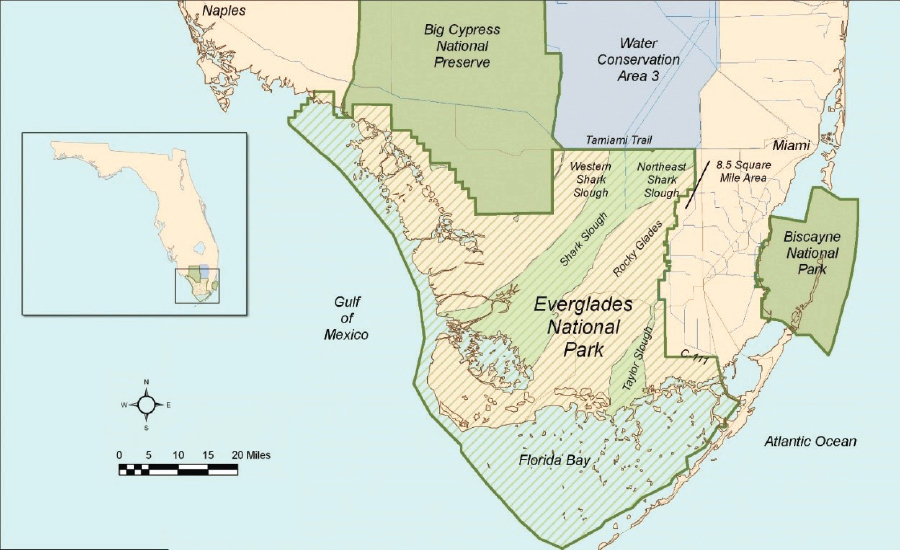
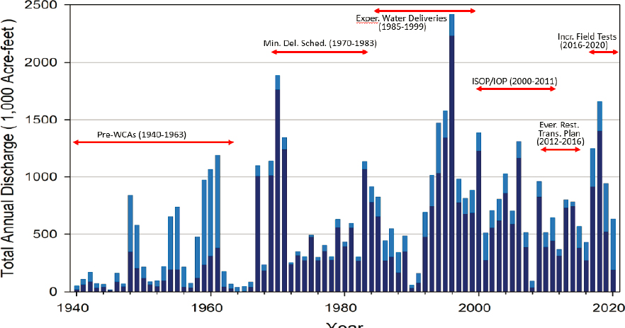
Prior to the construction of the WCAs, approximately two-thirds of the flow into Shark Slough came through Northeast Shark River Slough based on the natural gradients in the system (Figure 4-2). After development of the WCAs in the mid-1960s, conditions in Western Shark River Slough became much wetter (90 percent of total flow) and Northeast Shark River Slough much drier (10 percent of total inflow; Figure 4-3), producing a myriad of adverse ecological effects. For example, tree islands in Northeast Shark River Slough were lost because of peat oxidation caused by fires and lack of water (Sklar and van der Valk, 2002). These ecological impacts were recognized, and a series of actions were taken in the 1970s and 1980s in an attempt to alleviate the effects of an extended drought on Everglades National Park and reduce environmentally damaging releases of water into Western Shark River Slough. These actions included regulations requiring delivery of more water to Everglades National Park, changes in flow management, and enlargement of canals, but they proved to be inadequate (Table 4-1). For example, the Experimental Water Deliveries program (1983-1999) was able to deliver only a slight increase in flows into Northeast Shark Slough (Figure 4-3) due to flood mitigation constraints protecting residences in the 8.5 square-mile area (Figure 4-1). Thus, conditions remained too wet in Western Shark River Slough compared to historic conditions, and too dry in Northeast Shark River Slough (Van Lent et al., 1999), and ecological degradation continued.
The limitations of this water management regime resulted in a crisis when record high rainfalls subsequent to Hurricane Andrew in 1992 and large regulatory releases through the S-12 structures into West Shark River Slough in
SOURCE: https://www.nps.gov/ever/learn/nature/upload/RestorationFactSheet%20Lo%20Secure.pdf.
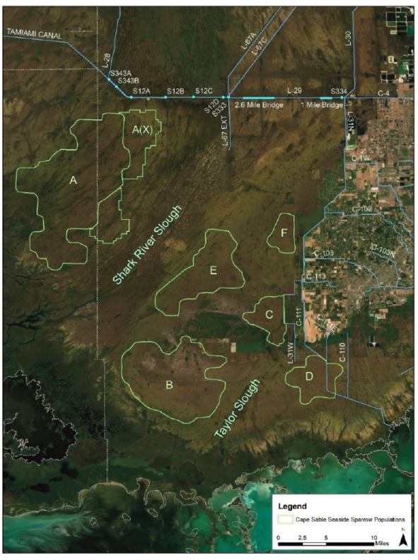
1993-1995 nearly extirpated subpopulation A of the endangered Cape Sable seaside sparrow (CSSS), which had formerly been the largest of the six CSSS subpopulations (Figure 4-4). In response to these impacts on the CSSS, the U.S. Fish and Wildlife Service (FWS) issued a Jeopardy Opinion on the Experimental Water Deliveries Program in 1999, effectively ending the program and necessitating the development of new water management. That the CERP was authorized immediately following this crisis is not coincidental.
The Everglades National Park Protection and Expansion Act of 1989 authorized Mod Waters and directed the U.S. Army Corps of Engineers (USACE) in consultation with the Department of the Interior to improve water deliveries into Everglades National Park and, to the extent practicable, take steps to restore natural hydrologic conditions in the park while maintaining flood protection of and water supply to the built environment (Public Law 101-229; NRC, 2008). The changes to hydrology outlined in the Mod Waters plan (USACE, 1992) to meet this mandate were much the same as those required to address the legal issues
SOURCE: R. Johnson, National Park Service, personal communication, 2020.
with the endangered CSSS, including shifting flows from Western to Northeast Shark River Slough. Thus, the ecosystem restoration goals of Mod Waters aligned with the legal requirements for endangered species management subsequently imposed in 1999.
Following the demise of the Experimental Water Deliveries Program and while construction of Mod Waters continued, water management at the boundary of WCA-3A and Everglades National Park was governed by interim operational plans1 to protect the CSSS. These operations plans suffered from the same flood risk management constraints that compromised the Experimental Water Deliveries Program and thus fared little better in increasing flows to Northeast Shark River Slough (Figure 4-3). In addition, with limited water conveyance capacity into Northeast Shark River Slough, closure of the S-12s to protect the sparrows adjacent to Western Shark River Slough under the interim operational
___________________
1 The Interim Structural and Operational Plan was implemented in 2000 followed by the Interim Operational Plan (IOP) in 2002.
TABLE 4-1 Timeline Leading to Initial Authorization and Preliminary Plans for the Mod Waters Project
| Date | Event | Purpose |
|---|---|---|
| 1960s | Extended historic drought affects Everglades National Park (ENP) | |
| 1968 | ENP South Dade Conveyance System (Flood Control Act) | Enlargement of the L-31N and C-111 canals to supplement water deliveries to South Dade and ENP |
| 1970 | Minimum Water Delivery Schedule (Public Law 91-282) | Required a minimum of 315,000 acre-feet of water deliveries to ENP each year, with a fixed monthly allotmenta |
| 1983 | ENP Seven-Point Plan issued | ENP recommendations to reduce the impacts of high S-12 regulatory flows on West Shark River Sloughb |
| 1983-1999 | Experimental Water Deliveries Program (Public Law 98-181) | Test different water delivery schedules to restore more normal flow, especially in Western and Northeast Shark River Slough |
| 1989 | ENP Expansion Act (Public Law 101-229) | Acquire 109,000 acres in Northeast Shark River Slough; authorized Mod Waters and C-111 projects |
| 1992 | General Design Memorandum (GDM) for Mod Waters finalized (USACE, 1992) | Restore historic flow-way between WCA-3A, WCA-3B, and Northeast Shark River Slough and relieve high flows from WCA-3A to Western Shark River Slough. The plan aimed to deliver 55 percent of the total flow volume east of L-67 to reflect historic flow paths |
a 260,000 acre-feet delivered to West Shark River Slough, and 55,000 acre-feet delivered to Taylor Slough and Eastern Panhandle basins.
b The seven points included (1) fill in the L-28 and L-67 ext. canals and remove the levee (promote sheet flow); (2) gap the L-67A and L-67C levees (promote sheet flow and restore flows through WCA-3B); (3) redistribute West Shark Slough inflows along the full length on the Tamiami Canal (L-28 to L-30); (4) establish a bimonthly water quality monitoring program for ENP (Memorandum of Understanding with the U.S. Army Corps of Engineers/South Florida Water Management District); (5) defer implementing a proposed drainage district in the East Everglades; (6) field test a rainfall-based water delivery schedule for the WCAs and ENP; and (7) suspend minimum water delivery schedule (Light and Dineen, 1994).
plans exacerbated high water levels during wet conditions in southern WCA-3A. Thus, these plans both failed to significantly address ecosystem degradation in Everglades National Park and worsened problems in WCA-3A, producing adverse effects on ridge-and-slough topography, tree islands, and another endangered bird, the snail kite. Furthermore, constraints on flows to the south during high water conditions necessitated release of water from Lake Okeechobee through the northern estuaries, resulting in adverse ecological effects there.
Analyses indicated that the systemwide hydrology envisioned in the CERP would provide for both CSSS and snail kites, as well as other avian species that are conservation priorities, such as roseate spoonbills, wood storks, and other wading birds (SEI, 2007). In keeping with this vision, a multispecies approach to integrate the needs of these avian species in WCA-3A and Everglades National Park (FWS, 2010) was incorporated into new water management operations—
SOURCE: Meyers, 2019.
the ERTP—implemented in 2012. Like the operations plans that preceded it, the ERTP attempted to improve hydrologic conditions in the central Everglades within the constraints of existing infrastructure, specifically by shifting flow from Western to Northeast Shark Slough, increasing flows into Everglades National Park, and reducing ponding of water in southern WCA-3A. These hydrologic goals are consistent with those of Mod Waters and the CERP. However, the ERTP proved little more effective in reaching these objectives than previous plans, and
conditions in Western Shark Slough continued to be too wet while Northeast Shark River Slough remained too dry (Figure 4-3). In 2016, the U.S. Fish and Wildlife Service issued a Jeopardy Opinion on the impact of the ERTP on the CSSS (FWS, 2016a).
As of 2016, little progress had been made in restoring the central Everglades through operational refinements using existing infrastructure. The COP, which employs the features constructed under Mod Waters and C-111 South Dade, went into effect in August 2020 and is expected to be a major step toward restoring the central Everglades, making substantive progress toward the goals of the CERP for this region. Two features of Mod Waters are especially critical to the capacity of the COP to achieve this. First, Tamiami Trail was raised to a design high water level of 8.5 feet National Geodetic Vertical Datum of 1929 (NGVD) in the L-29 Canal (compared to 7.5 feet under prior conditions). This increased elevation, combined with the 1-mile bridge constructed through Mod Waters and the 2.6-mile western bridge constructed through Tamiami Trail Next Steps, enables increased flows into Northeast Shark River Slough and Everglades National Park. Second, seepage management and flood mitigation features, including the S-356 pump station, acquisition of roughly one-third of the 8.5 square-mile area, and construction of a levee to protect the remainder of this area from flooding (Figure 4-1), were constructed to limit flood risk management constraints on the eastern boundary. The COP represents not only the final action that completes Mod Waters but also is envisioned to be the solution to the legal issues related to protection of endangered CSSS that have plagued water management at the boundary of WCA-3A and Everglades National Park for 25 years (FWS, 2016a).
C-111 South Dade and Taylor Slough
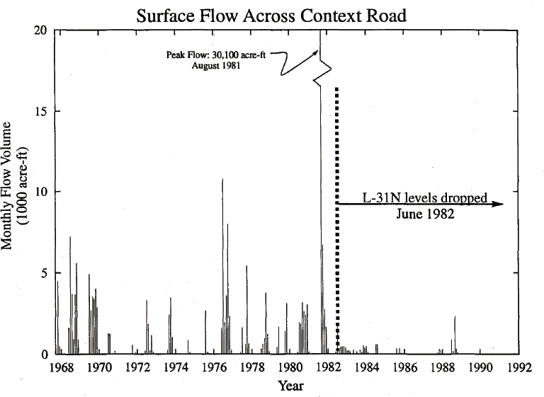
The C-111 Canal was constructed in the 1960s as part of the Central and Southern Florida Project to provide flood protection to agricultural lands east of Everglades National Park. The canal system also drained the eastern side of Everglades National Park, causing reduced hydroperiods and flows in Taylor Slough and high freshwater canal discharges into Manatee Bay and Barnes Sound (Figure 4-1). The reduction in flows through Taylor Slough was exacerbated in the 1980s by reductions in the L-31N Canal stage to reduce flooding in the lands to the east (Figure 4-5). Adverse effects of altered hydrology included reduced salinity in Manatee Bay and Barnes Sound due to freshwater discharges, and high salinity in Florida Bay and degradation of marl prairies inhabited by CSSS due to reduced inflows from Taylor Slough (Figure 4-4). The poor performance of the CSSS subpopulations near Taylor Slough was a component of the Jeopardy Opinion issued for the ERTP in 2016 (FWS, 2016a).
SOURCE: Van Lent et al., 1993.
In 1994, the C-111 South Dade Project was developed to include environmental restoration among the objectives of water management in the C-111 Basin (USACE, 1994). The objectives of the C-111 South Dade Project are to reduce freshwater canal discharges to Manatee Bay and Barnes Sound and restore hydrologic conditions in Taylor Slough and the Eastern Panhandle of Everglades National Park, thereby increasing overland flows to northeastern Florida Bay, while continuing to honor flood risk management constraints for the agricultural lands east of the park (USACE and SFWMD, 2020c). Seepage reduction is the primary means to accomplish the project objectives and is accomplished by constructing large detention areas and pump stations to create a hydraulic ridge between Everglades National Park and the agricultural lands to the east (Figure 4-1). The C-111 (Western) Spreader Canal CERP Project (see
Chapter 3 and Figure 4-1) extends the hydraulic ridge southward and was functionally completed in early 2012, but its operations are not impacted by the COP.
DEVELOPMENT OF THE COP
Once finalized, the COP will serve as the operational plan for the features of both recently completed pre-CERP foundation projects, Mod Waters and C-111 South Dade, superseding past basin-specific operational plans. The COP represents the first opportunity to employ all of the features of these projects to accomplish their objectives.
The stated objectives of the COP are primarily ecological (see Box 4-1). Achieving these objectives is subject to a variety of constraints, of which two related to flooding were of primary concern. In the 8.5 square-mile area the constraint required no increase in periodic flooding of lands within the levee over pre–Mod Waters baseline conditions, based on the Everglades National Park Protection and Expansion Act of 1989 (Public Law 101-229). Additionally, the COP must not exceed the level of flood risk defined as the 1994 baseline condition for the C-111 Basin (east of the L-31 Canal), which was set forth in the USACE Environmental Impact Statement (USACE, 1994) and codified in the Water Resources Development Act of 1996 (Public Law 104-303). The formulation of the COP also considers “concerns” and “planning considerations.” Concerns are aspects of the system that water managers want to maintain or improve upon rather than adversely affect. These include water supply, groundwater, fish and wildlife, and recreation. Planning considerations included ensuring compatibility
of the COP with the CEPP, maintaining multispecies objectives established in the ERTP, maintaining water quality, and exploring opportunities to enhance flood mitigation, among others. Planning considerations and concerns were addressed in a variety of ways that differed greatly in the level of analysis and methodology.
Field Testing
The development of the COP was informed by data gathered during a period of incremental operational testing, beginning in 2015 (see Box 4-2). The incremental field tests were designed to assess the hydrologic response to operations of the Mod Waters structures, including the capacity of the new seepage control
infrastructure around the 8.5 square-mile area to accommodate higher flows in Northeast Shark River Slough. Key features of the field tests were relaxing existing flood risk management constraints on gage G-3273 related to flow from WCA-3A into Northeast Shark River Slough (Figure 4-1) and incrementally increasing the stage in the L-29 Canal from 7.5 feet NGVD in Increment 1 to 8.5 feet NGVD in Increment 2. Operations were interrupted repeatedly during the field tests by temporary emergency deviations due to high-water conditions, such that the system operated as specified for the different increments only 54 percent of the time from its initiation through April 2019.
These field tests revealed difficulties in flood management in the 8.5 square-mile area, which led to modifications of operations of subsequent increments (Box 4-2). Extending the duration of operations above 8.3 feet NGVD (Increment 2) requires demonstrating that flood risk management constraints can be maintained for Tamiami Trail roadway protection and in the 8.5 square-mile area. USACE (2020b) noted that compliance with this constraint has not yet been demonstrated. This impasse and the modifications to operations that occurred in Increment 1 due to flooding indicate that flood risk management for the 8.5 square-mile area remains, as it has for decades, a large constraint on flow to Northeast Shark River Slough, despite the new infrastructure added in Mod Waters.
Process for Selecting Among Alternatives
The development of the COP followed the standard USACE planning process. The planning approach employed used a combination of modeling, elicitation from experts, inference based on recent historical observations of flow, and, in some cases, physical experimentation. Alternatives were developed in a series of workshops, beginning with a set of extreme alternatives that either prioritized environmental restoration objectives or prioritized flood risk management. Learning from incremental field testing (Box 4-2), which occurred since 2015 amidst substantial variability in water levels, including high-water years, also informed the development of alternatives. Using model-based analysis, planning objectives, constraints, and planning considerations were applied to score the initial list of candidates and screen alternatives. Three alternatives emerged (Alternatives K, L, and N), which, respectively, emphasized flood mitigation for South Dade, providing the most flows into Northeast Shark River Slough, and balancing each. Results were reviewed and evaluated by subteams representing ecological, flood risk, water quality, and water supply issues.
The performance of a narrowed list of COP alternatives was compared in three rounds of hydrologic modeling and compared against an existing-condi-
tions baseline (ECB19RR). The baseline represents the approved operational plan at the time of implementation of the COP. Under this baseline (ECB19RR), the Mod Waters and C-111 South Dade infrastructure is in place, and it incorporates operational enhancements mandated by the 2016 ERTP biological opinion that were evaluated in the Increment 1.1 and 1.2 field tests. Alternatives K, L, and N were evaluated in round one, and in the second round, a refined set of three alternatives (N2, O, and Q) were compared (see USACE [2020b] for details). Each of these alternatives satisfied constraints identified at the outset of the planning process, while differing with respect to rules for water deliveries to Everglades National Park, flood mitigation operations within the 8.5 square-mile area, provision of flows to Taylor Slough, operation of S-197, and protocols during high-water conditions within WCA-3A. Modeling in the second round included six ecological models in addition to the hydrologic models used in round one. In a third round, additional model-sensitivity runs were performed to further refine the alternatives, leading to the development of Alternative Q+, the preferred alternative.
The process-related decisions for evaluating a preferred alternative include the selection of performance metrics, the models used for evaluating the alternatives, the scenarios over which alternatives will be evaluated, and the criteria for selecting a preferred alternative based on the modeling results. The team used a consultative process to transparently communicate its approach and invited comment on its evaluations from federal agencies, affected Indian Tribes, state and local agencies, and other interested parties. Two sets of performance metrics were selected, one by an ecological subteam and one by a flood risk subteam, and these included systemwide metrics previously used by RECOVER and others previously used by the CERP. The relationship between the COP project objectives and the performance metrics, however, is not entirely clear. For example, the COP objectives (Box 4-1) are all ecological, but flood risk management over and above that required to meet constraints was a factor used extensively in alternative development and figured prominently in the evaluation of alternatives. The seemingly overlapping definitions of planning objectives, constraints, and considerations used to evaluate alternatives makes it difficult to understand whether objectives remained the primary factors in alternative selection or were subjugates to constraints or considerations unrelated to the objectives.
Established regional hydrologic models (Regional Simulation Model [RSM] application for the Glades-Lower East Coast Service Area [RSM-GL]) was used to estimate the performance metric values for each alternative for a historical 41-year simulation period (1965-2005). For some performance measures, the Miami-Dade [MDRSM] model was applied to examine in higher spatial and temporal detail performance in 3 years—a wet (1995), a dry (1989), and an
average year—and compared to baselines related to previous flood protection agreements. Performance of alternatives was not evaluated for changes in precipitation frequency and occurrence, either due to natural variability or climate change, or the implications of sea-level rise that might occur in the period of implementation of the COP. The model results have not been transparently compared to observations in the COP analysis, so the error and uncertainty inherent in the model output relative to the effect of COP alternatives is unclear.
The selection of the preferred alternative involved iterative improvement of intermediate alternatives based on multiobjective trade-off analysis that used a number of the performance metrics to compare the performance of the alternatives. The trade-offs between objectives were not presented and the process for selecting among objectives not explicitly reported, nor was the weight given to planning considerations clear. In particular, while achieving a mandated baseline level of flood risk management was a clear constraint, the planning consideration of enhanced flood mitigation also appeared to play an important, unspecified role, with preference for plans that provided additional flood risk management benefits.
The Preferred Alternative
The preferred Alternative Q+ incorporates various operational features to increase the flow of water across the northern boundary of Everglades National Park. The details of the operational plan are outlined in USACE (2020b, Table 2-2). Among the operational changes, water deliveries from WCA-3A to Everglades National Park will be regulated according to the newly developed Tamiami Trail Flow Formula (TTFF; SFWMD, 2019b). The TTFF is a multiple linear regression that predicts target water releases at S-12C, S-12D, and S-333 from WCA-3A into Everglades National Park from state variables of the system (previous flow, precipitation, potential evapotranspiration, and storage levels in WCAs). The peak stage in the L-29 Canal will be 8.3 feet, with the added provision of operating L-29 at 8.5 feet for up to 90 days per calendar year. The preferred alternative includes the capability to further extend and/or remove the cumulative duration criteria for operating the L-29 Canal above 8.3 feet NGVD, while continuing to adhere to the maximum operating stage limit of 8.5 feet NGVD, Tamiami Trail roadway protection, 8.5 square-mile area flood mitigation, and consideration of low-water stages within WCA-3A. The preferred alternative removes the G-3273 stage constraint that formerly triggered cessation of S-333 discharges into Everglades National Park. While enhancing flow into Northeast Shark River Slough, Alternative Q+ reduces flows into Western Shark River Slough and incorporates the reasonable and prudent action of the 2016 ERTP biological
opinion for extended closure periods of the S-12 structures to mitigate high-water conditions that threaten CSSS habitat (FWS, 2016a).
To the east of the park under the preferred plan, stages in the C-111 Canal and in L-31 reaches south of the 8.5 square-mile area will be lowered compared to 2002-2015 operating levels. Water-detention areas will no longer have operational stage constraints; when filled, the detention areas create a hydraulic ridge to lower seepage losses from Everglades National Park and increase water flows in Taylor Slough. Alternative Q+ also modifies the operational criteria for the C-111 structure S-197 for the purposes of reducing freshwater discharges to Manatee Bay.
BENEFITS EXPECTED FROM THE COP
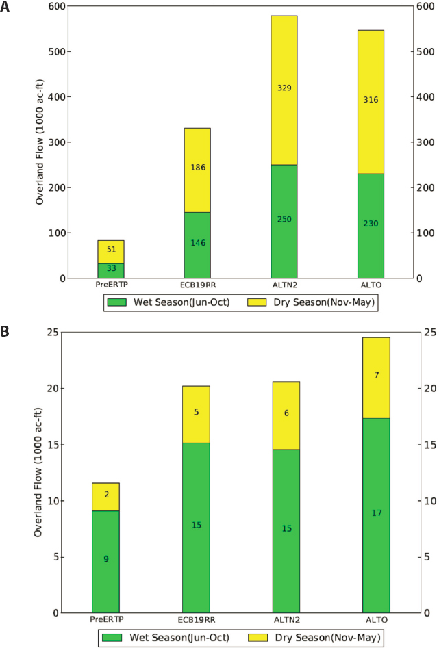
The COP Environmental Impact Statement (USACE, 2020b) estimates benefits by comparing conditions under Alternative Q+ to an existing-conditions baseline (ECB19RR), which is intended to represent the approved operational plan at the time of implementation of the COP in 2020. Because infrastructural and operational improvements from Mod Waters and C-111 South Dade are embedded into ECB19RR, USACE (2020b) only quantifies a portion of the benefits provided by this infrastructure. For example, model-simulated, average annual flows across a transect in Northeast Shark River Slough were three times greater under ECB19RR than during pre-ERTP (prior to 2012) conditions, while overland flow in the headwaters of Taylor Slough were nearly twofold greater for ECB19RR than for pre-ERTP (Figure 4-6) (W. Wilcox, South Florida Water Management District [SFWMD], personal communication, 2020). In the examples shown in Figure 4-6, the baseline accounts for roughly half of the benefit projected for the COP alternatives plotted relative to pre-ERTP conditions. No information is available for COP benefits from Alternative Q+ relative to pre-ERTP conditions; therefore, the benefits described in the environmental impact statement and summarized in the next paragraphs should be considered an underestimate of the full hydrologic lift provided by the recently constructed Mod Waters and C-111 South Dade infrastructure that falls under the scope of the COP. Although the methodology for calculating benefits is reasonable for selecting a preferred alternative, the agencies missed an opportunity to broadly communicate the benefits derived from several decades of restoration investments.
Hydrologic Benefits
Implementation of Alternative Q+ is predicted to increase average annual flows across Tamiami Trail and into Everglades National Park by 28 percent
SOURCE: W. Wilcox, SFWMD, personal communication, 2020.
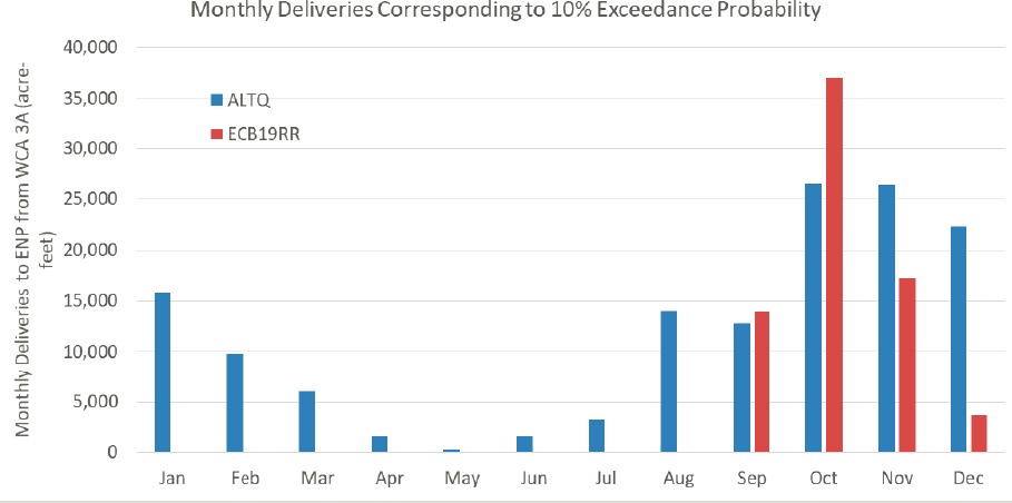
relative to the no-action alternative (ECB19RR), while increasing the proportion of flow that enters Northeast Shark River Slough (east of S-333) from 58 to 77 percent. The increase in flows across the trail will be accompanied by longer hydroperiods within the Everglades National Park, particularly in Northeast Shark River Slough (Figure 4-7). Shifting more water to the east will lead to a closer approximation of historic flow patterns and is expected to improve ecological conditions in Northeast Shark River Slough. Water deliveries from WCA-3A to Everglades National Park are expected to yield the greatest improvements during extremely dry conditions, when flows to the park would cease under ECB19RR (Figure 4-8).
Alternative Q+ provides additional operational flexibility through inclusion of special management protocols triggered by exceedance of an extreme high-water limit in WCA-3A. Since 2015, unusually wet conditions have forced the USACE to seek two emergency deviations from the 2012 water control plan, which required the State to gain permission from potentially impacted land owners to flow additional water across their property and to conduct an environmental assessment of the effects of the flow deviation. The extreme high-water limit in the COP is intended to streamline the process required to implement actions to respond to high-water conditions, alleviating additional National Environmental Policy Act (NEPA) reviews. It also allows flows to bypass Everglades National Park and be routed through the South Dade Conveyance System and released through S-197 to Manatee Bay. Although expected to be triggered infrequently, the extreme high-water limit would help protect the WCA-3A perimeter levee system, reduce the risk of flooding to hurricane-evacuation routes, and lower the threat of high-water conditions to wildlife and tree islands inside WCA-3A.
Flows into the Eastern Panhandle of Everglades National Park and Taylor Slough will also increase under Alternative Q+. The increase is comparatively small for Taylor Slough, equaling 6,000 acre-feet (AF) per year on average, or 7 percent above the no-action alternative (ECB19RR), but is more substantial for the Eastern Panhandle, where annual inflows are forecast to increase by 30,000 AF per year on average (or 27 percent) over the baseline. These additional flows are gained, in part, by reducing discharge through S-197, which has the beneficial effect of lowering excessive freshwater releases to Manatee Bay and Barnes Sound by 41,000 AF per year (69 percent) compared to the no-action alternative.
Compared to the no-action alternative, Alternative Q+ is projected to increase freshwater flows into Florida Bay by 36,000 AF per year, with the greatest increases in overland flow occurring through the Eastern Panhandle to the eastern basins of Florida Bay (see also Chapter 5). Nevertheless, seasonal
SOURCE: USACE, 2020b.
SOURCE: USACE, 2020b.
deliveries of overland flow to the Florida Bay under Alternative Q+ will remain well below those typical of the natural system (see Chapter 5). Mod Waters and C-111 South Dade do not provide new storage; instead, the COP redistributes the existing water budget while remaining compatible with flow increases expected from future CERP projects.
Benefits to Vegetative Communities
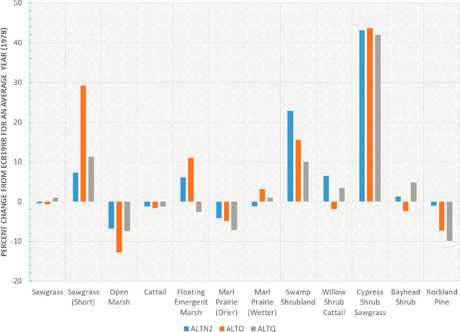
Hydrologic changes induced by implementation of the COP will promote ecological responses. Increases in hydroperiod within Northeast Shark River Slough and Taylor Slough are expected to reduce soil-oxidation rates, thereby promoting accretion of peat. Predictions made with the Everglades Landscape Vegetation Succession Model (ELVes) suggest that changes in the patterns and timing of inundation will lead to modest responses in the vegetative community. During an average rainfall year, for example, minor to moderate changes (< 10%) are predicted for the aerial extent of floating emergent marsh vegetation, cattails, and marl prairie vegetation relative to ECB19RR (Figure 4-9). Calculations
SOURCE: USACE, 2020b.
of a slough-vegetation performance index2 were made to assess the hydrologic suitability for slough communities under the COP. Estimates of this performance measure are similar for the no-action and Alternative Q+ scenarios for areas west of the Miami Canal in northern WCA-3A, although Alternative Q+ scores are slightly lower than the no-action alternative or Alternative O in the remaining portion of WCA-3A and WCA-3B. Within Everglades National Park, Alternative Q+ performed better for the index in Northeast Shark River Slough and southern
___________________
2 The slough-vegetation performance measure was based on optimal hydrologic conditions to promote white water lily and bladderwort, which historically dominated Everglades sloughs under predrainage conditions.
Taylor Sough, but worse than Alternative N2 in central Shark River Slough. Tree island inundation is also reduced by the COP; the number of tree islands minimally inundated (for less than 10 percent of the period of record) is projected to increase by 24 percent for Alternative Q relative to ECB19RR, with the benefits concentrated in WCA-3 (USACE, 2020b).
Benefits to Endangered Birds
The COP aligns with the Reasonable and Prudent Alternative to ERTP to address the adverse effects of water management on endangered species articulated in the 2016 Jeopardy Opinion (FWS, 2016a). The USACE (2020b) concluded that the COP “may affect, but is not likely to adversely affect” most endangered and threatened species, including panthers, manatees, an endangered bat, alligators, and crocodiles, meaning that “all effects are beneficial, insignificant, or discountable.”3 This conclusion appears reasonable, and indeed the FWS accepted this conclusion in a concurrence letter issued in March 2019. The USACE entered into formal consultation with FWS on three species—wood storks, snail kites, and CSSS—for which the Corps makes a “may affect” determination. These are the same three species that were the basis of the Jeopardy Opinion and that have been the source of conflicts between water management and endangered species management in the central Everglades since the mid-1990s. In this section, the committee assesses the impact of the COP on these species based on information provided in the COP Draft Environmental Impact Statement (USACE, 2020b) and supporting documents and discusses the ramifications for integrating restoration and endangered species conservation.
Wood Storks and Snail Kites
In its 2016 Jeopardy Opinion, the FWS concluded that the ERTP did not jeopardize snail kites or wood storks, or destroy or adversely modify their critical habitat (FWS, 2016a). The COP is projected to benefit these species relative to the ERTP; thus, there is little concern that protection of these species will pose any constraints in implementing the COP.
Wood storks.
Simulations using Wader Distribution Evaluation Modeling (WADEM) indicate that the COP will result in improved foraging conditions for storks over large areas of northern and northeastern Everglades National Park (USACE, 2020b). The primary concern about storks is that the COP may result in excessive drying in northeastern WCA-3A in dry years, which would expose nesting colonies to high levels of nest predation and adversely affect foraging
___________________
3 See https://www.fws.gov/midwest/endangered/section7/ba_guide.html.
conditions, particularly in the area of the Alligator Alley North supercolony. In the record nesting year of 2018, the number of wading bird nests in this colony exceeded the CERP goal for the entire Everglades ecosystem (USACE, 2020b) and accounted for 48 percent of all wading bird nests in the Everglades, making it the largest nesting colony observed since the 1930s (Cook and Baranski, 2019). The COP Adaptive Management Plan specifically addresses uncertainties in potential adverse impacts of the COP on the initiation and success of wading bird nesting and regional foraging conditions of this colony and in the project area generally (USACE, 2020b).
Snail kites.
Snail kites are highly mobile and move throughout the Everglades ecosystem to find conditions favorable for foraging and nesting. Snail kites forage in nearly continuously flooded wetlands with relatively sparse emergent vegetation where they feed on apple snails and nest over water to reduce predation. In the mid-1990s, WCA-3A was their primary nesting area, but restrictions in flows to Western Shark River Slough to protect CSSS resulted in water ponding in southern WCA-3A, exacerbating ongoing degradation of kite foraging habitat. As habitat conditions degraded, numbers of kites and kite nests declined and the distribution of nests shifted (NRC, 2012). By the late 2000s, there was almost no nesting in WCA-3A, and the kite population had declined to one of the lowest levels ever recorded. Since the late 2000s, nesting has shifted to the Kissimmee Chain of Lakes, Lake Okeechobee, stormwater treatment areas, and other locations, and the kite population has rebounded (Fletcher et al., 2019) (Figure 4-10). Conditions for kites in the central Everglades continued to decline under the ERTP (FWS, 2016a), and kite nesting in the central Everglades, as a whole, remains minimal (Fletcher et al., 2019). The primary benefit to kites of the COP likely will be reduction of ponding of water in their former nesting area in southwestern WCA-3A. Otherwise, ecological modeling suggests that the COP will not significantly improve conditions for kites (USACE, 2020b).
Based on the slight improvements in conditions for snail kites in the central Everglades, a major revival of kite nesting in WCA-3A or elsewhere in this region should not be expected. The return of hydrologic and ecological conditions that support kite foraging and nesting in the central Everglades may remain a kite recovery goal, but, thanks to the resiliency of this species, the survival of the snail kite is no longer jeopardized by failure to meet this goal. Unlike 20 years ago, kites now are doing well elsewhere in the Everglades ecosystem, where they feed on invasive as well as native apple snails and nest in a variety of locations. Hence, management of endangered snail kites does not pose a serious constraint on the COP.
SOURCE: Fletcher et al., 2019.
Cape Sable Seaside Sparrows
In many respects, integrating restoration of the central Everglades with management of endangered CSSS in the COP is a demonstration of the balancing among objectives that will be required for the full operation of the CERP. For the past 20 years, failure to protect the CSSS has forced water managers to alter operations designed to accomplish restoration. To prevent the COP from suffering the same fate as Experimental Water Deliveries and ERTP, it will be necessary to avoid exceedances established for incidental take for the CSSS. The poor current condition of the CSSS population, combined with impacts of the redistribution of water under the COP at the local scale, makes this very challenging.
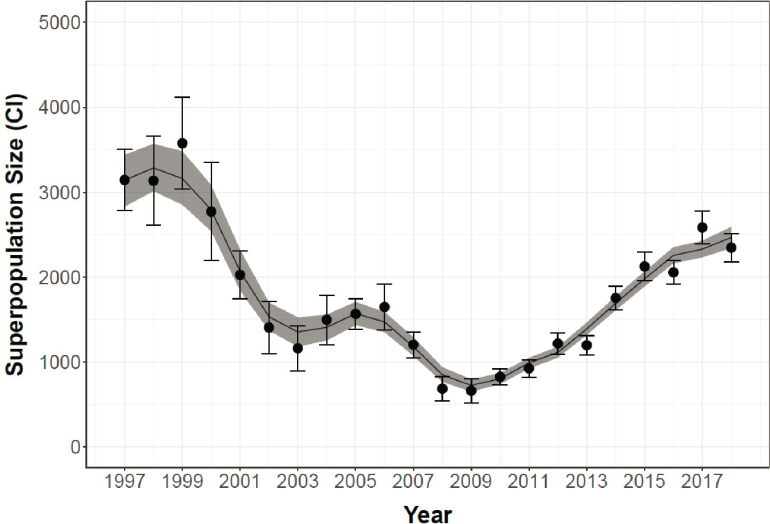
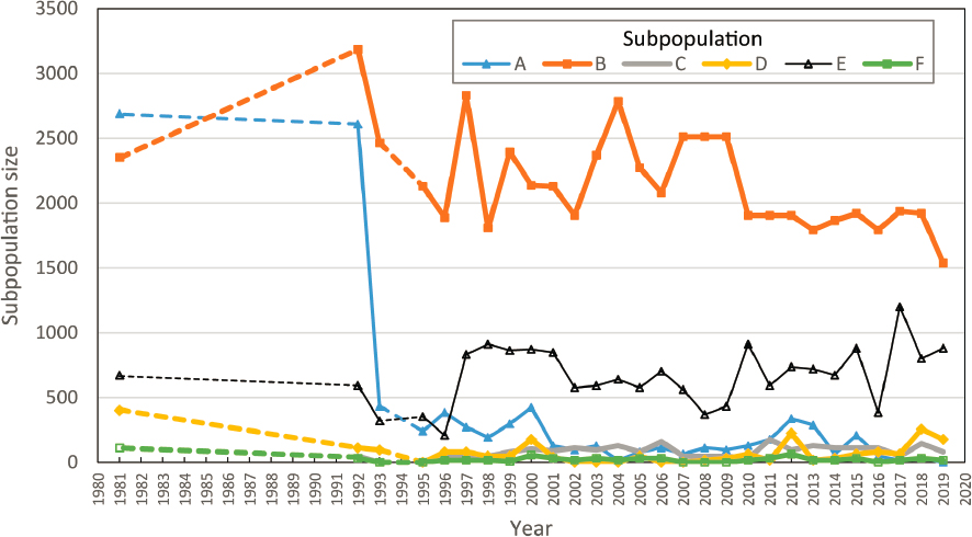
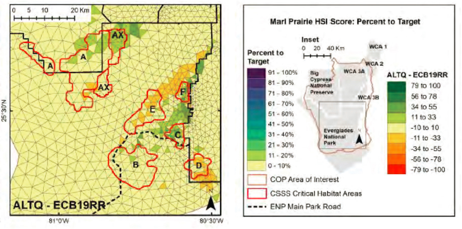
The CSSS population, as of 2019, consists of one large (B), one medium (E), and four small (A, C, D, and F) subpopulations and an estimated total population of 2,688 birds (Figures 4-4 and 4-11). Subpopulations C, D, F, and, likely,
SOURCE: Based on data in FWS, 2020.
A are even less productive than their small size suggests due to breakdowns in population dynamics and may be on the verge of functional extirpation (FWS, 2016a; Slater et al., 2014). The Reasonable and Prudent Alternative on which the COP is based calls for demonstration of progress toward several population goals including a trend toward positive population growth for 10 years, a total population size > 6,600 for 5 years, a subpopulation A size of 2,100, and establishment of three self-sustaining, stable subpopulations (FWS, 2016a). It also includes a minimum total population size requirement of 2,281. It will be difficult to achieve progress toward the population goals and avoid violating this minimum population size requirement and thus triggering more consultation.
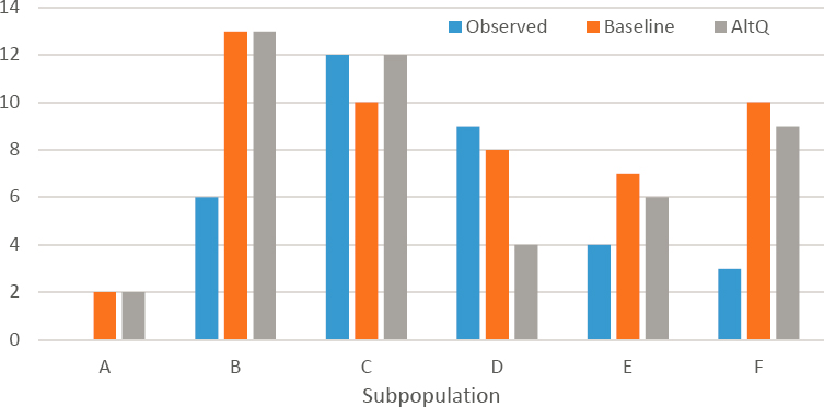
Based on modeling results using climate data from 1965 to 2005, USACE (2020b) presents information on the performance of the COP and its baseline in meeting hydrologic targets for sparrows in each of the subpopulations. Overall, the effects of the COP relative to the baseline are relatively small, with the exception of subpopulations D and E, which are getting much wetter under COP. The COP is projected to reduce the number of years that meet the hydroperiod target of 90-210 days in at least 40 percent of the habitat used by each subpopulation
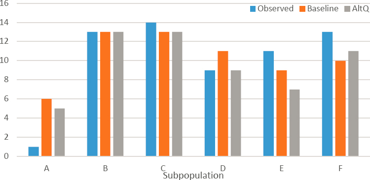
by 57 and 23 percent for subpopulations D and E, respectively. These areas also showed the largest reductions in the number of years that at least 90 dry nesting days occurred over 40 percent of the habitat (see Tables 4-2 and 4-3). Table 4-2 also shows that the overly wet hydrologic conditions for subpopulation A remain about the same under the COP.
Although modeling data are not available to compare the COP to the ERTP or pre-ERTP conditions, one can estimate the effects of implementation of the Mod Waters and C-111 South Dade infrastructure by comparing the COP modeled output for 1992-2005 to the observed conditions for the same period based on data of FWS (2016a). Issues such as model bias make comparisons of modeling
TABLE 4-2 Baseline and Alternative Q Performance Relative to the CSSS Criterion of 4-Year Running Average Hydroperiods Within the Range of 90-210 Days over 40 Percent of the Habitat Based on 1965-2005 Climate Data
| Subpopulation | Average mean 4-year hydroperiod ± standard deviation | Years that at least 40% of habitat met target for 4-year running average hydroperiod | ||
|---|---|---|---|---|
| ECB19RR | ALT Q | ECB19RR | ALT Q | |
| A/Ax | 242 ± 56 | 243 ± 57 | 7 | 8 |
| B | 146 ± 52 | 148 ± 52 | 35 | 34 |
| C | 102 ± 57 | 109 ± 55 | 19 | 21 |
| D | 188 ± 46 | 214 ± 50 | 28 | 12 |
| E | 204 ± 64 | 217 ± 65 | 22 | 17 |
| F | 136 ± 72 | 152 ± 75 | 24 | 23 |
NOTE: Green denotes average hydroperiod within the desired range of 90-210 days.
SOURCE: Data from USACE, 2020b.
TABLE 4-3 Baseline and Alternative Q Performance Relative to the CSSS Criterion of > 90 Dry Nesting Days over 40 Percent of the Habitat Based on 1965-2005 Climate Data
| Subpopulation | Average percent of habitat meeting >90 consecutive dry days | Years that at least 40% of habitat met target | ||
|---|---|---|---|---|
| ECB19RR | ALT Q | ECB19RR | ALT Q | |
| A/Ax | 46.2 | 44.2 | 20 | 18 |
| B | 76.6 | 75.5 | 37 | 35 |
| C | 83.9 | 87.3 | 36 | 36 |
| D | 53.2 | 46.0 | 24 | 21 |
| E | 57.7 | 50.0 | 27 | 23 |
| F | 70.8 | 69.1 | 30 | 30 |
SOURCE: Data from USACE, 2020b.
results to real data challenging, and these comparisons assume the model errors for the comparison period are small relative to the size of the effects. Nevertheless, these comparisons provide an approximation of how hydrology will differ from previous conditions under COP. Figures 4-12 shows that improvements in hydroperiods primarily are due not to Alternative Q+ but to operational changes made though Increment 1.2 (the COP baseline, ECB19RR), particularly for subpopulations B and F, which were overly dry areas. A small hydroperiod benefit, as well as an increase in the occurrence of > 90 dry nesting days over 40 percent of the habitat, attributable to the Increment 1.2 baseline is observed for the problematic, overly wet subpopulation A (Figure 4-13). These comparisons reinforce modeling results indicating that some subpopulations (D, E) may fare worse under Alternative Q+ and further suggest that habitat conditions, particularly for nesting, might be little improved or even poorer under COP than under pre-CERP water management (Figure 4-13).
These and other results presented in USACE (2020b) suggest that restoring the historic distribution of flow between Western and Northeast Shark Slough, although beneficial to sparrows at a large scale, will not necessarily resolve
SOURCE: Data from USACE (2020b) and FWS (2016a).
the issues that have led to multiple jeopardy opinions over the past 20 years. Although the COP will improve conditions for subpopulation A, conditions will remain too wet in most years relative to target conditions for nesting (Figure 4-13). Increased flows to Northeast Shark Slough and Taylor Slough will produce a complex mix of improvements in some areas and adverse effects in others. This is not a surprise, as it mirrors results of modeling associated with the CEPP (FWS, 2014; USACE and SFWMD, 2014) previously reviewed by the committee (NASEM, 2016). Restoration of the central Everglades will create new CSSS habitat in some locations, and convert currently suitable marl prairie to wetter habitat types in others. Specifically for the COP, adverse effects are expected close to sloughs, and benefits farther away from sloughs (Figure 4-14). New habitat for subpopulation A will be created in the northern part of the area (Ax) known as the expansion area, which is already occupied by some sparrows. Modeling also indicates there will be a considerable area of suitable, currently unoccupied habitat between subpopulations B, C, and F, and a smaller amount northeast of F. Of concern are projected reductions in habitat for subpopulations D and E (the second largest) (Figure 4-14).
SOURCE: Data from USACE (2020b) and FWS (2016a).
SOURCE: USACE, 2020b.
The COP Biological Opinion.
In the Biological Opinion on the COP, which was released in May 2020, FWS (2020) concluded that the COP will not jeopardize the continued existence of CSSS, snail kites, or wood storks or adversely modify their designated critical habitat, and noted that the USACE will achieve all the actions and timelines of the Reasonable and Prudent Alternative described in the ERTP Jeopardy Opinion with the implementation of the COP. FWS defines incidental take, and criteria for exceedance of authorized take that could trigger reinitiation of consultation, for all three species. The analyses and conclusions presented in the Biological Opinion are similar to the committee’s independent assessment in most respects. However, FWS (2020) appears much more optimistic than the committee that the CSSS is unlikely to constrain the COP.
FWS relied on the same analyses in USACE (2020b) and performed the identical comparisons of observations to model projections (Figures 4-12 and 4-13) as the committee. It reached the same conclusions about much of the benefit from Mod Waters and C-111 South Dade to sparrows being captured in the ECB19RR baseline and modest benefits for the problematic subpopulation A. FWS (2020) noted the adverse effects on subpopulations D and E, reduced performance of Alternative Q+ compared to the baseline for these three subpopulations, and
projected creation of new sparrow habitat. However, FWS (2020) does not foresee the need for mitigation to redistribute sparrows on the landscape for the COP to remain in compliance with the Endangered Species Act with respect to CSSS. The estimated sparrow population in 2019 was 2,688 birds, based on 168 birds detected.4 The new incidental take exceedance criterion in FWS (2020) is a population size estimated from annual surveys of at least 2,387 birds. If 19 fewer birds are detected in a subsequent survey, authorized incidental take will be exceeded; the number of birds detected has differed from the previous survey by more than 19 birds in 7 of the past 9 years. Furthermore, in subpopulation A, which FWS views as critical to the continued existence of the sparrow (FWS, 2020), no birds were detected in 2019.
Active mitigation strategies.
Given the precarious state of the CSSS and the projected impacts of COP on subpopulations A, D, and E, the next water management crisis over the sparrow is likely to be triggered by adverse effects from the COP on existing sparrow habitat. One can imagine demands to constrain flows to Northeast Shark River Slough and Taylor Slough to protect the sparrow, impacting broader ecological restoration goals for the region. Active mitigation for sparrows is the key to integrating Everglades restoration goals with CSSS recovery. To offset adverse effects expected on some sparrow habitat, sparrows will need to be redistributed on the landscape, such that new subpopulations in new habitat more than compensate for any losses of sparrows in current habitat. This may require active measures such as translocation of sparrows to new habitat, rather than relying on the birds to colonize new areas. If the COP is to avoid the fate of previous water management plans, it would behoove managers to design and begin executing plans to establish sparrows in newly created habitat now rather than waiting for a crisis to force them to do so.
The COP provides the first opportunity to implement active mitigation strategies and, based on their results, develop a systemwide sparrow conservation plan for CERP. Thus, as with many other aspects of restoration, the COP provides an opportunity for adaptive management of CSSS recovery that has programmatic applications. Hopefully, it marks the beginning of the resolution of the constraints the CSSS has posed for water management, and the restoration.
Committee Evaluation of the Process
The process used to identify, evaluate, and select a preferred alternative for the COP was systematic and comprehensive. The evaluation used information from both field testing and modeling, with modeling playing a particularly central
___________________
4 The methodology for CSSS population assessments uses a multiplier of 16 for every bird counted in the field.
role in evaluation of final alternatives and development of the flow formula used to implement the final preferred alternative. The planning process also incorporated significant stakeholder input, which, although widely promoted, may nudge evaluation toward objectives that differ from the stated objectives (Layzer, 2008). Although there is much to praise in the COP formulation, evaluation, and selection process, future CERP operational evaluation would be improved by explicit consideration of uncertainty, transparency in the consideration of stated objectives, and evaluation of performance under future conditions. The following comments address points where the process could more fully follow best practice and be a true exemplar for future CERP project development.
Consideration of Model Uncertainty
The best practice approach in modeling is to characterize the uncertainty of the models being used (Lehrter and Cebrian, 2010; Rinderknecht et al., 2012; Ruppert et al., 2012). By doing so, one can produce a more realistic range of what the observed results are likely to be, given the uncertainty of the model. The implementation of the COP is enabled by the TTFF, a multiple linear regression model. The regression was created using the water releases from the iModel (Ali, 2015) and RSM-GL, which provide optimal releases for a specified objective function as the target. Linear regression has been used previously in water resources management for deriving reservoir operational rules from the results of optimization models (Lund and Ferreira, 1996). Using this technique for guiding operations requires an understanding of how different from the expected flow value the actual flow value might be when the operational rules are applied. For example, given particular values of previous flow, precipitation, potential evapotranspiration, and storage levels in the WCAs in a given time step, the TTFF produces a specified flow release target for S-12C, S-12D, and S-333. Decision makers need to know how well those release targets are likely to match the optimized targets and, consequently, how likely the releases are to meet the objectives that are sought (and expected). This is relevant for the COP but also relevant to the CERP more generally. To answer these questions, planners need to understand how likely it is that actual observed results of projects will be similar to the model-estimated results and how much error is tolerable without significant implications for achieving objectives. Since model-estimated results are often a primary input to project design, the answer to these questions has significant consequences for the success of CERP.
For example, in the case of the TTFF, a regression model produces a conditional mean estimate of the target flow release, which is used for operations, and also specifies the full uncertainty distribution for the flow (i.e., the range of
the flow values that the iModel could have produced for the current state of the state variables). The uncertainty analysis (see Appendix H, Annex 8 of USACE [2020b]) presents figures related to the errors of the regression, showing no reason to reject the model. This is good modeling practice and an example for model evaluation in all CERP projects. No such evaluation of error and range of uncertainty is provided for the RSM-GL, however, which was used for selecting the preferred alternative. In both cases, what this range of uncertainty implies for the selection of the COP alternative is unclear. This range of uncertainty in the TTFF may be within the range of difference in outcomes between the alternative plans. The possible range of outcomes for the performance metrics is also unknown. Selections among COP alternatives were made based on differences in the model results, but it is unclear whether the differences between alternatives were meaningfully significant relative to the model uncertainty. Despite the challenges in quantifying the implications of scientific uncertainty on restoration decisions (e.g., Estenoz and Bush, 2015), the presentation of uncertainty, such as the range of expected outcomes, helps to set more reasonable expectations. It also is essential for adaptive management, because when monitoring reveals observed performance metrics, one must know whether they fall within the range of expectations (which corresponds to the range of model uncertainty) or whether they are truly anomalous and indicative of a problem (see also Chapter 6).
Transparency of Multiobjective Trade-off Analysis
The process for selecting the preferred COP alternative was a systematic evaluation of alternatives using a set of performance metrics representing the multiple objectives for this project. Multiple performance metrics were considered, including both ecological performance and effects on flood risk, as well as considerations related to water quality and water supply. However, even though the objectives for COP were strictly ecological, it is not clear that the selected Alternative Q+ provides the most ecological benefit, particularly in comparison to Alternative O, and what role other factors, labeled planning considerations and concerns, played in project evaluation. Meeting previously defined levels of flood risk management was a mandated constraint on the COP, yet the planning consideration of enhancing flood mitigation also emerged as an important factor in alternative evaluation. If enhanced flood mitigation was provided at the expense of meeting ecological benefits, best practice would require that this was clearly laid out. Any differential weighting of planning considerations, like enhancing flood mitigation, also needs to be documented. Transparency on the trade-offs between objectives, and between objectives and planning considerations, would enable a clearer understanding of the selection process and the
extent that ecological targets were compromised due to other considerations. Perhaps there is a very limited trade-off and objectives move in concert. Through the use of trade-off curves, including parallel coordinates plots (Wegman, 1990), the process for selecting the final alternative can be made more transparent, providing better understanding for concerned stakeholders regarding why decisions were made as they were.
Evaluation of Performance under Future Conditions
Finally, an inherent challenge for the CERP generally, and applicable to the COP, is how to evaluate the performance of an alternative in the future world in which it will be operating. The expected performance of the COP preferred alternative is entirely based on historical conditions, and the implementation formula is a regression based on historical climate conditions. However, future precipitation and temperature will surely vary from what has occurred historically, due to both the inherent variability of the climate system as well as climate change. Boundary conditions related to sea level in Florida Bay also will likely influence the performance of the COP at the southern boundary. Given these kinds of uncertainties, best practices would seek to evaluate alternative designs based on their ability to provide an acceptable level of performance over a wider range of possible future conditions, rather than focusing on the alternative that performs best over a single historical period. This could have been performed as part of the COP evaluation, for example, by using, at a minimum, stochastic time series of precipitation and temperature inputs that provide a wider range of likely climatic conditions than exhibited in the historical record. In terms of climate change, scenarios of moderate warming might be more indicative of performance of the COP than the historical record. This is important not only for COP alternative selection, but also for providing a more realistic set of expectations for the results of the COP and the CERP more generally.
COP ADAPTIVE MANAGEMENT
The COP provides a tremendous opportunity for learning with respect to restoring the central Everglades, with valuable lessons for the CEPP. As water is redistributed in the central Everglades under the COP, projected changes in hydrology can be compared to observed changes, and projected responses of the ecology can be compared to observed responses. Differences outside of the range of model uncertainty can be identified and used to improve understanding of how the system will respond to restoration as well as the models employed. What will be learned will inform COP operations, enabling adjustments through
adaptive management to meet project objectives. In addition, much of this learning will have systemwide applications, informing projections of the impact of future projects such as the CEPP, enabling adaptive adjustment in the design of those individual projects and perhaps the CERP itself. For these reasons, adaptive management in the COP has more potential than any other Everglades restoration project that has been implemented.
The committee commends the COP project development team for seizing on these opportunities for learning. Adaptive management was a component of the development of the COP, as learning from the incremental field tests informed the design of the COP. A detailed Adaptive Management and Monitoring Plan for the COP provides a framework for learning to continue to inform COP operations and the design of future projects. In this section, the committee reviews the Adaptive Management and Monitoring Plan and the opportunities for learning and adaptive management as well as demonstrating restoration success that the COP presents.
The COP Adaptive Management and Monitoring Plan
The COP Adaptive Management and Monitoring Plan (USACE, 2020b, Appendix C) is quite comprehensive and is comprised of several parts, including monitoring plans and a component labeled COP Adaptive Management that focuses on COP operations. Even though the COP is a non-CERP effort, the adaptive management component follows the blueprint established for CERP adaptive management (USACE and SFWMD, 2011b) with strategies developed in RECOVER (2015). Key steps include identifying uncertainties, developing matrices of management options, assessment, feedback to decision makers, and adjustments in management.
Identifying Uncertainties and Management Options
The team first identified and prioritized uncertainties that might limit meeting COP goals. Which uncertainties to include in the plan was determined during a workshop held in July 2019 using a ranking and prioritization scheme. Uncertainties were screened based on a set of criteria including relevance to COP goals, spatial scale, ability to be addressed through COP adjustments, and existence of measurable attributes that can resolve the uncertainty. Uncertainties were then ranked by the workshop attendees based on three factors: risk (i.e., ability to meet COP goals if not addressed), level of current knowledge, and relevance to COP adaptive management. This process resulted in 10 ecological uncertainties, 6 hydrologic uncertainties, and 2 uncertainties related to
water quality that were included in the COP Adaptive Management component (Box 4-3).
The team then constructed Management Options Matrices for the 18 selected uncertainties that contain options of how to improve restoration performance if goals are not being met. The Management Options Matrices link monitoring, thresholds that indicate deviations from expected performance, and management actions to address undesirable deviations in hypothesis testing frameworks. These matrices are an adaptive management blueprint for addressing each uncertainty. They are intended to inform decision makers, agencies, and the public on the potential actions that can be taken adaptively to improve COP performance, if monitoring shows that the expected performance has not been met or that more benefits can be achieved within the project constraints. Box 4-4 outlines one example.
The uncertainties identified in the COP Adaptive Management component all are important, and the monitoring associated with them tracks critical information that provides opportunities to learn about responses to restoration efforts. The focus of management responses is on the mechanics of COP operations, particularly for hydrologic uncertainties. However, most will provide information that has implications well beyond its application to COP operations. For example, the monitoring for the tree island uncertainty (see Box 4-4) will provide much more than a linkage between an ecological response and a specific set of water structure operations. Additional value lies in new understanding of the underlying physical or biological processes that links the action to the outcome, which requires a determination of the reason the expected outcome was not achieved. In addition to a correctable problem in operations, possible reasons an expected outcome may not be achieved include inaccuracies in hydrologic or ecological model predictions, errors or gaps in conceptual models of ecosystem dynamics (e.g., Davis et al., 2005), or limits in our understanding of ecosystem responses to restored hydrology (see also Chapter 6). Indeed, the COP adaptive management plan provides opportunities to test the long-held belief that “getting the water right” will result in ecological restoration.
There are obvious systemwide implications of the hypotheses testing for most of the COP uncertainties, provided the cause of deviations from expectations can be determined. For example, flood mitigation for the 8.5 square-mile area and seepage issues on the eastern boundary of Everglades National Park have implications not only for COP benefits, but also for restoration of the central Everglades moving forward. Currently Tamiami Trail roadway protection and flood mitigation for the 8.5 square-mile area are constraints limiting the number of days the L-29 Canal can be operated at a stage > 8.3 feet NGVD, even though the infrastructure was designed to support levels up to 8.5 feet. Tamiami
Trail Next Steps will address the roadway protection issues. If the current plan is limited by seepage and flood control, then the CEPP too, which envisions L-29 Canal levels up to 9.7 feet NGVD, will be impacted unless additional seepage management or flood control strategies are developed. One of the uncertainties in the COP Adaptive Management component addresses this seepage constraint, and knowledge gained could inform future seepage control planning, including a study of additional seepage barriers being conducted in 2020 by the SFWMD.5
The COP Adaptive Management component identifies the monitoring needed to address the uncertainties. The monitoring plan in support of adaptive management is largely based on current monitoring and thus adds little additional monitoring costs. Appropriately, as a precursor to the CEPP, it relies heavily on critical monitoring identified in the CEPP, although the plan also identifies other ecological, hydrologic, water quality, and cultural resources monitoring that could be used to address uncertainties. Thus, the COP provides an unprecedented opportunity to demonstrate, as well as assess, restoration success in the central Everglades. USACE (2020b) generally concludes, especially regarding ecological indicators, that the current monitoring programs are adequate to address the questions posed in the COP Adaptive Management component, but the report is vague with regard to how the utility of the monitoring programs was evaluated. Many of the current ecological monitoring programs were developed for evaluating either status or trends. Many of the decisions will involve models, either statistical or complex coupled hydrologic/-
___________________
TABLE 4-4 Management Options Matrix for Uncertainty #8: Tree Islands
| Specific Property to be Measured | Trigger(s) for Management Action | Management Action Options Suggestions |
|---|---|---|
(Mapping every 2-3 years) |
Specific thresholds for vegetation change will be developed as part of the CEPP effort |
|
NOTE: Indicator, time frame, region, and cost columns from the original table are not included.
SOURCE: Adapted from USACE, 2020b.
ecological models. Monitoring designed for evaluating status or trends may be inadequate for goals of these models, which is often prediction or a focus on a subregion of the model spatial extent. The monitoring plans should be evaluated to determine whether additional monitoring that is better connected to COP adaptive management decisions and targets is needed to augment the current monitoring. For example, several monitoring programs are based on a stratified random sampling scheme (Evans et al., 2019; Philippi, 2007). Such monitoring is useful for balancing sampling across different types of heterogeneous
units (e.g., different habitat types) and is best for estimation of an overall mean or total, with low variance. However, stratified sampling may not be the best design for different problems of interest (EPA, 2002; Hirzel and Guisan, 2002) such as regression modeling. Other approaches may better support adaptive management or aid decision making based on computer or statistical models (Conroy et al., 2011; Lindenmayer et al., 2011; Nychka and Saltzman, 1998; Yakirevich et al., 2013).
Assessment, Feedback to Decision Making, and Making Adjustments to Management
The final steps in the CERP adaptive management framework are assessment, feedback to decision making, and adjustment. These are the means by which monitoring outcomes result in changes in management. How these steps will be accomplished is described in some detail for the COP Adaptive Management component.
Feedback to decision making and making adjustments to management. The management changes linked to the 18 uncertainties are classified into three categories depending on whether additional NEPA permitting/review will be required to implement them:
- Adaptive management options defined in the COP water control plan and supported by the environmental impact statement (USACE, 2020b),
- Adaptive management options not defined in the COP water control plan and not supported by the environmental impact statement (USACE, 2020b), and
- Adaptive management options not in COP authority.
Only 8 percent of the management options are in category A, and these address two uncertainties—Northeast Shark Slough water quality and the TTFF. The remaining management options may require additional NEPA permitting and review, which typically is a time-consuming hurdle. However, 76 percent of the management options presented fall in category B, for which additional NEPA review is “dependent on the degree of proposed change to water management criteria.”
Several mechanisms for feedback to decision making are outlined in the COP Adaptive Management component. These include
- Weekly operations meetings involving SFWMD operations managers,
- Periodic science calls among scientists from the agencies and stakeholders involved in COP to discuss monitoring results and forecasts (held every 3 to 4 weeks),
- Wildlife coordination calls involving personnel from various agencies with interests in wildlife (held on a weekly to monthly basis), and
- Meetings of the COP Project Delivery Team (known as COP-PDT+), successor to the Project Development Team, composed of representatives from the COP implementing agencies, oversight agencies, and stakeholder groups (held at least once per year, but likely more frequently in the first few years of implementation).
Communication between these mechanisms is also envisioned. Wildlife coordination calls can provide recommendations to operations managers and periodic science calls, and periodic science calls can provide recommendations to operations managers.
Although operations managers typically have the authority to make adjustments to operations within the flexibility existing within the Water Control Plan based on these inputs and their own deliberations, none of the management options contained in the COP Adaptive Management component falls within the decision-making authority of operations managers. Decisions about management options in categories A and B will be made by “senior agency officials” (USACE, 2020b). Recommendations from the periodic science calls and the COP-PDT+ are envisioned as mechanisms for providing feedback to these decision makers. Recommendations from the COP-PDT+ is the only mechanism for feedback to inform decision making for adaptive management adjustments beyond the scope of the COP (category C), involving changes to the CERP generally or projects such as the CEPP specifically. The decision-making authority for such programmatic-level adaptive management is not specified.
Assessment.
In contrast to other parts of COP Adaptive Management, mechanisms for assessment are not well specified. Assessment represents the most vulnerable part of the adaptive management plan as one can imagine several ways in which deficiencies in assessment could limit effective implementation of adaptive management. Assessment requires rigorous design of monitoring programs and analysis of monitoring data by skilled staff and the application of modeling tools to maximize learning, given natural variability (see also Chapter 6). For example, there is a need to distinguish between the normal range of performance of the TTFF (based on the model) and observations falling outside that range that suggest the TTFF requires adjustment. Some of this may be envisioned as part of the routine functions in support of the periodic science calls and the COP-PDT+. The COP-PDT+ will also receive assessment input in the form of a biennial report that describes COP operations and monitoring. All of this assessment, whether it involves writing the reports, analyzing the monitoring data, or presenting findings to the periodic scientist calls and the COP-PDT+,
will fall to core agency staff assigned to COP adaptive management duties. This is a large body of work, and the quality of assessment and thereby the success of the COP Adaptive Management plan, will depend on investment in staffing (see also Chapter 6).
Overall Assessment
There is much to commend about the COP Adaptive Management component. The right questions are being asked, monitoring has been identified to address these questions, and results are linked a priori to triggers for consideration of potential changes in management. The plan provides the means to demonstrate restoration success and unprecedented opportunities to manage adaptively at the project scale and beyond. However, whether the plan is successful will depend on the adequacy of existing monitoring plans to address the specific decisions and the level of investment in assessment, which is unspecified. Success in managing adaptively will also depend on the decision-making process, which also is unspecified beyond being the responsibility of senior agency officials.
Resources and experienced scientific staff will be needed to support the COP-PDT+ to provide routine multiagency review of the monitoring and assessment results and develop recommendations for management (e.g., changing operations, undertaking additional NEPA analysis). Skilled staff will also be needed to help communicate this information effectively and develop programmatic linkages between the COP-PDT+ and CEPP managers to share decision-relevant information. As the restoration of the Everglades pivots from project planning to project implementation, the role of science becomes increasingly important to accomplish the two tasks that will dominate this phase of the restoration: evaluation of restoration success and adjustments of operations and management in response (see also Chapter 6). This phase begins in earnest with the COP.
Other Opportunities for Learning
Overall, the COP Adaptive Management component focuses on project-level learning and adaptive management, but there are additional opportunities for systemwide applications of learning and programmatic adaptive management. Specifically, additional activities to compare modeling predictions to observed system behavior could be applied that would improve systemwide understanding and modeling tools, thereby benefiting both the COP and the CERP as a whole.
Differences between predictions and observations might reveal correctable failures in operations in some cases, but in others they might reveal deficiencies
in the models used to make those predictions or deficiencies in understanding of the system that have systemwide applications. As with the Decomp Physical Model, water may not flow in the direction expected, revealing a deficiency in understanding of hydrology (NASEM, 2016). An ecological component may not respond to restored hydrology as expected; that is, getting the water right might not result in ecological restoration. An action taken to produce benefits for one component of the system may have unanticipated consequences for others. Interpreting deviations between outcomes and expectations in a context broader than COP operations is critical to taking full advantage of the learning opportunities provided by the COP. This task requires being able to compare observation to model projections for the same years. Thus, modeling of current conditions is needed, but modeling for the COP, to date, is based on the historical record (1965-2005). Modeling of current conditions, including recent years prior to the COP incremental field tests, could be used to demonstrate and communicate fully the benefits of the Mod Waters and C-111 South Dade infrastructure investments (see also Chapter 6). There is a great opportunity to link new knowledge gained through the various monitoring activities to continuously improve the modeling/predictive tools. However, there is little mention in the COP Adaptive Management component of plans to incorporate new knowledge (and data) into modeling tools to reduce uncertainties and improve their predictive abilities. There is some discussion of the high degree of uncertainty associated with some of the complex models used in planning for the COP, but no vision is laid out regarding how the monitoring plans could be used to understand, quantify, and eventually reduce modeling uncertainties. For example, COP ecological monitoring could help fill gaps in the understanding of vegetative response to restoration and provide information to improve those models. Field data should be used continuously and gradually to improve the predictive models. Conversely, models can be used to identify knowledge gaps, strategize, and optimize the design of monitoring programs (see also Chapter 6).
Improvements to the predictive models will undoubtedly increase confidence in them and facilitate the decision-making process for adaptive management in COP. These improvements, like the improvements in understanding of the system gained through comparing observations to predictions, have systemwide applications that will benefit CERP planning and programmatic adaptive management.
CONCLUSIONS AND RECOMMENDATIONS
The COP is expected to provide substantial hydrologic and ecological benefits to WCA-3A and Everglades National Park, although the full benefits from
the Mod Waters and C-111 South Dade projects afforded by the plan have not been quantified. The benefits of the preferred plan are documented relative to a baseline condition of field test Increment 1.2, which itself provides substantial benefits above the prior regional operational plan, using the Mod Waters and C-111 South Dade infrastructure. The benefits provided by Increment 1.2 have not been fully quantified but are estimated to be as large as those documented for the COP. Quantifying the full benefits of the Mod Waters and C-111 South Dade projects would help stakeholders understand the expected effects of these public investments. The COP preferred alternative is projected to increase annual flow into Everglades National Park by 28 percent (relative to the Increment 1.2 baseline) and increases the percentage of flow into Northeast Shark Slough from 58 to 77 percent, more closely approximating historic flow patterns and rehydrating its wetlands. The plan is also projected to reduce tree island inundation in WCA-3 by 24 percent and provide an additional 36,000 AF per year to eastern Florida Bay, mostly through the Eastern Panhandle. Habitat conditions for the endangered CSSS are projected to improve in some areas and be negatively impacted in others. To avoid constraints on operations imposed to protect the CSSS that have limited the restoration success of previous water management plans, additional mitigation strategies may be needed to ensure that sparrows occupy new habitat created by the COP to offset anticipated losses of current sparrow habitat.
Flood risk management is the primary constraint to increased restoration benefits from the COP and is likely to pose a major limitation to increased CERP flows in the central Everglades unless additional flood risk mitigation or seepage control efforts are made. Despite large investments in land acquisition and flood mitigation projects in the 8.5 square-mile area, a residential area located west of the eastern protective levee, flood risk management in this area continues to limit restoration benefits from the COP. Although Mod Waters infrastructure was designed for a maximum L-29 Canal stage of 8.5 feet NGVD, Tamiami Trail roadway protection and flood risk management requirements for the 8.5 square-mile area currently limit the number of days the L-29 Canal can be operated at a stage above 8.3 feet NGVD. CERP projects and Tamiami Trail Next Steps are designed for a stage of 9.7 feet NGVD in the L-29 Canal. Without additional flood mitigation projects or seepage control efforts, flood risk management on the eastern edge of Everglades National Park could greatly limit the benefits of the CEPP. Efforts to expedite additional seepage management features or other flood risk management strategies will be critical to providing new water to the remnant Everglades.
The process to develop the COP was systematic and comprehensive, but three considerations could improve future planning efforts: transparency in
multiobjective trade-off analysis, characterization of model uncertainty, and evaluation of performance under future conditions. The COP process involved field testing and rigorous model analyses to develop and assess alternatives using performance measures related to ecological benefits and flood risk management, covering a large area from the WCAs to Florida Bay. However, trade-offs among various objectives and other “planning considerations and concerns,” such as flood risk management, were neither transparent nor well documented, leaving stakeholders unclear whether ecological objectives were compromised for other considerations. Lack of characterization of model uncertainty limits the potential application of adaptive management, because when observations fall outside of model projections, it is unclear whether this is due to model error or whether the system is not responding as expected. Finally, analysis of the COP under a range of possible future conditions rather than a single historical period would provide a more realistic estimate of the likely future performance.
The COP offers a remarkable opportunity to learn about restoration, inform the design and operation of CERP projects, and increase the benefits of the COP through adaptive management. The COP marks a pivot from project development to the task of optimizing the performance of new features to achieve ecological objectives under competing interests and uncertain future conditions. Effective management of the system will require assimilation of observations and expectations and adaptive responses to new information. The COP Adaptive Management and Monitoring Plan contributes to these needs. The plan was thoughtfully developed, used a logical approach to identify the highest-priority uncertainties, and provided clear monitoring thresholds that trigger additional management actions. The plan provides a framework to ensure that benefits from restoration projects are realized and offers management actions to accommodate changes in the ambient environmental conditions. Sizable potential exists for COP monitoring and assessment to inform the CERP more broadly, particularly for the CEPP. COP monitoring data can be used to examine deficiencies in model predictions and improve the predictive capacity of modeling tools. It can also be used to reveal gaps in understanding of the ecosystem and its response to restored hydrology that have systemwide applications, including beginning to test the fundamental assumption that “getting the water right” will result in the desired ecological restoration.
Scientific expertise is essential to support COP adaptive management, but lack of staff support and dedicated resources could limit the potential benefits of the adaptive management program. A structured process to facilitate the assessment of monitoring data and effective communication with decision makers has not been identified. It will be important that modeling tools and staff be made available to analyze and learn from the COP results and determine
which outcomes represent significant deviations from expectations. Experienced staff with dedicated resources will be needed to provide routine multiagency review of assessment results and develop recommendations for management. Furthermore, the evidence-based decision making required to achieve COP objectives will benefit from programmatic linkages to share decision-relevant information from other CERP projects.


