


Below is the uncorrected machine-read text of this chapter, intended to provide our own search engines and external engines with highly rich, chapter-representative searchable text of each book. Because it is UNCORRECTED material, please consider the following text as a useful but insufficient proxy for the authoritative book pages.
84 Compilation of Survey Responses by State A P P E N D I X D
Question 2: Does your agency have unstable slopes such as embankments, cut slopes, and beyond-the-right-of-way slope hazard sites that exhibit movement or a threat of movement? Question 3: Does your agency use any form of geotechnical instrumentation and monitoring for unstable slopes other than routine or incidental observation? Question 4: How are unstable slopes selected for instrumentation and monitoring? AL AK AZ AR CA CO CT DE FL GA HI ID IN IA KS KY ME MD MA MI MN MS MO MT NE NV NH NJ NM NY NC ND OH OR SC SD UT VT VA WA WV WI WY Count Yes X X X X X X X X X X X X X X X X X X X X X X X X X X X X X X X X X X X X X X X X X X 42 No 1X AL AK AZ AR CA CO CT DE FL GA HI ID IN IA KS KY ME MD MA MI MN MS MO MT NE NV NH NJ NM NY NC ND OH OR SC SD UT VT VA WA WV WI WY Count Yes X X X X X X X X X X X X X X X X X X X X X X X X X X X X X X X X X X X X X X X X X X 42 No 1X AL AK AZ AR CA CO CT DE FL GA HI ID IN IA KS KY ME MD MA MI MN MS MO MT NE NV NH NJ NM NY NC ND OH OR SC SD UT VT VA WA WV WI WY Count XXXXXXXXXXXXXXXXXXXXXXXXXXXXXXXXXffats lacinhcetoeg fo tnemgduJ X X X X X X X X X X 43 Requests from DOT staff outside of agency geotechnical program X X X X X X X X X X X X X X X X X X X X X X 22 5XXXXXserudecorp ro senilediug ycnegA Claim or loss prevention XX X X X 5 Event history X X X X X X X X X X X X X X X X X X X X X X X X X X X X X X X X X X X X X 37 Public or other external agency requests XX X X X X 6 As part of a site-specific hazard or risk treatment plan X X X X X X X XX X X X X X X X X X X X 19 Other (please specify) 1 Count 3 4 3 1 5 3 4 3 2 3 2 2 6 3 3 2 3 6 2 2 2 2 4 4 3 2 3 4 3 3 3 2 3 2 3 2 6 3 6 5 6 3 2
Question 5: What general instrumentation and monitoring approaches are used by your agency for unstable slopes? (select all that apply; if not familiar, leave blank) NOT USED RESPONSE. Question 5: What general instrumentation and monitoring approaches are used by your agency for unstable slopes? (select all that apply; if not familiar, leave blank). NEW USE RESPONSE. Response AL AK AZ AR CA CO CT DE FL GA HI ID IN IA KS KY ME MD MA MI MN MS MO MT NE NV NH NJ NM NY NC ND OH OR SC SD UT VT VA WA WV WI WY Count Inclinometer systems (Traversing probe systems) Not Used X 1 11XXXXXXXXXXXdesU toN)smetsys ecalp-nI( smetsys retemonilcnI XXdesU toNtnemerusaem tliT 7XXXXX XXXXXXXXXXXXXXXXdesU toNmetsys noitamrofed/retemosnetxe ecafruS X X 18 XXXXXXXXXXXXXXXdesU toNmetsys noitamrofed/retemosnetxe eloheroB X X X 18 81XXXXXXXXXXXXXXXXXXdesU toNyrtemmargotohp desab-dnuorG 01XXXXXXXXXXdesU toNRADiL desab-dnuorG 62XXXXXXXXXXXXXXXXXXXXXXXXXXdesU toNradar desab-dnuorG XXXdesU toNyevrus desab-dnuorG 3 7XXXXXXXdesU toNyregami/yrtemmargotohp laireA 71XXXXXXXXXXXXXXXXXdesU toNRADiL laireA 52XXXXXXXXXXXXXXXXXXXXXXXXXdesU toNRASnI etilletaS XXXXXXXXXXXXXXXXXXXXdesU toNsmetsys noitceted tnevE tnacifingiS X X X X X X 26 Event warning systems to agency staff (e.g. operations, engineering) Not Used X X X X X X X X X X X X X X X X X X X X 20 Event warning systems to public or external stakeholders Not Used X X X X X X X X X X X X X X X X X X X X X X X X X X X X X 29 Event video or photo capture systems Not Used X X X X X X X X X X X X X X X X X X X X X X X X 24 Real-time video streams Not Used X X X X X X X X X X X X X X X X X X X X X X X X 24 Accelerometers Not Used X X X X X X X X X X X X X X X X X X X X X X X X X X X X 28 Groundwater levels or flow Not Used X X X X X X 6 Surface water flow or precipitation Not Used X X X X X X X X X X X X X X X X X 17 GPS Not Used X X X X X X X X X X X X X X X 15 Strain gauges Not Used X X X X X X X X X X X X X X X X X 17 Count 12 0 15 19 4 3 16 0 0 0 0 14 12 18 13 6 17 6 0 12 6 0 0 3 11 16 0 0 13 10 11 13 0 8 0 19 13 16 8 6 16 19 12 Response AL AK AZ AR CA CO CT DE FL GA HI ID IN IA KS KY ME MD MA MI MN MS MO MT NE NV NH NJ NM NY NC ND OH OR SC SD UT VT VA WA WV WI WY Count Inclinometer systems (Traversing probe systems) New Use (within 10 years) X XX 3 Inclinometer systems (In-place systems) New Use (within 10 years) X X X X XXXXXXXXXX 14 Tilt measurement New Use (within 10 years) X X X XXXXX X 9 Surface extensometer/deformation system New Use (within 10 years) XXX X 4 Borehole extensometer/deformation system New Use (within 10 years) XXXX X 7XX Ground-based photogrammetry New Use (within 10 years) X X X X X X X X X X X X 12 Ground-based LiDAR New Use (within 10 years) X X X X X X X X X X X X X X X X X X X X X X X X X 25 Ground-based radar New Use (within 10 years) XX X 3 Ground-based survey New Use (within 10 years) X XX 3 Aerial photogrammetry/imagery New Use (within 10 years) X X X X X X X X X X X X 12 Aerial LiDAR New Use (within 10 years) X X X X X X X X X X X X X 13 Satellite InSAR New Use (within 10 years) X X X X X X 6 Significant Event detection systems New Use (within 10 years) X X X X 4 Event warning systems to agency staff (e.g. operations, engineering) New Use (within 10 years) XXX X X XXXX 1XX 1 Event warning systems to public or external stakeholders New Use (within 10 years) X 2X Event video or photo capture systems New Use (within 10 years) X X X X X X X X X 9 Real-time video streams New Use (within 10 years) XXX XX X X 7 Accelerometers New Use (within 10 years) X 2X Groundwater levels or flow New Use (within 10 years) X X X X XX X X 8 Surface water flow or precipitation New Use (within 10 years) X X X X X X X X 8 GPS New Use (within 10 years) X X X X X X X X X X X X X 13 Strain gauges New Use (within 10 years) XX X X X X X X 8 Count 3 4 0 3 4 11 1 13 1 1 4 3 5 1 1 9 3 10 0 5 10 4 1 9 5 4 5 2 4 6 5 6 3 3 0 0 9 4 9 6 2 1 3
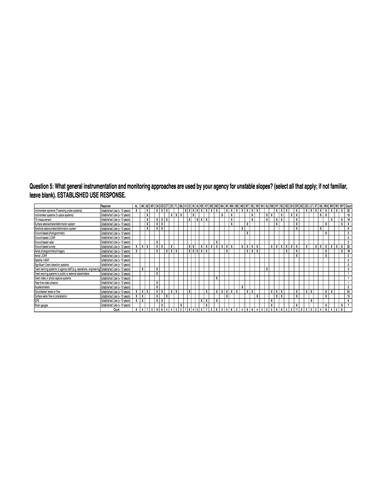
Question 5: What general instrumentation and monitoring approaches are used by your agency for unstable slopes? (select all that apply; if not familiar, leave blank). ESTABLISHED USE RESPONSE. Response AL AK AZ AR CA CO CT DE FL GA HI ID IN IA KS KY ME MD MA MI MN MS MO MT NE NV NH NJ NM NY NC ND OH OR SC SD UT VT VA WA WV WI WY Count Inclinometer systems (Traversing probe systems) Established Use (> 10 years) X X X X X X X X X X X X X X X X X X X X X X X X X X X X X X X X 32 Inclinometer systems (In-place systems) Established Use (> 10 years) XX X X XX X X X X X X XX X 15 Tilt measurement Established Use (> 10 years) X X X X X X X X X X X X X X X X 16 Surface extensometer/deformation system Established Use (> 10 years) X X X X XXXX X 9 Borehole extensometer/deformation system Established Use (> 10 years) X X X 6XXX Ground-based photogrammetry Established Use (> 10 years) X X 2 Ground-based LiDAR Established Use (> 10 years) 0 Ground-based radar Established Use (> 10 years) XX 2 Ground-based survey Established Use (> 10 years) X X X X X X X X X X X X X X X X X X X X X X X X X X X X X X X X 32 Aerial photogrammetry/imagery Established Use (> 10 years) X X X X X X X X X X X X X X X X X X 18 Aerial LiDAR Established Use (> 10 years) 2XX Satellite InSAR Established Use (> 10 years) 0 Significant Event detection systems Established Use (> 10 years) 0 Event warning systems to agency staff (e.g. operations, engineering)Established Use (> 10 years) X X X 3 Event warning systems to public or external stakeholders Established Use (> 10 years) X 1 Event video or photo capture systems Established Use (> 10 years) X 1 Real-time video streams Established Use (> 10 years) X 1 Accelerometers Established Use (> 10 years) X X 2 Groundwater levels or flow Established Use (> 10 years) X X X X X X X X X X X X X X X X X X X X X X X X 24 Surface water flow or precipitation Established Use (> 10 years) X X X X X X X X X X 10 GPS Established Use (> 10 years) X X X X X X X X X 9 Strain gauges Established Use (> 10 years) XXX XXXX 7 Count 6 5 7 0 14 8 4 4 3 2 1 5 4 3 5 7 2 6 3 5 6 2 4 6 6 4 0 3 5 6 6 3 2 11 0 3 3 2 4 10 4 2 6
Question 6: Which of the following instrumentation and monitoring data collection, viewing and communication methods are used by your agency for unstable slopes? (select all that apply; if not familiar, leave blank). NOT USED RESPONSE. Question 6: Which of the following instrumentation and monitoring data collection, viewing and communication methods are used by your agency for unstable slopes? (select all that apply; if not familiar, leave blank). NEW USE RESPONSE. Question 6: Which of the following instrumentation and monitoring data collection, viewing and communication methods are used by your agency for unstable slopes? (select all that apply; if not familiar, leave blank). ESTABLISHED USE RESPONSE. Response AL AK AZ AR CA CO CT DE FL GA HI ID IN IA KS KY ME MD MA MI MN MS MO MT NE NV NH NJ NM NY NC ND OH OR SC SD UT VT VA WA WV WI WY Count XXXdesU toNgnidrocer desab-repap dna gnirotinom launaM X X Manual monitoring and tablet or other electronic recording Not Used X X X X Onsite real-time data acquisition for 1 to a few instruments of XXXXXXXXXXXXdesU toN epyt emas eht Onsite real-time data acquisition for several different types i XXXXXXXXXXXXXXXXXXXXXdesU toN stnemurtsn Transmission of data offsite via wireless (radio, cellular, etc XXXXXXXXXXXXXXXXdesU toN yrtemelet ). Onsite data analysis for decision support Not Used X X X X X X X X X X X X X X X X X X X X X Remote real-time viewing of data Not Used X X X X X X X X X X X X X X X X Remote viewing of recorded data Not Used X X X X X X X X X X X X X X X Web-based access or presentation of data to agency staff Not Used X X X X X X X X X X X X X X X Web-based presentation of data to stakeholders outside of agency Not Used X X X X X X X X X X X X X X X X X X X X X X X X X Count 7 4 8 3 1 1 8 0 0 0 0 6 4 9 8 1 9 2 0 1 1 0 0 2 8 7 8 0 3 3 2 3 0 6 0 9 0 2 6 0 8 3 7 Response AL AK AZ AR CA CO CT DE FL GA HI ID IN IA KS KY ME MD MA MI MN MS MO MT NE NV NH NJ NM NY NC ND OH OR SC SD UT VT VA WA WV WI WY Count y 01 nihtiw( esU weNgnidrocer desab-repap dna gnirotinom launaM X)srae X Manual monitoring and tablet or other electronic recording New Use (within 10 years) X X X X X X X X X X X X X X X X X Onsite real-time data acquisition for 1 to a few instruments of XXXXXXXXXXXXXXXX)sraey 01 nihtiw( esU weN epyt emas eht Onsite real-time data acquisition for several different types i XXXXXXXXXX)sraey 01 nihtiw( esU weN stnemurtsn Transmission of data offsite via wireless (radio, cellular, etc XXXXXXXXXXXXXXX)sraey 01 nihtiw( esU weN yrtemelet ). Onsite data analysis for decision support New Use (within 10 years) X X X X X X X X X X Remote real-time viewing of data New Use (within 10 years) X X X X X X X X X X X X X X X X Remote viewing of recorded data New Use (within 10 years) X X X X X X X X X X X X X X X Web-based access or presentation of data to agency staff New Use (within 10 years) X X X X X X X X X X X X X X X X Web-based presentation of data to stakeholders outside of agenc XXXXX)sraey 01 nihtiw( esU weNy X Count 0 4 0 6 6 8 1 10 0 1 3 1 4 0 0 6 0 7 0 7 1 1 0 6 0 2 0 0 6 5 6 6 0 1 0 0 10 7 3 1 0 4 0 Response AL AK AZ AR CA CO CT DE FL GA HI ID IN IA KS KY ME MD MA MI MN MS MO MT NE NV NH NJ NM NY NC ND OH OR SC SD UT VT VA WA WV WI WY Count Manual monitoring and paper-based recording Established Use (> 10 years) X X X X X X X X X X X X X X X X X X X X X X X X X X X X X X X X X Manual monitoring and tablet or other electronic recording Established Use (> 10 years) X X X X X X X X X X X X X X X X X X X X Onsite real-time data acquisition for 1 to a few instruments of XXXXXXXXXXX)sraey 01 >( esU dehsilbatsE epyt emas eht Onsite real-time data acquisition for several different types i XX)sraey 01 >( esU dehsilbatsE stnemurtsn X X Transmission of data offsite via wireless (radio, cellular, etc.) telemetry Established Use (> 10 years) X XX X Onsite data analysis for decision support Established Use (> 10 years) X X X X X Remote real-time viewing of data Established Use (> 10 years) X X Remote viewing of recorded data Established Use (> 10 years) XX X Web-based access or presentation of data to agency staff Established Use (> 10 years) X X Web-based presentation of data to stakeholders outside of agenc X)sraey 01 >( esU dehsilbatsEy X Count 3 2 2 1 3 1 1 0 2 0 1 3 2 1 2 3 1 1 2 2 8 2 2 1 2 2 2 3 1 2 2 1 2 3 0 1 2 1 1 9 2 1 3 5 4 12 21 16 21 16 15 15 25 2 17 16 10 15 10 16 15 16 6 33 20 11 4 4 5 2 3 2 2
Question 7: Has your agency developed or deployed an innovative instrumentation or monitoring technology within the last 10 years for an agency special case or specific unstable slope problem? Question 8: How many unstable slope sites are currently in a regular or planned instrumentation and monitoring program for your agency? Question 9: In your agency, what describes the frequency that data obtained using instrumentation and monitoring technology are evaluated or interpreted for use in reporting or response actions on unstable slopes? (check all that apply) Question 10: How are data from the instrumentation and monitoring of unstable slopes used by your agency? (check all that apply) AL AK AZ AR CA CO CT DE FL GA HI ID IN IA KS KY ME MD MA MI MN MS MO MT NE NV NH NJ NM NY NC ND OH OR SC SD UT VT VA WA WV WI WY Count Yes X X X X X X X X X X X X X X X X X X X X X X 22 No X X X X X X X X X X X X X X X X X X X X X 21 AL AK AZ AR CA CO CT DE FL GA HI ID IN IA KS KY ME MD MA MI MN MS MO MT NE NV NH NJ NM NY NC ND OH OR SC SD UT VT VA WA WV WI WY Count 1 to 5 X X X X X X X X X X X X X X X 15 5 to 1 XXX0 XX X 6 10 to 25 X X X X X X X X X X 10 25 to 50 X 4XXX Greater than 50 X X X X 4 Count 1 0 1 1 1 1 1 1 1 0 1 1 1 0 1 1 1 1 1 1 1 1 1 1 1 1 1 1 1 1 1 1 1 1 0 1 1 1 1 1 1 1 1 AL AK AZ AR CA CO CT DE FL GA HI ID IN IA KS KY ME MD MA MI MN MS MO MT NE NV NH NJ NM NY NC ND OH OR SC SD UT VT VA WA WV WI WY Count Daily X X X X X X X X X X X X 12 Weekly XXXXXX X X X X X X XX X X 16 Approximately monthly X X X X X X X X X X X X X X X X X X X X X 21 A few times per year X X X X X X X X X X X X X X X X X X X X X X 22 Once every 1 to 2 years X X X X X X X X X X X X 12 Rarely X X X X X X 6 Count 3 1 1 1 5 1 1 1 3 1 1 1 2 1 1 1 1 1 1 1 3 3 3 3 4 1 2 1 1 4 4 3 6 1 1 2 1 3 4 4 1 3 2 AL AK AZ AR CA CO CT DE FL GA HI ID IN IA KS KY ME MD MA MI MN MS MO MT NE NV NH NJ NM NY NC ND OH OR SC SD UT VT VA WA WV WI WY Count Emergency or warning 71XXXXXXXXXXXXXXXXX Establish extent and rate of movement for use in design of stabilization solution X X X X X X X X X X X X X X X X X X X X X X X X X X X X X X X X X X X X X 37 Improve reliability for site specific hazard mitigation design decisions 42XXXXXXXXXXXXXXXXXXXXXXXX Tracking of movement or activity to trigger additional treatment actions X X X X X X X X X X X X X X X X X X X X X X X X X X X X X X X X X X X X X X X 39 Research activities 31XXXXXXXXXXXXX Public or other external stakeholder communications X X X 3 To establish if movement is within tolerance for construction activities 42XXXXXXXXXXXXXXXXXXXXXXXX Supporting maintenance and operational decisions X X X X X X X X X X X X X X X X X X X X X X X X X X X X 28 Other (please specify) 0 Count 6 5 5 3 7 8 4 2 2 4 4 4 4 2 3 7 5 6 1 7 5 4 3 4 7 5 3 3 4 4 5 4 2 6 0 4 5 4 7 6 4 3 4
Question 11: How is funding for instrumentation and monitoring of unstable slopes obtained? (check all that apply) Question 12: What is the estimated approximate range in annual funds committed to instrumentation and monitoring of unstable slopes in the agency? Question 13: What approximate percentages of instrumentation and monitoring services are performed in-house? (select estimated percentage range; services that are not completed in-house would be performed by vendors, contractors, consultants, etc.) AL AK AZ AR CA CO CT DE FL GA HI ID IN IA KS KY ME MD MA MI MN MS MO MT NE NV NH NJ NM NY NC ND OH OR SC SD UT VT VA WA WV WI WY Count From discretionary funds in agency geotechnical budget 51XXXXXXXXXXXXXXX Agency pre-engineering or engineering design project fund sources X X X X X X X X X X X X X X X X X X X X X X X X X X X X X X 30 From dedicated funds in agency geotechnical budget X X X X X X X X 8 Emergency/contingency funds within agency X X X X X X X X X X X X X X X X X X X X X X 22 Operations or maintenance budgets X X X X X X X X X X X X X X X X X X X X X X X 23 Emergency/contingency funds external to the agency X X X X X X X X X X X 11 Construction project engineering funds X X X X X X X X X X X X X X X X X X X X X X X X X X 26 Other (please specify) X X X 3 Count 5 3 2 1 5 4 3 1 4 1 2 4 3 1 3 5 3 4 2 5 5 7 4 2 3 2 4 2 2 2 4 3 3 3 0 3 4 3 5 6 4 3 3 AL AK AZ AR CA CO CT DE FL GA HI ID IN IA KS KY ME MD MA MI MN MS MO MT NE NV NH NJ NM NY NC ND OH OR SC SD UT VT VA WA WV WI WY Count 01XXXXXXXXXX000,01$ < XXXXXXX000,05$ ot 000,01$ X X X X X X X X X 16 XXXXXXX000,052$ ot 000,05$ 7 X000,052$ > X 2 Count 1 1 1 1 1 1 1 1 1 0 0 0 0 1 1 1 1 1 1 1 1 1 1 1 1 1 1 1 1 1 1 1 0 1 0 1 1 1 0 1 0 1 1 AL AK AZ AR CA CO CT DE FL GA HI ID IN IA KS KY ME MD MA MI MN MS MO MT NE NV NH NJ NM NY NC ND OH OR SC SD UT VT VA WA WV WI WY Count Purchase of equipment and material from suppliers - 0 to 25 % 11XXXXXXXXXXX Purchase of equipment and material from suppliers - 25% to 50% 6XXXXXX Purchase of equipment and material from suppliers - 50% to 75% 01XXXXXXXXXX Purchase of equipment and material from suppliers - 75% to 100% 41XXXXXXXXXXXXXX Installation of instrumentation and monitoring equipment - 0 to 25 % 01XXXXXXXXXX Installation of instrumentation and monitoring equipment - 25% to 50% XX 4XX Installation of instrumentation and monitoring equipment - 50% to 75% X X X X X X X X X X X 11 Installation of instrumentation and monitoring equipment - 75% to 100% X X X X X X X X X X X X X X X X 16 Remote Sensing - 0 to 25 % X X X X X X X X X X X X X X X X X X X X X X X X X 25 Remote Sensing - 25% to 50% X X 2 Remote Sensing - 50% to 75% X X X X X X 6 Remote Sensing - 75% to 100% XX X X 4 Installation of warning systems - 0 to 25 % X X X X X X X X X X X X X X X X X X X X X X X X X X X X 28 Installation of warning systems - 25% to 50% X 1 Installation of warning systems - 50% to 75% X 1 Installation of warning systems - 75% to 100% XX X X X 5 On-going maintenance and repair of in-situ installed instrumentation - 0 to 25 % XX X X X X X XX X X 11 On-going maintenance and repair of in-situ installed instrumentation - 25% to 50% XX 3X On-going maintenance and repair of in-situ installed instrumentation - 50% to 75% X X X X 4 On-going maintenance and repair of in-situ installed instrumentation - 75% to 100% X X X X X X X X X X X X X X X X X X X 19 Data management - 0 to 25 % X X X X X X X X 8 Data management - 25% to 50% X X X X 4 Data management - 50% to 75% X X X X X X 6 Data management - 75% to 100% X X X X X X X X X X X X X X X X X X X X X X X 23 Count 6 6 6 3 6 6 6 6 3 0 6 6 6 6 6 6 6 6 6 6 6 6 3 6 6 4 6 6 6 6 6 6 6 6 0 6 6 6 6 6 6 5 4
Question 14: How are unstable slope instrumentation and monitoring data managed? (check all that apply) Question 15: Has your agency developed internally, or procured contract services for development of, a web-based data acquisition and viewing system for instrumentation and monitoring data from unstable slope sites? Question 16: What visualization and communication methods are used by your agency for instrumentation and monitoring data from unstable slopes? (check all that apply) Question 17: Which of the following would enable an increased use of instrumentation and monitoring for unstable slopes in your agency? AL AK AZ AR CA CO CT DE FL GA HI ID IN IA KS KY ME MD MA MI MN MS MO MT NE NV NH NJ NM NY NC ND OH OR SC SD UT VT VA WA WV WI WY Count By site and the associated site-specific technologies X X X X X X X X X X X X X X X X X X X X X X X X X X X X X X X X X X X X X X X X 40 A program-wide system that incorporates numerous or all sites in one database or system X X X X X X X X 8 Unsure X 1 Other (please specify) X X X X 4 Count 2 3 1 1 1 2 1 2 1 1 1 1 2 1 1 1 1 1 1 1 2 1 1 1 1 1 1 1 3 1 2 1 1 1 0 1 1 1 1 2 1 1 1 AL AK AZ AR CA CO CT DE FL GA HI ID IN IA KS KY ME MD MA MI MN MS MO MT NE NV NH NJ NM NY NC ND OH OR SC SD UT VT VA WA WV WI WY Count 7XXXXXXXsecivres lanretxe derucorp â seY Yes â internally developed X 1 XXXsecivres lanretxe dna lanretni fo noitanibmoc a â seY 4X 92XXXXXXXXXXXXXXXXXXXXXXXXXXXXXoN 0111111101111111111111111111111111111111111tnuoC AL AK AZ AR CA CO CT DE FL GA HI ID IN IA KS KY ME MD MA MI MN MS MO MT NE NV NH NJ NM NY NC ND OH OR SC SD UT VT VA WA WV WI WY Count Site specific reports prepared with conventional word processing and spreadsheet software X X X X X X X X X X X X X X X X X X X X X X X X X X X X X X X X X X X X X X 38 Instrumentation vendor developed software and/or web-based syst 62XXXXXXXXXXXXXXXXXXXXXXXXXXsme Custom agency developed/programed software or web-based systems 6XXXXXX XXXsmetsys ytilaer lautriv ro erawtfos gniweiv egami D3 4X Third party (but not an instrumentation vendor) commercial software as a service platform X X X 3 Other (please specify) X 1 Count 2 1 2 1 2 5 1 3 1 1 1 1 3 1 2 4 2 5 1 2 2 2 1 2 2 1 1 1 2 1 1 1 2 2 0 2 3 2 2 2 2 2 1 AL AK AZ AR CA CO CT DE FL GA HI ID IN IA KS KY ME MD MA MI MN MS MO MT NE NV NH NJ NM NY NC ND OH OR SC SD UT VT VA WA WV WI WY Count Training X X X X X X X X X X X X X X X X X X X X X X X X X X 26 Additional Funds X X X X X X X X X X X X X X X X X X X X X X X X X X X X X X X X 32 XXXserudecorp dna ecnadiug lamrof rehto ro OTHSAA ,AWHF ,ycnegA 71XXXXXXXXXXXXXX 62XXXXXXXXXXXXXXXXXXXXXXXXXXsecruoser ffats lacinhcetoeg ycnega lanoitiddA External contractor availability with specialty experience in i 9XXXXXXXXXgnirotinom dna noitatnemurtsn XXXXXXXXXmargorp lacinhcetoeg fo edistuo secruoser ffats ycnegA 9 XXXXXXXesu desaercni rof deen a eviecrep tânod â yrassecen enoN X 8 Other (please specify) 5XXXXX Count 5 5 1 3 3 6 1 3 1 1 6 3 5 1 2 5 1 3 2 4 6 4 4 1 2 1 4 2 2 4 3 4 5 2 4 1 3 3 5 4 3 3 1
Abbreviations and acronyms used without definitions in TRB publications: A4A Airlines for America AAAE American Association of Airport Executives AASHO American Association of State Highway Officials AASHTO American Association of State Highway and Transportation Officials ACIâNA Airports Council InternationalâNorth America ACRP Airport Cooperative Research Program ADA Americans with Disabilities Act APTA American Public Transportation Association ASCE American Society of Civil Engineers ASME American Society of Mechanical Engineers ASTM American Society for Testing and Materials ATA American Trucking Associations CTAA Community Transportation Association of America CTBSSP Commercial Truck and Bus Safety Synthesis Program DHS Department of Homeland Security DOE Department of Energy EPA Environmental Protection Agency FAA Federal Aviation Administration FAST Fixing Americaâs Surface Transportation Act (2015) FHWA Federal Highway Administration FMCSA Federal Motor Carrier Safety Administration FRA Federal Railroad Administration FTA Federal Transit Administration HMCRP Hazardous Materials Cooperative Research Program IEEE Institute of Electrical and Electronics Engineers ISTEA Intermodal Surface Transportation Efficiency Act of 1991 ITE Institute of Transportation Engineers MAP-21 Moving Ahead for Progress in the 21st Century Act (2012) NASA National Aeronautics and Space Administration NASAO National Association of State Aviation Officials NCFRP National Cooperative Freight Research Program NCHRP National Cooperative Highway Research Program NHTSA National Highway Traffic Safety Administration NTSB National Transportation Safety Board PHMSA Pipeline and Hazardous Materials Safety Administration RITA Research and Innovative Technology Administration SAE Society of Automotive Engineers SAFETEA-LU Safe, Accountable, Flexible, Efficient Transportation Equity Act: A Legacy for Users (2005) TCRP Transit Cooperative Research Program TDC Transit Development Corporation TEA-21 Transportation Equity Act for the 21st Century (1998) TRB Transportation Research Board TSA Transportation Security Administration U.S. DOT United States Department of Transportation
A dvances in U nstable Slope Instrum entation and M onitoring N CH RP Synthesis 554 TRB TRA N SPO RTATIO N RESEA RCH BO A RD 500 Fifth Street, N W W ashington, D C 20001 A D D RESS SERV ICE REQ U ESTED N O N -PR O FIT O R G . U .S. PO STA G E PA ID C O LU M B IA , M D PER M IT N O . 88 ISBN 978-0-309-48172-4 9 7 8 0 3 0 9 4 8 1 7 2 4 9 0 0 0 0
