


Below is the uncorrected machine-read text of this chapter, intended to provide our own search engines and external engines with highly rich, chapter-representative searchable text of each book. Because it is UNCORRECTED material, please consider the following text as a useful but insufficient proxy for the authoritative book pages.
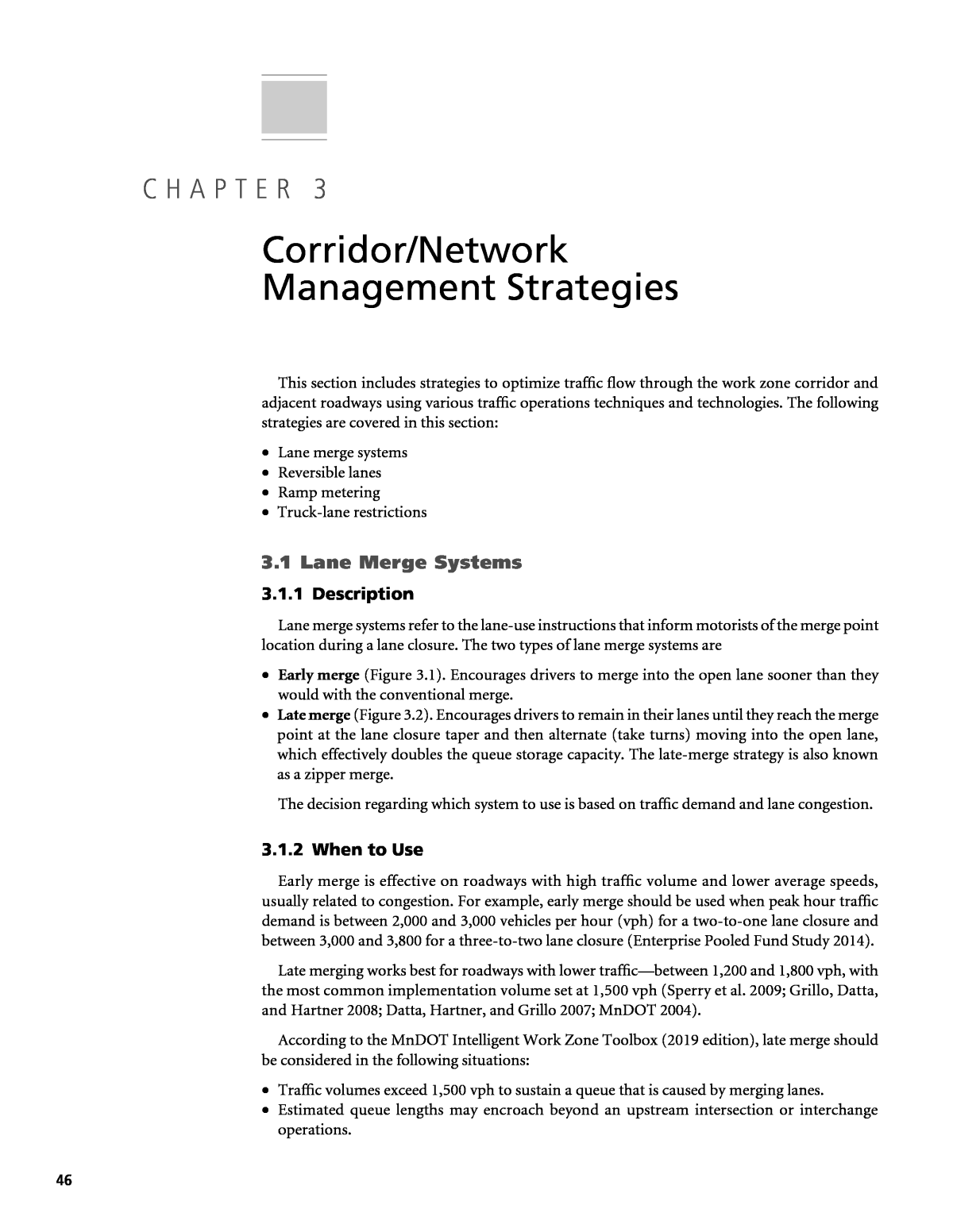
46 This section includes strategies to optimize traffic flow through the work zone corridor and adjacent roadways using various traffic operations techniques and technologies. The following strategies are covered in this section: ⢠Lane merge systems ⢠Reversible lanes ⢠Ramp metering ⢠Truck-lane restrictions 3.1 Lane Merge Systems 3.1.1 Description Lane merge systems refer to the lane-use instructions that inform motorists of the merge point location during a lane closure. The two types of lane merge systems are ⢠Early merge (Figure 3.1). Encourages drivers to merge into the open lane sooner than they would with the conventional merge. ⢠Late merge (Figure 3.2). Encourages drivers to remain in their lanes until they reach the merge point at the lane closure taper and then alternate (take turns) moving into the open lane, which effectively doubles the queue storage capacity. The late-merge strategy is also known as a zipper merge. The decision regarding which system to use is based on traffic demand and lane congestion. 3.1.2 When to Use Early merge is effective on roadways with high traffic volume and lower average speeds, usually related to congestion. For example, early merge should be used when peak hour traffic demand is between 2,000 and 3,000 vehicles per hour (vph) for a two-to-one lane closure and between 3,000 and 3,800 for a three-to-two lane closure (Enterprise Pooled Fund Study 2014). Late merging works best for roadways with lower trafficâbetween 1,200 and 1,800 vph, with the most common implementation volume set at 1,500 vph (Sperry et al. 2009; Grillo, Datta, and Hartner 2008; Datta, Hartner, and Grillo 2007; MnDOT 2004). According to the MnDOT Intelligent Work Zone Toolbox (2019 edition), late merge should be considered in the following situations: ⢠Traffic volumes exceed 1,500 vph to sustain a queue that is caused by merging lanes. ⢠Estimated queue lengths may encroach beyond an upstream intersection or interchange operations. C H A P T E R 3 Corridor/Network Management Strategies
Corridor/Network Management Strategies 47 ⢠Speeds and lane occupancy volumes are anticipated to vary unpredictably and cause the motorist to have trouble identifying the best lane-use practice, such as using both lanes versus moving into the continuous thru-lane. Figure 3.3 shows a flowchart developed by ATSSA (2012) to help DOTs decide when to use static merging strategies (early or late) or a dynamic combination of early and late strategies. Figure 3.1. Illustration of early-merge concept (Credit: FHWA). Figure 3.2. Illustration of late-merge concept (Credit: FHWA). Figure 3.3. Lane-merging decision-making flowchart (Credit: ATSSA).
48 Strategies for Work Zone Transportation Management Plans 3.1.3 Benefits The use of an early-merge system provides the following benefits: ⢠Reduces aggressive driving and unsafe merge maneuvers. ⢠Provides significant advanced warning to allow drivers adequate distance to merge. ⢠Gives positive instructions on lane usage. ⢠Improves vehicle throughput slightly. The use of a late-merge system provides the following benefits: ⢠Maximizes available storage upstream of work zone for reducing total queue length. ⢠Increases overall vehicle throughput. ⢠Reduces the differential speed between lanes by using both traffic lanes, because both lanes travel at approximately the same speed. ⢠Reduces aggressive driving and possibly reduces crashes. 3.1.4 Expected Effectiveness Compared to the early merge, the late-merge strategy has been studied more extensively with the following results: ⢠Reduction of 3- to 24-minute delays (FHWA 2015) ⢠38.5 percent reduction in average travel time for every 10,000 ft of travel per vehicle, 61.3 percent increase in average speed, 22 percent increase in capacity, and 16 percent reduction in percentage of vehicles merging at taper (Datta, Hartner, and Grillo 2007) ⢠29.8 percent increase in work zone capacity (Qin, Noyce, and Chen 2006) ⢠17.8 percent increase in vphpl and a 15 percent reduction in maximum queue length (Kang et al. 2006) ⢠30 percent to 40 percent increase in percentage of drivers using the discontinuous lane near the taper point during peak congestion times (MnDOT 2004) ⢠35 percent reduction in queue length (MnDOT 2003) 3.1.5 Crash Modification Factor No CMF is available for this strategy. 3.1.6 Implementation Considerations Agencies can implement early- and late-merging methods in a static (passive) or dynamic (active) manner. Static merging systems use static signs to instruct motorists on where to merge. The static signs may have flashing lights that are activated at certain times of the day. Figure 3.4 shows an example of static late merge. A dynamic lane-merging system (DLMS) is a type of SWZ system that collects real-time traffic information (e.g., speeds, volume, occupancy) and switches between early and late merge depending on traffic conditions. An example of dynamic late merge is shown in Figure 3.5. Aspects to consider before DLMS deployment include sign spacing, PCMS messaging, and public outreach. Sign spacing needs to be modified according to the geometry of the road, the expected queue length, and the average expected speed of the vehicles. Additionally, driversâ familiarity with the roadway and whether entrance or exit ramps are near the merging area needs to be considered.
Corridor/Network Management Strategies 49 Figure 3.4. Static (passive) zipper merge layout (Credit: MnDOT).
50 Strategies for Work Zone Transportation Management Plans Figure 3.5. Dynamic late-merge (i.e., zipper merge) system layout (Credit: MnDOT).
Corridor/Network Management Strategies 51 It is pertinent to ensure that the PCMS is displaying reasonable messages. The PCMS should be located in advance of the lane closure as determined by the engineer based on estimated queue lengths and geometry. An example PCMS display for late merge follows: ⢠PCMS located beyond estimated maximum queue length: STOPPED TRAFFIC AHEAD (Phase 1), USE BOTH LANES (Phase 2). ⢠Intermediate PCMS located beyond estimated queue length at the time when DLMS activation will occur: MERGE AHEAD (Phase 1), USE BOTH LANES (Phase 2). ⢠PCMS located at point of merge shall display: MERGE HERE (Phase 1), TAKE TURNS (Phase 2). Accomplishing a successful, safe DLMS will require a public outreach campaign to help motorists understand how to navigate safely through the merge system. 3.1.7 Design Features and Requirements A DLMS typically involves portable traffic sensors that detect real-time traffic characteristics (speeds, occupancy, etc.), a series of PCMSs to display messages to motorists upstream of the work zone, and an automated traffic system that stores the data and uses algorithms to turn the system on and off. When speeds drop below the default speed threshold, a series of PCMSs are activated, encouraging the motorists to stay in their lanes and take turns to merge at a designated location, thus improving traffic flow, reducing the queue, and improving overall safety. Once the congestion dissipates, the PCMSs are deactivated and motorists follow the early-merge process. 3.1.8 State of the Practice A DLMS is one of the technology applications promoted by the FHWAâs SWZ, during Round 3 of the Every Day Counts (EDC) initiative.9 The National Work Zone Safety Infor- mation Clearinghouse website (https://www.workzonesafety.org/swz/) provides resources including bid specifications, deployment plans, and case studies. Examples of DLMS deploy- ments follow. 3.1.8.1 Minnesota MnDOT first introduced the zipper merge in the early 2000s and has deployed it on several projects. The department also created video tutorials and conducted extensive public service announcements on radio and TV stations, news websites, and highway billboards. MnDOT uses both passive (static signs) and active (intelligent work zone) systems to implement the zipper merge and developed standard layouts (Appendix D1). 3.1.8.2 Kansas KSDOT implemented a dynamic late lane merge system (i.e., zipper merge) in association with a bridge deck repair project in Overland Park from July 7 to November 1, 2016. Appendix D2 shows the layout of the system. System performance was evaluated using the duration of the traffic queues during any given day for the first 12 weeks of the project. During the first 3 weeks of the project, a vehicle queue extended to the furthest sensor approxi- mately 4.5 mi away from the merge point for only 68 minutes. For weeks 4â6, that sensor saw 9 Information on the FHWA promotion of SWZs is found on the Every Day Counts Initiative: Smarter Work Zones, Technology Applications: Dynamic Lane Merge web page: https://www.workzonesafety.org/swz/swztechnology-application/ types-of-applications/dynamic-lane-merge/.
52 Strategies for Work Zone Transportation Management Plans queues for only 35 minutes, and for weeks 7â9, that location saw queues for 76 minutes. Data for weeks 10â12 was skewed because of another work zone operation that involved a lane closure. To help motorists navigate the system, KSDOT conducted an extensive education effort that included news releases, interviews, public meetings, a project website, and a video (https://www. youtube.com/watch?v=8wgSjstvsPc). The video was used to educate the driving public about the dynamic late merge and address several of the major criticisms about late merging. After the zipper merge was started the week of July 5, 2016, several local TV stations did stories that featured elements of the video. Ultimately, the video was viewed almost 200,000 times between YouTube and Facebook. 3.1.8.3 North Carolina NCDOT implemented the dynamic late merge (zipper merge) on an I-85 work zone in Vance and Warren Counties just south of the Virginia state line. NCDOT implemented the zipper merge during the first week of October 2016. Using the zipper merge setup decreased travel time by 1 minute, which equates to an 11-mph increase in mean speed. The greatest improvement related to implementing the zipper merge was in safety; after implementing zipper merge, fewer vehicles entered the shoulder to merge. 3.1.8.4 Massachusetts As part of its I-91 Springfield Viaduct reconstruction project, the Massachusetts DOT (MassDOT) implemented a zipper merge system to improve traffic flow and increase safety where the lanes on I-91 south dropped from two to one. The DLMS was in effect from October 2016 to March 2018. At the time this guidebook was written, MassDOT is still eval- uating the effects of the DLMS. 3.1.8.5 Wisconsin WisDOT implemented its first dynamic late-merge system as part of the Zoo Interchange project in 2016. Implementing the zipper merge was preceded by an extensive public campaign that included developing an instructional fact sheet (Appendix D3) and an instructional video (https://www.youtube.com/watch?v=FhKZKmS2Ag4). 3.1.8.6 Colorado The CDOT has developed a standard layout for zipper merge (Appendix D4) and a public relations late-merge video (https://www.codot.gov/library/traffic/work-zone-safety-and-work- zone-traffic-operations/work-zone-traffic-operations-strategies/travel-demand-management/ late-merge-work-zone-traffic-control-strategy/CDOT-Late-Merge-newLogo.mp4). 3.1.8.7 Michigan MDOT has deployed zipper merge on several projects: ⢠US-2 bridge over the Escanaba River, Delta County (OctoberâNovember 2018) ⢠I-96 concrete joint repairs, Lowell (MayâSeptember 2014) ⢠I-196 bridge work near Grand Rapids (AprilâJuly 2013) 3.1.9 Cost The cost to deploy an SWZ such as the dynamic merge system depends on the project duration and the number of devices used (e.g., message boards, traffic sensors, speed trailers, cameras).
Corridor/Network Management Strategies 53 In general, the rental cost is the same for a PCMS or a traffic sensor or cameraâapproximately $1,000 per week. For longer-duration projects, the rental costs can be substantially lower. MnDOT reported the cost estimate, based on 2018 MnDOT rental prices, for an active zipper merge project using two PCMS and six sensors at $7,000 per week, or $13,000 per month, or $58,000 per 6 months. 3.1.10 Resources and References American Traffic Safety Services Association (ATSSA). Guidance for the Use of Dynamic Lane Merging Strategies, U.S. DOT, Washington, D.C., 2012. Beacher, A. G., M. D. Fontaine, and N. J. Garber. Evaluation of the Late Merge Work Zone Traffic, VTRC 05-R6, Virginia Transportation Research Council, Charlottesville, VA, 2004. Beacher, A. G., M. D. Fontaine, and N. J. Garber. Guidelines for Using Late Merge Traffic Control in Work Zones: Results of a Simulation-Based Study. Transportation Research Record: Journal of the Transportation Research Board, No. 1911, 2005, pp. 42â50. Datta, T. K., C. Hartner, and L. Grillo. Evaluation of the Dynamic Late Lane Merge System at Freeway Construc- tion Work Zones, Wayne State University. Research Report RC-1500. September 2007. Enterprise Pooled Fund Study. Dynamic Merge Systems in Work Zones: Summary of Uses and Benefits, June 2014. FHWA Every Day Counts (EDC) Initiative: Smarter Work Zones, Technology Applications: Dynamic Lane Merge web page. https://www.workzonesafety.org/swz/swztechnology-application/types-of-applications/ dynamic-lane-merge/. FHWA. Smart Work Zone Webinar Series. Webinar #6: SWZ Case Study: Variable Speed Limit and Dynamic Lane Merge, November 12, 2015. https://www.workzonesafety.org/swz/webinars/. Grillo, L. F., T. K. Datta, and C. Hartner. Dynamic Late Lane Merge System at Freeway Construction Work Zones. Transportation Research Record: Journal of the Transportation Research Board, No. 2055, Vol. 1, 2008, pp. 3â10. https://doi.org/10.3141/2055-01. Ishak, S., Y. Qi, and P. Rayaprolu. âSafety Evaluation of Joint and Conventional Lane Merge Configurations for Freeway Work Zones,â Traffic Injury Prevention, 13(2), pp. 199â208. Kang, K. P., G. L. Chang, and J. Paracha. Dynamic Late Merge Control at Highway Work Zones: Evaluations, Observations, and Suggestions. Transportation Research Record: Journal of the Transportation Research Board, No. 1948, 2006, pp. 86â95. McCoy, P. T., and G. Pesti. Dynamic Late Merge-Control Concept for Work Zones on Rural Interstate Highways. Transportation Research Record: Journal of the Transportation Research Board, No. 1745, 2001, pp. 20â26. MnDOT. Dynamic Late Merge System Evaluation, Initial Deployment on US-10. Minnesota Department of Transportation, 2003. MnDOT. Evaluation of 2004 Dynamic Late Merge System, Minnesota Department of Transportation, December 2004. MnDOT. Intelligent Work Zone Toolbox, 2019 edition, Minnesota Department of Transportation. Qin, X., D. A. Noyce, and Y. Chen. Evaluation of Dynamic Late Merge System in Highway Work Zones. Traffic Operations and Safety, (TOPS) Laboratory, Wisconsin Department of Transportation, July 2006. Radwan, E., R. Harb, and S. Ramasamy. Evaluation of Safety and Operational Effectiveness of Dynamic Lane Merge System in Florida, 2009. Sperry, R., T. McDonald, S. Nambisan, and R. Pettit. Effectiveness of Dynamic Messaging on Driver Behavior for Late Merge Lane Road Closures, CTRE Project 08-327, Iowa Department of Transportation, 2009. Tapan D., K. Schattler, P. Kar, and A Guha. Development and Evaluation of an Advanced Dynamic Lane Merge Traffic Control System for 3 to 2 Lane Transition Areas in Work Zones, Wayne State University. Research Report RC-1451, January 2004. Tarko, A., and S. Venugopal. Safety and Capacity Evaluation of the Indiana Lane Merge System, Joint Transportation Research Program, Purdue University. HWA/IN/JTRP-2000/19. February 2001. Vaughan, C., C. Cunningham, S. Warchol, D. Findley, C. Carnes, S. Sallade, G. Oyler, D. Coble, and B. Kearns. The Effects of Late Lane Merges on Travel Times, North Carolina Department of Transportation (FHWA/ NC/2015-08), 2018. Zaidi, Z., E. Radwan, and R. Harb. Evaluating Variable Speed Limits and Dynamic Lane Merging Systems in Work Zones: A Simulation Study. Orlando, Florida: Hindawi Publishing Corporation, 2012.
54 Strategies for Work Zone Transportation Management Plans 3.2 Reversible Lanes 3.2.1 Description A reversible roadway is one in which the direction of traffic flow in one or more lanes or shoulders is reversed to the opposite direction for some period of time. Its utility is derived by taking advantage of the unused capacity of the minor-flow direction to increase capacity in the major-flow direction, thereby negating the need to construct additional lanes. 3.2.2 When to Use Reversible lanes are particularly useful in work zones with a directional imbalance in excess of 65 percent to 35 percent during weekday peak hours, when the number of lanes is reduced and the cost to provide additional capacity would be high. The cost of ROW limitations may even make the cost of reversible lanes too high to implement. 3.2.3 Benefits The primary benefit of reversible lane operation is reducing congestion during periods of high and unbalanced directional travel demand. Their utility results from using the reduced capacity of the minor-flow direction lanes to increase the directional capacity in the major-flow direction. Another significant benefit is the reduction in construction time, which translates into a lower road-user cost (RUC). 3.2.4 Expected Effectiveness Most reversible lane systems were developed and managed based primarily on experience, professional judgment, and empirical observation. Formal analyses of the effects of work zone reversible lane operations are limited. ⢠A work zone reversible lane system was implemented for 2 months (AugustâOctober 2014) on Autobahn A-3 southeast of Frankfurt, Germany, and analysis identified almost 400,000 vehicle hours saved compared with a permanent lane reduction in one direction (Waleczek et al. 2016). ⢠As part of this project (NCHRP 03-111), the effectiveness of reversible lanes was studied at two work zones in Michigan and at another work zone in Minnesota. The results indicated that implementing the reversible lane operation improved travel time between 5.6 percent and 15 percent. The capacity-reduction factor for reversible lane operation appears to be 0.90 to 1.20 per lane, the latter occurring when the reversible lane operation is within barriers and not affected by ramps and other merging traffic. The NCHRP Project 03-111 final report, which details the findings of the reversible lane field evaluations, is published as NCHRP Web-Only Document 276 and is available on the TRB website. MDOT estimated an RUC savings of $30 million at one test site. ⢠The $29 million I-75 Linwood to Pinconning project in Bay County, Michigan, was originally scheduled in 2012 to take 2 years. Instead, MDOT finished reconstructing 32 lane-miles of I-75 in less than 1 year using reversible lanes. 3.2.5 Crash Modification Factor Table 3.1 shows the CMF for work zone reversible lanes. Chapter 13 of this document provides more information on developing WZCMFs.
Corridor/Network Management Strategies 55 3.2.6 Implementation Considerations The ITE Traffic Engineering Handbook (7th edition) recommends that DOTs examine the following criteria before implementing reversible lanes: ⢠The traffic congestion problem under investigation should be both periodic and predictable. ⢠The ratio of a major-to-minor traffic count should be at least 2:1, and preferably 3:1. ⢠ROW (or the ability to acquire it) to construct additional lanes should be limited. Enforcement and incident management are other considerations to control and manage reversible roadways. Because one primary motivation of reversible lane use is to limit the overall cross section width of a road, shoulders along many segments are often narrow or absent. This situation eliminates the ability to use roadside traffic enforcement vehicles. It also greatly limits the ability of vehicles to make emergency stops and of service vehicles to respond to incidents. 3.2.7 Design Features and Requirements The design criteria used for reversible lanes, such as turning radii, sight distances, taper lengths, lanes widths, and so on, are similar to those for conventional highways and should meet the standards and policies set forth in the 2018 AASHTO Green Book, the 2009 MUTCD, and applicable state-specific documents. Agencies should pay particular attention to the design of the termini transitions, as these areas confuse drivers the most. Agencies should also consider the control of pedestrian movements across reversible lanes. Work zone reversible lane applications are controlled in the following ways: ⢠Lane-use control signals (LUCS) indicate which lanes of a reversible roadway are available (or not available) for use in a particular direction. LUCS are distinguished by placing special signal faces over a certain lane or lanes of the roadway and by their distinctive shapes and symbols. The 2009 MUTCD (Chapter 4M) provides standards and guidance for LUCS use. ⢠Channelizing devices such as drums, tubular markers, cones, and vertical panels can be used to separate the opposing traffic. Given a typical twice-daily peak period application, using conventional channelizing devices is labor and time intensive because the devices must be moved into and out of position at different times of the day. A more-innovative barrier system, and one that is gaining in popularity, is the move- able barrier. Moveable barriers have been used on both a permanent basis for roadways and bridges and a temporary basis within construction zones where unbalanced directional flows occur. Moveable barriers can be repositioned laterally by using a transfer vehicle that travels along the barrier. The appearance and performance of moveable concrete barriers are similar to those of fixed concrete barriers and the ends are protected with crash cushions. The 2009 Crash Type Crash Severity Facility Type Volume Range (AADT) CMF Standard Error All Fatal, serious and minor injury All <100,000 1.029 0.2 NOTE: The CMF was derived from three test sites. CMF = crash modification factor; AADT=annual average daily traffic. While the CMF is reliable for the corridors that were studied, analysts should consider whether the results are transferable to any other specific work zone application. Table 3.1. CMFs for work zone reversible lanes.
56 Strategies for Work Zone Transportation Management Plans MUTCD (Figure 6H-45) shows a typical application using moveable barriers for a temporary reversible lane. A swift gate can also be used in conjunction with the moveable machine barrier. A swift gate is an automated lane closure system used for repetitive lane closures. This system consists of tapered gates that pivot from a stored to a deployed position to channel motorists into the correct traffic configuration. The swift gate can be deployed from a handheld device, saving time and money and reducing worker exposure. ⢠The 2009 MUTCD guidelines for reversible lane pavement markings require that âeach side of reversible lanes shall consist of a normal broken double yellow line to delineate the edge of a lane in which the direction of travel is reversed from time to time, such that each of these markings serves as the center line markings of the roadway during some periodâ (2009 MUTCD, Section 3B.03). ⢠The 2009 MUTCD (Section 2B.26) presents the most current standards for design and place- ment of regulatory signs for reversible roadways. The 2009 MUTCD requires that agencies use all post-mounted signs only as a supplement to overhead signs or LUCS. 3.2.8 State of the Practice The following examples demonstrate how state DOTs have used reversible lanes in work zones. 3.2.8.1 District of Columbia Rehabilitation of the Whitney Young Memorial Bridge (2019, expected completion 2020). The Whitney Young Memorial Bridge (also known as the East Capitol Street Bridge) carries approximately 45,000 vehicles daily over the Anacostia River and Kingman Lake in southeast Washington, D.C., near RFK Stadium. The north structure of the bridge carries three lanes of westbound traffic, plus a pedestrian sidewalk. The south structure of the bridge carries three lanes of eastbound traffic, plus a pedestrian sidewalk. The bridge was originally constructed in 1955, and repairs were needed to the bridge deck, concrete abutments, and steel-girder system. Construction is accomplished by closing one bridge structure at a time. The project will main- tain three lanes of traffic by using a reversible middle lane; this allows for two lanes of inbound traffic during morning peak hour and two lanes of outbound traffic during evening peak hour traffic. Traffic is separated by drums, which are moved before and after each peak traffic period (Figure 3.6). Rehabilitation of the Arlington Memorial Bridge (2018, expected completion 2020). The National Park Service and the FHWA are rehabilitating the Arlington Memorial Bridge, which connects the Lincoln Memorial Circle with the Arlington National Cemetery near Washington, D.C. During construction, the six travel lanes that carry about 55,000 vehicles daily are reduced to three travel lanes. Traffic is being maintained under the reversible lane concept. The three travel lanes consist of one eastbound lane, one westbound lane, and one reversible lane (center lane). The reversible lane is reconfigured daily, except weekends and national legal holidays, to carry eastbound traffic from 5:00 a.m. to 9:30 a.m. and westbound traffic from 2:30 to 7:00 p.m. Traffic in these lanes is controlled by overhead LUCS. Space constraints preclude physical separation between opposing traffic (Figure 3.7). 3.2.8.2 Michigan MDOT has used a moveable barrier wall to create reversible lanes on several work zone projects. ⢠US-131 between 10 Mile and 14 Mile roads near Rockford, Kent County (2018). The project involved reducing the four lanes to three lanes and using a reversible lane to accommodate
Corridor/Network Management Strategies 57 peak hour traffic. The moveable barrier was moved twice daily, which allowed contractors to maintain two open lanes of travel during peak volumes (two lanes southbound in the morning and two lanes northbound in the afternoon). The addition of the moveable barrier allowed construction to be completed within one season as opposed to two seasons, which resulted in cost savings over the original estimate. In addition, separating construction traffic from the traveling public has improved safety. ⢠Reconstruction of I-75 from Dixie Highway to Hess Road, Saginaw County (2015 and 2016). The busy five lanes in each direction of I-75 encounter heavy weekend tourist traffic, so repair work on a 3.8-mi section could easily have brought traffic to a standstill and seriously affected Michiganâs tourism industry. Using traditional contraflows with temporary concrete Figure 3.6. East Capitol Street Bridge reversible lane concept (Credit: DDOT). Figure 3.7. Reversible lane operations on Arlington Memorial Bridge using lane-use control signals (Credit: Dave Dildine/WTOP).
58 Strategies for Work Zone Transportation Management Plans barriers to separate directional traffic would mean restricting traffic to a 3/2 pattern through the duration of the $46 million project. Instead, MDOT used a reversible lane to keep three lanes open in the peak direction at all times while retaining positive barrier protection between opposing traffic lanes. The reversible lane provided three lanes north Wednesday through to Saturday, and three lanes south Sunday through Tuesday (Figure 3.8). Switching from one configuration to the other took about 30 minutes without the need to stop traffic during the switchover. The reversible lanes were in operation during the reconstruction of both the northbound roadbed (MayâJuly 2015) and the southbound roadbed (MayâJuly 2016). After the project finished in September 2016, MDOT estimated using reversible lanes saved $30 million in user delay. ⢠I-75 Linwood to Pinconning project in Bay County (2012). This $29 million project was originally scheduled to take 2 years to complete. Instead, MDOT finished repairing and reconstructing 32 lane-miles of I-75 in less than 1 year. Using reversible lanes was one inno- vation that helped accelerate the construction schedule, which was the key component to the success of this project. All traffic was switched over to one side of the highway, and a wall of moveable barrier was deployed to separate the northbound and southbound traffic. The wall was moved twice each week to keep two lanes open for heavy tourist traffic in one direction (northbound on Fridays and Saturdays, southbound on Sundays). This helped mitigate the potential traffic congestion and allowed the contractor full access to one side of the freeway for better-quality repairs and an accelerated construction schedule. 3.2.8.3 Minnesota I-94 between East 7th Street in Saint Paul and Hwy 120/Century Avenue in Maplewood, Minnesota (2017). Construction took place in two phasesâwestbound pavement in 2016 and Figure 3.8. I-75 reversible lane setup (Credit: Lindsay Corporation).
Corridor/Network Management Strategies 59 eastbound pavement in 2017. During the 2017 season, a reversible lane using moveable barriers allowed contractors to maintain four lanes of travel open during peak volumes (four lanes west- bound in the morning and four lanes eastbound in the afternoon). 3.2.8.4 Maryland MD-140 Westminster Pike/Baltimore Boulevard Bridge Reconstruction, Maryland (2015). To avoid excessive traffic backups resulting from lane reduction on the bridge from four to three, MDSHA used a moveable barrier and signal system to provide a reversible lane. The zipper barrier extended 0.5 mi along the middle of the bridge, and the center lane was reversed from 5:00 to 9:00 a.m. and from 3:00 to 7:00 p.m. During each traffic switch, sometime between 9:00 a.m. and 3:00 p.m. and again between 7:00 p.m. and 5:00 a.m., only one lane was main- tained in each direction for 30â45 minutes. MDSHA used overhead signals with green arrows and red X lane controls to guide the drivers through the work zone (Figure 3.9). The reversible lane and signals were in place during spring and fall 2015. 3.2.8.5 Wisconsin In the late fall 2013, WisDOT began construction on the Daniel Hoan Bridge as part of a larger $278 million I-794 Lake Freeway project. WisDOT determined that the most efficient way to retrofit the bridge was to close one side completely and move all traffic to the three lanes on the other side. If WisDOT had used traditional construction barriers to separate the three lanes, more than 40,000 vpd would have been stuck in a 2/1 traffic pattern for the duration of the job. To mitigate traffic congestion, WisDOT installed a reversible lane with a moveable median barrier and a swift gate arm (Figure 3.10) to give two lanes to the peak traffic direction at all times. 3.2.9 Cost When using LUCS and channelizing devices to separate traffic (<0.5 mi), costs range from $300,000 to $500,000. The cost for a moveable machine barrier, without a swift gate, can exceed $1 million (1 mi). Exact costs depend on project duration and length. The cost difference for moving the moveable machine barrier once a week versus twice a day is minimal, considering that the only extra resources necessary are fuel and personnel. Figure 3.9. Reversible lane operations on MD-140 using moveable barrier (Credit: MDSHA).
60 Strategies for Work Zone Transportation Management Plans 3.2.10 Resources and References CDOT. I-70 Mountain Corridor CSS, I-70 Reversible LaneâPhase II Feasibility Study, Colorado Department of Transportation, February 2011. Manual on Uniform Traffic Control Devices. FHWA, U.S. DOT, 2009. http://mutcd.fhwa.dot.gov/. [MUTCD] Metropolitan Planning Organization. Reversible-Flow Lane Study, SR 5/US 1/South Dixie Highway, From SW 40th Street/SR 976/Bird Road to Interstate 95 (I-95), Miami-Dade County, December 3, 2007. A Policy on Geometric Design of Highways and Streets, 6th ed. AASHTO, Washington, D.C., 2011 [Green Book]. Waleczek, H., J. Geistefeldt, D. Cindric-Middendorf, and G. Riegelhuth. âTraffic Flow at a Freeway Work Zone with Reversible Median Lane,â Transportation Research Procedia, Vol. 15, 2016, pp. 257â266. Wolshon, B., and A. Pande. Institute of Transportation Engineers, Traffic Engineering Handbook, 7th ed., Wiley, 2016. Wolshon, B., and L. Lambert. NCHRP Synthesis 340: Convertible Roadways and Lanes. Transportation Research Board of the National Academies, Washington, D.C., 2004. 3.3 Ramp Metering 3.3.1 Description âRamp meteringâ refers to the traffic signals located on on-ramps to maintain safe and smooth freeway operations by controlling the entry of vehicles onto the roadway. Ramp metering has traditionally been viewed as a permanent active freeway management technique used to mitigate and reduce the effect of recurring congestion. Recently, however, agencies have begun to use ramp metering on a temporary basis to mitigate the effects of nonrecurring congestion related to highway construction activities. The ramp-metering system uses temporary signal heads, wireless radar detectors mounted on portable trailers for data collection, and temporary signing. Figure 3.11 illustrates the typical setup of a work zone ramp-metering system. 3.3.2 When to Use Agencies should base their decision to deploy a temporary ramp-metering system on whether local traffic conditions, including anticipated traffic volumes during construction, warrant such measures. An agency should also consider the following when deciding whether to implement a temporary ramp-metering system during highway construction: Figure 3.10. Reversible lane operations using moveable barrier and swift gate (Credit: WisDOT).
Corridor/Network Management Strategies 61 Figure 3.11. Temporary ramp-metering layout (Credit: MnDOT). ⢠Main-line congestion resulting from highway construction activities (i.e., temporary reduc- tion in main-line capacity resulting from either a lane or a shoulder closure, or reduced lane width causing traffic backups during peak periods). ⢠Safety issues at merge points and on the main line (i.e., increase in crash risk within the construction zone related to merging volume conflicts). ⢠A temporary increase in volume caused by detoured traffic exceeds the capacity of through lanes.
62 Strategies for Work Zone Transportation Management Plans For the work zone ramp meter to be effective, the recommendation is that the combined vehicular volume on the main line and the ramp not exceed 1,600 vphpl (ramp volumes not to exceed 400â600 vphpl). 3.3.3 Benefits The use of ramp metering provides the following benefits: ⢠Reduces main-line congestion and overall delay, while increasing mobility through the free- way network and traffic throughput. Travel times, even when considering time in queue on the ramp, are generally reduced when ramp metering is implemented. ⢠Improves safety by breaking up vehicle platoons and controlling the rate at which vehicles enter the main line from the ramp. This allows vehicles to merge smoothly onto the main line and reduces the need for vehicles on the main line to reduce speed. ⢠Reduces the effect of geometric conditions that cause problems under high-speed or high- volume ramp conditions and heavy main-line volumes because the ramp speeds are likely to be lower and there is less disruption from vehicle platoons vying for limited main-line gaps. 3.3.4 Expected Effectiveness Formal analyses of the effects of work zone ramp-metering operations are limited and, at the time this guidebook was written, there are only two known studies. ⢠As part of this project (NCHRP 03-111), the effectiveness of ramp metering was studied at two work zones in Minnesota and Pennsylvania. The final report for NCHRP Project 03-111, which details the findings of the ramp-metering field evaluations, is published as NCHRP Web-Only Document 276 and available on the TRB website. â Fixed-cycle length ramp metering. 8.6 mph increase in main-line vehicular speeds. â Variable cycle length ramp metering. 5.18 mph increase in main-line vehicular speeds. ⢠Ramp speeds. 19.5 percent decrease in mean speeds and 19 percent to 24 percent reduction in total (main line plus ramp) delay (Edara Sun, and Zhu 2012). 3.3.5 Crash Modification Factor Table 3.2 shows the CMF for work zone ramp metering. Chapter 13 of this document pro- vides more information on developing WZCMFs. 3.3.6 Implementation Considerations Key geometric issues that agencies should consider when investigating ramp metering include inadequate acceleration length, main-line weaving problems caused by closely spaced ramps, and limited sight distances on a horizontal or crest vertical curve. Crash Type Crash Severity Facility Type Volume Range (AADT) CMF Standard Error All Fatal, serious and minor injury All <100,000 0.847 0.544 NOTE: The CMF was derived from two test sites. CMF = crash modification factor; AADT=annual average daily traffic. While the CMF is reliable for the corridors that were studied, analysts should consider whether the results are transferable to any other specific work zone application. Table 3.2. CMFs for work zone ramp metering.
Corridor/Network Management Strategies 63 Ramp geometry is often a barrier to implementing ramp metering. Agencies should ensure the acceleration lane and storage can accommodate queues resulting from a metered traffic setup. A public outreach campaign, proactively disseminating information about and clearly com- municating the benefits of ramp metering, is suggested to familiarize the public and encourage their support. 3.3.7 Design Features and Requirements The overall functionality of the temporary ramp-metering system remains unchanged from that of a permanent deployment. The system uses essential components and equipment, including the following, to maintain functionality: ⢠Temporary signal heads with either green and red signal heads or green, yellow, and red signal heads to control the flow of traffic from the ramp onto the main line. ⢠Detectors to measure traffic conditions (speed, occupancy, etc.) on the main line and occupancy and queue length on the ramp. ⢠Signing at the start of the ramp to warn vehicles of upcoming conditions and near the signal head to instruct drivers to exit the ramp only on a green signal. Ramp-metering systems operate under either static, fixed timing or variable timing to dynamically respond to main-line traffic conditions. When operating under fixed timing, the system is activated during a predetermined period (peak hours, special events, etc.) and meters traffic to the main line at a predetermined rate. When operating on variable timing, the system uses main-line traffic data to activate only when warranted by main-line occupancy and speed, and meters traffic at a rate that is also adjusted based on main-line traffic condi- tions. When and if the ramp becomes congested, the ramp signal can discharge vehicles at a faster rate, alleviating ramp congestion and preventing vehicles from queuing on the adjacent roadway. 3.3.8 State of the Practice Current deployment of ramp meters under peak period work zone conditions is limited to the following known instances: ⢠MN Route 52 Bridge Deck Replacement Project, Rochester, Minnesota (April 18âJuly 1, 2016). ⢠I-279 Parkway North Improvement Project, Ohio Township, Allegheny County, Pennsylvania (April 23âAugust 26, 2018). As part of this project (NCHRP 03-111), the effectiveness of ramp metering was studied at the previously mentioned locations. The final report for NCHRP Project 03-111, which details the findings of the ramp-metering field evaluations, is published as NCHRP Web-Only Document 276 and is available on the TRB website. In addition, Missouri deployed ramp meters at seven work zones in urban Columbia during off-peak conditions. These two-to-one lane closures were located near five different ramps on either I-70 or US-63 (Edara, Sun, and Zhu 2012). 3.3.9 Cost The cost for a single ramp meter system, including the temporary traffic signal, the signal controller, and three traffic detection sensors varies between $50,000 and $75,000.
64 Strategies for Work Zone Transportation Management Plans 3.3.10 Resources and References Arnold, E. D., Jr. Ramp Metering: A Review of the Literature. Virginia Transportation Research Council, Virginia Department of Transportation, Charlottesville, VA, December 1998. Edara, P., C. Sun, and Z. Zhu. Evaluation of Temporary Ramp Metering for Work Zones. InTrans Project 06-277. Midwest Smart Work Zone Deployment Initiative, Iowa Department of Transportation, November 2012. Horowitz, A., J. Wu, J. P. Duarte, A. Drakopoulos, M. Patrabansh, and G. Vergou. Evaluation of Ramp Meter Effectiveness for Wisconsin Freeways, A Milwaukee Case Study. #SPR-0092-45-17. University of Wisconsin, Milwaukee, Marquette University, Milwaukee. October 2004. Ishak, S., J. Codjoe, O. Osman, M. Russell, and J. Rodriguez. Measuring the Effectiveness of Ramp Metering Strategies on I-12. FHWA/LA.08/507, Louisiana State University, October 2013. KSDOT and MoDOT. Ramp Metering, 2011 Evaluation Report, Kansas and Missouri Departments of Trans- portation. March 2011. Magalotti, M. J. Freeway Ramp Management in Pennsylvania, FHWA-PA-2011-005-PIT007. University of Pittsburgh, March 31, 2011. Managed Lanes and Ramp Metering Manual Part 4: Ramp Metering Performance Measurement Plan, Nevada Department of Transportation, December 2013. Mizuta, A., K. Roberts, L. Jacobsen, and N. Thompson. Ramp Metering: A Proven, Cost-Effective Operational StrategyâA Primer, FHWA-HOP-14-020, FHWA, U.S. DOT, October 2014. MnDOT. Ramp Meter Evaluation, Phase II Evaluation Report, Minnesota Department of Transportation, May 10, 2012. MnDOT. Twin Cities Ramp Meter Evaluation, Final Report, Minnesota Department of Transportation. February 1, 2001. MnDOT. Twin Cities Ramp Meter Evaluation, Evaluation Plan, Minnesota Department of Transportation, September 25, 2000. Wu, J., M. McDonald, and K. Chatterjee. A Detailed Evaluation of Ramp Metering Impacts on Driver Behaviour, Transportation Research Group, University of Southampton, UK. June 9, 2006. 3.4 Truck-Lane Restrictions 3.4.1 Description Truck-lane restrictions refer to imposing restrictions on truck travel through the work zone (Figure 3.12). This ensures that at least one lane is used only by passenger vehicles. A restricted vehicle, however, is allowed to use any lane, including the restricted lane, to pass another vehicle and to enter and exit the highway. Lane restrictions can be designated on a 24-hour or peak period-only basis. Figure 3.12. Work zone truck-lane restriction (Credit: KLS Engineering).
Corridor/Network Management Strategies 65 3.4.2 When to Use Conditions most conducive to favorable application of truck-lane restrictions are ⢠Roadways with two or more lanes in each direction. ⢠Interchanges spaced more than 2 mi apart with low ramp volumes. ⢠Trucks being greater than 10 percent of the total traffic stream and less than 20 percent of the total truck traffic using the lane to be restricted. ⢠Roadway sections at least 6 mi long. ⢠Higher than average truck/auto crash pattern. Truck-lane restrictions should also be considered when traffic is shifted onto patched shoulders that may result in pavement or other structural deficiencies. 3.4.3 Benefits The use of truck-lane restrictions in work zones provides the following benefits: ⢠Improves traffic flow and provides a lane free of truckâautomobile passenger car inter- action, which reduces the number of lane changes and the passing movements of passenger vehicles. ⢠Improves safety by reducing crash potential. 3.4.4 Expected Effectiveness As part of this project (NCHRP 03-111), the effectiveness of restricting trucks to the left lane was studied at three work zones in Michigan. The final report for NCHRP Project 03-111, which details the findings of the truck-lane restriction evaluations, is published as NCHRP Web-Only Document 276 and available on the TRB website. ⢠Truck use of the left lane for all sites combined increased by 234.96 percent while decreasing by 59.36 percent in the right lane. ⢠Overall average truck speeds reduced by approximately 3 mph (5 percent) with the truck-lane restrictions. 3.4.5 Crash Modification Factor Table 3.3 shows the CMF for work zone truck-lane restrictions. Chapter 13 of this document provides more information on developing WZCMFs. 3.4.6 Implementation Considerations Compliance requires routine enforcement by regular traffic patrols; specialized, dedicated truck enforcement units; or both. A targeted public information campaign should also be conducted to inform the public and the trucking community about the restriction. Crash Type Crash Severity Facility Type Volume Range (AADT) CMF Standard Error All Fatal, serious and minor injury All <100,000 0.928 0.081 NOTE: The CMF was derived from three test sites. CMF = crash modification factor; AADT=annual average daily traffic. While the CMF is reliable for the corridors that were studied, analysts should consider whether the results are transferable to any other specific work zone application. Table 3.3. CMFs for work zone truck-lane restrictions.
66 Strategies for Work Zone Transportation Management Plans 3.4.7 Design Features and Requirements Truck-lane restrictions are typically achieved by using stand-alone static signs (TRUCKS USE LEFT/RIGHT LANE [2009 MUTCD R4-5]). The static signs may be supplemented with PCMS. A modified R4-5 sign (from black lettering on white background to black lettering on orange background) should also be considered if using the regulatory R4-5 sign (black and white) requires a state law. States can also develop alternative R4-5 signs, as prepared by Texas (2014 Texas MUTCD, Section 2B.31A). The Texas R4-5 sign series, shown in Figure 3.13, is meant for use only on freeways. The number of signs installed and their placement is important to reinforce the restrictions and ensure trucks follow them. Static signs should be installed on both sides of the roadway. A minimum of two static signs or a single static sign combined with a PCMS is suggested in advance of the work zone. The frequency of signs within the work zones will depend on the length of the work zone, but installing signs in 1-mi increments is typical. Agencies can adjust sign placement and frequency downstream of any high truck-volume merging-ramp traffic. 3.4.8 State of the Practice The 84th Texas Legislature in 2015 passed House Bill 3225 giving TxDOT the authority to restrict large truck traffic to a specific lane in a work zone that is on the state highway system. The lane restrictions only apply when signs are installed. This legislation went into effect September 1, 2015. I-35 in Waco District became the first location in the state to act on new legislation and improve work zone safety by restricting trucks to the left lane. MDOT used truck-lane restrictions on the following projects: ⢠Reconstruction of 5.6 mi of I-75 from Dixie Highway to I-275 to prevent trucks traveling on the patched shoulders and drain grates. Trucks were restricted to using the left lane and restrictions were in place during the reconstruction of both the northbound roadbed (MarchâOctober 2015) and the southbound roadbed (AprilâSeptember 2016). (Trucks made up 30 percent of the traffic composition.) ⢠Reconstruction of a 10-mi section of US-23 within Livingston and Washtenaw Counties from the west US-23/M-14 (tri-level) interchange (Exit 45) north to the Silver Lake Road interchange (Exit 55). In Spring 2017, when traffic was shifted to the outside (right) shoulders, the shoulders began to fail. MDOT initially repaired the areas that failed and started restricting Figure 3.13. Truck-lane-restriction signing (Credit: TxDOT).
Corridor/Network Management Strategies 67 truck use to the left lane to keep trucks off shoulders that were not repaired. Trucks were restricted to left-lane use in both the northbound and the southbound directions. The project was not set up originally for trucks to use only the left lane. In both projects, DOTs used multiple static signs and PCMSs to enforce truck-lane restrictions. 3.4.9 Cost The cost for a static sign ranges between $500 and $1,000 depending on size. A PCMS costs approximately $8,000 (or a rental cost of $1,000 per week). 3.4.10 Resources and References Borchardt, D. W., D. L. Jasek, and A. J. Ballard. Monitoring of Texas Vehicle Lane Restrictions, Texas Department of Transportation, September 2004. Design and Operation of Work Zone Strategies to Improve Large Truck Safety, ARTBA Work Zone Safety Consor- tium, Washington, D.C., 2016. Fontaine, M., L. Dougald, and C. Bhamidipat. Evaluation of Truck Lane Restrictions in Virginia: Phase II, Virginia Transportation Research Council, Charlottesville, VA, October 2009. Lord D., D. Middleton, and J. Whitacre. Does Separating Trucks from Other Traffic Improve Overall Safety? Transportation Research Record, No. 1922, 2005, pp. 156â166. Middleton, D., S. Venglar, C. Quiroga, D. Lord, and D. Jasek. Strategies for Separating Trucks from Passenger Vehicles: Final Report, Texas A&M Transportation Institute, November 2006. Mussa, R. Safety and Operational Evaluation of Truck Lane Restriction, Journal of the Transportation Research Forum, 43(2), 2004, pp. 117â127. Mussa, R., and G. Price. Quantify the Effects of Raising the Minimum Speed on Rural Freeways and the Effects of Restricting the Truck Lanes Only in the Daytime, Safety and Operational Evaluation of Truck Lane Restriction on Interstate 75, Vol. 2, Florida Department of Transportation. Project No. BC-352, May 2004. Mwakalonge, J. Evaluation of Truck Lane Restriction on NonâLimited Access Urban Arterials. Florida State Uni- versity, 2007. Qi, Y., S. Ishak, B. Wolshon, C. Alecsandru, and X. Sun. Effect of Truck Lane Restriction and Differential Speed Limit on Traffic Characteristics of Four-Lane Rural Freeways. Presented at 88th Annual Meeting of the Transportation Research Board, Washington, D.C., 2009. TxDOT. Texas MUTCD: Manual on Uniform Traffic Control Devices, Revision 2, Texas Department of Transpor- tation, October 2014. Yang, C. H., and A. C. Regan. Impacts of Left-Lane Truck Restriction on Urban Freeways. Presented at 87th Annual Meeting of the Transportation Research Board, Washington, D.C., 2008.
