
4
The Role of Airborne Platforms in Addressing Emerging Science
Earth system science research objectives have evolved over time, driven by a changing Earth system and societal needs. There has been a dramatic expansion in information available about it, including growth in computational power, increasingly sophisticated and realistic Earth system models, and a greater number of Earth system properties and chemical species that can be measured from satellites, airborne platforms, and the surface. As a result, platforms required to address the research objectives have also changed or been readjusted to meet changing research needs. Airborne platforms have and will continue to play a key role in Earth system science research for a wide range of disciplines and provide the capacity to support investigation of both disciplinary and interdisciplinary questions.
This chapter includes six sections (4.1a-f) based on priority science and applications areas identified in the 2017 Earth Science and Applications from Space Decadal Survey (ESAS) and describes the future science needs based on ESAS science questions. Discussions for each area include the role of large and small aircraft in addressing ESAS questions and the types of variables that need to be measured, contributions of newly available airborne platforms such as uncrewed airborne systems (UAS) and advanced technology balloons, and additional benefits to Earth system science beyond their role in integrated observing system studies for ESAS questions. These priority science areas are presented in the order they appear in ESAS (NASEM, 2018a): (a) the coupling of the water and energy cycles; (b) physics and dynamics for improving weather forecasts; (c) air quality and atmospheric chemistry—chemistry coupled to dynamics; (d) ecosystem change—land and ocean; (e) sea level rise in a changing climate and coastal impacts; and (f) surface dynamics, geological hazards, and disasters. The tables within each science area section reflect the ESAS questions provided in Table 3.2 of that report (NASEM, 2018a; included as Appendix D in this report) and include the ESAS committee designations of most important (MI), very important (VI), and important (I).
All six of these sections rely on deep, disciplinary science while simultaneously requiring interdisciplinary approaches to fully address ESAS research questions and inform responses to a broad range of economic and societal needs (Box 4.1). In the future, there will be greater need to conduct NASA Earth system science research through interdisciplinary approaches, with the aim of improving the understanding of the whole system comprising disciplinary elements, the processes that connect them, and the sensitivity of each element to changes in others.
To that end, this chapter also highlights the kind of interdisciplinary work already being conducted by NASA and others that builds on the disciplinary knowledge, and explains the need to further expand interdisciplinary research to advance the science and address emerging concerns (Sections 4.2a-b). Specifically, two examples of critical societally relevant topics having large impacts in 2020 and strong linkages to the science area sections are discussed: extreme precipitation and flooding, and wildland fire. Last, this chapter discusses the role that large aircraft can play in providing capacity to address the unexpected (Section 4.2c).
The six science areas require different research strategies to answer their priority science questions. These differences occur in the role of airborne research in the integrated Earth system science research strategies and the past, present, and likely future mix of a large aircraft and other airborne platforms to answer science questions
and provide other benefits. For example, the section on atmospheric chemistry has more information than the other sections because that research community’s use of a large aircraft and all of its characteristics has been the most consistent in the past and will likely continue in the future. Thus, the length of and details in the discussions vary among sections.
4.1 PRIORITY SCIENCE AND APPLICATIONS AREAS IN ESAS
4.1a Coupling of the Water and Energy Cycles
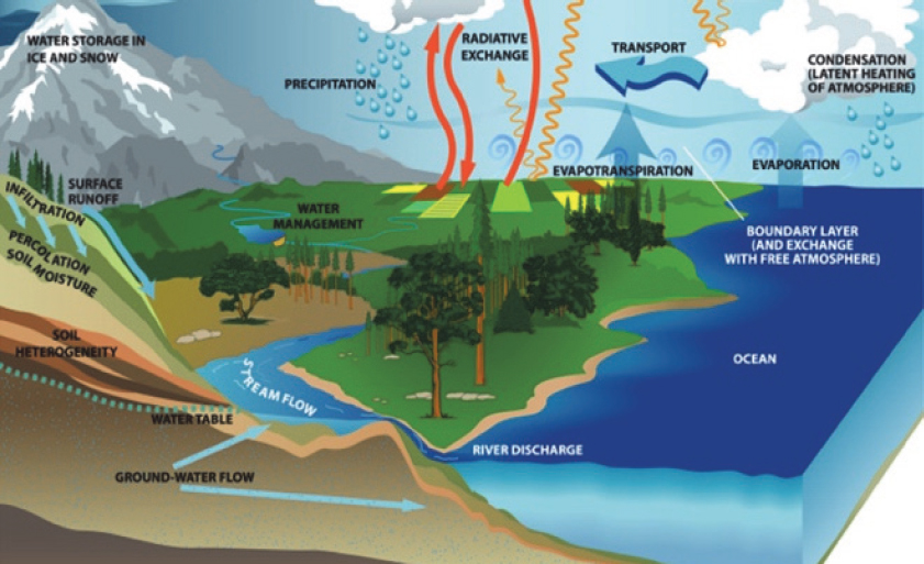
The coupled water and energy cycles are core processes for Earth system dynamics. Water is continuously transforming from one state to another (vapor, liquid, solid) and from one stock to another (ocean, cloud, soil moisture, groundwater, vegetation, surface water, snow, glaciers) via thermodynamic (e.g., sublimation, evapotranspiration
[ET], snowmelt) and transport (e.g., infiltration, percolation, streamflow, atmospheric circulation) processes (Figure 4.1). Moreover, understanding the coupled water and energy cycles also requires quantifying and understanding shortwave and longwave energies modified by atmospheric processes and electromagnetic properties, such as surface albedo. Airborne science plays a basic role in quantifying the states, stocks, and flows of water and the energy involved in changes of these components. Airborne observations contribute to measuring key water and energy cycle variables and processes by serving as instrument testbeds, and supporting algorithm testing and satellite calibration and validation (Cal-Val).
ESAS identified the coupled energy and water cycles as a priority area and an integrating theme, highlighting the complex connections among the components of the Earth system and the societal importance for advancing understanding in this area. Four ESAS questions focus on the coupled water and energy cycles and consider the movement, distribution, and availability of water and how these are changing over time (NASEM, 2018a). Table 4.1 lists these questions and the variables that can be measured from airborne platforms.
This section focuses on H-1 and H-2, which ESAS ranked as most important and are specifically related to fundamental aspects of the coupled water and energy cycles, and to human impacts on climate and land use and how they affect water supply, storage, and demand. H-3 and H-4 are generally lower priority in ESAS and are not addressed here.
Airborne science fills an important role in addressing these water and energy cycles questions by being sufficiently agile to acquire surface and atmospheric measurements across a range of spatial and temporal scales, to use those multi-scale data to refine understanding of the process-relevant scales, to serve as instrument testbeds, and to improve data retrieval algorithms from air and space.
Questions Best Addressed with Large Aircraft and Variables to Be Measured
The DC-8 has not been as widely used for coupled water and energy cycles research when compared with atmospheric science research, but there have been several important airborne campaigns that have specifically benefited from the long-range and heavy-lift capability of the DC-8. Upcoming campaigns also require the special capabilities of the DC-8. Several examples are provided here.
GCPEx. The Global Precipitation Measurement (GPM) mission Cold Season Precipitation Experiment was a 2012 atmospheric airborne science campaign aimed at distinguishing between rainfall and snowfall (Skofronick-Jackson et al., 2015). GCPEx used the DC-8 to carry a large dual-frequency radar (APR-2; Ka, Ku bands) and microwave radiometer (Conical Scanning Millimeter-wave Imaging Radiometer, 50-183 GHz) to measure microphysical properties through the atmospheric column.
CLPX. The Cold Land Processes Field Experiment (Cline et al., 2003, 2009) was a winter 2002 and spring 2003 field and airborne science campaign that required the heavy-lift capacity of the DC-8 to carry the Airborne Synthetic Aperture Radar (AIRSAR) P-, L-, and C-band radar (predecessor to the smaller Uninhabited Aerial Vehicle Synthetic Aperture Radar [UAVSAR]; see Section 2.5d). The overarching goal of CLPX was to acquire nested local- to regional-scale measurements of snowpack properties, soil moisture, and related energy fluxes in order to gain deeper understanding of their transformations to regional and global scales. Airborne radar data were a focus because measurements in the microwave spectrum are relatively insensitive to atmospheric conditions and do not rely on solar illumination, important considerations for snowy regions.
Operation IceBridge. The extreme high latitudes are far from ground support services; thus, the long range of airborne platforms is key. Operation IceBridge (OIB) was an annual field campaign from 2009 to 2019 that filled a gap in the record between the NASA Ice, Cloud, and land Elevation Satellite (ICESat), which failed in 2009, and ICESat-2, which launched in 2018. With remote, multiweek deployments over the Arctic and Antarctic, the DC-8 was critical to the success of OIB. The DC-8 flying science laboratory allowed scientists to monitor dramatic declines in Arctic sea ice and the rapidly changing outlet glaciers of Greenland. Over Antarctica, researchers and their instruments mapped previously unknown ice sheet dynamics, such as the massive crack in Pine Island Glacier that appeared in October 2011. OIB is also discussed in Sections 3.2 and 4.1e of this report.
Table 4.1 2017 Earth Science and Applications from Space Decadal Survey Science and Applications Priorities for Coupling of the Water and Energy Cycles
| Questions That Use Airborne Platforms | Measured Variables | Related ESAS Questionsa |
|---|---|---|
| H-1: How is the water cycle changing? Are changes in evapotranspiration and precipitation accelerating, with greater rates of evapotranspiration and thereby precipitation, and how are these changes expressed in the space-time distribution of rainfall, snowfall, evapotranspiration, and the frequency and magnitude of extremes such as droughts and floods? |
|
H-1a (MI) H-1b (MI) H-1c (MI) W-3a (VI) |
| H-2: How do anthropogenic changes in climate, land use, water use, and water storage interact and modify the water and energy cycles locally, regionally, and globally and what are the short- and long-term consequences? |
|
H-2a (VI) H-2b (I) H-2c (MI) C-2e (I) S-2b (VI) S-4b (I) S-6b (I) |
| H-3: How do changes in the water cycle impact local and regional freshwater availability, alter the biotic life of streams, and affect ecosystems and the services these provide? |
|
H-3a (I) H-3b (I) H-3c (I) |
| H-4: How does the water cycle interact with other Earth system processes to change the predictability and impacts of hazardous events and hazard-chains (e.g., floods, wildland fires, landslides, coastal loss, subsidence, droughts, human health, and ecosystem health), and how do we improve preparedness and mitigation of water-related extreme events? |
|
H-4a (VI) H-4b (I) H-4c (I) H-4d (I) S-6b (I) S-6c (I) |
aThis column includes the most important (MI), very important (VI), and important (I)
designations provided in ESAS. See Appendix D for question descriptions.
ARISE. The 2014 Arctic Radiation IceBridge Sea and Ice Experiment,1 a component of OIB, used the C-130 in its campaign to characterize sea ice surface properties and measure the optical properties of clouds, aerosols, and ice. The goal was to gather key data needed to better understand the changing Arctic energy budget. Based out of Fairbanks, Alaska and using relatively modest instruments, ARISE was able to use the NASA C-130 aircraft rather than the DC-8.
While past campaigns for the coupled water and energy cycles have benefited from the prolonged-duration, heavy-lift, and high-altitude capabilities of the DC-8, similar missions in the future might be carried out without such an aircraft. For instance, future radar campaigns would not require heavy-lift capability since this has been mitigated through development of smaller, lighter replacements (e.g., UAVSAR replacing the AIRSAR; see Section 2.5d). Prolonged-duration capability in the Arctic could be achieved without a DC-8, though long duration will remain important for flights over Antarctica. High-altitude capability has not been a priority requirement for water and energy cycles airborne campaigns. However, for some future campaigns, it may be more scientifically beneficial, logistically effective, and economical if these capabilities are combined in a single aircraft such as a DC-8. Thus, looking to future missions, opportunities for a DC-8like large aircraft are envisioned for coupled water and energy cycles applications.
PREFIRE. The Polar Radiant Energy in the Far-InfraRed Experiment2 is an Earth Venture–Instrument (EVI) mission consisting of a pair of CubeSats. Scheduled for launch in 2021, PREFIRE will measure far-infrared radiances in the water pure rotational bands (50-600 cm-1) to understand how changing Arctic sea ice, open ocean, and Arctic albedo conditions affect the outgoing longwave radiation budget. Arctic Research of the Composition of the Troposphere from Aircraft and Satellites (ARCTAS) and the Atmospheric Tomography mission (ATom) both used the DC-8 to great effect over the Arctic, and this suggests that it could be configured to support PREFIRE Cal-Val activities. The fact that the DC-8 has multiple upward and downward ports makes it appealing for use in a radiation budget experiment such as PREFIRE. Similarly, the DC-8 has flown over Antarctica in the past and could do so again to support comparisons of North Pole versus South Pole outgoing longwave radiation budgets.
ACCP. The Aerosol and Cloud, Convection and Precipitation3 study was identified by ESAS as a designated observable (DO) mission that will not only measure the named atmospheric variables but that has the ultimate goal of better constraining the planetary energy budget. Furthermore, the suborbital component of ACCP will address ACCP
___________________
1 See https://airbornescience.nasa.gov/content/Arctic_Radiation__IceBridge_Sea_Ice_Experiment_ARISE.
2 See https://eospso.nasa.gov/missions/polar-radiant-energy-far-infrared-experiment-evi-4.
science questions that cannot be addressed by satellites as the airborne assets with long on-station and large payload and power capacity can better address convective processes, aerosol–cloud interactions in remote areas, and possibly cold-season precipitation with multifrequency radar, lidar, and passive instruments. It is anticipated that this DO mission will have a significant airborne component (the equivalent of up to about three Earth Venture Suborbital [EVS] campaigns). The ACCP mission will likely require a high-altitude aircraft that can accommodate a large number of instruments with operators, which would be well-served by a large aircraft like the DC-8.
SBG. As another DO mission, Surface Biology and Geology4 will provide information on several coupled water and energy cycles components such as snow and ice accumulation, melting, and albedo; and changing land use effects on energy and water fluxes and water use. As such, the SBG DO is synergistically linked to the ACCP DO for the planet’s coupled water and energy cycles. Cal-Val of SBG measurements will likely benefit from a prolonged-duration aircraft, especially Cal-Val activities in remote polar regions.
Questions Well-Suited to Combinations of Smaller Aircraft
Improved understanding of the fundamental aspects of the water cycle (H-1 in Table 4.1) requires process-relevant measurement scales of water and energy fluxes between land, atmosphere, and ocean via precipitation, ET, snow and ice accumulation and melt, and changes in surface water and groundwater (Trenberth et al., 2007). The ESAS priority areas for water and energy generally need airborne platforms capable of flying at a range of altitudes, speeds, and durations to maximize the usefulness of collected data. Commonly used airborne remote sensing instruments that can address these questions include lidar, hyperspectral (optical and thermal wavelengths), passive microwave, and various types of radars.
For instance, ET varies with vegetation type, moisture availability, solar radiation, and temperature and expresses temporal variability on hourly to seasonal scales and spatial variability depending on heterogeneity of moisture, land cover, and meteorological variables (Dingman, 2015). ET models (Priestly-Taylor, Penman-Monteith) require not only shortwave and/or thermal data but also vegetation type and vegetation structure, including leaf characteristics (Chen and Liu, 2020, and references therein; Still et al., 2019). Thus, quantifying ET, moisture stress, and drought may require spatially-extensive flights repeated over weeks to capture temporal variability and surface heterogeneity using thermal, radar, and spectral data.
Accurate discrimination between rainfall and snowfall is important for water resources management applications such as estimating reservoir inflows and flood forecasting, but ground-based measurements are sparse and often inaccurate, especially in
___________________
mountainous regions. Airborne campaigns have helped assess satellite measurements of precipitation in areas where both rainfall and snowfall occur.
ASO. The Airborne Snow Observatory (Painter et al., 2016), flown on a commercial King Air, measures changes in snow depth using multitemporal lidar alongside a hyperspectral sensor that measures snow surface reflectance to derive snow albedo. Weekly snow depth measurements combined with model-derived snow density produce timely watershed-scale estimates of snow water equivalent for operational water resources management in the California Sierra Nevada (Painter et al., 2016). Frequent availability of aircraft and lower-altitude measurements are key to acquiring the necessary fine-scale data over complex mountain watersheds.
OLYMPEX. The Olympic Winter Precipitation Experiment was a cold-season GPM validation campaign (Cao et al., 2018) over the Olympic Range in Washington that used the ASO instruments on the King Air to measure snow depth as a way to estimate the spatial distribution of snowfall and the rain-snow transition zone.
AirSWOT. As a precursor to the 2021 launch of the Surface Water Ocean Topography (SWOT) radar mission, Air Surface Water and Ocean Topography has demonstrated a robust capacity to accurately measure water surface elevation and slope for large rivers (Altenau et al., 2017) and to estimate reach-scale hydraulics in ungauged remote rivers. AirSWOT carries a Ka-band Interferometric Synthetic Aperture Radar (InSAR), an inertial measurement unit, and a three-band color infrared camera and flies on a King Air B200. The smaller aircraft is well suited to the low and slow needs of capturing river geometry and hydraulics and will be critical to data Cal-Val once SWOT has been launched.
SnowEx. The multiyear SnowEx campaign exemplifies how airborne science enables understanding of coupled water and energy cycles across a range of snow climates including prairie, maritime, tundra, taiga, and alpine. SnowEx goals are to identify the most suitable remote sensing approaches for measuring snow water equivalent and snow albedo at local to global scales. The Airborne Visible/Infrared Imaging Spectrometer Next Generation (AVIRIS-NG5), flown on a Twin Otter aircraft, acquires data needed to compute snow albedo and shortwave energy balance. Airborne microwave measurements are acquired using the UAVSAR L-band radar and Glacier and Ice Surface Topography Interferometer Ka-band radar in a radar pod mounted beneath a modified Gulfstream III (GIII) (NASA Earth Science Airborne Program, 2013). Snow depth and surface topography are mapped using airborne lidar data acquired from a King Air B200. In contrast to CLPX radar measurements, the SnowEx2017 and SnowEx2019 field campaigns used the NASA P-3 rather than the DC-8. For SnowEx, the P-3 is the only aircraft in the current NASA fleet that can accommodate the combination of larger instruments (passive microwave imager, radars) and medium-size sensors (Cloud Absorption Radiometer, Airborne Earth Science Microwave Imaging Radiometer, SnowSAR, infrared [IR], video). The larger microwave imager and radars used for snow
___________________
campaigns do not fit on the DC-8 because of the locations of existing holes, their dimensions, and their airspeed-related engineering requirements (e.g., the DC-8 flies much faster than the P-3, and aerodynamic forces scale as the square or cube of airspeed).
Conclusion 4.1. Addressing ESAS priority areas that advance understanding of the terrestrial water cycle requires observations collected at multiple spatial and temporal scales, which can be conducted on small, agile aircraft that can acquire measurements over a range of altitudes, at different flight speeds, and at multiple times of day.
Conclusion 4.2. Addressing ESAS priority areas that advance understanding of the Earth’s coupled water and energy cycles will likely require (or will significantly benefit from) using a large aircraft, especially for multi-instrument observations in the high latitudes where long-range and heavy-lift capability aircraft are needed. Future missions for ACCP and SBG DOs will benefit from using a large aircraft and will better address some science questions that require suborbital measurements. Smaller airborne platforms will continue to be valuable for coupled water and energy cycles observations across multiple spatial and temporal scales.
Conclusion 4.3. For coupled water and energy cycles questions identified in ESAS, airborne science serves multiple roles including technology development and testing, algorithm development, calibration and validation, operational data collection, and place-based local- to regional-scale studies that incorporate ground-based networks.
Role of Other Airborne Platforms
The committee envisions using some combination of satellite-based sensors, signals of opportunity, in situ sensor networks, airborne sensors, and multiple/simultaneous flights using low-altitude UAS-based sensors (drones) to address the need for multiscale measurements of ET and soil moisture over heterogeneous landscapes, snow depth in remote and complex mountain environments, flood waves moving down large rivers, and other applications. Airborne observations, both high altitude (e.g., 20 km) and low altitude (<400 m), are needed to quantify the key water and energy cycle variables (Table 4.1) at process-relevant scales as a way of understanding fundamental aspects of a changing water cycle. Currently, observation scales between in situ/point scale and high-altitude airborne observations are not addressed and so this is where low-altitude or multialtitude UAS can fill gaps. For instance, small pyranometers mounted on drones can measure land surface albedo at scales from <2 m to 100 m (Sproles et al., 2020). Frequency modulated continuous wave radars on multiple small UAS in a software defined radio platform configuration can be used on UAS to address the lack of high-spatial-resolution observations (e.g., soil moisture at different depths, groundwater table) (Moghaddam, 2020; Prager et al., 2020). Multitemporal images acquired using UAS-mounted cameras and using Structure-from-Motion software can map changes in
surface heights of glaciers, snowpacks, lakes, and reservoirs as well as ground subsidence due to degrading permafrost or groundwater depletion.
Additional Benefits to Earth System Science and Applications Activities for Airborne Platforms
Satellite observations made at fixed spatial and temporal scales are not likely to fully characterize the fundamental scales of heterogeneous water and energy cycle processes such as ET, cloud–aerosol–surface energy budget interactions, atmosphere–ice–ocean interactions, snow accumulation and melt, and extreme events such as floods and debris flows. Airborne measurements provide observations that bridge fine-scale ground data and satellite data. For example, OIB not only filled key data gaps for ICESat but also provided multiscale observations of sea-ice, ice-sheet, and atmospheric properties. The Airborne Microwave Observatory of Subcanopy and Subsurface (AirMOSS), an EV-1 mission with a P-band radar (Tabatabaeenejad et al., 2015) that flew on a GIII, provided high-spatial-resolution measurements of soil moisture and soil freeze-thaw state to better understand coarse-resolution measurements from the Soil Moisture Active-Passive (SMAP) mission. Such multiscale information can also enhance our understanding of fundamental scaling relationships and improve how we represent water and energy cycles in land surface and climate models. Moreover, such efforts serve as a key interdisciplinary linkage between carbon cycle science, ecosystems science, and coupled water and energy cycles science.
Airborne science observations are fundamental to advancing our understanding of coupled water and energy cycles through developing trusted algorithms and datasets with known uncertainties, as a step toward a satellite mission, to build a community of data producers and expert data users prior to a satellite mission, and to create validation datasets for use with planned satellite missions.
4.1b Physics and Dynamics for Improving Weather Forecasts
Earth’s weather and climate systems are strongly influenced by the interactions between the atmosphere and land, ocean, and sea ice surfaces, the radiation from the sun, and by the release and redistribution of latent and radiative heating. These complex interactions and processes include the exchange of mass, momentum, and energy between underlying surfaces and the planetary boundary layer (PBL) and between the PBL and the free troposphere; interactions of convective systems with the surrounding environment; cloud microphysical processes; and the interaction of atmospheric constituents with radiation. Better understanding of the physical and dynamical processes occurring in the atmosphere is essential to improve weather and climate models (Benjamin et al., 2018; Kristovich et al., 2019; LeMone et al., 2019; Randall et al., 2018) and to extend and improve weather forecasts.
Convective processes that occur in the tropics (Emanuel, 2018) and mid-latitudes (Schultz et al., 2019) and result in phase changes of water (Houze, 2018, and references therein) are among the processes with the strongest impact on weather and climate. Being able to predict the formation of convective storms and their evolution into severe weather such as thunderstorms and tropical cyclones is critical for improving weather forecasts. The organization of convection and its coupling with large-scale weather systems is the key for extending the fidelity of weather forecasts beyond 2 weeks (e.g., Daleu et al., 2016; Malardel and Bechtold, 2019).
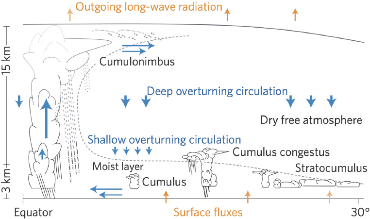
Understanding how clouds and atmospheric circulations interact is not only important for weather forecasting but is essential for projecting future changes in Earth’s climate. Clouds are among the key drivers of Earth’s climate system, and this includes both low clouds, which interact with other components within the PBL and the attendant feedback on the atmospheric circulation (Bony et al., 2015), and deep convective clouds that are effective distributors of mass, momentum, and energy throughout the depth of the troposphere. Small-scale processes occurring in clouds and conversions between different water phases generate latent heat, which in turn affects air motions and ultimately dynamical processes affecting the cloud properties themselves (Kreidenweis et al., 2019, and references therein; Stephens, 2005). The interactions of clouds with solar and IR radiation also affects the distribution of radiative heating in the atmosphere, with feedback on atmospheric motions and dynamics, and affects the distribution of cloud properties themselves (Bony et al., 2015). As illustrated in Figure
4.2, clouds and atmospheric circulations are intrinsically linked, and there is a complicated interplay between cloud microphysics, cloud dynamics, radiation, and atmospheric circulation.
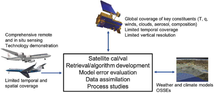
Airborne measurements represent a key component of the integrated observing system to advance understanding of the PBL, free troposphere, air-sea fluxes, clouds, aerosols, and convective and radiative properties. Airborne measurements are also an essential complement and validation platform for spaceborne observations and provide a link between the space- and ground-based measurements. Aircraft can also serve as a validation platform for atmospheric observations from the ground up over land, snow, and ice, and to provide data for climate models as part of an integrated research strategy in this field (Figure 4.3).
ESAS identified key outstanding questions that are fundamental to improving and extending weather forecasts, including questions where airborne platforms serve an important role. These include foci on processes within the PBL, controls on convective storms and heavy precipitation, in-cloud microphysical processes, and interactions between clouds and radiation (Table 4.2).
Questions Best Addressed with Large Aircraft and Variables to Be Measured
To advance understanding of physical and dynamical processes outlined in the ESAS priority areas, throughout the depth of the troposphere, comprehensive airborne observations are needed of atmospheric dynamic and thermodynamic processes,
Table 4.2 2017 Earth Science and Applications from Space Decadal Survey Science and Applications Priorities for Physics and Dynamics for Improving Weather Forecasts
| Questions That Use Airborne Platforms | Measured Variables | Related ESAS Questions |
|---|---|---|
| W-1: What planetary boundary layer (PBL) processes are integral to the air-surface (land, ocean, and sea ice) exchanges of energy, momentum, and mass, and how do these impact weather forecasts and air quality simulations? |
|
W-1a (MI) C-4a (VI) C-4b (I) C-4c (I) |
| W-4: Why do convective storms, heavy precipitation, and clouds occur exactly when and where they do? |
|
W-4a (MI) H-1a (MI) H-1b (MI) |
| W-9: What processes determine cloud microphysical properties and their connection to aerosols and precipitation? |
|
W-9a (I) |
| W-10: How do clouds affect the radiative forcing at the surface and contribute to predictability on timescales from minutes to subseasonal? |
|
W-10a (I) |
weather systems, and in-cloud processes that span a wide range of spatial and temporal scales (e.g., Chen et al., 2016). Aircraft that can simultaneously support a broad range of remote and in situ instruments have been and will continue to be the key platforms for weather- and climate-focused airborne investigations in this science area. Historically, the DC-8 has been a key large aircraft used in physical and dynamical weather studies, with an extensive list of field campaigns that have benefited from its heavy-lift, long-range capabilities over several decades of it being in service of the scientific community (e.g., Tropical Ocean-Global Atmosphere Coupled Ocean-Atmosphere Response Experiment [TOGA COARE; Webster and Lukas, 1992]; Kwajalein Experiment ([Yuter et al., 2005]; Convection And Moisture EXperiment -3/4 [CAMEX 3/4; Kakar et al., 2006]; NASA African Monsoon Multidisciplinary Analyses [NAMMA; Zipser et al., 2009]; Tropical Composition, Cloud and Climate Coupling Experiment [TC4; Toon et al., 2010]; Genesis and Rapid Intensification Processes [GRIP; Braun et al., 2010]; Deep Convective Clouds and Chemistry Project/Studies of Emissions, Atmospheric Composition, Clouds and Climate Coupling Regional Surveys [DC3/SEAC4RS]; Plains Elevated Convection at Night [PECAN; Geerts et al., 2017]; and Convective Processes Experiment [CPEX; Chen et al., 2020]).
Starting from the surface of Earth and going up, the PBL is the first layer of the atmosphere where detailed observations are required to advance understanding of physical processes relevant to weather and climate. Accurate, diurnally resolved kinematic (wind) and thermodynamic (temperature and moisture) profiles are needed throughout the depth of the PBL, as well as across it into the free troposphere, to evaluate the full three-dimensional PBL structure, its dynamical evolution, and its coupling to the atmospheric circulation processes above it (W-1). Vertical profiles of fluxes of kinematic and thermodynamic fields are needed to ascertain the accuracy of model representation of processes throughout the depth of the PBL and at the interface with the lower boundary and the free troposphere. At the lower boundary, vertical fluxes are needed to improve our understanding of the air-sea exchanges as well as the exchanges between the atmosphere and the biosphere. A suite of sensors essential for high-resolution vertical and temporal profiling of PBL temperature, moisture, and heights include microwave, hyperspectral IR sounder(s) (e.g., in geo or small-satellite constellations), global positioning system (GPS) radio occultation for PBL temperature and humidity and heights, differential absorption lidar for water vapor profiling, and backscatter lidars for PBL height. Airborne atmospheric measurements of the PBL, in addition to in situ measurements, rely on active remote sensors (wind and backscatter lidars, radars, and scatterometers) or on vertical profiling using dropsondes. The comprehensive suite of in situ, passive, and active remote sensors, combined with an extensive horizontal coverage needed to obtain representative measurements of the PBL, especially the cloud-covered PBL, call for a large aircraft with DC-8-type capabilities (LeMone et al., 2019; NASEM, 2018b).
Research questions pertaining to clouds (W-4, W-9, and W-10) require a multiscale approach with observations collected on spatial scales ranging from hundreds of meters
to thousands of kilometers and temporal scales of minutes to days using an aircraft with sufficiently long range and duration to sample the variety of spatial and temporal scales. The long-range capability is needed to measure properties such as cloud particle numbers, sizes, and masses as well as winds, water vapor, and temperature in low PBL clouds. Long range is also necessary for study of high ice clouds and convective clouds, and warm rain showers from isolated convection which require long sampling periods to capture cloud systems at various stages of their life cycle (Rauber et al., 2007). A large aircraft is required because separate probes are needed for direct measurements of wind, clouds, and humidity as well as remote sensors to give the context of these measurements, and the capability to carry powerful remote sensors such as dual-Doppler and dual polarization radars capable of storm penetration. Long-range capability is also important for documentation and measurements of processes in many remote locations including the Polar regions (McFarquhar et al., 2020) and equatorial Pacific. The direct and remote sensing measurements could be taken with two smaller aircraft with the needed range (e.g., the Gulfstream V [GV]), but the long transit complicates coordination to sample the same area and the payloads can be insufficient. A long-range aircraft capable of making measurements on timescales of days, and conducting sampling following air parcels, would advance the ability to track a weather system and understand how it evolves as it moves with the background flow.
Measurements of cloud, aerosols, radiative properties, and precipitation throughout the troposphere to inform understanding of convective processes are needed to address ESAS priority areas W-9, W-10, and W-4. Co-located measurements of a large suite of aerosol and cloud properties are needed to identify physical processes by which they are connected, to understand how aerosols directly and indirectly modify Earth’s water and energy budgets, and for development of numerical models and evaluation of model simulations and remote sensing retrievals. Importantly, many of the needed measurements require vertical profiling and a large aircraft capable of observations over a wide range of altitudes extending from beneath the cloud base up to the upper troposphere/lower stratosphere. For tropical studies, this might go well beyond 14-15 km above sea level (ASL). On the other hand, for PBL measurements including shallow convection, the altitude range requirement is relatively modest at 1-2 km ASL and/or above ground level (AGL). Thus, measurements are required not only at a large range of altitudes but also in a wide variety of cloud systems. The properties that need to be measured at these altitudes and in the variety of cloud conditions to address these issues are provided in Table 4.2.
Multisensor campaigns with simultaneous remote-sensing and in situ measurements are essential for achieving the needed progress on cloud-precipitation dynamics in PBL studies and for cloud and precipitation studies in general (e.g., Wielicki et al., 1995). Remote sensing instrumentation to address this research includes passive remote sensing at both narrow and broadbands in the solar, near-IR, and IR spectrum, as well as radar and lidar measuring at multiple wavelengths and polarizations for detecting different parts and components of the clouds and microwave radiometry. The remote
sensing instruments need to see the same cloud where in situ observations are being made and to simultaneously observe atmospheric properties outside the storm at a variety of scales. Although there has been progress in reducing the size of some instruments, there are still many that are large with high power requirements (e.g., remote sensing devices, aerosol composition analyzers, a continuous flow diffusion chamber measuring ice nucleating particles, cloud microphysical probes measuring water and ice). For in situ measurements collected on board, aircraft need to be equipped with a variety of probes including some mounted on the aircraft fuselage or under the aircraft wings. Others require supporting inlets, providing the ability to sample a range of possible aerosol and cloud particle sizes, their phases, and bulk properties (e.g., mass and extinction) as well as measuring wind, temperature, moisture, and vertical motion at small scales. The aircraft layout also needs to be flexible to accommodate different sets of instruments for different deployments. In addition to a large payload, the range and duration required for such measurements are immense.
For studies of cloud–radiation interactions (W-10), aircraft observations complement, enable, and evaluate spaceborne observations and retrieval. This requires multiple remote sensors in order to maximize the information about the three-dimensional structure of the cloud that cannot be obtained through in situ observations. Some of the main unanswered questions in this area, such as why there is a lack of agreement between Earth system models and satellite retrievals of shortwave radiation over the Southern Ocean (Bodas-Salcedo et al., 2014) and the origin of the El Niño–Southern Oscillation (Dai and Arkin, 2020) for which observations of radiative fluxes over the equatorial Pacific where large temperature gradients exist (Ramanathan et al., 1994) are needed, require sampling in remote areas, and therefore require a long-range aircraft. For studies of clouds and radiative forcing, an aircraft that can fly long, level legs at the same altitude is preferred, as well as an aircraft that can fly at the maximum possible altitudes, especially in the tropics, to investigate questions about radiative forcing.
Conclusion 4.4. To obtain comprehensive sets of measurements covering a wide range of temporal and spatial scales needed for advancement of science questions in the weather area, a large aircraft is necessary to meet the requirements for flight duration (about 10 hours or longer), altitude range (from 1-2 km up to at least 15 km), and large payload capacity to carry lidars, radars, and in situ onboard and deployable instruments.
Conclusion 4.5. A large aircraft capable of carrying remote sensors with storm/convection penetration capability (scanning radars) that can target and enable measurements in high-impact weather is needed to address ESAS priorities.
Questions Well-Suited to Combinations of Smaller Aircraft
Smaller aircraft are a preferred platform for documentation of horizontal variation of kinematics and thermodynamics of PBL structures and fluxes and for near-coastal PBL
studies (W-1). There are also science questions in priority area W-9 that can be addressed with combinations of smaller aircraft when large aircraft are not available. For example, multi-aircraft studies can provide a large amount of data and statistics on the properties of aerosols (aircraft flying below cloud), clouds (aircraft flying within cloud), and radiation/remote sensing (aircraft flying above cloud) parameters (e.g., Ramana et al., 2007). However, this approach is frequently complicated by different true air speeds of each aircraft and by the coordination of aircraft, especially at remote locations, as well as cost and logistical complications.
The use of multiple smaller aircraft can be useful to address specific questions. For example, small aircraft with the appropriate capabilities could provide information in intense updrafts and downdrafts to provide insights on questions related to W-4. Similarly, a medium-size aircraft able to fly in conditions such as supercooled water or drizzle to measure cloud, wind, temperature, and humidity can also provide valuable information about processes controlling the amount and phase of precipitation, but would need to be accompanied by another aircraft remotely sensing the cloud system to provide the context for the in-cloud measurements. Two or more aircraft flying in coordination are also effective for flying simultaneous legs above or below cloud at the same time as a leg within cloud. For example, the Aerosol-Cloud-Meteorology Interaction Airborne Field Investigations (ACTIVATE) campaign used two aircraft that were able to stay coordinated even with some wind differences at the altitudes the aircraft were flying at (Sorooshian et al., 2019). The acquisition of coincident remote sensing and in-cloud measurements could also be accomplished with a single long-duration aircraft, provided the aircraft was able to fly at multiple altitudes at subsequent times and the temporal evolution of the system was slower than the time needed to make repeated passes through the system.
There are also science questions related to cloud radiative forcing (W-10) that can be addressed by combinations of smaller aircraft when large aircraft are not available. For example, to get profiles of radiation and information on radiative heating rates, medium-size aircraft flying at multiple altitudes, measuring radiation above and below the clouds at the same time and horizontal position as in situ cloud and aerosol microphysical properties are required, something that is not possible with a single long-duration aircraft (Ramanathan et al., 2007). Long-range aircraft that can stay in the air for long periods with room for multiple sensors could still be valuable in multiple aircraft deployments as the wide complement of remote sensors and radiative flux measurements could be important for getting the three-dimensional structure inside the cloud, provided they are used in coordination with other aircraft flying at different altitudes.
Role of Other Airborne Platforms
UAS have an important role in addressing the ESAS priority areas by complementing aircraft measurements. This is especially true in airborne PBL research given that piloted aircraft cannot fly lower than about 300 m (1,000 ft) AGL when clouds are present, limiting their ability to directly measure properties in the lower PBL. The agility and easier maneuverability of such platforms allows one to come closer to the lower boundary, which in some cases more than compensates for their smaller payload capacity.
Fleets of small to medium-size UAS can be used to address PBL questions (W-1) that require high maneuverability. Needed measurements include those of aerosol properties, cloud properties, temperature, humidity, and winds. Smaller UAS are able to fly in coordination to collect data above, within, and below cloud layers in order to improve quantification of cloud and aerosol properties on vertical distributions of latent heating, especially since some in situ aerosol and cloud probes have been miniaturized. Small UAS also permit observations of all such properties at lower altitudes than piloted aircraft, and hence can measure boundary-layer properties closer to the surface. The unique ability to sample close to the surface is also beneficial for addressing radiative forcing questions (W-10), where observations at a wide range of altitudes are required. It is also possible that UAS could be deployed from oceanic research vessels for observations close to the water over remote oceans.
Measurements from long-duration UAS or stratospheric balloons could now have the capability of tracking the evolution of weather phenomena that have long lifetimes, such as the evolution of tropical cyclones, where it is important to observe the process of rapid intensification; the complete life cycle of cyclones as they traverse the United States; and collection of routine statistics on various meteorological phenomena.
Finally, measurements of cloud particles, winds, temperature, and humidity in convective cores are almost nonexistent because current airborne platforms, both piloted and uncrewed, are not able to safely penetrate convective cores with large updraft speeds. Condensate is generated and heat is released in these updrafts, which contributes significantly to precipitation, severe and high-impact weather, Earth’s cloud cover, and the redistribution of the energy, both horizontally and vertically. The lack of measurement within cloud convective cores has a considerable impact on the ability to forecast weather systems and on understanding of how aerosols affect future climate scenarios. Although it is unlikely that a large aircraft with long endurance and large payload would be able to fulfill this requirement, a complementary convective-penetrating aircraft available from some agency would be beneficial.
Conclusion 4.6. Smaller aircraft and UAS have important supplementary roles in advancing ESAS priority questions, including their abilities to penetrate cloud and storm systems and to sample at low altitude in the PBL.
Additional Benefits to Earth System Science and Applications Activities for Airborne Platforms
A new generation of in situ and remote sensing instrumentation is currently under development that will improve the ability to measure important weather-related properties. These include in situ probes for accurate characterization of mass, small ice crystal concentrations (e.g., holographic cloud particle detectors, high-resolution particle imagers), multiwavelength and polarization lidars, scanning radars and lidars, and phased-array weather radar. As is true in other disciplines (and discussed in Section 2.5d), most initial versions of probes are large and require an aircraft with large payload capability. Furthermore, to evaluate the performance of new probes, it is critical that they fly in coordination with existing probes to demonstrate accuracy and allow for comparison against existing probes (McFarquhar et al., 2011).
4.1c Air Quality and Atmospheric Chemistry—Chemistry Coupled to Dynamics
The composition of the atmosphere continues to undergo rapid change due to anthropogenic activity associated with economic development, energy use, agriculture, and land use and other changes. These changes affect air quality, stratospheric ozone, climate, and feedbacks with ecosystem dynamics (e.g., wildland fires, Arctic permafrost thaw). Understanding changes in atmospheric composition and its implications for the Earth system from regional to global scales requires a full accounting of both natural and anthropogenic emissions of a wide variety of species to the atmosphere, their atmospheric processing including chemical evolution and transport, and various loss processes out of the atmosphere, all of which occur over a vast range of spatial and temporal scales (e.g., NASEM, 2016). Disentangling the effects of emissions and of chemical transformations on atmospheric composition and the resulting chemical and radiative properties requires a large number of variables to be measured that are co-located in space and time.
The atmosphere is also rapidly moving with respect to Earth’s surface while emissions are being added and chemical transformations are occurring, which adds some additional measurement challenges compared to the study of many land-, ocean-, and cryosphere-based surface processes discussed in other sections that largely focus on remote sensing of the surface from airborne and spaceborne instrumentation. These measurement challenges in the study of atmospheric chemistry coupled with atmospheric dynamics have been met most successfully in the troposphere and parts of the lower stratosphere using the long-duration, heavy-lift DC-8 aircraft to make detailed in situ observations throughout the atmosphere (e.g., Barth et al., 2015; Crawford et al., 2021; Fishman et al., 1996; Hoell et al., 1996, 1997, 1999; Jacob et al., 2003, 2010; Raper et al., 2001; Singh et al., 2006, 2009; Toon et al., 2016). These airborne observations—combined with spaceborne measurements of a necessarily more limited number of species and computer models—constrain many of the variables over wide ranges of
space and time inherent in understanding atmospheric composition and how it is changing over time.
Atmospheric chemistry coupled with dynamics plays a fundamental role in addressing multiple ESAS questions and objectives. Table 4.3 highlights four major questions in atmospheric chemistry and maps them onto a number of specific ESAS questions and objectives that are deemed “Most Important” for three science and applications areas: Extending and Improving Weather and Air Quality Forecasts, Ecosystem Change, and Reducing Climate Uncertainty and Informing Societal Response. Table 4.3 also indicates the types of measurements needed to answer these questions; for clarity, they are given in a grouped format in Table 4.3, while a much more detailed view of individual species measured as well as their spatial and temporal resolutions are given in Table E.1 (Appendix E). The large number of variables reflects the complexity of atmospheric chemistry and the need to trace and follow this chemistry in space and time.
This complexity includes emissions of both natural and anthropogenic compounds, chemical transformations taking place as air moves and mixes over time into different chemical and physical (i.e., temperature, pressure, actinic flux) regimes, and the presence of atmospheric oxidants emitted or produced by secondary photochemistry that react to form aerosols, initiating new chemistry and affecting clouds and precipitation and radiative transfer (e.g., NASEM, 2016). For example, some of the most important atmospheric constituents are not emitted directly into the atmosphere. Rather, their abundance is regulated by the chemical processing of other emitted compounds. This is the case for both ozone and a dominant fraction of atmospheric aerosols (e.g., Heald and Kroll, 2020). Thus, a continued focus on atmospheric oxidation chemistry is needed to understand the chemical transformations controlling the cycling of atmospheric constituents and the impact on distributions of key pollutants, including ozone and aerosols. This requires concurrent observation of emitted precursor compounds, radical oxidants, chemical intermediates and products, solar radiation across photochemically active wavelengths, and meteorological variables that together govern the atmospheric chemical processes that determine the temporal and spatial gradients in atmospheric composition. Each of these is intertwined in the fundamental questions (i) through (iv) in Table 4.3. Another example is that, while anthropogenic emissions are of fundamental importance as drivers of change, their interaction with natural emissions is also important, leading to differences in regional outcomes for air quality (e.g., NASEM, 2016). Source-specific tracers and speciated volatile organic compounds (VOCs) are needed to track the sources and transformations of these species, while atmospheric oxidants determine air quality, and are thus also intertwined in questions (i) through (iv).
Thus, while the four questions in Table 4.3 are distinct, they are not truly separable and usually cannot be studied in isolation. This is why there is little to no difference in the suite of measured variables listed for each question and why different airborne campaigns often contribute to advancing understanding of several of these questions
despite an emphasis on one or two particular questions. The relative importance of various measurements may change, however, depending on the question. The designations (critical/important/useful) are intended as a rough guide since even the very large payload capacity of an aircraft such as the DC-8 cannot accommodate all instrumentation to measure all variables listed in Table E.1 relevant for addressing ESAS questions (i)-(iv), and, ultimately, measurement payloads will be tailored to the priorities and goals for each specific airborne study. The detailed list of variables in Table E.1 also includes additional information on the historical progression in the number and quality of variables that have been measured. The large number of variables and the payload size this dictates, and, as will be discussed later, the maturation in capability to measure atmospheric composition more completely, are some of the many factors that drive the need for continued heavy-lift, long-range capability for airborne science to answer ESAS questions involving atmospheric chemistry coupled with dynamics.
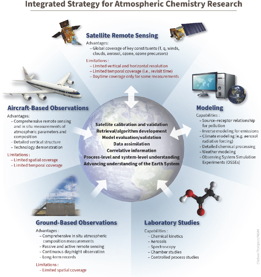
To fully appreciate the role of airborne science in advancing atmospheric chemistry understanding—both in past successes and in continuing to address questions (i) through (iv) in Table 4.3—airborne science must be placed in the context of the integrated strategy depicted in Figure 4.4 involving spaceborne, airborne, and ground-based measurements combined with modeling (see also Section 2.2). Satellites play the critical role of providing observations with broad, regular coverage of a limited number of constituents, although they are some of the most important. These include ozone in both the stratosphere and troposphere, carbon monoxide (CO, a marker of inefficient combustion from fires and human activity), nitrogen dioxide (NO2, dominated by anthropogenic fossil fuel combustion), formaldehyde (CH2O, an indicator of total hydrocarbon oxidation), sulfur dioxide (SO2, from volcanic and industrial sources), ammonia (from agricultural activities), carbon dioxide (CO2) and methane (CH4, key greenhouse gases affected by changing anthropogenic and natural sources), and aerosol optical depth (used to track fine particulate matter from myriad sources such as fires, dust storms, and urban pollution). Ground-based observations can provide continuous measurements of many more species than can be measured from space but only for discrete locations. Although airborne observations cannot be maintained with either the spatial or temporal continuity of the satellite and ground perspectives, the airborne perspective is critical to their interpretation. For example,
- Satellite observations need information on detailed chemical composition that cannot be measured from space in order to enable process-level understanding of observed distributions and changes,
- Satellite observations need information on vertical structure in constituent distributions through the troposphere and into the stratosphere when possible,
- Satellite observations are limited in frequency and duration at any given location and thereby miss important information about diurnal processes governing chemistry and transport,
Table 4.3 2017 Earth Science and Applications from Space Decadal Survey Science and Applications Priorities for Air Quality and Atmospheric Chemistry—Chemistry Coupled to Dynamics
| Questions That Use Airborne Platforms (and ESAS Questions of Relevance) | Measured Variablesa | Related ESAS Questions |
|---|---|---|
| (i) What are the levels and drivers of air pollution in different regions of the world? | Critical: Ozone and reactive nitrogen species, aerosol physical and chemical properties, speciated volatile organic compounds (VOCs) Important: Source-specific tracers, carbon cycle and greenhouse gases, oxidants and reservoir species, photochemical actinic flux, meteorological variables |
C-3b (I) W-5a (MI) W-6a (I) W-7a (I) W-8a (I) |
| (ii) What controls the concentrations of atmospheric oxidants? (C-3, C-9, W-5, W-6, W-7, W-8) | Critical: Oxidants and reservoir species, photochemical actinic flux, ozone and reactive nitrogen species, speciated VOCs Important: Carbon cycle and greenhouse gases, meteorological variables, source-specific tracers, aerosol physical and chemical properties |
C-3g (I) C-9a (I) W-5a (MI) W-6a (I) W-7a (I) W-8a (I) |
| (iii) What are the sources and properties of aerosols in relation to climate forcing? (C-2, C-5, W-5, W-6) | Critical: Aerosol physical, chemical, and radiative properties Important: Source-specific tracers, speciated VOCs, ozone and reactive nitrogen species, meteorological variables, carbon cycle and greenhouse gases Useful: Photochemical actinic flux |
C-2h (MI) C-5a (VI) C-5b (I) C-5d (I) W-5a (MI) W-6a (I) |
| (iv) What are the carbon fluxes from global scale down to point sources? (C-3, E-2, W-6, W-7, W-8) | Critical: Carbon cycle and greenhouse gases, meteorological variables Important: Speciated VOCs, source-specific tracers Useful: Aerosol physical and chemical properties, ozone and reactive nitrogen species |
C-3a (VI) C-3b (I) C-3e (I) C-3g (I) E-2a (MI) W-6a (I) W-7a (I) W-8a (I) |
aCritical = Must have with best possible quality; Important = Needed to fully address the science; Useful = Can provide valuable context.
- Satellite observations are limited in cloudy conditions that are important to sample for a full understanding of atmospheric chemical and dynamical processes, and
- Ground observations are heavily influenced by PBL dynamics and chemical conditions aloft that often involve strong vertical gradients in composition.
Airborne measurements thus provide critical information about the distribution of species and the processes occurring within the atmosphere that space and ground-based remote sensing and in situ sampling at the ground alone cannot provide.
Airborne science has also played and will continue to play a critical role in improving atmospheric and Earth system models. Earth system models and chemical transport models are the tools for predicting future impacts of atmospheric composition changes and feedbacks between the atmosphere and other components of the Earth system. They, too, are critical for answering ESAS questions (i)-(iv) and will ultimately enable operational forecasts of, for example, air quality, as well as exploration of scenarios for emission controls to inform decision making. While the continuity of satellite- and ground-based observations can help identify geographic areas of scientific priority to study in answering ESAS questions (i)-(iv), airborne observations of a large number of chemical constituents are needed to provide more detailed evaluation of model performance for these locations. Detailed evaluations are key since air-quality models can (and in many cases must) include a large number of constituents (e.g., several hundred species in the Goddard Earth Observing System [GEOS]-Chem model).6
The role of fundamental investigations in the controlled setting of a laboratory cannot be underestimated in this framework. The chemical mechanisms in models rely on extrapolations from known laboratory kinetics (e.g., Master Chemical Mechanism7) and parameterizations of complex VOC oxidation and gas-to-particle conversion supported by chamber studies. To demonstrate accuracy, these mechanisms must be tested against a large number and variety of in situ observations. Indeed, important model-measurement discrepancies have often been attributed to mechanisms or species that are not yet in the model (e.g., Barrie et al., 1994; Li et al., 2014; Millet et al., 2015; Taraborrelli et al., 2012; Wang et al., 2014; Wennberg et al., 1998). Working hypotheses to explain discrepancies have in turn been investigated in laboratory experiments (e.g., Wennberg et al., 2018) and tested by adding a new measurement or an improved instrument to an already large airborne payload for subsequent measurement campaigns (e.g., Bradshaw et al., 1999; Brune et al., 2020; Fisher et al., 2016; Salawitch et al., 2010). Similarly, while models are well equipped to handle large-scale dynamics,
___________________
6 See http://wiki.seas.harvard.edu/geos-chem/index.php/Species_in_GEOS-Chem#Fullchemistry.
7 See http://mcm.york.ac.uk/.
at smaller scales (e.g., deep convection, diurnal boundary-layer dynamics, fire weather, and land-sea breezes), models are still challenged to realistically capture these influences and the corresponding responses in atmospheric composition and chemistry. Airborne observations have played an essential role in mechanistically constraining these processes and determining how best to parameterize them in models (e.g., Bela et al., 2016; Loughner et al., 2014; Zhang et al., 2016).
Looking forward, the continued maturation of the integrated research strategy for atmospheric chemistry in Figure 4.4 will be needed to achieve the ESAS science priorities for which atmospheric chemistry plays a role. The following sections critically examine the role of heavy-lift, long-range, and other aircraft in supporting these priorities.
Questions Best Addressed with Large Aircraft and Variables to Be Measured
The atmospheric chemistry questions outlined in Table 4.3 and ESAS are longstanding questions that have been pursued and advanced as the technological capacity to address them over time has matured. Because of its large payload that can be carried across long distances and through an extensive range of altitudes, the DC-8 has served as a workhorse for this atmospheric chemistry research over the past three decades, enabling discoveries to be made in different regions of the atmosphere and connecting space- and ground-based measurements and models. The advances in addressing these questions have stemmed in large part from the progression in the numbers of species measured and the accuracy, precision, and time resolution of the instruments that measure them, which are shown in Table E.1, as well as the capability for including them in a single heavy-lift payload. While Table E.1 provides much more specific information than Table 4.3, note that the growing complexity and scientific capability of the DC-8 is still not explicitly represented since many compounds are still listed in groups of compounds and measurement categories. For instance, the archived dataset for the Pacific Exploratory Mission in the western Pacific phase A (1991) included 72 measured variables compared to 576 for the most recent Fire Influence on Regional to Global Environments and Air Quality (FIREX-AQ, 2019) campaign.8
Alongside the advances in measurement capabilities on the DC-8, other parts of the observing system have also matured with a growing list of satellite instruments (e.g., Measurement of Pollution in the Troposphere, Ozone Monitoring Instrument, Global Ozone Monitoring Experiment-2, Moderate Resolution Imaging Spectroradiometer [MODIS], Multi-angle Imaging SpectroRadiometer, Atmospheric Infrared Sounder, Tropospheric Emissions Spectrometer, Cloud-Aerosol Lidar and Infrared Pathfinder Satellite Observation, Orbiting Carbon Observatory 2, TROPOspheric Monitoring Instrument [TROPOMI]) requiring the integration of airborne and satellite perspectives.
___________________
8 Data available at https://www-air.larc.nasa.gov.
Similar progress has been made in the use of models, which were first used to guide flight planning during Transport and Chemical Evolution over the Pacific (TRACE-P; Jacob et al., 2003). The integration of models into campaign planning has been especially valuable for evaluating the prognostic capability of models. During the recent Korea-United States Air Quality (KORUS-AQ) study (Crawford et al., 2021), six different air quality modeling teams participated in the campaign, which enabled detailed intercomparison of the models against each other in the context of detailed observations. As these parallel advances in airborne, satellite, and models progress, the integrated strategy in Figure 4.4 will continue to dictate airborne science demands into the future and the types of measurements and measurement platforms needed to continue to make progress in answering the ESAS questions. That the heavy-lift, long-duration DC-8 is nearing the end of its useful lifetime significantly jeopardizes progress toward answering questions (i)-(iv) through this integrated strategy over the coming decade as the investment and capabilities in spaceborne instrumentation come to fruition.
A brief list of integrated science accomplishments that relied on the heavy-lift capability of the DC-8 over the past decade provides a point of reference for what is currently possible going forward into the next decade and beyond. The DC3 (Barth et al., 2015) and SEAC4RS (Toon et al., 2016) missions enabled detailed observation of convective impacts on composition and chemistry that affect the global reach of anthropogenic and natural emissions and affect vertical structure in constituents observed from space. SEAC4RS observations of isoprene and its oxidation products enabled the evaluation of a decade of research into the detailed chemistry of this globally dominant VOC which is intimately tied to oxidation rates and satellite observations of CH2O (e.g., Fisher et al., 2016). The KORUS-AQ mission (2016) exposed gaps in understanding the complexity of Asian anthropogenic emissions that were found to be poorly represented in models along with shortcomings in model mechanisms for aromatic chemistry that was key to both ozone formation and secondary organic aerosol (i.e., smog) (e.g., Oak et al., 2019). KORUS-AQ also revealed model shortcomings in representing the interplay between transboundary transport, local emissions, and meteorological factors influencing secondary aerosol formation (Jordan et al., 2020). These lessons are critical to future interpretation of air quality observations from satellites in geostationary orbit. The FIREX-AQ and SEAC4RS missions also provided critical observations of fire emissions and subsequent smoke plume chemistry and dynamics to improve model representation of the environmental and air quality impacts of wildland fires and prescribed fires (e.g., Liu et al., 2016; Saide et al., 2015). See Section 4.2b for additional discussion of wildland fire. With satellites being the only viable route to incorporating fire emissions into models, these DC-8 airborne observations will be critical to improving how satellite fire data are assimilated into models. Finally, the ATom mission (2016-2018) provided a global perspective on the large-scale impact of emissions, chemistry, and transport on the remote atmosphere, providing a critical test of global models (Wofsy et al., 2018).
Going forward, the integrated research strategy involving airborne, spaceborne, and ground-based observations and models to address ESAS questions will become even more important with the launch of several satellites that are part of the decadal survey program of record, specifically, Tropospheric Emissions: Monitoring Pollution (TEMPO), Multi-Angle Imager for Aerosols (MAIA), and Geostationary Carbon Observatory (GeoCARB). TEMPO will be launched into geostationary orbit to measure over North America in 2022 and will join an international constellation of air quality satellites (CEOS, 2019) including TROPOMI (in low Earth orbit [LEO] since 2017) providing global coverage, Geostationary Environment Monitoring Spectrometer (in geostationary Earth orbit [GEO] since 2020) observing Asian countries, and Sentinel-4 planned for launch into GEO over Europe and North Africa in 2023. This collection of satellites will afford hourly observations of air quality from space for the first time, enabling top-down emission estimates and assessment of regional air quality chemistry as it is affected by emissions, transboundary transport, and meteorological conditions. MAIA also will be be launched into LEO in 2022. It will be more narrowly focused on specific megacity airsheds to characterize the abundance and composition of aerosol pollution where some of the biggest problems exist. Many of these airsheds will be within the fields of view of the geostationary instruments, providing valuable synergy between precursor emissions and secondary aerosol pollution.
To be fully successful, however, airborne observations of the large suite of measurements listed in Tables 4.3 and E.1 will be needed to document the complex chemical details necessary to conduct source apportionment analyses, assess oxidation rates, and provide process-level information on the formation rates of ozone and secondary aerosol pollution from precursors. Also relevant for addressing relevant ESAS questions is the recent World Meteorological Organization initiative, Global Air Quality Forecasting Information System, which will bring engagement from the international modeling community to identify where air quality forecasts are most challenged and in need of study. In this framework, a robust airborne capability that can conduct detailed assessments of atmospheric chemistry across the globe will be needed, such as the DC-8 payload has demonstrated in the ATom mission. Fully answering question (i) regarding air quality (for which questions (ii) and (iii) are also involved) will also require understanding the effects of anthropogenic pollution on remote regions of the globe, for which understanding global oxidation rates controlling the global abundance of CH4, trends in background ozone, and the transport of pollution to vulnerable regions such as the Arctic are required (e.g., NASEM, 2016). All of these demands continue to call for an aircraft that can meet or exceed the current DC-8 payload capacity, endurance, and altitude specifications.
Question (iv) in Table 4.3 will also be addressed by a satellite instrument launch in the next few years. The GeoCARB satellite instrument (launch to be determined) will study the carbon cycle from geostationary orbit in unprecedented detail. The satellite
observations will focus on the sources, sinks, and exchange processes governing CO2, CO, and CH4. While it is possible to monitor these gases from aircraft with a simple payload, interpretation is quite complex given the interplay between natural and anthropogenic sources. Thus, more complex aircraft payloads containing the “important” variables in Table 4.3 will be needed to disentangle these various contributions and to fully exploit the satellite observations to address question (iv). Furthermore, given the similarities in the suite of measured variables necessary for addressing questions (i)-(iv), it is also anticipated that airborne observations conducted in support of the air quality satellites requiring a heavy-lift, long-duration aircraft similar to the DC-8 will have added value for GeoCARB as well as addressing questions (i)-(iii).
The essential role that an aircraft with characteristics similar to those of the DC-8 in terms of large payload capacity, long duration, and broad altitude range will play in the integrated strategy for answering the ESAS questions involving atmospheric chemistry coupled with dynamics over the next decade and beyond has been highlighted in this section. But it is also instructive to provide more detail on why these characteristics are important in atmospheric chemistry coupled to dynamics—both to provide further insights into the reasoning in this section and to evaluate possible DC-8 replacements and their effect on the ability to help answer (or not) ESAS questions. While many of the fundamental advantages of the DC-8 are described in general terms in Chapter 3, the specific attributes of the DC-8 that benefit atmospheric chemistry research are described here.
Heavy lift/large capacity: As a discipline that routinely conducts airborne sampling missions, atmospheric chemistry is unique in the requirement for payloads with a large number of instruments. Table E.1 outlines an extensive list of observables provided by one or more existing sampling instruments. Airborne missions routinely require 20+ individual instruments that now provide hundreds of individual measurements of composition or other parameters. Only a heavy-lift, large-capacity aircraft enables such a comprehensive suite of instruments needed to make these critical measurements. Table E.1 also demonstrates that measurement capabilities have improved over time, enabling atmospheric composition to be measured more completely and with better temporal resolution. These advances have also been aided by the payload capacity of the DC-8, with new instruments being tested alongside established methods before being fully adopted. This capacity for redundancy has enabled technological progress without taking unnecessary scientific risks. Redundancy has also benefited key observables, especially those linked to satellites (e.g., CO, NO2, CH2O) and speciated VOCs. To cover the wide range of important VOC species in the atmosphere, multiple techniques are needed (e.g., whole-air samples, online gas chromatography–mass spectrometry, proton-transfer-reaction mass spectrometry), none of which can measure all of the necessary constituents (e.g., Heald and Kroll, 2020). These instruments have enough species in common to enable comparisons that build confidence in the integrated dataset resulting from their combined measurements.
Although some instrument miniaturization has occurred and can be expected to continue (see Section 2.5d), the scientific questions in Table 4.3 will continue to require comprehensive instrument suites requiring heavy-lift capability. Some critical instruments are expected to remain large, heavy, and power intensive into the foreseeable future (e.g., those with ultra-high vacuum pumps and whole-air samplers that may become smaller but will likely never be miniaturized). The unique reliance of atmospheric chemistry research on extensive in situ onboard sampling also requires a variety of inlets with sample flows provided by pumps for each instrument, contributing to the need for space and power. Since some inlet configurations can be quite complex, the large window ports provide for easy integration without making structural changes to the aircraft. These attributes have enabled payloads to become more complex. In addition, since the DC-8’s first NASA atmospheric chemistry research flights in 1987, the space afforded by the downsizing of more established instruments has been filled by new instruments to expand the capacity to measure atmospheric composition more completely and thus advance in addressing the ESAS questions.
Large capacity has also enabled the DC-8 to have both remote sensing and in situ measurements together on the same platform. More so than for other disciplines, atmospheric chemists are “flying blind” in that one cannot visually “see” atmospheric constituents from the aircraft in a way that is useful to guide airborne observations. Fire smoke plumes are a notable exception. Therefore, having ozone and aerosol lidar observations on board has long aided flight scientists in better sampling the atmosphere with real-time information on the vertical structure of the atmosphere that also provides invaluable context for the interpretation of in situ observations (e.g., Fenn et al., 1999). This includes information such as the PBL height, location of the tropopause, or the morphology of a smoke plume surrounding an in situ transect to sample smoke composition. In other instances, there has been great benefit in being able to add a remote sensor without having to consider the cost and logistical complexity of adding another aircraft. For instance, during the recent FIREX-AQ study, the addition of the MODIS/Advanced Spaceborne Thermal Emission and Reflection Radiometer Airborne Simulator (MASTER) instrument (Hook et al., 2001) linked the atmospheric chemistry payload to fire radiative power. By flying directly over each sampled fire, critical information on the fire state could be related to the smoke composition observed. Table E.1 includes several other remote sensing additions to other recent atmospheric chemistry field studies.
A final scientific benefit relates to the capacity for the DC-8 to carry a large number of scientists. As shown in Table 4.3 and Table E.1, atmospheric chemistry science questions require many variables measured across multiple instruments to be combined. Communication among the scientists on board with respect to instrument performance and the measurements themselves in real time have tangible consequences for more effectively meeting science objectives. As discussed further in Chapter 5, the expanded
room for passengers also enhances workforce training, outreach, and international capacity building.
Altitude range: An aircraft capable of flying from near the surface to the upper troposphere (and lower stratosphere at high latitudes) enables vertical profiles of numerous constituents that are essential for both satellite observation intercomparisons and an understanding of processes that comes from the combination of satellite and airborne observations and chemical transport models. This is emphasized in Figure 4.4, which shows that atmospheric chemistry campaigns are intended to provide more than direct validation. Although campaigns are brief in duration, the process-level details that are obtained support improved scientific interpretation of satellite information and model representation of a priori profiles that enable retrievals. The factors controlling these a priori profiles vary considerably with altitude, requiring comprehensive assessment of atmospheric chemistry at all altitudes.
Long-range aircraft: Transport processes—the result of atmospheric dynamics—are a fundamental part of understanding atmospheric chemistry. Emissions move and mix together as they are chemically processed. Long-range transport of pollution is a fundamental concern that continues to evolve around the globe with changes in population growth, economic development, energy demands, agriculture, and technological developments driving emissions (e.g., NASEM, 2016). Long-range capability adds critical flexibility to atmospheric sampling studies. For example, long range allows for following a storm over several days, for flying to and from international destinations without having to land, and for connecting multiple aircraft in a broader observing effort. Connecting aircraft, for example, has occurred when the DC-8 flew across the Atlantic and back to intercompare with the UK Facility for Airborne Atmospheric Measurements BAe-146 aircraft observing transport of pollution from North America to Europe (Fehsenfeld et al., 2006; Singh et al., 2006). This enabled a multiple-aircraft assessment of the emissions and long-range transport of boreal fire emissions from North America to central Europe (Cook et al., 2007). On another occasion, the DC-8 flew from central Canada to Greenland and back to intercompare with the German Deutsches Zentrum für Luft- und Raumfahrt Falcon aircraft to observe long-range influence of boreal fire emissions (Jacob et al., 2010). Long-range efforts can even be extended to global scales when the heavy-lift capacity is used to enable “mobile deploy.” Mobile deploy is defined as carrying a comprehensive payload, along with freight (spares, luggage) and personnel across long distances (and oceans) with multiple landing stops to obtain global-scale observations over several weeks. In other words, cargo capacity enables long-range sampling from multiple bases of operation. The ATom mission (2016-2018) has recently shown that mobile deploy works for an aircraft as large as the DC-8. ATom had both a comprehensive science payload and no permanent base of operations in the deployments. The DC-8 is the only aircraft in the current fleet that could accomplish ATom’s science goals by carrying the large instrument payload and sufficient cargo to enable continuous sampling at a global scale.
Since the DC-8 is uniquely heavy lift, large capacity, and long range, and can fly from the PBL up to almost 12.5 km (41,000 ft) in multiple profiles per flight, it has been heavily requested for field campaigns conducted by the atmospheric chemistry community over the past decades (see, e.g., Figure 3.9). With these characteristics, the DC-8 has shown that it is an essential link between measurements made by smaller aircraft, satellites, and ground-based instruments and models.
Overall, in the framework of answering ESAS questions in this science area using the integrated strategy depicted in Figure 4.4, and considering specific characteristics of the DC-8 aircraft that have led to significant advances in atmospheric chemistry over the past three decades, advancing the science of atmospheric chemistry in the next decade and beyond calls for airborne capabilities that enable the following:
- Comprehensive measurements of atmospheric composition (both gas and aerosol phases), radiation, and meteorology that also includes redundancy in select measurements;
- Detailed in situ profiling throughout the atmospheric column observed by satellites for both direct validation and scientific interpretation;
- Broad spatial reach to examine gradients in chemistry and composition across the globe including remote regions difficult to access by other means;
- Combined use of in situ and remote sensing observations to inform sampling strategies and expand science interpretation;
- Ease in the integration and testing of new instruments needed to expand or improve atmospheric composition observations; and
- Onboard accommodation of large science teams needed to deploy and evaluate new instruments, support science communication during flight, and enable recruitment and training of young scientists.
Questions Well-Suited to Combinations of Smaller Aircraft
A prominent issue the committee was asked to address is the possibility that “combinations of smaller platforms” might suffice “should a large platform not be available.” First, although splitting a DC-8 payload among multiple aircraft is possible, it is essential that the same air mass be sampled in order to measure its detailed chemical composition. Temporal changes due to fast photochemistry and atmospheric dynamics demand simultaneity in measuring atmospheric chemical conditions. At typical measurement frequencies of 1 Hz, gradients in composition relevant to chemical understanding are routinely sampled at approximately 150 m horizontally and approximately 5 m vertically. This defines the minimal separation needed for multiple aircraft to meet current measurement capabilities. While two aircraft flying in formation with minimal separation can sample essentially the same air mass, it is safe to do only
for short periods of time and only in clear air. However, for most conditions of greatest interest for atmospheric chemistry, formation flying with minimal separation is neither safe nor possible. For example, two aircraft could not be expected to fly in formation through the dense smoke plumes sampled in FIREX-AQ or descending over Seoul for KORUS-AQ to measure urban pollution in the highly controlled airspace. Furthermore, no other existing research aircraft can match the DC-8’s altitude ceiling and range while carrying one-half (or more) of its maximum payload of instruments and passengers (see Chapter 3). Thus, more than two separate aircraft would be required to carry the full DC-8 payload. The notion that combinations of smaller aircraft could fill the heavy-lift, altitude, and long-range requirements to answer ESAS questions in atmospheric chemistry is not viable.
That said, smaller aircraft have played critical roles in atmospheric chemistry research and will continue to be needed. The DC-8 rarely operates in isolation. Table E.1 lists other participating and collaborating aircraft associated with atmospheric chemistry campaigns over the years. Many of these smaller aircraft are highlighted in the discussion of the broader interagency and international fleet in Section 2.4. These collaborating aircraft can serve to extend the range of coverage when long-range transport is being studied. In such cases, the DC-8 has often served as a “transfer standard” (i.e., a common point of comparison for instruments on other aircraft), taking advantage of its long range which allows it to reach and intercompare with the various participating aircraft. Partner aircraft can also expand science by contributing unique payloads. As an example, Canada’s National Research Council CV-580 aircraft (funded by the U.S. Department of Energy) collaborated along with the DC-8 and other aircraft as part of International Polar Year 2007 activities (Polar Study using Aircraft, Remote Sensing, Surface Measurements and Models, of Climate, Chemistry, Aerosols, and Transport [POLARCAT]; Law et al., 2014) and deployed a payload of aerosol and cloud microphysical observations more suited to the science of aerosol–cloud interactions (Indirect and Semi-Direct Aerosol Campaign [ISDAC]; McFarquhar et al., 2011). This complemented the DC-8 observations which were more focused on long-range transport impacts and the composition of Arctic haze. Collaborating aircraft can also serve in the role of a virtual satellite, carrying remote sensors high overhead while the DC-8 samples in situ conditions below. This was accomplished by the NASA King Air during KORUS-AQ to map pollution over Seoul and around the Korean peninsula (Crawford et al., 2021) and again during the recent FIREX-AQ campaign when the Earth Resources 2 (ER-2) provided remote sensing observations of fires and smoke plumes sampled in situ by the DC-8. For the SEAC4RS mission, the ER-2 included seven remote sensing instruments and eight in situ instruments; the coordinated flights between the ER-2, DC-8, and Spec Inc. Learjet, combined with balloon-borne and ground-based instruments, provided an unprecedentedly comprehensive set of observations to inform radiative, chemical, and dynamical feedbacks from the surface to the lower stratosphere, all highly relevant to questions (i)-(iv) in Table 4.3 (Toon et al., 2016).
Other aircraft also serve independent science needs that do not require collaboration with the DC-8. Important examples include the NASA ER-2 and WB-57F aircraft, which provide access to the stratosphere; the Twin Otter/King Air aircraft, which provide dedicated intercomparison (Cal-Val) capabilities; the Twin Otter/Sherpa/King Air aircraft, which contribute to eddy correlation flux studies; the P-3B aircraft, which can provide observations for regional-scale air quality (but without full assessment of oxidation chemistry); and the long-range, upper tropospheric-reaching GV aircraft. The GV made “pole-to-pole” measurements during the High-performance Instrumented Airborne Platform for Environmental Research (HIAPER) Pole-to-Pole Observations (HIPPO) mission (2009) on a time frame of about 1 month, similar to the timing and latitude range of the DC-8 during the “follow-on” ATom mission (2016-2018) but with a considerably smaller payload (Wofsy, 2011); the smaller HIPPO payload narrowed the air quality and carbon cycle questions that could be addressed. Thus, in addition to collaborations with the DC-8, smaller aircraft can be used to meet the airborne needs for some tightly focused atmospheric chemistry questions that do not require the full suite of measurements generally needed to solve atmospheric chemistry questions.
Role of Other Airborne Platforms
Current use of UAS platforms for atmospheric chemistry is limited, in part due to their typically small payload capacity. The Global Hawk, with a payload of approximately 700 kg (1,500 lb) and a maximum altitude of approximately 20 km (65,000 ft), was used in the Airborne Tropical TRopopause EXperiment (ATTREX) campaign which was focused on the tropical tropopause region (Jensen et al., 2017). Although the Global Hawk provides enhanced access to the remote upper troposphere and lower stratosphere for small payloads, technical and operational issues have limited its reliability and have subsequently led to its removal from the NASA fleet. Additionally, piloted NASA aircraft such as the ER-2 and WB-57 are able to address many of the scientific sampling requirements of the upper troposphere and lower stratosphere (e.g., for the study of the stratospheric ozone layer and some aspects of the dynamical and chemical coupling of the stratosphere and troposphere). Furthermore, a suite of in situ measurements that can aid in answering questions regarding trends in the stratospheric ozone layer and feedbacks with increased radiative forcing from greenhouse gases (when combined with satellite observations; e.g., Linz et al., 2016, 2017) requires a payload capacity of 1,000 kg (2,200 lb) or more that can be carried into the middle stratosphere (about 32 km [105,000 ft]), far above the ER-2 altitude ceiling of about 20 km (66,000 ft). Since no UAS capability currently exists that can extend this payload size into the middle stratosphere, the current strategy remains launching traditional zero-pressure stratospheric balloons through NASA’s Columbia Scientific Ballooning Facility. If future UAS platforms become available with suitable operational specifications of payload, range, and/or altitude, they also could be used to explore the ESAS science questions in this area relevant to the remote upper troposphere and lower stratosphere and/or middle stratosphere.
Additional Benefits to Earth System Science and Applications Activities for Airborne Platforms
Maintaining the heavy-lift, long-range, extensive vertical profiling capabilities available with the DC-8 aircraft will accrue benefits beyond addressing questions summarized in Table 4.3. One example is using the atmospheric chemistry, transport, and carbon cycle/ecosystem payload as a way to measure and monitor ecosystem fluxes on a global scale. Global observations from aircraft, consisting of transects and profiles, are the “gold standard” for use in evaluating satellite flux retrievals by comparing observed profiles and transects to posterior models. Ecosystem change is linked to climate, weather, and atmospheric chemistry and composition. The decadal survey does not include quantifying anthropogenic fluxes of CO2 and CH4 under the ecosystem science priorities, yet this is the key driver of climate change. Furthermore, since ecosystem emissions are mixed with pollutants and aerosols (e.g., larger forest fires), markers of these components need to be measured; these are best observed from a large aircraft with a large number of species measured, and especially CO2, CO, and acetonitrile. These measurements cannot be made from space and cannot be made from smaller platforms. A long-range, heavy-lift aircraft is thus key to enabling space-based observations to answer this important global question. Indeed, this intercomparison (Cal-Val) approach is also needed for evaluating global ecosystem models across large areas.
Conclusion 4.7. Many discoveries and advances in atmospheric chemistry over the past three decades have relied on the unique combination of features of the NASA DC-8, particularly the in situ observations of myriad constituents and physical variables through the depth of the troposphere and into the lower stratosphere at locations across the globe.
Conclusion 4.8. Understanding the interplay between future changes in atmospheric composition due to anthropogenic activity and air quality, climate change, and ecosystem dynamics will require a continuation of the airborne science capabilities that the DC-8 has afforded.
Conclusion 4.9. Small aircraft are used either to complement large aircraft in airborne atmospheric chemistry research or to do focused studies for subsets of atmospheric chemistry. Formation flying with minimal separation of two or more aircraft is an alternative to a large aircraft only for extremely limited conditions and is otherwise unsafe, disallowed, or unable to meet the requirement of sampling the same air parcels.
Conclusion 4.10. Current and near-future UAS and small balloon capabilities contribute to ESAS atmospheric chemistry questions, but improvements in the combination of payload capacity and altitude range are still needed for these platforms to have a wider use in atmospheric chemistry research.
Conclusion 4.11. Over the past three decades, NASA capabilities in the field of atmospheric chemistry have matured in terms of airborne measurements, satellite observations, and modeling from regional to global scales. With new satellite capabilities coming online in the next decade associated with the constellation of satellites combining information from LEO and GEO perspectives, a strong airborne science capability that includes a DC-8-like large airborne platform will be needed to address ESAS atmospheric chemistry questions and to bring three decades of NASA investment to fruition.
4.1d Ecosystem Change—Land and Ocean
Disciplines within the broad topic of ecosystem science extend from the study of one-celled organisms to the organizational structures and governing mechanisms that regulate the entire biosphere. Suborbital/airborne platforms carrying remote sensing instruments of various types for ecosystem science are primarily focused in two directions: (1) the composition and structure of ecosystems, including questions on types of biomes and biotic communities, biodiversity, species loss or extinction, and invasive species; and (2) the processes that govern exchanges of energy and matter, including transpiration, photosynthesis, and respiration. These foci are primarily studies of aboveground vegetation and exposed soils, because these provide the energy and materials that are transferred to and between water-air-terrestrial environments. Ecosystems have complex interactions and feedbacks derived from their integrated nature. Consequently, structural complexity and processes occur at all scales of organization from molecular to the global biosphere, at spatial scales from chemical processes to the globe, and over time periods from subsecond to centuries.
Historically and today, NASA’s terrestrial and aquatic ecosystems research relevant to the science questions posed in ESAS has generally been conducted over small spatial scales, often with only one remote sensing instrument (e.g., hyperspectral imagery or imaging lidar), and less frequently with thermal infrared spectral imaging (e.g., MASTER). These datasets are typically analyzed with ground data for calibration (limiting the spatial scale) to interpret across scales (Huesca et al., 2019; Scholl et al., 2020). Individual instruments are mostly flown on aircraft at slow speed and low altitude, to increase data quality and spatial resolution. Ecosystem Synthetic Aperture Radar (SAR) research extensively used the DC-8 during the AIRSAR era9 and for the Shuttle Imaging Radar with Payload C (SIR-C) experiment (Allen et al., 2012; Dubois et al., 1995; Ranson and Guoqing, 1994; Shi et al., 1997) but SAR systems have migrated to smaller platforms since the mid-2000s (e.g., UAVSAR on the GIII) as airborne SAR technologies were miniaturized and new sensors were developed for atmospheric pollution and greenhouse gas measurements (Veres et al., 2020; Washenfelder et al., 2006; Yates et al., 2016; see also Section 2.5d). These flights have been dedicated to a range of
___________________
purposes, from instrument and method development, to addressing specific science questions. Recent large ecosystem flight programs have primarily used aircraft other than the DC-8 and are briefly described here.
NAAMES. The North Atlantic Aerosols and Marine Ecosystem Study,10 a 5-year EVS-2 (2015-2020) C-130 airborne investigation using the High Spectral Resolution lidar, Research Scanning Polarimeter (RSP), GEOstationary Coastal and Air Pollution Events Airborne Simulator, and Spectrometer for Sky-scanning Sun-Tracking Atmospheric Research, studied plankton bloom and how small organic particles such as dimethylsulfoniopropionate become entrenched in the atmosphere, influencing clouds and climate.
CORAL. The COral Reef Airborne Laboratory11 was a 3-year EV-S2 investigation (2016-2019) using the airborne Portable Remote Imaging SpectroMeter12 (PRISM), flown on the Tempus Applied Solutions Gulfstream IV (GIV) aircraft, which enabled better predictions and stewardship of global coral reef ecosystems by measuring the health of coral reef ecosystems and the environmental factors driving coral health.
Delta-X.13 is a 5-year EV-S3 investigation designed to calibrate and validate ecohydrological models to understand and forecast land gain or loss in the Mississippi River Delta. Delta-X will fly NASA’s L-band SAR (UAVSAR) on the GIII, AirSWOT on the King Air B200, and AVIRIS-NG on the King Air B200 flown in three separate campaigns from 2015 (Pre-Delta-x) and two campaigns in 2021. The project is active between 2019 and 2023.
HyspIRI Airborne Campaign. The Hyperspectral Infrared Imager (HyspIRI) mission was a Tier 2 concept in the 2007 Decadal Survey and a precursor for the SBG DO under development for ESAS 2017. Multiseason (spring, summer, fall) and multiyear (2013-2016) airborne campaigns14 over California and Hawaii involved AVIRIS and MASTER deployed on NASA’s ER-2, providing insights into ecosystem composition, structure, and function in two of the world’s critical biodiversity hotspots. Flights in the Hawaiian Islands for 6 weeks in 2017-2018 focused on coral reef health and over 4 weeks in 2018 for day/night Advanced Spaceborne Thermal Emission and Reflection Radiometer underflights contributed to planning for the thermal infrared imagery.
AVIRIS-NG India. NASA and the Indian Space Research Organisation (ISRO) organized a joint initiative for HYperSpectral Imaging in 2016-2020 to collect data over a wide range of ecologically and agriculturally diverse conditions. NASA and ISRO conducted a series of airborne science campaigns (Phase-1, winter 2015-2016) that collected data over 57
___________________
10 See https://www.nasa.gov/content/earth-expeditions-naames/.
11 See https://coral.jpl.nasa.gov/.
12 See https://prism.jpl.nasa.gov/.
13 See https://deltax.jpl.nasa.gov/.
14 See https://airbornescience.nasa.gov/content/Hyperspectral_Infrared_Imager_HyspIRI_Airborne_Campaign.
sites in India featuring AVIRIS-NG acquisitions on the ISRO King Air B200 (Bhattacharya et al., 2019). The program was extended (Phase 2A) and 48 additional sites were flown in spring 2018, also flying AVIRIS-NG on the B200.
ABoVE. NASA’s Arctic Boreal Vulnerability Experiment leveraged airborne campaigns to link site-level investigations to satellite data (Miller et al., 2019). The 2017-2019 airborne campaigns included extensive data collections across the 4-million km2 ABoVE area with deployments by UAVSAR; AVIRIS-NG; AirSWOT; Land, Vegetation, and Ice Sensor (LVIS); and Chlorophyll Fluorescence Imaging Spectrometer each aboard a dedicated platform. The DC-8 participated in the 2017 ABoVE airborne campaign carrying first the Active Sensing of CO2 Emissions over Nights, Days, and Seasons (ASCENDS) payload in July, and reconfigured with the ATom payload in September (Sweeney et al., 2020).
BioSCape. The Biodiversity: Marine, Freshwater, and Terrestrial Biodiversity Survey of the Cape study of biodiversity of the diverse Cape Flora in the Cape region of South Africa is being carried out between 2020 and 2023. Flights in fall 2021 include the GIII and GIV aircraft flying AVIRIS-NG and PRISM to measure biogeochemical traits and estimate carbon, water, and nitrogen fluxes. Hyperspectral Thermal Emissions Spectrometer is measuring temperatures of the plants and surface at high spatial resolution, to estimate physiological processes such as ET, photosynthesis, and respiration, and LVIS lidar is collecting data to provide detailed three-dimensional measurements of topography, canopy structure, and ecosystem structure.
SABOR. The Ship Aircraft BioOptical Research Experiment was a NASA precursor mission to BioSCape and flown on the B200 during July 17-August 7, 2014. It flew the High Resolution Spectral lidar-1, modified to record backscatter through the water column at 532 nm and surface measurements at 1,054 nm to study the vertical distribution of marine phytoplankton and also the RSP to measure polarization of light in the ocean.
Research today is expanding from more narrow “validation” studies to research aimed at understanding biogeochemical patterns across large areas and across more extended distances than has been historically done. Research questions, including in the ESAS ecosystems area (Table 4.4), have evolved beyond just using multiple datasets to address more interdisciplinary ecosystem questions often requiring co-deployment of multiple instruments (Figure 4.5) (Schimel et al., 2019; Stavros, 2017) and data spanning laboratory to satellite-based spatial scales. Priority questions often require simultaneous airborne collections from the optical to radar parts of the spectrum. Vegetation classification accuracy is improved by combining multiple data types (Alonzo et al., 2014; Asner et al., 2008; Asner and Martin, 2016; Broadbent et al., 2014; Cho et al., 2012) and structure modeling is similarly improved (García et al., 2018; Paynter et al., 2019; Wozencraft and Millar, 2005; Zhang et al., 2018). Some of this has been done with the ER-2, collecting AVIRIS and MASTER and the National Science Foundation National Ecological Observatory Network Twin Otter’s collecting full waveform lidar and an
Table 4.4 2017 Earth Science and Applications from Space Decadal Survey Science and Applications Priorities for Ecosystem Change—Land and Ocean
| Questions That Use Airborne Platforms | Measured Variables | Related ESAS Questions |
|---|---|---|
| E-1: What are the structure, function, and biodiversity of Earth’s ecosystems and how and why are they changing in time and space? |
|
E-1a (VI) E-1b (MI) E-1c (MI) H-1a (MI) H-2a (VI) H-2b (I) W-2a (MI) W-5a (MI) C-1a (MI) C-1d ((VI) S-3a (MI) S-4a (MI) |
| E-2: What are the fluxes (of carbon, water, nutrients, and energy) between ecosystems and the atmosphere, the ocean and the solid Earth, and how and why are they changing? |
|
E-2a (MI) E-1a (VI) E-1b (MI) E-1c (MI) H-1a (MI) H-2a (VI) H-2b (I) W-2a (MI) W-5a (MI) C-1a (MI) C-1d (VI) S-3a (MI) S-4a (MI) |
| E-3: What are the fluxes (of carbon, water, nutrients, and energy) within ecosystems, and how and why are they changing? |
|
E-3a (MI) E-2a (MI) E-1a (VI) E-1b (MI) E-1c MI) H-1a (MI) H-2a (VI) H-2b (I) W-2a (MI) W-5a (MI) C-1a (MI) |
|
C-1d (VI) S-3a (MI) S-4a (MI) |
|
AVIRIS-NG-like imaging spectrometer. Data collection from multiple instruments, particularly including radar, requires a large aircraft and heavy-lift capabilities like the DC-8, in addition to co-flights on other aircraft, and in situ measurements on the ground and from towers.
Over land, the accuracy in classification of vegetation distribution has been improved when hyperspectral or multispectral optical instruments have been flown with lidar or radar (Alonzo et al., 2014; Asner et al., 2008; Asner and Martin, 2016; Broadbent et al., 2014; Cho et al., 2012) and height and structure modeling is improved with combined data (García et al., 2018). Improvements have also been observed when thermal imagery was added (Paynter et al., 2019; Zhang et al., 2018). In marine ecosystems, Wozencraft and Millar (2005) combined a bathymetric lidar, topographic lidar, a high-resolution digital camera, and a hyperspectral imager to determine bathymetry, topography, and optical properties to map the seafloor and the characteristics of the water column and surface.
Airborne platforms play a critical role in evaluating and validating models relevant to ecosystems research, as demonstrated by studies of atmospheric trace gases to constrain and estimate fluxes of carbon cycle gases (Frankenberg et al., 2016). This type of research requires many instruments to make concurrent measurements of carbon cycle molecules and a large number of co-occurring and interacting chemical constituents to determine attribution and obtain deeper scientific understanding, including carbon cycle gases, other trace gases, aerosols, pollutants, and other constituents (see Howell et al., 2014; Yates et al., 2016).
Concurrent measurements also facilitate instrument calibration from one domain to another and can identify better tracking of dependencies (e.g., thermal mediation of reactions) or changes across boundaries (frozen-liquid states, terrestrial-marine transitions). These interlinked, interdisciplinary science objectives are starting to be addressed using several new remote sensing technologies that are co-located on the International Space Station (ECOsystem Spaceborne Thermal Radiometer Experiment on Space Station [ECOSTRESS], Global Ecosystem Dynamics Investigation [GEDI], Orbiting Carbon Observatory 3 [OCO-3], and Earth Surface Mineral Dust Source Investigation [EMIT]) (Schimel et al., 2019; Stavros et al., 2017) or are planned for launch over the next several years.
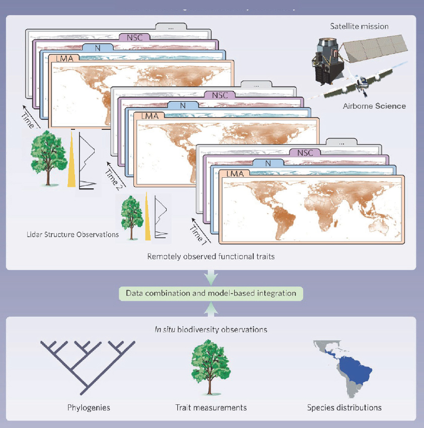
Recent powerful wildland fires have created internal weather conditions that caused hot and fast-moving fires, and others that injected dense smoke clouds into the lower stratosphere. Understanding these fires and the factors that cause them (addressing questions E-1a, E-1b, E-2a, E-3a, H-2a, and H-2b) requires co-locating optical, especially hyperspectral imagery, lidar, and multiband thermal imagery with concurrent air
sampling instruments in a DC-8-type flight environment. This will allow for comprehensive monitoring of poorly understood behavior of wildland fire and local fuel properties, rates of spread and distribution, fire radiative power, smoke particle density, and pollutant distribution type. Such information would revolutionize fire science and greatly enhance public safety and reduce wildland fire cost and risks. See also Section 4.2b for expanded discussion of an interdisciplinary approach to wildland fires.
NASA’s Plankton, Aerosol, Cloud, ocean Ecosystem (PACE;15Werdell et al., 2019) satellite and the EVI-5 Geosynchronous Littoral Imaging and Monitoring Radiometer16 instrument will be transformative for marine ecosystems when launched in the early 2020s but ongoing airborne research is required in preparation and will continue to be required during launch for Cal-Val. Similarly, NASA’s planned SBG mission and the European Space Agency’s Copernicus Hyperspectral Imaging Mission are expected to be transformative for understanding terrestrial ecosystems when they are launched in the later half of the 2020s.
Questions Best Addressed with Large Aircraft and Variables to Be Measured
Research addressing E-2 and E-3 questions are inherently interdisciplinary and have been explored during numerous missions to measure ecosystem-related carbon cycle chemistry. Studies such as the ARCTAS, SEAC4RS, and ATom represent a major use of the DC-8 and require this type of aircraft or one even larger. It is also a good example of research that crosses boundaries between traditional atmospheric science and ecosystems, demonstrating the need to consider co-location of instruments from multiple disciplines in some flight campaigns. It is under these types of objectives that ESAS ecosystem questions, especially E-2 and E-3, have had the greatest use of the DC-8 to date and have established requirements for research on the DC-8 or other large aircraft, through experiments on atmospheric chemical composition and its changes over space and time, particularly for carbon cycle molecules and aerosols. This larger application area has the greatest need (or near-term need) for heavy-lift, long-duration aircraft flying co-located sensors. Future research would benefit from including the ability to measure structural, compositional, and thermal characteristics of surface conditions concurrent with atmospheric chemical species. Ecosystem processes occur at scales from subseconds to millennia. Many physiological processes are temperature dependent and/or light dependent and consequently change rapidly (e.g., shifting sun/shade patterns) to diurnal processes that are hormonally controlled. Such short-term process-related changes make combining data from multiple aircraft challenging, one example of which is measuring chlorophyll fluorescence remotely (Aasen et al., 2019), while not having a negative impact on land cover classification studies. New
___________________
15 See https://pace.gsfc.nasa.gov/.
16 See https://eospso.nasa.gov/missions/geosynchronous-littoral-imaging-and-monitoring-radiometer-evi-5.
combinations of instruments that lead to development of methods, algorithms, or approaches to maximize scientific return will benefit ecosystem science and supporting research to address question E-1.
Much of the ecosystem research in recent years for both terrestrial and aquatic/marine ecology has focused on characterizing and detecting plant traits used to map plant (Dashti et al., 2019; Khanna et al., 2012; Roth et al., 2016) and algal communities (Kudela et al., 2015; Palacios et al., 2015), functional types (Schaaf et al., 2011; Schweiger et al., 2017; Ustin and Gamon, 2010), plant and algal species, and biodiversity (Féret and Asner, 2014; Khanna et al., 2018; Rocchini et al., 2018); or studies that relate to functional ecosystem processes (e.g., plant chemistry chlorophyll content or other pigments), water, nitrogen, and leaf mass area (Miraglio et al., 2020); and Leaf Area Index, a functional canopy trait in relation to carbon assimilation (Berger et al., 2020; Ferreira et al., 2018; Kokaly et al., 2009). Recently, efforts have focused on fusing genomics with remote sensing to monitor and predict biodiversity (Meireles et al., 2020; Yamasaki et al., 2017), which aligns with ESAS questions E-1, E-2, and E-3, and is now ready to expand to regional, continental, and global scales. Successful use of large aircraft to fly multiple instruments is needed to address the E-1 ecosystem research question but has not been demonstrated in the DC-8; however, the NASA ER-2, potentially capable of collecting data from four instrument pods, has been used. This aircraft has provided a large-scale subregional mapping capability for the ecosystem community that hosts several instruments in four pods, with flight durations of 10 hours and range of about 9,300 km (5,000 nmi). Other factors limit the versatility of the ER-2 and make it an expensive platform to operate, for example, limited ability to land in smaller airports, restrictions due to windspeed, fuel requirements, restricted flight hours for pilots, flight suit and gear requirements for the pilot, training requirements, significant maintenance, and the fact that the flight access is limited to the pilot.
There are newer science objectives identified in ESAS that will lead to greater demand for NASA’s large-capacity, heavy-lift, long-duration aircraft. This includes vegetation research in regions experiencing large, often climate-related, disasters such as droughts, floods, landslides, fires, and heatwaves. Aircraft deployment is needed to understand vegetation-ecosystem responses to earthquakes, tsunamis, volcanic eruptions, and contaminated sites (e.g., the BP Deepwater Horizon Oil Spill), regions with potential to switch states (such as ice to water) that have large carbon storage. It is also needed to address science objectives with societal impacts (Chen et al., 2020; Kokaly et al., 2013; Piégay et al., 2020; Tahsin et al., 2018).
The expanding scope of ecosystems research also recognizes interactions between terrestrial and aquatic/marine systems and the multifaceted interactions among disciplines. The three priority ecosystem questions in Table 4.4 illustrate the teleconnections between land, air, and water that require collaboration between previously separate scientific disciplines. This is reflected in the overlap between the ecosystem ESAS priorities and the objectives that cross other disciplines. For example,
the top questions in hydrology are related to vegetation type and function (see H-1 and H-2 in Table 4.1) where hydrological processes interact dynamically with vegetation, including ET, droughts, and floods. The tightly linked nexus between hydrology and ecosystems directly relates to the coupled water-energy-carbon-nutrients cycles and the climate-related radiative properties of carbon and water. Water use (ET) is a measure of plant function and has strong implication for agriculture and food security. ESAS questions related to weather (see Table 4.2 in this chapter and W-5 in Appendix D) explicitly identify weather impacts on the health of ecosystems and interacting processes that affect spatiotemporal structures of air pollutants. Geological hazards, atmospheric chemistry, sea level rise, and other priority areas of ESAS interact as well but are outside the scope of ESAS. Addressing these questions and their societal impacts will continue to expand the scope of airborne research in the ecosystems area, which will require more concurrent co-located multi-instrument datasets and collaborative multi-principal-investigator projects. It is likely that as ecosystem research advances, it will lead to requirements for measurements collected over larger distances and longer periods than past research. Requirements for many instruments making simultaneous measurements, including new technologies and instruments that measure ground conditions and concurrent atmospheric gas measurements, are also likely.
Conclusion 4.12. Interdisciplinary atmospheric chemistry/ecosystems research on carbon cycle, aerosols, and other pollutant molecules has had extended use of the DC-8 (e.g., ATom, ARCTAS, and SEAC4RS) and requires this or other aircraft with similar long-duration, heavy-lift capacity.
Conclusion 4.13. Future airborne research on ecosystems will incorporate multi-instrument deployments similar to the International Space Station suite (ECOSTRESS, GEDI, OCO-3, EMIT) or anticipated data fusion from free-flying SAR and hyperspectral imagers. Multi-instrument, multi-investigator deployments will require a DC-8-like heavy lift and size capacity, and some missions will likely require long duration. To add optical, thermal, lidar, or radar instruments to a payload such as ATom will require newer, smaller instruments to be accommodated, even on the DC-8 aircraft.
Conclusion 4.14. NASA ecosystems research related to high-priority ESAS questions have focused on regional-scale intensive field campaigns and use of multiple aircraft generally carrying single instruments. While these have largely avoided the need for a long-duration/heavy-lift aircraft, they have made integrating data from multiple aircraft difficult. Thus, a large aircraft capable of hosting multiple instruments making simultaneous measurements is needed.
Conclusion 4.15. The current configuration of single-instrument flights makes it difficult to address ecosystem dependences and interactions that could be detected using co-located multi-instrument platforms. Instrument incompatibilities make combining them on an aircraft like the DC-8 difficult, without rebuilding new instruments.
Conclusion 4.16. The ER-2 high-altitude aircraft provides a large-scale mapping capability hosting several instruments flown together, but with flight limitations compared to those of the DC-8.
Questions Well-Suited to Combinations of Smaller Aircraft
In addition to emerging needs for large aircraft, fundamental research will continue to involve individual and multiple principal investigator projects that are part of a coordinated NASA multiple-aircraft program such as ABoVE17 (Miller et al., 2019), where individual aircraft each carry one or a few sensors (e.g., ER-2). Some airborne measurements are best collected on separate flights due to measurement constraints. For instance, data collected with hyperspectral and multispectral optical instruments are easiest to process if repeat flights occur at the same sun-view angles. Optical instruments do not penetrate clouds (in contrast to radars), which constrains the conditions under which the data can be acquired. Lidars may need to be flown at lower altitudes and SARs at higher altitudes than other instruments to obtain best-quality data. Thus, separate smaller aircraft can provide flexibility for meeting program objectives.
Monitoring carbon sequestration and biomass may require data at scales from submeter to a few meters (Li et al., 2017; Neumann et al., 2012; Rignot et al., 1994; Tanase et al., 2014; Zolkos et al., 2013) and satellite data are too coarse spatially, while an aircraft flight, timed to site conditions, may be a better data acquisition plan. During disasters (floods, fires, tornadoes, hurricanes, pollution plume, explosion, etc.), there is a need for rapid response, for which an aircraft may be available sooner and acquire data at higher spatial resolution or different sun-view orientations than a satellite. Other questions may require subdaily interval measurements, such as monitoring crop or phytoplankton production, carbon assimilation, ET, or other physiological characteristics such as chlorophyll fluorescence. Satellite overpasses may be too infrequent or at the wrong time of day, while aircraft can be deployed to meet specific monitoring needs. Wildland fires typically have a diurnal pattern for peak rates of spread; thus, airborne monitoring at these times provides essential information for management. In marine systems, scheduling acquisitions may require timing to tides or to avoid sun glint, times when satellites may not be available.
New remote sensing trends include investigations characterizing components of biodiversity (Anderson, 2018; Cavender-Bares et al., 2020; Hooper et al., 2005; Jetz et al., 2019), the phylogenetic basis for canopy traits (Meireles et al., 2020), ecosystem trait assemblages for both terrestrial and marine ecosystems (He et al., 2019) as well as quantifying the composition of canopy traits, which include a wide range of biochemicals related to ecosystem functions such as photosynthesis or transpiration, for
___________________
which the three-dimensional structure of ecosystems (Saatchi et al., 2011) and canopy temperatures are needed to understand how changes in species composition affect changes in exchange of energy and matter between atmosphere, hydrosphere, geosphere, and biosphere. Such studies address the three most important ecosystem questions (E-1, E-2, E-3) in ESAS and require data from multiple instruments. These studies are at the testing and validation stage, especially in preparation for the launch of the SBG satellite. The ability to design an experiment to best match the scheduling requirements for flight orientation, time of day, and spatial scales of the study is complicated, as is coordination of multiple instruments on one aircraft. These requirements might make coordination of individual small aircraft better suited for some missions rather than using one large aircraft.
The newer emerging imaging technologies for addressing cutting-edge science (including the ESAS questions for ecosystems) are currently only available on aircraft, most flown by NASA (including Center programs, and principal investigator instruments, built under Earth Venture or Instrument Incubator programs). NASA currently flies several multispectral, hyperspectral, and thermal imagers for marine and terrestrial applications and specialized instruments such as for measuring chlorophyll fluorescence. NASA has C-, L-, and P-band SARs and lidar sensors for vegetation and ice structure. The NASA imaging instruments most widely used by ecosystem researchers have developed efficient, cost effective solutions that feature a one-instrument-per-platform model using small- to medium-size airborne platforms (Twin Otter, King Air, GIII, GV).
Role of Other Airborne Platforms
Small UAS have captured the interest of many ecologists. This is partly because the platforms can be under an individual investigator’s control so that access and timing of flights can better accommodate research goals, but also because flights are generally at low altitudes and the pixel sizes are small, making them ideal for testing remote sensing concepts and for scaling field data to larger airborne or satellite instruments at an intermediate scale. However, the small size also brings limitations in very short flight durations, and requirements for very small, lightweight instruments. Currently, various types of multiband visible-near-IR, hyperspectral visible-shortwave IR, thermal imagers, lidar scanners, instruments to measure air chemistry such as CO2, and other gas sensors, are flown on commonly used UAS platforms. These UAS lack the stability and control of larger, heavier instruments and produce data of lesser quality, including distortion in geolocation information. Because of the limited payload, UAS generally only carry one instrument at a time, for example, a four-band visible-near-IR imager. One main impediment to the wider use of airborne data (e.g., AVIRIS, AVIRIS-NG, and MASTER) by the ecosystem community is that poor georegistration requires extensive and time-consuming corrections prior to data analysis. Logistical limitations include uncertain and changing regulations for flight approvals in the United States and in international jurisdictions, including restricted access to sites (e.g., National Parks and protected areas
or other politically sensitive areas). There is a strong need to improve accuracy of georegistration, especially for high-spatial-resolution data, with more accurate in-flight high-frequency inertial navigation systems-GPS. Despite current limitations, the technology is in exponential adoption and will likely improve for research-grade applications as a consequence of the large market. A medium-class UAS that has potential for research is the Sensor Integrated Environmental Remote Research Aircraft (SIERRA-B), developed at NASA Ames Research Center, that can carry a 50 kg (110 lb) payload at 4 km (13,000 ft) for 8 hours.
Conclusion 4.17. Small UAS have limited scientific data quality capabilities today, but miniaturization of instruments and increased battery capacity will greatly increase applications in the future. Middle-size-class UAS, such as SIERRA-B, have potential for carrying multiple instruments, duration, and range but are underutilized today.
4.1e Sea level Rise in a Changing Climate and Coastal Impacts
Sea level rise was identified as a science priority and an integrating theme in ESAS, particularly because of its impacts on coastlines (e.g., McGranahan et al., 2007). Rapid increases in coastal flooding during tropical and winter storms due to sea level rise also occur. Sea level rise can be attributed to two leading factors: (1) ocean warming leading to thermal expansion; and (2) mass input to the ocean, largely as a result of ice sheet melting from Antarctica and Greenland, as illustrated in Figure 4.6. For the ice sheets,
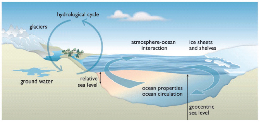
Table 4.5 2017 Earth Science and Applications from Space Decadal Survey Science and Applications Priorities for Sea Level Rise in a Changing Climate and Coastal Impacts
| Questions That Use Airborne Platforms | Measured Variables | Related ESAS Questions |
|---|---|---|
| C-1: How much will sea level rise, globally and regionally, over the next decade and beyond, and what will be the role of ice sheets and ocean heat storage? |
|
C-1a (MI) C-1b (MI) C-1c (MI) C-1d (VI) C-6a (VI) C-8b (VI) H-1c (MI) H-2b (I) |
| S-3: How will local sea level change along coastlines around the world in the next decade to century? |
|
S-3a (MI) S-3b (MI) S-4a (MI) H-1c (MI) H-2b (I) |
the key aspect is the mass balance, that is, the net gain in ice from solid precipitation versus net loss from melt, sublimation, surface water runoff, and glacier calving. Each of these areas can be investigated with observations and modeling, and satellite remote sensing instruments have been particularly useful in collecting data on these parameters (e.g., Joughin et al., 2010; Rignot et al., 2011; Tedesco and Fettweis, 2020; Velicogna et al., 2020). Airborne observations have also contributed critical information by filling gaps between satellite missions, facilitating calibration and intercalibration of satellite data, and providing targeted high-resolution simultaneous observations from several instruments.
Within the ESAS report, two science priorities, C-1 and S-3, focus specifically on sea level rise, including the impacts of ice sheet mass loss (Table 4.5). The causes and magnitude of sea level change will occur at various spatial scales, and impacts of sea level rise will manifest at the local scale and thus are particularly relevant to aircraft measurements.
These priorities and related questions outlined in ESAS have been and will continue to be addressed through satellite observations (e.g., the Jason series of radar altimeters, ICESat-2, and CryoSat-2), coupled with small aircraft observations including small-scale coastal lidar surveys and in situ measurements (e.g., tide gauges) for ground truth. However, larger aircraft also provide important capabilities to address these questions.
Questions Best Addressed with Large Aircraft and Variables to Be Measured
In addressing C-1, the most significant use of a large heavy-lift aircraft is to evaluate the contribution of ice sheets and glaciers to global sea level rise. This has been demonstrated previously through the OIB program (Studinger et al., 2010), which has evaluated sea level rise by surveying key variables over Greenland and Antarctica. The key parameters and instruments required to estimate them include ice sheet topography from laser and radar altimeters, snow depth from snow radars, ice velocity from SAR interferometry and optical imagery, gravity from gravimeters to evaluate changes in ice mass and to infer the underlying bathymetry, surface melt from optical and microwave sensors, and bare-Earth topography from penetrating radars. Ideally, these instruments are flown on a single aircraft for synchronous and spatially coincident observations. Although many parameters can be obtained by satellite, airborne platforms are necessary for the instrumentation to “see inside” the ice sheet—that is, using gravimeters and penetrating radars (e.g., Tinto et al., 2019). Much of the research focus is on understanding differences between drainage basins and geographically dispersed outlet glaciers (e.g., Sutterley et al., 2019). This work requires long-range aircraft that are able to survey a large range of remote areas of the Arctic and Antarctic. In the early phases of OIB, heavy lift was also needed to cluster the multiple large instruments on a single aircraft, and the DC-8 provided this capability. As the OIB program evolved, instrument packages became smaller (e.g., Arnold et al., 2019), and the program made use of a range of aircraft including the P-3, GV, DC-3, and Twin Otter. For example, the modularized IcePod instrument package, designed to be installed in any LC-130 aircraft, offered flexibility to OIB (e.g., Tian et al., 2020).
The Oceans Melting Greenland (OMG) project, which operated from 2015 to 2020, complemented OIB by collecting observations aimed at understanding the role of ocean circulation in bringing warm water into contact with tidewater glaciers and accelerating ice melt along the coast of Greenland (Willis et al., 2018). OMG made use of a combination of long-duration, high-altitude aircraft to fly gravimeters and small “low and slow” aircraft in order to launch airborne eXpendable Conductivity-Temperature-Depth probes to collect ocean temperature and salinity profiles at the glacier-ocean interface. The questions posed by OMG are equally applicable for Antarctica, which has led to similar projects around the Antarctic margins. The larger area and longer range required for Antarctic missions potentially could be filled by heavy-lift aircraft such as the DC-8 that would allow for more efficient and more complete observations.
A key component of sea level rise is the coastal topography. Airborne platforms can provide higher resolution and denser coverage in coastal areas than is available from satellite. This allows for the production of detailed local Digital Elevation Models (DEMs) that are important for assessing local sea level rise and its impacts. OIB has provided DEMs in polar regions, particularly of the Canadian Archipelago ice caps (Al-Ibadi et al., 2018) and the Greenland (Morlighem et al., 2014) and Antarctic ice sheets (Blake et al., 2010), as well as their basal topography (Morlighem et al., 2017). Numerous coastal DEMs have been produced by NASA, the National Oceanic and Atmospheric Administration (NOAA), and the U.S. Geological Survey from airborne instruments (Fredericks et al., 2016; Stockdonf et al., 2002). These missions have generally been local in nature using small aircraft. A longer-range aircraft such as the DC-8 would allow for more efficient mapping across a large area and would be able to reach more remote areas.
Weather and distance from major airports together make high-latitude operations challenging. In cold conditions ice can build up on aircraft, posing significant safety risks. Weather conditions can change suddenly and unpredictably. In addition, particularly in Antarctica, there are few runways, and safe landing conditions are not guaranteed. For this reason, most airborne missions over Antarctica originate outside of the continent (e.g., Chile, New Zealand). This means that a significant portion of the flight time is used for ferrying to and from the observational region, which requires safety margins sufficient to allow them to return to their point of origin. For these reasons, high-latitude investigations, such as OIB and OMG, continue to require long-range aircraft that can be scheduled to work around weather challenges. At present, these programs do not rely on heavy-lift capabilities, but as noted earlier, heavy-lift would potentially allow more complete and efficient data collection, particularly in the Antarctic.
Conclusion 4.18. A long-range aircraft is essential for understanding ice sheet dynamics and projecting future contributions of Antarctic and Greenland ice sheet melt to sea level rise. An aircraft with both heavy-lift and long-range capabilities is not currently essential but has potential utility in the future to allow coincident observations from myriad instruments, particularly over difficult-to-reach regions around Antarctica.
Questions Well-Suited to Combinations of Smaller Aircraft
Sea level rise research on both regional (S-3) and global (C-1) scales makes use of small aircraft in a number of ways that do not currently require a long-range, heavy-lift capability. The science questions identified in ESAS require measurement of a multitude of variables including ocean temperature and salinity as well as gravimetry and sea surface height. These can be addressed effectively through multiple-aircraft surveys because research programs have multiple objectives that can benefit from roughly coincident high-elevation flights and low-elevation operations. One example of this is
the OMG project’s aforementioned use of small, highly maneuverable aircraft to drop profiling ocean instruments in conjunction with long-range, high-altitude aircraft to complete surveys with radar interferometry to evaluate ice sheet elevation and with gravimetry to infer seafloor bathymetry (e.g., An et al., 2019; Willis et al., 2018; Yang et al., 2020). To meet these observational requirements, future programs are likely to continue to rely on high-elevation flights to survey large geographic regions in conjunction with low-elevation flights to safely deploy ocean-measuring instruments. OIB employed smaller aircraft for more limited survey regions, such as Alaskan glaciers.
Smaller aircraft have also been invaluable for mid-latitude research to address ESAS question S-3 on coastal impacts of sea level change. Airborne research on coastal sea level includes deploying sensors and surveying coastal topography, sea surface temperature, and sea state as part of process experiments. Water properties in coastal regions have been studied in part through the launch of expendable probes or profiling instruments, requiring dropsonde launch capabilities that are typically available on a C-130. Gravity, topography, and bathymetry surveys can be completed on long-range aircraft with comparatively light payloads such as a GV or P-3. Evaluations of coastal erosion are commonly carried out via airborne lidar surveys, ideally flown before and after major storms, typically at low tide.
Conclusion 4.19. As instrumentation has become lighter and smaller, more maneuverable aircraft have become advantageous for flexible data collection, particularly in narrow fjord regions of Greenland and Antarctica and local or regional mid-latitude coastal areas.
Role of Other Airborne Platforms
In recent years, oceanographers have made extensive use of ocean-based autonomous instruments, including profiling Argo floats, gliders, and autonomous underwater vehicles (e.g., AutoSub) to measure subsurface temperature and salinity over most oceans; however, the polar oceans present challenges due to the presence of sea ice and icebergs. Nonetheless, there have been several applications of such autonomous sensors in polar waters (e.g., Lee et al., 2017; Singh et al., 2017). Since water is impermeable to electromagnetic radiation, these in situ systems are critical for measuring the ocean interior, and they have the potential to be used more extensively in the future to understand both global and regional sea level rise and related questions, potentially with minimal reliance on aircraft.
UAS also have the potential to obtain valuable measurements, particularly of properties of the surface (e.g., sea surface temperature, wave state, ice cover) and atmospheric boundary layer, as well as coastal topograpy (e.g., Gonçalves and Henriques, 2015). One challenge for airborne surveys in the Arctic and Antarctic is that icing conditions and cloud cover can ground flights for days at a time. Like piloted operations, UAS have limitations in extreme cold temperatures and icing conditions that may limit their
capabilities. However, they offer some flexibility, such as being deployable from research ships as part of targeted process studies, which makes them particularly desirable for some surveys within the PBL (e.g., Bourassa et al., 2013). UAS have been successfully employed in the Polar Regions for several years for ice surface and atmospheric boundary layer observations (e.g., Cassano, 2014; Crocker et al., 2012).
Instrument development and technological advances over recent years have made UAS deployments more feasible (Arnold et al., 2019). A few high-latitude flights to measure laser altimetry were carried out using a long-range Global Hawk UAS (Blair and Hofton, 2015), and a snow radar was also tested for feasibility (Talasila, 2017). However, the Global Hawk was never made an operational component of OIB in part because it was not able to fly below the cloud deck. For polar environments, UAS that have longer range and larger payloads might be useful for sensors that can operate through clouds in order to be able to collect information over a fairly large region in all weather conditions (e.g., multiple outlet glaciers) from a single airstrip, thus simplifying logistics and reducing cost. Piloted aircraft, however, allow greater spontaneity to adapt flight plans in response to unexpected observations.
Additional Benefits to Earth System Science and Applications Activities for Airborne Platforms
Airborne platforms have broad capabilities that span a range of science questions that extend beyond the priority “most important” sea level rise questions identified in ESAS. Among these are research questions pertaining to ocean-atmosphere interaction. Aircraft have been used to test new sensors, including AirSWOT (Denbina et al., 2019); a Doppler Scatterometer (DopplerScat) to measure winds and currents (Rodríguez et al., 2018); and the Modular Aerial Sensing System (MASS), which includes a lidar, IR camera, and hyperspectral camera (Lenain and Melville, 2017). These instruments have direct links to satellite programs: AirSWOT and DopplerScat were conceived as airborne versions of instruments to be flown on satellites, and MASS has been tested as a part of the plan for SWOT Cal-Val. At the same time, they are part of current science experiments focused on understanding upper-ocean variability. In addition, OIB also included sea ice as a priority. The focus of the sea-ice flights was on sea-ice freeboard and thickness estimates and snow depth on sea ice in preparation for ICESat-2. Multispectral visible and thermal imagery was collected that is pertinent to surface fluxes (e.g., albedo, melt pond coverage, and temperature). A companion mission to OIB, ARISE (Smith et al., 2017), focused specifically on the summer radiation budget over sea ice; ARISE used the C-130 platform. Although a heavy-lift, long-range aircraft, such as the DC-8, is not currently required for these activities, the OIB experience has demonstrated the value of having the DC-8’s capabilities, particularly to fly multiple sensors concurrently that have not yet been miniaturized.
Conclusion 4.20. Airborne platforms provide a valuable complement to satellite missions and in situ observing networks by providing targeted coverage of key regions, such as rapidly changing glaciers and their interaction with the ocean, and vulnerable coastal areas where sea level rise impacts will be greatest.
Conclusion 4.21. For sea level rise research, airborne platforms have an important role in intercalibration of satellite instruments from different missions and potentially filling in gaps between satellite missions. While a heavy-lift, long-range aircraft is not currently required to investigate sea level rise, it has been invaluable in the past and could be invaluable for future multi-sensor measurement programs.
4.1f Surface Dynamics, Geological Hazards, and Disasters
Surface dynamics, geological hazards, and disasters are responses of Earth’s surface to tectonic, hydrological, ecological, and climatic processes and anthropogenic activities (NASEM, 2018a). These processes change on timescales of minutes to days up to decades or centuries, with local to larger impacts (Figure 4.7). Understanding the spatiotemporal characteristics of surface dynamics and their responses to natural and anthropogenic activities is fundamental to ensuring a sustainable future for Earth and informing societal responses. The study of these dynamic processes relies on remote sensing observations from satellites and airborne platforms as well as in situ measurements. Satellites provide global observations at relatively coarse spatial and temporal resolutions, while airborne sensors can offer local to regional measurements at finer spatial and temporal resolution. Satellite and airborne remote sensing observations together are key to understanding processes of rapidly changing landscapes and forecasting geological hazards and disasters.
The primary remote sensing instruments used to study Earth surface dynamics include InSAR, lidar, and optical multispectral and hyperspectral instruments. When SAR images are acquired at different times, the resulting InSAR images (i.e., repeat-pass InSAR) can map ground surface deformation. When two SAR images are acquired simultaneously, the InSAR images (i.e., single-pass InSAR) can be used to construct a digital surface model, whose elevations might lie between the bare-Earth and the canopy top over vegetated regions. Lidar can generate both bare-Earth elevation models and vegetation, snow, or ice canopy height. Surface deformation measurements from repeat-pass InSAR and bare-Earth elevation models from lidar are needed to address all of the surface dynamics, geological hazard, and disaster questions of the ESAS science and applications priorities (S-1, S-2, S-3, S-4, and S-6, Table 4.6). Optical sensors are used to capture landscape changes, particularly atmospheric contamination and volume, temperature, and composition of erupted volcanic products (S-2 and S-4).
All SAR, lidar, and optical data acquisitions require good attitude stability and accurate ephemeris and attitude knowledge of the platform. Repeat surveys require very accurate platform trajectory control (i.e., precision autopilot), which is a prerequisite for
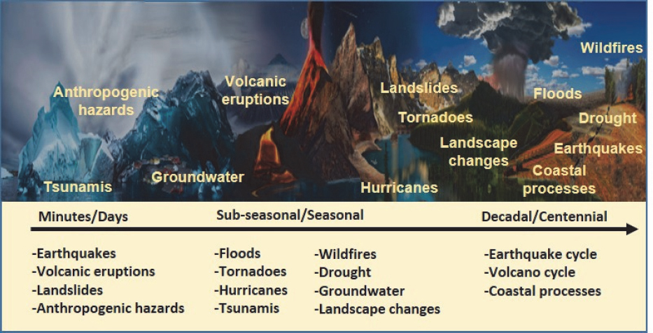
mapping surface deformation from repeat-pass InSAR. An imaging swath is generally proportional to the platform altitude, where a larger image swath requires higher platform altitude. SAR is essentially an all-weather side-looking sensor; its spatial resolution is independent of the platform altitude. Lidar and optical sensors are generally vertical viewing instruments and operate in cloud-free weather conditions; their spatial resolution is inversely proportional to the platform altitude. In addition, optical sensors only operate during daylight hours.
Airborne platforms can support investigation of the ESAS priority questions on Earth’s terrestrial surface dynamics, geological hazards, and disasters (Table 4.6). This section describes the variables with required spatial and temporal resolution and accuracy that need to be measured to address science questions and objectives.
Measuring surface deformation during the entire volcanic cycle of Earth’s active land volcano inventory with a timescale of days to weeks, and assessing surface deformation, volume, composition, temperature of volcanic products, and atmospheric contamination (e.g., CO2, CO, SO2, hydrogen sulfide, hydrogen, hydrogen chloride, hydrogen fluoride, and helium) during a volcanic eruption with a temporal sampling interval of hours to days are required to study volcanic activity and eruptions (S-1 and S-2).
Repeat-pass InSAR is required to capture surface deformation with an accuracy of 10 mm and spatial resolution of <100 m. Lidar, single-pass InSAR, and stereo-photogrammetry (including structure from motion) based on optical imagery can be
Table 4.6 2017 Earth Science and Applications from Space Decadal Survey Science and Applications Priorities for Surface Dynamics, Geological Hazards, and Disasters
| Questions That Use Airborne Platforms | Measured Variables | Related ESAS Questions |
|---|---|---|
| S-1: How can large-scale geological hazards be accurately forecast in a socially relevant time frame? |
|
S-1a (MI) S-1b (MI) S-1c (VI) |
| S-2: How do geological disasters directly impact the Earth system and society following an event? |
|
S-2a (MI) S-2b (VI) S-2c (VI) H-4a (VI) E-1d (I) |
| S-3: How will local sea level change along coastlines around the world in the next decade to century? |
|
S-3b (MI) |
| S-4: What processes and interactions determine the rates of landscape change? |
|
S-4a (MI) H-2a (VI) H-2b (I) H-2c(MI) |
| S-6: How much water is traveling deep underground and how does it affect geological processes and water supplies? |
|
S-6a (VI) H-3b (I) |
used to generate high-resolution Earth surface topography, and repeat surveys can map topographic changes and eruption products at an accuracy of tens of centimeters and spatial resolution of meters to submeters. Multispectral optical sensors are needed to detect the composition and quantity of the gases emitted prior to an eruption, and to measure the volume, composition, and temperature of eruption products (including height and gas and ash concentration of volcanic plumes) following an eruption (S-2).
Measuring surface deformation during the entire earthquake cycle, forecasting seismic activity over tectonically active areas on timescales of weeks to decades, and assessing co- and post-seismic ground deformation and damage to infrastructure following an earthquake with temporal sampling rates of hours to days are required to study seismic activity and earthquakes (S-1 and S-2). Repeat-pass InSAR is key to measuring the
deformation during and shortly after the earthquake with spatial resolution of 10-100 m (higher resolution near faults) and accuracy of 10 mm (per measurement). Lidar and optical images are also used to capture co-seismic topographic changes at spatial resolution of meters and vertical accuracy of submeters. The earthquake damage assessment maps can be obtained based on change detection processing of multitemporal SAR, lidar, and optical imagery at spatial resolution of meters. Repeat-pass InSAR is required to monitor interseismic deformation at spatial resolution of 100 m and accuracy of 1 mm/yr with weekly to monthly temporal sampling.
Landslide studies need monitoring of landslide movements, especially those near population centers at varying timescales. The required datasets are high-resolution bare-Earth topography at spatial resolution of about 10 m and accuracy of about 10 cm from lidar, and land surface deformation at spatial resolution of meters and accuracy of 10 mm (per measurement) and 1 mm/yr from repeat-pass InSAR (S-2). Weekly sampling of landslide movements from InSAR is needed to characterize the transient behaviors of landslides during the precipitation season. Vegetation and rock and soil types based on optical imagery at a spatial scale of about 10 m are needed to augment existing land cover or to map loss of vegetation cover (from logging, fires, extreme precipitation and severe storms, or earthquakes) that increases the probability of landslides and debris flows (S-2).
Determining vertical land motion along coastal zones is required to quantify the rates of sea level changes at monthly temporal frequency (S-3, Table 4.6). Repeat-pass InSAR is needed to measure vertical land motion driven by natural and anthropogenic processes including sediment compaction and erosion, adjustment of the solid Earth in response to changes in loading, extraction and injection of subsurface fluids, and tectonics. The required spatial resolution ranges from meters to kilometers and the accuracy should be approximately 1 mm/yr.
Quantifying global, decadal landscape changes produced by abrupt events and by continuous reshaping of Earth’s surface is required to study landscape changes due to terrestrial processes, tectonics, and anthropogenic activity (S-4). For example, loss of sea ice is resulting in stronger storms and coastal flooding and erosion in the Arctic, increasing disaster risk for communities in the region. Bare-Earth topography data from lidar, composition of Earth surface materials from hyperspectral optical images, and change detection based on SAR, lidar, and optical images are needed. The required spatial resolution ranges from centimeters to kilometers, and the temporal sampling varies from hours to years.
Determining the fluid pressures, storage, and hydraulic flow in confined aquifers, and the impact of water-related human activities and natural water flow on earthquakes needs land surface deformation measurement as a constraint (S-6). Repeat-pass InSAR is required for quantifying the land deformation associated with movement of fluids at a temporal frequency of weeks. The required spatial resolution is about 100 m and the required accuracy is 10 mm per measurement.
Remote sensing observations are required to rapidly capture the transient processes following disasters (e.g., volcanic eruptions, earthquakes, landslides, tornadoes, flooding, hurricanes, wildland fires) for improved hazard assessment and predictive modeling with temporal sampling of hours to days (S-1, S-2 and S-4; see also Section 4.2b). Optical and SAR images at spatial resolution of submeters to meters are needed to provide critical information on the magnitude and extent of damage in the affected areas. Repeated InSAR, lidar, and high-resolution optical data can provide information on both the magnitude of the ground deformation and the severity of ground damages. Multispectral optical data are especially valuable for monitoring the temperature, composition, and volume of erupted volcanic materials and atmospheric contaminants.
Questions Best Addressed with Large Aircraft and Variables to Be Measured
Large aircraft that are capable of stable and precise positioning and altitude, long range and duration, and accommodation of multiple sensors can be useful to understand geological processes. Although nearly all of the ESAS priority questions on surface dynamics, geological hazards, and disasters can be optimally addressed by smaller aircraft, the long-range capacity of a large aircraft that can host multiple sensors (e.g., SARs at several bands, lidar, and hyperspectral optical instruments) can enhance data collection over long distance and/or duration, improving efficiency and temporal sampling for interdisciplinary sciences.
Collecting lidar and optical remote sensing data over a large region in a short time frame can be efficiently accomplished with large aircraft. NASA's LVIS is a wide-swath imaging lidar that can map bare-Earth topography and the vegetation height with decimeter accuracy needed for many ESAS science investigations (S-1, S-2 and S-4). Although LVIS can be mounted into any aircraft equipped with a standard aerial camera mount and a window,18 collecting data over a large geographic scale is best done through long-range aircraft such as the DC-8. NASA’s Airborne Topographic Mapper (ATM) is a scanning lidar for constructing bare-Earth topography and the vegetation/snow/ice structure.19 It typically flies on aircraft at an altitude between 400 and 800 m AGL and measures topography to an accuracy of ~10 cm. The ATM instrument suite has collected high-precision topographic data from a wide variety of aircraft, including NASA’s P-3, DC-8, C-130, HU-25C and Twin Otters, to address ESAS science questions (S-1, S-2 and S-4). NASA’s AVIRIS is an optical sensor that collects hyperspectral data at 224 contiguous spectral bands with wavelengths ranging from 0.4 to 2.5 μm.20 AVIRIS has been flown on both large and small aircraft (e.g., ER-2, Twin Otter International's turboprop, Scaled
___________________
18 See https://lvis.gsfc.nasa.gov/Home/Platforms.html.
Composites' Proteus, and WB-57). AVIRIS allows for identifying and mapping surface materials needed to address ESAS science priorities S-2 and S-4.
Although the use of large aircraft has not been continuous since the AIRSAR (1988-2004; see AIRSAR discussions in sections 2.5d and 3.2), a long-range, heavy-lift platform could be ideal for collecting SAR, lidar, and optical remote sensing data for integrated scientific investigations over a large distance and could contribute to advancing all ESAS priority areas related to Earth surface dynamics, geological hazards, and disasters (Table 4.6). The long-range capacity of a large aircraft would enhance data collection over a long distance with high efficiency and better temporal sampling. For example, collecting repeat-pass InSAR over the entire 2,000-km-long Aleutian volcanic islands requires the capacity of a large, long-range aircraft.
Conclusion 4.22. For surface dynamics and geological hazards research, the long-range capacity of a large aircraft that could host multiple sensors (e.g., SARs of several bands, and/or lidar and optical instruments) could enhance data collection over a long distance and duration, improving efficiency and temporal sampling for interdisciplinary sciences, including this science area, over a large geographic scale.
Questions Well-Suited to Combinations of Smaller Aircraft
All of the ESAS priority areas on surface dynamics, geological hazards, and disasters can be addressed, and often optimally, using small aircraft. InSAR is a side-looking sensor and works in all-weather conditions while lidar and optical sensors are generally vertical looking and work only in cloud-free conditions. In most cases, data collected from all three types of instruments are needed to understand key geological processes, but because of this difference in sensor orientation and required flight conditions, data are best acquired from separate aircraft. Intelligent flight planning can be implemented to integrate observations from different sensors on separate but coordinated flights to allow optimization of aircraft capabilities for each of the sensors.
NASA’s UAVSAR21 flown on the GIII is designed to acquire either (1) repeat-pass polarimetric SAR and InSAR data at L-band or P-band for mapping ground surface deformation and soil moisture, or (2) single-pass InSAR at Ka-band for surface topography mapping. Over the past decade, NASA GIII aircraft have been the workhorse to collect SAR data to study surface dynamics and geological hazards and respond to disasters. Deformation measurements from UAVSAR can address ESAS science questions on a local or regional scale, including volcanic activity and eruptions (S-1 and S-2), seismic activities and earthquakes (S-1 and S-2), response to disasters (S-1 and S-2), landslides (S-2), coastal vertical motion (S-3), subsurface water flow (S-6), and landscape changes (S-4). Bare-Earth topographic data from LVIS and ATM from small aircraft can be used to address ESAS science objectives S-1, S-2, and S-4. Hyperspectral optical
___________________
imagery from AVIRIS or similar sensors is needed to answer ESAS science objectives S-2 and S-4.
One of the important usages of NASA’s smaller aircraft for Earth surface dynamics, geological hazards, and disasters is to acquire timely remote sensing observations for emergency responses (S1, S2, and S4). Responding to a geohazard requires platforms capable of rapid deployment and data acquisitions with frequent temporal sampling to enhance the evaluation of ongoing hazards and the predictive modeling of their evolution. Small airborne assets such as UAVSAR on GIIIs can be deployed quickly to collect data and provide timely information to improve scientific understanding and inform governmental authorities for combating the emergency.
Conclusion 4.23. Small aircraft will continue to be a key platform type in the study of surface dynamics and geological hazards and disaster response. Coordinated smaller aircraft, such as GIIIs, are the previously demonstrated and preferred aircraft because they optimize acquisition of SAR, lidar, and hyperspectral sensors requiring different imaging geometries, they can accommodate a range of weather conditions, and because rapid deployment and frequent temporal sampling are required for disaster responses.
Role of Other Airborne Platforms
Addressing future Earth system science questions requires multisensor observations at high spatial resolution, high temporal sampling, and improved measurement accuracy. In addition, rapid deployment of airborne sensors for urgent responses is essential for geohazard characterization and forecast. UAS combined with large and small aircraft will provide the maximum amount of flexibility in meeting ESAS goals (S-1, S-2, and S-4) and addressing future Earth system science questions of increasing complexity.
Measuring geological processes and responding to disasters requires observations that are often limited to small geographic areas. As traditional airborne campaigns provide important information on geological hazards and disasters, future measurements from UAS could also provide the required geographic coverage in many cases. New UAS and advanced technology balloons capable of operating in the stratosphere for extended periods have the potential to contribute to maintaining constant coverage over a region of interest for days to months. As instruments get smaller and lighter and UAS capabilities further develop, UAS could provide scientists with a fast response and required duration capability to supplement current aircraft activities (see Section 2.5). Finally, because rapid deployment and high temporal sampling are key requirements for disaster response, UAS measurements can be essential for capturing transient processes associated with geological disasters on timescales of hours and days, filling the data gap left by satellite observations.
Additional Benefits to Earth System Science and Applications Activities for Airborne Platforms
Airborne measurements serve as testbeds for future spaceborne sensors. NASA’s AIRSAR on board the DC-8 served as a NASA radar technology testbed for demonstrating new radar technology and the development of radar processing techniques for spaceborne missions. Instrumentation demonstrated by AIRSAR was flown as the SIR-C mission in 1994 and the Shuttle Radar Topography Mission (SRTM) in 2000. Similarly, NASA’s UAVSAR on GIIIs have been used to develop, validate, and improve new SAR technologies and algorithms for modeling geophysical phenomena for future Earth-observing satellite missions including SMAP, NASA-Indian Space Research Organization SAR, and SWOT. A range of platform attributes is essential for meeting NASA Earth system science observing objectives that are mission dependent. Some types of early sensor prototype and testing may only need a small platform with limited capability, while sensors that collect large or wide-ranging datasets or for which the prototype is large and power-intensive may require platforms with more extensive capability.
4.2 PROVIDING CAPACITY FOR EXPANDING FUTURE EARTH SYSTEM RESEARCH NEEDS
4.2a Integrating Themes in Earth System Science
For the science areas discussed in sections 4.1a-f, linkages emerged that point to successful campaigns and studies that brought together various disciplines. For instance, the DC3 and SEAC4RS missions are highlighted in both the Weather and Atmospheric Chemistry sections; ARCTAS and ATom are discussed in both the Ecosystem and Atmospheric Chemistry sections; and reference to FIREX-AQ in the Atmospheric Chemistry section specifically points to the use of MASTER for cross-disciplinary benefit. Other campaigns with strong multidisciplinary components include TC4, GRIP, NAMMA, NAAMES, and Convective Processes Experiment—Aerosols and Winds (CPEX-AW).
There is opportunity to build on and expand the interdisciplinary approach looking to the future to address ESAS questions. For each science area in Section 4.1, the committee identified ESAS questions that were related to the primary questions within that area but also questions from other areas. These linkages are presented in the third column of Tables 4.1 through 4.6 and demonstrate the highly interconnected nature of the Earth system and the need to cut across disciplines and science areas in order to fully address ESAS, as well as increasing knowledge about societal needs in a changing climate and rising seas. High-impact weather, climate, and geophysical extreme events are usually the results of complex interactions of various processes either within or among different components of the Earth system and they have high impacts on society as highlighted by the ESAS integrating themes.
4.2b Large Aircraft in Interdisciplinary Earth System Science
For more than 50 years, airborne observations have contributed substantially to advancing the understanding of the Earth system. This progress has occurred across a wide range of current Earth system science disciplines, as discussed throughout this chapter. Because components of the Earth system are so interconnected, approaches that span across disciplines are also essential. With increases in the observed changes in the Earth system and their linkages to societal well-being, the need for growth in interdisciplinary approaches in Earth system science will continue to grow, and there is a clear role for airborne platforms in that growth.
Improved understanding and more extensive observations of the Earth system are increasingly applied to societal and economic decision making. As this need expands and becomes more complex, Earth system observations and research must also advance to meet those needs. ESAS describes some needs of importance: managing air pollution risks, water quality, and food security; improving prediction of extreme weather such as severe storms, tornadoes, hurricanes, winter storms, and wildland fires; measuring the health and productivity of land and oceans globally; assessing risks from sea level rise; and predicting large-scale geological hazards and studying impacts of geological disasters on the Earth system and society (NASEM, 2018a). All of these societally relevant issues rely on interdisciplinary integrated Earth system science research strategies that include airborne science.
The ESAS committee recognized that these types of issues extend beyond disciplines and the interdisciplinary study panels that were the focus of the survey and developed integrating themes to foster discussion across panels. Some of these themes, including the water and energy cycle and sea level rise, are key science and applications areas of ESAS and have been discussed at length in this chapter. Others, including extreme events, the carbon cycle, tipping points, and human health, have not been addressed directly. It is beyond the scope of this committee’s charge to comprehensively evaluate the need for a large aircraft to identify new interdisciplinary research questions that may link to the integrating themes or Earth system science more broadly within NASA and other U.S. agencies. However, the committee sees opportunities for a large aircraft to provide important capabilities to address integrating themes and interdisciplinary Earth system science research more broadly.
Complex problems require an integrated Earth system science observing system (Figure 2.1) including satellite and surface-based observations, and targeted observations by aircraft carrying instruments based on existing and emerging technologies. Much like within the science areas discussed earlier in this chapter, there are some cases where interdisciplinary research can be conducted without a large aircraft. Small aircraft and UAS are critical for meeting interdisciplinary, societally relevant needs, particularly when science questions do not require co-located, simultaneous observations, such as of mudslides occurring after extreme precipitation on land that has burned; pre- and post--
tropical cyclone landfall land conditions and flooding; and when aircraft need to be deployed quickly to observe conditions as natural disasters transpire.
Extreme events are often a result of the occurrence of a series of linked events from different components of the Earth system happening over a wide range of temporal scales. For example, landslides can be caused by extreme rainfall over just minutes to hours, yet the conditions leading to the instability may develop over thousands of years as the landscapes evolve, or they can result from a recent disturbance such as deforestation that reduces the strength of the soil. However, in other instances where equipment is large and/or when suites of measurements must be collected simultaneously to address the research questions, a large aircraft provides unique capabilities that may transform understanding in new ways as we look to the coming decade and beyond.
There are also recent scientific advances, field campaigns, and emerging technologies that demonstrate how a large aircraft will enable science to advance interdisciplinary research beyond its current application. This section explores two types of extreme events for which interdisciplinary research is critical—wildland fires and extreme precipitation and flooding—and evaluates where a large aircraft is required to advance the science. These examples are not intended to be prescriptive of future research agendas or individual campaigns but instead to demonstrate the interdisciplinary nature of the research areas and those for which a large aircraft would provide unique value.
The Interdisciplinary Challenge of Extreme Precipitation and Flooding
Climate change has increased the frequency and intensity of extreme precipitation and associated flooding events in recent years (e.g., Madsen et al., 2014). As surface temperature increases, early spring snowmelt and increased streamflow have also contributed to a growing number of flooding events. These changes link to many science areas discussed in this report including physics and dynamics for improving weather forecasts; ecosystem change—land and ocean; sea level rise in a changing climate and coastal impacts; and surface dynamics, geological hazards, and disasters.
Extreme rainfall associated with landfalling tropical cyclones and winter storms affect marine and land ecosystem changes across coastal zones. Coastal and inland flooding has become one of the highest risk factors for coastal communities in a changing climate and rising seas worldwide; these events cause the majority of landslides. Rapid intensification of hurricanes and storms, and near-surface properties, including at the PBL and upper ocean, are difficult to observe from space. Therefore, a combination of airborne observations typically used in individual disciplines is necessary to better understand and predict these complex phenomena.
Extreme rainfall is an important trigger causing both runaway and slow-moving landslide events in regions with steep terrain. Slope failures are heavily mediated by the
hydrological conditions due to precipitation over seasonal timescales, via increased pore-water pressure and the attendant reduction in effective normal stress along basal shear zones. Therefore, monitoring ground movement over landslide-prone regions during and after extreme rainfall events is important to predict landslide failures and the associated hazards. Repeated SAR images from aircraft observations, as discussed in Section 4.1f, allow for monitoring of landslide movement on timescales of hours to days, filling the gaps of observations from space. In addition, high-resolution airborne remote sensing images provide accurate delineation of runouts of landslides and the associated landslide changes and flooding.
Aircraft observations have played a unique and critical role in observing tropical cyclones over the open ocean and coastal regions. In most cases, aircraft are the only viable type of platform to take measurements inside the hurricanes and storm environment. These observations have contributed to our understanding of hurricane dynamics and improving hurricane forecasts with increased lead time over the past several decades. The DC-8 has been used in many field campaigns observing tropical cyclones because it can carry the multiple instruments required for the research over long distances. These campaigns include TOGA COARE (1992-1993), CAMEX-2/3/4 (1998-2000), NAMMA (2006), GRIP (2010), and CPEX (2017). Recent developments of the airborne wind Doppler Aerosol WiNd lidar and the Airborne Third Generation Precipitation Radar with ka-, ku-, and W-band capabilities, together with the German High Altitude and Long Range Research Aircraft and the High Altitude Monolithic Microwave Integrated Circuit Sounding Radiometer, have made significant progress toward observing cloud, microphysics, temperature, humidity, and wind in tropical cyclones (Figure 4.8) (Mazza and Chen, 2021). The needs for co-located, simultaneous measurements using multiple radars and lidars require a large aircraft with payload capability similar to that of the DC-8.
Another critical need for observing tropical cyclones and other high-impact weather like atmospheric rivers over the ocean is long-duration flights beyond 10-12 hours. It often takes ferry times of 4-6 hours (to and from the storms), plus at least 5-6 hours of observation time in the storm. These characteristics become even more important for making integrated observations of the atmosphere, ocean, and land surface for flooding.
One of the grand challenges in predicting landfalling tropical cyclones is the rapid intensification when the upper ocean conditions and air–sea interaction are most critical but difficult to observe. Field campaigns such as Coupled Boundary Layers and Air-Sea Transfer (CBLAST) in 2003-2004 (Black et al., 2007; Chen et al., 2007) and Impacts of Typhoons on the Ocean in the Pacific (ITOP) in 2010 (D'Asaro et al., 2014) have demonstrated the importance of fully coupled atmosphere-wave-ocean observations
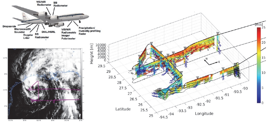
using heavy-lift aircraft like the C-130 and P-3 that can penetrate heavy precipitation and target features in the upper ocean. This interdisciplinary approach proved to be most effective in collecting measurements in the atmosphere and the ocean in hurricanes (Figure 4.9). In particular, scanning precipitation radars on board NOAA P-3s prove to be critical, which can enable targeted observations of atmospheric and oceanic features that may otherwise be prohibitive in heavy rain and convective conditions.
It is critical to have co-located observations from multifrequency radars, lidars, and air-deployed in situ measurements including GPS dropsonde, UAS, and ocean drifters and floats. Some emerging technologies using multiple aircraft and air-deployed UAS that take in situ measurements extend sampling into the PBL and have been tested in recent field campaigns (see Section 2.5c).
Flooding from landfalling tropical cyclones is usually caused by a combination of extreme rainfall, storm surge, and land surface properties as shown during Hurricanes Harvey (2017) and Laura (2020). Sea level rise due to climate change will continue to increase the risk of coastal and inland flooding. In addition to observing the atmospheric and ocean conditions in hurricanes and the storm environment, aircraft measurements of the land surface conditions prior to, during, and after storms will be needed for better understanding and prediction, as well as decision making.
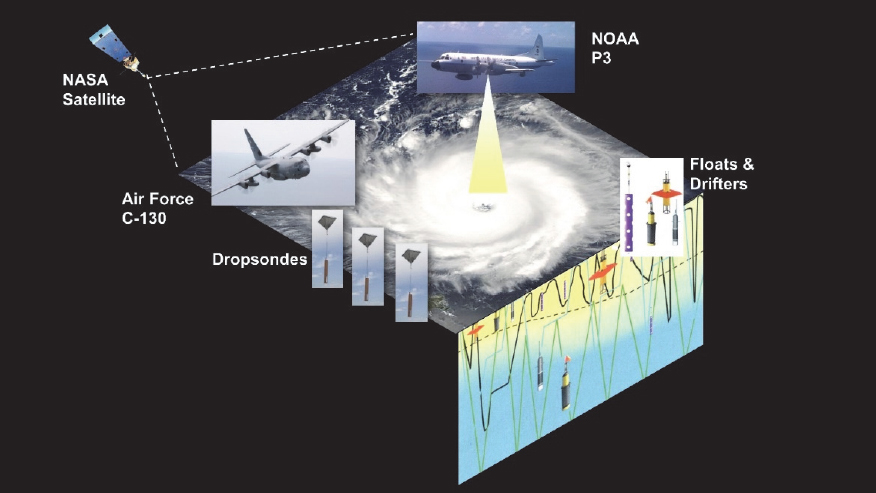
Future research in high-impact weather systems such as hurricanes requires an aircraft with the following characteristics:
- Long duration of approximately 10-12 hours;
- Wide range of altitude capability, up to 12-15 km;
- Robust airframe that can fly safely in icing and turbulent conditions;
- Payload capable of handling radars, lidars, air-deployed dropsondes, ocean drifters and floats, and UAS; and
- Scanning precipitation radars that enable targeted observations in heavy precipitation and high wind conditions.
A large aircraft with such capabilities is uniquely suited for observing high-impact weather systems such as hurricanes and winter storms whereas spaceborne and surface-based platforms are limited in multifaceted, co-located in situ and remote sensing measurements and mobility, respectively. Without a large aircraft such as the DC-8, the existing capability of observing high-impact weather will be severely
compromised, and also the potential for innovative and transformative interdisciplinary research with multi-instrument and air deployables across the interfaces of the Earth system components to meet emerging societal needs for better observing and predicting weather, climate, and geological hazards will be diminished.
The Interdisciplinary Challenge of Wildland Fires
Wildland fires interact with the atmosphere and land surface (vegetation and soil moisture) over a wide range of timescales (Figure 4.10). Fire–atmosphere interactions include the development of convective plumes, fire-induced inflow winds, and smoke-radiative effects (Potter, 2012). Wind, humidity, and thunderstorms can influence fire initiation and spread, which endanger community safety and properties. Wildland fire plumes affect air quality over local, regional, and continental scales, depending on the vertical and horizontal transport of the smoke and aerosol, from minutes to weeks. Multiyear droughts, snowpack from the previous winter, and precipitation during the spring can affect wildland fire on longer timescales. Post-fire burned land surface is prone to landslides especially over the West Coast regions.
Recent field campaigns have aimed to address the complexities of wildland fire using aircraft, satellite, and surface-based observations. The Rapid Deployments to Wildfires Experiment (RaDFIRE 2013-2016) focused on fire–atmosphere interaction with aircraft and mobile profiling systems (Clements et al., 2018) while the FIREX-AQ campaign in 2019 combined near- and far-field observations to understand emissions, chemical evolution, and transport, and evaluated downwind impacts of wildland fires.
Wildland fires release substantial amounts of pollutants into the atmosphere (Andreae, 2019; Crutzen and Andreae, 1990; Yokelson et al., 2008). These pollutants include nitrogen oxides, other nitrogen-containing compounds, CO2, CO, hundreds of different VOCs, and smoke particles. The exact mixture depends on the vegetation being burned and the environmental conditions that affect the fire intensity. Winds and weather spread these pollutants, concentrating them near the surface in nearby regions, affecting both regional ecology and human infrastructure, as well as dispersing them over thousands of miles, degrading the air quality for tens of millions of people.
As the smoke plumes move and disperse over hours to days, the chemistry in them evolves and new pollutants emerge. Most of the larger smoke particles fall out in regions downwind of the fires. However, ozone is formed from reactions involving the nitrogen oxides and many larger VOCs age and condense on existing particles or form new, small particles, which are particularly hazardous to human health. Thus, wildland fires create an atmospheric chemical mixture that is as complex and potentially hazardous as that found in heavily polluted urban environments.
The wildland fire smoke chemical composition has several effects. Several of the emitted gases are classified as hazardous air pollutants by the U.S. Environmental
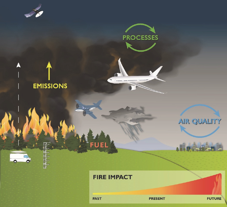
Protection Agency, which, along with the smoke particles, harm human health (O’Dell et al., 2020). Many of these pollutants, such as CO2 and particles, affect climate. Also, deposition of smoke constituents alters the regional carbon and nitrogen balance in and near the fire areas.
Many dimensions of the wildland fire challenge require interdisciplinary research that links climate change, ecosystem change (short- and long-term) and emissions, weather, hydrology (e.g., soil moisture, changes in surface runoff pre- and post-fire), and atmospheric chemistry and composition and air quality. These topics cut across the science areas discussed in Section 4.1 including coupling of the water and energy cycles;
air quality and atmospheric chemistry—chemistry coupled to dynamics; ecosystem change—land and ocean; and surface dynamics, geological hazards, and disasters.
A heavy-lift aircraft is needed to make coherent, co-located, simultaneous measurements using Doppler radar and lidar and have a PBL and troposphere profiling system for co-located sampling of plume kinematics and microphysical properties. These types of measurements may provide insight for future aircraft-based observations of wildland fire pyroconvective processes and fire–atmosphere interaction (Clements et al., 2018). Fire-induced cumulonimbus can bring material from the PBL into the middle stratosphere (up to 25-35 km). Long duration is also important for observing regional and mesoscale wind and moisture fields which determine how rapid fires spread (Mass and Ovens, 2019). Recent studies show that these plumes can alter radiative forcing and dynamic circulation across large regions. However, the role of pyrocumulonimbus activity in the climate system is still unclear. Ongoing research on this topic fits multiple scientific disciplines, such as atmospheric chemistry, cloud dynamics and microphysics, fire dynamics, radiation, and interaction with weather conditions. The first detailed in situ dataset from within the high-altitude outflow region of a pyrocumulonimbus was collected using the DC-8 during FIREX-AQ in 2019. A large aircraft is required for future observations of these unique fire-induced storms and the ensuing high-altitude smoke plumes as well their transport (e.g., Khaykin et al., 2020).
Smoke and aerosol can affect surface temperature and vertical atmospheric temperature profiles. The properties of the surface and PBL are important for both fire–atmosphere interaction (as demonstrated during RaDFIRE) and transport of smoke and pollutants. This requires observations of the PBL near the fire locations as well as the mesoscale–synoptic scale environment. The surface-based mobile profiling system deployed in RaDFIRE was limited by its speed and areal coverage. Co-located measurements from aircraft of atmospheric profiles of temperature, humidity, wind, aerosol, and chemistry are better suited for sampling these vertical profiles.
Understanding the chemical composition of primary and secondary pollutants from fires and thus being able to predict the ecological and human impacts of fire requires measuring the atmospheric chemical composition and environmental conditions in the smoke plumes. Measurements must include gas-phase chemical species such as CO2 and CO, nitrogen oxides, ozone, and at least dozens of the many fresh and aged VOCs. Also essential are measurements of particle number, concentration, size, chemical composition, and other particle properties. A number of instruments are required to make these measurements. Because smoke plumes are not well mixed and are constantly evolving, the measurements must be made simultaneously in time and space. A large aircraft is the only airborne platform capable of making these multiple simultaneous measurements.
Conclusion 4.24. A large aircraft can help to better observe multiple components of the Earth system that are critical for understanding, prediction, and decision making
to address emerging societal needs such as coastal flooding in a changing climate and rising seas.
Conclusion 4.25. Broad support for interdisciplinary research using a large aircraft along with innovative approaches using multiple aircraft and emerging technology such as air-deployed UAS can lead to transformative outcomes in advancing Earth system science for the benefit of society.
Conclusion 4.26. A large aircraft will be critical, along with satellite and surface-based observations, for advancing scientific understanding and also informing the next-generation of coupled fire–atmosphere–chemistry with interactive land surface models. This will facilitate the development of new tools for improving fire and air quality forecasts, fire management, and public safety and health.
Conclusion 4.27. Smaller aircraft and UAS are also critical for meeting interdisciplinary, societally-relevant needs, particularly when science questions do not require co-located, simultaneous observations, such as mudslides occurring after extreme precipitation on land that has burned; pre- and post-tropical cyclone landfall land conditions and flooding; and when aircraft need to be deployed quickly to observe conditions as natural disasters transpire.
4.2c Providing Capacity for the Unexpected
Thoughtful and informed decadal surveys and research agendas may lay the groundwork for the evolution of Earth system science research, but new discoveries and unexpected events also influence the science that is conducted. Many of the events or processes discovered have had serious detrimental effects on human health, societies, and economies, thus increasing the urgency of performing the research necessary to understand them. While these situations may be impossible to predict and completely prepare for, having the necessary tools and platforms available provides a high degree of flexibility to address complex, interdisciplinary questions and can enable relatively nimble responses when surprises occur.
An example of an environmental surprise is the discovery of the Antarctic ozone hole, which was first documented by the British Antarctic Survey group in 1985 (Farman et al., 1985). No existing theory or model of dynamics or of chemistry could explain this dramatic stratospheric ozone loss. Several dynamical and chemical hypotheses were quickly devised, but testing them required an integrated strategy including observations from satellites, aircraft, and the surface, all coupled to computer models, as well as controlled laboratory studies. Antarctic ground-based remote sensing measurements in 1986 generally ruled out dynamical causes and implicated chlorine from chlorofluorocarbons (Solomon, 1987), but the definitive evidence of extreme levels of reactive chlorine causing the rapid ozone loss came from airborne NASA ER-2 and DC-8 observations in 1987 (Watson et al., 1989). Had these aircraft and several instruments
not been available to make these critical observations, years could have elapsed before enough evidence was accumulated to convince governments to agree to the Montreal Protocol on Substances that Deplete the Ozone Layer and its amendments, thus worsening global ozone layer loss and delaying stratospheric ozone recovery.
Conclusion 4.28. Having airborne research capability provided by a large aircraft is critical for meeting the unanticipated future Earth system science research needs.


