
3
U.S. Department and Agencies Roles and Current and Planned Capabilities
Numerous departments and agencies of the federal government have responsibilities related to making a “space-weather ready” nation.1 This chapter, based on workshop presentations and discussions,2 focuses on those federal departments and agencies that have a major role in space weather–related research and operations, with particular attention to agency roles, current capabilities, and potential future capabilities. Speakers from the departments and agencies included the following:
- Tamara Dickinson, Science Matters Consulting, LLC, Session Chair
- Elsayed Talaat, National Oceanic and Atmospheric Administration (NOAA) National Environmental Satellite, Data, and Information Services (NESDIS)
- Jim Spann, National Aeronautics and Space Administration (NASA) Heliophysics Division (HPD)
- Mike Wiltberger, National Science Foundation (NSF), Division of Atmospheric and Geospace Sciences (GEO/AGS), Geospace Section (GS)
- Rachel Hock-Mysliwiec, U.S. Air Force, Air Force Research Laboratory
- Steve Volz, NOAA NESDIS
- Lt Col Omar A. Nava, U.S. Air Force, Air Force Weather
- Jonathan Margolis Turner, Department of State
___________________
1 A space-weather ready nation would be analogous to a weather-ready nation—resilient to extreme weather, water, and climate events—that is part of the strategic vision of NOAA’s National Weather Service. See L.W. Uccellini and J.E. Ten Hoeve, 2019, “Evolving the National Weather Service to Build a Weather-Ready Nation: Connecting Observations, Forecasts, and Warnings to Decision-Makers through Impact-Based Decision Support Services,” Bulletin of the American Meteorological Society 100(10): 1923–1942.
2 Links to presentations can be found at https://www.nationalacademies.org/spacewx-phaseI-presentations.
NOAA CURRENT CAPABILITIES
NOAA is the nation’s official source of real-time space weather monitoring for the government, and commercial sectors, exclusive of the Department of Defense (DoD). The agency is also responsible for observations in support of space weather operations; continuous improvement of operational space weather services; and utilizing partnerships, as appropriate, with the research community—including academia and the private sector, and relevant agencies—to develop, validate, test, and transition space weather observation platforms and models from research to operations (R2O) and from operations to research (O2R).3
Central to NOAA’s space weather responsibilities is its Space Weather Prediction Center (SWPC) in Boulder, Colorado, the nation’s official source for space weather alerts, watches, and warnings. SWPC is one of nine National Centers for Environmental Prediction (NCEPs) of the National Weather Service and coordinates its activities, products, and services daily with its DoD counterpart, the 557th Weather Wing, located at Offutt Air Force Base, in Bellevue, Nebraska.
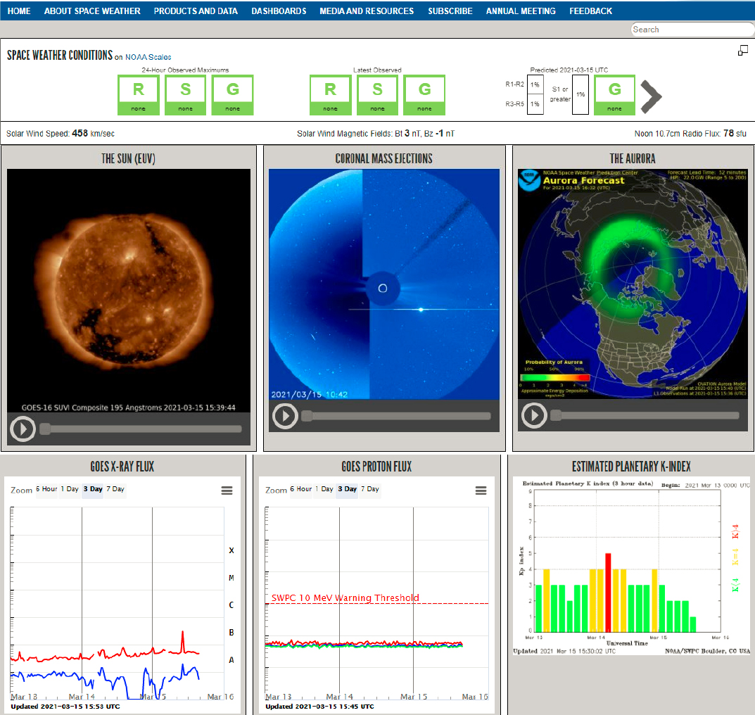
SWPC delivers a diverse range of products and services that cover space weather conditions on the Sun, in interplanetary space, and at Earth, all continually updated and displayed on the SWPC homepage (a screenshot is shown in Figure 3.1). The products are largely data driven and are aimed at a broad range of user groups. The information is presented in both text and graphical form using the NOAA space weather scales for geomagnetic storms, solar radiation storms, and radio blackouts as well as other indices and parameters. The primary means for product distribution include an email product subscription service with over 58,000 subscribers. SWPC also provides access to a multitude of real-time space weather measurements used directly by end users or by commercial service providers to produce value-added products for end users.
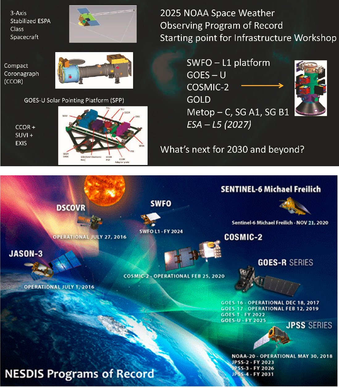
Observational needs and requirements are set by SWPC and fulfilled by NOAA NESDIS, other federal agencies, and international partners. NESDIS operates the nation’s weather satellites and acquires the next-generation Earth and space weather observation satellites. The Space Weather Follow-on (SWFO) is one of the major development programs in NESDIS and is part of an effort to establish an integrated space weather observing system out to 2030. NOAA conducted a NOAA Satellite Observing System Architecture (NSOSA) analysis to focus on high-value options across the portfolio, including a mix of observations and new business models. The NOAA Space Weather Program is building on the NSOSA findings. The next-generation program will provide real-time imagery and in situ space weather measurements, new data to revolutionize space weather forecast models, and accurate, timely, and high-reliability warning of geomagnetic storm events. NESDIS is analyzing concepts recommended by NSOSA, including spacecraft in either geostationary orbit (GEO) or Tundra (over the Arctic) orbit, space weather satellites rideshares to GEO or L1, hosting instruments on commercial satellites, and partner instruments on NOAA satellites.
NOAA has also been conducting a pilot commercial weather data program (CWDP) for the purchase of GNSS (Global Navigation Satellite System) radio occultation data, with the SWPC evaluating these and additional commercial data sets for possible operational use. These actions are already in keeping with the PROSWIFT Act, which establishes a permanent CWDP for space weather within NOAA.
NOAA’s current space-based observational needs require an architecture in which specific instruments are placed on platforms in a variety of orbits. These include the following:
- Low Earth orbit (LEO) is usually defined as altitudes below 1,000 km where many communication, navigation, and surveillance satellites fly. In situ measurements of energetic ion and electron flux have been provided by instruments on NOAA’s Polar-orbiting Environmental Satellites (POES)
___________________
3 Executive Order, 2016, “Coordinating Efforts to Prepare the Nation for Space Weather Events,” October 13, https://obamawhitehouse.archives.gov/the-press-office/2016/10/13/executive-order-coordinating-efforts-preparenation-space-weather-events.
- and similarly instrumented MetOp spacecraft,4 with the previously mentioned commercial GNSS radio occultation measurements providing total electron content to characterize the current state of ionosphere. Replaced by the Joint Polar Satellite System (JPSS)—the first of which launched in 2017 and is now identified as NOAA-20—these polar-orbiting spacecraft are designed principally for monitoring terrestrial weather and no longer carry instruments to make energetic charged particle measurements. MetOp spacecraft will continue to measure >20 keV electrons, which can pose a spacecraft surface and deep dielectric charging hazard, but will not measure electrons in the
___________________
4 European Organisation for the Exploitation of Meteorological Satellites (EUMETSAT), 2020, “Operating Satellites,” https://www.eumetsat.int/what-we-do/operating-satellites.
- 0.5-20 keV range. These were measured by earlier generation POES spacecraft and are responsible for most of ionospheric conductivity exclusive of solar ultraviolet ionization.
- Geostationary Operational Environmental Satellite (GOES) is near-equatorial orbit, at ~6.6 Earth radii from Earth’s center, typically residing in the outer magnetosphere, although it can extend into the solar wind on the dayside if the magnetosphere is compressed during disturbed solar wind conditions. In situ measurements of the local space environment at this location, including energetic particle radiation fluxes and the magnetic fields, respectively, provide advanced warnings and current state. Imaging of the Sun’s state and activity in the X-ray and ultraviolet bands provides a 1- to 4-day advanced warning of geomagnetic storms. The current GOES(-R) series of spacecraft hosts the Solar Ultraviolet Imager (SUVI) to observe and characterize complex active regions of the Sun, solar flares, and eruptions of solar filaments, which may give rise to coronal mass ejections (CMEs), and the Extreme Ultraviolet and X-ray Irradiance Sensors (EXIS), which detects solar flares and monitors solar irradiance impacting the upper atmosphere. The two instruments that measure the space environment include the Space Environment In-Situ Suite (SEISS) to monitor proton, electron, and heavy ion fluxes in the outer magnetosphere and the magnetometer to provide situational awareness.
- L1 (Deep Space Climate Observatory [DSCOVR] spacecraft) is a Lagrange point about 1.5 million km upstream of Earth. It provides a stable orbiting location for monitoring the properties of the solar wind and interplanetary magnetic field, as well as energetic particles, which are destined to impact Earth’s magnetosphere. In situ measurement of the solar wind speed and magnetic field provides 15-60 minutes of advanced warning of the time of onset and the likely intensity of geomagnetic storm conditions at Earth. Coronagraph imaging of the Sun for CMEs, combined with modeling, provides a 1- to 4-day advanced warning of geomagnetic storms, but with much lower accuracy (+/− 9 hours) than the more immediate warnings from in situ instruments.
DSCOVR was launched on February 11, 2015, to provide real-time solar wind monitoring for NOAA, a role previously assumed by NASA’s Advanced Composition Explorer (ACE). DSCOVR has two space weather instruments: Solar Wind Plasma Sensor (Faraday Cup) and Magnetometer (PlasMag). These instruments measure solar wind velocity distribution and the magnitude and direction of the solar wind magnetic field to provide rapid warning of geomagnetic storms. However, DSCOVR did not include coronagraph and, until the launch of SWFO-L1, the nation will need to rely on the now over-25-year-old SOHO spacecraft to monitor CMEs.
NOAA’s anticipated program of record (Figure 3.2), which is the starting point for this workshop, includes SWFO-L1, GOES- East, GOES-West (with a coronagraph, CCOR1), Cosmic 2—a joint 6-satellite low-altitude radio occultation program with Taiwan, and the NASA Global-scale Observations of the Limb and Disk (GOLD) mission described below. In addition, NOAA plans to leverage NASA and DoD capabilities. NOAA can also leverage the resources of its international partners; for example, the mid-decade program of record is expected to include the ESA (European Space Agency) and EUMETSAT’s (European Organisation for the Exploitation of Meteorological Satellites’) MetOp-SG (Meteorological Operational-Second Generation) polar-orbiting operational meteorological satellite system.5 Other
___________________
5 Note added in proof: On November 20, 2020, NOAA awarded its first contracts to purchase commercially available space-based radio occultation (RO) data for use in NOAA’s operational weather forecasts. The 2-year Indefinite Delivery Indefinite Quantity (IDIQ) contracts with a total contract ceiling of $23 million, went to the U.S. commercial space firms GeoOptics and Spire Global. Under the overall IDIQ contracts, NOAA also awarded initial delivery orders for this RO data to both companies. Subsequent delivery orders will be released throughout the 2-year contract period at NOAA’s discretion. See NOAA, 2020, “NOAA Awards First Commercial RO Contracts Supporting Operational Weather Forecasting,” Office of Space Commerce, November 20, https://www.space.commerce.gov/noaa-awards-first-commercial-ro-contracts-supporting-operational-weather-forecasting/.
opportunities will come from leveraging various cooperative agreements and partnerships with, among others, Taiwan’s National Space Organisation (NSPO), the Korean Meteorological Administration (KMA), the Japan Aerospace Exploration Agency (JAXA), the Centre National d’Études Spatiales (French Space Agency), the Canadian Space Agency (CSA), and the Indian Space Agency (ISRO).
NASA consistently plays key supporting roles in space weather monitoring and forecasting, with ongoing relationships of several of its research and exploration programs to NOAA’s and SWPC’s goals. NASA HPD leads several research programs dedicated to the understanding of the Sun and its interactions with Earth and the solar system. In addition to missions and projects that explore aspects of the physics of the coupled space weather system, it seeks to advance space weather modeling and prediction capabilities through programs such as Living With a Star. Most recently, it has partnered with NOAA to support explicitly the transition of space weather models and technology from R2O and from O2R (see discussion below).
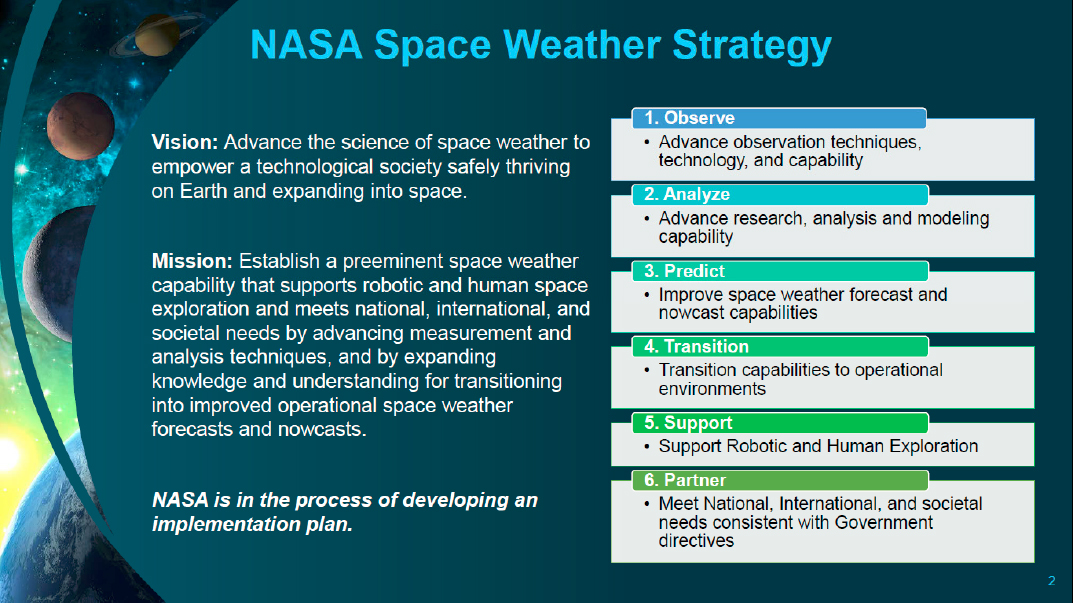
As noted in Jim Spann’s presentation to the workshop on June 16, 2020, NASA’s Space Weather Strategy6 ties directly to the priorities outlined in the 2020 NASA Science Plan, the 2015 and 2019 National Space Weather Strategy and Action Plans, and the recommendations made in the 2013 decadal survey.7 The strategy is designed to address national, international, and societal needs for space weather information through research and advancements in measurement and analysis. It also includes maintenance and enhancement of capabilities to support robotic and human exploration (Figure 3.3).
___________________
6 See NASA, “Space Weather,” https://science.nasa.gov/heliophysics/space-weather.
7 See NASA Science Mission Directorate, 2020, “Science 2020-2024, A Vision for Scientific Excellence,” Washington, DC, https://science.nasa.gov/files/science-pink/s3fs-public/atoms/files/2020-2024_Science.pdf; National Science and Technology Council, 2019, National Space Weather Strategy and Action Plan, Washington, DC, March, https://www.hsdl.org/?view&did=823433; and National Research Council, 2013, Solar and Space Physics: A Science for a Technological Society, Washington, DC: The National Academies Press, https://doi.org/10.17226/13060.
NASA is in the process of establishing a Space Weather Council (SWC) as a means to secure input from community experts across diverse areas relevant to space weather in support of the NASA HPD. The SWC is a subcommittee of the Heliophysics Advisory Committee. NASA is also developing a space weather implementation plan, establishing a NASA Space Weather Science Applications team to serve as a sounding board and implementation team, and conducting a space weather science and measurement gap analysis.8
NASA CURRENT CAPABILITIES
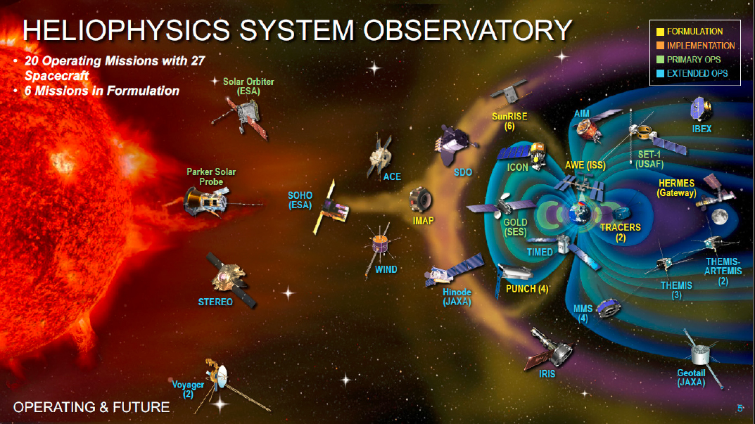
As of June 2020, NASA had 20 operating heliophysics missions with 27 spacecraft and 6 missions in formulation (see Figure 3.4). Five MIDEX Phase A missions announced by NASA HPD on August 28, 2020, have a space weather focus. Although NASA missions are formulated and launched for research purposes, some of them have been particularly important to operational space weather.
The ACE spacecraft, launched in 1997, was designed to study spaceborne energetic particles from the Sun-Earth L1 Lagrange point. It collects and analyzes particles of solar, interplanetary, interstellar, and galactic origins. The data contributes to understanding of the Sun, its interaction with Earth, and the evolution of the solar system. ACE continues to provide space weather reports and warnings of geomagnetic storms that can disrupt communications on Earth and harm astronauts in space. The spacecraft has operated far beyond its 2-year minimum lifetime and goal of 5 years.
Currently ACE is backup to DSCOVR. In addition, the NASA/ESA SOHO, spacecraft, launched in 1995, provides important images of coronal activity with its Large Angle and Spectrometric Coronagraph (LASCO) instrument. LASCO images are used by the SWPC forecast office to characterize the solar corona heating and transient events, including CMEs, and to see the effects of the corona on the solar wind. The LASCO images have also been essential for running the WSA-Enlil solar wind model that became operational at SWPC in October 2011. This model is now one of the tools routinely used for forecasting the time of arrival of Earth-impacting CMEs.
The Ionospheric Connection Explorer (ICON) was launched on October 10, 2019, with a nominal 2-year mission to observe conditions in both the thermosphere and ionosphere. ICON’s science objectives are to understand (1) the source of strong ionospheric variability, (2) the transfer of energy and momentum from Earth’s atmosphere into space, and (3) how solar wind and magnetospheric effects modify the internally driven atmosphere-space system.9 ICON is investigating the low-latitude ionosphere, which is an important operational arena as communications are impacted by scintillation and other plasma structures in the region.10
Another relatively new addition to the suite of NASA research missions that has potential uses in space weather operations and forecasting is GOLD, which was launched on January 28, 2018. Instruments on GOLD are used to examine the response of the upper atmosphere to forcing from the Sun, the magnetosphere, and the lower atmosphere. GOLD is designed to explore the near-Earth space environment from its geostationary orbit, measuring the temperature and composition of neutral gasses in Earth’s thermosphere.
Participants noted that GOLD’s measurements could be used to improve models of the neutral atmosphere, which, in turn, are a critical element of plans for space traffic management. In addition, a type of space weather event investigated with GOLD involves large-scale bubbles that rise up through the equatorial ionosphere to altitudes exceeding 1,000 km, affecting radio frequency communications. Other
___________________
8 See James Spann, NASA, “Heliophysics Division Space Weather Update,” presentation to the workshop, September 9, 2020.
9 K. Rider, T. Immel, E. Taylor, and W. Craig, 2015, “ICON: Where Earth’s Weather Meets Space Weather,” 2015 IEEE Aerospace Conference, March, https://doi.org/10.1109/aero.2015.7119120.
10 ICON Level 2 Data Products are all available at ftp://icon-science.ssl.berkeley.edu/pub/LEVEL.2.
newly selected NASA research missions and projects described below also have the potential to contribute to the space weather enterprise, as will missions and projects still to be selected in the period prior to the end of the SWFO-L1 era.
NSF CURRENT CAPABILITIES
NSF supports fundamental research linked to societal needs for space weather information through investments and partnerships.9 NSF focuses on basic research into the processes that drive space weather. As part of this activity, the agency supports a wide range of ground-based facilities that provide related observations, examples of which include ground-based radars for ionospheric measurements, neutron monitors for cosmic ray flux diagnostics, solar and auroral observatories, and magnetometer networks that support the evaluation of geomagnetically induced currents (GICs). Several ground-based networks supported by NSF are actively providing measurements used as input to space weather operational forecast models or could be used for forecasts. The Global Oscillations Network Group (GONG) consists of six identical solar observing stations that are distributed around Earth. These stations provide nearly continuous solar observations, including magnetograms showing the Sun’s magnetic field on the visible disk at the time it passes over each station. The global distribution of the GONG observatories then provides, in effect, full 24-hour coverage of the Sun’s magnetic field state, including emerging and evolving activity. GONG is operated by the National Solar Observatory. A memorandum of understanding (MOU) between NSF and NOAA supports data input into the operational forecast system. The Bartol Research Institute (University of Delaware) currently operates 10 neutron monitors around the world that measure galactic cosmic rays and solar energetic particles. Similar to the GONG data, this network is currently used predominantly for research. At the workshop, some participants expressed interest in using its data in an operational role relevant to the aviation radiation environment.
NSF supports several groups through the DASI (Distributed Array of Small Instruments) program to monitor Earth’s magnetic field and to provide input into geo-electric field modeling—both are of interest in space weather research and applications (see the June 16, 2020, presentation by Mike Wiltberger). For example, DASI awards include MagStar, which will support development of six new magnetometer stations for GIC studies. These magnetometers add to the sparse coverage of the continental U.S. and provide reliable data for the science as well as operations communities. The SuperMAG project combines worldwide magnetometer data sets in a common public data archive. Other DASI awards relevant to space weather include a collaboration between the Ham Radio Citizen Science Investigation and the Tucson Amateur Radio Corporation to develop a network of personal space weather stations. These instruments will provide research-grade observations of signals-of-opportunity across the high-frequency bands from volunteer observers. The stations will consist of a multi-instrument device that will include a receiver, a ground magnetometer, and a Global Positioning System (GPS)/GNSS receiver to provide precision time stamping. The Space Weather Underground is another DASI award relevant to space weather. This project uses undergraduate and high school students to develop and deploy fluxgate magnetometers across northern New England.
NSF also supports uses of certain data sets obtained in space, such as the conversion of magnetometer data from the commercial iridium communications satellites into global maps of magnetic field-aligned current systems known as the AMPERE project. NSF is also making a major investment in the construction, commissioning, and operation of the Daniel K. Inouye Solar Telescope (DKIST) solar telescope nearing completion on Maui, Hawaii. DKIST is designed primarily for investigating the Sun’s surface and atmosphere at high spatial resolution, toward understanding its fundamental nature. How the knowledge gained from its observations will affect space weather models and/or forecasts is yet to be determined.
JOINT AGENCY INITIATIVES
NASA, NOAA, and NSF representatives at the workshop referenced the “Tri-Agency MOU,” a NASA, NOAA, NSF MOU signed in 2018 that enables ongoing multiagency coordination of research topics in support of the National Space Weather Strategy. A key aspect of this collaboration is the R2O and O2R pipeline. Through independent calls for proposals, NASA, NOAA, and NSF are supporting efforts to facilitate the transition of space weather data and modeling capabilities to U.S. space weather prediction providers and provide feedback from prediction providers to the research community on new research activities needed to improve the operational models. Further information about this forward-looking program is below.
DOD CURRENT CAPABILITIES
The Air Force 557th has the responsibility to provide 24/7 space weather support to all DoD agencies and units and to the national Intelligence Community. Their mission is two-fold—to collect space weather data from DoD ground- and space-based sensors and to provide environmental battlespace awareness through mission-tailored analyses, forecasts, and warnings of mission-impacting space weather to operators, warfighters, planners, and decision makers from command level down to individual units. To accomplish this mission, the 557th operates the Space Weather Operations Center, or Space WOC, the only U.S. military space weather analysis and forecast center, at Offutt Air Force Base, Nebraska.
Users of the 557th space weather services include every branch of service—Army, Air Force, Navy, Marine Corps, Space Force, and Coast Guard—and the national Intelligence Community, from leadership and senior decision makers to specific individual units. Space weather information is provided in support of long-distance radio or satellite communications for command and control, precision navigation and timing from GPS signals, over-the-horizon or tactical radars, high-altitude manned aerial reconnaissance, orbiting spacecraft and sensors, and strategic space launch.
The U.S. Air Force (USAF) operates a two-component, ground-based, real-time, solar observing network, known as the Solar Electro-Optical Network (SEON). SEON consists of the Solar Optical Observing Network (SOON) and the Radio Solar Telescope Network (RSTN), which monitors for solar radio bursts. The internationally located SOON optical telescopes and the RSTN radio telescopes together provide continuous observations of the Sun. SOON captures images of the Sun in the hydrogen-alpha line and white light, as well as producing coarse magnetograms of selected regions. RSTN monitors for solar radio bursts. The Air Force also collects, processes, and disseminates ionospheric data via the Next Generation Ionosonde (NEXION) and the Ionospheric Scintillation TEC Observatory (ISTO) sensor networks.
The 557th and SWPC are partners in providing space weather service to the United States. Each has clearly defined roles and responsibilities, leveraging the capabilities of the other to realize significant cost and resource savings. In simplest terms, the 557th is responsible for military and national intelligence support, and SWPC supports civilian and commercial users. SWPC is a major user of Air Force space weather data, while the 557th relies on NOAA data to accomplish its own space weather mission. The Space WOC relies on ground- and space-based magnetometer data provided through SWPC to analyze, warn, and forecast global geomagnetic activity important to the national intelligence agencies and to the North American Aerospace Defense Command (NORAD). The 557th also depends on alerts of geomagnetic activity from NOAA satellites and solar activity forecasts provided by SWPC to warn and forecast impacts to specific military communications links. The 557th and SWPC forecast centers also provide limited backup operations for each other in the event of computer equipment or communication outages. Space WOC and SWPC coordinate on forecasts and engage in multiple daily space weather teleconferences. The complementary nature of the two missions allows both NOAA and the Air Force to realize cost-sharing advantages and to acquire needed data.
OTHER DEPARTMENTS AND AGENCIES
While much of the workshop focused on NOAA, NASA, NSF, and DoD space weather programs, attention was also given to activities to other departments and agencies that contribute to the space weather enterprise, including the U.S. Geological Survey (USGS), the Department of Energy (DOE), and the Department of State.
USGS supports the development, deployment, and operation of facilities that enhance the understanding of variations of Earth’s magnetic field, a critical component of space weather monitoring associated with solar-terrestrial interactions.9 The USGS magnetometer network constantly measures the surface field at 14 ground-based observatories whose geographic distribution is determined by the need to know the field’s behavior on a global scale. The generation of these continuous records of magnetic field variations, which NOAA’s SWPC uses in its daily reporting, also enables research efforts relevant to interpreting hazards from GICs. Interestingly, it was mentioned at the workshop that there exists the possibility to expand the USGS magnetometer network via contributions from private sources.
Participants also noted the importance of lesser resources. In October 2016, EO 13744 directed DoD, DOE, and DOC to make historical data publicly available from the GPS constellation “to enhance model validation and improvements in space weather forecasting and situational awareness.” The GPS satellites carry DOE/Los Alamos National Laboratory (LANL) energetic particle sensors. In response, in January 2017, 16 years of LANL GPS energetic particle data, covering the period from December 2000 to December 2016, were publicly released. These data are available at NOAA’s National Center for Environmental Information (NCEI) for retrospective studies that can contribute to improved space weather modeling and forecasting. In addition, DoD energetic particle measurements from LANL-GEO satellites and total electron content (TEC) information calculated from the radio frequency data from GPS satellites were made available. (The radio frequency sensors provide TEC measurements from broadband terrestrial radio sources, primarily lightning.) Broader access to such historical data sets has become much more
straightforward with improvements in storage devices and the Internet. The potentially high value for research of this previously unavailable information was noted at the workshop.
The Department of State recognizes, at yet higher administrative levels, that space weather is a global challenge requiring a coordinated international response. The NSW-SAP emphasizes that the world has become increasingly dependent on interconnected and interdependent infrastructure and that any disruption to these critical technologies could have widespread consequences. Many countries are becoming increasingly aware of the risks associated with space weather and the need to monitor and manage these risks. The Department of State takes an active role in mitigating space weather risks through international cooperation. In response to the NSW-SAP, the Bureau of Oceans and International Environmental and Scientific Affairs (OES) organizes the annual Space Weather as a Global Challenge (SWGC) events in Washington, D.C., to strengthen international coordination and cooperation on space weather preparedness. SWGC events have been hosted by the embassies of Italy and Japan. OES also represents U.S. space weather interests in U.N. agencies such as the Committees on the Peaceful Uses of Outer Space and the World Meteorological Organization.
FUTURE PLANNED U.S. CAPABILITIES
NOAA
As noted in the introduction to this proceedings, the current centerpiece of NOAA’s space weather service plan is the SWFO program (see presentation by Elsayed Talaat, September 9, 2020). The SWFO program follows directly from the 2015 and 2019 National Space Weather Strategy and is comprised of two projects: the Compact Coronagraph (CCOR), which will be placed on the GOES-U spacecraft that is currently scheduled for launch in 2024; and the Space Weather Follow-on L1 mission (SWFO-L1), which is planned to launch as a rideshare with the NASA Interstellar Mapping and Acceleration Probe in early 2025.11
The CCOR will image the solar corona with the primary objective of observing Earth-bound CMEs. With CCOR data the size, mass, speed, and direction of CMEs can be derived, giving forecasters the information needed to provide alerts for geomagnetic storms up to days in advance. CCOR is about half the size and weight of a traditional coronagraph. This small size allows CCOR to be accommodated easily on a large variety of spacecraft platforms, including GOES-U as well as SWFO-L1. The L1 orbit allows for continuous unobstructed observation of the corona without interference from Earth. CCOR will replace SOHO’s LASCO imaging of CMEs.
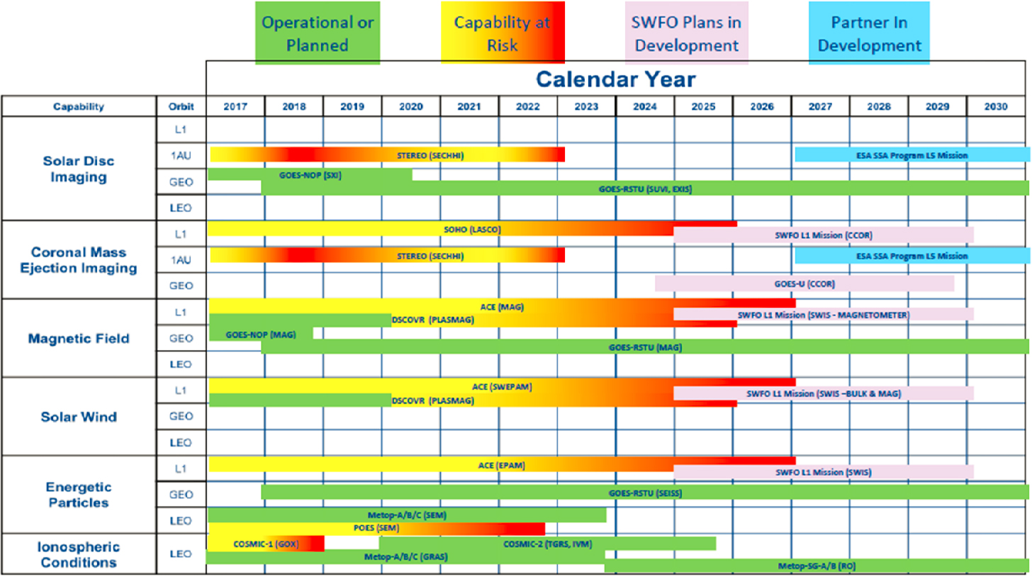
SWFO-L1 will provide real-time 24/7 operations to accommodate the needs of SWPC. Instruments on the spacecraft will collect upstream solar wind data12 and coronal imagery13 and NESDIS/NCEI will archive all space weather data products. NOAA will also be responsible for the development and operation of the ground service that will support all the sensors and the SWFO-L1 spacecraft; the agency is evaluating the addition of 13-16 m dishes near Madrid, Spain, and Dongara, Australia, for this purpose. The current timeline for SWFO planning through 2030 is summarized in Figure 3.5.
___________________
11 Charts in this report date before a December 2020 announcement that the preliminary design review for NASA’s Interstellar Mapping and Acceleration Probe (IMAP) had been moved from February to May 2021, a delay attributed to the precautions taken in response to the COVID-19 pandemic. As a result, the launch readiness date for IMAP was delayed from October 1, 2024, to February 1, 2025.
12 The spacecraft will carry a suite of instruments to make in situ measurements of the solar wind plasma, magnetic field, and energetic particles. Ball Aerospace is under contract to build, integrate, and operate the spacecraft. The Supra Thermal Ion Sensor is under construction at the Space Sciences Laboratory at the University of California, Berkeley, and the magnetometer is being provided by the Southwest Research Institute.
13 Like GOES-U, SWFO-L1 will carry a compact coronagraph developed by the Naval Research Laboratory.
NASA
This section lists only some of the planned missions described at the workshop that are relevant to future space weather observations. They are listed by program element.
MIDEX
In August 2020, NASA announced the selection of five Medium-Class Explorer (MIDEX) proposals for concept studies of missions to help improve understanding of the dynamics of the Sun and Earth’s space environment.14 Each of these proposals will receive $1.25 million to conduct a 9-month mission concept study. Following the study period, NASA will choose up to two proposals to go forward to launch. The selected proposals are as follows:
- HelioSwarm: The Nature of Turbulence in Space Plasmas,
- Solaris: Revealing the Mysteries of the Sun’s Poles,
- STORM: Solar-Terrestrial Observer for the Response of the Magnetosphere,
- MUSE: Multi-slit Solar Explorer, and
- ARCS: Auroral Reconstruction CubeSwarm.
SMEX
The Polarimeter to Unify the Corona and Heliosphere (PUNCH)15 is a NASA Small Explorers (SMEX) program mission—led by the Southwest Research Institute (SWRI)—that will provide the first global images of how the solar corona infuses the solar wind with mass and energy. In addition, the PUNCH satellites will track in three dimensions the Sun’s CMEs as they erupt from the corona out into interplanetary space. The PUNCH mission consists of a constellation of four small satellites in Sun-synchronous LEO, which together will produce deep-field, continuous, three-dimensional (3D) images of the solar corona as it makes a transition to the young solar wind. The PUNCH cameras sense normal visible light and its linear polarization, which allows the 3D location of solar wind features to be measured. Although PUNCH was selected as a basic science mission, NOAA is expecting it to have significant operational benefits.
Launching as a secondary payload on the same rocket with PUNCH will be another recent SMEX selection, TRACERS (Tandem Reconnection and Cusp Electrodynamics Reconnaissance Satellites).16 TRACERS will observe particles and fields at Earth’s northern magnetic cusp region and will study for the first time the extent to which magnetic reconnection is continuous or transient. The mission has three major scientific objectives:17 (1) determine whether magnetopause reconnection is primarily spatially or temporally variable for a range of solar wind conditions; (2) for temporally varying reconnection, determine how the reconnection rate evolves; and (3) determine to what extent dynamic structures in the cusp are associated with temporal versus spatial. The instrumentation consists of ion and electron spectrometers, DC electric and magnetic field and AC wave measurements.
___________________
14 See NASA, “NASA Selects Proposals for New Space Environment Missions,” https://explorers.larc.nasa.gov/HPMIDEX/announcements.html.
15 For details on the mission, see Southwest Research Institute, “PUNCH: The Polarimeter to Unify the Corona and Heliosphere,” https://punch.space.swri.edu/index.php.
16 NASA, 2019, “NASA Selects Missions to Study Our Sun, Its Effects on Space Weather,” June 20, https://www.nasa.gov/press-release/nasa-selects-missions-to-study-our-sun-its-effects-on-space-weather.
17 C Kletzing, 2019, “The Tandem Reconnection and Cusp Electrodynamics Reconnaissance Satellites (TRACERS) Mission,” AGU Fall Meeting Abstracts 2019 (December): A41U2687, https://ui.adsabs.harvard.edu/abs/2019AGUFM.A41U2687K/abstract.
Living With a Star
The Geospace Dynamics Constellation (GDC) is a science mission to dramatically improve scientific understanding of the upper atmosphere and its strong variability in response to energy inputs from the Sun, from near-Earth space, and from the lower atmosphere. This mission concept was recommended by the 2013 decadal survey, Solar and Space Physics: A Science for a Technological Society, for implementation as the next Living With a Star (LWS) mission. The mission has been defined by a community-based Science and Technology Definition Team (STDT)18 and is currently scheduled for launch in 2024.
Artemis
HPD is working across NASA and with partner agencies to support exploration and the agency’s Artemis mission. HPD will fly heliophysics instrumentation in Phase 1 of Artemis to provide an early science return for the program and provide critical space weather and radiation observations needed to protect the astronaut crew. HPD was invited to develop a lunar space environment capability with the Human Exploration and Operations Mission Directorate to launch with the Power and Propulsion Element of Gateway Phase 1. The instrument package was to be delivered no later than November 2021, an insufficient amount of time to do a traditional solicitation. HPD opted to take advantage of this opportunity and directed the task to NASA Goddard Space Flight Center. Moving forward, HPD fully intends to compete all future opportunities and to put themselves in a position to be able to better take advantage of quick turnaround with full community participation. The first heliophysics instrument to fly on Gateway will be the Heliophysics Environmental and Radiation Measurement Experiment Suite (HERMES) instrument. HERMES will help scientists to understand the causes of space-weather variability as driven by the Sun and modulated by the magnetosphere.
NSF
The NSF Atmospheric and Geospace Sciences Section, which provided early support for CubeSat development at universities, recently selected two CubeSat constellation projects: SWARM-EX,19 a constellation of three satellites for study of the ionosphere and thermosphere; and VISORS,20 three CubeSats acting as a single solar telescope to study coronal heating. Responding to a 2013 decadal survey recommendation, NSF has developed a Midscale-1 funding line for projects in the $6 million to $20 million range in addition to the Midscale-2 funding line supporting $20 million to $70 million projects, which can provide infrastructure support spanning the gap between DASI and DKIST.
R202R
A number of participants at the workshop expressed a concern that the United States lacks a formal structure to ensure an efficient space weather research-to-operations-to-research (R2O2R) cycle. They observed that while the foundational components of a cross-organizational structure exists among science
___________________
18 NASA, 2019, GDC STDT Final Report, October 4, https://science.nasa.gov/files/science-red/s3fs-public/atoms/files/GDC%20STDT%20Report%20FINAL.pdf.
19 “NSF Award Search: Award#1936665 - Collaborative Research: CubeSat Ideas Lab: Space Weather Atmospheric Reconfigurable Multiscale Experiment (SWARM-EX) CubeSats,” NSF.gov, 2019, https://www.nsf.gov/awardsearch/showAward?AWD_ID=1936665&HistoricalAwards=false.
20 “NSF Award Search: Award#1936663 - Collaborative Research: CubeSat Ideas Lab: VIrtual Super-Resolution Optics with Reconfigurable Swarms (VISORS),” NSF.gov, 2019, https://www.nsf.gov/awardsearch/showAward?AWD_ID=1936663.
agencies, a framework is needed that incorporates the contributions from industry, academia, and partner-agencies such as DOE, the Department of Homeland Security, the Federal Aviation Administration, and others.21 The fiscal year 2021 Administration Research and Development Budget Priorities joint memorandum identified space weather R2O2R as a budgetary priority that will support critical infrastructure resilience. Both the 2015 and 2019 National Space Weather Strategy and Action Plans directed departments and agencies to identify mechanisms for transitioning models and observational capabilities from research to operations.
In response, NOAA and NASA, in partnership with NSF and the USAF, have embarked on an initiative to develop a formal space weather R2O2R framework that will facilitate the transition of new research into operations and enable the improvement and maintenance of existing operational models. The proposed space weather testbed and proving grounds will bring together forecasters, researchers, and end users in a quasi-operational setting where new models and techniques are assessed and transitioned to operations.
The testbed will be collocated with the SWPC. Proving grounds, such as the NASA Community Coordinated Modeling Center, will emulate operational practices and evaluate new models, data sets, and forecast techniques that can be integrated into the testbed to assess value to the forecast process.
___________________
21 This concern is discussed further in Chapter 7, “Space Weather and Space Climatology: A Vision for Future Capabilities,” of the 2013 decadal survey, Solar and Space Physics: A Science for a Technological Society.


