


Below is the uncorrected machine-read text of this chapter, intended to provide our own search engines and external engines with highly rich, chapter-representative searchable text of each book. Because it is UNCORRECTED material, please consider the following text as a useful but insufficient proxy for the authoritative book pages.
16 Summary The first edition of the HSM included safety performance functions (SPFs) for roadway segments and intersections. However, not all intersection types are covered in the first edition of the HSM. This research was conducted to develop SPFs for new intersection configurations and traffic control types not covered in the first edition of the HSM, for consideration in the second edition of the HSM. Based on input received through a survey of state and local agencies as well as the research project panel, SPFs were developed for the following general intersection configurations and traffic control types: ⢠Rural and urban all-way stop-controlled intersections ⢠Rural three-leg intersections with signal control ⢠Intersections on high-speed urban and suburban arterials (i.e., roadways with speed limits greater than or equal to 50 mph) ⢠Urban five-leg intersections with signal control ⢠Three-leg intersections where the through movements make turning maneuvers at the intersections ⢠Crossroad ramp terminals at single-point diamond interchanges ⢠Crossroad ramp terminals at tight diamond interchanges The research team coordinated with several state agencies to locate candidate intersections for use in developing the SPFs. Site characteristic data were collected for all candidate intersections to select a final list of sites for model development. In addition, crash and traffic volume data were assembled for model development. The specific intersection configurations and traffic control types and severity levels for which SPFs were developed and recommended for consideration in the second edition of the HSM include: Intersections with All-Way Stop Control ⢠Four-leg all-way stop-controlled intersections on rural two-lane highways - Total crashes ⢠Three-leg all-way stop-controlled intersections on urban and suburban arterials - Fatal-and-injury (FI) crashes - Property-damage-only (PDO) crashes ⢠Four-leg all-way stop-controlled intersections on urban and suburban arterials - FI crashes - PDO crashes
17 Rural Three-Leg Intersections with Signal Control ⢠Three-leg signalized intersections on rural two-lane highways - Total crashes ⢠Three-leg signalized intersections on rural multilane highways - Total crashes - FI crashes Intersections on High-Speed Urban and Suburban Arterials ⢠Three-leg stop-controlled intersections on high-speed urban and suburban arterials - Multiple-vehicle (MV) total crashes - MV FI crashes - MV PDO crashes - Single-vehicle (SV) total crashes - SV FI crashes - SV PDO crashes ⢠Three-leg signalized intersections on high-speed urban and suburban arterials - MV total crashes - MV FI crashes - MV PDO crashes - SV total crashes - SV FI crashes - SV PDO crashes ⢠Four-leg stop-controlled intersections on high-speed urban and suburban arterials - MV total crashes - MV FI crashes - MV PDO crashes - SV total crashes - SV FI crashes - SV PDO crashes ⢠Four-leg signalized intersections on high-speed urban and suburban arterials - MV total crashes - MV FI crashes - MV PDO crashes - SV total crashes - SV FI crashes - SV PDO crashes
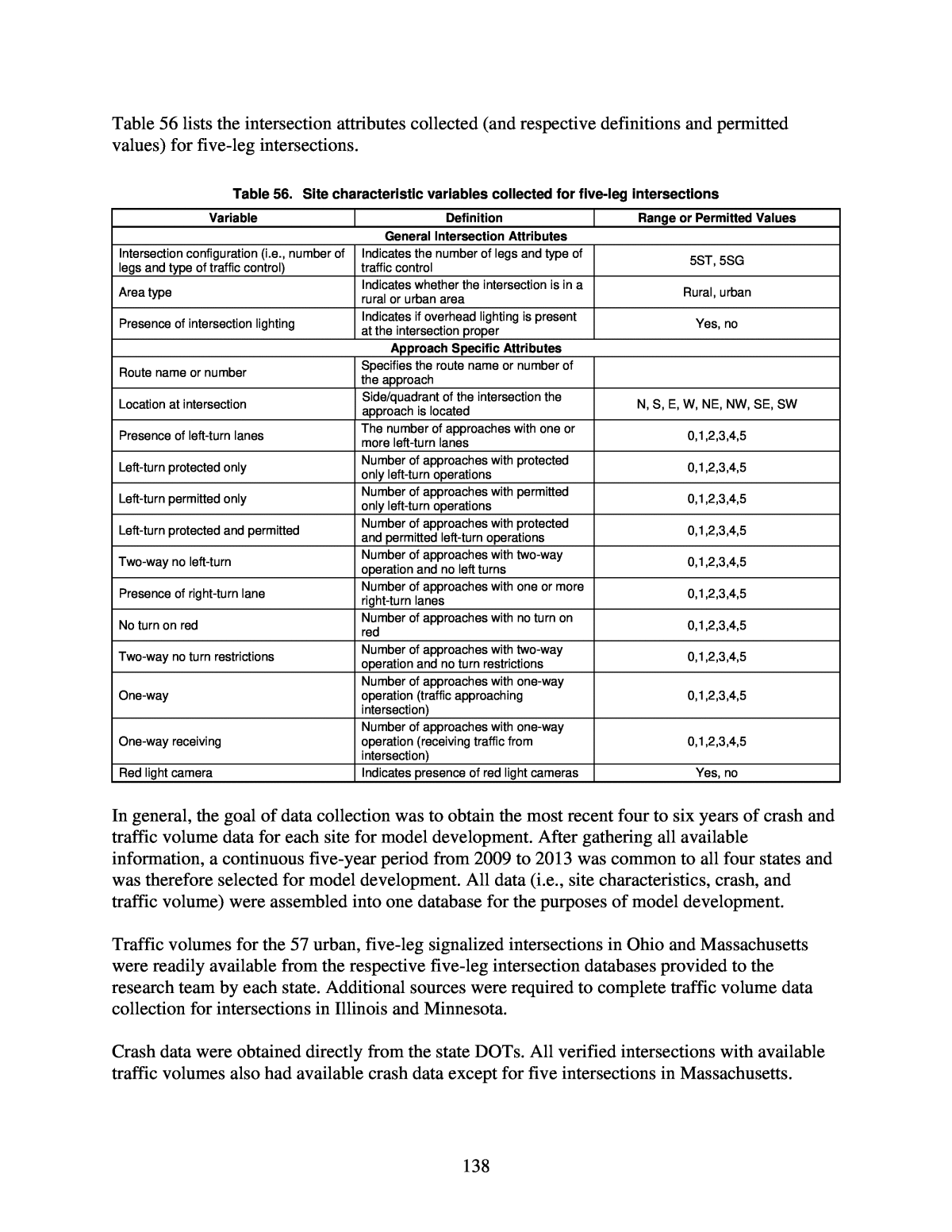
18 Five-Leg Intersections with Signal Control ⢠Five-leg signalized intersections on urban and suburban arterials - MV total crashes - MV FI crashes - MV PDO crashes - SV total crashes - SV FI crashes - SV PDO crashes Three-Leg Intersections Where the Through Movement Makes a Turning Maneuver at the Intersection ⢠Three-leg turning intersections on rural two-lane highways - Total crashes ⢠Three-leg turning intersections on urban and suburban arterials - MV total crashes - MV FI crashes - MV PDO crashes - SV total crashes - SV PDO crashes Crossroad Ramp Terminals at Single-Point Diamond Interchanges ⢠Crossroad ramp terminals at single-point diamond interchanges - FI crashes - PDO crashes Crossroad Ramp Terminals at Tight Diamond Interchanges ⢠Crossroad ramp terminals at tight diamond interchanges - FI crashes - PDO crashes In addition to formulating new SPFs, development of SDFs for the new intersection configurations and traffic control types was explored for potential use in combination with the SPFs to estimate crash severity as a function of geometric design elements and traffic control features. However, due to challenges and inconsistencies in developing and interpreting the SDFs, it is recommended for the second edition of the HSM that crash severity for the new intersection configurations and traffic control types be addressed in a manner consistent with existing methods in Chapters 10, 11, and 12 of the first edition of the HSM, without use of SDFs. Draft text recommended for consideration in the second edition of the HSM is provided as an appendix to the report. In addition, the spreadsheet tools developed as part of NCHRP
19 Project 17-38 were updated to incorporate the new intersection crash prediction models developed as part of this research including intersections with all-way stop control, three-leg intersections with signal control on rural highways, intersections on high-speed urban and suburban arterials, five-leg intersections, and three-leg intersections where the through movement makes a turning maneuver at the intersection; and an unlocked version of the Enhanced Interchange Safety Analysis Tool (ISATe) that includes a module for ramp terminals and excludes modules for freeways and ramps was modified to incorporate the new crash prediction models for ramp terminals at single-point diamond interchanges and tight diamond interchanges.
20 Chapter 1. Introduction 1.1 Background In May 2010, the American Association of State Highway and Transportation Officials (AASHTO) published the first edition of the HSM. This was an important step forward in providing quantitative safety analysis tools to inform decisions made by transportation agencies. HSM Part C includes predictive methods that can be used to anticipate the safety performance of new facilities, assess the safety performance of existing facilities, or estimate the expected effectiveness of proposed improvements to existing facilities. The HSM has become a key safety prediction tool, and state transportation agencies are gaining experience using the HSM in different planning and project contexts. In preparing the first edition of the HSM, decisions that determined which facility types would be addressed by the predictive methods chapters were made based on availability of data, funding limitations, and highway agency priorities. Since the preparation and publication of the first edition of the HSM, several National Cooperative Highway Research Program (NCHRP) projects have been funded to expand the safety knowledge and improve the crash prediction methods provided in Part C of the first edition of the HSM. The HSM Part C presents predictive methods for estimating the expected average crash frequency for specific intersection configurations and traffic control types. The HSM Part C methods can also be applied to multiple roadway segment and intersection sites to estimate the safety performance at the project, corridor, or network levels. The estimation of expected average crash frequency with the Part C methods uses a combination of SPFs, crash modification factors (CMFs), calibration factors, and (when applicable) observed crash data. Table 1 shows the intersection configurations and traffic control types for which models are available in the HSM Part C chapters (Chapters 10, 11, and 12) and the 2014 Supplement to the HSM (Chapter 19) (AASHTO, 2014), which includes crossroad ramp terminal models. In summary, the first edition of the HSM provides the capability to analyze the safety performance of approximately thirteen intersection configurations and traffic control types. Many intersection and traffic control types such as all-way stop-controlled intersections and rural three-leg signalized intersections are not addressed within the first edition of the HSM. Table 1. Intersection types addressed by predictive methods in the first edition of the HSM Intersection Type HSM Chapter 10 11 12 19 Three-leg intersections with stop control on minor approach X X X Four-leg intersections with stop control on minor approaches X X X Three-leg intersections with signal control X Four-leg intersections with signal control X X X Diamond ramp terminals at crossroad X Parclo ramp terminals at crossroad X Free-flow ramp terminals at crossroad X The science of crash frequency prediction and crash severity prediction has evolved as the HSM was developed. The earliest HSM Part C chapterâChapter 10 on rural two-lane, two-way roadsâwas developed as a prototype with no new research beyond what was available at the
21 time of its development. It contains SPFs for all crash severities combined, with tabulated severity distributions in the form of proportions available to separate the total crash frequency predictions into crash frequencies for individual crash severity levels. HSM Chapters 11 and 12 contain separate SPFs by crash severity level. HSM Chapter 19 for ramp terminals contains SPFs to predict the frequency of all FI crash severity levels combined and then implements crash SDFs to separate the FI crash frequency into frequencies by individual severity level as a function of ramp terminal characteristics. Table 2 summarizes the treatment of crash severity in the various HSM Part C chapters. Table 2. Treatment of severity in current HSM models HSM Chapter Treatment of Severity 10 Tabulated crash severity distributions 11 Separate SPFs for KAB and KABC crashes 12 Separate SPFs for KABC and PDO crashes 19 SPFs for FI crashes with crash SDFs and SPFs for PDO crashes Crash severity levels: fatal (K), incapacitating injury (A), non-incapacitating injury (B), possible injury (C), and PDO. In terms of addressing crash types within the HSM predictive methods for at-grade intersections, Chapters 10, 11, and 19 use tabulated collision type distributions that can be applied to crash predictions of all collision types combined, while HSM Chapter 12 contains separate SPFs for predicting single- and MV crashes at intersections. CMFs are used in the existing crash prediction models to account for the effects of intersection skew angle, presence of left- and right-turn lanes, signal phasing, right-turn-on-red, red light cameras, and lighting. This report presents research conducted to develop crash prediction models for additional intersection configurations and traffic control types not currently addressed in the first edition of the HSM. 1.2 Research Objective and Scope The objective of this research was to develop new intersection crash predictive models for consideration in the second edition of the HSM that are consistent with existing methods in HSM Part C and comprehensive in their ability to address a wide range of intersection configurations and traffic control types in rural and urban areas. The main focus of the research was on: ⢠Developing SPFs for intersection configurations and traffic control types not currently addressed in the HSM Part C. ⢠Developing SDFs to be used in combination with SPFs to estimate crash severity as a function of geometric design elements and traffic control features. The crash prediction methods developed in this research include SPFs, CMFs, and SDFs as applicable in a format consistent with the predictive models in the existing HSM Part C and the 2014 Supplement to the HSM (Chapter 19). Data and methodologies used to develop the predictive models consider traffic volumes on all intersecting roads and streets as well as design
22 elements and traffic control features considered by engineers and planners during the project development process. Roundabouts are not addressed in this research, as new crash prediction models were recently developed for possible inclusion in the second edition of the HSM as part of a separate study (NCHRP Project 17-70, Development of Roundabout Crash Prediction Models and Methods). Crash prediction models were developed for the following intersection configurations and traffic control types for consideration in the second edition of the HSM: ⢠Intersections with all-way stop control - Rural four-leg intersections with all-way stop control - Urban and suburban three-leg intersections with all-way stop control - Urban and suburban four-leg intersections with all-way stop control ⢠Three-leg intersections with signal control on rural highways - Three-leg intersections with signal control on rural two-lane highways - Three-leg intersections with signal control on rural multilane highways ⢠Intersections on high-speed urban and suburban arterials - Three-leg intersections with minor road stop control - Three-leg intersections with signal control - Four-leg intersections with minor road stop control - Four-leg intersections with signal control ⢠Urban and suburban five-leg intersections with signal control ⢠Three-leg intersections where the through movements make turning maneuvers at the intersections - Three-leg intersections on rural two-lane highways - Three-leg intersections on urban and suburban arterials ⢠Crossroad ramp terminals at single-point diamond interchanges ⢠Crossroad ramp terminals at tight diamond interchanges NOTE: A crash prediction model for three-leg all-way stop-controlled intersections on rural two- lane highways was developed as part of this research and is included in this report, but due to limited sample size the model was not recommended for consideration in the second edition of the HSM. 1.3 Overview of Research Methodology In Phase I of the research, the research team reviewed and summarized literature related to current HSM intersection crash prediction methods; protocols, best practices, and emerging approaches for predictive model development; and current knowledge related to intersection safety. The research team also surveyed transportation agencies to gain knowledge about their experience with the current HSM intersection predictive methods and assess their needs and priorities as they relate to additional (new) intersection models and/or expanded capabilities of
23 existing models. Based on the results of the literature review and survey, the research team identified and prioritized the types of intersection configurations and traffic control types not currently addressed in the HSM for further consideration in this research. The research team then developed work plans for creating crash prediction models for the higher priority intersection configurations and traffic control types, including: ⢠Intersections with all-way stop control ⢠Three-leg intersections with signal control on rural two-lane and multilane highways ⢠Intersections on high-speed expressways ⢠Three-leg intersections where the through movements make turning maneuvers at the intersections ⢠Three-leg intersections with a commercial driveway forming a fourth leg ⢠Five-leg intersections ⢠Single-point diamond ramp terminals ⢠Indirect left-turn intersections (i.e., U-turns or J-turns) The work plans addressed site selection, data collection, database development, and model development. Other intersection configurations and traffic control types considered for model development but for which work plans for possible execution in Phase II were not developed included: intersections with yield or no control, six-or-more-leg intersections, and diverging-diamond ramp terminals. Work plans were not developed for these intersection configurations and traffic control types due to a combination of priorities from the HSM user survey and the likelihood of successful model development with a sufficient number of sites, exposure, and crash data. For example, because diverging-diamond ramp terminals are relatively new in the United States, limited years of crash data were available for model development at the time of this research. Therefore, the research team did not create a work plan for developing crash prediction models for diverging-diamond ramp terminals. In Phase II of the research, based on a combination of priorities from the HSM user survey, the likelihood of successful model development, and cost, the research team executed the approved work plans to develop crash prediction models for intersections with all-way stop control, three- leg intersections with signal control on rural two-lane and multilane highways, intersections on high-speed expressways, five-leg intersections, and single-point diamond ramp terminals. The research team updated existing spreadsheet tools to include the new crash prediction models developed as part of this research, conducted sensitivity analyses to check that the results were reasonable, and updated/revised the crash prediction models as necessary. In addition, the research team developed recommended text for consideration in the second edition of the HSM and prepared portions of this report that document Phases I and II of the research. In Phase III of the research, the research team executed the approved work plan to develop crash prediction models for three-leg intersections where the through movements make turning maneuvers at the intersections and adapted and executed the work plan for crossroad ramp
24 terminals at single-point diamond interchanges to address crossroad ramp terminals at tight diamond interchanges. Similar to Phase II, the research team updated existing spreadsheet tools to include the new crash prediction models developed in Phase III of this research, conducted sensitivity analyses to check that the results made sense, updated/revised the crash prediction models as necessary, developed recommended text for consideration in the second edition of the HSM, and prepared portions of this report that document Phase III of the research. Throughout the course of the research, the research team kept abreast of other ongoing research related to the HSM that could potentially impact the direction of this research. 1.4 Outline of Report This report presents an overview of research conducted to develop new intersection crash predictive models for consideration in the second edition of the HSM, for intersection configurations and traffic control types not addressed in the first edition of the HSM. The remainder of this report is organized as follows: Chapter 2. Literature Review and Survey of Practice Chapter 3. Development of Models for Use in HSM Crash Prediction Methods: Intersections with All-Way Stop Control Chapter 4. Development of Models for Use in HSM Crash Prediction Methods: Three-Leg Intersections with Signal Control on Rural Highways Chapter 5. Development of Models for Use in HSM Crash Prediction Methods: Intersections on High-Speed Urban and Suburban Arterials Chapter 6. Development of Models for Use in HSM Crash Prediction Methods: Five-Leg Intersections Chapter 7. Development of Models for Use in HSM Crash Prediction Methods: Three- Leg Intersections where the Through Movements Make Turning Maneuvers at the Intersections Chapter 8. Development of Models for Use in HSM Crash Prediction Methods: Crossroad Ramp Terminals at Single-Point Diamond Interchanges Chapter 9. Development of Models for Use in HSM Crash Prediction Methods: Crossroad Ramp Terminals at Tight Diamond Interchanges Chapter 10. Conclusions and Recommendations Chapter 11. References Chapter 12. Abbreviations, Acronyms, Initialisms, and Symbols
25 Appendix AâDraft Text for the Second Edition of the HSM HSM Chapter 10âPredictive Method for Rural Two-Lane, Two-Way Roads HSM Chapter 11âPredictive Method for Rural Multilane Highways HSM Chapter 12âPredictive Method for Urban and Suburban Arterials HSM Chapter 19âPredictive Method for Ramps
26 Chapter 2. Literature Review and Survey of Practice This section summarizes literature relevant to the objectives of this research and results of a survey of transportation agencies intended to gain knowledge about their experience with the current HSM intersection predictive methods and assess their needs and priorities as they relate to additional (new) intersection models and/or expanded capabilities of existing models. Information is summarized according to the following topics: ⢠Review of current HSM intersection crash prediction methods ⢠Protocols, best practices, and emerging approaches for predictive model development ⢠Current knowledge related to intersection safety ⢠Survey of current practice and crash prediction needs ⢠Summary of current knowledge related to intersection crash prediction modeling 2.1 Review of Current HSM Intersection Crash Prediction Methods The current HSM predictive models for intersections were developed in the following order: ⢠HSM Chapter 10âintersections on rural two-lane, two-way roads ⢠HSM Chapter 11âintersections on rural multilane highways ⢠HSM Chapter 12âintersections on urban and suburban arterials ⢠HSM Chapter 19âcrossroad ramp terminals at interchanges HSM Chapters 10, 11, and 12 are included in the first edition of the HSM published in 2010. Chapter 19 was published as a 2014 Supplement to the HSM. Concepts Common Across HSM Intersection Predictive Methods At the most disaggregate level, the HSM predictive methods provide procedures to estimate the expected average crash frequency for individual sites, which are either homogenous roadway segments or intersections (see Figure 1). At-grade intersections are the specific focus of this research. Applying predictive methods for at-grade intersections results in estimates of the expected average crash frequency due to the presence of intersections. This includes crashes occurring within the limits of the intersection (Region A in Figure 1) as well as intersection- related crashes that occur on the intersection legs (Region B in Figure 1). The latter are crashes classified on the crash report as intersection-related or crashes having characteristics consistent with intersection-related crashes (e.g., rear-end collisions in queues). The HSM Appendix A recommends using the intersection-related designation on the crash report when such a field is available to identify the intersection-related crashes that have occurred on the intersection legs.
27 Figure 1. HSM definitions of segments and intersections (AASHTO, 2010) The basic components of the HSM intersection predictive methods used to estimate the expected average crash frequency are: ⢠SPFs ⢠crash severity and collision type distributions ⢠CMFs ⢠calibration procedures ⢠Empirical Bayes (EB) estimation Combining SPFs, CMFs, and calibration factors without the EB procedure results in a predicted average crash frequency, Npredicted, based only on the characteristics of the roadway. Estimates of the expected average crash frequency, which incorporate information about the crash history at the site, are available only after applying the EB technique. The basic model structure to predict the average crash frequency at intersections (Npredicted int) is shown in Equation 1. With Equation 1 and additional equations throughout this report, existing notation and definitions in the first edition of the HSM are used as much as possible; however, some modifications to HSM notation and definitions were made for clarity and consistency as necessary. ð ð ð¶ðð¹ ð¶ðð¹ ⦠ð¶ðð¹ ð¶ (Eq. 1) Where: Npredicted int = predicted average crash frequency for an individual intersection for the selected year (crashes/year) Nspf int = predicted average crash frequency for an intersection with base conditions (crashes/year) CMFyi = crash modification factors specific to intersection type i and specific geometric design and traffic control features y Ci = calibration factor to adjust the SPF for intersection type i to local conditions
28 Intersection SPFs generally take one of the two forms shown in Equation 2 and Equation 3. ð ðð¥ð ð ð ðð ð´ð´ð·ð ð ðð ð´ð´ð·ð (Eq. 2) ð ðð¥ð ð ð ðð ð´ð´ð·ð (Eq. 3) Where: AADTmaj = annual average daily traffic (AADT) on the major road (veh/day) AADTmin = AADT on the minor road (veh/day) AADTtotal = AADT on the major and minor roads combined (veh/day) a, b, c, and d = estimated regression coefficients If AADTs on the two major legs of an intersection differ, the larger of the two AADT values is used for AADTmaj. Similarly, if AADTs on the two minor legs of a four-leg intersection differ, the larger of the two AADT values is used for AADTmin. As needed, AADTtotal can be estimated as the sum of AADTmaj and AADTmin. If AADTs are not available for each evaluation year, interpolation and extrapolation are used. Each SPF also has an associated overdispersion parameter, k. This parameter provides insights into how average crash frequencies at the sites used to estimate the SPF vary compared to the SPF predictions. Larger values indicate larger site-to-site variation around the SPF prediction. HSM Chapter 10âPredictive Methods for Intersections on Rural Two-Lane, Two-Way Roads Chapter 10 of the HSM includes SPFs for the following intersection configurations and traffic control types on rural two-lane, two-way roads: ⢠Three-leg intersections with minor road stop control (3ST) ⢠Four-leg intersections with minor road stop control (4ST) ⢠Four-leg intersections with signal control (4SG) The intersection SPFs for rural two-lane, two-way roads predict an average crash frequency for all crash severities and collision types combined. Default tabular distributions are provided for crash severity and collision type. Crash severities can be disaggregated into five levels: fatal (K), incapacitating injury (A), non-incapacitating injury (B), possible injury (C), and property- damage-only (O or PDO). The collision type distributions are provided for three levels of severity: totalâall severities combined (KABCO), FI severities (KABC), and PDO.
29 HSM Chapter 11âPredictive Methods for Intersections on Rural Multilane Highways Chapter 11 of the HSM includes SPFs for the following intersection configurations and traffic control types on rural multilane highways: ⢠Three-leg intersections with minor road stop control on rural, four-lane divided or undivided highways (3ST) ⢠Four-leg intersections with minor road stop control on rural, four-lane divided or undivided highways (4ST) ⢠Four-leg intersections with signal control on rural, four-lane divided or undivided highways (4SG) For all three intersection types, the intersecting minor roads may be two- or four-lane highways. The intersection SPFs for rural multilane highways predict average crash frequency for all crash severities and collision types combined (KABCO), FI crashes (KABC), and FI crashes with possible injuries excluded (KAB). Default tabular distributions are provided for crash severity and collision type for four levels of severity: total â all severities combined (KABCO), FI severities (KABC), FI severities with possible injuries excluded (KAB), and PDO. Alternative SPFs by collision type and severity level are also provided in Appendix 11B of the HSM for stop-controlled intersections on rural multilane highways. HSM Chapter 12âPredictive Methods for Intersections on Urban and Suburban Arterials Chapter 12 of the HSM includes SPFs for the following intersection configurations and traffic control types on urban and suburban arterials: ⢠Three-leg intersections with minor road stop control (3ST) ⢠Three-leg intersections with signal control (3SG) ⢠Four-leg intersections with minor road stop control (4ST) ⢠Four-leg intersections with signal control (4SG) The HSM intersection predictive methods for urban and suburban arterials separately predict vehicle-pedestrian and vehicle-bicycle crashes. This results in a different model structure for Npredicted int than shown in Equation 1 to calculate total crashes at an intersection, combining vehicle-only plus vehicle-pedestrian plus vehicle-bicycle crashes. This structure of the SPFs for intersections in urban and suburban areas is illustrated in Equation 4 and Equation 5, again using existing HSM notations and variable definitions as appropriate. ð ð ð ð ð¶ (Eq. 4) ð ð ð¶ðð¹ ð¶ðð¹ ⦠ð¶ðð¹ (Eq. 5)
30 Where: Npredicted int = predicted average crash frequency for an individual intersection for the selected year (crashes/year) Nbi = predicted average crash frequency of an intersection (excluding vehicle-pedestrian and vehicle-bicycle crashes) (crashes/year) Npedi = predicted average crash frequency of vehicle-pedestrian crashes of an intersection (crashes/year) Nbikei = predicted average crash frequency of vehicle-bicycle crashes of an intersection (crashes/year) Nspf int = predicted total average crash frequency of intersection-related crashes for base conditions (excluding vehicle-pedestrian and vehicle-bicycle collisions) (crashes/year) CMF1iâ¦CMFyi = crash modification factors specific to intersection type i and specific geometric design and traffic control features y Ci = calibration factor for intersection type i to adjust prediction to local conditions The SPF portion of Nbi, Nspf int, is the sum of two disaggregate predictions by collision type, as shown in Equation 6. ð = ð + ð (Eq. 6) Where: Nbimv = predicted average crash frequency of MV crashes of an intersection for base conditions (crashes/year); and Nbisv = predicted average crash frequency of SV crashes of an intersection for base conditions (crashes/year). SPFs to estimate MV crashes are provided for three severity levels: total (KABCO), FI, and PDO. Because the SPFs for the different severity levels were developed independently, for any given collision type (e.g., MV) and site type (e.g., 3ST), the âtotalâ crash prediction (i.e., all severities) may not equal the sum of the FI and PDO predictions. Preliminary values for FI and PDO crashes obtained directly from the SPFs may be adjusted using an approach illustrated by Equations 7 and 8, provided as an example for MV crashes. The same approach is also used to make these same types of adjustments to the SV crash predictions. ð ( ) = ð ( ) à ( )( ) ( ) (Eq. 7) ð ( ) = ð ( ) âð ( ) (Eq. 8)
31 Where: Nbimv(FI) = predicted average crash frequency of MV, FI crashes of an intersection for base conditions (crashes/year) Nbimv(total) = predicted average crash frequency of MV crashes (all severities) of an intersection for base conditions (crashes/year) Nbimv(PDO) = predicted average crash frequency of MV, PDO crashes of an intersection for base conditions (crashes/year) Nâbimv(FI) = preliminary value for predicted average crash frequency of MV, FI crashes of an intersection for base conditions (crashes/year) Nâbimv(PDO) = preliminary value for predicted average crash frequency of MV, PDO crashes of an intersection for base conditions (crashes/year) Separate collision type distributions for MV, FI; MV, PDO; SV, FI; and SV, PDO are provided for each of the four intersection types addressed by the predictive method. Separate model structures are used to estimate the yearly number of vehicle-pedestrian crashes, Npedi, at stop-controlled and signalized intersections on urban and suburban arterials. The average number of annual vehicle-pedestrian crashes for stop-controlled intersections is estimated with Equation 9. ð = ð à ð (Eq. 9) Where: fpedi = pedestrian crash adjustment factor for intersection type i The average number of annual vehicle-pedestrian crashes for signalized intersections is estimated with Equation 10. ð = ð à ð¶ðð¹ à ð¶ðð¹ à ð¶ðð¹ (Eq. 10) Where: Npedbase = predicted average crash frequency of vehicle-pedestrian crashes for base conditions at signalized intersections (crashes/year) CMF1p = crash modification factor for number of bus stops within 1,000 ft of the center of the intersection CMF2p = crash modification factor for presence of one or more schools within 1,000 ft of the center of the intersection CMF3p = crash modification factor for number of alcohol sales establishments within 1,000 ft of the center of the intersection The predicted number of vehicle-pedestrian crashes per year for base conditions at signalized intersections, Npedbase, is estimated using Equation 11.
32 ð = ðð¥ð ð + ð à ðð(ð´ð´ð·ð ) + ð à ðð + ð à ðð(ðððððð) + ð à ð (Eq. 11) Where: PedVol = sum of daily pedestrian volumes crossing all intersection legs (pedestrians/day), only considering crossing maneuvers immediately adjacent to the intersection (e.g., along a marked crosswalk or the extended path of any approaching sidewalk) nlanesx = maximum number of traffic lanes crossed by a pedestrian, including through and turning lanes, in any crossing maneuver at the intersection considering the presence of refuge islands (only raised or depressed refuges are considered). Base conditions associated with Npedbase are absence of bus stops, schools, and alcohol sales establishments near the intersection. All of the vehicle-pedestrian crashes predicted with Equations 10 and 11 are assumed to be FI crashes (none as PDO). The average number of annual vehicle-bicycle crashes, Nbikei, at all intersection types are predicted using the same model structure as that used to predict Npedi at stop-controlled intersections (see Equation 12). ð = ð à ð (Eq. 12) Where: fbikei = bicycle crash adjustment factor for intersection type i All of the vehicle-bicycle crashes predicted with Equation 12 are assumed to be FI crashes (none as PDO). HSM Chapter 19âPredictive Method for Ramps Chapter 19 of the HSM includes SPFs for the following types of crossroad ramp terminals at service interchanges: ⢠Three-leg terminals with diagonal exit ramp (D3ex) ⢠Three-leg terminals with diagonal entrance ramp (D3en) ⢠Four-leg terminals with diagonal ramps (D4) ⢠Four-leg terminals at four-quadrant parclo A (A4) ⢠Four-leg terminals at four-quadrant parclo B (B4) ⢠Three-leg terminals at two-quadrant parclo A (A2) ⢠Three-leg terminals at two-quadrant parclo B (B2) These ramp terminal types are illustrated in Figure 2. Predictive methods provided in Chapter 19 of the HSM capture both stop control (ST) and signal control (SG) for each of the terminal types
33 and cover crossroad ramp terminals with anywhere from two to six crossroad through lanes (total of both travel directions). Utilizing new notation introduced as part of the 2014 Supplement to the HSM (Chapter 19), signal-controlled crossroad ramp terminal SPFs generally take the form shown in Equation 13. ð , , , , = exp ð + ð Ã ln(ð Ã ð´ð´ð·ð ) + ð Ã ln(ð Ã ð´ð´ð·ð + ð Ã ð´ð´ð·ð ) (Eq. 13) with ð´ð´ð·ð = 0.5 Ã (ð´ð´ð·ð + ð´ð´ð·ð ) (Eq. 14) Where: Nspf,w,SGn,at,z = predicted average crash frequency of a signal-controlled crossroad ramp terminal of site type w (w = D3ex, D3en, D4, A4, B4, A2, or B2) with base conditions, n crossroad lanes, all collision types (at), and severity z (z = FI, PDO) (crashes/year) AADTxrd = AADT on the crossroad (veh/day) AADTin = AADT on the crossroad leg between ramps (veh/day) AADTout = AADT on the crossroad leg outside of the interchange (veh/day) AADTex = AADT on the exit ramp (veh/day) AADTen = AADT on the entrance ramp (veh/day) The AADT of the loop exit ramp at a B4 terminal configuration is not included in AADTex, and the AADT of the loop entrance ramp at an A4 configuration is not included in AADTen. The intersection SPFs predict average crash frequency for all collision types. Default collision type distributions are provided for both FI and PDO crashes. Separate collision type distributions are provided for signalized ramp terminals in rural and urban areas.
34 Figure 2. Ramp terminal configurations (AASHTO, 2014)
35 Figure 2. Ramp terminal configurations (AASHTO, 2014) (continued)
36 One-way, stop-controlled crossroad ramp terminal SPFs generally take the form shown in Equation 15. ð , , , , = exp ð + ð Ã ln(ð Ã ð´ð´ð·ð ) + ð Ã ln(ð Ã ð´ð´ð·ð + ð Ã ð´ð´ð·ð ) (Eq. 15) Where: Nspf,w,ST,at,z = predicted average crash frequency of a one-way, stop-controlled crossroad ramp terminal of site type w (w = D3ex, D3en, D4, A4, B4, A2, B2) with base conditions, all collision types (at), and severity z (z = FI, PDO) All other terms have been previously defined. The intersection SPFs predict average crash frequency for all collision types. Default collision type distributions are provided for both FI and PDO crashes. Separate collision type distributions are provided for one-way, stop-controlled ramp terminals in rural and urban areas. The predictive methods for ramps in Chapter 19 of the 2014 Supplement to the HSM, including crossroad ramp terminals, utilize SDFs to disaggregate the predicted average frequency of FI crashes into an estimate of average crash frequency for the following severity levels: fatal (K), incapacitating injury (A), non-incapacitating injury (B), and possible injury (C). Adopting the SDF notation introduced as part of the 2014 Supplement to the HSM, the SDFs for crossroad ramp terminals are illustrated in Equations 16 through 19. ð , , , = ( )., , ( ) ( ) Ã ð | , , , (Eq. 16) ð , , , = ( )., , ( ) ( ) Ã 1 â ð | , , , (Eq. 17) ð , , , = ( )., , ( ) ( ) (Eq. 18) ð , , , = 1 â (ð + ð + ð ) (Eq. 19) Where: PaS,x,at,K = probability of a fatal crash (given that a fatal or injury crash occurred) for all ramp terminal sites (aS) based on all collision types (at) and control type x (x = ST: one-way stop control; Sgn: signal control, n-lane crossroad)
37 PaS,x,at,A = probability of an incapacitating injury crash (given that a fatal or injury crash occurred) for all ramp terminal sites (aS) based on all collision types (at) and control type x (x = ST: one-way stop control; Sgn: signal control, n-lane crossroad) PaS,x,at,B = probability of a non-incapacitating injury crash (given that a fatal or injury crash occurred) for all ramp terminal sites (aS) based on all collision types (at) and control type x (x = ST: one-way stop control; Sgn: signal control, n-lane crossroad) PaS,x,at,C = probability of a possible injury crash (given that a fatal or injury crash occurred) for all ramp terminal sites (aS) based on all collision types (at) and control type x (x = ST: one-way stop control; Sgn: signal control, n-lane crossroad) Vj = systematic component of crash severity likelihood for severity j PK|K+A,aS,x,at = probability of a fatal crash given that the crash has a severity of either fatal or incapacitating injury for all ramp terminal sites (aS) based on all collision types (at) and control type x (x = ST: one-way stop control; Sgn: signal control, n-lane crossroad) Csdf,aS,x = calibration factor to adjust SDF for local conditions for all ramp terminal sites (aS) and control type x (x = ST: stop control, Sgn: signal control, n-lane crossroad) The basic model form for the systematic components of crash severity likelihood at crossroad ramp terminals is illustrated by Equation 20. ð = ð + ð Ã ð¼ , + ð Ã ð + ð + ð Ã ð¼ + (ð Ã ð¼ ) (Eq. 20) Where: Ip,lt = protected left-turn operation indicator variable for crossroad (= 1 if protected operation exists, 0 otherwise) ndw = number of unsignalized driveways on the crossroad leg outside of the interchange and within 250 ft of the ramp terminal nps = number of unsignalized public street approaches to the crossroad leg outside of the interchange and within 250 ft of the ramp terminal Ips = non-ramp public street leg indicator variable (= 1 if leg is present, 0 otherwise) a, b, c, d, and e = estimated SDF coefficients Chapter 19 of the HSM does not provide a predictive method for crossroad ramp terminals with all-way stop control, but it does include an interim method that utilizes the one-way stop control models.
38 HSM Predictive Method Calibration The intersection predictive methods in the HSM contain calibration factors to adjust predictions of the HSM models, developed with data from selected jurisdictions and for specific time periods, to be applicable to other jurisdictions and time periods. Equation 1, for example, presents the calibration factor in general form as Ci, with i representing a specific site type. The notation Ci is generally used to represent predictive model calibration factors when the site type of interest is an intersection. Calibration factors associated with the intersection predictive methods are calculated as the ratio of total observed crash frequencies for a selected set of sites to total predicted average crash frequencies for the same sites, during the same time period, determined using the applicable predictive method. This ratio is illustrated in Equation 21. ð¶ = â â (Eq. 21) Calibration is to be performed separately for each specific facility and site type. The introduction of SDFs in the freeway and interchange chapters of the HSM resulted in the need for an SDF calibration method. The calibration method utilizes comparisons of observed versus predicted severe crashes (i.e., fatal, incapacitating injury, and non-incapacitating injury crashes). First, observed crash data from the calibration sites are used to calculate the observed probability of a severe crash, given that an FI crash has occurred, using Equation 22. ð , , , , = â â , ( ), ( ), , , , ( ), ( ), , , , ( ), ( ), , ,â â , ( ), ( ), , , , ( ), ( ), , , , ( ), ( ), , , , ( ), ( ), , , (Eq. 22) Where: Po,aS,ac,at,KAB = observed probability of a severe crash (i.e., K, A, or B) for all collision types (at), all sites (aS), and all control types (ac) No,w(i),x(i),at,m,t = observed crash frequency for site i with site type w(i), year t, control type x(i), for all collision types (at), and severity m (m = K, A, B, C) nsites = number of sites nc = number of years in calibration period Next, the predicted average crash frequency is used to calculate the predicted probability of a severe crash, given that an FI crash has occurred, using Equation 23. ð , , , , = â â , ( ), ( ), , , , ( ), ( ), , , , ( ), ( ), , ,â â , ( ), ( ), , , , ( ), ( ), , , , ( ), ( ), , , , ( ), ( ), , , (Eq. 23)
39 Where: Pp,aS,ac,at,KAB = predicted probability of a severe crash (i.e., K, A, or B) for all collision types (at) all sites (aS) and all control types (ac); Np,w(i),x(i),at,m,t = predicted crash frequency for site i with site type w(i), year t, control type x(i), for all collision types (at), and severity m (m = K, A, B, C); The final step involves computing the calibration factor using Equation 24. ð¶ , = , , , ,. , , , , à . , , , ,, , , , (Eq. 24) Calibration is performed separately for each SDF. Empirical Bayes Estimation This section describes the EB estimation, as used in Step 15 of the HSM Predictive Method (presented in the Part C Introduction and Applications Guidance) when applicable. EB estimation combines a predicted average crash frequency for a site with an observed crash frequency for that site, resulting in an estimate of the expected average crash frequency. Combining the observed crash frequency for a specific site with the predicted crash frequency for other similar sites increases the accuracy of the expected crash frequency estimate. The EB method reduces regression-to-the-mean (RTM) bias in estimates obtained from observed crash frequency alone, where locations experiencing higher than average crash frequency over some time period will naturally see lower crash frequencies in a following time period and vice versa. Two or more years of crash data are desirable for applying the EB method. A more straightforward EB estimation can occur when crash data are assigned to each segment or intersection (i.e., a site-specific EB analysis). However, when crash data are not segment- or intersection-specific, the EB method can be applied across multiple, aggregated sites (i.e., project-level EB method). Only the site-specific EB method is discussed here. Applying the site-specific EB method results in an estimate of expected average crash frequency for a site (Nexpected), produced by combining predicted average crash frequency for the site (Npredicted) with the observed crash frequency for that same site (Nobserved). Nexpected for a site is calculated using Equations 25 and 26. ð = ð¤ à ð + (1.00 â ð¤) à ð (Eq. 25) ð¤ = à â (Eq. 26)
40 where: Nexpected = expected average crash frequency obtained by combining the predicted average crash frequency (Npredicted) with the observed crash frequency (Nobserved) using the EB method Npredicted = predicted average crash frequency obtained using the appropriate predictive model Nobserved = observed crash frequency w = weighted adjustment to be placed on the HSM predictive model estimate k = overdispersion parameter associated with the SPF 2.2 Protocols, Best Practices, and Emerging Approaches for Predictive Model Development This section discusses formal protocols and guidance for predictive model development, as well as best practices for predictive model development identified from past experience and emerging approaches. This discussion focuses on issues applicable to modeling at-grade intersection safety performance and does not necessarily address issues relevant only to roadway segments or ramps. Development of SPFs SPFs for intersections are equations that relate the expected intersection crash frequency (possibly by type and/or severity) for some defined time period to characteristics of the intersection. In the context of the intersection predictive methods in the HSM, SPFs are used to estimate a predicted average intersection crash frequency (in units of crashes/year) for a given combination of major- and minor road traffic volumes. SPFs in the HSM are provided for different facility types, numbers of intersecting legs, and traffic control types. Intersection SPFs can also appear as âfuller models,â which include additional variables beyond only major- and minor road traffic volumes for crash prediction. A synthesis paper published in Transportation Research Part A (Lord and Mannering, 2010) contains descriptions of key issues and methodological approaches applicable to SPF-like models that have been used to understand how various factors influence the frequency of crashes. Data and methodological issues explored in the paper include overdispersion, underdispersion, time-varying explanatory variables, temporal and spatial correlation, low sample mean, small sample size, injury severity and collision type correlation, omitted variable bias, endogenous variables, functional form, and fixed parameters. The wide variety of methods that appear in the published literature to deal with these issues are then identified and described, including Poisson regression, negative binomial regression, Poisson-lognormal models, zero- inflated models, Conway-Maxwell-Poisson model, Gamma model, generalized estimating equation model, generalized additive models, random effects models, negative multinomial models, random-parameters models, bivariate/multivariate models, finite mixture/Markov switching models, duration models, hierarchical/multilevel models, neural and Bayesian network models, and support vector machine models. Finally, maximum likelihood and Bayesian estimation methods are briefly covered. Similar to the synthesis paper by Lord and Mannering
41 (2010), the Federal Highway Administration (FHWA) Safety Performance Function Development Guide: Developing Jurisdiction-Specific SPFs (Srinivasan and Bauer, 2013) provides guidance for states interested in developing their own SPFs and addresses a variety of issues which may be encountered when developing jurisdiction-specific SPFs. Recent advances in SPF development allow for the estimation of variance and 95% confidence intervals for the estimate of average crash frequency resulting from multiplying SPFs and CMFs. More advanced SPFs deal with temporal correlation, usually through aggregating multiple years of data for a particular set of sites, as well as spatial correlation by using more complex modeling techniques. Model forms other than negative binomial are sometimes used to handle excessive numbers of sites with no crashes (zero-inflated models), to achieve more flexible model forms (Poisson-lognormal), and to deal with both overdispersion and underdispersion (Conway- Maxwell-Poisson models). These model forms are discussed very briefly in the FHWA SPF Guide, but the guide provides additional references for more complex model forms. The progress made in methodological approaches used to understand how various factors influence the frequency of crashes has been substantial (Lord and Mannering, 2010). The most common method for developing intersection SPFs is to estimate a negative binomial (NB) regression model with number of intersection and intersection-related crashes as the dependent variable and traffic volumes, geometry, traffic control devices, and other factors characterizing an intersection as independent variables. NB regression requires the specification of the âadditional dispersionâ (additional when compared to a Poisson model) that is common to crash data. It is typical for this âadditional dispersionâ to be specified as a dispersion parameter multiplied by the expected number of crashes squared (NB-2 model). The dispersion parameter for intersections is usually treated as a fixed parameter. There are some variations to the standard NB-2 model that can still be integrated with existing HSM predictive methods while at the same time possibly improving the parameter estimates associated with traffic volumes, geometric features, traffic control, and other factors in the models in terms of âaccuracyâ and âprecision.â Count regression models with identification variables for counties, districts, regions, or states treated as âfixed effectsâ (see Le and Porter, 2012) or ârandom effectsâ (see Shankar et al., 1998) are modeling alternatives that help to address crash- influencing factors that may be common to groups of intersections, but that are not captured by the models. The methods were successfully employed in NCHRP Project 17-45, Enhanced Safety Prediction Analysis Tool for Freeways and Interchanges (Bonneson et al., 2012). Random effects models were also used to estimate multi-state models in developing the HSM Chapter 12 SPFs. The negative multinomial modeling approach can also be used to address correlations in disturbance terms across observations, and is particularly useful when a single intersection appears in a database multiple times due to multiple observation years that are kept disaggregated. NB regression, count regression models with âfixed effectsâ and ârandom effects,â and negative multinomial modeling were considered most relevant for developing SPFs for this research. Development of Crash Modification Factors CMFs are multiplicative factors used to compute the expected number of crashes at a site with a certain set of characteristics. CMFs are multiplied by the expected number of crashes at that site
42 without those characteristics, commonly referred to as âbase conditionsâ in the HSM predictive model context. For any given characteristic or treatment, CMF values greater than one indicate that the characteristic or treatment is expected to increase the number of crashes compared to the base conditions, while values lower than one indicate that the treatment is expected to decrease the number of crashes. FHWAâs A Guide to Developing Quality Crash Modification Factors (CMF Guide) (Gross et al., 2010) was published with a primary purpose of describing methods behind the development of CMFs and providing guidance for adequate application and reporting of CMFs, depending on the available data and treatments that CMFs need to address. Crash Modification Functions (CMFunctions) may also be used to compute CMFs for a specific site, and while they require more data than computing single CMF values, they allow the CMF values to vary as site characteristics change, which may make them preferable among practitioners. A variety of study approaches have been used to develop CMFs including EB before-after studies, before-after with comparison group studies, full Bayes studies, surrogate measure studies, cross-sectional studies, case-control studies, cohort studies, meta-analysis studies, and expert-panel studies. For all types of CMF studies, the number of treatment and non-treatment sites and duration of the before and after periods, as well as the size of treatment effect, impact the estimated CMFs and their associated standard errors. Before-after studies are considered the most dependable study design for CMF development, but in both national HSM discussions and the research literature, there is emerging interest in whether quality CMFs can be developed using the estimated parameters of regression models from cross-sectional studies. The current state of the research literature indicates that it is possible to estimate reliable CMFs from cross- sectional studies as long as care is taken in the data collection and modeling approaches used. Desirable characteristics of such studies include: ⢠Carefully collected databases created using both traditional and non-traditional data sources to confirm and enhance the independent variable measurements ⢠Logical variable specifications with appropriate boundary conditions ⢠Repeated, consistent findings across studies and locations ⢠Implementation of observational study design methods, such as the propensity scores- potential outcomes framework to significantly reduce selection bias Treatment of Crash Severity in Predictive Methods The way in which crash severity is addressed within the HSM intersection predictive methods has evolved over time as chapters were developed. In Chapter 10 (Rural Two-Lane, Two-Way Roads), SPFs predict average crash frequency for all crash severities. Using proportional distributions, crash severities can be disaggregated into five levels: fatal (K), incapacitating injury (A), non-incapacitating injury (B), possible injury (C), and property-damage-only (O or PDO). In Chapter 11 (Rural Multilane Highways), the intersection SPFs predict average crash frequency for all crash severities combined (KABCO), FI crashes (KABC), and FI crashes with possible injuries excluded (KAB). No additional levels of disaggregation by severity level are available. In Chapter 12 (Urban and Suburban Arterials), intersection SPFs predict average crash frequency for all crash severities combined (KABCO), FI crashes (KABC), and PDO crashes. No additional levels of disaggregation by severity level are available. The urban and suburban
43 intersection SPFs for different levels of severity were independently estimated. For any given collision type (e.g., MV) and site type (e.g., 3ST), it is likely that a âtotalâ crash prediction (i.e., all severities) will not equal the sum of the FI and PDO predictions. Preliminary values for FI and PDO crashes obtained directly from the SPFs are therefore adjusted to make this summing process work. All vehicle-pedestrian and vehicle-bicycle crashes that are predicted as part of the urban and suburban intersection methods are treated as FI crashes (none as PDO). Finally, in Chapter 19 (Predictive Method for Ramps), intersection SPFs predict average crash frequency for FI crashes (KABC) and PDO crashes at crossroad ramp terminals of freeway interchanges. SDFs are then used to further disaggregate the SPF predicted average frequency of FI crashes into an estimate of average crash frequency for the following severity levels: fatal (K), incapacitating injury (A), non-incapacitating injury (B), and possible injury (C). Two SDFs are provided, one for one-way stop-control terminals and another for signalized terminals. These two SDFs are applicable to other subcategories of terminal types within these broader categories. The evolution in the way severity is addressed in HSM predictive methods explicitly recognizes that severity distributions may change with traffic volumes, design decisions, traffic control, and other characteristics. A synthesis paper by Savolainen et al. (2011) presents key issues and methodological approaches that have been used to understand how various factors influence the severity outcomes of crashes. While Savolainen et al. state that there has been substantial progress made in modeling crash severities, this progress has been made and tracked primarily by those making more theoretical advancements in methodological areas of crash severity modeling. Only more recently have these methods been incorporated into applied, product- oriented safety research, such as research aimed at developing predictive methods. For example, the research that resulted in the development of HSM Chapter 19 (Predictive Method for Ramps) utilized multinomial logit (MNL) models to develop the SDFs. Generally speaking, the databases used to estimate severity models and corresponding SDFs consist of the same crashes and intersections as the databases used to estimate the frequency models and corresponding SPFs, but the databases are restructured so that the basic observation unit (i.e., database row) is the crash instead of the intersection. To more seamlessly work together with existing HSM predictive methods, the multinomial logit (e.g., Shankar and Mannering, 1996), nested logit (e.g., Shankar et al., 1996), and the binary logit (e.g., Al-Ghamdi, A., 2002) are the most logical severity modeling alternatives. These three severity modeling alternatives begin with defining a set of linear functions (Sjr), shown in general form in Equation 27, that define how injury severity outcome j for crash r is determined. ð = ð β + ð (Eq. 27)
44 Where: Xjr = a row of observed characteristics (e.g., driver, vehicle, roadway, environment) associated with crash r that have an impact on injury severity outcome j βj = a vector of parameters to be estimated that quantify how the characteristics in Xjr impact injury severity outcome j εjr = a disturbance term that accounts for unobserved and unknown characteristics of crash r that impact injury severity outcome j There are as many such linear functions as there are possible injury severity outcomes. The probability of having injury severity outcome j for crash r is then the probability that the linear function for that severity outcome is larger than the functions for any other severity outcome, i.e.: ð (ð) = ð ð ⥠ð â ð½ â ð½ (Eq. 28) or ð (ð) = ð ð β + ð ⥠ð β + ð â ð½ â ð½ (Eq. 29) with J denoting all possible injury outcomes for crash r, and Pr(j) the probability of crash r having injury outcome j. Obviously, the injury severity outcome of a crash, given a set of observable characteristics, can never be predicted with certainty because the values of the disturbance terms for the different injury outcomes are never known with certainty. The severity models, ultimately leading to the SDFs, are developed by making assumptions about the properties of these disturbance terms. The multinomial logit model is commonly used to model crash severity in cases with three or more possible injury severity outcomes. In NCHRP Project 17-45, for example, FI outcomes were classified as either fatal and incapacitating injury (KA), non-incapacitating injury (B), or possible injury (C). If the disturbance terms of the linear functions referenced in Equations 27-29 are assumed to be identically and independently distributed as extreme value, the multinomial logit model, shown in Equation 30, results. ð (ð) = ( )â ( )â (Eq. 30) For model estimation, one of the injury outcome categories is arbitrarily selected as the âbase injury severity outcome,â and all of its corresponding parameters (i.e., βjâs) are represented with zeroes. The remaining βjâs that are estimated represent the values for the βjâs relative to the βjâs for the selected âbase injury severity outcome.â This results in the form seen in the HSM Chapter 19 SDFs and provided in more general form in Equation 31. ð (ð) = ( )â ( ) (Eq. 31)
45 Where j in this case represents all possible injury severity outcomes except for the base outcome. In NCHRP Project 17-45, for example, possible injury (C) was selected as the base outcome. Pr(KA) and Pr(B) were predicted using an equation similar to Equation 28; Pr(C) was then predicted as 1 - Pr(KA) - Pr(B). The MNL model provides a high level of flexibility in terms of model specification, allowing exploration of various possible severity-related relationships such as: ⢠Certain roadway characteristics and traffic conditions impacting the probability of some severity outcomes relative to the base outcome, but not impacting others ⢠Certain roadway characteristics and traffic conditions increasing (or decreasing) the probability of the higher severity outcomes relative to the base outcome, while also increasing (or decreasing) the probability of the lower severity outcomes The MNL assumption that the disturbance terms of the linear functions referenced in Equations 27-29 are identically and independently distributed as extreme value leads to a practical model form for interpretation and prediction. However, the main disadvantage of the MNL model is that it is characterized by the independence of irrelevant alternatives (IIA) assumption, meaning that it does not appropriately handle scenarios with two or more severity outcomes that are close substitutes with shared unobserved effects captured by their disturbance terms (i.e., violations of the IIA assumption). The nested logit model is a common modeling alternative for discrete outcome data when the IIA assumption is violated. In the case of crash injury severity outcomes, it might be expected that the linear functions, Sjr, for possible injury (C) and no injury (O) have some shared unobserved effects captured in the disturbance terms. This results in a nesting structure, similar to the example illustrated in Figure 3. Figure 3. Example of nested structure for crash injury severities (Savolainen et al., 2011) The nested logit model handles this nesting structure through making the assumption that the disturbance terms of the linear functions referenced in Equations 27-29 are generalized extreme
46 value distributed, resulting in the model structure shown in Equations 32-34 (as outlined in Washington et al., 2010 and Savolainen et al., 2011). ð (ð) = ( )â ( )â (Eq. 32) ð (ð|ð) = ( | )â ( | )â (Eq. 33) ð¿ð = ðð â ðð¥ð(ð ð½ | )â (Eq. 34) Where: Pr(j) = probability of crash r having injury outcome j, where j is an outcome in the âtop levelâ of the nest (e.g., fatal injury, evident injury, or no evident injury) Xjr, Xqr = rows of observed characteristics (e.g., driver, vehicle, roadway, environment) associated with crash r that have an impact on injury severity outcome j (across the top level of the nests) and q (within the nests), respectively βj, βq|j = vectors of parameters to be estimated that quantify how the characteristics in Xjr and Xqr impact injury severity outcome j (across the top level of the nests) and q (within the nests), respectively Pr(q|j) = probability of crash r having injury outcome q, conditioned on the outcome being in category j (e.g., probability of either possible injury or no injury conditioned on a no evident injury crash) LSjr = âlog-sumâ or âinclusive valueâ for the nest (i.e., the expected value of the linear functions, such as those in Equation 27, for the outcomes within the nest) Ïj = âlog-sum coefficientâ to be estimated Within this framework, the probability of having one of the severity outcomes (q) within the nest, Pr(q), is given in Equation 35 (with all terms previously defined). Pr(q) = Pr(j) à Pr(q|j) (Eq. 35) For the nested logit to be considered an appropriate modeling alternative for a given context, the âlog-sum coefficientâ should fall between zero and one. If the parameter equals one, the model reduces to the MNL. A hypothesis test can be set up to determine whether the âlog-sum coefficientâ is different than one at some level of statistical significance. This approach was used in NCHRP Project 17-45 before selecting the MNL as an appropriate model form for estimating the HSM Chapter 19 SDFs. In cases where crash severity is assigned one of two possible outcomes [e.g., fatal and incapacitating injury (KA) or not (BCO)], there are only two such linear functions. With the disturbance terms of these two functions identically and independently distributed as extreme value, the binary logit model results, shown in Equation 36.
47 ð (ð) = ( )( ) (Eq. 36) The outcome j in this case represents one of two possible injury severity outcomes. Continuing the example from the previous paragraph, an injury severity outcome can be classified as either fatal and incapacitating injury (KA) or not (BCO). If the BCO outcomes are set to the âbase injury severity outcome,â the binary logit parameters could be estimated and the severity probabilities predicted using Equations 37 and 38. ð (ð¾ð´) = ( )( ) (Eq. 37) ð (ðµð¶ð) = 1 â ð (ð¾ð´) (Eq. 38) The binary logit is a key modeling alternative for multiple reasons, including: ⢠Sample size challenges, particularly those associated with more severe injury outcomes, may limit the SDFs to being only âtwo-category SDFsâ (an example of which is provided in Equations 37 and 38); ⢠When injury severity outcomes are classified into more than two categories, estimating a series of binary logit models instead of an MNL model can âtemperâ estimation issues when IIA is violated. Anytime that more than one severity outcome has to be combined into one severity outcome category for SDF estimation (e.g., combining both âKâ and âAâ crashes into a âKAâ category), the severity outcome proportions can later be disaggregated with a combination of the SDF probability prediction and default severity distributions for those categories. Treatment of Collision Type in Predictive Methods The way in which collision type is addressed within the HSM intersection predictive methods is also different from chapter to chapter, but not to the extent of severity differences. In Chapter 10 (Rural Two-Lane, Two-Way Roads), Chapter 11 (Rural Multilane Highways), and Chapter 19 (Ramps), intersection SPFs predict average crash frequency for all collision types combined. Default collision type distributions are then used to disaggregate the crash predictions by collision type. Different default collision type distributions are provided for different crash severities. An appendix to Chapter 11 also provides alternative SPFs by collision type for intersections along rural multilane highways. The HSM notes the advantage of this is that more accurate safety prediction for a specific collision type can be obtained using a model developed specifically for that collision type than from using a model for all collision types multiplied by a collision type proportion. The disadvantages include model availability for only selected collision types and the sum of predictions from a series of collision type models will not necessarily equal the prediction for a model with all those collision types combined. There were no base conditions or CMFs specific to the alternative SPFs. In Chapter 12 (Urban and Suburban Arterials), intersection SPFs and other predictive method components predict average crash frequency for the following collision types: MV (excluding crashes involving a pedestrian or bicyclist); SV (excluding crashes involving a pedestrian or bicyclist); vehicle-pedestrian; and
48 vehicle-bicycle. Handling collision types within HSM predictive methods remains a topic of ongoing research. Calibration Factors for Predictive Models The HSM calibration procedures for both predictive methods and SDFs are described in Section 2.1.6 of this report. In 2014, Bahar and Hauer (2014) prepared A Userâs Guide to Develop Highway Safety Manual Safety Performance Function Calibration Factors to expand on calibration-related information provided to an HSM user (currently contained in the HSMâs Appendix A of Part C), covering four key aspects of predictive model calibration: ⢠Why calibration is needed ⢠How to implement the calibration process ⢠How to assess the results of calibration ⢠How to prepare for future calibration updates 2.3 Current Knowledge Related to Intersection Safety This section summarizes recent literature related to intersection safety, focusing on: ⢠Predictive models developed for intersections configurations and traffic control types not currently addressed in the HSM; ⢠Recently developed CMFs for intersections that could potentially be incorporated, or used in conjunction, with intersection predictive models. For this section, the research team reviewed literature published since 2008. Predictive Models for Intersection Configurations and Traffic Control Types Not Currently Addressed in the HSM Several predictive models have been developed for intersection configurations and traffic control types not currently addressed in the HSM, including three-leg intersections with signal control on rural highways and three- and four-leg intersections with all-way stop control on rural highways. Virginia Department of Transportation (DOT) developed SPFs using NB regression for several different intersection types, including three-leg intersections with signal control on rural highways (Garber and Rivera, 2010). SPFs were created for both total and FI severity levels. A total of 183 rural signalized three-leg intersections were used for model development. The models consisted of major- and minor road AADT. Safety Analyst contains SPFs developed for use in predicting the safety performance of specific site subtypes (Harwood et al., 2009). The SPFs developed for Safety Analyst predict crash frequency as a function of AADT only. NB regression was used to create the SPFs. Data from Minnesota were used to develop the intersection SPFs for Safety Analyst. Within Safety Analyst, SPFs to predict total and FI crash frequencies are available for the following intersection configurations and traffic control types not currently addressed in the HSM:
49 ⢠Three-leg intersections with all-way stop control on rural highways - Software makes use of SPF for four-leg intersections with all-way stop control on rural highways for three-leg intersections with all-way stop control on rural highways ⢠Three-leg intersections with signal control on rural highways - Software makes use of SPF for four-leg intersections with signal control on rural highways for three-leg intersections with signal control on rural highways ⢠Four-leg intersections with all-way stop control on rural highways ⢠Three-leg intersections with all-way stop control on urban streets - Software makes use of SPF for four-leg intersections with all-way stop control on rural highways for three-leg intersections with all-way stop control on urban streets ⢠Four-leg intersections with all-way stop control on urban streets - Software makes use of SPF for four-leg intersections with all-way stop control on rural highways for four-leg intersections with all-way stop control on urban streets The Pennsylvania DOT developed SPFs (Donnell et al., 2014) for rural two-lane highway segments and intersections. Of the five types of intersections examined, two intersection types currently are not addressed in the HSM: three-leg intersections with signal control, and four-leg intersections with all-way stop control. The SPFs were created based on a NB distribution. Forty- five three-leg signalized intersections and thirty-three four-leg all-way stop-controlled intersections in Pennsylvania were used for model development. Several independent variables were used in the regression modeling for both three-leg intersections with signal control and four-leg intersections with all-way stop control. The independent variables used in the SPF for three-leg intersections with signal control on rural two-lane highways included major- and minor road AADTs, posted speed limit on the major road, and the presence/absence of marked crosswalks. For the four-leg intersection with all-way stop control SPF, significant predictor variables included major- and minor road AADTs and posted speed limit on the major road. Vehicle speed or posted speed limit is a variable that is not addressed in any fashion in the SPFs in the first edition of the HSM for any roadway segments or intersections. It is accounted for in some manner for ramps. Recently Developed CMFs for Intersection Predictive Models Not Currently Addressed in the HSM The following paragraphs summarize recently developed CMFs that are not addressed in the current HSM intersection predictive methodology and are not presented in HSM Part D, but could potentially be considered for use in a future edition of the HSM. The CMFs presented in this section address the following topics and countermeasures: ⢠Intersection sight distance ⢠Increase signal change interval ⢠Change left-turn phasing from permissive to protected-permissive ⢠Implement protected-permissive phasing with flashing yellow arrow for permissive phase
50 ⢠Install dynamic signal warning flashers ⢠Discontinue late night flash operations at signalized intersections ⢠Construct bypass lanes In NCHRP Project 17-59, researchers developed CMFs for intersection sight distance at unsignalized intersections (i.e., intersections with minor road stop control). CMFs are available for total target crashes (i.e., crashes involving a vehicle on the mainline and a vehicle on the minor road) and several subsets of target crashes including: injury crashes, right-angle crashes, angle crashes, left-turn crashes, and daytime crashes. CMFs vary by major route volume, minor route volume, and available intersection sight distance. Srinivasan et al. (2011) developed several CMFs based on increasing the yellow interval, all red interval, and both, as well as comparing the change interval to Institute of Transportation Engineers (ITE) recommendations. CMFs were developed for total and FI severity levels and angle and rear-end crashes at urban signalized intersections. The CMFs were developed based on a before-after EB analysis. The CMFs that were found statistically significant at the 0.05 confidence level were for: increase the all red interval (total crashes); increase the change interval while still below ITE recommendation (total crashes and FI crashes); and increase the change interval while greater than ITE recommendation (rear-end crashes). Srinivasan et al. (2011) conducted a before-after EB analysis that produced CMFs for changing the left-turn phasing from permissive to protected-permissive at urban signalized intersections. There are separate CMFs for treating a single approach and treating more than one approach, as well as CMFs for total crashes, FI crashes, left-turn-opposing-through crashes, and rear-end crashes. Srinivasan et al. (2011) conducted a before-after EB and comparison group analysis to create CMFs for using a flashing yellow arrow for the permissive phase on a protected- permissive left turn at urban signalized intersections. CMFs were broken down into several categories based on permissive and protected phasing, and each category has a CMF for total crashes and left-turn crashes. Simpson and Troy (2015) also studied the safety effectiveness of replacing protected only, protected-permissive, and permissive-only left turns with flashing yellow arrows using an EB before-after methodology to develop several CMFs. Srinivasan et al. (2011) developed CMFs for installing dynamic signal warning flashers using data from 30 signalized intersections and cross-sectional models. CMFs were developed for total crashes, rear-end crashes, angle crashes, FI crashes, and heavy-vehicle crashes. The CMFs are applicable to urban and rural sites as well as three-leg and four-leg intersections. Lan and Srinivasan (2013) used naïve before-after, EB before-after, and Full Bayesian (FB) before-after (univariate Poisson-gamma as well as multivariate Poisson-log normal models) analysis approaches to establish CMFs for removing late night flash operations at rural and urban signalized intersections. Signalized intersections in North Carolina were examined: 61 sites with the treatment and 395 reference sites. CMFs were developed for total nighttime crashes, nighttime FI crashes, and nighttime frontal impact crashes. Shams and Dissanayake (2014) quantified the safety benefits of constructing bypass lanes at rural unsignalized intersections. A case-control study was used to estimate the safety effectiveness of bypass lanes at both three- and four-leg unsignalized intersections. There were
51 382 treated sites (302 four-leg, 80 three-leg intersections) and 367 untreated sites (319 four-leg, 48 three-leg intersections) included in the study. CMFs were estimated for total crashes (i.e., all collision types and severity levels). 2.4 Survey of Current Practice and Crash Prediction Needs The research team conducted a survey of state and local highway agencies and HSM users to inquire about their use and experiences with the HSM. The survey was intended to: ⢠Better understand usersâ experiences with the first edition of the HSM ⢠Identify and prioritize intersection configuration needs for future editions of the HSM ⢠Identify and prioritize intersection design elements and traffic control features considered by engineers and planners during the project development process that should be addressed in the new models ⢠Identify potential agencies (and contacts) to work with towards the completion of the research objectives The survey was conducted online using SurveyMonkey, a web-based survey package. Responses from 24 state highway agencies, eight county/city highway agencies, and one FHWA representative were received. The survey results are summarized below. Responses to categorical questions are summarized by showing both the percentage of the responses and the frequency/number of responses shown in parentheses. For questions inquiring about priorities, as appropriate, the responses are sorted in priority order. Survey Results: HSM Intersection Survey ⢠What type of agency do you work for? State highway agency 73.5% (25) County agency 11.8% (4) Township agency 0% (0) City or other municipal agency 11.8% (4) Design consultant 0% (0) Federal agency 2.9% (1) ⢠What is your role within your agency? Safety engineer 52.9% (18) Traffic engineer 29.4% (10) Design engineer 5.9% (2) Planner 2.9% (1) Other 8.8% (3) ⢠Has your agency incorporated the HSM into your policies, practices, and procedures? Yes 63.6% (21) No 36.4% (12) ⢠How frequently does your agency use HSM procedures?
52 Very often 11.8% (4) Regularly 26.5% (9) Occasionally 38.2% (13) Rarely 23.5% (8) Never 0% (0) ⢠Please indicate which parts of the HSM your agency uses frequently (select all that apply). Part AâIntroduction, Human Factors, and Fundamentals of Safety 21.2% (7) Part BâRoadway Safety Management Process 42.4% (14) Part CâPredictive Methods 60.6% (20) Part DâCrash Modification Factors 78.8% (26) We have never used the HSM 3.0% (1) ⢠Has your agency implemented HSM Part C procedures (crash prediction methods) as part of the planning and/or design of at-grade intersection projects? Yes 38.2% (13) No 61.8% (21) ⢠For which types of at-grade intersections has your agency used the HSM Part C procedures (check all that apply)? Intersections along rural two-lane highways 70.0% (14) Intersections along rural multilane highways 40.0% (8) Intersections along urban and suburban arterials 65.0% (13) ⢠What improvements or enhancements would be desirable for the HSM at-grade intersection procedures (please describe)? ⢠Responses included adding specific SPFs for different types of control, SPFs for urban and suburban arterial intersections with six and eight lanes. One respondent suggested adding a method to estimate AADT on minor road approaches when precise AADT is not available for the minor road approaches. ⢠What tools has your agency used to implement the HSM Part C procedures for intersections (check all that apply)? Interactive Highway Safety Design Model (IHSDM) 29.2% (7) Spreadsheet-based tools 75.0% (18) Tools developed by your agency 45.8% (11) Other (please describe below) 16.7% (4) ⢠Vision Zero Suite and ISATe were two tools mentioned by respondents that answered âOtherâ for this question.
53 ⢠Has your agency developed its own SPFs for use with HSM Part C? Yes 26.5% (9) We plan to develop our own SPFs 17.6% (6) No 55.9% (19) ⢠If you answered âYesâ or âWe plan toâ to the previous question, what stage of the model development are you currently at for the following facility types? Plan to start development sometime in the future Plan to begin development within one month Have begun development Have completed initial development Model development is complete Intersections along rural two-lane highways 42.9% (6) 0% (0) 21.4% (3) 7.1% (1) 28.6% (4) Intersections along rural multilane highways 46.2% (6) 0% (0) 23.1% (3) 7.7% (1) 23.1% (3) Intersections along urban and suburban arterials 26.7% (4) 0% (0) 20.0% (3) 33.3% (5) 20.0% (3) ⢠The following intersection types are not included in the current HSM Part C procedures. Please rate the priority for inclusion of each intersection type in HSM updates ( 1= lowest priority; 5 = highest priority). (NOTE: Roundabouts will not be addressed in this project, but will be addressed in NCHRP Project 17-70.) Lowest Priority Highest Priority Weighted Average 1 2 3 4 5 Intersections with all-way stop control 6.2% (2) 15.6% (5) 21.9% (7) 25.0% (8) 31.2% (10) 3.59 Three-leg signalized intersections on rural two-lane highways 9.4% (3) 12.5% (4) 25.0% (8) 25.0% (8) 28.1% (9) 3.50 Intersections on high-speed expressways 22.6% (7) 3.2% (1) 19.4% (6) 12.9% (4) 41.9% (13) 3.48 Three-leg signalized intersections on rural multilane highways 15.6% (5) 18.8% (6) 21.9% (7) 25.0% (8) 18.8% (6) 3.13 Three-leg intersections where the through movement makes a turning maneuver at the intersection 6.3% (2) 25.0% (8) 34.4% (11) 28.1% (9) 6.2% (2) 3.03 Three-leg intersections with a commercial driveway forming the fourth leg 9.4% (3) 15.6% (5) 50.0% (16) 15.6% (5) 9.4% (3) 3.00 Five-leg intersections 24.2% (8) 21.2% (7) 24.2% (8) 21.2% (7) 9.1% (3) 2.70 Single-point diamond ramp terminal at crossroad 25.8% (8) 19.4% (6) 25.8% (8) 25.8% (8) 3.2% (1) 2.61 Diverging-diamond ramp terminals at crossroad 19.4% (6) 25.8% (8) 35.5% (11) 12.9% (4) 6.4% (2) 2.61 Intersections with yield control on minor approaches 31.2% (10) 37.5% (12) 21.9% (7) 9.4% (3) 0.0% (0) 2.09 Six-or-more-leg intersections 45.2% (14) 22.6% (7) 22.6% (7) 3.2% (1) 6.4% (2) 2.03 Intersections with no control (typically very low traffic volumes) 60.6% (20) 18.2% (6) 12.1% (4) 6.1% (2) 3.0% (1) 1.73
54 ⢠Are there any other intersection configurations not listed in the previous question that you believe should receive high priority for inclusion in the HSM? - U-turn intersections, also referred to as J-turn intersections, were mentioned the most by survey respondents. Continuous flow intersections and continuous green âTâ intersections were also mentioned frequently. Roundabouts and one-way crossing two-way intersections were also suggested by respondents; however, these intersection types are being addressed in other NCHRP projects. ⢠Current HSM procedures include the effects on safety of number of intersection legs, intersection traffic control, major- and minor road AADTs, intersection skew angle, left- and right-turn lanes, left-turn phasing, right-turn-on-red, lighting, and red light cameras. What additional intersection design elements should desirably have safety effects included in HSM predictive methods? (Please check all that apply.) Intersection sight distance 71.9% (23) Number of approach lanes 62.5% (20) Horizontal alignment on approaches 59.4% (19) Offset left-turn lane 59.4% (19) Median width 50.0% (16) Vertical alignment on approaches 50.0% (16) Sight distance to traffic control device 43.8% (14) Median type 43.8% (14) Curb return radius 25.0% (8) Transverse rumble strips 21.9% (7) Approach width 21.9% (7) Bulbout 21.9% (7) Raised intersection 3.1% (1) - Additional design elements suggested by survey respondents included lane width, presence of dual turn lanes (left and/or right), and right-turn channelization. ⢠Which intersection traffic control features should desirably have safety effects included in HSM predictive methods? - Typical responses included advance warning flashers, attributes of signals (flashing yellow arrow, presence of coordinated/adaptive signal, signal head size, right-turn overlap and retroreflective signal backplates), and pedestrian countdown signals. ⢠For development of the next edition of the HSM, please rate the priority that should be assigned to each of the following (1 = lowest priority, 5 = highest priority). Lowest Priority Highest Priority Weighted Average 1 2 3 4 5 Adding new at-grade intersection types to the HSM Part C procedures 6.3% (2) 15.6% (5) 18.8% (6) 31.2% (10) 28.1% (9) 3.59 Improving current HSM Part C procedures for existing intersection types (e.g., replacing crash severity distribution tables with crash SDFs) 6.1% (2) 18.2% (6) 24.2% (8) 24.2% (8) 27.3% (9) 3.48 Developing pedestrian crash prediction procedures for additional intersection types 9.1% (3) 12.1% (4) 33.3% (11) 21.2% (7) 24.2% (8) 3.39 Developing new bicycle crash prediction procedures 15.2% (5) 24.2% (8) 15.2% (5) 21.2% (7) 24.2% (8) 3.15
55 ⢠What types of data does your agency have available for intersections that might be useful for development of intersection crash prediction models? (Please check all that apply.) Intersection characteristics (intersection inventory data) 54.6% (18) AADT data for major road legs of intersections 93.9% (31) AADT data for minor road legs of intersections 69.7% (23) Pedestrian volumes at intersections 3.0% (1) Bicycle volumes at intersections 3.0% (1) Crash data for intersections 97.0% (32) ⢠For which of the following intersection types does your agency have sufficient locations for development of intersection crash prediction models (25 or more intersections are desirable)? (Please check all that apply.) Intersections with all-way stop control 70.4% (19) Intersections on high-speed expressways 48.2% (13) Three-leg intersections with a commercial driveway forming the fourth leg 37.0% (10) Intersections with no control (typically very low traffic volumes) 29.6% (8) Three-leg intersections where the through movement makes a turning maneuver at the intersection 18.5% (5) Single-point diamond ramp terminal at crossroad 18.5% (5) Intersections with yield control on minor approaches 14.8% (4) Five-leg intersections 14.8% (4) Diverging-diamond ramp terminals at crossroad 7.4% (2) Six-or-more-leg intersections 0.0% (0) ⢠Would your agency be willing to supply data to the NCHRP Project 17-68 research team for developing intersection crash prediction models? Yes 21.9% (7) Possibly (after further discussion) 75.0% (24) No 3.1% (1) 2.5 Summary of Current Knowledge Related to Intersection Crash Prediction Modeling The existing HSM crash predictive methods all have a common structure to estimate the expected average crash frequency, which include: ⢠SPFs; ⢠Crash severity and collision type distributions; ⢠CMFs; ⢠Calibration procedures; ⢠EB estimation. However, the sophistication of the predictive methods has evolved as the chapters have been developed. In particular, the science of crash severity prediction has evolved. Specifically, Chapter 10 uses SPFs for all crash severities combined, with tabulated severity distributions used to disaggregate the crash frequency predictions by individual crash severity levels. Chapters 11 and 12 use separate SPFs by crash severity level, while Chapter 19 uses a single SPF for all FI crash severity levels combined and a separate SPF for PDO crashes and then uses crash SDFs to disaggregate the overall crash frequency by severity level.
56 SPFs for intersections are equations that relate the expected intersection crash frequency (possibly by type and/or severity) for some defined time period to characteristics of the intersection. In the context of the HSM intersection predictive methods, SPFs are used to estimate a predicted average intersection crash frequency for a given combination of major- and minor road traffic volumes. The progress made in methodological approaches that have been used to develop SPFs and to understand how various factors influence the frequency of crashes has been substantial since the publication of the first edition of the HSM.
57 Chapter 3. Development of Models for Use in HSM Crash Prediction Methods: Intersections with All-Way Stop Control This section of the report describes the development of crash prediction models for all-way stop- controlled intersections and presents the final models recommended for incorporation in the second edition of the HSM. None of the HSM Part C chapters in the first edition of the HSM include crash prediction models for all-way stop-controlled intersections. Crash prediction models are recommended for the following intersection types for the second edition of the HSM: ⢠Four-leg intersections with all-way stop control (4aST) on rural two-lane roads ⢠Three-leg intersections with all-way stop control (3aST) in urban and suburban areas ⢠Four-leg intersections with all-way stop control (4aST) in urban and suburban areas Section 3.1 describes the site selection and data collection process for developing the crash prediction models for all-way stop-controlled intersections. Section 3.2 presents descriptive statistics of the databases used for model development. Section 3.3 presents the statistical analysis and SPFs developed for all-way stop-controlled intersections. Section 3.4 presents the CMFs recommended for use with the SPFs. Section 3.5 presents the results of an analysis to develop SDFs for use with the total SPF for all-way stop-controlled intersections, and Section 3.6 summarizes the recommendations for incorporating new crash prediction models for intersections with all-way stop in the second edition of the HSM. 3.1 Site Selection and Data Collection A list of potential intersections for model development was initially created using Highway Safety Information System (HSIS) or Safety Analyst databases from five states: ⢠California (CA) ⢠Illinois (IL) ⢠Minnesota (MN) ⢠Nevada (NV) ⢠Ohio (OH) Each intersection in the list was initially screened using Google Earth® to determine if the site was suitable for inclusion in model development. Several reasons a site could be deemed inappropriate for use in model development were: ⢠The traffic control at the intersection was something other than all-way stop control. ⢠A private driveway was located in close proximity to the intersection. ⢠One or more of the approaches to the intersection was a private/commercial access. ⢠Google Street View® was not available to identify leg specific attributes. ⢠One or more of the intersection legs was a one-way street.
58 Each intersection that was initially deemed appropriate for inclusion in model development was given a unique identification code and included in a refined database for detailed data collection. Three types of data were collected for each intersection during detailed data collection: site characteristic, crash, and traffic volume data. Google Earth® was used to collect detailed site characteristics of the intersections. To reduce potential errors during data collection and to streamline data entry, a data collection tool was created using Visual Basic for Applications. Figure 4 shows a screenshot of the data collection tool used to collect detailed site characteristic data for all-way stop-controlled intersections. Figure 4. Data collection tool The items in the data collection tool dynamically changed based on intersection type and presence of features. For example, if the data collector input that the intersection was a three-leg intersection, then the form dynamically changed to only include attributes for three legs. As an additional example, if the data collector selected âno median presentâ for an approach, then median related attributes would dynamically disappear from the form. Table 3 lists the
59 intersection attributes collected, their definitions, and permitted values for all-way stop- controlled intersections. Once all necessary data were entered into the data collection tool and saved for a given intersection, the data collection tool was used to validate the inputs for that particular intersection consistent with the range and/or permitted values for the respective variables/parameters. Table 3. Site characteristic variables collected for all-way stop-controlled intersections Variable/Parameter Definition Range or Permitted Values General Intersection Attributes Intersection configuration (i.e., number of legs and type of traffic control) Indicates the number of legs and type of traffic control 3aST, 4aST Area type (urban/rural) Indicates whether the intersection is in a rural or urban area Rural, urban Presence of flashing beacons Indicates if overhead flashing beacons are present at the intersection proper Yes, no Presence of intersection lighting Indicates if overhead lighting is present at the intersection proper Yes, no Approach Specific Attributes Route name or number Specify the route name or number of the approach Location at intersection Side/quadrant of the intersection the approach is located N, S, E, W, NE, NW, SE, SW Number of through lanes This includes dedicated through lanes and any lanes with shared movements. On the minor approach of a 3-leg intersection, if there is only one lane, then it should be classified as a through lane 0, 1, 2, 3 Presence/number of left-turn lanes The number of lanes in which only a left-turn movement can be made 0, 1, 2, 3 Left-turn channelization Type of left-turn channelization used on the intersection approach Raised or depressed island, painted, none Presence/number of right-turn lanes The number of lanes in which only a right-turn movement can be made 0, 1, 2, 3 Right-turn channelization Type of right-turn channelization used on the intersection approach Raised or depressed island, painted, none Median width Measured from outside of outer most through lane of approaching lanes to outside of lane in opposing direction Values in feet Median type Type of median separating opposing directions of travel Raised, depressed, flush, barrier, two-way left-turn lane (TWLTL) Presence of transverse rumble strips Indicates the presence of transverse rumble strips on the intersection approach Yes, no, unknown Presence/type of supplementary pavement markings Indicates the presence of supplementary pavement markings on the intersection approach Yes, no, unknown Presence of stop ahead warning signs Indicates the presence of Stop Ahead warning signs on the intersection approach Yes, no, unknown Presence of advance warning flashers Indicates the presence of advance warning flashers on the intersection approach Yes, no, unknown Horizontal alignment of intersection approach Indicates whether the approaching roadway, within 250 ft of the intersection, is a tangent or curved section of roadway Tangent, curve Horizontal curve radius Indicates the radius of the curve on the intersection approach if a curve is present within 250 ft of the intersection 2,000-ft Maximum Range: 45-1960 ft Posted speed limit Posted speed limit on the intersection approach 15, 20, 25, 30, 35, 40, 45, 50, 55, 60, 65, unknown Presence of crosswalk Indicates the presence of a crosswalk perpendicular to the intersection approach Yes, no, unknown Presence of bike lane Indicates the presence of a marked bike lane parallel to the intersection approach Yes, no, unknown Presence of railroad crossing Indicates the presence of a railroad crossing on the intersection approach within 250 ft of the intersection Yes, no, unknown
60 During detailed data collection, to the extent possible, the research team reviewed historical aerial images to determine if a site had recently been reconstructed or improved to determine which years of data should be used in model development. Crash and traffic volume data were obtained for California and Minnesota using HSIS databases. For Illinois, Ohio, and Nevada, crash and traffic volume data were obtained from Safety Analyst databases. The goal was to obtain the most recent four to six years of crash and traffic volume data for each site for model development. All of the data (i.e., site characteristics, crash, and traffic volume) were assembled into one database for the purposes of model development. 3.2 Descriptive Statistics of Database Data for 405 sitesâ12 rural three-leg, 199 rural four-leg, 33 urban three-leg, and 161 urban four-leg intersectionsâwere available for development of crash prediction models for all-way stop-controlled intersections. The data collection sites were located in five statesâCalifornia, Illinois, Minnesota, Nevada, and Ohio. To remain consistent with the standards for development of the intersection predictive models in the first edition of the HSM, the goal of this research was to develop crash prediction models with a minimum of 200 site-years of data, and preferably 450 site-years of data or more. Traffic Volumes and Site Characteristics Traffic volume and crash data were available for varying periods but were typically collected over a five- or six-year period. Table 4 shows the breakdown of all sites by area type and intersection type. Study period (date range), number of sites and site-years, and basic traffic volume statistics are shown by state in each category and across all states within a category. Of the intersection characteristics collected in Google Earth® (see Table 3), many showed no or very little variability across sites within a category (i.e., most intersections were predominantly of one type for a specific variable) and were thus excluded from modeling. The remaining variables (percent of âYesâ by area type indicated in parentheses) of potential interest in modeling were: ⢠presence of intersection lighting (rural: 78%; urban: 93%) ⢠presence of a flashing beacon (rural: 44%; urban: 28%) ⢠presence of left-turn lanes on major road (rural: 12%; urban: 21%) ⢠presence of right-turn lanes on major road (rural: 32%; urban: 19%) ⢠presence of supplementary pavement marking on major road (rural: 20%; urban: 16%) ⢠presence of supplementary pavement marking on minor road (rural: 19%; urban: 14%) The use of some of these site characteristics is discussed later in the SPF model development section (Section 3.3).
61 Crashes Of the 405 intersections included in the database, 70 (17%) experienced no crashes over the entire study period; their breakdown by area type and intersection type is as follows: ⢠Rural three-leg intersections: 5 out of 12 ⢠Rural four-leg intersections: 39 out of 199 ⢠Urban three-leg intersections: 3 out of 33 ⢠Urban four-leg intersections: 23 out of 161 Intersection crashes were defined as those crashes that occurred within 250 ft of the intersection and were classified as âat intersectionâ or âintersection-relatedâ, consistent with recommended practice in the HSM for assigning crashes to an intersection. Table 5 (rural intersections) and Table 6 (urban intersections) show all crashes combined, SV, and MV crash counts over the study period for each state within an intersection type. Crash counts by total, FI, and PDO severity levels are shown for all times of day and separately for nighttime. SV crashes at rural intersections include crashes with a bicycle or a pedestrian, while these two collision types are shown separately for urban intersections. This approach is consistent with Chapters 10, 11, and 12 in the first edition of the HSM. Crash counts are also tallied by collision type and manner of collision across all states, separately for each intersection type, in Table 7 (rural intersections) and Table 8 (urban intersections).
62 Table 4. Major- and minor road AADTs and total AADT statistics by area type at all-way stop-controlled intersections Major Road AADT (veh/day) Minor Road AADT (veh/day) AADTtotal (veh/day) State Date Range Number of Sites Number of Site-Years Min Max Mean Median Min Max Mean Median Min Max Mean Median RURAL THREE-LEG INTERSECTIONS IL 2008-2012 8 40 400 5,200 2,049 1,725 50 6,500 1,956 750 450 11,700 4,005 2,550 OH 2009-2013 4 20 560 6,250 2,921 2,438 650 4,384 2,061 1,605 1,402 10,634 4,982 3,947 All states 2008-2013 12 60 400 6,250 2,340 1,725 50 6,500 1,991 796 425 11,700 4,331 2,550 RURAL FOUR-LEG INTERSECTIONS CA 2006-2011 29 174 1,696 12,983 5,946 5,300 684 9,985 2,686 2,100 2,628 21,427 8,632 7,667 IL 2008-2012 87 435 421 9,100 2,518 2,300 275 3,750 1,517 1,450 696 11,850 4,034 4,100 MN 2007-2011 17 85 716 8,233 4,378 4,980 614 7,059 3,259 2,980 1,330 15,292 7,637 8,270 OH 2009-2013 66 327 798 8,214 3,062 2,690 130 5,680 1,628 1,475 1,262 13,538 4,690 4,283 All states 2006-2013 199 1,021 421 12,983 3,357 2,799 130 9,985 1,873 1,638 696 21,427 5,230 4,506 URBAN THREE-LEG INTERSECTIONS CA 2006-2011 4 24 3,725 12,000 7,433 7,004 501 4,872 2,469 2,251 3,801 15,300 8,682 7,534 IL 2008-2012 17 85 175 15,000 4,535 3,360 300 11,000 2,895 2,000 475 16,000 7,429 5,841 OH 2009-2013 7 35 2,450 6,821 4,534 4,470 914 6,456 4,534 5,124 3,384 24,705 11,277 9,487 All states 2006-2013 28 144 175 15,000 4,948 4,185 300 11,000 3,244 2,433 475 24,705 8,901 8,400 URBAN FOUR-LEG INTERSECTIONS CA 2006-2011 13 78 2,730 11,792 7,300 7,660 400 8,250 4,959 5,200 3,818 18,207 12,260 12,515 IL 2008-2012 60 300 1,150 10,900 4,820 4,100 438 8,500 2,822 2,650 1,950 17,400 7,643 7,000 MN 2007-2011 28 138 1,283 10,896 5,823 5,966 417 6,700 3,129 3,008 2,124 17,127 8,953 8,428 NV 2007-2011 26 130 2,156 12,955 9,731 10,230 770 11,982 6,493 6,872 2,926 24,770 16,224 16,991 OH 2009-2013 34 170 1,789 10,232 4,913 4,659 504 4,871 2,171 2,032 2,701 13,684 7,084 6,969 All states 2006-2013 161 816 1,150 12,955 6,008 5,400 400 11,982 3,503 3,000 1,950 24,770 9,511 8,108
63 Table 5. All crashes combined and single- and MV crash counts by intersection type and crash severityâ rural all-way stop-controlled intersections State Date Range Number of Sites Number of Site-Years Time of Day All Crashes Combined SV Crashes a MV Crashes Total FI PDO Total FI PDO Total FI PDO RURAL THREE-LEG INTERSECTIONS IL 2008-2012 8 40 All 34 9 25 8 4 4 26 5 21 Night 11 4 7 6 3 3 5 1 4 OH 2009-2013 4 20 All 9 5 4 3 2 1 6 3 3 Night 5 3 2 3 2 1 2 1 1 All states 2008-2013 12 60 All 43 14 29 11 6 5 32 8 24 Night 16 7 9 9 5 4 7 2 5 RURAL FOUR-LEG INTERSECTIONS CA 2006-2011 29 174 All 252 77 175 26 4 22 226 73 153 Night 49 12 37 7 0 7 42 12 30 IL 2008-2012 87 435 All 405 99 306 42 14 28 363 85 278 Night 86 22 64 12 5 7 74 17 57 MN 2007-2011 17 85 All 55 22 33 12 6 6 43 16 27 Night 13 7 6 5 1 4 8 6 2 OH 2009-2013 66 327 All 279 75 204 48 13 35 231 62 169 Night 83 19 64 26 7 19 57 12 45 All states 2006-2013 199 1,021 All 991 273 718 128 37 91 863 236 627 Night 231 60 171 50 13 37 181 47 134 a Total and FI SV crashes include pedestrian and bicycle crashes.
64 Table 6. All crashes combined, single- and MV, and pedestrian and bicycle crash counts by intersection type and crash severityâurban all-way stop- controlled intersections State Date Range Number of Sites Number of Site Years Time of Day All Crashes Combined SV Crashes Multiple-Vehicle Crashes Pedestrian Crashes Bicycle Crashes Total FI PDO Total FI PDO Total FI PDO FI FI URBAN THREE-LEG INTERSECTIONS CA 2006-2011 5 30 All 18 9 9 10 6 4 8 3 5 0 0 Night 7 4 3 4 2 2 3 2 1 0 0 IL 2008-2012 17 85 All 83 21 62 8 2 6 71 15 56 3 1 Night 26 3 23 5 0 5 20 2 18 1 0 OH 2009-2013 11 55 All 78 16 62 22 5 17 55 10 45 0 1 Night 24 4 20 12 3 9 12 1 11 0 0 All States 2006-2013 33 170 All 179 46 133 40 13 27 134 28 106 3 2 Night 57 11 46 21 5 16 35 5 30 1 0 URBAN FOUR-LEG INTERSECTIONS CA 2006-2011 13 78 All 89 34 55 14 3 11 73 29 44 2 0 Night 16 5 11 7 1 6 9 4 5 0 0 IL 2008-2012 60 300 All 608 132 476 20 2 18 566 108 458 14 8 Night 127 33 94 5 0 5 118 29 89 4 0 MN 2007-2011 28 138 All 115 36 79 14 4 10 97 28 69 1 3 Night 22 5 17 7 2 5 15 3 12 0 0 NV 2007-2011 26 130 All 180 67 113 28 9 19 152 58 94 0 0 Night 67 30 37 16 6 10 51 24 27 0 0 OH 2009-2013 34 170 All 140 24 116 14 3 11 124 19 105 0 2 Night 36 7 29 4 1 3 32 6 26 0 0 All States 2006-2013 161 816 All 1132 293 839 90 21 69 1012 242 770 17 13 Night 268 80 188 39 10 29 225 66 159 4 0
65 Table 7. Crash counts by collision type and manner of collision and crash severity at rural all-way stop- controlled intersections Rural Three-Leg Intersections Rural Four-Leg Intersections Total FI PDO Total FI PDO SINGLE-VEHICLE CRASHES Collision with animal 0 0 0 5 2 3 Collision with bicycle 0 0 0 4 4 0 Collision with pedestrian 0 0 0 1 1 0 Overturned 0 0 0 6 5 1 Other SV collision 11 6 5 112 25 87 Total SV crashes 11 6 5 128 37 91 MULTIPLE-VEHICLE CRASHES Angle collision 11 3 8 453 136 317 Head-on collision 0 0 0 14 4 10 Rear-end collision 18 5 13 289 81 208 Sideswipe collision 2 0 2 61 7 54 Other MV collision 1 0 1 46 8 38 Total MV crashes 32 8 24 863 236 627 Total Crashes 43 14 29 991 273 718 Table 8. Crash counts by collision type and manner of collision and crash severity at urban all-way stop- controlled intersections Collision Type Urban Three-Leg Intersections Urban Four-Leg Intersections Total FI PDO Total FI PDO SINGLE-VEHICLE CRASHES Collision with animal 0 0 0 0 0 0 Collision with bicycle 2 2 0 13 13 0 Collision with pedestrian 3 3 0 17 17 0 Overturned 2 2 0 2 1 1 Other SV collision 38 11 27 88 20 68 Total SV crashes 45 18 27 120 51 69 MULTIPLE-VEHICLE CRASHES Angle collision 39 7 32 547 143 404 Head-on collision 1 1 0 6 3 3 Rear-end collision 69 18 51 316 62 254 Sideswipe collision 9 1 8 43 4 39 Other MV collision 16 1 15 104 30 70 Total MV crashes 134 28 106 1012 242 770 Total Crashes 179 46 133 1132 293 839 3.3 Safety Performance FunctionsâModel Development Intersection SPFs were developed using either Equation 2 or Equation 3: ðµððð ððð = ððð ð + ð à ðð ð¨ð¨ð«ð»ððð + ð à ðð(ð¨ð¨ð«ð»ððð) (Eq. 2) ðµððð ððð = ððð ð + ð à ðð(ð¨ð¨ð«ð»ððððð) (Eq. 3)
66 Where: Nspf int = predicted average crash frequency for an intersection with base conditions (crashes/year) AADTmaj = AADT on the major road (veh/day) AADTmin = AADT on the minor road (veh/day) AADTtotal = AADT on the major and minor roads combined (veh/day) a, b, c, and d = estimated regression coefficients Based on a review of the number of states, sites, site-years, and crashes for the database assembled, data for all sites were used for model development to maximize the sample size rather than using a portion of the data for model development and a portion for model validation. All SPFs were developed using a NB regression model based on all sites combined within a given area type and intersection type. In all models, state was included as a random blocking effect, with sites nested within their respective state. A significance level of 0.20 for inclusion in a model was selected for an individual parameter. This was based on previous models included in the first edition of the HSM (Harwood et al., 2007); however, as presented below, all parameters in the final models for all-way stop-controlled intersections were significant at the 0.10 level. PROC GLIMMIX of SAS 9.3 was used for all modeling (SAS, 2013). Intersection characteristics varied widely among the sites in the database as mentioned earlier. For example, only a very small number of intersections satisfied the conditions of no lighting, and no left- and right-turn lanes on the major road. Initially, an attempt was made to perform a cross-sectional analysis including characteristics such as the presence of left- and right-turn lanes and others (e.g., presence of flashing beacon, supplementary pavement marking on major or minor road) in the model as binary variables in the hope of estimating a corresponding CMF. However, except for lighting for some intersection types, none of the site characteristics was statistically significant. Therefore, model development progressed using only the absence of lighting at an intersection as the base condition, consistent with the base condition for intersection lighting in Chapters 10 and 12 in the HSM. None of the other roadway characteristics were considered in the modeling. In the database, the distributions of intersections with and without lighting were as follows: ⢠Rural three-leg intersections: 8 lighted; 4 unlighted (33% unlighted) ⢠Rural four-leg intersections: 157 lighted; 42 unlighted (21% unlighted) ⢠Rural three- and four-leg intersections: 165 lighted; 46 unlighted (22% unlighted) ⢠Urban three-leg intersections: 28 lighted; 5 unlighted (15% unlighted) ⢠Urban four-leg intersections: 152 lighted; 9 unlighted (5.6% unlighted) ⢠Urban three- and four-leg intersections: 180 lighted; 14 unlighted (7.2% unlighted)
67 Based on these distributions, the following final modeling approach was chosen: ⢠Rural three-leg intersections: Because of the small number of intersections, SPFs were developed using both lighted and unlighted intersections combined; total crashes at lighted intersections were adjusted in reverse using the CMF for lighting based on the work by Elvik and Vaa (2004) and shown in Equation 10-24 in Chapter 10 in the HSM (i.e., divide rather than multiply the crashes by the CMF), and the proportion of total crashes for unlighted intersections that occurred at night in the current database; and ⢠All other intersections: SPFs were developed using lighted intersections only and adjusting in reverse for total crashes at lighted intersections using the CMF for lighting based on the work by Elvik and Vaa (2004) and shown in Equation 10-24 in Chapter 10 and Equation 12-36 in Chapter 12 in the HSM (i.e., divide rather than multiply the crashes by the CMF). For consistency with Chapters 10 and 12 in the HSM, an attempt was made to develop SPFs for the following crash severity levels and collision types: ⢠Rural three- and four-leg intersections: total crashes, including pedestrian and bicycle crashes (similar to Equations 10-8 and 10-9 in the HSM) ⢠Urban three- and four-leg intersections: total, FI, and PDO crashes (excluding pedestrian and bicycle crashes), separately for single- and MV crashes (similar to Equations 12-21 and 12-24 in the HSM) SPFs for vehicle-pedestrian and vehicle-bicycle crashes at urban intersections could not be developed as pedestrian and bicycle volumes were not available. All potential models outlined above were estimated. Several models of the form shown in Equation 2 (using major- and minor road AADTs) did not converge. In those cases, SPFs of the form shown in Equation 3 (using AADTtotal which is the sum of AADTmaj and AADTmin) were estimated. Developing SPFs at urban intersections separately for single- and MV crashes produced no usable models (i.e., either the model did not converge or the coefficient of AADT was counterintuitive); therefore, single- and MV crashes were modeled together. The final SPFs for total crashes (i.e., all severity levels combined) at rural all-way stop- controlled intersections are shown in Table 9; only models with AADTtotal were found to be significant. The table shows the model coefficients and overdispersion parameter (estimate), their standard error, and associated p-values (or significance level) for each intersection type. Figure 5 (three-leg) and Figure 6 (four-leg) graphically present the SPFs shown in Table 9 for various major- and minor approach AADT levels. Similar to Tables 10-5 and 10-6 in the HSM, Tables 10 and 11 provide percentages for crash severity levels and collision types and manner of collision, respectively, for rural all-way stop- controlled intersections. These percentages were calculated based on all crash counts at all intersectionsâlighted and unlightedâin all states combined.
68 Table 9. SPF coefficients for intersections with all-way stop control on rural two-lane highways Intersection Type Parameter Estimate Standard Error Pr > F Significance Level TOTAL CRASHESa Three-Leg Intercept -9.05 3.28 -- -- ln(AADTtotal) 1.06 0.40 0.03 Significant at 95% level Overdispersion 0.94 0.58 -- -- Four-Leg Intercept -9.67 1.09 -- -- ln(AADTtotal) 1.12 0.12 <.01 Significant at 99% level Overdispersion 0.39 0.07 -- -- a Includes SV, MV, pedestrian, and bicycle crashes. Base condition: absence of lighting. Figure 5. Graphical representation of the SPF for total crashes at rural three-leg, all-way stop-controlled intersections
69 Figure 6. Graphical representation of the SPF for total crashes at rural four-leg, all-way stop-controlled intersections Table 10. Distributions for crash severity level at rural all-way stop-controlled intersections Crash Severity Level Percentage of Total Crashes Rural Three-Leg All-Way Stop-Controlled Intersections Rural Four-Leg All-Way Stop-Controlled Intersections Fatal 0.0 0.3 Incapacitating injury 4.7 3.6 Non-incapacitating injury 14.0 11.2 Possible injury 14.0 12.4 Total fatal plus injury 32.6 27.5 Property-damage-only 67.4 72.5 Total 100.0 100.0
70 Table 11. Distributions for collision type and manner of collision and crash severity at rural all-way stop- controlled intersections Collision Type Percentage of Total Crashes by Collision Type Rural Three-Leg All-Way Stop-Controlled Intersections Rural Four-Leg All-Way Stop-Controlled Intersections Total FI PDO Total FI PDO Single-Vehicle Crashes Collision with animal 0.0 0.0 0.0 0.5 0.7 0.4 Collision with bicycle 0.0 0.0 0.0 0.4 1.5 0.0 Collision with pedestrian 0.0 0.0 0.0 0.1 0.4 0.0 Overturned 0.0 0.0 0.0 0.6 1.8 0.1 Other SV collision 25.6 42.9 17.2 11.3 9.2 12.1 Total SV crashes 25.6 42.9 17.2 12.9 13.6 12.7 Multiple-Vehicle Crashes Angle collision 25.6 21.4 27.6 45.7 49.8 44.2 Head-on collision 0.0 0.0 0.0 1.4 1.5 1.4 Rear-end collision 41.9 35.7 44.8 29.2 29.7 29.0 Sideswipe collision 4.7 0.0 6.9 6.2 2.6 7.5 Other MV collision 2.3 0.0 3.4 4.6 2.9 5.3 Total MV crashes 74.4 57.1 82.8 87.1 86.4 87.3 Total Crashes 100.0 100.0 100.0 100.0 100.0 100.0 Table 12 shows the coefficients and associated statistics of the final SPFs for urban all-way stop- controlled intersections. Usable models were developed for FI and PDO severity levels, but none for total severity (i.e., all severity levels combined). For these intersection types, crashes for total severity can be estimated by summing predicted FI and PDO severity crashes. Figures 7-10 graphically present the SPFs shown in Table 12 for various major- and minor approach AADTs. Table 12. SPF coefficients for intersections with all-way stop control on urban and suburban arterials Intersection Typea Parameter Estimate Standard Error Pr > F Significance Level FI Crashesa Three-Leg Intersections Intercept -8.19 2.78 -- -- ln(AADTtotal) 0.77 0.31 0.02 Significant at 95% level Overdispersion 0.07 0.20 -- -- Four-Leg Intersections Intercept -11.62 1.88 -- -- ln(AADTmaj) 0.92 0.24 <.01 Significant at 99% level ln(AADTmin) 0.32 0.17 0.06 Significant at 90% level Overdispersion 0.66 0.14 -- -- PDO Crashes Three-Leg Intersections Intercept -7.94 2.40 -- -- ln(AADTtotal) 0.85 0.26 <.01 Significant at 99% level Overdispersion 0.37 0.19 -- -- Four-Leg Intersections Intercept -8.58 1.58 -- -- ln(AADTmaj) 0.64 0.20 <.01 Significant at 99% level ln(AADTmin) 0.36 0.15 0.01 Significant at 99% level Overdispersion 0.78 0.12 -- -- a Includes single-and MV crashes only (i.e., pedestrian and bicycle crashes are excluded). Base Condition: Absence of lighting.
71 Figure 7. Graphical representation of the SPF for FI crashes at urban and suburban three-leg, all-way stop- controlled intersections Figure 8. Graphical representation of the SPF for PDO crashes at urban and suburban three-leg, all-way stop-controlled intersections
72 Figure 9. Graphical representation of the SPF for FI crashes at urban and suburban four-leg, all-way stop- controlled intersections Figure 10. Graphical representation of the SPF for PDO crashes at urban and suburban four-leg, all-way stop- controlled intersections
73 Table 13 (similar to Table 11 for rural intersections) provides percentages of total crashes by collision type and severity level for urban all-way stop-controlled intersections. These percentages were calculated based on all crash counts at all intersectionsâlighted and unlightedâin all states combined. Table 13. Distributions for collision type and manner of collision and crash severity at urban and suburban all-way stop-controlled intersections Collision Type Percentage of Total Crashes by Collision Type Urban Three-Leg All-Way Stop-Controlled Intersections Urban Four-Leg All-Way Stop-Controlled Intersections Total FI PDO Total FI PDO SINGLE-VEHICLE CRASHES Collision with animal 0.0 0.0 0.0 0.0 0.0 0.0 Overturned 1.1 4.8 0.0 0.2 0.4 0.1 Other SV collision 21.76 26.2 20.3 8.0 7.8 8.1 Total SV crashes 22.9 31.0 20.3 8.2 8.2 8.2 MULTIPLE-VEHICLE CRASHES Angle collision 22.3 16.7 24.1 49.4 53.6 48.1 Head-on collision 0.6 2.4 0.0 0.5 1.1 0.4 Rear-end collision 39.4 42.9 38.3 28.5 23.3 30.2 Sideswipe collision 5.1 2.4 6.0 3.9 1.5 4.6 Other MV collision 9.7 4.8 11.3 9.4 12.4 8.5 Total MV crashes 77.1 69.0 79.7 91.8 91.8 91.8 Total Crashes 100.0 100.0 100.0 100.0 100.0 100.0 For urban intersections, the predicted average crash frequency excludes vehicle-pedestrian and vehicle-bicycle crashes. To calculate a predicted average crash frequency of an intersection that includes vehicle-pedestrian and vehicle-bicycle crashes, the predictive model is given by ðµðððð ððððð ððð = ðµðð + ðµððð ð + ðµððððð à ðªð (Eq. 4) Where: Npredicted int = predicted average crash frequency for an individual intersection for the selected year (crashes/year) Nbi = predicted average crash frequency of an intersection (excluding vehicle- pedestrian and vehicle-bicycle crashes) (crashes/year) Npedi = redicted average crash frequency of vehicle-pedestrian crashes of an intersection (crashes/year) Nbikei = predicted average crash frequency of vehicle-bicycle crashes of an intersection (crashes/year) Ci = calibration factor to adjust the SPF for intersection type i to local conditions Similar to Table 12-16 in the HSM, Table 14 provides pedestrian crash adjustment factors for urban all-way stop-controlled intersections. The number of vehicle-pedestrian crashes per year for an all-way stop-controlled intersection is estimated as:
74 ð = ð Ã ð (Eq. 9) Where: fpedi = pedestrian crash adjustment factor for intersection type i Table 14. Pedestrian crash adjustment factors for urban and suburban all-way stop-controlled intersections Intersection Type Pedestrian Crash Adjustment Factor (fpedi) Three-Leg 0.017 Four-Leg 0.015 Similar to Table 12-17 in the HSM, Table 15 provides bicycle crash adjustment factors for urban all-way stop-controlled intersections. The number of vehicle-bicycle crashes per year for an all- way stop-controlled intersection is estimated as: ð = ð Ã ð (Eq. 12) Where: fbikei = bicycle crash adjustment factor for intersection type i Table 15. Bicycle crash adjustment factors for urban and suburban all-way stop-controlled intersections Intersection Type Bicycle Crash Adjustment Factor (fbikei) Three-Leg 0.011 Four-Leg 0.011 Following the development of the crash prediction models for rural and urban and suburban all- way stop-controlled intersections, the research team conducted compatibility testing of the new models to confirm that the new models provide reasonable results over a broad range of input conditions and that the new models integrate seamlessly with existing intersection crash prediction models in the first edition of the HSM. The graphical representations of the crash prediction models in Figures 5-10 provide some sense of the reasonableness of the new models for all-way stop-controlled intersections. Nothing from these figures suggests that the models provide unreasonable results. In addition, the new models for all-way stop-controlled intersections were compared to the associated minor road stop-controlled intersection SPFs in the HSM. Figure 11 illustrates a comparison of the predicted average crash frequency for total crashes based on the 4aST model for rural two-lane roads (Table 9) to the predicted average crash frequency based on the 4ST model in Chapter 10 of the HSM. In the figure, the dashed lines represent the predicted average crash frequency for the 4aST model, and the solid lines represent the predicted average crash frequency for the 4ST model in the HSM. Similarly, Figure 12 illustrates a comparison of the predicted average crash frequency for FI crashes based on the 4aST model for urban and suburban arterials (Table 12) to the predicted average crash frequency based on the 4ST model in Chapter 12 of the HSM. In both instances, as major approach AADT increases, the 4aST SPFs predict fewer crashes than the 4ST SPFs in the HSM
75 which seems reasonable as the traffic control at all-way stop-controlled intersections provides more direction in terms of defining the right of way through the intersection for drivers so it is reasonable to expect fewer crashes at all-way stop-controlled intersections than intersections with minor road stop control, given the same traffic volumes. Although not presented herein, a similar trend was found in terms of the 3aST SPFs predicting fewer crashes than the 3ST SPFs in the HSM as the major road AADT increases for intersections on urban and suburban arterials. In summary, the models for all-way stop-controlled intersections appear to provide reasonable results over a broad range of input conditions and can be integrated seamlessly with existing intersection crash prediction models in the first edition of the HSM. Figure 11. Comparison of new crash prediction model to existing model in HSM: 4aST vs 4ST on rural two-lane roads (total crashes)
76 Figure 12. Comparison of new crash prediction model to existing model in HSM: 4aST vs 4ST on urban and suburban arterials (FI crashes) 3.4 Crash Modification Factor During the development of the crash prediction models for all-way stop-controlled intersections, three potential sources of CMFs for use with the SPFs were considered: ⢠CMFs developed as part of this research based on a cross-sectional study design and regression modeling ⢠CMFs already incorporated into the first edition of the HSM and applicable to all-way stop-controlled intersections ⢠High quality CMFs applicable to all-way stop-controlled intersections developed using defensible study designs (e.g., observational before-after evaluation studies using SPFsâ the EB method), as referenced in FHWAâs CMF Clearinghouse with four or five-star quality ratings or based on a review of relevant intersection safety literature Based on the regression modeling as part of this research, no geometric features or traffic control devices were identified for CMF development. Based on a review of the CMFs already incorporated in the first edition of the HSM and other potential high-quality CMFs developed using defensible study designs, the only CMF that was identified for potential use with the crash prediction models for all-way stop-controlled intersections was the CMF for intersection lighting based on the work by Elvik and Vaa (2004), which is identified for use with the intersection crash prediction models in Chapters 10, 11, and 12 of the first edition of the HSM.
77 Thus, the only CMF recommended for use with the final SPFs for all-way stop-controlled intersections is the CMF for intersection lighting based on the work by Elvik and Vaa (2004). With this CMF, the base condition is the absence of intersection lighting. The CMF for lighted intersections is similar to the CMF in Equation 10-24 (rural intersections) and Equation 12-36 (urban intersections) in the HSM and has the form: ð¶ðð¹ = 1 â 0.38 à ð (Eq. 39) Where: CMFi = crash modification factor for the effect of lighting on total crashes; and pni = proportion of total crashes for unlighted intersections that occur at night. This CMF applies to total intersection crashes. Table 16 (similar to Tables 10-15 and 12-27 in the HSM) presents values for the nighttime crash proportion, pni, by area type and intersection type. Table 16. Nighttime proportions for unlighted all-way stop-controlled intersections by area and intersection type Intersection Type Proportion of Nighttime Crashes (pni) RURAL INTERSECTIONS Three-Leg 0.363 Four-Leg 0.284 URBAN AND SUBURBAN INTERSECTIONS Three-Leg 0.187 Four-Leg 0.277 Recent research by Washington State DOT has raised concerns about whether use of the lighting CMF in the HSM is appropriate. Based on their research, van Schalkwyk et al. (2016) concluded that the contribution of continuous illumination to nighttime crash reduction is negligible. However, we have recommended this CMF for application to all-way stop-controlled intersections because this CMF has been used in the HSM first edition. If any decision to remove or change the lighting CMFs is made, this should be done consistently for all facility types as part of the development of the HSM second edition. 3.5 Severity Distribution Functions Development of SDFs was explored for all-way stop-controlled intersections using methods outlined in Section 2.2.3 of this report. SDFs were not used in the development of crash prediction methods in the first edition of the HSM but were subsequently used in the Supplement to the HSM for freeways and ramps (AASHTO, 2014). The database used to explore SDFs for all-way stop-controlled intersections consisted of the same crashes and intersections as the database used to estimate the SPFs for rural three-leg, rural four-leg, urban three-leg, and urban four-leg intersections, but restructured so that the basic observation unit (i.e., database row) is a crash instead of an intersection.
78 No traffic or geometric variables showed consistent and statistically significant effects in the SDFs for rural three-leg, rural four-leg, urban three-leg, or urban four-leg all-way stop-controlled intersections. Therefore, distributions for rural all-way stop-controlled intersections in Table 10 and SPFs by severity for urban all-way stop-controlled intersections in Table 12 are recommended for addressing severity at all-way stop-controlled intersections. 3.6 Summary of Recommended Models for Incorporation in the HSM In summary, several crash prediction models were developed for intersections with all-way stop control for consideration in the second edition of the HSM, including models for: ⢠Rural three-leg intersections with all-way stop control ⢠Rural four-leg intersections with all-way stop control ⢠Urban and suburban three-leg intersections with all-way stop control ⢠Urban and suburban four-leg intersections with all-way stop control The final models for rural four-leg intersections with all-way stop control (total crashes), urban and suburban three-leg intersections with all-way stop control (FI and PDO crashes), and urban and suburban four-leg intersections with all-way stop control (FI and PDO crashes) are recommended for inclusion in the second edition of the HSM (see Tables 9 and 12). The model for rural three-leg intersections with all-way stop control is not recommended for inclusion in the second edition of the HSM because the number of sites used to develop the model is not considered sufficient for including the model in the HSM. In addition, no traffic or geometric variables showed consistent and statistically significant effects in the SDFs for all-way stop-controlled intersections. Therefore, it is recommended for the second edition of the HSM that crash severity for all-way stop-controlled intersections on rural two-lane highways and urban and suburban arterials be addressed in a manner consistent with existing methods in Chapter 10 and Chapter 12 of the HSM, respectively, without use of SDFs. Appendix A presents recommended text for incorporating the final recommended models for all- way stop-controlled intersections into Chapters 10 and 12 of the HSM.
79 Chapter 4. Development of Models for Use in HSM Crash Prediction Methods: Three-Leg Intersections with Signal Control on Rural Highways This section of the report describes the development of crash prediction models for three-leg intersections with signal control on rural highways and presents the final models recommended for incorporation in the second edition of the HSM. Chapters 10 (Rural Two-Lane, Two-Way Roads) and 11 (Rural Multilane Highways) in the first edition of the HSM do not include crash prediction models for three-leg intersections with signal control. Crash prediction models are recommended for the following intersection types for the second edition of the HSM: ⢠Three-leg intersections with signal control (3SG) on rural two-lane, two-way roads ⢠Three-leg intersections with signal control (3SG) on rural multilane highways Section 4.1 describes the site selection and data collection process for developing the crash prediction models for three-leg intersections with signal control on rural highways. Section 4.2 presents descriptive statistics of the databases used for model development. Section 4.3 presents the statistical analysis and SPFs developed for three-leg intersections with signal control on rural highways. Section 4.4 presents the CMFs recommended for use with the SPFs. Section 4.5 presents the results of an analysis to develop SDFs for use with the SPFs for three-leg intersections with signal control on rural highways, and Section 4.6 summarizes the recommendations for incorporating new crash prediction models for three-leg intersections with signal control on rural highways in the second edition of the HSM. 4.1 Site Selection and Data Collection A list of potential intersections for model development was derived from HSIS or Safety Analyst databases for several states, as well as lists provided by state transportation agencies. The intersections were located in ten states: ⢠California (CA) ⢠Florida (FL) ⢠Illinois (IL) ⢠Kentucky (KY) ⢠Michigan (MI) ⢠Minnesota (MN) ⢠New Hampshire (NH) ⢠Ohio (OH) ⢠Pennsylvania (PA) ⢠Washington (WA) Each intersection in the list was initially screened using Google Earth® to determine if the site was suitable for inclusion in model development. Several reasons a site could be deemed inappropriate for use in model development were:
80 ⢠The traffic control at the intersection was something other than signal control. ⢠The number of intersection legs was not three. ⢠The intersection was in an urban area. ⢠A private driveway was located in close proximity to the intersection. ⢠One or more of the approaches to the intersection was a private/commercial access. ⢠Google Street View® was not available to identify leg specific attributes. ⢠One or more of the intersection legs was a one-way street. Each intersection that was initially deemed appropriate for inclusion in model development was given a unique identification code and included in a refined database for detailed data collection. Three types of data were collected for each intersection during detailed data collection: site characteristic, crash, and traffic volume data. Google Earth® was used to collect detailed site characteristics of the intersections. To reduce potential errors during data collection and to streamline data entry, a data collection tool was created using Visual Basic for Applications, very similar to the tool shown in Figure 4. The data collection tool was suited to only collect data relevant to rural three-leg signalized intersections. Table 17 lists all of the intersection attributes collected (and respective definitions and permitted values) for rural three-leg signalized intersections using the data collection tool. Once all necessary data were entered into the data collection tool and saved for a given intersection, the data collection tool was used to validate the inputs for that particular intersection consistent with the range and/or permitted values for the respective variables/parameters. Table 17. Site characteristic variables collected for three-leg intersections with signal control on rural highways Variable/Parameter Definition Range or Permitted Values General Intersection Attributes Intersection configuration (i.e., number of legs and type of traffic control) Indicates the number of legs and type of traffic control 3SG Area type (urban/rural) Indicates whether the intersection is in a rural or urban area Rural Presence of intersection lighting Indicates if overhead lighting is present at the intersection proper Yes, no Approach Specific Attributes Route name or number Specify the route name or number of the approach Location at intersection Side/quadrant of the intersection the approach is located N, S, E, W, NE, NW, SE, SW Number of through lanes This includes dedicated through lanes and any lanes with shared movements. On the minor approach of a 3-leg intersection, if there is only one lane, then it should be classified as a through lane 0, 1, 2, 3 Presence/number of left-turn lanes The number of lanes in which only a left-turn movement can be made 0, 1, 2, 3 Left-turn channelization Type of left-turn channelization used on the intersection approach Raised or depressed island, painted, none Presence/number of right-turn lanes The number of lanes in which only a right-turn movement can be made 0, 1, 2, 3
81 Table 17. Site characteristic variables collected for three-leg intersections with signal control on rural highways (Continued) Variable/Parameter Definition Range or Permitted Values Right-turn channelization Type of right-turn channelization used on the intersection approach Raised or depressed island, painted, none Median width Measured from outside of outer most through lane of approaching lanes to outside of lane in opposing direction Values in feet Median type Type of median separating opposing directions of travel Raised, depressed, flush, barrier, TWLTL Permit right-turn-on-red Indicates if turning right on red is permitted on the intersection approach Yes, no, not applicable Presence of transverse rumble strips Indicates the presence of transverse rumble strips on the intersection approach Yes, no, unknown Presence/type of supplementary pavement markings Indicates the presence and type of supplementary pavement markings on the intersection approach Yes, no, unknown If yes, type of marking: âSignal Aheadâ, other Presence of signal ahead warning signs Indicates the presence of signal ahead warning signs on the intersection approach Yes, no, unknown Presence of advance warning flashers Indicates the presence of advance warning flashers on the intersection approach Yes, no, unknown Horizontal alignment of intersection approach Indicates whether the approaching roadway, within 250 ft of the intersection, is a tangent or curved section of roadway Tangent, curve Horizontal curve radius Indicates the radius of the curve on the intersection approach if a curve is present within 250 ft of the intersection 2,000-ft Maximum Range: 100-2000 ft Posted speed limit Posted speed limit on the intersection approach (mph) 25, 30, 35, 40, 45, 50, 55, 60, 65, unknown Presence of crosswalk Indicates the presence of a crosswalk perpendicular to the intersection approach Yes, no, unknown Presence of bike lane Indicates the presence of a marked bike lane parallel to the intersection approach Yes, no, unknown Presence of railroad crossing Indicates the presence of a railroad crossing on the intersection approach within 250 ft of the intersection Yes, no, unknown During detailed data collection, to the extent possible, the research team reviewed historical aerial images to determine if a site had recently been reconstructed or improved to determine the appropriate years of data for use in model development. Due to very low intersection totals, Minnesota and Pennsylvania sites were removed from the dataset for model development. Table 18 lists the crash and traffic volume data sources for the eight states included in the study. The goal was to obtain the most recent four to six years of crash and traffic volume data for each site for model development. All of the data (i.e., site characteristics, crash, and traffic volume) were assembled into one database for model development. Table 18. Traffic volume and crash data sources for rural three-leg signalized intersections State Traffic Volume Data Source Crash Data Source California HSIS HSIS Florida State agency State agency Illinois Safety Analyst Safety Analyst Kentucky State agency State agency Michigan Safety Analyst Safety Analyst New Hampshire Safety Analyst Safety Analyst Ohio Safety Analyst Safety Analyst Washington HSIS and Safety Analyst HSIS
82 4.2 Descriptive Statistics of Database A total of 161 sitesâ89 on two-lane and 72 on multilane highwaysâwere available for development of crash prediction models. The data collections sites were located in eight states: California, Florida, Illinois, Kentucky, Michigan, New Hampshire, Ohio, and Washington. To remain consistent with the standards for development of the intersection predictive models in the first edition of the HSM, the goal of this research was to develop crash prediction models with a minimum of 200 site-years of data, and preferably 450 site-years of data or more. Traffic Volumes and Site Characteristics Traffic volume and crash data were available for varying periods but were typically available over a 5- or 6-year period. Table 19 shows the breakdown of all sites by roadway classification and intersection type. Study period (date range), number of sites and site-years, and basic traffic volume statistics are shown by state in each category and across all states within a category. Of the intersection characteristics collected in Google Earth®(see Table 17), most showed no or very little variability across sites within a roadway classification (i.e., most intersections were predominantly of one type for a specific variable). However, the following three intersection characteristics had sufficient variability for inclusion in the development of SPFs using CMFs (percent of âYesâ by roadway classification is indicated in parentheses): ⢠presence of intersection lighting (two-lane: 81%; multilane: 74%) ⢠presence of left-turn lanes on major road (two-lane: 89%; multilane: 93%) ⢠presence of right-turn lanes on major road (two-lane: 65%; multilane: 67%) The use of these site characteristics is discussed later in the SPF model development section. Crashes Of the 161 intersections included in the study, only 11 intersections (6.8%) experienced no crashes over the entire study period; their breakdown by roadway classification is as follows: ⢠Rural three-leg signalized intersections on two-lane highways: 3 out of 89 ⢠Rural three-leg signalized intersections on multilane highways: 8 out of 72 Intersection crashes were defined as those crashes that occurred within 250 ft of the intersection and were classified as at intersection or intersection-related, consistent with recommended practice in the HSM for assigning crashes to an intersection. Table 20 shows total, FI, and PDO crash counts by roadway classification and crash severity for each state over the entire study period. Counts are also shown for nighttime crashes only. For one of the 10 intersections on two-lane highways and one of the 17 intersections on multilane highways in Florida, crash severity was unknown. Similarly, for eight of the nine intersections on two-lane highways and 13 of the 15 intersections on multilane highways in Kentucky, crash severity was unknown. In those cases, only total crash counts are shown, and thus FI and PDO crashes do not add up to the total crash count.
83 Table 19. Major- and minor road AADT statistics by roadway classification for rural three-leg intersections with signal control State Date Range Number of Sites Number of Site-Years Major Road AADT (veh/day) Minor Road AADT (veh/day) Min Max Mean Median Min Max Mean Median INTERSECTIONS ON RURAL TWO-LANE HIGHWAYS CA 2007-2011 24 112 3,130 23,591 14,521 14,233 100 23,320 3,034 1,166 FL 2007-2010 10 40 6,600 21,425 12,520 11,425 3,650 18,225 6,730 5,560 IL 2008-2012 6 30 2,900 5,300 4,575 4,800 1,900 5,100 3,425 3,375 KY 2010-2014 9 45 6,707 11,800 8,969 9,452 2,330 7,866 4,447 4,106 MI 2008-2013 6 34 7,353 21,058 13,829 12,875 4,005 16,329 9,802 9,523 NH 2009-2013 7 35 10,927 16,000 12,315 11,277 1,400 8,800 4,725 4,600 OH 2009-2013 17 85 3,832 14,930 7,949 8,197 190 10,336 2,772 729 WA 2007-2011 10 42 5,669 18,612 12,259 12,334 1,881 13,068 6,685 6,434 All States 2007-2014 89 423 2,900 23,591 11,334 10,239 100 23,320 4,568 4,106 INTERSECTIONS ON RURAL MULTILANE HIGHWAYS CA 2007-2011 21 77 1,001 56,000 19,675 19,360 101 27,000 4,734 1,500 FL 2007-2010 17 65 7,375 25,000 17,181 16,925 800 17,300 7,188 6,000 KY 2010-2014 15 75 8,249 25,151 15,304 15,241 677 9,108 4,394 3,762 MI 2008-2013 4 24 9,735 11,705 11,077 11,434 6,786 8,547 7,777 7,887 OH 2009-2013 15 73 2,456 28,402 11,182 10,694 156 11,510 2,952 2,620 All States 2007-2014 72 314 1,001 56,000 15,928 15,834 101 27,000 5,040 3,752 Table 20. Crash counts by roadway classification and crash severity for rural three-leg intersections with signal control State Date Range Number of Sites Number of Site-Years Time of Day Total FI PDO INTERSECTIONS ON RURAL TWO-LANE HIGHWAYS CA 2007-2011 24 112 All 98 45 53 Night 25 12 13 FLa 2007-2010 10 40 All 103 68 34 Night 33 25 7 IL 2008-2012 6 30 All 56 15 41 Night 8 3 5 KYa 2010-2014 9 45 All 168 29 10 Night 32 5 2 MI 2008-2013 6 34 All 142 27 115 Night 42 6 36 NH 2009-2013 7 35 All 37 13 24 Night 5 1 4 OH 2009-2013 17 85 All 164 40 124 Night 32 8 24 WA 2007-2011 10 42 All 119 45 74 Night 30 9 21 All Statesa 2007-2014 89 423 All 887 282 475 Night 207 69 112 INTERSECTIONS ON RURAL MULTILANE HIGHWAYS CA 2007-2011 21 77 All 104 45 59 Night 24 10 14 FLa 2007-2010 17 65 All 257 139 117 Night 53 34 18 KYa 2010-2014 15 75 All 356 76 15 Night 71 17 5 MI 2008-2013 4 24 All 95 17 78 Night 10 1 9 OH 2009-2013 15 73 All 163 42 121 Night 33 12 21 All Statesa 2007-2014 72 314 All 975 319 390 Night 191 74 67 a Crash records did not indicate severity level for a number of crashes for some intersections; FI and PDO crashes will not add up to total crashes. Crash counts are tallied by collision type and manner of collision across all states in Table 21 for intersections on rural two-lane highways. Crash counts tallied across all states by collision type and severity at intersections on multilane highways are shown in Table 22.
84 Table 21. Crash counts by collision type and manner of collision and crash severity at three-leg intersections with signal control on rural two-lane highways Collision Type Totala FI PDO SINGLE-VEHICLE CRASHES Collision with animal 16 0 16 Collision with bicycle 3 2 1 Collision with pedestrian 0 0 0 Overturned 16 13 3 Ran off road 1 0 1 Other SV crash 137 35 90 Total SV crashes 173 50 111 MULTIPLE-VEHICLE CRASHES Angle collision 171 74 75 Head-on collision 24 16 8 Rear-end collision 408 120 220 Sideswipe collision 43 7 22 Other MV collision 68 15 39 Total MV crashes 714 232 364 Total Crashes 887 282 475 a Crash records did not indicate severity level for a number of crashes for some intersections in Florida and Kentucky; FI and PDO crashes will not add up to total crashes in some cases. Table 22. Crash counts by collision type and crash severity at three-leg intersections with signal control on rural multilane highways Collision Type Totala FI (KABC) FIb (KAB) PDO Head-on collision 23 13 4 7 Sideswipe collision 78 11 7 42 Rear-end collision 421 117 58 172 Angle collision 273 130 86 86 SV collision 110 31 18 59 Other 70 17 9 24 Total Crashes 975 319 182 390 a Crash records did not indicate severity level for a number of crashes for some intersections in Florida and Kentucky; FI and PDO crashes will not add up to total crashes in some cases. b Using the KABCO scale, these include only KAB crashes. Crashes with severity level C (possible injury) are not included. 4.3 Safety Performance FunctionsâModel Development SPFs of the form shown in Equation 2 were developed separately for intersections on two-lane and multilane highways, using all crash types combined (single- and MV and pedestrian and bicycle crashes). ðµððð ððð = ððð ð + ð à ð¥ð§ ð¨ð¨ð«ð»ððð + ð à ð¥ð§(ð¨ð¨ð«ð»ððð) (Eq. 2) Where: Nspf int = predicted average crash frequency for an intersection with base conditions (crashes/year); AADTmaj = AADT on the major road (veh/day) AADTmin = AADT on the minor road (veh/day) a, b, and c = estimated regression coefficients
85 Based on a review of the number of states, sites, site-years, and crashes for the database assembled, data for all sites were used for model development to maximize the sample size rather than using a portion of the data for model development and a portion for model validation. All SPFs were developed using a NB regression model based on all sites combined within a given area type and intersection type. In all models, state was included as a random blocking effect, with sites nested within their respective state. A significance level of 0.20 for inclusion in a model was selected for an individual parameter. This was based on previous models included in the first edition of the HSM (Harwood et al., 2007). PROC GLIMMIX of SAS 9.3 was used for all modeling (SAS, 2013). For intersections on either highway type, models were developed for total, FI, and PDO crashes. For intersections on multilane highways, a model was also developed for a subset of FI crashes including only KAB crashes (i.e., crashes with severity level C [possible injury] not included) as done in Chapter 11 in the HSM. For comparison, the base conditions in Chapter 10 of the HSM for four-leg intersections with signal control on rural two-lane highways are the absence of intersection lighting and that of left- and right-turn lanes. In Chapter 11 of the HSM, the SPFs for four-leg intersections with signal control on rural multilane highways have no specific base conditions. Considering the absence of intersection lighting and that of left- and right-turn lanes as possible base conditions for three-leg intersections with signal control for both rural two-lane and multilane highways, the distribution of intersections by the three characteristics is as follows: ⢠Intersections on two-lane highways: 72 lighted; 17 unlighted (19% unlighted) ⢠Intersections on multilane highways: 53 lighted; 19 unlighted (26% unlighted) ⢠Intersections on two-lane highways: 58 with right-turn lane on one approach; 31 with none (35% with none) ⢠Intersections on multilane highways: 48 with right-turn lane on one approach; 24 with none (33% with none) ⢠Intersections on two-lane highways: 79 with left-turn lane on one approach; 10 with none (11% with none) ⢠Intersections on multilane highways: 66 with left-turn lane on one approach; 1 with left- turn lane on two approaches; 5 with none (7% with none) In an effort to include all intersections in the models, crashes at intersections that did not meet base conditions for these three characteristics were first adjusted using the following CMFs in reverse (i.e., divide rather than multiply the crashes by the product of the CMFs): ⢠Lighting: use CMF4i, shown in Equation 10-24 in the HSM (same as Equation 11-22 in the HSM) and the proportion of total crashes for unlighted intersections that occurred at night in the current database, shown in Table 23 (similar to Tables 10-15 and 11-24 in the HSM); this CMF was applied to total, FI, and PDO crashes before modeling
86 ⢠Installation of left-turn lanes: use CMF2i shown in Table 30 (same as Tables 10-13 and 11-22 in the HSM with the addition of a CMF for three-leg intersections with signal control) ⢠Installation of right-turn lanes: use CMF3i shown in Table 31 (same as Tables 10-14 and 11-23 in the HSM with the addition of a CMF for three-leg intersections with signal control) Table 23. Nighttime crash counts and proportions for unlighted three-leg intersections with signal control by roadway type used for modeling Roadway Type Number of Sitesa Number of Nighttime Crashes Total Crashes Proportion of Crashes that Occurred at Night (pni) Two-lane 17 58 247 0.235 Multilane 19 50 244 0.205 a Number of unlighted intersections only. The final SPF models for crashes at intersections on rural two-lane highways are shown in Table 24, separately for each crash severity. The table shows the model coefficients and overdispersion parameter (estimate), their standard error, and associated p-values (or significance level) for each severity level. Figures 13-15 graphically present the SPFs shown in Table 24 for various major- and minor approach AADTs. Table 24. SPF coefficients for three-leg intersections with signal control on rural two-lane highways Crash Severity Parameter Estimate Standard Error Pr > F Significance Level INTERSECTIONS ON RURAL TWO-LANE HIGHWAYS Total Crashes Intercept -5.88 1.89 -- -- ln(AADTmaj) 0.54 0.18 <.01 Significant at 99% level ln(AADTmin) 0.23 0.07 <.01 Significant at 99% level Overdispersion 0.31 0.06 -- -- FI Crashes Intercept -9.69 3.22 -- -- ln(AADTmaj) 0.78 0.31 0.01 Significant at 99% level ln(AADTmin) 0.24 0.12 0.04 Significant at 95% level Overdispersion 0.72 0.19 -- -- PDO Crashes Intercept -6.49 2.50 -- -- ln(AADTmaj) 0.50 0.24 0.04 Significant at 95% level ln(AADTmin) 0.26 0.09 <.01 Significant at 99% level Overdispersion 0.49 0.11 -- -- Base Condition: Absence of intersection lighting and absence of left- and right-turn lanes
87 Figure 13. Graphical representation of the SPF for total crashes at three-leg intersections with signal control on rural two-lane highways Figure 14. Graphical representation of the SPF for FI crashes at three-leg intersections with signal control on rural two-lane highways
88 Figure 15. Graphical representation of the SPF for PDO crashes at three-leg intersections with signal control on rural two-lane highways The final SPF models for crashes at three-leg intersections with signal control on rural multilane highways are shown in Table 25, separately for each crash severity. No usable model could be obtained for FI crashes considering KAB severities only. Figures 16-18 graphically present the SPFs shown in Table 25 for various major- and minor approach AADTs. Table 25. SPF coefficients for three-leg intersections with signal control on rural multilane highways Crash Severity Parameter Estimate Standard Error Pr > F Significance Level INTERSECTIONS ON RURAL MULTILANE HIGHWAYS Total Crashes Intercept -6.28 1.97 -- -- ln(AADTmaj) 0.52 0.21 0.02 Significant at 95% level ln(AADTmin) 0.31 0.08 <.01 Significant at 99% level Overdispersion 0.40 0.08 -- -- FI Crashes Intercept -11.03 3.81 -- -- ln(AADTmaj) 0.79 0.39 0.05 Significant at 95% level ln(AADTmin) 0.39 0.14 <.01 Significant at 99% level Overdispersion 1.15 0.26 -- -- FI Crashesa No usable model could be obtained PDO Crashes Intercept -6.40 2.49 -- -- ln(AADTmaj) 0.44 0.27 0.10 Significant at 90% level ln(AADTmin) 0.30 0.10 <.01 Significant at 99% level Overdispersion 0.53 0.13 -- -- a Using the KABCO scale, these include only KAB crashes. Crashes with severity level C (possible injury) are not included. Base Condition: Absence of intersection lighting and absence of left- and right-turn lanes
89 Figure 16. Graphical representation of the SPF for total crashes at three-leg intersections with signal control on rural multilane highways Figure 17. Graphical representation of the SPF for FI crashes at three-leg intersections with signal control on rural multilane highways
90 Figure 18. Graphical representation of the SPF for PDO crashes at three-leg intersections with signal control on rural multilane highways Similar to Tables 10-5 and 10-6 in the HSM, respectively, Tables 26 and 27 provide percentages for crash severity levels and collision types and manner of collision, respectively, for three-leg intersections with signal control on rural two-lane highways. These percentages were calculated based on all crash counts at all intersections in all states combined, excluding those sites in Florida and Kentucky with missing crash severity information. Table 26. Distributions for crash severity level at three-leg intersections with signal control on rural two-lane highways Crash Severity Level Percentage of Total Crashes Fatal 0.1 Incapacitating injury 2.4 Non-incapacitating injury 14.3 Possible injury 20.5 Total fatal plus injury 37.3 Property-damage-only 62.7 Total 100.0
91 Table 27. Distributions for collision type and manner of collision and crash severity at three-leg intersections with signal control on rural two-lane highways Collision Type Percentage of Total Crashes Total FI PDO SINGLE-VEHICLE CRASHES Collision with animal 1.8 0.0 3.4 Collision with bicycle 0.3 0.7 0.2 Collision with pedestrian 0.0 0.0 0.0 Overturned 1.8 4.6 0.6 Ran off road 0.1 0.0 0.2 Other SV crash 15.4 12.4 18.9 Total SV crashes 19.4 17.7 23.3 MULTIPLE-VEHICLE CRASHES Angle collision 19.3 26.2 15.8 Head-on collision 2.7 5.7 1.7 Rear-end collision 46.0 42.6 46.3 Sideswipe collision 4.8 2.5 4.6 Other MV collision 7.7 5.3 8.2 Total MV crashes 80.5 82.3 76.6 Total Crashes 100.0 100.0 100.0 Similar to Table 11-9 in the HSM, Table 28 provides percentages to break down total, FI (both with and without level C injuries), and PDO crash severities into specific collision types for three-leg intersections with signal control on rural multilane highways. These percentages were calculated based on all crash counts at all intersections in all states combined, excluding those sites in Florida and Kentucky with missing crash severity information (for FI and PDO statistics only). Table 28. Distributions of intersection crashes by collision type and crash severity at three-leg intersections with signal control on rural multilane highways Collision Type Percentage of Total Crashes Total FI FIa PDO Head-on collision 2.4 4.1 2.2 1.8 Sideswipe collision 8.0 3.4 3.8 10.8 Rear-end collision 43.2 36.7 31.9 44.1 Angle collision 28.0 40.8 47.3 22.1 SV collision 11.3 9.7 9.9 15.1 Other 7.2 5.3 4.9 6.2 Total Crashes 100.0 100.0 100.0 100.0 a Using the KABCO scale, these include only KAB crashes. Crashes with severity level C (possible injury) are not included. Following the development of the crash prediction models for three-leg intersections with signal control on rural highways, the research team conducted compatibility testing of the new models to confirm that the new models provide reasonable results over a broad range of input conditions and that the new models integrate seamlessly with existing intersection crash prediction models in the first edition of the HSM. The graphical representations of the crash prediction models in Figures 13-18 provide some sense of the reasonableness of the new models for three-leg intersections with signal control on rural highways. Nothing from these figures suggests that the models provide unreasonable results. In addition, the models for three-leg intersections with signal control on rural highways were compared to the corresponding models for intersections on urban and suburban arterials in Chapter 12 of the HSM.
92 Figure 19 illustrates a comparison of the predicted average crash frequency for total crashes based on the 3SG model for rural two-lane roads (Table 24) to the predicted average crash frequency based on the 3SG model in Chapter 12 of the HSM. As previously, the dashed lines in the figure represent the predicted average crash frequency for the new model (i.e., 3SG model for rural two-lane roads), and the solid lines represent the predicted average crash frequency for the 3SG model in the HSM. Similarly, Figure 20 illustrates a comparison of the predicted average crash frequency for total crashes based on the 3SG model for rural multilane highways (Table 25) to the predicted average crash frequency based on the 3SG model in Chapter 12 of the HSM. In both instances, for lower major approach AADTs, higher average crash frequencies were predicted for three-leg signalized intersections on rural highways compared to urban and suburban arterials. As the major road AADT increased the predicted average crash frequencies drew closer together, and in some cases, the predicted average crash frequencies for three-leg intersections with signal control on urban and suburban arterials exceeded the predicted average crash frequencies for three-leg intersections with signal control on rural highways. This seems reasonable as drivers in rural areas during low volume conditions may not be as attentive to the task of driving as they would in an urban area and may be more susceptible to a crash as a result in rural environments given the same traffic volumes. Then, as traffic volumes increase in the rural areas, driversâ awareness to the driving task may increase to similar levels as in urban and suburban areas, resulting in similar levels of safety performance at three-leg signalized intersections in both rural and urban environments. In summary, the models for three-leg signalized intersections on rural highways appear to provide reasonable results over a broad range of input conditions and can be integrated seamlessly with existing intersection crash prediction models in the first edition of the HSM. Figure 19. Comparison of new crash prediction model to existing model in HSM: 3SG for rural two-lane roads vs 3SG for urban and suburban arterials (total crashes)
93 Figure 20. Comparison of new crash prediction model to existing model in HSM: 3SG for rural multilane highways vs 3SG for urban and suburban arterials (total crashes) 4.4 Crash Modification Factors During the development of the crash prediction models for three-leg intersections with signal control on rural highways, three potential sources of CMFs for use with the SPFs were considered: ⢠CMFs developed as part of this research based on a cross-sectional study design and regression modeling ⢠CMFs already incorporated into the first edition of the HSM and applicable to three-leg intersections with signal control on rural highways ⢠High-quality CMFs applicable to three-leg intersections with signal control on rural highways developed using defensible study designs (e.g., observational before-after evaluation studies using SPFsâthe EB method), as referenced in FHWAâs CMF Clearinghouse with four or five-star quality ratings or based on a review of relevant intersection safety literature After considering developing CMFs through regression modeling as part of this research and based on a review of the CMFs already incorporated in the first edition of the HSM and other potential high-quality CMFs developed using defensible study designs, three CMFs were identified for potential use with the crash prediction models for three-leg intersections with signal control on rural highways, including:
94 ⢠The CMF for intersection lighting based on the work by Elvik and Vaa (2004), which is identified for use with the intersection crash prediction models in Chapters 10 and 11 of the first edition of the HSM ⢠The CMFs for providing a left-turn lane on one or two intersection approaches at a rural three-leg signalized intersection based on the work by Harwood et al. (2002), similar to the CMFs identified for use with intersection crash prediction models in Chapters 10 and 11 of the first edition of the HSM and included in HSM Part D ⢠The CMFs for providing a right-turn lane on one or two intersection approaches at a rural three-leg signalized intersection based on the work by Harwood et al. (2002), similar to the CMFs identified for use with intersection crash prediction models in Chapters 10 and 11 of the first edition of the HSM and included in HSM Part D The CMFs recommended for use with the SPFs for three-leg intersections with signal control on rural highways are presented below. Lighting CMF With the CMF for intersection lighting based on the work by Elvik and Vaa (2004), the base condition is the absence of intersection lighting. The CMF for lighted intersections is similar to the CMF in Equation 10-24 (two-lane highways) and Equation 11-22 (multilane highways) in the HSM and has the form (AASHTO, 2010): ð¶ðð¹ = 1 â 0.38 à ð (Eq. 39) Where: CMFi = crash modification factor for the effect of lighting on total crashes; and pni = proportion of total crashes for unlighted intersections that occur at night. This CMF applies to total intersection crashes. Table 29 (similar to Table 23; and similar to Tables 10-15 and 11-24 in the HSM) presents default values for the nighttime crash proportion, pni, by roadway type. Table 29. Nighttime crash proportions for unlighted three-leg intersections with signal control Roadway Type Proportion of Crashes that Occur at Night (pni) Rural two-lane 0.235 Rural multilane 0.205 Recent research by Washington State DOT has raised concerns about whether use of the lighting CMF in the HSM is appropriate. Based on their research, van Schalkwyk et al. (2016) concluded that the contribution of continuous illumination to nighttime crash reduction is negligible. However, we have recommended this CMF for application to three-leg intersections with signal control on rural highways because this CMF has been used in the HSM first edition. If any
95 decision to remove or change the lighting CMFs is made, this should be done consistently for all facility types as part of the development of the HSM second edition. Intersection Approaches with Left-Turn Lanes CMF With the CMF for providing a left-turn lane on one or two intersection approaches at a rural three-leg signalized intersection based on the work by Harwood et al. (2002), the base condition is the absence of left-turn lanes on intersection approaches. The CMFs for providing a left-turn lane on one or two intersection approaches are presented in Table 30. Table 30 is presented in the same format as Table 14-10 in the HSM Part D (AASHTO, 2010). These CMFs apply to all severity levels for three-leg intersections with signal control on both rural two-lane and multilane highways. Table 30. CMF for installation of left-turn lanes on intersection approaches (Harwood et al., 2002; AASHTO, 2010) Treatment Setting (Intersection Type) Traffic Volume AADT (veh/day) Crash Type (Severity) CMF Std. Error One approach Two approaches Installation of left- turn lanes Rural (three-leg intersections with signal control) Unspecified All types (All severities) 0.85 0.72 N/A a a Standard error of CMF is unknown. Intersection Approaches with Right-Turn Lanes CMF With the CMF for providing a right-turn lane on one or two intersection approaches at a rural three-leg signalized intersection based on the work by Harwood et al. (2002), the base condition is the absence of right-turn lanes on intersection approaches. The CMFs for providing a right- turn lane on one or two intersection approaches are presented in Table 31. Table 31 is presented in the same format as Table 14-15 in HSM Part D (AASHTO, 2010). Table 31. CMF for installation of right-turn lanes on intersection approaches (Harwood et al., 2002; AASHTO, 2010) Treatment Setting (Intersection Type) Traffic Volume AADT (veh/day) Crash Type (Severity) CMF Std. Error Installation of right-turn on one intersection approach Rural (three-leg intersections with signal control) Major road 7,000 to 55,100, minor road 550 to 8,400 All types (All severities) 0.96 0.02 All types (Injury) 0.91 0.04 Installation of right-turn on two intersection approaches All types (All severities) 0.92 0.03 All types (Injury) 0.83 N/A a a Standard error of CMF is unknown.
96 4.5 Severity Distribution Functions The development of SDFs was explored for three-leg intersections with signal control on rural two-lane and multilane highways using methods outlined in Section 2.2.3 of this report. SDFs were not used in the development of crash prediction methods in the first edition of the HSM but were subsequently used in the Supplement to the HSM for freeways and ramps (AASHTO, 2014). Due to sample size issues, the data for three-leg intersections with signal control on rural two-lane and multilane highways were combined for development of the SDFs. Therefore, the SDFs that were developed are applicable to three-leg intersections with signal control on both rural two-lane and multilane highways. SDFs were not developed separately for three-leg intersections with signal control on rural two-lane and multilane highways. The database used to explore SDFs consisted of the same crashes and intersections as the databases used to estimate the SPFs, but restructured so that the basic observation unit (i.e., database row) is a crash instead of an intersection. For three-leg intersections with signal control on both rural two-lane and multilane highways, the SDF takes the following form: ð , , = ( ) ( ) Ã ð | , , (Eq. 40) ð , , = ( ð©) ( ) Ã ð | , , (Eq. 41) ð , , = ( ð©) ( ) Ã 1 â ð | , , â ð | , , (Eq. 42) ð , , = 1 â ð , , + ð , , + ð , , (Eq. 43) Where: P3SG,at,K = probability of a fatal crash (given that a fatal or injury crash occurred) for three-leg signalized intersections (3SG) based on all collision types (at) P3SG,at,A = probability of an incapacitating injury crash (given that a fatal or injury crash occurred) for three-leg signalized intersections (3SG) based on all collision types (at) P3SG,at,B = probability of a non-incapacitating injury crash (given that a fatal or injury crash occurred) for three-leg signalized intersections (3SG) based on all collision types (at) P3SG,at,C = probability of a possible injury crash (given that a fatal or injury crash occurred) for three-leg signalized intersections (3SG) based on all collision types (at) VKAB = systematic component of crash severity likelihood for severity KAB
97 PK|KAB,3SG,at = probability of a fatal crash given that the crash has a severity of either fatal, incapacitating injury, or non-incapacitating injury for three-leg signalized intersections (3SG) based on all collision types (at) PA|KAB,3SG,at = probability of an incapacitating injury crash given that the crash has a severity of either fatal, incapacitating injury, or non- incapacitating injury for three-leg signalized intersections (3SG) based on all collision types (at) The basic model form for the systematic components of crash severity likelihood at three-leg intersections with signal control on both rural two-lane and multilane highways is illustrated by Equation 44. ð = ð + ð à 0.001 à ð´ð´ð·ð + ð à ð¼ + ð à ð + ð à ð (Eq. 44) Where: ð´ð´ð·ð = AADT on the major road (veh/day) Ilight = intersection lighting indicator variable (1 if lighting is present,0 otherwise) nmajLTL = total number of left-turn lanes on both major road approaches (0, 1, or 2) nmajthru = total number of through lanes on the major road a, b, c, d, and e = estimated SDF coefficients The SDF coefficients for three-leg intersections with signal control on rural two-lane and multilane highways are provided in Table 32. Table 32. SDF coefficients for three-leg intersections with signal control on rural two-lane and multilane highways Severity (z) Variable a b c d e Fatal, incapacitating injury, or non- incapacitating injury (KAB) VKAB 0.368 -0.0639 -0.760 -0.605 0.594 For three-leg intersections with signal control on rural two-lane and multilane highways, values of 0.0259 and 0.159 are used for PK|KAB and PA|KAB, respectively. 4.6 Summary of Recommended Models for Incorporation in the HSM In summary, several crash prediction models were developed for three-leg intersections with signal control on rural two-lane and multilane highways for consideration in the second edition of the HSM, including models for: ⢠Three-leg intersections with signal control (3SG) on rural two-lane highways ⢠Three-leg intersections with signal control (3SG) on rural multilane highways
98 The final predictive model for estimating total crashes at three-leg intersections with signal control on rural two-lane highways presented in Table 24 and the final predictive models for estimating total and FI crashes at three-leg intersections with signal control on multilane highways presented in Table 25 are recommended for inclusion in the second edition of the HSM, consistent with existing methods in HSM Chapters 10 and 11. Logical interpretations do exist for the SDFs reported in Section 4.5. For example, the negative parameter for AADT may be capturing lower (on average) impact speeds of crashes at locations with higher traffic volumes. The negative parameter for number of left-turn lanes on the major road approaches may be capturing the severity impacts of separating through and turning vehicles with high-speed differentials. The positive parameter for number of through lanes may be capturing a compound effect of higher operating speeds plus longer crossing distances resulting in more severe crashes. These interpretations cannot, however, be verified or validated with existing crash databases. Additionally, the types of severity effects found for three-leg intersections with signal control on rural two-lane and multilane highways were not consistently found across other intersection types. More generally, uncovering consistent and statistically significant impacts of intersection characteristics on crash severity proved challenging. These challenges were also implied by the SDF results of NCHRP Project 17-45, where only area type (urban, rural) and presence of protected left-turn phasing were included in crossroad ramp terminal SDFs. With these challenges in mind, ongoing and future research efforts will continue to explore the most promising approaches for addressing crash severity in the HSM predictive methods. Due to the challenges and inconsistencies observed to-date in developing SDFs for three-leg intersections with signal control on rural two-lane and multilane highways, it is recommended for the second edition of the HSM that crash severity for three-leg intersections with signal control on rural two-lane and multilane highways be addressed in a manner consistent with existing methods in Chapters 10 and 11 of the HSM, respectively, without use of SDFs. Appendix A presents recommended text for incorporating the final recommended models for three-leg intersections with signal control on rural two-lane and multilane highways into Chapters 10 and 11 of the HSM.
99 Chapter 5. Development of Models for Use in HSM Crash Prediction Methods: Intersections on High-Speed Urban and Suburban Arterials This section of the report describes the development of crash prediction models for intersections on high-speed urban and suburban arterials and presents the final models recommended for incorporation in the second edition of the HSM. The HSM Part C chapters in the first edition of the HSM include crash prediction models for minor approach stop control and signalized intersections; however, the intersections used in the modeling process were generally not located on high-speed facilities. For the development of crash prediction models in this effort, intersections were only selected if they were located on arterials with a speed limit of at least 50 mph. Crash prediction models are recommended for the following intersection types for the second edition of the HSM: ⢠Three-leg intersections with minor road stop control (3ST) on high-speed urban and suburban arterials ⢠Three-leg intersections with signal control (3SG) on high-speed urban and suburban arterials ⢠Four-leg intersections with minor road stop control (4ST) on high-speed urban and suburban arterials ⢠Four-leg intersections with signal control (4SG) on high-speed urban and suburban arterials Section 5.1 describes the site selection and data collection process for developing the crash prediction models for intersections on high-speed urban and suburban arterials. Section 5.2 presents descriptive statistics of the databases used for model development. Section 5.3 presents the statistical analysis and SPFs developed for intersections on high-speed urban and suburban arterials. Section 5.4 presents the CMFs recommended for use with the SPFs. Section 5.5 presents the results of an analysis to develop SDFs for use with the SPFs for intersections on high-speed urban and suburban arterials, and Section 5.6 summarizes the recommendations for incorporating new crash prediction models for intersections located on high-speed urban and suburban arterials in the second edition of the HSM. 5.1 Site Selection and Data Collection A list of potential intersections for model development was derived from HSIS or Safety Analyst databases in four states: ⢠California (CA) ⢠Illinois (IL) ⢠Minnesota (MN) ⢠Washington (WA)
100 Each intersection in the list was initially screened using Google Earth® to determine if the site was suitable for inclusion in model development. Several reasons a site could be deemed inappropriate for use in model development were: ⢠The traffic control at the intersection was something other than signal control or minor approach stop control ⢠The speed limit on the major road was less than 50 mph ⢠The intersection was in a rural area ⢠A private driveway was located in close proximity to the intersection ⢠One or more of the approaches to the intersection was a private/commercial access ⢠Google Street View® was not available to identify leg specific attributes ⢠One or more of the intersection legs was a one-way street Each intersection that was initially deemed appropriate for inclusion in model development was given a unique identification code and included on a refined database for detailed data collection. Three types of data were collected for each intersection during detailed data collection: site characteristic, crash, and traffic volume data. Google Earth® was used to collect detailed site characteristics of the intersections. To reduce potential errors during data collection and to streamline data entry, a data collection tool was created using Visual Basic for Applications, very similar to the tool shown in Figure 4. Table 33 lists all the intersection attributes collected (and respective definitions and permitted values) for intersections on high-speed arterials on urban and suburban arterials using the data collection tool. The data collection tool dynamically changed as certain intersection configuration data were entered because some data elements were only applicable to signalized intersections or minor approach stop-controlled intersections. Once all necessary data were entered into the data collection tool and saved for a given intersection, the data collection tool was used to validate the inputs for that particular intersection consistent with the range and/or permitted values for the respective variables/parameters. Table 33. Site characteristic variables collected for intersections on high-speed urban and suburban arterials Variable/Parameter Definition Range or Permitted Values General Intersection Attributes Intersection configuration (i.e., number of legs and type of traffic control) Indicates the number of legs and type of traffic control 3ST, 4ST, 3SG, 4SG Area type (urban/rural) Indicates whether the intersection is in a rural or urban area Urban Presence of intersection lighting Indicates if overhead lighting is present at the intersection proper Yes, no Presence of flashing beacons Indicates if overhead flashing beacons are present at the intersection proper Yes, no (only applicable to stop- controlled intersections) Approach Specific Attributes Route name or number Specify the route name or number of the approach Location at intersection Side/quadrant of the intersection the approach is located N, S, E, W, NE, NW, SE, SW
101 Table 33. Site characteristic variables collected for intersections on high-speed urban and suburban arterials (Continued) Variable/Parameter Definition Range or Permitted Values Number of through lanes This includes dedicated through lanes and any lanes with shared movements. On the minor approach of a 3-leg intersection, if there is only one lane, then it should be classified as a through lane 0, 1, 2, 3 Presence/number of left-turn lanes The number of lanes in which only a left-turn movement can be made 0, 1, 2, 3 Left-turn channelization Type of left-turn channelization used on the intersection approach Raised or depressed island, painted, none Presence/number of right-turn lanes The number of lanes in which only a right-turn movement can be made 0, 1, 2, 3 Right-turn channelization Type of right-turn channelization used on the intersection approach Raised or depressed island, painted, none Median width Measured from outside of outer most through lane of approaching lanes to outside of lane in opposing direction Values in feet Median type Type of median separating opposing directions of travel Raised, depressed, flush, barrier, TWLTL Permit right-turn-on-red Indicates if turning right on red is permitted on the intersection approach Yes, no, not applicable (only applicable to signalized intersections) Presence of transverse rumble strips Indicates the presence of transverse rumble strips on the intersection approach Yes, no, unknown Presence/type of supplementary pavement markings Indicates the presence and type of supplementary pavement markings on the intersection approach Yes, no, unknown If yes and intersection is signalized, type of marking: âSignal Aheadâ, other. If yes and intersection is stop- controlled, type of marking: âStop Aheadâ, other. Presence of stop ahead warning signs Indicates the presence of stop ahead warning signs on the intersection approach Yes, no, unknown (only applicable to stop-controlled intersections) Presence of signal ahead warning signs Indicates the presence of signal ahead warning signs on the intersection approach Yes, no, unknown (only applicable to signalized intersections) Presence of advance warning flashers Indicates the presence of advance warning flashers on the intersection approach Yes, no, unknown Horizontal alignment of intersection approach Indicates whether the approaching roadway, within 250 ft of the intersection, is a tangent or curved section of roadway Tangent, curve Horizontal curve radius Indicates the radius of the curve on the intersection approach if a curve is present within 250 ft of the intersection 2,000-ft Maximum Range: 25-2000 ft Posted speed limit Posted speed limit on the intersection approach (mph) 15, 20, 25, 30, 35, 40, 45, 50, 55, 60, 65, unknown Presence of crosswalk Indicates the presence of a crosswalk perpendicular to the intersection approach Yes, no, unknown Presence of bike lane Indicates the presence of a marked bike lane parallel to the intersection approach Yes, no, unknown Presence of railroad crossing Indicates the presence of a railroad crossing on the intersection approach within 250 ft of the intersection Yes, no, unknown Skew Indicates the difference between 90 degrees and the actual angle between the approach and the major road 0-90 degrees (only applicable to minor road approaches at stop- controlled intersections)
102 During detailed data collection, to the extent possible, the research team reviewed historical aerial images to determine if a site had recently been under construction or recent improvements were made to the site to determine the appropriate years of data for use in model development. Table 34 lists the crash and traffic volume data sources for the four states included in the study. The goal was to obtain the most recent four to six years of crash and traffic volume data for each site for model development. All of the data (i.e., site characteristics, crash, and traffic volume) were assembled into one database for the purposes of model development. Table 34. Traffic volume and crash data sources for intersections on high-speed urban and suburban arterials State Traffic Volume Data Source Crash Data Source California HSIS HSIS Illinois Safety Analyst Safety Analyst Minnesota HSIS State agency Washington HSIS and Safety Analyst HSIS 5.2 Descriptive Statistics of Database A total of 504 sitesâ121 three-leg stop-controlled, 50 three-leg signalized, 125 four-leg stop- controlled, and 208 four-leg signalized intersectionsâwere available for development of crash prediction models. The data collections sites were located in four statesâCalifornia, Illinois, Minnesota, and Washington. To remain consistent with the standards for development of the intersection predictive models in the first edition of the HSM, the goal of this research was to develop crash prediction models with a minimum of 200 site-years of data, and preferably 450 site-years of data or more. Traffic Volumes and Site Characteristics Traffic volume and crash data were available for a 5-year period. Table 35 shows the breakdown of all sites by area type and intersection type. Study period (date range), number of sites and site- years, and basic traffic volume statistics are shown by state in each category and across all states within a category. Of the intersection characteristics collected in Google Earth® (see Table 33), many showed no or very little variability (i.e., most intersections were predominantly of one type for a specific variable) across sites within a category and were thus excluded from modeling. The remaining variables (percent of âYesâ by type of traffic control indicated in parentheses) of potential interest in modeling were: ⢠presence of intersection lighting: (stop-controlled: 59%; signalized: 97%) ⢠presence of left-turn lanes on major road (stop-controlled: 67%; signalized: 96%) ⢠presence of right-turn lanes on major road (stop-controlled: 48%; signalized: 93%) The use of these site characteristics is discussed later in the SPF model development section.
103 Crash Counts Of the 504 intersections included in the study, only 18 (3.6%) experienced no crashes over the entire 5-year study period; the breakdown by area type and intersection type is as follows: ⢠Three-leg intersections with stop control: 10 out of 121 ⢠Three-leg intersections with signal control: 1 out of 50 ⢠Four-leg intersections with stop control: 6 out of 125 ⢠Four-leg intersections signal control: 1 out of 208 Intersection crashes were defined as those crashes that occurred within 250 ft of the intersection and were classified as at intersection or intersection-related, consistent with recommended practice in the HSM for assigning crashes to an intersection. Table 36 (three-leg intersections) and Table 37 (four-leg intersections) show all crashes combined, single- and MV, and pedestrian and bicycle crash counts over the study period for each state by intersection type. Crash counts are also tallied by collision type and manner of collision across all states, separately by intersection type, in Table 38 (three-leg intersections) and Table 39 (four-leg intersections).
104 Table 35. Major- and minor road AADT statistics by intersection type on high-speed urban and suburban arterials State Date Range Number of Sites Number of Site-Years Major Road AADT (veh/day) Minor Road AADT (veh/day) Min Max Mean Median Min Max Mean Median URBAN THREE-LEG STOP-CONTROLLED INTERSECTIONS (3ST) CA 2007-2011 47 229 2,631 58,494 18,077 16,289 21 5,901 622 291 IL 2008-2012 27 121 1,450 18,200 6,625 4,750 93 7,900 1,516 950 MN 2010-2014 47 217 7,764 39,000 15,261 13,820 105 11,335 1,844 1,152 All States 2007-2014 121 567 1,450 58,494 14,428 12,225 21 11,335 1,296 675 URBAN THREE-LEG SIGNALIZED INTERSECTIONS (3SG) CA 2007-2011 18 78 7,058 55,000 22,500 16,500 40 29,800 3,672 860 IL 2008-2012 9 44 4,200 10,780 8,231 8,500 200 6,800 3,050 2,350 MN 2010-2014 16 79 9,670 59,000 23,119 18,999 409 10,925 4,784 4,137 WA 2007-2011 7 35 18,089 28,952 21,832 20,487 1,875 16,000 7,529 6,863 All States 2007-2014 50 236 4,200 59,000 20,036 16,395 40 29,800 4,456 2,860 URBAN FOUR-LEG STOP-CONTROLLED INTERSECTIONS (4ST) CA 2007-2011 50 236 2,765 30,525 12,575 12,354 20 9,100 1,037 391 IL 2008-2012 31 134 1,350 12,900 5,713 4,600 12 3,750 1,146 1,040 MN 2010-2014 44 206 7,000 47,200 15,864 12,940 170 11,282 1,996 1,466 All States 2007-2014 125 576 1,350 47,200 12,023 10,491 12 11,282 1,402 950 URBAN FOUR-LEG SIGNALIZED INTERSECTIONS (4SG) CA 2007-2011 47 215 6,269 51,600 21,502 19,341 141 15,200 4,050 2,295 IL 2008-2012 62 296 4,100 22,221 10,422 9,350 800 15,300 4,383 3,750 MN 2010-2014 89 425 3,104 59,800 25,117 21,600 202 24,028 7,521 6,420 WA 2007-2011 10 50 10,841 36,802 23,694 24,325 708 30,029 11,225 9,176 All States 2007-2014 208 986 3,104 59,800 19,851 17,410 141 30,029 5,979 4,994
105 Table 36. All crashes combined, single- and MV, and pedestrian and bicycle crash counts by crash severity and intersection type for three-leg intersections on high-speed urban and suburban arterials State Date Range Number of Sites Number of Site Years Time of Day All Crashes Combined Single- Vehicle Crashes Multiple- Vehicle Crashes Pedestrian Crashes Bicycle Crashes Total FI PDO Total FI PDO Total FI PDO FI FI URBAN THREE-LEG STOP-CONTROLLED INTERSECTIONS (3ST) CA 2007-2011 47 229 All 212 84 125 44 14 30 165 70 95 3 0 Night 59 16 42 22 3 19 36 13 23 1 0 IL 2008-2012 27 121 All 185 67 118 10 1 9 175 66 109 0 0 Night 24 6 18 5 1 4 19 5 14 0 0 MN 2010-2014 47 217 All 312 114 198 102 28 74 210 86 124 0 0 Night 88 27 61 47 13 34 41 14 27 0 0 All States 2007-2014 121 567 All 709 265 441 156 43 113 550 222 328 3 0 Night 171 49 121 74 17 57 96 32 64 1 0 URBAN THREE-LEG SIGNALIZED INTERSECTIONS (3SG) CA 2007-2011 18 78 All 205 93 111 29 8 21 175 85 90 1 0 Night 51 23 27 15 4 11 35 19 16 1 0 IL 2008-2012 9 44 All 166 54 111 13 6 7 152 48 104 0 1 Night 36 17 19 7 4 3 29 13 16 0 0 MN 2010-2014 16 79 All 364 109 255 44 8 36 320 101 219 0 0 Night 71 23 48 17 2 15 54 21 33 0 0 WA 2007-2011 7 35 All 138 49 88 16 7 9 121 42 79 1 0 Night 38 16 22 10 5 5 28 11 17 0 0 All States 2007-2014 50 236 All 873 305 565 102 29 73 768 276 492 2 1 Night 196 79 116 49 15 34 146 64 82 1 0
106 Table 37. All crashes combined, single- and MV, and pedestrian and bicycle crash counts by crash severity and intersection type for four-leg intersections on high-speed urban and suburban arterials State Date Range Number of Sites Number of Site Years Time of Day All Crashes Combined Single- Vehicle Crashes Multiple- Vehicle Crashes Pedestrian Crashes Bicycle Crashes Total FI PDO Total FI PDO Total FI PDO FI FI URBAN FOUR-LEG STOP-CONTROLLED INTERSECTIONS (4ST) CA 2007-2011 50 236 All 250 101 145 28 6 22 218 95 123 4 0 Night 68 28 38 11 2 9 55 26 29 2 0 IL 2008-2012 31 134 All 276 109 167 20 6 14 256 103 153 0 0 Night 52 19 33 9 1 8 43 18 25 0 0 MN 2010-2014 44 206 All 464 190 274 105 34 71 359 156 203 0 0 Night 111 36 75 55 13 42 56 23 33 0 0 All States 2007-2014 125 576 All 990 400 586 153 46 107 833 354 479 4 0 Night 231 83 146 75 16 59 154 67 87 2 0 URBAN FOUR-LEG SIGNALIZED INTERSECTIONS (4SG) CA 2007-2011 47 215 All 1,022 414 600 93 28 65 921 386 535 8 0 Night 259 109 145 43 13 30 211 96 115 5 0 IL 2008-2012 62 296 All 2,292 661 1,621 112 25 87 2,170 636 1,534 7 3 Night 513 153 356 63 9 54 446 144 302 3 1 MN 2010-2014 89 425 All 3,050 980 2,070 241 91 150 2,809 889 1,920 0 0 Night 601 209 392 95 30 65 506 179 327 0 0 WA 2007-2011 10 50 All 383 131 247 31 6 25 347 125 222 3 2 Night 86 32 51 13 2 11 70 30 40 3 0 All States 2007-2014 208 986 All 6,747 2,186 4,538 477 150 327 6,247 2,036 4,211 18 5 Night 1,459 503 944 214 54 160 1,233 449 784 11 1
107 Table 38. Crash counts by collision type and manner of collision, crash severity, and intersection type at three-leg intersections on high-speed urban and suburban arterials Collision Type Three-Leg Stop-Controlled Intersections (3ST) Three-Leg Signalized Intersections (3SG) Total FI PDO Total FI PDO SINGLE-VEHICLE CRASHES Collision with parked vehicle 0 0 0 0 0 0 Collision with animal 1 0 1 0 0 0 Collision with fixed object 37 8 29 46 16 30 Collision with other object 0 0 0 0 0 0 Other SV collision 106 29 77 48 9 39 Noncollision 12 6 6 8 4 4 Total SV crashesa 156 43 113 102 29 73 MULTIPLE-VEHICLE CRASHES Rear-end collision 239 80 159 494 175 319 Head-on collision 12 5 7 10 8 2 Angle collision 209 105 104 145 64 81 Sideswipe collision 54 17 37 66 10 56 Other MV collisions 36 15 21 53 19 34 Total MV crashesa 550 222 328 768 276 492 Total Crashesa 706 265 441 870 305 565 a Note crash counts do not include pedestrian and bicycle crashes. Table 39. Crash counts by collision type and manner of collision, crash severity, and intersection type at four-leg intersections on high-speed urban and suburban arterials Collision Type Four-Leg Stop-Controlled Intersections (4ST) Four-Leg Signalized Intersections (4SG) Total FI PDO Total FI PDO SINGLE-VEHICLE CRASHES Collision with parked vehicle 0 0 0 0 0 0 Collision with animal 2 0 2 1 0 1 Collision with fixed object 31 5 26 174 36 138 Collision with other object 2 0 2 2 0 2 Other SV collision 109 34 75 263 93 170 Noncollision 9 7 2 37 21 16 Total SV crashesa 153 46 107 477 150 327 MULTIPLE-VEHICLE CRASHES Rear-end collision 210 59 151 3,906 1,141 2,765 Head-on collision 27 18 9 95 57 38 Angle collision 435 231 204 1,359 617 742 Sideswipe collision 78 10 68 449 53 396 Other MV collisions 83 36 47 438 168 270 Total MV crashesa 833 354 479 6,247 2,036 4,211 Total Crashesa 986 400 586 6,724 2,186 4,538 a Note crash counts do not include pedestrian and bicycle crashes.
108 5.3 Safety Performance FunctionsâModel Development SPFs of the form shown in Equation 2 were developed separately for three- and four-leg intersections, for multiple- and SV crashes. ðµððð ððð = ððð ð + ð à ð¥ð§ ð¨ð¨ð«ð»ððð + ð à ð¥ð§(ð¨ð¨ð«ð»ððð) (Eq. 2) Where: Nspf int = predicted average crash frequency for an intersection with base conditions (crashes/year) AADTmaj = AADT on the major road (veh/day) AADTmin = AADT on the minor road (veh/day) a, b, and c = estimated regression coefficients For intersections on high-speed urban and suburban arterials, the SPFs were developed consistent with the methodology in Chapter 12 of the HSM for predicting intersections crashes in urban and suburban areas as illustrated in Equation 4 and Equation 5. ð = ð¶ à ð + ð + ð (Eq. 4) ð = ð à ð¶ðð¹ à ð¶ðð¹ à ⦠à ð¶ðð¹ (Eq. 5) Where: Npredicted int = predicted average crash frequency for an individual intersection for the selected year (crashes/year) Nbi = predicted average crash frequency of an intersection (excluding vehicle-pedestrian and vehicle-bicycle crashes) (crashes/year) Npedi = predicted average crash frequency of vehicle-pedestrian crashes of an intersection (crashes/year) Nbikei = predicted average crash frequency of vehicle-bicycle crashes of an intersection (crashes/year) Nspf int = predicted total average crash frequency of intersection-related crashes for base conditions (excluding vehicle-pedestrian and vehicle-bicycle collisions) (crashes/year) CMF1iâ¦CMFyi = crash modification factors specific to intersection type i and specific geometric design and traffic control features y Ci = calibration factor to adjust the SPF for intersection type i to local conditions The SPF portion of Nbi, Nspf int, is the sum of two more disaggregate predictions by collision type, as shown in Equation 6. ð = ð + ð (Eq. 6)
109 Where: Nbimv = predicted average crash frequency of MV crashes of an intersection for base conditions (crashes/year) Nbisv = predicted average crash frequency of SV crashes of an intersection for base conditions (crashes/year) Separate model structures are used to estimate the yearly number of vehicle-pedestrian (Npedi) and vehicle-bicycle (Nbikei) crashes at stop-controlled and signalized intersections on high-speed urban and suburban arterials. The average number of annual vehicle-pedestrian and vehicle- bicycle crashes are estimated with Equations 9 and 12, respectively. ð = ð à ð (Eq. 9) Where: fpedi = pedestrian crash adjustment factor for intersection type i ð = ð à ð (Eq. 12) Where: fbikei = bicycle crash adjustment factor for intersection type i All of the vehicle-pedestrian and vehicle-bicycle crashes predicted with Equations 9 and 12 are assumed to be FI crashes (none as PDO). Based on a review of the number of states, sites, site-years, and crashes for the database assembled, data for all sites were used for model development to maximize the sample size rather than using a portion of the data for model development and a portion for model validation. All SPFs were developed using a NB regression model based on all sites combined within a given area type and intersection type. In all models, state was included as a random blocking effect, with sites nested within their respective state. A significance level of 0.20 for inclusion in a model was selected for an individual parameter. This was based on previous models included in the first edition of the HSM (Harwood et al., 2007). PROC GLIMMIX of SAS 9.3 was used for all modeling (SAS). Models were developed for total, FI, and PDO crashes, separately for multiple- and SV crashes. In general, the base conditions for intersection models in Chapter 12 of the HSM are the absence of intersection lighting and that of left- and right-turn lanes. A very small number of intersections in the database for model development met all three requirements (three intersections on two- lane and one on multilane highways). The distribution of intersections by the three characteristics is as follows: ⢠Intersections on two-lane highways: 72 lighted; 17 unlighted (19% unlighted) ⢠Intersections on multilane highways: 53 lighted; 19 unlighted (26% unlighted)
110 ⢠Intersections on two-lane highways: 58 with right-turn lane on one approach; 31 with none (35% with none) ⢠Intersections on multilane highways: 48 with right-turn lane on one approach; 24 with none (33% with none) ⢠Intersections on two-lane highways: 79 with left-turn lane on one approach; 10 with none (11% with none) ⢠Intersections on multilane highways: 66 with left-turn lane on one approach; 1 with left- turn lane on two approaches; 5 with none (7% with none) To include all intersections in the models, crashes at intersections that did not meet base conditions for these three characteristics were first adjusted using the following CMFs in reverse (i.e., divide rather than multiply the crashes by the product of the CMFs): ⢠Lighting: use CMFi, shown in Equation 12-36 in the HSM and the proportion of total crashes for unlighted intersections that occurred at night in the current database, shown in Table 40 (similar to Table 12-27 in the HSM); this CMF was applied to total, FI, and PDO crashes before modeling ⢠Installation of left-turn lanes: use CMFi shown in Table 52 (see Table 12-24 in the HSM) ⢠Installation of right-turn lanes: use CMFi shown in Table 53 (see Table 12-26 in the HSM) Table 40. Nighttime crash counts and proportions for unlighted intersections on high-speed urban and suburban arterials used for modeling Intersection Type Number of Sitesa Number of Nighttime Crashes Total Crashes Proportion of Crashes that Occurred at Night (pni) Three-Leg Stop-Controlled Intersections (3ST) 53 75 258 0.291 Three-Leg Signalized Intersections (3SG) 1 13 63 0.206 Four-Leg Stop-Controlled Intersections (4ST) 47 91 356 0.256 Four-Leg Signalized Intersections (4SG) 6 39 159 0.245 Three- and Four-Leg Signalized Intersections (3SG and 4SG) 7 52 222 0.234 a Number of unlighted intersections only. The final SPF models for crashes at intersections on high-speed urban and suburban arterials are shown, separately for each intersection type, in the following order: ⢠Table 41: MV total crashes ⢠Table 42: MV FI crashes ⢠Table 43: MV PDO crashes
111 ⢠Table 44: SV total crashes ⢠Table 45: SV FI crashes ⢠Table 46: SV PDO crashes Each table shows the model coefficients and overdispersion parameter (estimate), their standard error, and associated p-values (or significance level) for each severity level. Figures 21-44 graphically present the SPFs shown in Tables 41-46 for various major- and minor road AADTs. Both major- and minor road AADT coefficients are significant at the 80-percent level or better in all MV crash models. However, for the SV crash models, major- and minor road AADT coefficients were not always significant at the 80-percent level or better. For completeness, these models are provided and are considered the most reasonable models for estimating SV crashes at intersections on high-speed urban and suburban arterials. Table 41. SPF coefficients for intersections on high-speed urban and suburban arterialsâMV total crashes Intersection Type Parameter Estimate Standard Error Pr > F Significance Level MULTIPLE-VEHICLE TOTAL CRASHES Three-Leg Stop-Controlled Intersections (3ST) Intercept -8.26 2.56 -- -- ln(AADTmaj) 0.58 0.25 0.03 Significant at 95% level ln(AADTmin) 0.49 0.11 <.01 Significant at 99% level Overdispersion 0.85 0.18 -- -- Three-Leg Signalized Intersections (3SG) Intercept -4.41 1.31 . ln(AADTmaj) 0.43 0.14 <.01 Significant at 99% level ln(AADTmin) 0.19 0.06 <.01 Significant at 99% level Overdispersion 0.21 0.06 -- -- Four-Leg Stop-Controlled Intersections (4ST) Intercept -5.78 2.09 -- -- ln(AADTmaj) 0.48 0.21 0.02 Significant at 95% level ln(AADTmin) 0.36 0.10 <.01 Significant at 99% level Overdispersion 0.91 0.17 -- -- Four-Leg Signalized Intersections (4SG) Intercept -9.65 0.92 -- -- ln(AADTmaj) 0.98 0.08 <.01 Significant at 99% level ln(AADTmin) 0.28 0.05 <.01 Significant at 99% level Overdispersion 0.31 0.03 -- -- Base Condition: Absence of intersection lighting; for stop control intersections, absence of turn lanes on non-stop control approaches; for signal control intersections, absence of turn lanes on all intersection approaches
112 Figure 21. Graphical representation of the SPF for MV total crashes at three-leg stop-controlled intersections on high-speed urban and suburban arterials Figure 22. Graphical representation of the SPF for MV total crashes at three-leg signalized intersections on high-speed urban and suburban arterials
113 Figure 23. Graphical representation of the SPF for MV total crashes at four-leg stop-controlled intersections on high-speed urban and suburban arterials Figure 24. Graphical representation of the SPF for MV total crashes at four-leg signalized intersections on high-speed urban and suburban arterials
114 Table 42. SPF coefficients for intersections on high-speed urban and suburban arterialsâMV FI crashes Intersection Type Parameter Estimate Standard Error Pr > F Significance Level? MULTIPLE-VEHICLE FI CRASHES Three-Leg Stop-Controlled Intersections (3ST) Intercept -6.84 2.71 -- -- ln(AADTmaj) 0.40 0.27 0.14 Significant at 85% level ln(AADTmin) 0.38 0.12 <.01 Significant at 99% level Overdispersion 0.76 0.19 -- -- Three-Leg Signalized Intersections (3SG) Intercept -7.28 1.25 -- -- ln(AADTmaj) 0.64 0.13 <.01 Significant at 99% level ln(AADTmin) 0.17 0.06 <.01 Significant at 99% level Overdispersion 0.09 0.05 -- -- Four-Leg Stop-Controlled Intersections (4ST) Intercept -7.93 2.23 -- -- ln(AADTmaj) 0.55 0.22 0.01 Significant at 99% level ln(AADTmin) 0.45 0.11 <.01 Significant at 99% level Overdispersion 0.89 0.18 -- -- Four-Leg Signalized Intersections (4SG) Intercept -9.61 0.97 -- -- ln(AADTmaj) 0.86 0.09 <.01 Significant at 99% level ln(AADTmin) 0.29 0.05 <.01 Significant at 99% level Overdispersion 0.31 0.04 -- -- Base Condition: Absence of intersection lighting; for stop control intersections, absence of turn lanes on non-stop control approaches; for signal control intersections, absence of turn lanes on all intersection approaches Figure 25. Graphical representation of the SPF for MV FI crashes at three-leg stop-controlled intersections on high-speed urban and suburban arterials
115 Figure 26. Graphical representation of the SPF for MV FI crashes at three-leg signalized intersections on high-speed urban and suburban arterials Figure 27. Graphical representation of the SPF for MV FI crashes at four-leg stop-controlled intersections on high-speed urban and suburban arterials
116 Figure 28. Graphical representation of the SPF for MV FI crashes at four-leg signalized intersections on high- speed urban and suburban arterials Table 43. SPF coefficients for intersections on high-speed urban and suburban arterialsâMV PDO crashes Intersection Type Parameter Estimate Standard Error Pr > F Significance Level? MULTIPLE-VEHICLE PDO CRASHES Three-Leg Stop-Controlled Intersections (3ST) Intercept -9.89 3.00 -- -- ln(AADTmaj) 0.65 0.29 0.03 Significant at 95% level ln(AADTmin) 0.56 0.14 <.01 Significant at 99% level Overdispersion 1.11 0.25 -- -- Three-Leg Signalized Intersections (3SG) Intercept -3.08 1.67 -- -- ln(AADTmaj) 0.25 0.18 0.17 Significant at 80% level ln(AADTmin) 0.19 0.08 0.02 Significant at 95% level Overdispersion 0.34 0.10 -- -- Four-Leg Stop-Controlled Intersections (4ST) Intercept -5.46 2.14 -- -- ln(AADTmaj) 0.42 0.21 0.05 Significant at 95% level ln(AADTmin) 0.32 0.10 <.01 Significant at 99% level Overdispersion 0.94 0.18 -- -- Four-Leg Signalized Intersections (4SG) Intercept -10.70 1.05 -- -- ln(AADTmaj) 1.04 0.10 <.01 Significant at 99% level ln(AADTmin) 0.29 0.05 <.01 Significant at 99% level Overdispersion 0.38 0.04 -- -- Base Condition: Absence of intersection lighting; for stop control intersections, absence of turn lanes on non-stop control approaches; for signal control intersections, absence of turn lanes on all intersection approaches
117 Figure 29. Graphical representation of the SPF for MV PDO crashes at three-leg stop-controlled intersections on high-speed urban and suburban arterials Figure 30. Graphical representation of the SPF for MV PDO crashes at three-leg signalized intersections on high-speed urban and suburban arterials
118 Figure 31. Graphical representation of the SPF for MV PDO crashes at four-leg stop-controlled intersections on high-speed urban and suburban arterials Figure 32. Graphical representation of the SPF for MV PDO crashes at four-leg signalized intersections on high-speed urban and suburban arterials
119 Table 44. SPF coefficients for intersections on high-speed urban and suburban arterialsâSV total crashes Intersection Type Parameter Estimate Standard Error Pr > F Significance Level? SV TOTAL CRASHES Three-Leg Stop-Controlled Intersections (3ST) Intercept -12.28 3.34 -- -- ln(AADTmaj) 0.92 0.32 <.01 Significant at 99% level ln(AADTmin) 0.36 0.13 <.01 Significant at 99% level Overdispersion 0.69 0.22 -- -- Three-Leg Signalized Intersections (3SG) Intercept -6.77 2.31 -- -- ln(AADTmaj) 0.60 0.24 0.02 Significant at 95% level ln(AADTmin) 0.04 0.11 0.73 Not significant Overdispersion 0.57 0.21 -- -- Four-Leg Stop-Controlled Intersections (4ST) Intercept -7.63 2.93 -- -- ln(AADTmaj) 0.44 0.28 0.13 Significant at 85% level ln(AADTmin) 0.39 0.15 0.01 Significant at 99% level Overdispersion 1.12 0.31 -- -- Four-Leg Signalized Intersections (4SG) Intercept -6.04 1.12 -- -- ln(AADTmaj) 0.52 0.11 <.01 Significant at 99% level ln(AADTmin) 0.10 0.07 0.13 Significant at 85% level Overdispersion 0.55 0.08 -- -- Base Condition: Absence of intersection lighting; for stop control intersections, absence of turn lanes on non-stop control approaches; for signal control intersections, absence of turn lanes on all intersection approaches Figure 33. Graphical representation of the SPF for SV total crashes at three-leg stop-controlled intersections on high-speed urban and suburban arterials
120 Figure 34. Graphical representation of the SPF for SV total crashes at three-leg signalized intersections on high-speed urban and suburban arterials Figure 35. Graphical representation of the SPF for SV total crashes at four-leg stop-controlled intersections on high-speed urban and suburban arterials
121 Figure 36. Graphical representation of the SPF for SV total crashes at four-leg signalized intersections on high-speed urban and suburban arterials Table 45. SPF coefficients for intersections on high-speed urban and suburban arterialsâSV FI crashes Intersection Type Parameter Estimate Standard Error Pr > F Significance Level? SV FI CRASHES Three-Leg Stop-Controlled Intersections (3ST) Intercept -14.00 6.64 -- -- ln(AADTmaj) 0.79 0.64 0.22 Not significant ln(AADTmin) 0.53 0.26 0.05 Significant at 95% level Overdispersion 2.10 0.70 -- -- Three-Leg Signalized Intersections (3SG) Intercept -7.41 3.69 -- -- ln(AADTmaj) 0.63 0.39 0.11 Significant at 85% level ln(AADTmin) -0.09 0.17 0.61 Not significant Overdispersion 1.04 0.57 -- -- Four-Leg Stop-Controlled Intersections (4ST) Intercept -13.96 4.85 -- -- ln(AADTmaj) 0.91 0.46 0.05 Significant at 95% level ln(AADTmin) 0.45 0.27 0.10 Significant at 90% level Overdispersion 1.64 0.56 -- -- Four-Leg Signalized Intersections (4SG) Intercept -9.89 1.88 -- -- ln(AADTmaj) 0.83 0.18 <.01 Significant at 99% level ln(AADTmin) 0.04 0.10 0.65 Not significant Overdispersion 0.98 0.19 -- -- Base Condition: Absence of intersection lighting; for stop control intersections, absence of turn lanes on non-stop control approaches; for signal control intersections, absence of turn lanes on all intersection approaches
122 Figure 37. Graphical representation of the SPF for SV FI crashes at three-leg stop-controlled Intersections on high-speed urban and suburban arterials Figure 38. Graphical representation of the SPF for SV FI crashes at three-leg signalized intersections on high-speed urban and suburban arterials
123 Figure 39. Graphical representation of the SPF for SV FI crashes at four-leg stop-controlled intersections on high-speed urban and suburban arterials Figure 40. Graphical representation of the SPF for SV FI crashes at four-leg signalized intersections on high-speed urban and suburban arterials
124 Table 46. SPF coefficients for intersections on high-speed urban and suburban arterialsâSV PDO crashes Intersection Type Parameter Estimate Standard Error Pr > F Significance Level? SV PDO CRASHES Three-Leg Stop-Controlled Intersections (3ST) Intercept -12.07 3.58 -- -- ln(AADTmaj) 0.92 0.34 < .01 Significant at 99% level ln(AADTmin) 0.31 0.15 0.04 Significant at 95% level Overdispersion 0.75 0.25 -- -- Three-Leg Signalized Intersections (3SG) Intercept -7.54 2.69 -- -- ln(AADTmaj) 0.61 0.28 0.04 Significant at 95% level ln(AADTmin) 0.08 0.13 0.52 Not significant Overdispersion 0.74 0.27 -- -- Four-Leg Stop-Controlled Intersections (4ST) Intercept -6.15 3.11 -- -- ln(AADTmaj) 0.24 0.30 0.44 Not significant ln(AADTmin) 0.41 0.16 0.01 Significant at 99% level Overdispersion 1.40 0.38 -- -- Four-Leg Signalized Intersections (4SG) Intercept -5.10 1.35 -- -- ln(AADTmaj) 0.37 0.13 < .01 Significant at 99% level ln(AADTmin) 0.11 0.08 0.17 Significant at 80% level Overdispersion 0.84 0.12 -- -- Base Condition: Absence of intersection lighting; for stop control intersections, absence of turn lanes on non-stop control approaches; for signal control intersections, absence of turn lanes on all intersection approaches Figure 41. Graphical representation of the SPF for SV PDO crashes at three-leg stop-controlled intersections on high-speed urban and suburban arterials
125 Figure 42. Graphical representation of the SPF for SV PDO crashes at three-leg signalized intersections on high-speed urban and suburban arterials Figure 43. Graphical representation of the SPF for SV PDO crashes at four-leg stop-controlled intersections on high-speed urban and suburban arterials
126 Figure 44. Graphical representation of the SPF for SV PDO crashes at four-leg signalized intersections on high-speed urban and suburban arterials Similar to Tables 12-11 (MV crashes) and 12-13 (SV crashes) in the HSM, Table 47 (MV crashes) and Table 48 (SV crashes) provide percentages of FI and PDO crash severities by collision types, separately for each intersection type. These percentages were calculated based on all multiple- and SV crash counts at all intersections for all states combined. Table 47. Distribution of MV crashes for intersections on high-speed urban and suburban arterials Manner of Collision Percentage of Multiple-Vehicle Crashes Three-Leg Stop-Controlled Intersections (3ST) Three-Leg Signalized Intersections (3SG) Four-Leg Stop-Controlled Intersections (4ST) Four-Leg Signalized Intersections (4SG) FI PDO FI PDO FI PDO FI PDO Rear-end collision 36.0 48.5 63.4 64.8 16.7 31.5 56.0 65.7 Head-on collision 2.3 2.1 2.9 0.4 5.1 1.9 2.8 0.9 Angle collision 47.3 31.7 23.2 16.5 65.3 42.6 30.3 17.6 Sideswipe collision 7.7 11.3 3.6 11.4 2.8 14.2 2.6 9.4 Other MV collisions 6.8 6.4 6.9 6.9 10.2 9.8 8.3 6.4 Total MV crashes 100.0 100.0 100.0 100.0 100.0 100.0 100.0 100.0
127 Table 48. Distribution of SV crashes for intersections on high-speed urban and suburban arterials Manner of Collision Percentage of SV Crashes Three-Leg Stop-Controlled Intersections (3ST) Three-Leg Signalized Intersections (3SG) Four-Leg Stop-Controlled Intersections (4ST) Four-Leg Signalized Intersections (4SG) FI PDO FI PDO FI PDO FI PDO Collision with parked vehicle 0.0 0.0 0.0 0.0 0.0 0.0 0.0 0.0 Collision with animal 0.0 0.9 0.0 0.0 0.0 1.9 0.0 0.3 Collision with fixed object 18.6 25.7 55.2 41.1 10.9 24.3 24.0 42.2 Collision with other object 0.0 0.0 0.0 0.0 0.0 1.9 0.0 0.6 Other SV collision 67.4 68.1 31.0 53.4 73.9 70.1 62.0 52.0 Noncollision 14.0 5.3 13.8 5.5 15.2 1.9 14.0 4.9 Total SV crashes 100.0 100.0 100.0 100.0 100.0 100.0 100.0 100.0 Table 49 provides the distribution of pedestrian crashes by total crashes for intersections on high- speed urban and suburban arterials. The proportion of pedestrian crashes is used to estimate the number of pedestrian crashes at intersections on high-speed urban and suburban arterials. Table 49. Distribution of pedestrian crash counts and percentages for intersections on high-speed urban and suburban arterials Intersection Type Number of Sites Number of Pedestrian Crashes Number of Total Crashes Percentage of Pedestrian Crashes Three-Leg Stop-Controlled Intersections (3ST) 121 3 706 0.42 Three-Leg Signalized Intersections (3SG) 50 2 870 0.23 Four-Leg Stop-Controlled Intersections (4ST) 125 4 986 0.41 Four-Leg Signalized Intersections (4SG) 208 18 6,724 0.27 Table 50 provides the distribution of bicycle crashes by total crashes for intersections on high- speed urban and suburban arterials. The proportion of bicycle crashes is used to estimate the number of bicycle crashes at intersections on high-speed urban and suburban arterials. Table 50. Distribution of bicycle crash counts and percentages for intersections on high-speed urban and suburban arterials Intersection Type Number of Sites Number of Bicycle Crashes Number of Total Crashes Percentage of Bicycle Crashes Three-Leg Stop-Controlled Intersections (3ST) 121 0 706 0.00 Three-Leg Signalized Intersections (3SG) 50 1 870 0.11 Four-Leg Stop-Controlled Intersections (4ST) 125 0 986 0.00 Four-Leg Signalized Intersections (4SG) 208 5 6,724 0.07
128 Following the development of the crash prediction models for intersections on high-speed urban and suburban arterials, compatibility testing of the new models to confirm that the new models provide reasonable results over a broad range of input conditions and that the new models integrate seamlessly with existing intersection crash prediction models in the first edition of the HSM was conducted. The graphical representations of the crash prediction models in Figures 21-44 provide some sense of the reasonableness of the new models for intersections on high-speed urban and suburban arterials. Nothing from these figures suggests that the models provide unreasonable results. In addition, the new models for intersections on high-speed urban and suburban arterials were compared to the corresponding models in Chapter 12 of the HSM. Figure 45 illustrates a comparison of the predicted average crash frequency for MV total crashes based on the 3ST model for urban and suburban high-speed arterials (Table 41) to the predicted average crash frequency based on the 3ST model in Chapter 12 of the HSM. The dashed lines in the figure represent the predicted average crash frequency for the new model (i.e., 3ST model for urban and suburban high-speed arterials), and the solid lines represent the predicted average crash frequency for the 3ST model in the HSM. Similarly, Figure 46 illustrates a comparison of the predicted average crash frequency for MV FI crashes based on the 4ST model for urban and suburban high-speed arterials (Table 42) to the predicted average crash frequency based on the 4ST model in Chapter 12 of the HSM, and Figure 47 illustrates a comparison of the predicted average crash frequency for MV FI crashes based on the 4SG model for urban and suburban high-speed arterials (Table 42) to the predicted average crash frequency based on the 4SG model in Chapter 12 of the HSM. As illustrated in Figures 45-47 and consistent with most of the other compatibility testing for intersections on high-speed urban and suburban arterials, the new crash prediction models for intersections on high-speed urban and suburban arterials predicted slightly higher crash frequencies for the same traffic conditions as the corresponding models in HSM Chapter 12. This seems reasonable as higher speeds will require quicker reaction times to avoid potential conflicts. Similarly, it is not surprising that more MV FI crashes are predicted on high- speed urban and suburban arterials compared to the predictions for lower speed urban and suburban arterials, given the correlation between vehicle speed and crash severity. In summary, the models for intersections on high-speed urban and suburban arterials appear to provide reasonable results over a broad range of input conditions and can be integrated seamlessly with existing intersection crash prediction models in the first edition of the HSM.
129 Figure 45. Comparison of new crash prediction model to existing model in HSM: 3ST for MV crashes for urban and suburban high-speed arterials vs 3ST for MV crashes from HSM Chapter 12 (total crashes) Figure 46. Comparison of new crash prediction model to existing model in HSM: 4ST for MV crashes for urban and suburban high-speed arterials vs 4ST for MV crashes from HSM Chapter 12 (FI crashes)
130 Figure 47. Comparison of new crash prediction model to existing model in HSM: 4SG for MV crashes for urban and suburban high-speed arterials vs 4SG for multiple vehicle crashes from HSM Chapter 12 (FI crashes) 5.4 Crash Modification Factors During the development of the crash prediction models for intersections on high-speed urban and suburban arterials, three potential sources of CMFs for use with the SPFs were considered: ⢠CMFs developed as part of this research based on a cross-sectional study design and regression modeling ⢠CMFs already incorporated into the first edition of the HSM and applicable to intersections on high-speed urban and suburban arterials ⢠High-quality CMFs applicable to intersections on high-speed urban and suburban arterials developed using defensible study designs (e.g., observational before-after evaluation studies using SPFsâthe EB method), as referenced in FHWAâs CMF Clearinghouse with four or five-star quality ratings or based on a review of relevant intersection safety literature
131 After considering developing CMFs through regression modeling as part of this research and based on a review of the CMFs already incorporated in the first edition of the HSM and other potential high-quality CMFs developed using defensible study designs, three CMFs were identified for potential use with the crash prediction models for intersections on high-speed urban and suburban arterials, including: ⢠The CMF for intersection lighting based on the work by Elvik and Vaa (2004), which is identified for use with the intersection crash prediction models in Chapter 12 of the first edition of the HSM. ⢠The CMFs for providing a left-turn lane on one or more intersection approaches at an urban or suburban intersection based on the work by Harwood et al. (2002), which is identified for use with the intersection crash prediction models in Chapter 12 of the first edition of the HSM. ⢠The CMFs for providing a right-turn lane on one or more intersection approaches at an urban or suburban intersection based on the work by Harwood et al. (2002), which is identified for use with the intersection crash prediction models in Chapter 12 of the first edition of the HSM. The CMFs recommended for use with the SPFs for intersections on high-speed urban and suburban arterials are presented below. Lighting CMF With the CMF for intersection lighting based on the work by Elvik and Vaa (2004), the base condition is the absence of intersection lighting. The CMF for lighted intersections is similar to the CMF in Equation 12-36 in the HSM and has the form: ð¶ðð¹ = 1 â 0.38 à ð (Eq. 39) Where: CMFi = crash modification factor for the effect of lighting on total crashes; and pni = proportion of total crashes for unlighted intersections that occur at night. This CMF applies to total intersection crashes (not including vehicle-pedestrian and vehicle- bicycle crashes). Table 51 (similar to Table 12-27 in the HSM) presents default values for the nighttime crash proportion, pni, by roadway type. Table 51. Nighttime crash proportions for unlighted intersections on high-speed urban and suburban arterials Intersection Type Proportion of Crashes that Occur at Night pni Three-Leg Stop-Controlled 0.291 Three-Leg Signalized 0.206 Four-Leg Stop-Controlled 0.256 Four-Leg Signalized 0.245
132 Intersection Approaches with Left-Turn Lanes CMF With the CMFs for providing a left-turn lane on one or more intersection approaches at an intersection on a high-speed urban and suburban arterial based on the work by Harwood et al. (2002), the base condition is the absence of left-turn lanes on intersection approaches. The CMFs for providing a left-turn lane on one or more intersection approaches are presented in Table 52. Table 52 is presented in the same format as Table 12-24 in the HSM Part C (AASHTO, 2010). These CMFs apply to all severity levels. Table 52. CMFi for installation of left-turn lanes on intersection approaches (Harwood et al., 2002; AASHTO, 2010) Intersection Type Intersection Traffic Control Number of Approaches with Left-Turn Lanesa One Approach Two Approaches Three Approaches Four Approaches Three-Leg Minor road stop controlb 0.67 0.45 - - Traffic signal 0.93 0.86 0.80 - Four-Leg Minor road stop controlb 0.73 0.53 - - Traffic signal 0.90 0.81 0.73 0.66 a Stop-controlled approaches are not considered in determining the number of approaches with left-turn lanes. b Stop signs present on minor road approaches only. Intersection Approaches with Right-Turn Lanes CMF With the CMFs for providing a right-turn lane on one or more intersection approaches at an intersection on a high-speed urban and suburban arterial based on the work by Harwood et al. (2002), the base condition is the absence of right-turn lanes on intersection approaches. The CMFs for providing a right-turn lane on one or more intersection approaches are presented in Table 53. Table 53 is presented in the same format as Table 12-26 in the HSM Part C (AASHTO, 2010). These CMFs apply to all severity levels. Table 53. CMFi for installation of right-turn lanes on intersection approaches (Harwood et al., 2002; AASHTO, 2010) Intersection Type Intersection Traffic Control Number of Approaches with Right-Turn Lanesa One Approach Two Approaches Three Approaches Four Approaches Three-leg Minor- road stop controlb 0.86 0.74 - - Traffic signal 0.96 0.92 - - Four-leg Minor road stop controlb 0.86 0.74 - - Traffic signal 0.96 0.92 0.88 0.85 a Stop-controlled approaches are not considered in determining the number of approaches with right-turn lanes. b Stop signs present on minor road approaches only. 5.5 Severity Distribution Functions The development of SDFs was explored for intersections on high-speed urban and suburban arterials using methods outlined in Section 2.2.3 of this report. SDFs were not used in the development of crash prediction methods in the first edition of the HSM but were subsequently used in the Supplement to the HSM for freeways and ramps (AASHTO, 2014). The database
133 used to explore SDFs for intersections on high-speed urban and suburban arterials consisted of the same crashes and intersections as the databases used to estimate the SPFs, but restructured so that the basic observation unit (i.e., database row) is a crash instead of an intersection. No traffic or geometric variables showed statistically significant effects in the SDFs for three-leg intersections with stop control (3ST) or signal control (3SG) on high-speed urban and suburban arterials. For four-leg intersections with stop control (4ST) and signal control (4SG) on high- speed urban and suburban arterials, the SDF takes the following form: ð , , = ( ) ( ) Ã ð | , , (Eq. 45) ð , , = ( ) ( ) Ã ð | , , (Eq. 46) ð , , = (1 â ð , , â ð , , ) Ã ð | , , (Eq. 47) ð , , = (1 â ð , , â ð , , ) Ã ð | , , (Eq. 48) Where: P4x,at,K = probability of a fatal crash (given that a fatal or injury crash occurred) for 4-leg intersections (4x) based on all collision types (at) and control type x (x = ST: minor road stop control; SG: signal control); P4x,at,A = probability of an incapacitating injury crash (given that a fatal or injury crash occurred) for 4-leg intersections (4x) based on all collision types (at) and control type x (x = ST: minor road stop control; SG: signal control); P4x,at,B = probability of a non-incapacitating injury crash (given that a fatal or injury crash occurred) for 4-leg intersections (4x) based on all collision types (at) and control type x (x = ST: minor road stop control; SG: signal control); P4x,at,C = probability of a possible injury crash (given that a fatal or injury crash occurred) for 4-leg intersections (4x) based on all collision types (at) and control type x (x = ST: minor road stop control; SG: signal control); VKA = systematic component of crash severity likelihood for severity KA; PK|KA,4x,at = probability of a fatal crash given that the crash has a severity of either fatal or incapacitating injury for 4-leg intersections (4x) based on all collision types (at) and control type x (x = ST: minor road stop control; SG: signal control); and PA|KA,4x,at = probability of an incapacitating injury crash given that the crash has a severity of either fatal or incapacitating injury for 4-leg intersections (4x) based on all collision types (at) and control type x (x = ST: minor road stop control; SG: signal control).
134 The basic model form for the systematic components of crash severity likelihood at 4-leg intersections on high-speed urban and suburban arterials is illustrated by Equation 49. ð = ð + ð à 0.001 à ð´ð´ð·ð + (ð à 0.001 à ð´ð´ð·ð ) + ð à ð + ð à ð + ð à ð (Eq. 49) Where: ð´ð´ð·ð = AADT on the major road (veh/day) ð´ð´ð·ð = AADT on the minor road (veh/day) nmajLTL = total number of left-turn lanes on both major road approaches (0, 1, or 2) nmajRTL = total number of right-turn lanes on both major road approaches (0, 1, or 2) nmajthru = total number of through lanes on the major road a, b, c, d, e, and f = estimated SDF coefficients The SDF coefficients for 4-leg intersections on high-speed urban and suburban arterials are provided in Table 54. Table 54. SDF coefficients for four-leg intersections on high-speed urban and suburban arterials Control Type (x) Severity (z) Variable a b c d e f Minor road stop control (ST) Fatal or incapacitating injury (KA) VKA -1.932 -0.0741 0.000 0.000 -0.338 0.383 Signal control, (SG) Fatal or incapacitating injury (KA) VKA -1.971 -0.0598 -0.0373 -0.178 -0.182 0.479 For four-leg intersections with stop control on high-speed urban and suburban arterials, values of 0.18 and 0.82 are used for PK|KA and PA|KA, respectively. For four-leg intersections with signal control on high-speed urban and suburban arterials, values of 0.18 and 0.82 are also used for PK|KA and PA|KA, respectively. 5.6 Summary of Recommended Models for Incorporation in the HSM In summary, several crash prediction models were developed for three- and four-leg intersections with stop control and signal control on high-speed urban and suburban arterials for consideration in the second edition of the HSM, including models for: ⢠Three-leg intersections with minor road stop control (3ST) on high-speed urban and suburban arterials ⢠Three-leg intersections with signal control (3SG) on high-speed urban and suburban arterials ⢠Four-leg intersections with minor road stop control (4ST) on high-speed urban and suburban arterials
135 ⢠Four-leg intersections with signal control (4SG) on high-speed urban and suburban arterials The final models presented in Tables 41-46 are recommended for inclusion in the second edition of the HSM. As noted, several of the models for SV crashes include major- and minor road AADT coefficients that were not significant. These models are still considered the most reasonable models for estimating SV crashes at intersections on high-speed urban and suburban arterials. Having models with coefficients for major- and minor road AADTs that are not significant is not a major concern because SV crashes at intersections do not occur often and is not a crash type of interest that agencies often consider to remedy. MV crashes are the major concern at intersections, and all of the MV models include coefficients for major- and minor road AADTs that are statistically significant. In addition, the final models for intersections on high- speed urban and suburban arterials recommended for inclusion in the HSM are not intended to replace the existing models in the HSM for the corresponding intersection configurations and traffic control types. Rather it is recommended the second edition of the HSM state that the intersection SPFs not designated specifically for high-speed arterials can be used to predict crash frequencies at intersections located on high-speed arterials, but use of models that have been developed specifically for intersections located on high-speed arterials is recommended when analyzing intersections located on urban and suburban arterials with posted speed limits of 50 mph or greater. SDFs for intersections on high-speed urban and suburban arterials are reported in Section 5.5. However, for the reasons provided in Section 4.6, it is recommended for the second edition of the HSM that crash severity for intersections on high-speed urban and suburban arterials be addressed in a manner consistent with existing methods in Chapter 12 of the HSM, without use of SDFs. Appendix A presents recommended text for incorporating the final recommended models for intersections on high-speed urban and suburban arterials into Chapter 12 of the HSM.
136 Chapter 6. Development of Models for Use in HSM Crash Prediction Methods: Five-Leg Intersections This section describes the development of crash predictive methods for five-leg intersections and presents the final models recommended for incorporation in the second edition of the HSM. None of the HSM Part C chapters in the first edition of the HSM include crash prediction models for five-leg intersections. A five-leg intersection is a junction of five roadway segments that intersect at a common paved area. Five-leg intersections can be stop-controlled or signal- controlled. Data collection and analysis focused on five-leg intersections with signal control on urban and suburban arterials (5SG) due to limitations in sample sizes and data availability for other area and traffic control types. 6.1 Site Selection and Data Collection A list of potential five-leg intersections for model development was derived using databases obtained from state DOTs, HSIS, or Safety Analyst. The five-leg intersections ultimately selected for model development were in four states: ⢠Ohio (OH) ⢠Illinois (IL) ⢠Massachusetts (MA) ⢠Minnesota (MN) Intersections in Michigan and California were also initially considered, but were not included in the databases. Data obtained from Michigan had limited information on approach-level traffic volumes for the five approach legs. HSIS data from California generally contained AADTs for major- and minor- approaches that were part of the state highway system but did not contain traffic volume information for the fifth leg, which was usually a local road. Each potential intersection was visually investigated using Google Earth® to verify the intersection had five approaches and to remove from consideration intersections where there were noticeable changes in geometry, traffic control, or access points in close proximity to the intersection during the study period. Lists of potential five-leg intersections and their coordinates were provided by Ohio, Illinois, and Massachusetts DOTs. Potential intersections in Minnesota were obtained from HSIS. Intersections from HSIS were located using the stateâs linear referencing system (LRS), and it was challenging to position them accurately on a map for further processing. The Network Explorer for Traffic Analysis (NeXTA) and Minnesotaâs roadway network shapefile were ultimately used as an alternative to identify potential intersections as nodes with five links. With this approach, nodes and links were created from the roadway network using the network segment endpoints to identify common intersection nodes. Five-leg intersections were then identified as node locations with five or more links connected. Finally, the coordinates of selected nodes were imported into ArcGIS to generate a KML file, which was then used for visual verifications in Google Earth®.
137 Visual investigation was essential to correct misclassifications of four-leg and six-leg intersections as five-leg intersections in the initial dataset. This was in part due to link-node roadway representations that showed five links approaching a given node. Figure 48 shows an example of a location identified as a five-leg intersection in the initial list, but later identified as a four-leg intersection during visual verification and not included in model development. Figure 48. Sample intersection excluded from the five-leg analysis after visual inspection (Source: Massachusetts DOT / ArcMap) As shown in Table 55, the initial set of 446 potential five-leg intersections in Ohio, Illinois, Massachusetts, and Minnesota resulted in a total of 177 verified five-leg intersections: 93 signalized in urban and suburban locations, 57 stop-controlled in urban and suburban locations, and 27 stop-controlled in rural locations. Difficulties in practically obtaining detailed traffic volume and crash data for five-leg intersections with stop control prevented further consideration of such locations for model development. Data collection continued for the 93 remaining five-leg intersections with signal control in urban and suburban areas. Table 55. Potential and verified five-leg intersections State Potential Intersections Verified Intersections Rural Urban and Suburban Stop-Controlled Stop-Controlled Signal Control OH 183 22 13 39 MA 18 0 0 18 IL 107 a 2 4 25 MN 138 3 40 11 Total 446 27 57 93 a The list of 86 potential five-leg intersections provided by Illinois DOT was expanded to 107 intersections during visual inspection.
138 Table 56 lists the intersection attributes collected (and respective definitions and permitted values) for five-leg intersections. Table 56. Site characteristic variables collected for five-leg intersections Variable Definition Range or Permitted Values General Intersection Attributes Intersection configuration (i.e., number of legs and type of traffic control) Indicates the number of legs and type of traffic control 5ST, 5SG Area type Indicates whether the intersection is in a rural or urban area Rural, urban Presence of intersection lighting Indicates if overhead lighting is present at the intersection proper Yes, no Approach Specific Attributes Route name or number Specifies the route name or number of the approach Location at intersection Side/quadrant of the intersection the approach is located N, S, E, W, NE, NW, SE, SW Presence of left-turn lanes The number of approaches with one or more left-turn lanes 0,1,2,3,4,5 Left-turn protected only Number of approaches with protected only left-turn operations 0,1,2,3,4,5 Left-turn permitted only Number of approaches with permitted only left-turn operations 0,1,2,3,4,5 Left-turn protected and permitted Number of approaches with protected and permitted left-turn operations 0,1,2,3,4,5 Two-way no left-turn Number of approaches with two-way operation and no left turns 0,1,2,3,4,5 Presence of right-turn lane Number of approaches with one or more right-turn lanes 0,1,2,3,4,5 No turn on red Number of approaches with no turn on red 0,1,2,3,4,5 Two-way no turn restrictions Number of approaches with two-way operation and no turn restrictions 0,1,2,3,4,5 One-way Number of approaches with one-way operation (traffic approaching intersection) 0,1,2,3,4,5 One-way receiving Number of approaches with one-way operation (receiving traffic from intersection) 0,1,2,3,4,5 Red light camera Indicates presence of red light cameras Yes, no In general, the goal of data collection was to obtain the most recent four to six years of crash and traffic volume data for each site for model development. After gathering all available information, a continuous five-year period from 2009 to 2013 was common to all four states and was therefore selected for model development. All data (i.e., site characteristics, crash, and traffic volume) were assembled into one database for the purposes of model development. Traffic volumes for the 57 urban, five-leg signalized intersections in Ohio and Massachusetts were readily available from the respective five-leg intersection databases provided to the research team by each state. Additional sources were required to complete traffic volume data collection for intersections in Illinois and Minnesota. Crash data were obtained directly from the state DOTs. All verified intersections with available traffic volumes also had available crash data except for five intersections in Massachusetts.
139 Therefore, the total number of intersections available for model development was 76, including 39 intersections from Ohio, 13 from Illinois, 13 from Massachusetts, and 11 from Minnesota. Definitions of intersection and intersection-related crashes from existing HSM intersection predictive methods were used for this study. 6.2 Descriptive Statistics of Database A total of 76 five-leg intersections with signal control on urban and suburban arterials were available for development of crash prediction models. The data collections sites were located in four statesâIllinois, Massachusetts, Minnesota, and Ohio. To remain consistent with the standards for development of the intersection predictive models in the first edition of the HSM, the goal of this research was to develop crash prediction models with a minimum of 200 site- years of data, and preferably 450 site-years of data or more. Traffic Volumes and Site Characteristics Table 57 summarizes the number of five-leg intersections with respect to lighting and red light camera presence, as well as selected operational characteristics by approach. Traffic volume and crash data were available for the years 2009 through 2013. Table 58 shows the summary statistics for traffic volumes at all 76 study sites used for model development, including the study period (date range), number of sites and site-years, and basic traffic volume statistics by state. Table 57. Number of intersections with attributes present by approach Approach Attribute Variable Number of Approaches with Attribute Present Total 0 1 2 3 4 5 Two-way no turn restrictions 1 0 3 8 14 50 76 Two-way no left-turn 62 8 5 0 0 1 76 One-way approaching 73 3 0 0 0 0 76 One-way receiving 61 12 3 0 0 0 76 Left-turn protected only 14 40 7 11 3 1 76 Left-turn permitted only 15 17 14 8 22 0 76 Left-turn protected and permitted 40 14 12 4 6 0 76 No turn on red 14 8 12 12 14 16 76 Presence of left-turn lane 14 11 24 8 15 4 76 Presence of right-turn lane 43 24 8 1 0 0 76 Intersection Attribute Variable Present Not Present Total Intersection lighting 71 5 76 Red light camera 0 76 76
140 Table 58. Major-, minor-, and fifth-road AADT statistics at urban, five-leg signalized intersections State Date Range Number of Sites Number of Site- Years Major Road AADT (veh/day) Minor Road AADT (veh/day) Fifth-Road AADT (veh/day) Min Max Mean Median Min Max Mean Median Min Max Mean Median OH 2009-2013 39 195 3,020 23,506 13,596 13,470 454 17,445 6,405 4,298 251 16,448 3,854 1,925 MA 2009-2013 13 65 5,425 28,208 13,576 13,679 2,782 14,489 6,608 6,704 2,479 15,421 6,252 3,325 IL 2009-2013 13 65 6,270 25,525 18,904 18,700 800 21,865 10,916 10,400 2,210 24,340 9,542 8,140 MN 2009-2013 11 55 7,270 29,630 15,503 15,330 2,190 10,650 5,358 4,870 247 11,493 5,412 5,230 All states 2009- 2013 76 380 3,020 29,630 14,776 14,276 454 21,865 7,060 6,162 247 24,340 5,463 3,319
141 Crash Counts All 76 intersections experienced crashes during the study period. The average number of single- and MV crashes per intersection over the 5-year study period was 35.2 crashes, and the average number of nonmotorized (i.e., vehicle-pedestrian plus vehicle-bicycle) crashes per intersection over the 5-year study period was 2.3 crashes. Intersection crashes were defined as those crashes that occurred within 250 ft of the intersection and were classified as at intersection or intersection-related, consistent with recommended practice in the HSM for assigning crashes to an intersection. Table 59 shows all crashes combined, single- and MV crashes, and pedestrian and bicycle crash counts by crash severity and time of day for each state over the entire 5-year study period. Crash counts are aggregated by collision type and manner of collision across all states in Table 60.
142 Table 59. All crashes combined, single- and MV, and pedestrian and bicycle crash counts by crash severityâurban, five-leg signalized intersections State Date Range Number of Sites Number of Site- Years Time of Day All Crashes Combined SV Crashes Multiple-Vehicle Crashes Pedestrian Crashes Bicycle Crashes Total FI PDO Total FI PDO Total FI PDO FI FI OH 2009-2013 39 195 All 1,434 428 1,006 37 10 27 1,351 372 979 27 19 Night 322 109 213 15 4 11 294 92 202 8 5 MA 2009-2013 13 65 All 327 99 228 21 5 16 278 66 212 15 13 Night 88 30 58 7 4 3 72 17 55 7 2 IL 2009-2013 13 65 All 867 265 602 33 11 22 745 165 580 42 47 Night 222 71 151 11 7 4 190 43 147 12 9 MN 2009-2013 11 55 All 222 61 161 11 3 8 197 44 153 5 9 Night 50 13 37 6 1 5 40 8 32 0 4 All states 2009- 2013 76 380 All 2,850 853 1,997 102 29 73 2,571 647 1,924 89 88 Night 682 223 459 39 16 23 596 160 436 27 20
143 Table 60. Crash counts by collision type and manner of collision and crash severity at urban, five-leg signalized intersections Collision Type Total FI PDO Single-Vehicle Crashes Collision with parked vehicle 4 0 4 Collision with animal 0 0 0 Collision with fixed object 24 9 15 Collision with other object 2 0 2 Other SV collision 70 18 52 Noncollision 2 2 0 All SV crashesa 102 29 73 Multiple-Vehicle Crashes Rear-end collision 1,104 275 829 Head-on collision 88 42 46 Angle collision 665 208 457 Sideswipe collision 357 32 325 Other multiple-vehicle collisions 357 90 267 Total MV crashesa 2,571 647 1,924 Total Crashesa 2,673 676 1,997 a Note crash counts do not include pedestrian and bicycle crashes 6.3 Safety Performance FunctionsâModel Development Intersection SPFs were developed in the forms illustrated by Equations 50 through 52: ð = ðð¥ð ð + ð à ln ð´ð´ð·ð + ð à ln(ð´ð´ð·ð ) + ð à ln ð´ð´ð·ð (Eq. 50) ð = ðð¥ð ð + ð à ln ð´ð´ð·ð + ð à ln ð´ð´ð·ð (Eq. 51) ð = ðð¥ð ð + ð à ln(ð´ð´ð·ð ) (Eq. 52) Where: Nspf int = predicted average crash frequency for an intersection with base conditions (crashes/year) AADTmaj = AADT on the major road (veh/day) AADTmin = AADT on the minor road (veh/day) AADTfif = AADT on the fifth leg (veh/day) AADTmin+fif = sum of AADTmin and AADTfif (veh/day) AADTtotal = sum of AADTmaj, AADTmin, and AADTfif (veh/day) a, b, c, d, e, and f = estimated regression coefficients For five-leg signalized intersections on urban and suburban arterials, the SPFs were developed in a manner consistent with the methodology used in Chapter 12 of the HSM for predicting intersections crashes in urban and suburban areas. This methodology is illustrated in Equation 4 and Equation 5. ð = ð + ð + ð à ð¶ (Eq. 4)
144 ð = ð à ð¶ðð¹ à ð¶ðð¹ à ⦠à ð¶ðð¹ (Eq. 5) Where: Npredicted int = predicted average crash frequency for an individual intersection for the selected year (crashes/year) Nbi = predicted average crash frequency of an intersection (excluding vehicle-pedestrian and vehicle-bicycle crashes) (crashes/year) Npedi = predicted average crash frequency of vehicle-pedestrian crashes of an intersection (crashes/year) Nbikei = predicted average crash frequency of vehicle-bicycle crashes of an intersection (crashes/year) Nspf int = predicted total average crash frequency of intersection-related crashes for base conditions (excluding vehicle-pedestrian and vehicle-bicycle collisions) (crashes/year) CMF1iâ¦CMFyi = crash modification factors specific to intersection type i and specific geometric design and traffic control features y Ci = calibration factor to adjust the SPF for intersection type i to local conditions The SPF portion of Nbi, Nspf int, is the sum of two more disaggregate predictions by collision type, as shown in Equation 6. ð = ð + ð (Eq. 6) Where: Nbimv = predicted average crash frequency of MV crashes of an intersection for base conditions (crashes/year) Nbisv = predicted average crash frequency of SV crashes of an intersection for base conditions (crashes/year) Separate model structures are used to estimate the yearly number of vehicle-pedestrian (Npedi) and vehicle-bicycle (Nbikei) crashes at five-leg signalized intersections on urban and suburban arterials. The average number of annual vehicle-pedestrian and vehicle-bicycle crashes are estimated with Equations 9 and 12, respectively. ð = ð à ð (Eq. 9) Where: fpedi = pedestrian crash adjustment factor for intersection type i ð = ð à ð (Eq. 12) Where: fbikei = bicycle crash adjustment factor for intersection type i
145 All of the vehicle-pedestrian and vehicle-bicycle crashes predicted with Equations 9 and 12 are assumed to be FI crashes (none as PDO). All SPFs were developed using a NB regression model based on all sites combined. Based on a review of the number of states, sites, site-years, and crashes for the database assembled, data for all sites were used for model development to maximize the sample size rather than using a portion of the data for model development and a portion for model validation. A significance level of 0.2 was used to assess the individual, estimated regression parameters. During model development, several intersection characteristics were initially tested in the models to develop CMFs for use with the SPFs. However, the intersection characteristics showed no consistent or statistically significant relationships to expected crash frequency. Therefore, no CMFs for use with the SPFs were developed. Additionally, existing CMFs for other intersection forms (e.g., four-leg signalized intersections) were not adapted to five-leg signalized intersections due to the different operational characteristics inherent to a five-leg intersection. Therefore, AADT-only models were developed with no base conditions for five-leg intersections with signal control on urban and suburban arterials. STATA 13 was used for all modeling. The final SPFs for five-leg intersections with signal control on urban and suburban arterials are provided in the following tables: ⢠Table 61: MV total, FI, and PDO crashes using Equation 50 ⢠Table 62: MV total, FI, and PDO crashes using Equation 51 ⢠Table 63: MV total, FI, and PDO crashes using Equation 52 ⢠Table 64: SV total, FI, and PDO crashes using Equation 50 ⢠Table 65: SV total, FI, and PDO crashes using Equation 51 ⢠Table 66: SV total, FI, and PDO crashes using Equation 52 Each table shows the estimated model coefficients and overdispersion parameter (estimate), their standard errors, and associated p-values (or significance level) for each severity level. Figures 49-54 graphically present the SPFs shown in Tables 61-66 for various major-, minor-, and fifth-approach AADTs. SPFs for vehicle-pedestrian and vehicle-bicycle crashes at five-leg intersections with signal control on urban and suburban arterials could not be developed as pedestrian and bicycle volumes were not available.
146 Table 61. SPF coefficients for five-leg intersections with signal control on urban and suburban arterials-MV crashes (AADTs separate for major-, minor-, and fifth-roads) Crash Severity Parameter Estimate Standard Error Pr > F Significance Level MULTIPLE-VEHICLE CRASHES Total Crashes Intercept -11.23 1.81 -- -- ln(AADTmaj) 0.87 0.21 0.00 Significant at 99% level ln(AADTmin) 0.36 0.10 0.00 Significant at 99% level ln(AADTfif) 0.19 0.08 0.02 Significant at 95% level Overdispersion 0.46 0.08 -- -- FI Crashes Intercept -15.00 2.64 -- -- ln(AADTmaj) 1.30 0.30 0.00 Significant at 99% level ln(AADTmin) 0.27 0.13 0.04 Significant at 95% level ln(AADTfif) 0.08 0.10 0.44 Not significant Overdispersion 0.64 0.13 -- -- PDO Crashes Intercept -10.92 1.83 -- -- ln(AADTmaj) 0.75 0.21 0.00 Significant at 99% level ln(AADTmin) 0.39 0.10 0.00 Significant at 99% level ln(AADTfif) 0.23 0.09 0.01 Significant at 99% level Overdispersion 0.48 0.09 -- -- No base conditions Table 62. SPF coefficients for five-leg intersections with signal control on urban and suburban arterials-MV crashes (AADTs combined for minor- and fifth-roads) Crash Severity Parameter Estimate Standard Error Pr > F Significance Level MULTIPLE-VEHICLE CRASHES Total Crashes Intercept -11.42 1.82 -- -- ln(AADTmaj) 0.85 0.22 0.00 Significant at 99% level ln(AADTmin+fif) 0.55 0.13 0.00 Significant at 99% level Overdispersion 0.47 0.08 -- -- FI Crashes Intercept -15.22 2.63 -- -- ln(AADTmaj) 1.24 0.31 0.00 Significant at 99% level ln(AADTmin+fif) 0.40 0.17 0.02 Significant at 95% level Overdispersion 0.63 0.13 -- -- PDO Crashes Intercept -11.07 1.85 -- -- ln(AADTmaj) 0.73 0.22 0.00 Significant at 99% level ln(AADTmin+fif) 0.60 0.14 0.00 Significant at 99% level Overdispersion 0.50 0.09 -- -- No base conditions Table 63. SPF coefficients for five-leg intersections with signal control on urban and suburban arterials-MV crashes (AADTs combined for major-, minor-, and fifth-roads) Crash Severity Parameter Estimate Standard Error Pr > F Significance Level MULTIPLE-VEHICLE CRASHES Total Crashes Intercept -12.83 1.82 -- -- ln(AADTtotal) 1.44 0.18 0.00 Significant at 99% level Overdispersion 0.47 0.08 --- -- FI Crashes Intercept -14.96 2.57 -- -- ln(AADTtotal) 1.51 0.25 0.00 Significant at 99% level Overdispersion 0.65 0.13 -- -- PDO Crashes Intercept -12.87 1.84 -- -- ln(AADTtotal) 1.41 0.18 0.00 Significant at 99% level Overdispersion 0.49 0.09 -- -- No base conditions
147 Table 64. SPF coefficients for five-leg intersections with signal control on urban and suburban arterials-SV crashes (AADTs separate for major-, minor-, and fifth-roads) Crash Severity Parameter Estimate Standard Error Pr > F Significance Level SV CRASHES Total Crashes Intercept -11.23 3.08 -- -- ln(AADTmaj) 0.70 0.35 0.05 Significant at 95% level ln(AADTmin) 0.09 0.15 0.54 Not significant ln(AADTfif) 0.28 0.14 0.05 Significant at 95% level Overdispersion 0.36 0.21 -- -- FI Crashes Intercept -15.54 4.89 0.00 -- ln(AADTmaj) 0.54 0.59 0.36 Not significant ln(AADTmin) 0.62 0.30 0.04 Significant at 95% level ln(AADTfif) 0.28 0.23 0.21 Not significant Overdispersion 0.19 0.39 -- -- PDO Crashes Intercept -10.13 3.27 0.00 -- ln(AADTmaj) 0.68 0.37 0.07 Significant at 90% level ln(AADTmin) -0.09 0.15 0.54 Not significant ln(AADTfif) 0.32 0.15 0.04 Significant at 95% level Overdispersion 0.19 0.22 -- -- No base conditions Table 65. SPF coefficients for five-leg intersections with signal control on urban and suburban arterials-SV crashes (AADTs combined for minor- and fifth-roads) Crash Severity Parameter Estimate Standard Error Pr > F Significance Level SV CRASHES Total Crashes Intercept -12.01 3.06 -- -- ln(AADTmaj) 0.56 0.36 0.12 Significant at 85% level ln(AADTmin+fif) 0.56 0.23 0.01 Significant at 99% level Overdispersion 0.34 0.21 -- -- FI Crashes Intercept -17.13 4.95 0.00 -- ln(AADTmaj) 0.21 0.60 0.73 Not significant ln(AADTmin+fif) 1.32 0.45 0.00 Significant at 99% level Overdispersion 0.14 0.35 -- -- PDO Crashes Intercept -11.14 3.40 -- -- ln(AADTmaj) 0.65 0.40 0.11 Significant at 85% level ln(AADTmin+fif) 0.34 0.24 0.15 Significant at 85% level Overdispersion 0.28 0.24 -- -- No base conditions Table 66. SPF coefficients for five-leg intersections with signal control on urban and suburban arterials-SV crashes (AADTs combined for major-, minor-, and fifth-roads) Crash Severity Parameter Estimate Standard Error Pr > F Significance Level SV CRASHES Total Crashes Intercept -13.94 3.10 -- -- ln(AADTtotal) 1.23 0.30 0.00 Significant at 99% level Overdispersion 0.34 0.20 -- -- FI Crashes Intercept -20.72 5.20 -- -- ln(AADTtotal) 1.76 0.50 0.00 Significant at 99% level Overdispersion 0.15 0.36 -- -- PDO Crashes Intercept -12.25 3.36 -- -- ln(AADTtotal) 1.03 0.33 0.00 Significant at 99% level Overdispersion 0.27 0.23 -- -- No base conditions
148 Figure 49. Graphical representation of the SPF for MV total crashes at five-leg intersections with signal control on urban and suburban arterials (based on model for MV total crashes in Table 61) Figure 50. Graphical representation of the SPF for MV FI crashes at five-leg intersections with signal control on urban and suburban arterials (model for multiple- vehicle FI crashes in Table 62)
149 Figure 51. Graphical representation of the SPF for MV PDO crashes at five-leg intersections with signal control on urban and suburban arterials (based on model for MV PDO crashes in Table 61) Figure 52. Graphical representation of the SPF for SV total crashes at five-leg intersections with signal control on urban and suburban arterials (based on model for SV total crashes in Table 66)
150 Figure 53. Graphical representation of the SPF for SV FI crashes at five-leg intersections with signal control on urban and suburban arterials (based on model for SV FI crashes in Table 66) Figure 54. Graphical representation of the SPF for SV PDO crashes at five-leg intersections with signal control on urban and suburban arterials (based on model for SV PDO crashes in Table 66) Tables 67 (MV crashes) and 68 (SV crashes) provide percentages to break down FI and PDO crash frequencies into collision types for five-leg intersections with signal control on urban and suburban arterials. These percentages were calculated based on all multiple- and SV crash counts at all intersections in all states combined. Tables 69 and 70 provide the distribution of pedestrian
151 and bicycle crashes, respectively, for five-leg intersections with signal control on urban and suburban arterials. Table 67. Distribution of MV crashes for five-leg intersections with signal control on urban and suburban arterials Manner of Collision Percentage of Multiple-Vehicle Crashes Five-Leg Signalized Intersections (5SG) FI PDO Rear-end collision 42.5 43.1 Head-on collision 6.5 2.4 Angle collision 32.1 23.8 Sideswipe collision 4.9 16.9 Other MV collisions 13.9 13.9 Total MV crashes 100.0 100.0
152 Table 68. Distribution of SV crashes for five-leg intersections with signal control on urban and suburban arterials Manner of Collision Percentage of SV Crashes Five-Leg Signalized Intersections (5SG) FI PDO Collision with parked vehicle 0.0 5.5 Collision with animal 0.0 0.0 Collision with fixed object 31.0 20.5 Collision with other object 0.0 2.7 Other SV collision 62.1 71.2 Noncollision 6.9 0.0 Total SV crashes 100.0 100.0 Table 69. Distribution of pedestrian crash counts and percentage for five-leg intersections with signal control on urban and suburban arterials Intersection Type Number of Sites Number of Pedestrian Crashes Number of Total Crashes Percentage of Pedestrian Crashes Five-leg Signalized Intersections (5SG) 76 89 2850 3.1 Table 70. Distribution of bicycle crash counts and percentage for five-leg intersections with signal control on urban and suburban arterials Intersection Type Number of Sites Number of Bicycle Crashes Number of Total Crashes Percentage of Bicycle Crashes Five-leg Signalized Intersections (5SG) 76 88 2850 3.1 Following the development of the crash prediction models for five-leg intersections with signal control on urban and suburban arterials, the research team conducted compatibility testing of the new models to confirm that the new models provide reasonable results over a broad range of input conditions and that the new models integrate seamlessly with existing intersection crash prediction models in the first edition of the HSM. The graphical representations of the crash prediction models in Figures 49-54 provide some sense of the reasonableness of the new models for five-leg intersections with signal control on urban and suburban arterials. Nothing from these figures suggests that the models provide unreasonable results. In addition, several of the crash prediction models for five-leg intersections with signal control on urban and suburban arterials were compared to models for four-leg intersections with signal control on urban and suburban arterials in Chapter 12 of the HSM. Figure 55 illustrates a comparison of the predicted average crash frequency for MV total crashes based on the five-leg intersection with signal control on urban and suburban arterials model in Table 61 to the corresponding predicted average crash frequency based on the 4SG model in Chapter 12 of the HSM. The dashed lines in the figure represent the predicted average crash frequency for the 5SG model, and the solid lines represent the predicted average crash frequency for the 4SG model in the HSM. For the comparisons, the traffic volumes used for the minor road and fifth-road in the 5SG model were combined and used for the traffic volume of the minor road for the 4SG model. As Figure 55 illustrates, for very low minor- and fifth-road volumes, fewer MV crashes are predicted for five-leg signalized intersections compared to four-leg signalized intersections. This seems reasonable as the right of way is more clearly defined for
153 vehicles traveling through five-leg intersections due to the need for more signal phases. Then, as the minor- and fifth-road volumes increase, the predicted crashes for five-leg signalized intersections exceed the predicted crashes for four-leg signalized intersections. This seems reasonable as the signal phasing and operations for five-leg intersections with increasing minor- and fifth-road volumes would become more and more complex and would likely lead to more potential conflicts and a higher potential for crashes than similar volumes as four-leg signalized intersections. In summary, the models for five-leg intersections with signal control on urban and suburban arterials appear to provide reasonable results over a broad range of input conditions and can be integrated seamlessly with existing intersection crash prediction models in the first edition of the HSM. Figure 55. Comparison of new crash prediction model to existing model in HSM: 5SG for MV crashes for urban and suburban arterials vs 4SG for multiple-vehicle crashes from HSM Chapter 12 (total crashes) 6.4 Crash Modification Factors During the development of the crash prediction models for urban five-leg signalized intersections, three potential sources of CMFs for use with the SPFs were considered:
154 ⢠CMFs developed as part of this research based on a cross-sectional study design and regression modeling; ⢠CMFs already incorporated into the first edition of the HSM and applicable to urban five- leg signalized intersections; and ⢠High-quality CMFs applicable to urban five-leg signalized intersections developed using defensible study designs (e.g., observational before-after evaluation studies using SPFs â the EB method), as referenced in FHWAâs CMF Clearinghouse with four or five-star quality ratings or based on a review of relevant intersection safety literature. Based on the regression modeling as part of this research, no geometric features or traffic control devices were identified for CMF development. Also, based on a review of the CMFs already incorporated in the first edition of the HSM and other potential high-quality CMFs developed using defensible study designs, no CMFs were identified as applicable to urban five-leg signalized intersections and were considered of sufficient quality for use with the urban five-leg signalized intersection SPFs. Therefore, the SPFs for five-leg intersections with signal control on urban and suburban arterials were developed as AADT only models with no base conditions, and no CMFs are recommended for use with the SPFs provided in Section 6.4. 6.5 Severity Distribution Functions Development of SDFs was explored for five-leg intersections with signal control on urban and suburban arterials using methods outlined in Section 2.2.3 of this report. SDFs were not used in the development of crash prediction methods in the first edition of the HSM but were subsequently used in the Supplement to the HSM for freeways and ramps (AASHTO, 2014). The database used to explore SDFs for five-leg intersections with signal control on urban and suburban arterials consisted of the same crashes and intersections as the database used to estimate the SPFs for five-leg intersections with signal control on urban and suburban arterials, but restructured so that the basic observation unit (i.e., database row) is a crash instead of an intersection. No traffic or geometric variables showed consistent and statistically significant effects in the SDFs for five-leg intersections with signal control on urban and suburban arterials. 6.6 Summary of Recommended Models for Incorporation in the HSM In summary, several crash prediction models were developed for five-leg intersections with signal control on urban and suburban arterials for consideration in the second edition of the HSM, including models where: ⢠The fifth-road AADT was included separately as a predictor variable in the models ⢠The minor road and fifth-road AADTs were combined together as a predictor variable in the models ⢠The major road, minor road, and fifth-road AADTs were summed together as a predictor variable in the models
155 The final models recommended for inclusion in the second edition of the HSM include: ⢠The model for MV total crashes in Table 61 ⢠The model for MV FI crashes in Table 62 ⢠The model for MV PDO crashes inTable 61 ⢠The model for SV total crashes in Table 66 ⢠The model for SV FI crashes in Table 66 ⢠The model for SV PDO crashes in Table 66 Attempts to develop SDFs for five-leg intersections with signal control on urban and suburban arterials proved unsuccessful for the reasons explained in Section 4.6. Therefore, it is recommended for the second edition of the HSM that crash severity for five-leg intersections be addressed in a manner consistent with existing methods in Chapter 12 of the HSM, without use of SDFs. Appendix A presents recommended text for incorporating the final recommended models for five-leg intersections with signal control on urban and suburban arterials into Chapter 12 of the HSM.
156 Chapter 7. Development of Models for Use in HSM Crash Prediction Methods: Three-Leg Intersections Where the Through Movements Make Turning Maneuvers at the Intersections This section describes the development of crash prediction models for three-leg intersections, where the through movement makes a turning maneuver at the intersection, and presents the final models recommended for incorporation in the second edition of the HSM. Three-leg turning intersections (3STT) are implemented in both rural and urban areas; and due to the characteristics of this intersection type, they are almost always located on two-lane undivided roadways. Stop control can be used on only the minor road approach, or also on one of the major road approaches with a âStop Except Right Turnâ sign. These two configurations are shown in Figure 56. Figure 56. Three-leg turning intersection traffic control configurations Section 7.1 describes the site selection and data collection processes for developing crash prediction models for three-leg turning intersections. Section 7.2 provides descriptive statistics of the databases used for model development. Section 7.3 presents the statistical analysis and resulting SPFs for three-leg turning intersections. Section 7.4 discusses the CMFs recommended for use with the SPFs. Section 7.5 addresses SDFs for three-leg turning intersections, and Section 7.6 provides recommendations for incorporating the new crash prediction models for three-leg turning intersections in the second edition of the HSM. 7.1 Site Selection and Data Collection A list of potential three-leg intersections, where the through movement makes a turning maneuver at the intersection, was developed by searching databases and satellite imagery in three states: ⢠Kentucky (KY) ⢠Ohio (OH) ⢠Pennsylvania (PA) Each intersection in the list was initially screened using Google Earth® to determine if the site was suitable for inclusion in model development. Several reasons a site could be deemed inappropriate for use in model development were:
157 ⢠The traffic control at the intersection was something other than stop control or stop except right turn ⢠The number of intersection legs was not three ⢠A private driveway was located at the intersection ⢠One or more of the approaches to the intersection was a private/commercial access ⢠One or more of the intersection legs was a one-way street Each intersection that was initially deemed appropriate for inclusion in model development was given a unique identification code and included in a refined database for detailed data collection. Three types of data were collected for each intersection during detailed data collection: site characteristic, crash, and traffic volume data. Google Earth® was used to collect detailed site characteristics of the intersections. To reduce potential errors during data collection and to streamline data entry, a data collection tool was created using Visual Basic for Applications, very similar to the tool shown in Figure 4. The data collection tool was suited to only collect data relevant to three-leg intersections where the through movements make turning maneuvers at the intersections. Table 71 lists all of the intersection attributes collected (and respective definitions and permitted values) for three-leg intersections using the data collection tool. Once all necessary data were entered into the data collection tool and saved for a given intersection, the data collection tool was used to validate the inputs for that particular intersection, consistent with the range and/or permitted values for the respective variables/parameters. Table 71. Site characteristic variables collected for three-leg intersections where the through movements make turning maneuvers at the intersections Variable Definition Range or Permitted Values General Intersection Attributes Area type (urban/rural) Indicates whether the intersection is in a rural or urban area Rural, urban Presence of intersection lighting Indicates if overhead lighting is present at the intersection proper Yes, no Presence of flashing beacons Indicates if overhead flashing beacons are present at the intersection proper Yes, no Curve length The horizontal curve length of the through movement at the intersection Range: 40 to 383 ft Curve radius The horizontal curve radius of the through movement at the intersection Range: 25 to 438 ft Specific Approach Attributes Route name or number Specify the route name or number of the approach Traffic control The type of traffic control used on the approach Uncontrolled, stop, stop except right turn, other Number of through lanes This includes dedicated through lanes and any lanes with shared movements. On the minor approach of a 3-leg intersection, if there is only one lane, then it should be classified as a through lane 0, 1, 2, 3 Presence/number of left-turn lanes The number of lanes in which only a left-turn movement can be made 0, 1, 2 Left-turn channelization Type of left-turn channelization used on the intersection approach Raised or depressed island, painted, none Presence/number of right-turn lanes The number of lanes in which only a right-turn movement can be made 0, 1, 2
158 Table 71. Site characteristic variables collected for three-leg intersections where the through movements make turning maneuvers at the intersections (Continued) Variable Definition Range or Permitted Values Right-turn channelization Type of right-turn channelization used on the intersection approach Raised or depressed island, painted, none Presence of transverse rumble strips Indicates the presence of transverse rumble strips on the intersection approach Yes, no, unknown Presence/type of supplementary pavement markings Indicates the presence of supplementary pavement markings on the intersection approach Yes, no, unknown Presence of stop ahead warning signs Indicates the presence of stop ahead warning signs on the intersection approach Yes, no, unknown Presence of advance warning flashers Indicates the presence of advance warning flashers on the intersection approach Yes, no, unknown Posted speed limit Posted speed limit on the intersection approach 15, 20, 25, 30, 35, 40, 45, 50, 55, unknown Presence of crosswalk Indicates the presence of a crosswalk perpendicular to the intersection approach Yes, no, unknown Presence of bike lane Indicates the presence of a marked bike lane parallel to the intersection approach Yes, no, unknown Presence of railroad crossing Indicates the presence of a railroad crossing on the intersection approach within 250 ft of the intersection Yes, no, unknown Approach heading Heading of the approach in the direction towards the intersection 0 to 359.99 degrees During detailed data collection, to the extent possible, the research team reviewed historical aerial images to determine if a site had recently been reconstructed or improved to determine which years of data should be used in model development. Crash and traffic volume data were obtained from the Kentucky Transportation Cabinet, the Ohio DOT, and the Pennsylvania DOT. The goal was to obtain the most recent four to six years of crash and traffic volume data for each site for model development. All of the data (i.e., site characteristics, crash, and traffic volume) were assembled into one database for the purposes of model development. 7.2 Descriptive Statistics of Database Data for 242 sitesâ195 rural and 47 urban three-leg intersectionsâwere initially available for development of crash prediction models for three-leg turning intersections. The data collection sites were located in three statesâKentucky, Ohio, and Pennsylvania. To remain consistent with the standards for development of the intersection predictive models in the first edition of the HSM, the goal of this research was to develop crash prediction models with a minimum of 200 site-years of data, and preferably 450 site-years of data or more. Traffic Volumes and Site Characteristics Of the intersection characteristics collected in Google Earth® (see Table 71), many showed no or very little variability across sites within a category (i.e., most intersections were predominantly of one type for a specific variable) and were thus excluded from modeling. The remaining variables (percent of âYesâ by area type indicated in parentheses) of potential interest in modeling were: ⢠Presence of intersection lighting (rural: 16%; urban: 51%) ⢠Presence of stop ahead warning signs (rural: 45%; urban: 36%)
159 Curve length and radius were also of potential interest for model development. The use of some of these site characteristics is discussed later in the SPF model development section (Section 7.3). As explained in more detail in Section 7.3, a decision was made to use only unlighted intersections in rural areas and use both unlighted and lighted intersections in urban areas. Therefore, the summary statistics throughout this section are based on the 164 unlighted intersections in rural areas and the 47 unlighted and lighted intersections in urban areas. Traffic volume and crash data were available for varying periods but were typically collected over a five- to ten-year period. Table 72 shows the breakdown of all sites by area type. Study period (date range), number of sites and site-years, and basic traffic volume statistics are shown by state in each category and across all states within a category.
160 Table 72. Major- and minor road AADT and total entering volume statistics for three-leg intersections where the through movements make turning maneuvers at the intersections Major Road AADT (veh/day) Minor Road AADT (veh/day) Total Entering Volume (veh/day) State Date Range Number of Sites Number of Site-Years Min Max Mean Median Min Max Mean Median Min Max Mean Median RURALa KY 2014-2018 41 205 46.0 7,663.0 890.6 391.0 50.0 1,362.0 161.2 92.0 71.0 8,344.0 971.2 508.5 OH 2008-2017 56 560 90.0 5,700.0 1,377.5 1,090.0 45.0 4,020.0 424.6 280.0 112.5 7,710.0 1,589.8 1,326.0 PA 2013-2017 67 335 95.5 2,727.0 636.8 402.0 16.0 2,797.0 390.6 273.0 118.0 3,042.0 832.1 539.0 All states 2008-2018 164 1100 46.0 7,663.0 1,061.2 680.1 16.0 4,020.0 365.1 255.0 71.0 8,344.0 1,243.8 873.6 URBAN KY 2014-2018 19 95 642.0 17,688.0 4,587.8 2,610.0 50.0 4,181.0 506.7 129.0 673.0 17,752.5 4,841.2 2,663.5 OH 2008-2017 7 70 492.0 6,840.0 2,616.5 2,020.0 226.0 3,503.0 1,042.1 535.0 615.0 8,591.5 3,137.6 2,389.5 PA 2013-2017 21 105 795.0 11,431.5 4,120.8 3,468.5 93.0 5,787.0 2,535.3 2,281.0 1,086.0 14,325.0 5,388.5 4,671.0 All states 2008-2018 47 270 492.0 17,688.0 3,895.1 2,976.0 50.0 5,787.0 1,434.4 636.0 615.0 17,752.5 4,612.3 3,151.5 a Unlighted intersections only
161 Crash Counts Intersection crashes were defined as those crashes that occurred within 250 ft of the intersection and were classified as âat intersectionâ or intersection-related, consistent with recommended practice in the HSM for assigning crashes to an intersection. Of the 211 intersections used in model development, 87 intersections (41.2%) experienced no crashes over the entire study period. Tables 73 (rural intersections) and 74 (urban intersections) show total, FI, and PDO crash counts by crash severity for each state over the entire study period. Counts are also shown for nighttime crashes only. Table 73. Crash counts by crash severity for unlighted rural three-leg intersections where the through movements make turning maneuvers at the intersections State Date Range Number of Sites Number of Site-Years Time of Day All Crashes Combined SV Crashesa Multiple-Vehicle Crashes Total FI PDO Total FI PDO Total FI PDO KY 2014-2018 41 205 All 29 5 24 18 4 14 11 1 10 Night 16 3 13 14 3 11 2 0 2 OH 2008-2017 56 560 All 301 116 185 214 82 132 87 34 53 Night 147 54 93 129 48 81 18 6 12 PA 2013-2017 67 335 All 34 10 24 30 8 22 4 2 2 Night 20 4 16 18 4 14 2 0 2 All states 2008-2018 164 1100 All 364 131 233 262 94 168 102 37 65 Night 183 61 122 161 55 106 22 6 16 a Total and FI SV crashes include pedestrian and bicycle crashes.
162 Table 74. Crash counts by crash severity for urban three-leg intersections where the through movements make turning maneuvers at the intersections State Date Range Number of Sites Number of Site Years Time of Day All Crashes Combined SV Crashes Multiple-Vehicle Crashes Pedestrian Crashes Bicycle Crashes Total FI PDO Total FI PDO Total FI PDO FI FI KY 2014-2018 19 95 All 49 5 44 15 4 11 34 1 33 0 0 Night 11 3 8 7 3 4 4 0 4 0 0 OH 2008-2017 7 70 All 67 21 46 34 11 23 33 10 23 0 0 Night 17 4 13 15 4 11 2 0 2 0 0 PA 2013-2017 21 105 All 61 26 35 29 11 18 32 15 17 2 0 Night 32 13 19 19 8 11 13 5 8 2 0 All States 2008-2018 47 270 All 177 52 125 78 26 52 99 26 73 2 0 Night 60 20 40 41 15 26 19 5 14 2 0
163 Crash counts are tallied by collision type and manner of collision across all states in Table 75 for rural three-leg turning intersections and in Table 76 for urban three-leg turning intersections. Table 75. Crash counts by collision type and manner of collision and crash severity at unlighted rural three- leg intersections where the through movements make turning maneuvers at the intersections Collision Type Total FI PDO SINGLE-VEHICLE CRASHES Collision with animal 26 0 26 Collision with bicycle 0 0 0 Collision with pedestrian 0 0 0 Overturned 14 9 5 Ran off road 208 80 128 Other SV crash 14 5 9 Total SV crashes 262 94 168 MULTIPLE-VEHICLE CRASHES Angle collision 66 26 40 Head-on collision 10 5 5 Rear-end collision 8 2 6 Sideswipe collision 14 3 11 Other MV collision 4 1 3 Total MV crashes 102 37 65 Total crashes 364 131 233 Table 76. Crash counts by collision type and manner of collision and crash severity at urban three-leg intersections where the through movements make turning maneuvers at the intersections Collision Type Total FI PDO SINGLE-VEHICLE CRASHES Collision with parked vehicle 0 0 0 Collision with animal 2 0 2 Collision with fixed object 62 18 44 Collision with other object 3 0 3 Collision with pedestrian 2 2 0 Collision with bicycle 0 0 0 Other SV crash 7 4 3 Noncollision 2 2 0 Total SV crashes 78 26 52 MULTIPLE-VEHICLE CRASHES Angle collision 45 15 30 Head-on collision 8 3 5 Rear-end collision 16 3 13 Sideswipe collision 24 3 21 Other MV collision 6 2 4 Total MV crashes 99 26 73 Total crashes 177 52 125 7.3 Safety Performance FunctionsâModel Development Intersection SPFs were developed in the forms illustrated by Equations 2, 53, and 54. ð = ðð¥ð ð + ð à ln ð´ð´ð·ð + ð à ln(ð´ð´ð·ð ) (Eq. 2) ð = ðð¥ð ð + ð à ln(ðð¸ð) (Eq. 53) ðð¸ð = 0.5 à ð´ð´ð·ð , + ð´ð´ð·ð , + ð´ð´ð·ð (Eq. 54)
164 Where: Nspf int = predicted average crash frequency for an intersection with base conditions (crashes/year) AADTmaj = AADT on the major road (veh/day) AADTmin = AADT on the minor road (veh/day) AADTmaj,1 = AADT on major road approach 1 (veh/day) AADTmaj,2 = AADT on major road approach 2 (veh/day) TEV = total entering volume at intersection (veh/day) a, b, c, and d = estimated regression coefficients For consistency with Chapters 10 and 12 in the HSM, an attempt was made to develop SPFs for the following crash severity levels and collision types: ⢠Rural three-leg turning intersections: total crashes, including pedestrian and bicycle crashes (similar to Equations 10-8 and 10-9 in the HSM) ⢠Urban three-leg turning intersections: total, FI, and PDO crashes (excluding pedestrian and bicycle crashes), separately for single- and MV crashes (similar to Equations 12-21 and 12-24 in the HSM) For three-leg turning intersections on urban and suburban arterials, the SPFs were developed in a manner consistent with the methodology used in Chapter 12 of the HSM for predicting intersection crashes in urban and suburban areas. This methodology is illustrated in Equation 4 and Equation 5. ð = ð + ð + ð à ð¶ (Eq. 4) ð = ð à ð¶ðð¹ à ð¶ðð¹ à ⦠à ð¶ðð¹ (Eq. 5) Where: Npredicted int = predicted average crash frequency for an individual intersection for the selected year (crashes/year) Nbi = predicted average crash frequency of an intersection (excluding vehicle-pedestrian and vehicle-bicycle crashes) (crashes/year) Npedi = predicted average crash frequency of vehicle-pedestrian crashes of an intersection (crashes/year) Nbikei = predicted average crash frequency of vehicle-bicycle crashes of an intersection (crashes/year) Nspf int = predicted total average crash frequency of intersection-related crashes for base conditions (excluding vehicle-pedestrian and vehicle-bicycle collisions) (crashes/year) CMF1iâ¦CMFyi = crash modification factors specific to intersection type i and specific geometric design and traffic control features y Ci = calibration factor to adjust the SPF for intersection type i to local conditions
165 The SPF portion of Nbi, Nspf int, is the sum of two more disaggregate predictions by collision type, as shown in Equation 6. ð = ð + ð (Eq. 6) Where: Nbimv = predicted average crash frequency of MV crashes of an intersection for base conditions (crashes/year) Nbisv = predicted average crash frequency of SV crashes of an intersection for base conditions (crashes/year) Separate model structures are used to estimate the yearly number of vehicle-pedestrian (Npedi) and vehicle-bicycle (Nbikei) crashes at three-leg turning intersections on urban and suburban arterials. The average number of annual vehicle-pedestrian and vehicle-bicycle crashes are estimated with Equations 9 and 12, respectively. ð = ð Ã ð (Eq. 9) Where: fpedi = pedestrian crash adjustment factor for intersection type i ð = ð Ã ð (Eq. 12) Where: fbikei = bicycle crash adjustment factor for intersection type i All of the vehicle-pedestrian and vehicle-bicycle crashes predicted with Equations 9 and 12 are assumed to be FI crashes (none as PDO). All SPFs were developed using a NB regression model based on all sites combined. Based on a review of the number of states, sites, site-years, and crashes for the database assembled, data for all sites were used for model development to maximize the sample size rather than using a portion of the data for model development and a portion for model validation. A significance level of 0.2 was used to assess the individual, estimated regression parameters. During model development, several intersection characteristics were initially tested in the models to develop CMFs for use with the SPFs. These characteristics included traffic control configuration, presence of intersection lighting, presence of stop ahead warning signs, and curve length and radius of the through movement at the intersection. Presence of stop ahead warning signs and traffic control configuration showed no consistent or statistically significant relationships to expected crash frequency. For both rural and urban three-leg turning intersections, minor road AADT was not found to be statistically significant. Thus, total entering volume was used as an exposure variable in the models, which was estimated as half of the sum of the AADTs for the three intersection legs.
166 For the rural three-leg turning intersection model, presence of intersection lighting was found to be the only intersection characteristic that was statistically significant. Since there was an abundance of site-years, it was decided to exclude all intersections with lighting and derive a model based only on unlighted intersections. The CMF for presence of lighting in Chapter 10 of the HSM then could be used to adjust for lighted intersections (see discussion in Section 7.4). For the urban three-leg turning intersection models, presence of intersection lighting was not found to be a statistically significant predictor of intersection crashes. However, horizontal curve length and radius were found to be statistically significant predictors in the models for total, FI, and PDO severity levels for MV crashes. Curve length was also found to be a statistically significant predictor of SV crashes for total, FI, and PDO severity levels. The effect that curve length and radius has on predicting crashes at urban three-leg turning intersections was converted into CMFs, which are presented in Section 7.4. The statistical software known as âRâ was used for developing models for SV and multi-vehicle FI crashes at three-leg turning intersections on urban and suburban arterials. SAS® Version 9 was used for all other modeling. The final SPF for three-leg turning intersections in rural areas is provided in Table 77, for total severity using Equation 53. Table 77 shows the estimated model coefficients and overdispersion parameter (estimate), their standard errors, and associated p-values (and significance level). Figure 57 graphically presents the SPF in Table 77 for various major- and minor approach AADTs. Table 77. SPF coefficients for three-leg turning intersections on rural two-lane roadways Intersection Type Parameter Estimate Standard Error Pr > F Significance Level TOTAL CRASHESa Three-Leg Turning Intersection Intercept -6.501 0.782 -- -- ln(TEV) 0.703 0.099 <.001 Significant at 99% level Overdispersion 0.24 0.11 -- -- a Includes SV, MV, pedestrian, and bicycle crashes. Base condition: absence of lighting.
167 Figure 57. Graphical representation of the SPF for total crashes at three-leg turning intersections on rural two-lane roadways (based on model for total crashes in Equation 53) Similar to Tables 10-5 and 10-6 in the first edition of the HSM, Tables 78 and 79 provide percentages for crash severity levels and for collision types and manner of collision, respectively, for rural three-leg turning intersections. These percentages were calculated based on all crash counts at all unlighted intersections in all states combined. Table 78. Distributions for crash severity level at three-leg turning intersections on rural two-lane roadways Crash Severity Level Percentage of Total Crashes Fatal 0.3 Incapacitating injury 6.0 Non-incapacitating injury 17.3 Possible injury 12.4 Total fatal plus injury 36.0 Property-damage-only 64.0 Total 100.0
168 Table 79. Distributions for collision type and manner of collision and crash severity at three-leg turning intersections on rural two-lane roadways Collision Type Percentage of Total Crashes by Collision Type Total FI PDO Single-Vehicle Crashes Collision with animal 7.1 0.0 11.2 Collision with bicycle 0.0 0.0 0.0 Collision with pedestrian 0.0 0.0 0.0 Overturned 3.8 6.9 2.1 Ran off road 57.1 61.1 54.9 Other SV crash 3.9 3.8 3.9 Total SV crashes 71.9 71.8 72.1 Multiple-Vehicle Crashes Angle collision 18.1 19.8 17.2 Head-on collision 2.8 3.8 2.1 Rear-end collision 2.2 1.5 2.6 Sideswipe collision 3.9 2.3 4.7 Other MV collision 1.1 0.8 1.3 Total MV crashes 28.1 28.2 27.9 Total crashes 100.0 100.0 100.0 Table 80 shows the coefficients and associated statistics of the final SPFs for urban three-leg turning intersections. Usable models were developed for multiple- and SV crashes separately for total, FI and PDO severity levels. Figures 58-63 graphically present the SPFs shown in Table 80 for various major- and minor approach AADTs. SPFs for vehicle-pedestrian and vehicle-bicycle crashes at three-leg turning intersections on urban and suburban arterials could not be developed as pedestrian and bicycle volumes were not available. Table 80. SPF coefficients for three-leg turning intersections on urban and suburban arterials Crash Severity Parameter Estimate Standard Error Pr > F Significance Level Multiple-Vehicle Crashes Total Crashes Intercept -8.49 1.95 -- -- ln(TEV) 0.87 0.22 < .01 Significant at 99% level Overdispersion 0.32 0.22 -- -- FI Crashes Intercept -9.53 3.04 -- -- ln(TEV) 0.81 0.33 0.01 Significant at 99% level Overdispersion 0.02 0.01 -- -- PDO Crashes Intercept -8.12 2.05 -- -- ln(TEV) 0.79 0.23 < .01 Significant at 99% level Overdispersion 0.14 0.22 -- -- Single-Vehicle Crashesa Total Crashes Intercept -5.40 1.93 -- -- ln(TEV) 0.46 0.23 0.05 Significant at 95% level Overdispersion 0.50 0.29 -- -- FI Crashes Intercept -4.69 3.29 -- -- ln(TEV) 0.19 0.38 0.61 Not significant Overdispersion 0.00 0.00 -- -- PDO Crashes Intercept -6.68 2.21 -- -- ln(TEV) 0.57 0.26 0.03 Significant at 95% level Overdispersion 0.61 0.44 -- -- a (i.e., pedestrian and bicycle crashes are excluded). Base condition is 100-ft long curve with a radius of 84 ft for the through route making a turning maneuver.
169 Figure 58. Graphical representation of the SPF for total MV crashes at three-leg turning intersections on urban and suburban arterials (based on model for total crashes in Equation 53) Figure 59. Graphical representation of the SPF for FI multiple-vehicle crashes at three-leg turning intersections on urban and suburban arterials (based on model for total crashes in Equation 53)
170 Figure 60. Graphical representation of the SPF for PDO multiple-vehicle crashes at three-leg turning intersections on urban and suburban arterials (based on model for total crashes in Equation 53) Figure 61. Graphical representation of the SPF for total SV crashes at three-leg turning intersections on urban and suburban arterials (based on model for total crashes in Equation 53)
171 Figure 62. Graphical representation of the SPF for FI SV crashes at three-leg turning intersections on urban and suburban arterials (based on model for total crashes in Equation 53) Figure 63. Graphical representation of the SPF for PDO single-vehicle crashes at three-leg turning intersections on urban and suburban arterials (based on model for total crashes in Equation 53)
172 Table 81 (similar to Table 79 for rural intersections) provides percentages of total crashes by collision type and severity level for urban three-leg turning intersections. These percentages were calculated based on all crash counts at all intersectionsâlighted and unlightedâin all states combined. Table 81. Distributions for collision type and manner of collision and crash severity at three-leg turning intersections on urban and suburban arterials Collision Type Percentage of Total Crashes by Collision Type Total FI PDO Single-Vehicle Crashes Collision with parked vehicle 0.0 0.0 0.0 Collision with animal 1.1 0.0 1.6 Collision with fixed object 35.4 36.0 35.2 Collision with other object 1.7 0.0 2.4 Other SV collision 4.0 8.0 2.4 Noncollision 1.1 4.0 0.0 Total SV crashes 42.4 48.0 41.6 Multiple-Vehicle Crashes Angle collision 25.7 30.0 24.0 Head-on collision 4.6 6.0 4.0 Rear-end collision 9.1 6.0 10.4 Sideswipe collision 13.7 6.0 16.8 Other MV collision 3.4 4.0 3.2 Total MV crashes 56.6 52.0 58.4 Total crashes 100.0 100.0 100.0 For urban intersections, the predicted average crash frequency excludes vehicle-pedestrian and vehicle-bicycle crashes. To calculate a predicted average crash frequency of an intersection that includes vehicle-pedestrian and vehicle-bicycle crashes, the predictive model is given by ðµðððð ððððð ððð = ðªð à ðµðð + ðµððð ð + ðµððððð (Eq. 4) Where: Npredicted int = predicted average crash frequency for an individual intersection for the selected year (crashes/year) Nbi = predicted average crash frequency of an intersection (excluding vehicle- pedestrian and vehicle-bicycle crashes) (crashes/year) Npedi = predicted average crash frequency of vehicle-pedestrian crashes of an intersection (crashes/year) Nbikei = predicted average crash frequency of vehicle-bicycle crashes of an intersection (crashes/year) Ci = calibration factor to adjust the SPF for intersection type i to local conditions Similar to Table 12-16 in the HSM, Table 82 provide a pedestrian crash adjustment factor for three-leg turning intersections on urban and suburban arterials. The number of vehicle-pedestrian crashes per year for a three-leg turning intersection is estimated as: ð = ð à ð (Eq. 9)
173 Where: fpedi = pedestrian crash adjustment factor for intersection type i Table 82. Pedestrian crash adjustment factor for three-leg turning intersections on urban and suburban arterials Intersection Type Pedestrian Crash Adjustment Factor (fpedi) Three-Leg Turning 0.011 Similar to Table 12-17 in the first edition of the HSM, Table 83 provides a bicycle crash adjustment factor for three-leg turning intersections on urban and suburban arterials. The number of vehicle-bicycle crashes per year for a three-leg turning intersection is estimated as: ð = ð Ã ð (Eq. 12) Where: fbikei = bicycle crash adjustment factor for intersection type i Table 83. Bicycle crash adjustment factor for three-leg turning intersections on urban and suburban arterials Intersection Type Bicycle Crash Adjustment Factor (fbikei) Three-Leg Turning 0.000 Following the development of the crash prediction models for three-leg turning intersections in rural and urban areas, compatibility testing of the new models was conducted to confirm that the new models provide reasonable results over a broad range of input conditions and that the new models integrate seamlessly with existing intersection crash prediction models in the first edition of the HSM. The graphical representations of the crash prediction models in Figures 57-63 provide some sense of the reasonableness of the new models for three-leg turning intersections. Nothing from these figures suggests that the models provide unreasonable results. In addition, the new models for three-leg turning intersections were compared to the associated minor road stop-controlled intersection SPFs in the HSM. Figure 64 illustrates a comparison of the predicted average crash frequency for total crashes based on the rural 3STT model (Table 77) to the predicted average crash frequency based on the 3ST model in Chapter 10 of the HSM. In the figure, the dashed lines represent the predicted average crash frequency for the 3STT model, and the solid lines represent the predicted average crash frequency for the 3ST model in the HSM. Similarly, Figures 65-68 illustrate a comparison of the predicted average crash frequency for MV total crashes, MV FI crashes, SV total crashes, and SV FI crashes, respectively, based on the 3STT model for urban and suburban arterials (Table 80) to the predicted average crash frequency based on the 3ST models in Chapter 12 of the HSM. In all instances, as major road AADT increases, the 3STT multi-vehicle SPFs predict fewer crashes than the 3ST multi-vehicle SPFs in the HSM. It seems reasonable to expect fewer multi-vehicle crashes at 3STT intersections than 3ST intersections. Vehicle speeds on uncontrolled approaches of the intersection must slow down to navigate the horizontal curve. This gives vehicles on stop-controlled approaches
174 potentially more time to assess gaps once vehicles on the uncontrolled approach(es) are seen. Also, slower speeds allow for longer reaction times to potentially avoid a collision at the intersection. The SV total SPF for 3STT intersections tends to predict more crashes than the similar model for 3ST intersections from the HSM, especially as major approach volume increases. This may be due to the fact that the major road curves at the intersection, which may potentially lead to more crashes. The SV FI SPF for 3STT intersections follow a similar trend to the 3ST SV FI model from the HSM. In summary, the models for three-leg turning intersections appear to provide reasonable results over a broad range of input conditions and can be integrated seamlessly with existing intersection crash prediction models in the first edition of the HSM. Figure 64. Comparison of new crash prediction model to existing model in HSM: 3STT vs 3ST on rural two-lane roads (total crashes)
175 Figure 65. Comparison of new crash prediction model to existing model in HSM: 3STT vs 3ST on urban and suburban arterials (MV-total crashes)
176 Figure 66. Comparison of new crash prediction model to existing model in HSM: 3STT vs 3ST on urban and suburban arterials (MV FI crashes)
177 Figure 67. Comparison of new crash prediction model to existing model in HSM: 3STT vs 3ST on urban and suburban arterials (SV-total crashes)
178 Figure 68. Comparison of new crash prediction model to existing model in HSM: 3STT vs 3ST on urban and suburban arterials (SV FI crashes) 7.4 Crash Modification Factors During the development of the crash prediction models for three-leg turning intersections, three potential sources of CMFs for use with the SPFs were considered: ⢠CMFs developed as part of this research based on a cross-sectional study design and regression modeling ⢠CMFs already incorporated into the first edition of the HSM and applicable to three-leg turning intersections ⢠High-quality CMFs applicable to three-leg turning intersections developed using defensible study designs (e.g., observational before-after evaluation studies using SPFsâ the EB method), as referenced in FHWAâs CMF Clearinghouse with four- or five-star quality ratings or based on a review of relevant intersection safety literatures Based on a review of the CMFs already incorporated in the first edition of the HSM and other potential high-quality CMFs developed using defensible study designs, the only CMF that was
179 identified for potential use with the crash prediction models for rural three-leg turning intersections was the CMF for intersection lighting based on the work by Elvik and Vaa (2004), which is identified for use with the intersection crash prediction models in Chapters 10, 11, and 12 of the first edition of the HSM. Thus, the only CMF recommended for use with the final SPF for rural three-leg turning intersections is the CMF for intersection lighting based on the work by Elvik and Vaa (2004). With this CMF, the base condition is the absence of intersection lighting. The CMF for lighted intersections is similar to the CMF in Equation 10-24 in the HSM and has the form: ð¶ðð¹ = 1 â 0.38 à ð (Eq. 39) Where: CMFi = crash modification factor for the effect of lighting on total crashes pni = proportion of total crashes for unlighted intersections that occur at night This CMF applies to total intersection crashes. Table 10-15 in the HSM presents values for the nighttime crash proportion, pni, by intersection type. Based on crash data used in this research, pni for rural three-leg turning intersections is 0.503. Recent research by Washington State DOT has raised concerns about whether use of the lighting CMF in the HSM is appropriate. Based on their research, van Schalkwyk et al. (2016) concluded that the contribution of continuous illumination to nighttime crash reduction is negligible. However, this CMF is recommended for application to rural three-leg turning intersections because this CMF has been used in the first edition of the HSM. If any decision to remove or change the lighting CMFs is made, it should be done consistently for all facility types as part of the development of the second edition of the HSM. Based on the regression modeling as part of this research, curve length and radius were also identified for CMF development for three-leg turning intersections on urban and suburban arterials. Therefore, a CMF was developed as part of this research for curve length and radius. The curve to which this CMF applies is the turn for the through movement. Curve length and radius are measured along the centerline of the roadway. The base condition of this CMF is a curve length equal to 100 ft, and a curve radius equal to 84 ft. This CMF was developed based on curves with radii ranging from 25 to 270 ft and lengths ranging from 40 to 240 ft. The CMF is presented in Equation 55 with accompanying coefficients shown in Table 84. ð¶ðð¹ = ð ( ) ( ) (Eq. 55) Where: CMFi = crash modification factor for the effect of curve length and radius on crashes R = curve radius (ft) Lc = curve length (ft) a, b = regression coefficients Table 84 presents the values of the coefficients a and b used in applying Equation 55.
180 Table 84. CMF coefficients for curve CMF at three-leg turning intersections on urban and suburban arterials SPF to which the CMF applies Coefficients used in Equation 55 A b MV-Total -0.014 0.017 MV FI -0.014 0.019 MV PDO -0.017 0.020 SV-Total 0a 0.009 SV FI 0a 0.013 SV PDO 0a 0.008 a Curve radius was not found to be statistically significant in predicting SV crashes Tables 85-90 show computed curve CMF values for various crash types and severities by various levels of curve length and radius. There are certain combinations of curve length and radius that are not realistic for this intersection type and are not shown in these tables. Table 85. Curve CMF values for MV total crashes Curve Radius (ft) Curve Length (ft) 50 75 100 125 150 175 200 225 25 0.976 -- -- -- -- -- -- -- 50 0.688 1.052 1.610 2.462 -- -- -- -- 75 0.485 0.742 1.134 1.735 2.654 4.059 -- -- 100 0.342 0.523 0.799 1.223 1.870 2.861 4.375 6.693 125 -- 0.368 0.563 0.862 1.318 2.016 3.083 4.716 150 -- 0.259 0.397 0.607 0.929 1.420 2.173 3.323 175 -- -- 0.280 0.428 0.654 1.001 1.531 2.342 200 -- -- 0.197 0.301 0.461 0.705 1.079 1.650 225 -- -- -- 0.212 0.325 0.497 0.760 1.163 250 -- -- -- 0.150 0.229 0.350 0.536 0.820 Table 86. Curve CMF values for MV FI crashes Curve Radius (ft) Curve Length (ft) 50 75 100 125 150 175 200 225 25 0.883 -- -- -- -- -- -- -- 50 0.623 1.001 1.610 2.588 -- -- -- -- 75 0.439 0.705 1.134 1.824 2.933 4.716 -- -- 100 0.309 0.497 0.799 1.285 2.067 3.323 5.344 8.593 125 -- 0.350 0.563 0.906 1.456 2.342 3.766 6.056 150 -- 0.247 0.397 0.638 1.026 1.650 2.654 4.267 175 -- -- 0.280 0.450 0.723 1.163 1.870 3.007 200 -- -- 0.197 0.317 0.510 0.820 1.318 2.119 225 -- -- -- 0.223 0.359 0.578 0.929 1.493 250 -- -- -- 0.157 0.253 0.407 0.654 1.052 Table 87. Curve CMF values for MV PDO crashes Curve Radius (ft) Curve Length (ft) 50 75 100 125 150 175 200 225 25 1.003 -- -- -- -- -- -- -- 50 0.656 1.081 1.782 2.939 -- -- -- -- 75 0.429 0.707 1.165 1.921 3.168 5.223 -- -- 100 0.280 0.462 0.762 1.256 2.071 3.414 5.629 9.281 125 -- 0.302 0.498 0.821 1.354 2.232 3.680 6.068 150 -- 0.198 0.326 0.537 0.885 1.459 2.406 3.967 175 -- -- 0.213 0.351 0.579 0.954 1.573 2.593 200 -- -- 0.139 0.229 0.378 0.624 1.028 1.696 225 -- -- -- 0.150 0.247 0.408 0.672 1.108 250 -- -- -- 0.098 0.162 0.267 0.440 0.725
181 Table 88. Curve CMF values for SV total crashes Curve Radius (ft) Curve Length (ft) 50 75 100 125 150 175 200 225 25 0.638 -- -- -- -- -- -- -- 50 0.638 0.799 1.000 1.252 -- -- -- -- 75 0.638 0.799 1.000 1.252 1.568 1.964 -- -- 100 0.638 0.799 1.000 1.252 1.568 1.964 2.460 3.080 125 -- 0.799 1.000 1.252 1.568 1.964 2.460 3.080 150 -- 0.799 1.000 1.252 1.568 1.964 2.460 3.080 175 -- -- 1.000 1.252 1.568 1.964 2.460 3.080 200 -- -- 1.000 1.252 1.568 1.964 2.460 3.080 225 -- -- -- 1.252 1.568 1.964 2.460 3.080 250 -- -- -- 1.252 1.568 1.964 2.460 3.080 Table 89. Curve CMF values for SV FI crashes Curve Radius (ft) Curve Length (ft) 50 75 100 125 150 175 200 225 25 0.522 -- -- -- -- -- -- -- 50 0.522 0.723 1.000 1.384 -- -- -- -- 75 0.522 0.723 1.000 1.384 1.916 2.651 -- -- 100 0.522 0.723 1.000 1.384 1.916 2.651 3.669 5.078 125 -- 0.723 1.000 1.384 1.916 2.651 3.669 5.078 150 -- 0.723 1.000 1.384 1.916 2.651 3.669 5.078 175 -- -- 1.000 1.384 1.916 2.651 3.669 5.078 200 -- -- 1.000 1.384 1.916 2.651 3.669 5.078 225 -- -- -- 1.384 1.916 2.651 3.669 5.078 250 -- -- -- 1.384 1.916 2.651 3.669 5.078 Table 90. Curve CMF values for SV PDO crashes Curve Radius (ft) Curve Length (ft) 50 75 100 125 150 175 200 225 25 0.670 -- -- -- -- -- -- -- 50 0.670 0.819 1.000 1.221 -- -- -- -- 75 0.670 0.819 1.000 1.221 1.492 1.822 -- -- 100 0.670 0.819 1.000 1.221 1.492 1.822 2.226 2.718 125 -- 0.819 1.000 1.221 1.492 1.822 2.226 2.718 150 -- 0.819 1.000 1.221 1.492 1.822 2.226 2.718 175 -- -- 1.000 1.221 1.492 1.822 2.226 2.718 200 -- -- 1.000 1.221 1.492 1.822 2.226 2.718 225 -- -- -- 1.221 1.492 1.822 2.226 2.718 250 -- -- -- 1.221 1.492 1.822 2.226 2.718 7.5 Severity Distribution Functions Based on previous results of attempting to develop SDFs for intersections, it was decided not to explore the development of SDFs for three-leg turning intersections.
182 7.6 Summary of Recommended Models for Incorporation in the HSM In summary, several crash prediction models were developed for three-leg intersections where the through movements make turning maneuvers at the intersections for consideration in the second edition of the HSM, including models for: ⢠Three-leg turning intersections on rural two-lane roadways ⢠Three-leg turning intersections on urban and suburban arterials The final models recommended for inclusion in the second edition of the HSM are for total crashes on three-leg turning intersections on rural two-lane roadways (as shown in Table 77) and MV total, MV FI, MV PDO, SV total, and SV PDO crashes at three-leg turning intersections on urban and suburban arterials (as shown in Table 80). The model for SV FI crashes for three-leg turning intersections on urban and suburban arterials in Table 80 is not recommended for inclusion in the second edition of the HSM because the parameter for total entering volume is not statistically significant in the model. In addition, SDFs were not developed for three-leg turning intersections. Therefore, it is recommended for the second edition of the HSM that crash severity for three-leg turning intersections on rural two-lane highways and urban and suburban arterials be addressed in a manner consistent with existing methods in Chapter 10 and Chapter 12 of the HSM, respectively, without use of SDFs. Appendix A presents recommended text for incorporating the final recommended models for three-leg turning intersections into Chapters 10 and 12 of the HSM.
183 Chapter 8. Development of Models for Use in HSM Crash Prediction Methods: Crossroad Ramp Terminals at Single-Point Diamond Interchanges This section describes the development of crash prediction models for crossroad ramp terminals at single-point diamond interchanges (SPs). Single-point diamond interchanges are implemented in urban areas. Their crossroad ramp terminals are characterized by one intersection through which all at-grade traffic movements are made (Leisch, 2005). Section 8.1 describes the site selection and data collection processes for developing crash prediction models for crossroad ramp terminals at single-point diamond interchanges. Section 8.2 provides descriptive statistics of the databases used for model development. Section 8.3 presents the statistical analysis and resulting SPFs for crossroad ramp terminals at single-point diamond interchanges. Section 8.4 discusses the CMFs recommended for use with the SPFs. Section 8.5 addresses the outcomes of the analysis to develop SDFs for crossroad ramp terminals of single-point diamond interchanges. Section 8.6 provides recommendations for incorporating the new crash prediction models for crossroad ramp terminals at single-point diamond interchanges in the second edition of the HSM. 8.1 Site Selection and Data Collection A list of potential single-point diamond interchanges was developed by searching databases and satellite imagery in five states: ⢠Arizona (AZ) ⢠Missouri (MO) ⢠Nevada (NV) ⢠Tennessee (TN) ⢠Utah (UT) Data collection activities for these sites included gathering geometric design attributes of the interchanges as well as traffic and crash data. Geometric attributes were collected from aerial imagery in Google Earth®, as well as Google Street View®. Table 91 lists the geometric attributes collected (and respective definitions and permitted values) for each single-point diamond interchange. Table 91. Site characteristic variables collected for crossroad ramp terminals at single-point diamond interchanges Variable Definition Range or Permitted Values General Intersection Attributes Intersection configuration (i.e., number of legs and type of traffic control) Indicates the number of legs and type of traffic control 4SG Area type Indicates whether the intersection is in a rural or urban area Urban Presence of intersection lighting Indicates if overhead lighting is present at the intersection proper Yes, no Crossroad over or under freeway Indicates whether the crossroad passes over or under the freeway Over or under Construction year Estimated year when the interchange was constructed Range: 1992 to 2014
184 Table 91. Site characteristic variables collected for crossroad ramp terminals at single-point diamond interchanges (Continued) Approach Specific Attributes Route name or number Specifies the route name or number of the approach Location at intersection Side of the intersection the approach is located Primary, secondary Presence of left-turn lanes The number of approaches with one or more left-turn lanes 4 Number of left-turn lanes Number of left-turn lanes provided for turning movements to/from each freeway ramp 0, 1, 2, 3 Left-turn protected only Number of approaches with protected only left-turn options 4 Presence of right-turn lane Number of approaches with one or more right-turn lanes 0,1,2,3,4 Number of right-turn lanes Number of right-turn lanes provided for turning movements to/from each freeway ramp 0, 1, 2, 3 Number of through lanes Number of through lanes present on each crossroad approach to the crossroad ramp terminal 1, 2, 3, 4 Presence of frontage roads Indicates the presence of frontage roads at the interchange, where a through movement is added between the exit and entrance ramps Yes, no Presence of crosswalk Indicates the presence of crosswalks at the crossroad ramp terminal Yes, no Presence of bike lane Indicates the presence of a bike lane on the crossroad at the crossroad ramp terminal Yes, no Median width Width of median (in feet) on each crossroad approach to the crossroad ramp terminal Range: 0 to 47 ft Median type Type of median present on each crossroad approach to the crossroad ramp terminal Raised, flush, depressed, none Skew angle The intersection skew angle of the freeway mainline and crossroad Range: 0 to 90 degrees Number of driveways Number of driveways located within 250 ft of the crossroad stop bars/lines Range: 0 to 10 Presence of public street approach Indicates if an unsignalized public street approach is present within 250 ft of a crossroad stop bar/line Yes, no Presence of railroad crossing Indicates the presence of a railroad crossing on the crossroad Yes, no Freeway posted speed limit The posted speed limit on the freeway mainline Range: 45 to 75 mph Crossroad posted speed limit The posted speed limit on the crossroad Range: 30 to 55 mph Terminal length The distance measured along the crossroad between the outermost ramp terminal boundaries Range: 468 to 2274 ft Traffic control type for right turns Type of traffic control for right-turn movements Signal, stop, yield, none U-turns allowed Indicates if a U-turn is allowed between exit ramps and entrance ramps Yes, no Distance to right-turn approach Distance from the center of the crossroad ramp terminal to the center of the right turn approach Range: 100 to 1654 ft The âconstruction yearâ was estimated using the âClockâ feature in Google Earth® as the earliest year with the interchange present in aerial imagery. Some single-point diamond interchanges in the database were built during the study period and therefore had fewer years of data available for analysis. Additional information about the interchange configuration was used to exclude sites with uncommon or inconsistent geometric conditions, such as the lack of a crossroad approach or ramp approach. Traffic data collection activities primarily involved accessing publicly available traffic volumes and statistics.
185 Crash data were obtained from state DOTs. The crash data generally included details about the crash location (geographic coordinates), as well as attributes describing the crash, people involved in the crash, and the road and environmental conditions at the location and time of the crash. Identifying crashes associated with the ramp terminal required a clear definition of a ramp terminal-related crash based on geographic location and crash attributes. To maintain a level of consistency with the ramp terminal models in NCHRP Project 17-45, these crashes were selected using the following criteria: ⢠Crashes occurring on the crossroad within the ramp terminal boundary, defined as a point 100 ft from the gore or curb return of the outermost ramp connection, and having one of the following attributes: - at intersection - intersection-related - at driveway - driveway-related - involving a pedestrian or bicyclist ⢠Crashes occurring on a ramp with at least one of the following attributes: - at intersection; - intersection-related; - involving a pedestrian or bicyclist, or - located on an exit ramp and manner of collision is rear-end. This definition departs from the NCHRP Project 17-45 ramp terminal definition, using a different distance reference to define the crossroad ramp terminal boundary. The NCHRP Project 17-45 definition used 250 ft from the crossroad ramp terminal, measured from the center of the intersection. The definition implemented for the crossroad ramp terminals of single-point diamond interchanges is based on the American National Standards Institute (ANSI) D16.1-2007 (Manual on Classification of Motor Vehicle Traffic Accidents) definition of an interchange crash. According to the ANSI definition, an interchange crash is a crash in which the first harmful event occurs within a boundary defined by a point 100 ft from the gore or curb return of the outermost ramp connection. Figure 69 illustrates the boundaries for defining ramp terminal crashes at a single-point diamond interchange. This ramp terminal boundary adjustment was necessary for this application due to the size of a typical crossroad ramp terminal at a single-point diamond interchange and its main characteristic of operating as one intersection. Figure 70 shows an example of a single-point diamond interchange with a crossroad terminal size/length approximately equal to the average of terminal sizes/lengths at sites in Arizona and Utah. At this location, the maximum distance between the center of the interchange and the outermost ramp connection is approximately 330 ft, more than the 250 ft used in the NCHRP Project 17-45 definition. As a result, using the 250 ft boundary would have resulted in missing crashes associated with right turn movements at the entrance and exit ramps. It would have also resulted in missing part of the longer left-turn lanes on the cross street that are common to crossroad ramp terminals at single-point diamond interchanges. The ramp terminal boundary that is based on the ANSI definition and implemented in this research
186 extends 100 ft beyond the outermost ramp connections, capturing crashes associated with the right-turn movements and the left-turn lanes. Figure 69. Single-point diamond interchange ramp terminal boundaries for defining ramp terminal crashes (adapted from Bonneson et al., 2012) Figure 70. Example of a single-point diamond interchange with the implemented ramp terminal boundary identified along the crossroad (Source: ArcMap)
187 All of the collected data (i.e., site characteristics, crashes, and traffic volumes) were assembled into one database for the purposes of model development. After initial database development and quality assessments, interchanges in Arizona and Utah were selected for model development due to a higher level of confidence in accurately and reliably locating and identifying terminal- related crashes in those states. This decision resulted in 70 potential crossroad ramp terminals for model development. This list of interchanges was further reduced due to unusual geometric attributes and missing traffic data. Specifically, 12 sites were excluded due to missing ramp volumes on at least one ramp approach, four were excluded for unusual ramp terminal configurations (e.g., exit ramp integration with nearby intersections or streets), and two were excluded for unusual crossroad configurations (e.g., missing crossroad approach, resulting in a three-leg variation of a single-point diamond interchange). With 52 potential sites remaining for model development, cumulative residual (CURE) plots for preliminary models indicated three potential outliers were present in the database. These locations generally had an excessive number of PDO crashes relative to their reported traffic volumes on the crossroads and ramps, resulting in unusually large residuals. The final database excluded these three sites, resulting in 49 crossroad ramp terminals at single-point diamond interchanges for model development. 8.2 Descriptive Statistics of Database A total of 49 crossroad ramp terminals at single-point diamond interchanges were used for crash prediction model development. The selected sites were from two states: Arizona and Utah. To remain consistent with the standards for development of the intersection predictive models in the first edition of the HSM, the goal of this research was to develop crash prediction models with a minimum of 200 site-years of data, and preferably 450 site-years of data or more. Traffic Volumes and Site Characteristics Traffic volumes and crash data from years 2011 through 2015 were used for analysis. Table 92 provides summary statistics for traffic volume at the study sites used for model development. Study period (date range), number of sites and site-years, and traffic volume descriptive statistics are shown by state. Table 92. Crossroad and ramp AADT statistics at single-point diamond interchange crossroad ramp terminals State Date Range Number of Sites Number of Site- Years Crossroad AADT (veh/day) Ramp AADT (sum of all four ramps) (veh/day) Min Max Mean Median Min Max Mean Median AZ 2011-2015 28 140 14,934 70,790 36,169 36,302 16,556 64,648 40,113 39,308 UT 2011-2015 21 99 13,445 47,295 29,255 29,315 14,069 80,030 42,326 38,075 All states 2011- 2015 49 239 13,445 70,790 33,305 33,800 14,069 80,030 41,030 39,169
188 Interchange geometric characteristics were collected using Google Earth® and Google Street View® (Table 91). The key variables of interest for modeling were: ⢠Terminal length (measured along crossroad) - Min = 605 ft, Max = 1236 ft, Mean = 829 ft ⢠Number of through lanes on crossroad approaches - Min = 1, Max = 4, Mean = 2.53 ⢠Number of left-turn lanes - Exit (from freeway) and entrance (to freeway) movements: Min = 1, Max = 3, Mean = 1.94 ⢠Number of right-turn lanes - Entrance (to freeway) movements: Min = 1, Max = 2, Mean = 1.05 - Exit (from freeway) movements: Min = 1, Max = 2, Mean = 1.43 - All movements: Min = 1, Max = 2, Mean = 1.24 ⢠Traffic control type for right turns - To entrance ramp: ⢠Both signalized (frontage roads): 7 sites ⢠Both no control: 42 sites - From exit ramp ⢠Both signalized: 19 sites ⢠Both yield control: 19 sites ⢠Both no control (free right): 2 sites ⢠1 signalized, 1 stop control: 3 sites ⢠1 signalized, 1 yield control: 1 site ⢠1 stop control, 1 yield control: 1 site ⢠1 signalized, 1 no control: 1 site ⢠1 stop control, 1 no control: 1 site ⢠1 yield control, 1 no control: 1 site The findings with respect to some of these site characteristics are discussed in Section 8.3 on SPF development. Crash Counts All 49 interchanges included in the study experienced crashes. The average number of single- and MV crashes per terminal was 124.6 crashes (approximately 25.0 crashes per terminal per year), and the average number of vehicle-pedestrian plus vehicle-bicycle crashes per intersection was 2.1 over the entire study period (approximately 0.4 pedestrian and bicycle crashes per terminal per year). Table 93 shows all, SV, and MV crash counts by crash severity and time of day for each state over the entire study period. Crash counts are tallied by collision type and manner of collision across all states in Table 94.
189 Table 93. All crashes combined, single- and MV, and pedestrian and bicycle crash counts by crash severityâsingle-point diamond interchange crossroad ramp terminals State Date Range Number of Sites Number of Site- Years Time of Day All Crashes Combined SV Crashes Multiple-Vehicle Crashes Pedestrian Crashes Bicycle Crashes Total FI PDO Total FI PDO Total FI PDO FI FI AZ 2011-2015 28 140 All 4071 1079 2992 287 83 204 3723 941 2782 18 43 UT 2011-2015 21 99 All 2133 504 1629 53 15 38 2040 454 1586 16 24 All states 2011- 2015 49 239 All 6,204 1,583 4,621 340 98 242 5,763 1,395 4,368 34 67 Table 94. Crash counts by collision type and manner of collision and crash severity at single-point diamond interchange crossroad ramp terminals Collision Type Total FI PDO Single-Vehicle Crashes Collision with animal 0 0 0 Collision with fixed object 288 74 214 Collision with other object 8 3 5 Collision with parked vehicle 0 0 0 Other SV collision 44 21 23 Total SV crashes 340 98 242 Multiple-Vehicle Crashes Head-on collision 83 54 29 Angle collision 573 205 368 Rear-end collision 4485 1056 3429 Sideswipe collision 579 63 516 Other MV collision 43 17 26 Total MV crashes 5763 1395 4368 Nonmotorized Crashes Pedestrian 34 34 0 Bicycle 67 67 0 Total nonmotorized crashes 101 101 0 Total Crashes 6204 1594 4610 8.3 Safety Performance FunctionsâModel Development SPFs for the crossroad ramp terminal of a single-point diamond interchange were initially developed using Equation 56: ð = ðð¥ð ð + ð à ln(ð´ð´ð·ð ) + ð à ln ð´ð´ð·ð + ð à ðð¥ðð¡_ðððð_ðððâð¡ (Eq. 56) Where: Nspf int = predicted average crash frequency of a crossroad ramp terminal at a single-point diamond interchange with base conditions (crashes/year) AADTxrd = AADT on the crossroad (veh/day) AADTramp = um of ramp AADTs (veh/day) exit_free_right = number of exit ramps with free-flow right turns (0, 1, or 2) a, b, c, and d = estimated regression coefficients
190 All SPFs were developed using a NB regression model based on all sites combined. Based on a review of the number of states, sites, site-years, and crashes for the database assembled, data for all sites were used for model development to maximize the sample size rather than using a portion of the data for model development and a portion for model validation. Separate models using data from Arizona and Utah were initially explored and showed relatively consistent model coefficients. This increased confidence in the approach to pool all data for model development. STATA 12.1 was used for modeling. The final SPFs based on Equation 57 for crossroad ramp terminals at single-point diamond interchanges are shown in Table 95. Table 95 shows the estimated model coefficients and overdispersion parameter (estimate), their standard error, and associated p-values (or significance level) for each severity level. Figures 71-73 graphically present the SPFs shown in Table 95 for various crossroad and ramp AADTs. SPFs for vehicle-pedestrian and vehicle-bicycle crashes at crossroad ramp terminals of single- point diamond interchanges could not be developed as pedestrian and bicycle volumes were not available. The SPFs in Table 95 predict the average crash frequency at the crossroad ramp terminal for all crash types (i.e., multi-vehicle, SV, pedestrian, and bicyclist) for total, FI, and PDO severity levels. The estimated SPFs use both the crossroad AADT and sum of AADTs on all ramps connected to the interchange. The coefficients for these terms are positive and statistically significant (at greater than 99% confidence level) in each SPF, although their magnitudes fluctuate between the FI and PDO models. The estimated coefficient for crossroad AADT was lower for PDO crashes than for FI crashes. The estimated coefficient for ramp AADT was higher for PDO crashes than for FI crashes and greater than unity. This is associated with the larger number of rear-end PDO crashes occurring on the ramps at the study sites with larger ramp volumes. Multiple models were tested considering the effects of different geometric attributes, including the interchange length, number of turn lanes (right and left), number of through lanes, and number of approaches with a particular right turn control type. Only the right turn control type was found to have a statistically significant effect. However, the type of right turn control also coincides with a particular state (i.e., Arizona uses more yield control, Utah uses more signal control and free-flow right turns), limiting the ability to estimate the effect of the right turn control variable without confounding effects. The free-right turn on exit ramps variable was included in the model because it was statistically significant, and its coefficient was relatively consistent between models. This variable is capturing not only the differences in right turn capacity and its effect on rear-end exit ramp crashes, but also the removal of conflict points within the defined ramp terminal area. The free-flow right turns at the study locations are accommodated by an auxiliary lane along the crossroad (thereby removing the need for right- turning vehicles to merge within the terminal area). Rather than presenting the free-flow right- turn effects as CMFs, separate SPFs were developed in the form of Equation 57 based on number of exit ramps with free-flow right turns to the crossroad â 0, 1, or 2. The final adjusted values for the estimated parameters are presented in Table 96. There are no additional base conditions for the SPFs.
191 ð = ðð¥ð ð + ð à ln(ð´ð´ð·ð ) + ð à ln ð´ð´ð·ð (Eq. 57) Table 95. SPF coefficients for crossroad ramp terminals at single-point diamond interchanges (based on Equation 56) Crash Severity Parameter Estimate Standard Error Pr > F Significance Level Total Crashes Intercept -15.31 1.70 -- -- ln(AADTxrd) 0.69 0.17 0.000 Significant at 99% level ln(AADTramp) 1.08 0.18 0.000 Significant at 99% level exit_free_right -0.60 0.11 0.000 Significant at 99% level Overdispersion 0.10 0.02 -- -- FI Crashes Intercept -16.71 2.06 -- -- ln(AADTxrd) 0.88 0.20 0.000 Significant at 99% level ln(AADTramp) 0.88 0.21 0.000 Significant at 99% level exit_free_right -0.58 0.13 0.000 Significant at 99% level Overdispersion 0.11 0.03 -- -- PDO Crashes Intercept -15.60 1.72 -- -- ln(AADTxrd) 0.61 0.17 0.000 Significant at 99% level ln(AADTramp) 1.15 0.18 0.000 Significant at 99% level exit_free_right -0.60 0.11 0.000 Significant at 99% level Overdispersion 0.10 0.02 -- -- Base Conditions: 0, 1, and 2 are valid values for the number of exit ramps with free-flow right turns to the crossroad. There are no additional base conditions. Figure 71. Graphical representation of the SPF for total crashes at crossroad ramp terminals at single-point diamond interchanges
192 Figure 72. Graphical representation of the SPF for FI crashes at crossroad ramp terminals at single-point diamond interchanges Figure 73. Graphical representation of the SPF for PDO crashes at crossroad ramp terminals at single-point diamond interchanges
193 Table 96. SPF coefficients for crossroad ramp terminals at single-point diamond interchanges (based on Equation 57) Crash Severity Number of Free-Flow Right Turns from Exit Ramp to Crossroad SPF Coefficient Dispersion Parameter a b c Total crashes 0 -15.31 0.69 1.08 0.10 1 -15.91 0.69 1.08 0.10 2 -16.51 0.69 1.08 0.10 Fatal-and- injury crashes 0 -16.71 0.88 0.88 0.11 1 -17.29 0.88 0.88 0.11 2 -17.87 0.88 0.88 0.11 Property- damage- only crashes 0 -15.60 0.61 1.15 0.10 1 -16.20 0.61 1.15 0.10 2 -16.80 0.61 1.15 0.10 There are no additional base conditions. Tables 97 and 98 provide proportions for crash severity levels and collision types and manner of collision, respectively, for crashes at crossroad ramp terminals of single-point diamond interchanges. These proportions were calculated based on the observed data from both states combined. Table 97. Distributions for crash severity level at crossroad ramp terminals at single-point diamond interchanges Crash Severity Level Percentage of Total Crashes Percentage of FI Crashes Fatal 0.16 0.6 Incapacitating injury 1.19 4.7 Non-incapacitating injury 7.09 27.8 Possible injury 17.07 66.9 Total fatal plus injury 25.52 Property-damage-only 74.48 Total 100.0 100.0 Table 98. Distributions for collision type and manner of collision at crossroad ramp terminals at single-point diamond interchanges Collision Type Percentage of Total Crashes FI PDO Single-Vehicle Crashes Collision with animal 0.0 0.0 Collision with fixed object 4.6 4.6 Collision with other object 0.2 0.1 Collision with parked vehicle 0.0 0.0 Other SV collision 1.3 0.5 Multiple-Vehicle Crashes Head-on collision 3.4 0.6 Angle collision 12.9 8.0 Rear-end collision 66.2 74.4 Sideswipe collision 4.0 11.2 Other MV collision 1.1 0.6 Nonmotorized Crashes Pedestrian 2.1 0.0 Bicycle 4.2 0.0 Total Crashes 100.0 100.0 Following the development of the crash prediction models for crossroad ramp terminals at single-point diamond interchanges, compatibility testing of the new models to confirm that the
194 new models provide reasonable results over a broad range of input conditions and that the new models integrate seamlessly with existing intersection crash prediction models in the first edition of the HSM was conducted. The graphical representations of the crash prediction models in Figures 71-73 provide some sense of the reasonableness of the new models for crossroad ramp terminals at single-point diamond interchanges. Nothing from these figures suggests that the models provide unreasonable results. Comparison of the crash prediction models for crossroad ramp terminals at single-point diamond interchanges to the crash prediction models for tight diamond interchanges is presented in Section 9.3. Regarding seamlessly integrating the new crash prediction models for crossroad ramp terminals at single-point diamond interchanges with existing crash prediction models in Chapter 19 of the HSM, the primary issue that needs to be clearly addressed is the approach for defining crashes associated with the crossroad ramp terminals at single-point diamond interchanges. As stated in Section 8.1, crashes associated with the crossroad ramp terminals at single-point diamond interchanges are defined as follows: ⢠Crashes occurring on the crossroad within the ramp terminal boundary, defined as a point 100 ft from the gore or curb return of the outermost ramp connection, and having one of the following attributes: - at intersection - intersection-related - at driveway - driveway-related - involving a pedestrian or bicyclist ⢠Crashes occurring on a ramp with at least one of the following attributes: - at intersection - intersection-related - involving a pedestrian or bicyclist - located on an exit ramp and manner of collision is rear-end This definition departs from the NCHRP Project 17-45 and HSM approach for defining ramp terminal crashes, using a different distance reference to define the crossroad ramp terminal boundary, so this needs to be clearly stated in the second edition of the HSM. No other issues were identified concerning integrating the new crash prediction models for crossroad ramp terminals at single-point diamond interchanges with existing crash prediction models in Chapter 19 of the HSM.
195 8.4 Crash Modification Factors During the development of the crash prediction models for crossroad ramp terminals at single-point diamond interchanges, three potential sources of CMFs for use with the SPFs were considered: ⢠CMFs developed as part of this research based on a cross-sectional study design and regression modeling ⢠CMFs already incorporated into the first edition of the HSM and applicable to crossroad ramp terminals at single-point diamond interchanges ⢠High-quality CMFs applicable to crossroad ramp terminals at single-point diamond interchanges developed using defensible study designs (e.g., observational before-after evaluation studies using SPFsâthe EB method), as referenced in FHWAâs CMF Clearinghouse with four or five-star quality ratings or based on a review of relevant intersection safety literature Based on a review of the CMFs already incorporated in the first edition of the HSM and other potential high-quality CMFs developed using defensible study designs, no CMFs were identified that were adaptable to the predictive models for crossroad ramp terminals at single-point diamond interchanges. New potential CMFs were explored during regression modeling, but only the right turn configuration from the exit ramps to the crossroad (i.e., free-flow versus yield/stop/signal control) showed consistent and statistically significant safety effects. As noted in Section 8.3, instead of presenting the free-flow right-turn effects as CMFs, separate SPFs are recommended for three exit ramp to crossroad right turn configurations (defined by the number of exit ramps with free-flow right turns to the crossroadâ0, 1, or 2). No additional base conditions or CMFs are recommended for use with the SPFs for crossroad ramp terminals as single-point diamond interchanges. The lack of other effects is not necessarily surprising. Crossroad ramp terminals at single-point diamond interchanges are relatively similar in some of their major features (e.g., one intersection through which all at-grade traffic movements are made, signal timing, presence of exclusive left-turn lanes). Sample sizes did not allow any differences in safety performance to be detected at finer levels of detail (e.g., number of exclusive left-turn lanes, number of cross street through lanes). 8.5 Severity Distribution Functions Development of SDFs was explored for crossroad ramp terminals at single-point diamond interchanges using methods outlined in Section 2.2.3 of this report. SDFs were not used in the development of crash prediction methods in the first edition of the HSM but were subsequently used in the Supplement to the HSM for freeways and ramps (AASHTO, 2014). The database used to explore SDFs for crossroad ramp terminals at single-point diamond interchanges consisted of the same crashes and crossroad ramp terminals as the database used to estimate the SPFs, but restructured so that the basic observation unit (i.e., database row) was a crash instead of a ramp terminal. No traffic or geometric variables showed consistent and statistically significant effects in the SDFs for crossroad ramp terminals at single-point diamond interchanges.
196 8.6 Summary of Recommended Models for Incorporation in the HSM In summary, several crash prediction models were developed for crossroad ramp terminals at single-point diamond interchanges for consideration in the second edition of the HSM. The final models for FI and PDO severity levels presented in Table 96 are recommended for inclusion in the second edition of the HSM, consistent with existing methods in HSM Chapter 19. Separate SPFs are presented in the form of Equation 57 based on number of exit ramps with free-flow right turns to the crossroad (â 0, 1, or 2). Attempts to develop SDFs for crossroad ramp terminals at single-point diamond interchanges proved unsuccessful for the reasons explained in Section 4.6. The SPFs by severity for crossroad ramp terminals at single-point diamond interchanges provided in Table 96, combined with the severity distributions provided in Table 97, are recommended for addressing crash severity at these intersection types, without use of SDFs. The SPFs predict FI and PDO crashes separately. Additional disaggregation of FI crashes into fatal, incapacitating injury, non-incapacitating injury, and possible injury crashes can be accomplished using the severity distributions provided in Table 97. Appendix A presents recommended text for incorporating the final recommended models for crossroad ramp terminals at single-point diamond interchanges into Chapter 19 of the HSM.
197 Chapter 9. Development of Models for Use in HSM Crash Prediction Methods: Crossroad Ramp Terminals at Tight Diamond Interchanges This section describes the development of crash prediction models for crossroad ramp terminals at tight diamond interchanges (TDs). Tight diamond interchanges are implemented in urban areas. Their crossroad ramp terminals are characterized by two at-grade intersections spaced between 200 and 400 ft apart, through which all at-grade traffic movements are made (Leisch, 2005, Hughes et al., 2010, Sellinger and Sharp, 2000). An additional characteristic of the tight diamond interchange is exclusive left-turn lanes, for movements from the crossroad to the freeway, in advance of the upstream ramp terminal (Leisch, 2005). The two intersections of the tight diamond interchange are signalized to operate as one (Leisch, 2005). Section 9.1 describes the site selection and data collection processes for developing crash prediction models for crossroad ramp terminals at tight diamond interchanges. Section 9.2 provides descriptive statistics of the databases used for model development. Section 9.3 presents the statistical analysis and resulting SPFs for crossroad ramp terminals at tight diamond interchanges. Section 9.4 discusses CMF development for use with the SPFs. Section 9.5 addresses the outcomes of the analysis to develop SDFs for crossroad ramp terminals of tight diamond interchanges. Section 9.6 provides recommendations for incorporating the new crash prediction models for crossroad ramp terminals at tight diamond interchanges in the second edition of the HSM. 9.1 Site Selection and Data Collection A list of potential tight diamond interchanges was developed by searching databases and satellite imagery in six states: ⢠Arizona (AZ) ⢠California (CA) ⢠Florida (FL) ⢠Minnesota (MN) ⢠Ohio (OH) ⢠Utah (UT) Data collection activities for these sites included gathering geometric design attributes of the interchanges as well as traffic and crash data. Geometric attributes were collected from aerial imagery in Google Earth®, as well as Google Street View®. Table 99 lists the geometric attributes collected (and respective definitions and permitted values) for each tight diamond interchange.
198 Table 99. Site characteristic variables collected for crossroad ramp terminals at tight diamond interchanges Variable Definition Range of Permitted Values General Intersection Attributes Intersection configuration (i.e., number of legs and type of traffic control) Indicates the number of legs and type of traffic control 4SG Area type Indicates whether the intersection is in a rural or urban area Urban Presence of intersection lighting Indicates if overhead lighting is present at the intersection proper Yes, no Crossroad over or under freeway Indicates whether the crossroad passes over or under the freeway Over or under Construction year Estimated year when the interchange was constructed Range: 2005 to 2018 Approach Specific Attributes Route name or number Specifies the route name or number of the approach Location at intersection Side of the intersection the approach is located Primary, secondary Presence of left-turn lanes The number of approaches with one or more left-turn lanes 2,3,4 Left-turn protected only Number of approaches with protected only left-turn operations 0,1,2 Number of left-turn lanes Number of left-turn lanes provided for turning movements to/from each freeway ramp 0, 1, 2 Presence of right-turn lane Number of approaches with one or more right-turn lanes 0,1,2 Number of right-turn lanes Number of right-turn lanes provided for turning movements to/from each freeway ramp 0, 1, 2 Number of through lanes Number of through lanes present on each crossroad approach to each crossroad ramp terminal 1, 2 Presence of frontage roads Indicates the presence of frontage roads at the interchange, where a through movement is added between the exit and entrance ramps Yes, no Presence of crosswalk Indicates the presence of crosswalks at the crossroad ramp terminal Yes, no Presence of bike lane Indicates the presence of a bike lane on the crossroad at each crossroad ramp terminal Yes, no Median width Width of median (in feet) on each crossroad approach to each crossroad ramp terminal Range: 0 to 32 Median type Type of median present on each crossroad approach to the crossroad ramp terminal Raised, flush, none Number of driveways Number of driveways located within 250 ft of the crossroad stop bars/lines Range: 0 to 2 Number of intersections Number of intersections with public streets located within 250 ft of the stop bars/lines Range: 0 to 4 Presence of railroad crossing Indicates the presence of a railroad crossing on the crossroad Yes, no Traffic control type for right turns Type of traffic control for right-turn movements Signal, stop, yield, none Number of channelized right turns Number of right-turn movements from the crossroad to ramps and from the ramps to the crossroad with raised or painted island 0, 1, 2, 3, 4 U-turns allowed Indicates if a U-turn is allowed between exit ramps and entrance ramps Yes, no The âconstruction yearâ was estimated using the âClockâ feature in Google Earth® as the earliest year with the interchange present in aerial imagery. Some tight diamond interchanges in the database were built during the study period and, therefore, had fewer years of data available for analysis. Additional information about the interchange configuration was used to exclude sites with uncommon or inconsistent geometric conditions, such as the lack of a left-turn lane on a crossroad approach. Speed limits on freeways and crossroads were not collected because they were not statistically significant in single-point interchange models.
199 Traffic data collection activities primarily involved accessing publicly available traffic volumes and statistics. Crash data were obtained from state DOTs. The crash data generally included details about the crash location (geographic coordinates), as well as attributes describing the crash, people involved in the crash, and the road and environmental conditions at the location and time of the crash. Identifying crashes associated with the ramp terminal required a clear definition of a ramp terminal-related crash based on geographic location and crash attributes. To maintain a level of consistency with the ramp terminal models in NCHRP Project 17-45 and in the single-point diamond chapter of this report, these crashes were selected using the following criteria: ⢠Crashes occurring on the crossroad within the ramp terminal boundary, defined as a point 100 ft from the gore or curb return of the outermost ramp connection, and having one of the following attributes: - at intersection - intersection-related - at driveway - driveway-related - involving a pedestrian or bicyclist ⢠Crashes occurring on a ramp with at least one of the following attributes: - at intersection - intersection-related - involving a pedestrian or bicyclist - located on an exit ramp and manner of collision is rear-end This definition departs from the NCHRP 17-45 ramp terminal definition, using a different distance reference to define the crossroad ramp terminal boundary. The NCHRP 17-45 definition used 250 ft from the crossroad ramp terminal, measured from the center of the intersection. The definition implemented for the crossroad ramp terminals of tight diamond interchanges (as well as single-point diamond interchanges) is based on the ANSI D16.1-2007 (Manual on Classification of Motor Vehicle Traffic Accidents) definition of an interchange crash. According to the ANSI definition, an interchange crash is a crash in which the first harmful event occurs within a boundary defined by a point 100 ft from the gore or curb return of the outermost ramp connection. Figure 74 shows an example of a tight diamond interchange with the boundaries for identifying interchange-related crashes. Crossroad crashes were identified using the yellow boundary, while ramp crashes were identified using the white boundaries.
200 Figure 74. Example of a tight diamond interchange with the ramp boundaries definition All of the collected data (i.e., site characteristics, crashes, and traffic volumes) were assembled into one database for the purpose of model development. After initial database development and quality assessments, interchanges in Arizona and Utah were selected for model development due to a higher level of confidence in accurately and reliably locating and identifying terminal- related crashes in those states. This decision resulted in 57 potential crossroad ramp terminals for model development. This list of interchanges was further reduced due to lack of available or compatible data. Specifically, one interchange was removed because it was not striped as a tight diamond interchange until 2015, one was removed because crossroad traffic volumes were not available, and three were removed because ramp traffic volumes were either questionable or nonexistent. With 52 potential sites remaining for model development, CURE plots for preliminary models indicated one potential outlier was present in the database. This location had an exceptionally low number of crashes compared to the traffic volume in the interchange. The final database excluded this site, resulting in 51 crossroad ramp terminals at tight diamond interchanges for model development. 9.2 Descriptive Statistics of Database A total of 51 crossroad ramp terminals at tight diamond interchanges were used for crash prediction model development. The selected sites were from two states: Arizona and Utah.
201 Traffic Volumes and Site Characteristics Traffic volumes and crash data from years 2011 through 2015 were used for analysis. Table 100 provides summary statistics for traffic volumes at the study sites used for model development. Study period (date range), number of sites and site-years, and traffic volume descriptive statistics are shown by state. Table 100. Crossroad and ramp AADT statistics at tight diamond interchange crossroad ramp terminals State Date Range Number of Sites Number of Site- Years Crossroad AADT Ramp AADT (sum of all four ramps) Min Max Mean Median Min Max Mean Median AZ 2011-2015 45 225 8,921 51,438 27,467 26,357 9,955 74,656 38,827 38,386 UT 2011-2015 6 28 14,600 34,200 24,322 25,200 20,416 72,179 35,842 31,523 All states 2011- 2015 51 253 8,921 51,438 27,097 26,357 9,955 74,656 38,476 37,049 Interchange geometric characteristics were collected using Google Earth® and Google Street View® (Table 99). The key variables of interest for modeling were: ⢠Distance between terminals - Min = 174.5 ft, Max = 387 ft, Mean = 307.9 ft ⢠Number of through lanes on crossroad approaches - Min = 0, Max = 4, Mean = 2.20 ⢠Number of left-turn lanes - Exit (from freeway) and entrance (to freeway) movements: Min = 0, Max = 2, Mean = 1.30 ⢠Number of right-turn lanes - Entrance (to freeway) movements: Min = 0, Max = 2, Mean = 0.82 - Exit (from freeway) movements: Min = 0, Max = 2, Mean = 1.05 - All movements: Min = 0, Max = 2, Mean = 0.94 ⢠Traffic control type for right turns - To entrance ramp: ⢠Both signalized: 47 sites ⢠Both yield control: 1 site ⢠1 signalized, 1 no control (free right): 2 sites ⢠1 yield, 1 no control: 1 site - From exit ramp ⢠Both signalized: 44 sites ⢠Both yield control: 3 site ⢠1 signalized, 1 no control: 3 sites ⢠1 yield control, 1 no control: 1 site
202 The findings with respect to some of these site characteristics are discussed in Section 9.3 on SPF development. Crash Counts All 51 interchanges included in the study experienced crashes. The average number of SV and MV crashes per terminal was 92.8 crashes (approximately 18.7 crashes per terminal per year), and the average number of vehicle-pedestrian plus vehicle-bicycle crashes per intersection was 1.4 over the entire study period (approximately 0.3 pedestrian and bicycle crashes per terminal per year). Table 101 shows all, SV, and MV crash counts by crash severity and time of day for each state over the entire study period. Crash counts are tallied by collision type and manner of collision across all states in Table 102. Table 101. All crashes combined, single- and MV, and pedestrian and bicycle crash counts by crash severityâtight diamond interchange crossroad ramp terminals State Date Range Number of Sites Number of Site- Years Time of Day All Crashes SV Crashes Multiple-Vehicle Crashes Pedestrian Crashes Bicycle Crashes Total FI PDO Total FI PDO Total FI PDO Total FI PDO Total FI PDO AZ 2011-2015 45 225 All 4185 1215 2970 144 30 114 3974 1125 2849 23 22 1 44 38 6 UT 2011-2015 6 28 All 621 199 422 14 3 11 601 190 411 2 2 0 4 4 0 All states 2011- 2015 51 253 All 4806 1414 3392 158 33 125 4575 1315 3260 25 24 1 48 42 6 Table 102. Crash counts by collision type and manner of collision and crash severity at tight diamond interchange crossroad ramp terminals Collision Type Total FI PDO Single-Vehicle Crashes Collision with animal 1 0 1 Collision with fixed object 128 19 109 Collision with other object 2 0 2 Collision with parked vehicle 0 0 0 Other SV collision 27 14 13 Total SV crashes 158 33 125 Multiple-Vehicle Crashes Head-on collision 31 14 17 Angle collision 1428 617 811 Rear-end collision 2592 628 1964 Sideswipe collision 461 39 422 Other MV collision 63 17 46 Total MV crashes 4575 1315 3260 Nonmotorized Crashes Pedestrian 25 24 1 Bicycle 48 42 6 Total nonmotorized crashes 73 66 7 Total Crashes 4806 1414 3392
203 9.3 Safety Performance FunctionsâModel Development SPFs for the crossroad ramp terminal of a tight diamond interchange were developed using Equation 57: ð = ðð¥ð ð + ð à ln(ð´ð´ð·ð ) + ð à ln ð´ð´ð·ð (Eq. 57) Where: Nspf int = predicted average crash frequency of a crossroad ramp terminal at a tight diamond interchange with base condition (crashes/year); AADTxrd = AADT on the crossroad (veh/day); AADTramp = sum of ramp AADTs (veh/day); and a, b, c = estimated regression coefficients. The SPFs were developed using NB regression. All data from AZ and UT were used in developing the SPFs to maximize the sample size. However, separate models for AZ and UT were first compared and showed consistency between the models, which increased confidence that combining the data was appropriate. STATA 14.2 was used for modeling. The final SPF models for tight diamond interchange crossroad ramp terminals are shown in Table 103, and separate SPFs are provided for different crash severity levelsâtotal, FI, and PDO crashes. Table 103 displays the overdispersion parameter (estimate), standard error, and significance level (p-value) for the model variables for each severity level. SPFs for vehicle-pedestrian and vehicle-bicycle collisions at crossroad ramp terminals of tight diamond interchanges could not be developed as pedestrian and bicycle volumes were not available. The SPFs predict the average crash frequency at the crossroad ramp terminal for all crash types (i.e., multi-vehicle, SV, pedestrian, and bicyclist) of different injury severities. Table 103. SPF coefficients for tight diamond interchange cross ramp terminals Crash Severity Parameter Estimate Standard Error Pr > F Significance Level Total Crashes Intercept -11.46 2.03 -- -- ln(AADTxrd) 0.68 0.26 0.008 Significant at 99% level ln(AADTramp) 0.71 0.22 0.002 Significant at 99% level Overdispersion 0.25 0.05 -- -- FI Crashes Intercept -11.90 2.09 -- -- ln(AADTxrd) 0.50 0.26 0.05 Significant at 95% level ln(AADTramp) 0.81 0.22 <0.001 Significant at 99% level Overdispersion 0.23 0.06 -- -- PDO Crashes Intercept -11.99 2.19 -- -- ln(AADTxrd) 0.77 0.28 0.006 Significant at 99% level ln(AADTramp) 0.63 0.24 0.009 Significant at 99% level Overdispersion 0.29 0.06 -- -- No base conditions The estimated SPFs use both the crossroad AADT and sum of AADTs on all ramps connected to the interchange. The natural log of the years of data was included as an offset in all models. The coefficients for these terms are positive and statistically significant (at greater than or equal to 95% confidence level) in each SPF, although their magnitudes fluctuate between the FI and PDO models. The crossroad and ramp volume coefficients indicate that as the volumes increase, the predicted crash frequency increases.
204 Before finalizing the models in Table 103, multiple models were developed testing other variables, such as traffic control type for right turns, number of left-turn lanes, number of right- turn lanes, number of channelized right turns, distance between terminals, number of driveways, and number of intersections. However, none of the parameters associated with the tested variables were statistically significant in the models. The only statistically significant variables, which were included in the final models, were the crossroad and ramp AADT. In addition, CURE plots were developed for the SPFs to determine and analyze the functional form of the models. Separate CURE plots were created for each SPF (i.e., total, FI, and PDO crashes) and for each independent variable (crossroad AADT and ramp AADT). The CURE plots indicated the model functional forms in Table 103 are fitting based on the fluctuations of the residuals around the zero cumulative residuals line and based on the cumulative residuals within the upper and lower bounds. Figures 78-80 present graphical representations of the SPFs for the different crash severity levels and crossroad and ramp AADTs. Figure 75. Graphical representation of the SPF for total crashes at crossroad ramp terminals at tight diamond interchanges
205 Figure 76. Graphical representation of the SPF for FI crashes at crossroad ramp terminals at tight diamond interchanges Figure 77. Graphical representation of the SPF for PDO crashes at crossroad ramp terminals at tight diamond interchanges
206 Following the development of the crash prediction models for crossroad ramp terminals at tight diamond interchanges, the research team conducted compatibility testing of the new models to confirm that the new models provide reasonable results over a broad range of input conditions and that the new models integrate seamlessly with existing intersection crash prediction models in the first edition of the HSM. The graphical representations of the crash prediction models in Figures 75-77 provide some sense of the reasonableness of the new models for crossroad ramp terminals at tight diamond interchanges. Nothing from these figures suggests that the models provide unreasonable results. Figures 78-80 compare the crash prediction models for crossroad ramp terminals at tight diamond interchanges to the crash prediction models from Section 8.3 for crossroad ramp terminals at single-point diamond interchanges when there are no free-flow right turns from the exit ramps to the crossroads. In general, the SPFs for single-point diamond ramp terminals predict more crashes than the SPFs for tight diamond ramp terminals in higher volume conditions, and the differences are primarily driven by the PDO models. In summary, the comparisons show that the two sets of models appear compatible and provide reasonable results over the range of applicable traffic volume conditions. The figures do not display the general ranges of prediction error and therefore readers should not put too much emphasis on the relative positions of predicted average crash frequencies when predictions are close. Figure 78. Comparison of crash prediction models for total crashes at crossroad ramp terminals at tight diamond interchanges and single-point diamond interchanges
207 Figure 79. Comparison of crash prediction models for FI crashes at crossroad ramp terminals at tight diamond interchanges and single-point diamond interchanges Figure 80. Comparison of crash prediction models for PDO crashes at crossroad ramp terminals at tight diamond interchanges and single-point diamond interchanges
208 Table 104 displays the distribution of crashes at tight diamond interchange crossroad ramp terminals by severity level. Table 105 displays the distribution of crashes at tight diamond interchange crossroad ramp terminals by collision type and manner of collision. The data from all states combined were used to calculate the proportions. Table 104. Distributions for crash severity level at tight diamond interchange crossroad ramp terminals Crash Severity Level Percentage of Total Crashes Percentage of FI Crashes Fatal 0.08 0.28 Incapacitating injury 1.81 6.15 Non-incapacitating injury 9.68 32.89 Possible injury 17.85 60.68 Total fatal plus injury 29.42 Property-damage-only 70.58 Total 100.0 100.0 Table 105. Distributions for collision type and manner of collision at tight diamond interchange crossroad ramp terminals Collision Type Percentage of Total Crashes FI PDO SV Crashes Collision with animal 0.0 0.0 Collision with fixed object 1.3 3.2 Collision with other object 0.0 0.1 Collision with parked vehicle 0.0 0.0 Other SV collision 1.0 0.4 Multiple-Vehicle Crashes Head-on collision 1.0 0.5 Angle collision 43.6 23.9 Rear-end collision 44.4 57.9 Sideswipe collision 2.8 12.4 Other MV collision 1.2 1.4 Nonmotorized Crashes Pedestrian 1.7 0.0 Bicycle 3.0 0.2 Total Crashes 100.0 100.0 9.4 Crash Modification Factors There were no CMFs in the literature that were adaptable to the predictive models for tight diamond interchange crossroad ramp terminals. New potential CMFs were explored during this analysis using regression modeling; however, none showed statistically significant safety effects. As with the single-point diamond models, the lack of other effects is not necessarily surprising. Crossroad ramp terminals at tight diamond interchanges are relatively similar in some of their major features and operation (e.g., left-turn lanes for crossroad to freeway movements developed in advance of upstream terminal, signalized to operate as single intersection). Sample sizes, collinearity, and use of aggregate traffic volumes (i.e., AADT) did not allow any differences in safety performance to be detected at final levels of detail (e.g., number of lanes by movement).
209 9.5 Severity Distribution Functions Development of SDFs was explored for tight diamond interchange crossroad ramp terminals using methods outlined in Section 2.2.3 of this report. The database used to explore SDFs consisted of the same crashes and crossroad ramp terminals as the database used to estimate the SPFs but restructured so that the basic observation unit (i.e., database row) was a crash instead of a ramp terminal. No traffic or geometric variables showed consistent, interpretable, and statistically significant effects in the SDFs for tight diamond interchange crossroad ramp terminals. 9.6 Summary of Recommended Models for Incorporation in the HSM In summary, crash prediction models were developed for tight diamond interchange crossroad ramp terminals for consideration in the second edition of the HSM. The final models presented in Table 103 for FI and PDO crashes are recommended for inclusion in the second edition of the HSM. Attempts to develop SDFs for tight diamond interchange crossroad ramp terminals proved unsuccessful. The SPFs by severity for tight diamond interchange crossroad ramp terminals provided in Table 103, combined with the severity distributions provided in Table 104, are recommended for addressing crash severity at these intersection types. The SPFs predict FI and PDO crashes separately. Additional disaggregation of FI crashes into fatal, incapacitating injury, non-incapacitating injury, and possible injury crashes can be accomplished using the severity distributions provided in Table 104.
210 Chapter 10. Conclusions and Recommendations The following conclusions and recommendations have been developed in this research: 1. The SPFs presented in this report have been developed consistent with existing methods in HSM Part C and comprehensive in their ability to address a wide range of intersection configurations and traffic control types in rural, urban, and suburban areas. The SPFs recommended for inclusion in the second edition of the HSM include: Intersections with All-Way Stop Control ⢠Four-leg all-way stop-controlled intersections on rural two-lane highways - Total crashes ⢠Three-leg all-way stop-controlled intersections on urban and suburban arterials - FI crashes - PDO crashes ⢠Four-leg all-way stop-controlled intersections on urban and suburban arterials - FI crashes - PDO crashes Rural Three-Leg Intersections with Signal Control ⢠Three-leg signalized intersections on rural two-lane highways - Total crashes ⢠Three-leg signalized intersections on rural multilane highways - Total crashes - FI crashes Intersections on High-Speed Urban and Suburban Arterials ⢠Three-leg stop-controlled intersections on high-speed urban and suburban arterials - MV total crashes - MV FI crashes - MV PDO crashes - SV total crashes - SV FI crashes - SV PDO crashes ⢠Three-leg signalized intersections on high-speed urban and suburban arterials - MV total crashes - MV FI crashes - MV PDO crashes - SV total crashes - SV FI crashes - SV PDO crashes
211 ⢠Four-leg stop-controlled intersections on high-speed urban and suburban arterials - MV total crashes - MV FI crashes - MV PDO crashes - SV total crashes - SV FI crashes - SV PDO crashes ⢠Four-leg signalized intersections on high-speed urban and suburban arterials - MV total crashes - MV FI crashes - MV PDO crashes - SV total crashes - SV FI crashes - SV PDO crashes Five-Leg Intersections with Signal Control ⢠Five-leg signalized intersections on urban and suburban arterials - MV total crashes - MV FI crashes - MV PDO crashes - SV total crashes - SV FI crashes - SV PDO crashes Three-Leg Intersections Where the Through Movement Makes a Turning Maneuver at the Intersection ⢠Three-leg turning intersections on rural two-lane highways - Total crashes ⢠Three-leg turning intersections on urban and suburban arterials - MV total crashes - MV FI crashes - MV PDO crashes - SV total crashes - SV PDO crashes Crossroad Ramp Terminals at Single-Point Diamond Interchanges ⢠Crossroad ramp terminals at single-point diamond interchanges - FI crashes - PDO crashes
212 Crossroad Ramp Terminals at Tight Diamond Interchanges ⢠Crossroad ramp terminals at tight diamond interchanges - FI crashes - PDO crashes Recommended draft text for inclusion in the second edition of the HSM is presented in Appendix A that incorporates the new crash prediction models for the intersection configurations and traffic control types developed as part of this research. 2. Development of SDFs for most of the new intersection configurations and traffic control types was explored for potential use in combination with the SPFs to estimate crash severity as a function of geometric design elements and traffic control features. Due to challenges and inconsistencies in developing and interpreting the SDFs, it is recommended for the second edition of the HSM that crash severity for the new intersection configurations and traffic control types be addressed in a manner consistent with existing methods in Chapters 10, 11, and 12 of the first edition of the HSM, without use of SDFs. Future research should continue to explore the most promising approaches for addressing crash severity in the HSM predictive methods. 3. Crash prediction models could be developed for additional intersection configurations and traffic control types that are not addressed in the first edition of the HSM and were not developed as part of this research. For example, several additional intersection configurations and traffic control types for which crash prediction models could be developed include: ⢠Three-leg intersections with a commercial driveway forming a fourth leg ⢠Intersections with indirect left turns from the minor road (e.g., U-turns or J-turns) ⢠Intersections with yield or no control ⢠Rural five-leg intersections ⢠Urban and suburban five-leg intersections with minor road stop control ⢠Six-or-more-leg intersections ⢠Diverging-diamond ramp terminals 4. Future research should be conducted to further evaluate approaches to defining boundaries of an intersection for purposes of assigning crashes to the intersection for model development. Especially for intersection configurations that have a large footprint such as the crossroad ramp terminal at a single-point diamond interchange and some of the new alternative intersection configurations (e.g., diverging-diamond ramp terminals), a consistent approach for assigning crashes to intersections for crash prediction and comparison of alternative intersection configurations is necessary.
213 Chapter 11. References Al-Ghamdi, A. Using logistic regression to estimate the influence of accident factors on accident severity, Accident Analysis and Prevention, Vol. 34, No. 6, 2002. American Association State Highway and Transportation Officials (AASHTO). Highway Safety Manual, 2010. American Association State Highway and Transportation Officials (AASHTO). Highway Safety Manual, Supplement, 2014. American National Standards Institute. American National Standard Manual on Classification of Motor Vehicle Traffic Accidents (ANSI D16), 7th ed., ANSI D16.1-2007, 2007. Bahar, G. B., and E. Hauer. Userâs Guide to Develop Highway Safety Manual Safety Performance Function Calibration Factors, Report to AASHTO Standing Committee on Highway Traffic Safety conducted as part of NCHRP Project 20-07, 2014. Bonneson, J. A., S. Geedipally, M. P. Pratt, and D. Lord. Safety Prediction Methodology and Analysis for Freeways and Interchanges, Final Report for NCHRP Project 17-45, Transportation Research Board, Washington, D.C., 2012. Donnell, E. T., V. V. Gayah, and P. Jovanis. Safety Performance Functions, Report No. FHWA- PA-2014-007-PSU WO 1, Pennsylvania Department of Transportation, 2014. Garber, N. J., and G. Rivera. Safety Performance Functions for Intersections on Highways Maintained by the Virginia Department of Transportation, Final Report, Virginia Transportation Research Council, 2010. Gross, F., B. Persaud, and C. Lyon. A Guide to Developing Crash Modification Factors, Report No. FHWA-SA-1-032, Federal Highway Administration, 2010. Harwood, D. W., K. M. Bauer, K. R. Richard, D. K. Gilmore, J. L. Graham, I. B. Potts, D. J. Torbic, and E. Hauer. Methodology to Predict the Safety Performance of Urban and Suburban Arterials, NCHRP Web Document No. 129: Phases I and II, NCHRP Project 17-26, Transportation Research Board, 2007. Harwood, D. W., D. J. Torbic, K. R. Richard, and M. M. Meyer. Safety Analyst: Software Tools for Safety Management of Specific Highway Sites, Final Report submitted to FHWA under Contract DTFH61-01-F-00096, MRIGlobal, 2009. Hughes, W., R. Jagannathan, D. Sengupta, and J. Hummer. Alternative Intersections/Interchanges: Informational Report (AIIR) (No. FHWA-HRT-09-060). FHWA, Office of Research, Development, and Technology, Washington, D.C., 2010. Lan, B., and R. Srinivasan. Safety Evaluation of Discontinuing Late Night Flash Operations at Signalized Intersections, Presented at the 92nd Annual Meeting of the Transportation Research Board, Washington D.C., 2013. Le, T. Q. and R. J. Porter. Safety Evaluation of Geometric Design Criteria for Spacing of Entrance-Exit Ramp Sequence and Use of Auxiliary Lanes, In Transportation Research Record, Journal of the Transportation Research Board No. 2309, 2012.
214 Leisch, J.P., Freeway and Interchange Geometric Design Handbook, Institute of Transportation Engineers, Washington, D.C., 2005. Lord, D., and F. Mannering. The statistical analysis of crash-frequency data: a review and assessment of methodological alternatives. Transportation Research Part A: Policy and Practice, Vol. 44, No. 5, 2010. SAS Institute Inc. SAS/STAT® 13.1 Userâs Guide. Cary, NC: SAS Institute Inc. 2013. Savolainen, P. T., F. L. Mannering, D. Lord, and M. A. Quddus. The statistical analysis of highway crash-injury severities: a review and assessment of methodological alternatives, Accident Analysis & Prevention, Vol. 43, No. 5, 2011. Selinger, M. J., and W. H. Sharp. Comparison of SPUI & TUDI Interchange Alternatives with Computer Simulation Modeling. In ITE 2000 annual meeting: Compendium of technical papers. Washington, D.C.: Institute of Transportation Engineers. 2000. Shams, A., and S. Dissanayake, Improving Safety at Unsignalized Rural Intersections in Kansas, Second Transportation & Development Congress 2014, American Society of Civil Engineers, 2014. Shankar, V., F. Mannering, and W. Barfield. Statistical Analysis of Accident Severity on Rural Freeways. Accident Analysis and Prevention, Vol. 28, 1996. Shankar, V. N., R. B. Albin, J. C. Milton, and F. L. Mannering. Evaluating Median Crossover Likelihoods with Clustered Accident Counts: An Empirical Inquiry Using the Random Effects Negative Binomial Model, In Transportation Research Record, Journal of the Transportation Research Board No. 1635, 1998. Shankar, V. and F. Mannering. An Exploratory Multinomial Logit Analysis of Single-Vehicle Motorcycle Accident Severity. Journal of Safety Research, Vol. 27, No. 3, 1996. Simpson, C. L., and S. A. Troy. Safety Effectiveness of Flashing Yellow Arrow: Evaluation of 222 Signalized Intersections in North Carolina, 94th Annual Meeting of the Transportation Research Board Compendium of Papers, Washington D.C., 2015. Srinivasan, R., J. Baek, S. Smith, C. Sundstrom, D. Carter, C. Lyon, B. Persaud, F. Gross, K. Eccles, A. Hamidi, and N. Lefler. Evaluation of Safety Strategies at Signalized Intersections, NCHRP Report 705, Transportation Research Board, 2011. Srinivasan, R., and K. Bauer. Safety Performance Function Development Guide: Developing Jurisdiction-Specific SPFs, Report No. FHWA-SA-14-005, Federal Highway Administration, 2013. van Schalkwyk, I., N. Venkataraman, V. Shankar, J.C. Milton, T.J. Bailey, and K. Calais. Evaluation of the Safety Performance of Continuous Mainline Roadway Lighting on Freeway Segments in Washington State, Report No. WA-RD 855.1, Washington State Department of Transportation, 2016. Washington, S.P., M.G. Karlaftis, and F.L. Mannering. Statistical and Econometric Methods for Transportation Data Analysis, second ed. Chapman Hall/CRC, Boca Raton, FL, 2010.
215 Chapter 12. Abbreviations, Acronyms, Initialisms, and Symbols AASHTO American Association of State Highway and Transportation Officials ANSI American National Standards Institute CMF crash modification factor CURE cumulative residual DOT Department of Transportation EB Empirical Bayes FB Full Bayesian FHWA Federal Highway Administration HSIS Highway Safety Information System HSM Highway Safety Manual IHSDM Interactive Highway Safety Design Model IIA independence of irrelevant alternatives ISATe Enhanced Interchange Safety Analysis Tool ITE Institute of Transportation Engineers LRS linear reference system MNL multinomial logit MV multiple-vehicle NB negative binomial NeXTA Network Explorer for Traffic Analysis NCHRP National Cooperative Highway Research Program RTM regression-to-the-mean SDF severity distribution function SP single-point diamond interchange SPF safety performance function SV single-vehicle TD tight diamond interchange TWLTL two-way left-turn lane AZ Arizona CA California FL Florida IL Illinois KY Kentucky MA Massachusetts MI Michigan MN Minnesota MO Missouri NH New Hampshire NV Nevada OH Ohio PA Pennsylvania
216 TN Tennessee UT Utah WA Washington ST stop control SG signal control 3ST three-leg intersections with minor road stop control 3STT three-leg intersection with minor road stop control where through movement makes turning maneuver 3SG three-leg intersections with signal control 3aST three-leg intersections with all-way stop control 4ST four-leg intersections with minor road stop control 4SG four-leg intersections with signal control 4aST four-leg intersections with all-way stop control 5SG five-leg intersections with signal control D3ex three-leg terminals with diagonal exit ramp D3en three-leg terminals with diagonal entrance ramp D4 four-leg terminals with diagonal ramps A4 four-leg terminals at four-quadrant parclo A B4 four-leg terminals at four-quadrant parclo B A2 three-leg terminals at two-quadrant parclo A B2 three-leg terminals at two-quadrant parclo B K fatal A incapacitating injury B non-incapacitating injury C possible injury O or PDO property-damage-only FI fatal-and-injury j refers to the severity levels predicted by the SDFs in Chapter 19 of the HSM and takes the value of either K, A, B, or C; for general discussion (e.g., Eq. 27 and beyond) jâs values to be determined by the analysis J all possible injury outcomes for crash r z refers to the severity grouping predicted by the SPFs in Chapter 19 of the HSM; takes the value of either âFIâ or âPDOâ m refers to observed crashes at each fatal or injury severity level as part of SDF calibration; takes the value of either K, A, B, or C AADT annual average daily traffic AADTmaj AADT on the major road (veh/day) AADTmin AADT on the minor road (veh/day) AADTtotal AADT on the major and minor roads combined (veh/day) or sum of AADTmaj, AADTmin, and AADTfif (veh/day) AADTfif AADT on the fifth leg (veh/day)
217 AADTmin+fif sum of AADTmin and AADTfif (veh/day) AADTxrd AADT on the crossroad (veh/day) AADTin AADT on the crossroad leg between ramps (veh/day) AADTout AADT on the crossroad leg outside of the interchange (veh/day) AADTex AADT on the exit ramp (veh/day) AADTen AADT on the entrance ramp (veh/day) AADTramp sum of ramp AADTs TEV total entering volume PedVol sum of daily pedestrian volumes crossing all intersection legs (pedestrians/day), only considering crossing maneuvers immediately adjacent to the intersection (e.g., along a marked crosswalk or the extended path of any approaching sidewalk) i refers to intersection type i y refers to geometric/traffic control feature y with a CMF Nexpected expected average crash frequency obtained by combining the predicted average crash frequency (Npredicted) with the observed crash frequency (Nobserved) using the EB method Npredicted predicted average crash frequency obtained using the appropriate SPF Nobserved observed crash frequency Npredicted int predicted average crash frequency for an individual intersection for the selected year (crashes/year) Nspf int predicted average crash frequency for an intersection with base conditions (crashes/year) or predicted total average crash frequency of intersection-related crashes for base conditions (excluding vehicle-pedestrian and vehicle-bicycle collisions) (crashes/year) or predicted average crash frequency of a crossroad ramp terminal at a single- point diamond interchange with base conditions (crashes/year) Nbi predicted average crash frequency of an intersection (excluding vehicle- pedestrian and vehicle-bicycle crashes) (crashes/year) Nbimv predicted average crash frequency of MV crashes of an intersection for base conditions (crashes/year) Nbisv predicted average crash frequency of SV crashes of an intersection for base conditions (crashes/year) Npedi predicted average crash frequency of vehicle-pedestrian crashes of an intersection (crashes/year) Nbikei predicted average crash frequency of vehicle-bicycle crashes of an intersection (crashes/year)
218 Nbimv(FI) predicted average crash frequency of MV, FI crashes of an intersection for base conditions (crashes/year) Nbimv(total) predicted average crash frequency of MV crashes (all severities) of an intersection for base conditions (crashes/year) Nbimv(PDO) predicted average crash frequency of MV, PDO crashes of an intersection for base conditions (crashes/year) Nâbimv(FI) preliminary value for predicted average crash frequency of MV, FI crashes of an intersection for base conditions (crashes/year) Nâbimv(PDO) preliminary value for predicted average crash frequency of MV, PDO crashes of an intersection for base conditions (crashes/year) Npedbase predicted average crash frequency of vehicle-pedestrian crashes for base conditions at signalized intersections (crashes/year) Nspf,w,SGn,at,z predicted average crash frequency of a signal-controlled crossroad ramp terminal of site type w (w = D3ex, D3en, D4, A4, B4, A2, or B2) with base conditions, n crossroad lanes, all collision types (at), and severity z (z = FI, PDO) (crashes/year) Nspf,w,ST,at,z predicted average crash frequency of a one-way, stop-controlled crossroad ramp terminal of site type w (w = D3ex, D3en, D4, A4, B4, A2, B2) with base conditions, all collision types (at), and severity z (z = FI, PDO) Np,w(i),x(i),at,m,t predicted crash frequency for site i with site type w(i), year t, control type x(i), for all collision types (at), and severity m (m = K, A, B, C) Ci calibration factor to adjust the SPF for intersection type i to local conditions w weighted adjustment to be placed on the HSM predictive model estimate k overdispersion parameter associated with the SPF fbikei bicycle crash adjustment factor for intersection type i fpedi pedestrian crash adjustment factor for intersection type i CMFyi crash modification factors specific to intersection type i and specific geometric design and traffic control features y CMF1p crash modification factor for number of bus stops within 1,000 ft of the center of the intersection CMF2p crash modification factor for presence of one or more schools within 1,000 ft of the center of the intersection CMF3p crash modification factor for number of alcohol sales establishments within 1,000 ft of the center of the intersection nlanesx maximum number of traffic lanes crossed by a pedestrian, including through and turning lanes, in any crossing maneuver at the intersection considering the presence of refuge islands (only raised or depressed refuges are considered) exit_free_right number of exit ramps with free-flow right turns (0, 1, or 2) pni proportion of total crashes for unlighted intersections that occur at night a, b, c, d, e, and f estimated regression coefficients or estimated SDF coefficients Po,aS,ac,at,KAB observed probability of a severe crash (i.e., K, A, or B) for all collision types (at), all sites (aS), and all control types (ac)
219 No,w(i),x(i),at,m,t observed crash frequency for site i with site type w(i), year t, control type x(i), for all collision types (at), and severity m (m= K, A, B, C) t refers to year when summing observed crash counts for SDF calibration r refers to an individual crash in the general discussion of severity modeling q refers to a severity level that falls within the nest of the nested logit PaS,x,at,K probability of a fatal crash (given that a fatal or injury crash occurred) for all ramp terminal sites (aS) based on all collision types (at) and control type x (x = ST: one-way stop control; Sgn: signal control, n-lane crossroad) PaS,x,at,A probability of an incapacitating injury crash (given that a fatal or injury crash occurred) for all ramp terminal sites (aS) based on all collision types (at) and control type x (x = ST: one-way stop control; Sgn: signal control, n-lane crossroad) PaS,x,at,B probability of a non-incapacitating injury crash (given that a fatal or injury crash occurred) for all ramp terminal sites (aS) based on all collision types (at) and control type x (x = ST: one-way stop control; Sgn: signal control, n-lane crossroad) PaS,x,at,C probability of a possible injury crash (given that a fatal or injury crash occurred) for all ramp terminal sites (aS) based on all collision types (at) and control type x (x = ST: one-way stop control; Sgn: signal control, n- lane crossroad) PK|K+A,aS,x,at probability of a fatal crash given that the crash has a severity of either fatal or incapacitating injury for all ramp terminal sites (aS) based on all collision types (at) and control type x (x = ST: one-way stop control; Sgn: signal control, n-lane crossroad) Pp,aS,ac,at,KAB predicted probability of a severe crash (i.e., K, A, or B) for all collision types (at) all sites (aS) and all control types (ac) P3SG,at,K probability of a fatal crash (given that a fatal or injury crash occurred) for three-leg signalized intersections (3SG) based on all collision types (at) P3SG,at,A probability of an incapacitating injury crash (given that a fatal or injury crash occurred) for three-leg signalized intersections (3SG) based on all collision types (at) P3SG,at,B probability of a non-incapacitating injury crash (given that a fatal or injury crash occurred) for three-leg signalized intersections (3SG) based on all collision types (at) P3SG,at,C probability of a possible injury crash (given that a fatal or injury crash occurred) for three-leg signalized intersections (3SG) based on all collision types (at) PK|KAB,3SG,at probability of a fatal crash given that the crash has a severity of either fatal, incapacitating injury, or non-incapacitating injury for three-leg signalized intersections (3SG) based on all collision types (at) PA|KAB,3SG,at probability of an incapacitating injury crash given that the crash has a severity of either fatal, incapacitating injury, or non-incapacitating injury for three-leg signalized intersections (3SG) based on all collision types (at)
220 P4x,at,K probability of a fatal crash (given that a fatal or injury crash occurred) for 4-leg intersections (4x) based on all collision types (at) and control type x (x = ST: minor road stop control; SG: signal control) P4x,at,A probability of an incapacitating injury crash (given that a fatal or injury crash occurred) for 4-leg intersections (4x) based on all collision types (at) and control type x (x = ST: minor road stop control; SG: signal control) P4x,at,B probability of a non-incapacitating injury crash (given that a fatal or injury crash occurred) for 4-leg intersections (4x) based on all collision types (at) and control type x (x = ST: minor road stop control; SG: signal control) P4x,at,C probability of a possible injury crash (given that a fatal or injury crash occurred) for 4-leg intersections (4x) based on all collision types (at) and control type x (x = ST: minor road stop control; SG: signal control) PK|KA,4x,at probability of a fatal crash given that the crash has a severity of either fatal or incapacitating injury for 4-leg intersections (4x) based on all collision types (at) and control type x (x = ST: minor road stop control; SG: signal control) PA|KA,4x,at probability of an incapacitating injury crash given that the crash has a severity of either fatal or incapacitating injury for 4-leg intersections (4x) based on all collision types (at) and control type x (x = ST: minor road stop control; SG: signal control) Pr(j) probability of crash r having injury outcome j Pr(q|j) probability of crash r having injury outcome q, conditioned on the outcome being in category j Vj systematic component of crash severity likelihood for severity j VKA systematic component of crash severity likelihood for severity KA VKAB systematic component of crash severity likelihood for severity KAB Sjr set of linear functions that define how injury severity outcome j for crash r is determined Xjr a row of observed characteristics (e.g., driver, vehicle, roadway, environment) associated with crash r that have an impact on injury severity outcome j βj a vector of parameters to be estimated that quantify how the characteristics in Xjr impact injury severity outcome j εjr a disturbance term that accounts for unobserved and unknown characteristics of crash r that impact injury severity outcome j LSjr âlog-sumâ or âinclusive valueâ for the nest (i.e., the expected value of the linear functions for the outcomes within the nest) Ïj âlog-sum coefficientâ to be estimated Csdf,aS,x calibration factor to adjust SDF for local conditions for all ramp terminal sites (aS) and control type x (x = ST: stop control, Sgn: signal control, n- lane crossroad) Ip,lt protected left-turn operation indicator variable for crossroad (= 1 if protected operation exists, 0 otherwise) Ips non-ramp public street leg indicator variable (= 1 if leg is present, 0 otherwise) Ilight intersection lighting indicator variable (1 if lighting is present, 0 otherwise)
221 ndw number of unsignalized driveways on the crossroad leg outside of the interchange and within 250 ft of the ramp terminal nps number of unsignalized public street approaches to the crossroad leg outside of the interchange and within 250 ft of the ramp terminal nmajLTL total number of left-turn lanes on both major road approaches (0, 1, or 2) nmajthru total number of through lanes on the major road nmajRTL total number of right-turn lanes on both major road approaches (0, 1, or 2) nsites number of sites nc number of years in calibration period
