


Below is the uncorrected machine-read text of this chapter, intended to provide our own search engines and external engines with highly rich, chapter-representative searchable text of each book. Because it is UNCORRECTED material, please consider the following text as a useful but insufficient proxy for the authoritative book pages.
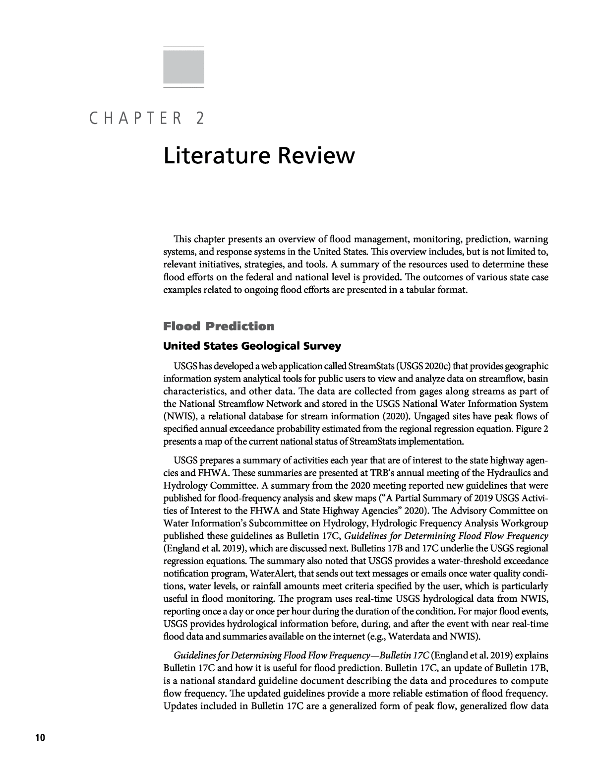
10 This chapter presents an overview of flood management, monitoring, prediction, warning systems, and response systems in the United States. This overview includes, but is not limited to, relevant initiatives, strategies, and tools. A summary of the resources used to determine these flood efforts on the federal and national level is provided. The outcomes of various state case examples related to ongoing flood efforts are presented in a tabular format. Flood Prediction United States Geological Survey USGS has developed a web application called StreamStats (USGS 2020c) that provides geographic information system analytical tools for public users to view and analyze data on streamflow, basin characteristics, and other data. The data are collected from gages along streams as part of the National Streamflow Network and stored in the USGS National Water Information System (NWIS), a relational database for stream information (2020). Ungaged sites have peak flows of specified annual exceedance probability estimated from the regional regression equation. Figure 2 presents a map of the current national status of StreamStats implementation. USGS prepares a summary of activities each year that are of interest to the state highway agen- cies and FHWA. These summaries are presented at TRBâs annual meeting of the Hydraulics and Hydrology Committee. A summary from the 2020 meeting reported new guidelines that were published for flood-frequency analysis and skew maps (âA Partial Summary of 2019 USGS Activi- ties of Interest to the FHWA and State Highway Agenciesâ 2020). The Advisory Committee on Water Informationâs Subcommittee on Hydrology, Hydrologic Frequency Analysis Workgroup published these guidelines as Bulletin 17C, Guidelines for Determining Flood Flow Frequency (England et al. 2019), which are discussed next. Bulletins 17B and 17C underlie the USGS regional regression equations. The summary also noted that USGS provides a water-threshold exceedance notification program, WaterAlert, that sends out text messages or emails once water quality condi- tions, water levels, or rainfall amounts meet criteria specified by the user, which is particularly useful in flood monitoring. The program uses real-time USGS hydrological data from NWIS, reporting once a day or once per hour during the duration of the condition. For major flood events, USGS provides hydrological information before, during, and after the event with near real-time flood data and summaries available on the internet (e.g., Waterdata and NWIS). Guidelines for Determining Flood Flow FrequencyâBulletin 17C (England et al. 2019) explains Bulletin 17C and how it is useful for flood prediction. Bulletin 17C, an update of Bulletin 17B, is a national standard guideline document describing the data and procedures to compute flow frequency. The updated guidelines provide a more reliable estimation of flood frequency. Updates included in Bulletin 17C are a generalized form of peak flow, generalized flow data C H A P T E R 2 Literature Review
Literature Review 11  as âinterval estimates,â an expected moments algorithm (EMA), and a standardized Multiple Grubbs-Beck Test. The National Streamflow Statistics (NSS) Program is a computer program that compiles all current USGS streamflow data from gaged and ungaged sites and uses regression equations to estimate flood-frequency statistics, including estimations of the magnitude and recurrence intervals for floods in urbanized areas. The National Streamflow Statistics Program: Estimating High and Low Streamflow Statistics for Ungaged Sites (Turnipseed and Ries 2007) reports the way NSS varies from StreamStats. NSS does not have the ability to generate flood frequency plots and flood hydrographs. This report describes the techniques used to develop regionalized equations for NSS and applicability and limitation of techniques. Regionalization of Surface-Water Statistics Using Multiple Linear Regression (Farmer et al. 2019) explains that the linear regression model is used to get information on streamflow when gages are absent from a location or are unmonitored. The model transfers collected information from gaged to ungaged locations. Using multiple linear regression models helps determine the streamflow frequency statistics. This method allows for the analysis and estimation of flood reoccurrence. Estimating Magnitude and Frequency of Floods Using the PeakFQ 7.0 Program (Veilleux et al. 2014) explains that to estimate the magnitude and frequency of flood discharges, flood-frequency analysis and data records from stream gages of annual maximum instantaneous peak discharges are used in conjunction with the calculation procedures of Bulletin 17C and the EMA. An estima- tion of magnitude and flood frequency is necessary to determine flood hazard areas, to manage floodplains, and to design flood-control structures. National Oceanic and Atmospheric Administration The National Weather Service is an agency within NOAA that provides NWS river forecasts. NWS has an interface available to the public on river forecasting called the Advanced Hydro- logic Prediction Service (2020). Figure 2. Status of StreamStats in the United States (USGS 2020c).
12 Practices for Integrated Flood Prediction and Response Systems NOAAâs Office of Water Prediction has led an inter-agency effort to develop the National Water Model (2020). The NWM is a hydrological modeling framework for simulating observed and forecasted streamflow in the United States. Using mathematical representations, the NWM simulates the complexity of the water cycleâs physical processes and how they fit together. The NWM generates hydrologic guidance at a fine temporal and spatial scale that can be helpful in supporting decision makers when a flood is threatening. This guidance will be produced at millions of locations that do not have NWS river forecasts, but it will also complement NWS river forecasts at approximately 4,000 locations across the United States. The NWM is currently on version 2.0 and produces 2.7 million river reach flow output points across the United States. Future work seeks to extend the length of the available river forecast system. Information from this service is available as a GIS webmap providing information for more than 3,700 storm gage locations across the United States. NOAAâs IFLOWS can be used to help states improve their flood warning capability (National Weather Service 2019). The main goals of the IFLOWS program include reducing overall property damage, loss of life, and dis- ruption to society and commerce activities. Multiple communities, counties, and state and federal agencies are linked into the communications network that uses IFLOWS technology. This Automated Flood Warning Systems (AFWS) network connects multiple local flood warning systems; the AFWS network shares and integrates information from 1,700 sensors located across 12 states. Federal Highway Administration An Every Day Counts (EDC) initiative weekly newsletter notes that agencies have modi- fied their traveler information systems as part of their weather-responsive management strate- gies in order to provide travelers with better flood data (2019c). For example, Houston TranStar, Houstonâs regional transportation management center, has coordinated with agency partners to develop flood thresholds to identify when to notify the public during an event. Once a threshold is exceeded, flood alerts are sent out to users, information is displayed on traveler maps, and travelers are encouraged to exercise caution or to avoid travel in specified areas where flooding is likely possible. The Iowa Department of Transportation has redesigned its 511 traveler informa- tion map closure icons in an effort to improve the publicâs understanding of major flood impacts. Transportation Research Board In âFraming the Challenge of Urban Flooding in the United Statesâ (Augustine and Linn 2019), the National Academiesâ Committee on Urban Flooding analyzed different dimensions of urban flooding through a workshop of different, representative metropolitan areas, such as Baltimore in Maryland, Houston in Texas, Chicago in Illinois, and Phoenix in Arizona. Each city experienced similar issues with the lack of current data on flooding hazards, including the social impacts and cost. The results of these workshops demonstrate that the public wants to understand the communityâs risk of flooding and the potential impacts from this flooding. It is suggested that maps, specifically GIS maps, be used because they are an easy, visual method of communicating this risk. This study also highlighted the current inefficiencies in having various levels of government being responsible for monitoring urban flooding, as it creates an over- complicated system. Instead, findings show that the responsibility of monitoring is shared in a multi-agency approach or cross-jurisdictional approach. American Association of State Highway and Transportation Officials The purpose of bridge management systems (BMS) is to help predict the future costs, offer alternative courses of action, and estimate performance of a bridge inventory. However, prioritizing projects according to BMS outputs is difficult. Therefore, âRisk Assessment for Bridge Management
Literature Review 13  Systemsâ (Thompson 2017) assesses NCHRP risk guidelines within a BMS, specifically AASHTOWare Bridge Management, to assist transportation agencies in estimating costs and benefits for mitigating bridge risk, replacing systems, and highlighting different consequences given 16 different scenarios. These guidelines will also help decision makers allocate and prioritize resources as they identify key national goals. University and Research Centers A presentation on â3D Flood Inundation Mappingâ for the NWC Inland Bathymetry Work- shop by the Center for Water and the Environment, University of Texas at Austin, explains flood inundation mapping with the NWM and the HAND (Height Above Nearest Drainage) method for determining flood risk (Maidment 2019). It explains that in the future, there needs to be a link between flood science and emergency response. Calculating flood inundation will allow the identification of the population, flooded roads, and homes affected. These inundation maps would be accessible both in the field and at the Emergency Operations Center. A study published in the Journal of the American Water Resources AssociationââA Hydraulic Multimodel Ensemble Framework for Visualizing Flood Inundation Uncertaintyââas part of the summer symposium demonstrates the advantages and uncertainties of using hydrometeor- ological ensembles and a hydraulic multimodal framework for visualizing and predicting flood inundation uncertainty (Zarzar et al. 2018). An ensemble of streamflow predictions from the regional hydrological ensemble prediction system can be created by applying HEC-RAS to the study area. Additionally, the iRIC (International River Interface Cooperative) software can be used to calculate the velocity and depth domains and to simulate flood extent over the study area. Overall, it was found that incorporating uncertainty into an interactive web application can allow for new techniques to rapidly disseminate flood prediction. The National Water Center Innovators Program Summer Institute Report 2016 by the Consor- tium of Universities for the Advancement of Hydrologic Science and the National Water Center contains 15 papers based on the preliminary outcomes of 12 research projects that leveraged NWM outputs (Maidment et al. 2016). The projects of the 2016 summer program focused on flood modeling, inundation mapping, forecast errors, and emergency response. The objective of all Innovators Programs is to create an âinnovation incubatorâ where diverse students can advance concepts and exchange ideas. These concepts and ideas are all related to the functioning of the NWM in the United States. Managing Critical Civil Infrastructure Systems: Improving Resilience to Disasters (Croope 2010) examines Marylandâs use of FEMAâs hazard vulnerability software program, Hazus-MH Flood, to analyze the impacts of the riverine and coastal flood risk across the state. The program used 100-year floodplain data, LiDAR topographic data, GIS building inventories, and block building data from the Census Bureau to provide comparable data across the state. The results of a 100-year storm show about 44,755 structures being damaged throughout Maryland, which amounts to large monetary losses. These results were comparable to other methods, such as the Compre- hensive Flood Management Grant Program, which were also discussed in this report. The report recommends other mitigation efforts for the state of Maryland, and workshops were used to demonstrate this system to planners and GIS specialists. Flood Monitoring and Warning Systems United States Geological Survey and National Oceanic and Atmospheric Administration ALERT2 is a new standard protocol that was meant to replace the original ALERT (Automated Local Evaluation in Real Time) produced by the National Hydrologic Warning Council (2019)â
14 Practices for Integrated Flood Prediction and Response Systems a national nonprofit organization dedicated to assisting emergency and environmental manage- ment officials by providing expert advice from a range of organizations, including NOAA and USGS. The updated version provides information quickly, abundantly, and without error about real-world events. Relating to AFWS and environmental monitoring, ALERT2 improves data collection capabilities. The benefits of ALERT2 include (a) error detection and correction to provide reliable data, (b) greater system capacity due to a tenfold quicker speed, (c) reduced processing times due to the use of time-division multiple access, (d) more site and senor identifiers, (e) unlimited message content, and (f) an option to extend protocol to allow cus- tomized messages. USGS has created programs that can be used to warn roadway safety division workers of current water conditions so that the correct safety implementation can be decided. USGS WaterAlert and WaterNow (USGS 2013) explain the automated systems for hydrologic data. WaterAlert is a notification program that sends emails or texts when exceedance flow occurs at USGS hydrologic data collection sites. This exceedance is the threshold criteria of water levels, water-quality conditions, or rainfall specified by users. WaterNow allows users to request reports of recent data collection values from any real-time USGS hydrologic data collection site through email or text. Transportation Research Board The contractorâs final report from NCHRP Project 20-59/Task 53, âFloodCast: A Framework for Enhanced Flood Event Decision Making for Transportation Resilience,â details that the California Department of Transportation (Caltrans) had identified the need for a âFloodCastâ alert system that would proactively monitor, access, and respond to flood-related disasters and events (Dewberry and Venner Consulting 2018a). The first phase of the FloodCast project identified available resources to support flood forecasting, response, and recovery through the FloodCast Technical Memorandum (Dewberry and Venner Consulting 2015). It recognized that many DOTs are interested in tools to assist with flood conditions, but few DOTs have mature models that can help estimate flood impacts. Additionally, the report highlighted that DOTs are interested in integrating flood forecasting tools with tools that will support emergency management and communication functions. An important gap was identified as the single-asset, single-issue focus of the most common transportation decision-making systems, because flood events are typically attributable to multiple incidents that may affect various interconnected assets. The report determined that five key elements are needed for robust flood forecasting and response framework: (a) meteorology, (b) hydraulics and hydrology, (c) asset management, (d) communication and information transfer, and (e) incident management. The second phase of the FloodCast project included the development of a prototype Flood- Cast system that used the five key elements that were determined in phase one (Dewberry and Venner Consulting 2018a). This system is documented in the FloodCast Practitioner Guidebook (Dewberry and Venner Consulting 2016) that was developed to help state and local DOTs and other transportation practitioners understand the tools and data applicable to flood response and hazard mitigation. The third phase refined the FloodCast prototype system and framework by developing a Capability Maturity Model (CMM) using the five key elements from phase one to help state DOTs define the key data, practices, and technologies required to effectively achieve floodcast- ing (Dewberry and Venner Consulting 2018a). A CMM Excel-based tool was created to allow DOTs to identify the current maturity level and a pathway to improve capabilities. By working closely with various state DOTs, it was possible to determine their concerns and needs related to the five key elements. A demonstration video was developed to showcase important data
Literature Review 15  elements, feature types, and relations in the FloodCast use case. Additionally, a standard set of attributes and specific formats for various DOT-owned assets needed to achieve FloodCast objectives was developed and is summarized in the FloodCast Data Standards and Specifications report (Dewberry and Venner Consulting 2018b). It was determined that a data gap that exists at locations along the stream networks without monitoring gages needs to be closed in order to improve the effectiveness of flood forecasting, response, and recovery efforts. Flood Response Systems Federal Highway Administration Communication is a key component of FHWAâs approach to flood response. FHWAâs Inno- vator bimonthly newsletter from January/February 2020 reported that pairing crowdsourcing for operations with weather-responsive management strategies can improve the impacts of both of these approaches. This method includes combining EDC approaches in order to accelerate success rates. For example, Wyoming DOT created the Road Condition Reporting application that can share information between its Traffic Management Center and maintenance vehicles, making it easier for its maintenance crews to report road conditions, traffic incidents, road hazards, and more. Wyoming DOT also uses crowdsource data in its 511 mobile application to improve real-time information on travel conditions while allowing users to submit real-world images to share with the public. Utah has also been using crowdsourced data to help fill any gaps that may exist in road weather information systems and to receive more timely and accurate weather forecasts. Lastly, Kentucky takes advantage of the data from third parties, like Doppler radar and Waze, so that its personnel can mix and match data to have a better understanding of a weather event. As a part of EDC, Collaborative Hydraulics: Advancing to the Next Generation of Engineering (CHANGE) (see Appendix E) states that two-dimensional hydraulic modeling software, graphi- cal interfaces, and supporting resources can be beneficial tools for understanding complex inter- actions between river or coastal environments and transportation assets (2019a). These models are typically used as to establish thresholds for flood management. This advancement in two- dimensional modeling was made possible by advancements in computer hardware, hydraulic modeling software, survey practices, and GIS. FHWA aims to provide the states with help and additional resources through its many programs and initiatives. For certain bridges or roads, establishing flood thresholds requires coastal hydraulics models, as opposed to riverine models. FHWA has created A Primer on Modeling in the Coastal Environ- ment (Webb 2017). It recommends including relative sea level rise (RSLR) in coastal models or riverine models with coastal downstream boundary conditions. Multiple methods for calculating RSLR exist, including methods described in the contractorâs final report for NCHRP Project 15-61, âApplying Climate Change Information to Hydrologic and Hydraulic Design of Transportation Infrastructureâ (Kilgore et al. 2019). FHWAâs Pathfinder case study outlines Coloradoâs Pathfinder process, shown in Figure 3. The process is used to strengthen relationships with the forecasters and weather impacts on roadways. This Pathfinder process includes (a) briefing reportsâinformation provided by forecasters (NWS, Colorado Avalanche Information Center, Iteris Inc.)âto Colorado DOT (CDOT) management, regional office staff, traffic operations, maintenance, and Office of Emer- gency Management; (b) a pre-storm conference where CDOT and Traffic Management Centers meet and deploy messages through CDOT and NWS; (c) implementation plan development (e.g., warning, alerts, maintenance plans); and (d) after-action reviews, which are shared with the Division of Emergency Management and Operations (FHWA 2018).
16 Practices for Integrated Flood Prediction and Response Systems FHWA works with local governments, state transportation departments, private industries, tribes, and other stakeholders to select innovations to enhance roadway safety, reduce traffic congestion, and shorten the project delivery process through its EDC initiative (Every Day Counts 2019c). FHWA claims the EDC program has had a great impact in building an innovative culture within the transportation community and accelerating the deployment of these inno- vations. Topic-relevant EDC innovations include collaborative hydraulics, weather-responsive management strategies, and unmanned aerial systems (UAS). Write-ups of these EDC innova- tions and more are available to the public on the FHWA website (Appendix E). A May 31, 2019, FHWA press release titled âFederal Transportation Officials Monitoring Storm and Flood Damage to Roads and Bridges in Midwestâ communicated that FHWA is assisting states throughout the Midwest to help with finances and to encourage them to use 511 systems to alert drivers during extreme events. These 511 alert systems will notify drivers of traffic jams, detours, and changing roadway conditions. Millions of dollars in âquick-releaseâ funding from FHWA is available each year to assist states in repairing critical transportation assets, to prevent additional future damages, and to help restore traffic and open rural routes. Structural road factors can be tested using nondestructive testing (NDT) like a falling weight deflectometer; however, they are not overly reliable. âDecision Tree for Postflooding Roadway Operationsâ (Qiao et al. 2017), funded by FHWA, proposed introducing uncertainty in the form of structural integrity post-flooding, structural NDT tests, and the Monte Carlo cost simula- tions using the Bayesian decision tree approach. The study suggests that using the decision tree method would allow transportation agencies to deal with emergency flooding situations more objectively, efficiently, and reliably. âFlooded Pavement Assessment Methodsâ (Sherwood 2017) was a study that planned to deliver a report containing short-term and long-term guidelines on assessing the conditions of flooded pavements. The goal was to identify the best time to reopen flooded roads to mini- mize pavement damage. Specifically, the author pinpoints a time in which emergency response vehicles can be permitted on the roadway post-flooding. Another goal was to create a model to identify the impacts of flooding on the long-term conditions, performance, and life of pavement. Decision-Tree Based Approach to Making Post-Flooding Road Opening and Closure Decisions for Transportation Agencies (Medina et al. 2016) used a decision tree approach to identify visual inspection needs and risks associated with the opening and closing of roadways for transpor- tation agencies. Factors like intensity of flood, location, roadway functional classification, and pavement cross-section characteristics were considered in the decision tree. This report surveyed approximately 40 different highway agencies on previous flooding events. An example study highlights that the benefits from the best decision are severely affected by the losses and conse- quences of opening the roadway too early (before good pavement integrity). Also, this example found that the in-place testing was only warranted given specific conditions in order to decrease the overall uncertainty in the results from the visual inspection of the roadway. Federal Emergency Management Agency Assessment of Evacuation Training Needs: Targeting Instruction to Meet the Requirements of Local Communities and Agencies (Ghimire et al. 2017) used an online questionnaire through Figure 3. Coloradoâs Pathfinder process (FHWA 2018).
Literature Review 17Â Â email and social media links to gather information on the evacuation needs of local areas throughout the United States. Results demonstrate that people generally agree that having an evacuation plan is important; however, responses on the presence and importance of this plan vary depending on the hazard. For instance, about 57% of the 727 responses have flooding plans (21% unsure) and rate them at an importance of 8.4 (on a scale of 1 to 10) on average. The evacu- ation training needs of each region were also ranked. These needs vary for different threats. In particular, emergency response training related to the special-needs population and warning/ alert systems were emphasized across a variety of hazards. Public Assistance: Preliminary Damage Assessments (FEMA 2015) outlines the Preliminary Damage Assessment (PDA) used by FEMA and local, state, and other regional partners in order to determine the severity of extreme storm damage and its resulting impacts. This assessment starts with the extreme event occurrence, after which local agencies assess and gather information on the damage. Next, state-level agencies verify the accuracy and completeness of the information collected by local agencies. Sometimes, if the event is severe enough, a joint PDA is formed. Within about a month of the event, the state or tribe must decide whether it believes federal assistance is needed. Federal assistance comes in the form of FEMA Individual Assistance, Public Assistance, and more. American Association of State Highway and Transportation Officials AASHTOâs Extreme Weather Events presentation on DOT lessons learned from the Resilient and Sustainable Transportation Systems Program suggests that DOTs should develop close rela- tionships with their first responders and state police to be better prepared for extreme events (Savage and Flood 2017). It also addresses the idea that new approaches to enforcing road closures may need to be developed and that tracking equipment with GPS can have a major impact on the response to extreme events. With regard to external communication, the presentation suggests that the impacts of extreme events should be available and reported to the public, including how the event was addressed and the next steps that are being taken. AASHTOâs âExtreme Events 101: Heavy Rainfall and Floodingâ of the âExtreme Weather and the Transportation Systemâ (2019) is a part of AASHTOâs Extreme Weather 101 Brief Program meant to provide high levels of information on common extreme weather events. The brief indicates that regional trends in flooding have not always followed trends in heavy rainfall. Flooding trends can be influenced by (a) rainfall during a one- or two-day period, (b) antecedent rainfall, (c) soil moisture, (d) changes in land surface, and (e) the installation of structures that affect streamflow. Future trends expect heavy rainfall to continue and become more frequent and intense with time. Three state DOTs were noted along with their involvement with addressing these flood events. Maine DOT, as a part of the Sustainability Solutions Initiative, is creating decision-making tools to help map culvert locations, schedule maintenance on assets, resize culverts if necessary, and analyze replacement needs and costs. Washington State DOT, as part of the FHWA Climate Resilience Pilots, is the first state to conduct a statewide vulnerability assessment. The state was in the assessment phase at the time this information was published. Minnesota DOT, also a part of FHWAâs Climate Resilience Pilots, is developing a vulnerability assessment to measure the sensitivity of the stateâs trunk highway system to flash flood events where it will focus on adaption options at high-risk facilities. All of AASHTOâs Extreme Weather 101 Briefs provide examples of how metropolitan planning organizations and state DOTs are effectively responding to extreme weather events. Transportation Research Board NCHRP Synthesis 497: Post-Extreme Event Damage Assessment and Response for Highway Bridges compiles information about technologies available for rapid post-extreme event damage
18 Practices for Integrated Flood Prediction and Response Systems assessment of highway bridges (Alipour 2016). It determined that 24 states were affected by the flood/debris flood hazard type. The survey showed 86% of the states claimed to have an emergency response plan in place, but that not all of them are tailored to bridges. This result showed that there is room for improvement in the emergency response plans as some of them only cover the mecha- nisms of receiving funding after an event. For an effective planning tool, response and recovery must be prioritized to guide decision making and minimize unintended consequences. NCHRP Synthesis 454: Response to Extreme Weather Impacts on Transportation Systems looks at eight diverse cases related to weather events and analyzes all of them using the same framework (Baglin 2014). The goal was to describe operations and infrastructure responses to extreme weather events at the state level, and to identify common themes within these responses. The notable events included in the synthesis related to the topic of flooding are (a) Hurricane Sandy in 2012, (b) river flooding in Iowa in 2011, (c) intense rains and floods in Tennessee in 2010, (d) intense rains and floods in Washington State in 2007, and (e) Tropical Storm Irene in Vermont in 2011. TRBâs Roadway Flash Flood Warning Devices Feasibility Study focuses on looking into using active systems to automatically warn motorists of hazards through variable message signs (Boselly 2001). This approach may also include active systems that could close roads with physical barriers, if necessary. These systems are important because few motorists understand the real danger of entering a flooded roadway. Current systems include both passive and active warning systems, but none prevent the motorist from entering the hazardous area. Often, high- way maintenance and emergency crews place barricades across hazardous roadways, but motorists commonly ignore them. Developing a system that automatically closes roads may have cost and durability concerns. Knowing this, the project team designed a proposed warning system that will include the data accessibility, alerting, warning, traffic control, and durability required for a successful system. University and Research Centers Analysis of Flood Vulnerability and Transit Availability with a Changing Climate in Harris County, Texas (Pulcinella et al. 2019)âsupported by the Center for Transportation Equity, Decisions and Dollarsâdiscusses early identification of areas vulnerable to flooding in order to become more efficient in evacuating people during extreme storms. It analyzed the impacts of these precipitation events on the vulnerable areas within the 100-year and 500-year FEMA floodplains in Harris County, Texas. These floodplains were exaggerated using the greatest Category 5 storm tide and predicted rise in the global sea level. Each GIS map included (a) a digital elevation model, (b) FEMA National Flood Hazard Layer, (c) storm tide inundation with sea level rise (SLR), and (d) demographic and transit information in order to analyze the trans- portation infrastructureâs ability to meet all of the areaâs demand under storm conditions. Results demonstrated that 70% of the densely populated areas, particularly those with low-income resi- dents, were vulnerable. This study concluded that new transportation infrastructure studies and evacuation strategies will need to be analyzed. âVulnerability Assessment during Mass Evacuation: Integrated Microsimulation-Based Evac- uation Modeling Approachâ (Alam and Habib 2019) created evacuation plans during extreme flooding events for vulnerable areas, like the Halifax Peninsula. These plans assessed vulnerabilities and socioeconomic factors, such as the number of cars owned in the region, general residence location, and land use. These components were also supported by an urban systems model, flood risk model, and dynamic traffic assignment model. The vulnerability assessment also used a Bayesian Belief Network modeling approach, which uses the information gathered from each of these models to generate different evacuation situations. Results from this study highlight the high vulnerability within the Halifax Peninsula regarding mobility due to poor clearance time. The social vulnerability was also found to be linked to the presence of the elderly or women.
Literature Review 19  Disaster Management (Elliot 2019) analyzed 19 different response systems focused primarily on communication structure and emergency announcement use across 11 countries. The results of each of these case studies demonstrate the importance of relevant, accurate information and of communication between organizations to disaster management capabilities. It suggests sharing knowledge through social networking services and using âself-helpâ measures to improve plan- ning, community resilience, and response to disasters. Evaluation of the Traffic Impacts of Mass Evacuation of Halifax: A Flood Risk and Dynamic Traffic Microsimulation Modeling (Alam et al. 2018) focuses on analyzing various flood sce- narios and how they affect the mass evacuation of the given area. The goal of this study is to assist emergency responders and decision makers in planning their evacuation routes, timing, and availability effectively. Potential flooding scenarios were tested through the creation of a spatial flood risk model and then the evacuation was simulated using a dynamic traffic microsimula- tion model. The paper used the Halifax Peninsula within Nova Scotia as a case study. Results demonstrated that 7.9 m of flooding was the maximum the infrastructure could handle and that prioritizing evacuees in a staged evacuation is the best response method. âModeling the Flooding Impacts of Hurricane Florence in Hampton Roadsâ (Fogel 2017) discusses the impacts of Hurricane Florence on the community of Hampton Roads. The data gathered from this flood event will be used to further improve the two-dimensional hydro- dynamic model. This model is being used by the Virginia Department of Transportation (VDOT) to predict the effects of flooding on about 500 bridges and culverts in the area. The goal of this model is to improve the resiliency of transportation assets in the region. Transportation Infrastructure Flooding: Sensing Water Levels and Clearing and Rerouting Traffic Out of Danger explains that flood prediction, road closure messages, and rerouting were developed to help increase resilience of transportation operations during flooding and to mitigate the danger to drivers and vehicle-related property damage (Murray-Tuite et al. 2017). The study provides a traveler assistance framework for use in a connected vehicle environment and in conjunction with high-resolution weather and road flooding prediction systems. This framework helps provide guidance to vehicles that were identified as being susceptible to the flood. The study suggests that improvements to the system could include new ways to identify and search for new destinations to reduce computation times. Lastly, larger amounts of data can also be collected to improve the flood predictions with automated flood observations. âRisk Factors for Driving into Flooded Roadsâ (Drobot et al. 2007) was completed to deter- mine why people drive into flooded roads, or to determine the risk factors. Survey questions were given to people in Denver, Colorado, and Austin, Texas. On the basis of regression models, the study concluded that the risk factors in determining whether someone would drive into flooded roads were his or her knowledge of the danger of flash floods and vehicles, age, and (specifically in Denver) previous experience with floods. These conclusions give recommenda- tions for agencies, including NWS, to incorporate more educational efforts for the public to understand weather warnings. Furthermore, the research reinforces the need for more road warnings on weather conditions, such as flooding. Planning for the Future Federal Highway Administration The Transportation Engineering Approaches to Climate Resiliency (TEACR) Study by FHWA (2019) includes Adaptation Decision-Making Assessment Process (ADAP) (FHWA 2016) and Synthesis of Approaches for Addressing Resilience in Project Development (Choate et al. 2017). The ADAP is a tool for both designers and planners that can help account for climate change
20 Practices for Integrated Flood Prediction and Response Systems roles in civil engineering project designs. The ADAP can be used either to design new infrastruc- ture projects or to assess a current assetâs sensitivity to climate change. If the ADAP is to be used for new projects, it is recommended that it be applied during the planning stages to gain the most benefit out of exploring alternatives. The risk-based tool can also be used to help decision makers choose between project alternatives for resiliency, life-cycle cost, and more. Even though the ADAP framework consists of specific steps, the process is meant to be molded and adjusted to fit unique situations or agency requirements. The study Resilience Overlay to Weather Capability Maturity Framework (Pisano and Alfelor 2019) reviews comprehensive checklists for transportation system operations, maintenance management, and emergency management. These checklists will help communities prepare for severe storm events and their potential impacts. This presentation also analyzes a capability matu- rity framework, which helps agencies evaluate and then improve their transportation network operations through the ability to prioritize and justify projects on the basis of vulnerabilities from a thorough and logical assessment of the network. A comprehensive study on protection of infrastructure (e.g., bridges) and understanding human influences of flooding examines historical trends in peak flow throughout the United States. âEffects of Climate, Regulation, and Urbanization on Historical Flood Trends in the United Statesâ (Hodgkins et al. 2019), funded by FHWA, analyzes the trend magnitude and direction of annual peak flow of separate basins by characteristics with influence on peak flows: minimally altered basins, regulated basins, and urbanized basins. It concluded that (a) mini- mally altered basins have a low percentage of significant increases and decreases in peak-flow magnitude, (b) regulated basins had significant decreases, and (c) urbanized basins had a high percentage of increases concentrated in the Northeast and Midwest. For all basins, the North- east had a high concentration of large and significant increases, and the Southwest had a high concentration of large significant decreases (basin regulation led to decreases). Hydrology and statistic models are incorporated into computer-aided programs, such as StreamStats and the National Streamflow Statistics Program, for state DOTs to use to predict rising flood conditions on and around roadways. âSeasonality of Climatic Drivers of Flood Variability in the Conterminous United Statesâ (Dickinson et al. 2019), funded by FHWA, explains that climate change causes flood variability, which affects the frequency of flood- generating precipitation, causing major economic and social concerns. Understanding the drivers of climate change can help determine locations prone to flooding. Research of correla- tion with climate indices has determined that floods are most affected by global-scale climate in the western and southern United States. FHWAâs Sustainability Resilience Pilots (Appendix E) are developed through partnerships with state DOTs, metropolitan planning organizations, and others. Namely, the 2013â2015 Pilot Program, âVulnerability Assessments and Adaptation Options,â aims to assess vulnerability in transportation and to evaluate options for improving transportation resilience. These programs include climate and extreme weather vulnerability studies and resilience plans for various states, with notable pilot projects discussed (Table 1). FHWA published Synthesis of Approaches for Addressing Resilience in Project Development (Choate et al. 2017), which synthesizes innovations and lessons learned from FHWA pilots and studies related to extreme weather events and climate change conditions on transportation assets. The synthesis aims to aid in the integration of these considerations into design projects by providing basic information on economics and climate science. The report also gathered useful information on how to integrate these climate considerations into project development and engineering design projects. Project-level studies were also surveyed for information, including climate sensitivities, adaptation options, lessons learned, and knowledge gaps. Those include Sandy Recovery projects, Gulf Coast Phase 2 projects, and TEACR case studies.
Literature Review 21Â Â State Notable practice Alaska (2016) In Alaska Climate Trend Vulnerability Study, three forward-focused case studies were conducted. It determined that precipitation in northwestern Alaska is projected to increase by about 15% to 30% based on estimates by the National Climate Assessment. NOAA predicts storm surges of 10 feet or more, with some parts of western Alaska seeing as high as 13-foot surges. To consider possible climate changes and uncertainties, the U.S. Department of Transportation developed a General Process for Transportation Facility Adaptation Assessments (the Process). This 11-step framework considers climate change and is used to determine best methods for decision making at the project level (Armstrong and Lupes 2016, FHWA-WFL/TD-16-001). Florida (2014) Hillsborough County MPO: Vulnerability Assessment and Adaptation Pilot Project analyzes sea level rise, storm surge, and inland flooding for Hillsborough County, Florida. USACEâs SLR projection methodology was used along with tide gage data and sea level trends from the NOAA Center for Operational Oceanographic Products and Services. The GeoPlan Center used the methodology to develop the Sea Level Scenario Sketch Planning Tool. Storm surge was analyzed using NOAA models. Storm surge with sea level rise was also developed using SLOSH (sea, lake, and overland surges from hurricanes) depth with the Sea Level Rise Tool developed by the Tampa Bay Regional Planning Council. Inland flooding was looked at using official 100-year floodplain maps. FEMAâs official Digital Flood Insurance Rate Map) was obtained for information on local flood zones, base flood elevation, and floodway status for a particular location. Hot spots were also determined based on the countyâs Engineering and Construction Service Section using multiple factors. The team used FHWAâs vulnerability assessment framework in a GIS platform to conduct the assessment of transportation assets (DeFlorio et al. 2014, FHWA). Iowa (2015) The âFHWA Climate Resilience Pilot Program: Iowa Department of Transportationâ (Claman and Lupes 2015) worked to improve transportation network resilience in storm events. In Iowa, this program is used to help evaluate the vulnerability of bridges and roads to river flooding. This study involved collecting data on vulnerable assets and climate, modeling streamflow, estimating future floods, and analyzing the credibility of the results. These findings will then be integrated into BridgeWatch, which is used to monitor the overtopping of bridges and roadways. BridgeWatch will be used in conjunction with USGS gages and NEXRAD (Next-Generation Radar) to alert engineers when bridges should be closed because of incoming storms or the likelihood of failure. Iowaâs Bridge and Highway Climate Change and Extreme Weather Vulnerability Assessment Pilot discusses projected streamflow statistics that were integrated with Iowa DOTâs bridge and roadway asset infrastructure database to assess vulnerability. The rating curves were developed using USGS gage data, when available, or USGS regression equations. NOAA Stage IV precipitation analysis was used to obtain accurate streamflow simulation. It is noted that the online USGS climate projection rainfall data sets are cumbersome. However, the main challenge is to figure out how to analyze multiple climate scenarios in a justifiable mannerâsince the existing design process is also cumbersomeâwhile using multiple streamflow data series at a single location. The main recommendation is to ensure that DOTs incorporate flexibility in their design analysis (C. Anderson et al. 2015, FHWA SPR HEPN-707). Maryland (2014) Maryland State Highway Administration (SHA) looked at the vulnerability of assets to climate stressors, including increase and decrease in precipitation, sea level change, and more in Climate Change Adaptation Plan with Detailed Vulnerability Assessment. LiDAR information from Maryland and Hazus modeling were used to develop predictive models. Vulnerability assessment for bridges was determined using U.S. Department of Transportationâs Vulnerability Assessment Scoring Tool and for roadways using the Hazard Vulnerability Index. It was determined that sea level change, storm surge, and increase precipitation would have the greatest impact on Marylandâs assets (Maryland SHA 2014, FHWA). Massachusetts (2013) Massachusetts DOTâs project team used the ADCIRC (advanced circulation) hydrodynamic model along with the SWAN (simulating waves nearshore) model to simulate storm-induced waves in agreement with hydrodynamics. They call this model the Boston Harbor Flood Risk Model (BH-FRM), which was determined to be good at simulating important coastal storm impacts. This model was able to identify potential flood locations and determine flood entry points and pathways. Scenarios were developed to simulate sea level rise along with the impact of hurricanes and norâeasters for the time periods selected. A Monte Carlo statistical approach was used to develop depth of flooding information for tens of thousands of locations, flood pathways and sources, detailed time-varying inundation maps, and the probability of flooding in the future. It was recommended that high-resolution hydrodynamic modeling be used in heavily populated areas with critical transportation infrastructure. Additionally, GIS was deemed a very powerful software, but there are many challenges, including complexity Table 1. FHWA sustainability resilience pilots. (continued on next page)
22 Practices for Integrated Flood Prediction and Response Systems State Notable practice and lack of expertise. The team also emphasizes the importance of considering the timing of the storm relative to the tidal cycle and also recommend not relying solely on automated digital data since local conditions cannot always be captured by them (Miller and Lupes 2013, FHWA). Minnesota (2014) In MnDOT Flash Flood Vulnerability and Adaptation Assessment Pilot Project (B. Anderson et al. 2014, FHWA), flood risk within Minnesota was evaluated using FHWAâs Climate Change and Extreme Weather Vulnerability Assessment Framework to improve the resiliency of transit systems currently vulnerable to flooding. This framework is presented in Figure 4. All vulnerable assets were given vulnerability scores based on sensitivity, exposure, and adaptive capacity metrics found using GIS analysis, hydraulic analysis, MnDOT databases, and work sessions. These scores then allowed MnDOT to rank its assets from tier 1 to tier 5, with tier 1 being the most vulnerable to flooding and tier 5 being the least vulnerable to flooding. Figure 4. FHWAâs Climate Change and Extreme Weather Vulnerability Assessment framework (FHWA 2012). Texas (2015) The North Central Texas Council of Governments created an assessment of extreme weather and climate impacts on infrastructure assets in North Central Texas through FHWAâs Resilience Pilot Program. In general, it predicted the likelihood of an increase in the number of days of severe thunderstorms by the end of the century. These predicted storms will likely increase severe flooding and therefore erosion and runoff. FEMAâs 100-year floodplain maps were also used to identify transportation assets vulnerable to flooding in severe precipitation events. Critical roadways were determined by overlaying this floodplain map on the location of assets with high annual average daily traffic per travel lane based on the Mobility 2035 Planâ2013 Amendment. The team recommends the use of three-dimensional models (like LiDAR) to significantly improve the assessment of critical infrastructure vulnerable to severe flooding and make results more spatially explicit and reliable (Winguth et al. 2015, FHWA). To determine the vulnerability of transportation assets in central Texas, data were collected and organized in a GIS in Central Texas Extreme Weather and Climate Change Vulnerability Assessment of Regional Transportation Infrastructure. Interviews were conducted with local experts to determine the climate variables to include in the vulnerability assessment. The team also used academic research to generate projections using the Weather Research and Forecasting regional climate model. For increased extreme precipitation, a hydrological model that is currently used by the City of Austin Flood Early Warning System (FEWS) was applied to simulate the future potential flood conditions for critical transportation assets. Vulnerability assessments were conducted using the U.S. Department of Transportationâs Vulnerability Assessment Scoring Tool, which was adjusted later based on feedback from state, regional, and local officials and experts. Lessons learned include the realization that inland extreme weather conditions may differ greatly from those that coastal communities face; this factor should be considered in asset management frameworks and in emergency response plans. Additionally, assets that were identified as critical may not be the most vulnerable, since local and county roads may have a greater sensitivity to extreme weather (Cambridge Systematics Inc. 2015). Table 1. (Continued).
Literature Review 23  Which assets are critical to assess climate change effects (e.g., flooding) is debated throughout many DOTs; these assets may include data-collecting systems, such as intelligent transportation systems (ITS). âAssessing Criticality in Transportation Adaptation Planningâ (FHWA 2011) is an outline of a draft conceptual manual that provides DOT agencies with information to systematically assess vulnerable transportation resources. Three components of vulnerability are exposure, sensitivity, and adaptive capacity. The challenges with assessing criticality are (a) the definition of criticality, (b) definition of the boundaries, (c) the time-consuming assess- ment, (d) the difficulty of integrating information, and (e) the definition of an asset. First in determining criticality is defining whether the study is vulnerable by defining the purpose, iden- tifying primary and secondary audiences of study, and stating the actions the audience needs to take. Second, to determine whether an asset is critical, three questions must be answered: What is an asset, what is the area, and who defines significant losses? Figure 5 shows an outline of the vulnerability assessment. Federal Emergency Management Agency In response to past flooding events, damage assessments are conducted to determine future models and response decisions to events. âFTA, FEMA Sign Agreement Outlining Roles for Addressing Public Transit Needs Following Hurricane Sandy, Future Major Disastersâ (FEMA 2013) outlines the memorandum of agreement (MOA) that was signed by the Federal Transit Administration (FTA) and FEMA stating the responsibilities of the agencies to provide assistance in repairing and restoring transportation systems in areas of declared emergency or major disaster. Primary federal responsibility is FEMAâs for emergency preparedness, response, and restoration of major disasters. FTA has primary responsibility for preparedness, response, and recovery costs of major disasters that affect public transportation systems. The MOA is a part of the FTAâs Public Transportation Emergency Relief Program. Transportation Research Board When addressing climate resistance, DOTs do not always use formal sets of costâbenefit analysis tools. To fill in gaps in the costâbenefit analysis and decision-making tools used by Figure 5. Vulnerability assessment chart (FHWA 2011).
24 Practices for Integrated Flood Prediction and Response Systems DOTs related to extreme weather, a TRB NCHRP guidebook has been developed, titled Incorpo- rating the Costs and Benefits of Adaptation Measures in Preparation for Extreme Weather Events and Climate Change. This guidebook stresses the risk of detrimental outcomes related to more frequent and more intense extreme precipitation events that are projected due to a warming climate (Dewberry Engineers et al. 2020). State DOTs are tasked with finding ways to optimize limited resources after these events in order to rebuild and reinforce the infrastructure needed to support safety and the economy. NCHRP Report 525: A Guide to Emergency Response Planning at State Transportation Agen- cies can serve as a guide for state transportation agencies to assist them in planning for upgrades in their traditional activities and to integrate them with national emergency activities (Wallace et al. 2010). State transportation agencies should understand the need for consistency within procedures, relationships, protocols, and resources across emergency hazards. The guide is valued in helping these agencies and local counterparts assess their current emergency response plans and identify any areas in need of improvement. The two main guides included in the 2010 guide are the âDesign an Emergency Preparedness Programâ in Sections 3â5 and the âResource Guideâ in Section 6. American Association of State Highway and Transportation Officials AASHTOâs Center for Environmental Excellence provides Environmental Topics on its website as a source of information for policies, programs, case studies, resources, tools, and more related to each topic (2019). The Infrastructure Resilience topic (Appendix E) explains that an eight-step framework for transportation agencies to undertake adaptation assessment is included in NCHRP Report 750: Strategic Issues Facing Transportation (Meyer et al. 2014). FHWA also provides a guidebook that includes an outline and key steps to the process of assessing the vulnerability of transportation systems and assets. Numerous state DOTs and metropolitan planning organizations have already used this guideline through their climate change resilience projects. Guidance and methods of assessing coastal transportation assets that focus on sea level rise, storm surge, and waves are also available on the FHWA website. The overview recommends a tool to help agencies incorporate climate risk into design practices from NCHRP Report 750, which is a query-based tool that provides guidance for assets and is customizable according to the climate threat being considered. University and Research Centers Storm-Surge Flooding and Sea-Level Rise Effects on Evacuation Connectivity and Maximum Flow in Norfolk and Virginia Beach (Phoowarawutthipanich et al. 2019) focused on the effects that storm surges and rising sea level have on the evacuation of people in major storm events. In particular, this paper analyzes whether the Norfolk and Virginia Beach areas need to be evacuated earlier because of sea level rise. The potentially vulnerable areas were identified using the water level time series data collected by the U.S. Army Corps of Engineers alongside GIS data. The study considered two conditions: mean sea level in these areas plus the tide and wave effects and mean sea level in these areas plus the tide, wave effects, and a sea level rise of one meter. The impact of both of these conditions was analyzed through five trials of maximum flow analysis that demonstrated the possible maximum number of cars leaving the system if the directions of the roads were normal. Results from this study demonstrate the need for earlier evacuations of these vulnerable areas when considering sea level rise (the time frame varies by topological and geographic factors). In Recent and Future Outlooks for Nuisance Flooding Impacts on Roadways on the U.S. East Coast (Jacobs et al. 2018), the tidal flood vulnerability of roads in the eastern United States
Literature Review 25  due to sea level rise was evaluated. The data used to identify this risk include the FHWA High- way Performance Monitoring System, flood frequency maps, historic observations of tidal gages, and future projections of the durations and frequencies of annual minor tidal floods. Results identify approximately 7,508 miles of roadway and 400 miles of interstate roadways all across the East Coast of the United States that are currently at risk of tidal flooding. This risk will lead to worse road conditions, delays, and closures with higher severity tidal floods and with higher sea level rise. Data-Driven Method for Predicting Future Evacuation Zones in the Context of Climate Change (Xie et al. 2016) focused on developing a more reliable, climate change dataâdriven method of determining future evacuation zones. This report analyzes the relationship between geographic components, demographic components, historical hurricane data, evacuation mobility, and current evacuation zones using a decision tree and random forest within a Manhattan case study. Results demonstrate that the random forest method is more accurate; thus, it is suggested that this method be used to predict future evacuation zones for the 2050s and 2090s, given future sea level rise. State Agency Effort Information was gathered on existing flood prediction systems, flood monitoring systems, flood warning systems, and response systems that have been implemented by individual states. Table 2 presents a summary of these findings that were found on state websites and in other online sources. Common resources provided by states include 511 websites, social media (e.g., Twitter, Facebook), text and email subscription alerts/services, evacuation route websites, road weather information systems (RWIS), and interactive maps, which often provide traffic speeds, detour routes, road conditions, traffic conditions, and weather alerts. Appendix C contains the complete version of Table 2. International Studies Prioritization of Climate Change Adaptation Interventions in a Road Network Combining Spatial Socioeconomic Data, Network Criticality Analysis, and Flood Risk Assessments (Espinet and Rozenberg 2018) uses a mix of economic, risk reduction, and social factors to provide a method of ranking transportation system adaptations against climate change for Zambezia and Nampula Provinces in Mozambique. This study analyzes the impact of socioeconomic elements on current and future transportation infrastructure hazard risk. The results of this study highlight that road adaptations due to climate change should be focused on roads within coastal areas when factors like risk, network importance, poverty, agriculture, and fisheries are considered. In Vulnerability: Top-Level Performance Indicator for Bridges Exposed to Flooding Hazards (Tanasic and Hajdin 2017), scour at the substructure of the bridge was identified as the primary method of failure for flood-stricken bridges. This effect was demonstrated in a simplified, network-level method for managing and assessing bridge performance through vulnerability measurements directly related to flooding. Pavement Fragility Modeling Framework and Build-in Resilience Strategies for Flood Hazard (Lu et al. 2017) analyzed pavement segments that have experienced flooding, resulting patterns of failure, and the various factors that affect pavement performance in Serbia. This analysis was then used to generate a pavement fragility model framework. This study was performed in Ontario, Canada, and used the Mechanistic-Empirical Pavement Design Guide (AASHTO 2020) to mimic the
26 Practices for Integrated Flood Prediction and Response Systems State Topic area Description Alabama Monitoring/warning The Alabama Department of Transportation Intelligent Transportation Systems Strategic Business Plan states that the ALGO Advanced Traffic Management System is a software that manages ITS equipment (Greshman Smith and Partners 2016). Alabama Law Enforcement Agency publishes weather advisories with details of flood predictions determined by the NWS (Alabama Law Enforcement Agency 2019). Arizona Monitoring Arizona DOT (ADOT) developed a resilience program, Asset Management, Extreme Weather, and Proxy Indicators Pilot Project (ADOT 2020). Monitoring/warning The Arizona Flood Warning System is an interactive map for users to determine precipitation data and water level in tabular and graphical format (Arizona Department of Water Resources 2019). California Prediction A project has been created to protect the Embarcadero Historic District from likely sea level rise (Cardno 2020). Monitoring/warning The Commercial Wholesale Web Portal by Caltrans is a system that provides high-resolution weather, visibility, and environmental data to in-field ITS devices throughout the 12 districts (Caltrans 2020). ALERT (Automated Local Evaluation in Real Time) is NWSâs communications protocol, which is a reliable and low-cost way to transmit data in real time (Monterey County Water Resources Agency 2019). Review of State of PracticeâEvaluating the Performance of Transportation Infrastructures during Extreme Weather Events (Ibrahim-Watkins 2018) states that the methods used to predict large inundation events are effective in reducing repair costs and increasing safe evacuation, but more diverse methods are needed. The preliminary investigation in Flood Warning Alert Systems found that many states, like California, need a flood alert system that allows them to proactively monitor, assess, and respond to flood disasters in real time (Lissade 2012). Response A summary of DOT stormwater research (Currier et al. 2020) presented at the 2020 TRB annual meeting was conducted with support of the Office of Water Programs at Sacramento State. Colorado Monitoring/warning Flood Threat Bulletin is a webpage created by the Colorado Water Conservation Board that updates users daily on the current weather and flood conditions (Colorado Water Conservation Board 2020). F2P2 is a program run by the Colorado Mile High Flood District (MHFD) with Boulder County, National Hydrologic, from April 15 through September 30 that provides a public interactive ArcGIS webmap created by MHFD, NWS, and ArcGIS (Urban Drainage and Flood Control District 2020). Delaware Prediction DelDOT Gateway is DelDOTâs interactive map with 28 layers including prediction of sea level rise (DelDOT 2020). The Strategic Implementation Plan for Climate Change, Sustainability & Resilience for Transportation describes Delawareâs development of a strategic plan to promote resilience and sustainability in its transportation system (DelDOT 2017). Monitoring/warning Delaware has a statewide flood monitoring system of 10 hydrology gages with real-time water levels (DelDOT 2020). The Delaware Coastal Monitoring System is an alert system used to provide information to planners, emergency managers, and others about future coastal events (Delaware Geological Survey 2019). Idaho Monitoring The success of Idaho DOTâs successful flood monitoring systems is attributed to BridgeWatch and the Idaho Transportation Board Scour Committee. More information about the practices of Idahoâs DOT is discussed in Chapter 4. A Temperature-Based Monitoring System for Scour and Deposition at Bridge Piers (Carpenter et al. 2017) explains a project that tests a low-cost, simple methodology to continuously monitor streambed elevation changes that uses the natural oscillations of stream water temperature as a tracer. Table 2. Summary of state flood systems.
Literature Review 27Â Â State Topic area Description Illinois Monitoring/warning Using a deterministic approach, âAn Evaluation of Transportation Network Robustness against Extreme Flooding: A GIS Based Approachâ (Kermanshah and Derrible 2017) analyzed the ability of the New York City and Chicago transportation networks to withstand extreme flood events. Iowa Prediction Iowa DOT claims that BridgeWatch has allowed it to conduct successful flood prediction modeling. The Iowa Flood Centerâs flood prediction and Iowa Flood Information System have also contributed to Iowa DOTâs success. More information on Iowa DOTâs practices is included in Chapter 4. An Integrated Framework for Risk and Resilience Assessment of the Road Network under Inland Flooding (Zhang and Alipour 2019) analyzes the vulnerability of a regionâs transportation infrastructure through running network-wide topologic assessments and flow- based risk assessments. Real-Time Flood Forecasting and Monitoring System for Highway Overtopping in Iowa is currently research in progress related to Iowa DOTâs flood monitoring and forecasting. The study includes attempting to interface the prediction of the hydrological model with BridgeWatch and information from sonic sensors developed by the Iowa Flood Center (Mantilla and Krajewski 2015). The hydrological model CUENCAS had been used to predict flooding in small tributaries in the Squaw Creek basin in Iowa. The goal of this project is to eventually develop a reliable real-time flood forecasting system to produce actionable results for those maintaining roadways during extreme flood events (Krajewski and Mantilla 2014). Monitoring/warning WeatherView is an interactive map by Iowa DOT that reports live weather conditions with data from Automated Weather Observing Systems and RWIS (Appendix F). The Iowa Flood Information System (IFIS) allows web-based access to flood-related information, visualization, and application (Iowa Flood Center 2019). The website, presented in Figure 6, provides easy access to links of flood alerts, stream conditions, river communities, and inundation maps. Figure 6. IFIS interface (Iowa Flood Center 2019). âScour Management in Iowa Using Modified HYRISKâ (Morshedi et al. 2018) discusses a tool, HYRISK, that was developed by FHWA to prioritize bridges on the basis of scour level. âClimate Change Impact on Highway Bridges: Flood-Induced Bridge Scourâ (Fioklou and Alipour 2017) analyzed the costs and benefits of five potential countermeasures to decrease the risk of bridge failure from scour in an old Iowan pilot study on U.S. 30 over the South Skunk River. Response As a part of its weather-responsive management strategies, Iowa DOT redesigned its 511 traveler information map where it improved its traditional closure icons and added painted lines to show the extent of closures, construction, and other applicable events (FHWA 2019a). Table 2. (Continued). (continued on next page)
28 Practices for Integrated Flood Prediction and Response Systems State Topic area Description Kansas Monitoring/warning The Kansas KDOT Transportation Operations and Management Center is the department that provides flood warning to the public through activation of the traveler information system (KDOT 2020). Developing a Bridge Scour Warning System explains that the monitoring of bridge scour presents multiple challenges for bridge owners, including state DOTs, because it can be difficult to detect below water level. It was determined that a systematic statewide system for monitoring scour-capable events at bridges across the state would be the most beneficial (Young 2016). Kentucky Prediction The Kentucky Transportation Center and the Kentucky Transportation Cabinet worked together to assess the flooding vulnerability of the National Highway System in âAssessing Transportation Assets for Vulnerability to Extreme Weather and Other Natural Hazardsâ (Blandford et al. 2018). Monitoring/warning GoKY is the Kentucky Transportation Cabinetâs interactive map that provides users information on weather activity, traffic delays, alerts, digital message signs, and cameras. The map also provides information on snowfall interpolation (Kentucky Transportation Cabinet 2020). Louisiana Monitoring USGS HydroWatch is an interactive map of USACE river gages, USGS HydroWatch devices, movable bridges, and water body locations (LA DOT 2020). Maryland Current status of flood event Major hurricanes that hit the United States between 2017 and 2018 have caused much damage to areas because of their intense rainfall. Steps need to be taken to mitigate the impacts of intense rainfall events in order to decrease urban flooding (Galloway et al. 2018). Monitoring The Global Flood Monitoring System at the University of Maryland is an experimental system funded by NASA (Wu 2019). Massachusetts Prediction âA Hierarchical Approach for Prioritizing Adaptation Needs for Roads and Bridges Exposed to Coastal Flooding in the Broad Sound Area of Coastal Massachusettsâ (Barankin et al. 2018) looks to improve vulnerability assessment approaches, especially indicator- based approaches, through decreasing unpredictable/irrational decisions with a type of adaptation planning. Michigan Prediction The Michigan Department of Environment, Great Lakes, and Energy conducts hydrologic analysis and calculates flood and low discharges for the state of Michigan. The MiSWIM (Michigan Surface Water Information Management) System is an interactive map of hydrologic information (Department of Environmental Quality & Department of Natural Resources 2020). Mississippi Prediction âFlood Vulnerability Rating (FVR) for Sustainable Bridge Management Systemsâ (Durmus and Uddin 2017) offers a geospatial decision support system that prioritizes bridges that are particularly vulnerable to flooding because the current BMS framework lacks vertical underclearance criteria. âAnalyses of Storm Surge Induced Flood Risk in Coastal Areas of Mississippiâ (Thomas et al. 2017) examines the storm surge flooding vulnerability of the Mississippi Gulf Coast with the goal of finding a method to analyze and predict potential future flooding in order to improve area resilience. Response In a news release, the Mississippi DOT announced multiple closures in anticipation of Pearl River flooding and that it has taken precautions and staged traffic control devices in areas where flooding is anticipated (MDOT 2020). Missouri Response Missouriâs Department of Public Safety released a Flood Damage Assessment Packet in 2019 to assist during major floods (Missouri Department of Public Safety 2019). New Jersey Response The meeting of the Transportation Operations Task Force of the Delaware Valley Regional Planning Commission (DVRPC) noted that New Jersey DOTâs UAS (unmanned aerial system) current initiatives include structural inspections, emergency response assessments, traffic congestion management, aerial 3D corridor mapping, and watershed surveys (Transportation Operations Task Force 2019). Table 2. (Continued).
Literature Review 29Â Â State Topic area Description New York Monitoring/warning, prediction The New York State Department of Transportation (NYSDOT) uses NWS flood warnings and BridgeWatch. NYSDOT also uses StreamStats for flood prediction and is working on further developing its StreamStats usage. NYSDOTâs practices are discussed further in Chapter 4. North Carolina Monitoring/warning Strong relationships with various agencies have allowed North Carolina DOT (NCDOT) to develop and maintain its flood management and response systems. More information on NCDOTâs practices is provided in Chapter 4. Establishment of the Flood Inundation Mapping and Alert Network (FIMAN) (Dorman and Banerjee 2016). Response Hurricane Florence produced record-breaking rainfall across eastern North Carolina and parts of northeastern South Carolina, where more than 30 inches of rain was measured in several locations in North Carolina (Armstrong 2019). Bruce Siceloff, an NCDOT spokesperson, reported that more than 1,000 feet of pavement and protective dunes along the roadway will need to be replaced on NC 12 on Ocracoke Island. NCDOT expects to spend tens of millions of dollars more once all repairs are complete, because the cost of road repairs has already reached nearly $180 million after Florence (Stradling 2019). North Dakota Prediction Clearpath Weather is the interactive map of sensors across North Dakota, including NDDOT RWIS, NWS, and Federal Aviation Administration information (NDDOT 2020). Ohio Monitoring/warning Development of a Flood-Warning System and Flood-Inundation Mapping in Licking County, Ohio created a flood-warning network by upgrading a lake-level gage, reestablishing and adding stream gages to the existing network, delineating the flood-inundation boundaries, and developing an unsteady-flow model for NWS use (Ostheimer 2012, FHWA). Oklahoma Response Decision Support System for Road Closures in Flash Flood Emergencies developed a novel decision support system to predict threats on roadways and remotely turn on TADD (Turn Around Donât Drown) red lights or gates to close roads during dangerous flood emergencies (Collins et al. 2013). Pennsylvania Prediction The stateâs phase one extreme weather vulnerability study evaluates historic vulnerabilities, develops a framework to address the impacts of climate change, and assesses risks and priorities linked to vulnerabilities (Michael Baker International 2017). Monitoring Flood Monitoring for Scour Critical Bridges serves as a reference for Pennsylvania on how to document signs of distress on bridges and approaches that have been or have nearly been overtopped by flood water (Pennsylvania DOT 2015). A presentation by PennDOT on âMonitoring Scour Critical Bridges during Floods for Local Bridge Ownersâ explains the fundamentals of bridge scour, how to categorize how critical a bridge is, and stresses the prioritization of safety during all processes because flood waters can be very dangerous (2015). Response DVRPCâs Transportation Operations Task Force meeting noted the usage of the Pennsylvania Turnpike Commissionâs UAS Program to update aerial imagery (Transportation Operations Task Force 2019). Pennsylvania DOT (PennDOT) Asset Management Initiatives include a Transportation Asset Management Plan (TAMP), Pavement Asset Management System (PAMS), and Bridge Asset Management System (BAMS) (PennDOT 2017). South Carolina Prediction âSouth Carolina Flood Inundation Mappingâ is research in progress to determine how to use HEC-RAS two-dimensional rain-on-grid modeling software to provide real-time data maps (Lamm 2020, FHWA). The South Carolina Unit Hydrograph Method Applications Manual provides the latest updates and improvements on the South Carolina Unit Hydrograph Method (Meadows 2020, FHWA). South Carolina DOT (SCDOT) has an application spreadsheet that can be used for the South Carolina Synthetic Unit Hydrograph Method. Table 2. (Continued). (continued on next page)
30 Practices for Integrated Flood Prediction and Response Systems Response SCDOT collaborates with multiple agencies on their flood management systems while aiming to constantly improve communication efforts. SCDOT uses BridgeWatch, which provides various benefits to its flood system efforts. SCDOTâs practices are discussed further in Chapter 4. Governor Henry McMaster established the South Carolina Floodwater Commission in October 2018, which was a first-of-its- kind attempt to bring together all stakeholders and others in the nonprofit sector to address flooding issues as a team (Mullikin 2019). The commission aims to mitigate flooding in South Carolina and lessen its negative impacts on the economy (South Carolina Floodwater Commission 2019). Texas Prediction The Texas Department of Transportation (TxDOT) plans to use the NWM for flood prediction but is working on improving some flaws within the model. TxDOTâs notable practices include data storage, communication, and well-coordinated emergency management. More information on TxDOT practices is provided in Chapter 4. The Texas Natural Resources Information System is a data information system containing census data, data related to emergency management, natural resource data, and other socioeconomic data (2020). Streamflow Measurement at TxDOT Bridges: Final Report (Maidment et al. 2019) tested NWSâs National Water Model through the installation of 20 radar streamflow gages on bridges on or near Interstate Highway 10, which can help forecast flooding in real-time using water velocity and water level to find stream discharge in the HEC-RAS two-dimensional model. The Texas State Flood Assessment provides information on the flood risks throughout Texas, an estimate of the cost of flood mitigation, a review of responsibilities and roles related to flooding, and a summary of stakeholder views on future flood planning (Lake et al. 2019). The âCity of Austin Flood Early Warning System with GCM Inputs to Forecast Inland Flooding Conditionsâ (DeFlorio 2015) used the FEWS hydraulic model to predict the conditions of inland flooding in the city of Austin, Texas. Warning The winner of the Best Transportation Systems Management and Operations Project was Houston TranStar for its Roadway Flood Warning System. Because heavy rainfall is a concern for flooding in the Houston area, Houston TranStarâin coordination with the Harris County Flood Control Districtâs Flood Warning Systemâhas created a real-time flood warning system that alerts travelers in high- risk areas during a rain event (Son 2019). A screenshot of the Houston TranStar website is presented in Figure 7. Figure 7. Houston TranStar interface (2020). A Greater Houston Flood Mitigation Consortium (GHFMC) briefing document notes that the advanced Severe Storm Prediction, Education, and Evacuation from Disasters Center has developed local flood alert systems for multiple regions that are capable of using real-time rainfall data from radar to predict flooding in crucial locations (GHFMC 2018). State Topic area Description Table 2. (Continued).
Literature Review 31  Response A GHFMC briefing document explains that floodplain regulations should be enacted to protect the health and safety of the public. Any community that is part of the National Flood Insurance Program is required to meet its minimum standards (GHFMC 2018). Utah Prediction The Utah DOT (UDOT) Road Weather interactive map includes road condition forecasts, city forecasts, and current conditions (UDOT 2020). Monitoring/warning Citizen Reporting is a program through UDOT in which roadway users can report on current roadway conditions to enhance coverage of weather on roads (UDOT 2020). A visual representation of this change is presented in Figure 8. Figure 8. Weather Operations Program data input sources (Utah DOT 2020). State Topic area Description Vermont Prediction The Vermont Agency of Transportation (Vtrans) has created a Statewide Highway Flood Vulnerability and Risk Map of bridges, culverts, and embankments along the highway system (Vtrans 2020). Virginia Warning Computational Enhancements for the Virginia Department of Transportation Regional River Severe Storm (R2S2) Model illustrates that flooding caused by changing climatic conditions has major impacts on transportation infrastructure. VDOT has begun addressing this situation by creating a flood warning systemâ the R2S2 Model (Morsy et al. 2017, FHWA). Washington Monitoring Washington State DOT (WSDOT) strives to make its flood management systems more proactive than reactive. The DOT uses WatchList for monitoring critical locations during flood events. The practices of WSDOT are discussed further in Chapter 4. Wyoming Prediction Wyoming DOTâs DayWeather is a map of forecasted weather color- coded in zones by low-, moderate-, and high-impact weather expected (Wyoming DOT 2020). Table 2. (Continued). impacts of 36 different, extreme hydrological events on pavement in the area. Results demonstrated that the main factors affecting pavement damage, both long term and short term, were the flood loading, condition of pavement before flooding, interference by humans, and other climate factors and behaviors after flooding. To conclude, this report suggests building flood resilience strategies into the pavement in order to manage future flooding events. Damage to transportation networks from flooding can be detrimental to communities; there- fore, it is important to identify better methods for highlighting vulnerabilities. Sponsored by the National Natural Science Foundation of China, Analysis of Transportation Network Vulnerability under Flooding Disaster (Chen et al. 2015) offers an accessibility-based method to evaluate the vulnerability of these transportation networks according to the availability of different modes of transportation in a region. To prove the functionality of this model, this study used a case study in Hillsborough County, Florida. Inundated segments within this county were collected on ArcGIS and input into CUBE software under different flooding conditions to identify various flood travel times. The results of this analysis were then compared with the Hansen accessibility method, which demonstrated that the proposed accessibility-based model is easier to use and understand. Probabilistic Graphical Models for Flood State Detection of Roads Combining Imagery and DEM (Frey et al. 2012)âresearch sponsored by the International Graduate School of Science
32 Practices for Integrated Flood Prediction and Response Systems and Engineering, Technische Universität Münchenâexplains the digital elevation model (DEM) system, a system based on a probabilistic graphical model that was created to estimate the conditions of roads during floods. Information for the models is produced from GIS, remote sensing data, and DEM. Study results noted that DEM combined with image data improves the accuracy of the data results. Summary of Gaps The review of literature and state sources revealed various gaps that exist in implementing integrated flood response systems. Data gaps in stream networks without monitoring gages were identified. Closing these gaps will improve the effectiveness of flood prediction, response, and recovery efforts. There is also a lack of current data on flooding hazards, which includes costs and social impacts. The backwater and coastal zones have river modeling challenges. These coastal areas proved to be complex areas to model. More sophisticated modeling in coastal zones is needed for improved flood prediction. A need was also identified for more diverse methods for predicting large inunda- tion events. Another gap exists in integrating data across agencies where collaboration and com- munication are lacking. There is also a need to understand the density of information required for accurate predictions. Urbanization and land development result in more frequently observed intense runoff events. The highly dynamic nature of these areas makes flood prediction particularly challenging. To better mitigate the impacts of intense runoff events, research is needed to better predict the downstream impacts of urbanization and land development. A clear definition of responsibili- ties is needed among a wide range of stakeholders (e.g., federal, state, regional, local, and tribal governments) for stormwater management or urban flooding, even though local governments are primarily responsible for the mitigation of urban flooding. Improved communication systems and efforts are also needed within and between agencies. A gap was identified in the single-asset, single-issue focus of the most common transporta- tion decision-making systems. It is considered to be a gap because flood events are typically attributable to various incidents that can impact multiple interconnected assets. Transportation decision-making systems need to incorporate these incidents rather than focus on one asset or issue. It is suggested that NWS and other agencies incorporate more educational efforts toward the public and state agencies on understanding weather warnings.
