
APPENDIX A
Background and Linkages
WORLD CLIMATE RESEARCH PROGRAMME
The World Climate Research Programme (WCRP) was formed in 1979 to help develop the vast and diverse knowledge needed to understand the processes that determine climate and control climatic variations, and to develop methods to predict those aspects of climate variability or forced climate change that are indeed predictable. Since then, WCRP has become the principal international planning and coordinating mechanism for climate research throughout the world. WCRP has focused its effort on the physical climate system (atmosphere, ocean and sea ice, land surface hydrology, and continental glaciers or ice sheets), while a companion program, the International Geosphere Biosphere Programme (IGBP) emphasizes biological and chemical processes. The general objectives of WCRP are (1) to determine the extent to which climate can be predicted AND (2) to determine the extent of human influence on climate.
GLOBAL ENERGY AND WATER CYCLE EXPERIMENT (GEWEX)
Water in its various phases plays a dominant role in nearly all aspects of the Earth's climate system. Water vapor is the most powerful contributor to the greenhouse effect in the Earth's atmosphere and the main vehicle of atmospheric energy transport. As a liquid, water sustains life on Earth, is accumulated in enormous quantity in the world's oceans, plays a major moderating role in the Earth's climate, and distinguishes our planet from all others in the solar system. As solid ice particles in clouds or snow on the ground, it reflects solar energy
back to space. Condensation from vapor to liquid or ice heats the atmosphere, and evaporation cools the surface. To determine the net effect of water on our climate, the full cycle of evaporation, water vapor transport, cloud formation, precipitation, and runoff must be considered as an integral system, within which these "fast climate processes" interact on relatively short time scales, thereby involving large fluxes of energy. On the basis of this scientific paradigm, the WCRP formulated (WCRP, 1987) the concept of the Global Energy and Water Budget Experiment, an integrated multidisciplinary research program to study the interactions between the fast climate processes in the atmosphere and at the land surface, and the impact of these processes on exchanges of momentum, water, and energy with the slower components of the climate system.
GEWEX is an integrated program (Table A.1) to understand, model, and predict (1) radiative processed involving cloud, aerosol, water vapor, and their impact on radiation transfer and radiation flux divergence in the atmospheric column, and (2) hydrological processes, involving the transport and release of heat in the atmosphere, precipitation, evapotranspiration and land surface exchanges, groundwater storage, and runoff. GCIP is relevant to all elements in this program. The goal of GEWEX is to study and model linkages between the energy and water cycles on all time and space scales, using optimal combinations of in situ measurements and observations from space, especially the more informative data expected from the next generation of remote sensing instruments that constitute the International Earth Observing System (IEOS).
The overall objectives of the GEWEX program were expressed by WCRP as the following:
-
Determine the Earth's hydrologic cycle and energy fluxes using global measurements.
-
Model the global hydrologic cycle and assess its impact on the atmosphere, oceans, and land surfaces.
-
Develop the ability to predict variations in global and regional hydrological processes and water resources, as well as their responses to environmental change.
-
Foster the development of observing techniques and data management and assimilation systems suitable for operational application to long-range weather forecasts, hydrology, and climate predictions.
GEWEX is not an experiment in the traditional sense; rather it is an integrated program of research, observations, and science activities ultimately leading to prediction of variations in the global and regional hydrological regimes. Because of the magnitude of the effort, GEWEX is compiling information from several ongoing studies and will initiate investigations of its own, as needed, to improve modeling accuracy and the surface-atmosphere coupling in general circulation models. In fact, GEWEX initially encouraged a suite of exploratory
TABLE A.1 GEWEX Projects
|
Project Name |
Description |
Methodology |
Status or Products |
|
Hydrometeorology and Land Surface Processes |
|||
|
GEWEX Continental-Scale International Project |
Intensive study of hydrological and energy budgets in the Mississippi River basin from 1995 to 1999 |
Develop new coupled land-atmosphere regional models based on a comprehensive data base of the Mississippi River basin using radars, profilers, and surface observing systems |
• GIDS-1 CD-ROM (2/92–4/92) Atmospheric, hydrological, satellite, and radar composites; and surface data for central Mississippi River basin • GREDS CD-ROM—Topographic and land-use data • GIDS-3—GCIP integrated systems test data from Arkansas-Red River basin (on-line) |
|
Global Runoff Data Center |
Develop global streamflow data base for use in the development and verification of atmospheric circulation models |
Compile river discharge data from 3300 stations located in 140 countries |
• Daily and monthly flow data sets (on diskettes) • Gridded runoff data (in development) |
|
International Satellite Land Surfaces Climatology Project |
Provide global data, experiments, and modeling of land surface interactions, emphasizing satellite remote sensing |
Develop new satellite measurement techniques and algorithms, conduct field campaigns, and develop global data sets for use in interdisciplinary science investigations |
• 2-yr (1987–1988) global 1° × 1° land surface data sets • Updated data set for 1986–1995 at 0.5° × 0.5° planned for 1998 |
|
Regional Continental - Scale Experiments |
BALTEX, GAME, LBA, MAGS: Intensive studies of specific hydrological regions |
Improved observations and coupled land-atmosphere models |
Data sets and improved model outputs planned |
|
Project Name |
Description |
Methodology |
Status or Products |
|
Atmospheric Radiation Processes |
|||
|
Baseline Surface Radiation Network |
Provide highly accurate worldwide radiative flux measurements to validate satellite-based measurements |
Develop instrument requirements, establish BSRN reference stations worldwide, and assemble a data base |
• 12 stations reporting in 1995; 27+planned |
|
Global Precipitation Climatology Project |
Provide monthly global estimates of area-averaged precipitation |
Merge in situ daily gauge (6000 stations) with microwave and IR satellite land and ocean data into 10-yr global data set |
• 7 yr (1986–1993)—2.5° × 2.5° blended precipitation data set • 1987–1988 1° × 1° gauge-only data set (ISLSCP CD-ROM) |
|
GEWEX Water Vapor Project |
Improve measurement of water vapor, and accuracy and availability of global data |
Build global water vapor data set, establish reference stations, conduct intercomparison studies, and foster R&D for new RH RAOB sensor |
• 5-yr (1988–1992) blended global water vapor and cloud liquid water data sets • 10-yr data set planned for 1997 |
|
International Satellite Cloud Climatology Project |
Produce a continuous global data set of the Earth's radiance |
Collect and analyze satellite cloud radiance data from geostationary and polar orbiting weather satellites |
• 9-yr (1983–1991) global cloud products at 280-km resolution on CD-ROM • Updated 10-yr data set in process |
|
Surface Radiation Budget |
Produce a 10-yr global data set of the Earth's surface radiation budget |
Using ISCCP data and radiative transfer models, produce shortwave (SW) and longwave (LW) global data sets |
• 4-yr (1985-1988) SW data • 1983–1995 SW and LW data for 1998 release |
|
Modeling and Prediction |
|||
|
GEWEX Cloud System Study |
Develop new physically based cloud parameterizations based on cloud-resolving models of different cloud systems for NWP and climate models |
Develop models using existing and planned campaign data sets, conduct intercomparison workshops, and provide blueprints of cloud data requirements for new campaigns |
• WG1 data for case studies • WG3-CFRP data (11/84) • WG3-BASE data (9/91–10/91) • WG3-CASP II data (2/92) (all the above available via the WWW) |
|
Projects for Intercomparison of Land-Surface Parameterization Schemes |
Provide accurate land surface process parameterizations for climate models |
Validate land surface process parameterization schemes, and compare these to existing schemes |
Intercomparison phase 1, 2, and 3 results published in IGPO reports |
studies over relatively small experimental sites, involving intensive field observations and theoretical process modeling, such as the FIFE study organized by the GEWEX International Satellite Land Surface Climatology Project. As the understanding of small-scale aspects of the hydrologic cycle progressed, it became clear that the next scientific priority was to address interactions across the spectrum of spatial scales, the aggregation of processes from micro- or mesoscales to synoptic or planetary scales, and the inverse disaggregation of phenomena from the larger meteorological scales to the smaller scales that are meaningful to hydrological scientists.
GEWEX Hydrology Projects
The initial concept of the GEWEX Continental-Scale International Experiment, the first of a suite of continental-scale atmospheric-hydrological observation, data assimilation and modeling research projects (or experiments) fostered by GEWEX, was formulated in 1990 (WCRP, 1992). GCIP was originally conceived as a project that would continue until 2000 and then merge into a new phase of global atmospheric-hydrologic studies relying on expected new global satellite data sets. A principal scientific objective of GCIP was to measure, study and model coupled atmospheric and hydrologic processes on all intermediate scales between those captured by intensive field studies on various experimental sites, such as FIFE and BOREAS, and planetary scales that can be observed by global observing systems.
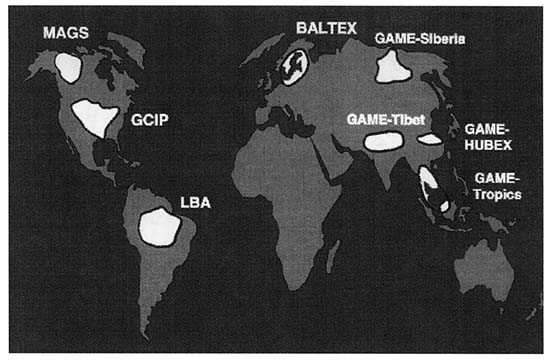
Four additional GEWEX continental-scale experimental projects now focus on the study of large-scale hydrological processes and closing the energy and water budgets over large land areas representative of various climatic regimes (Figure A.1). Currently, GCIP interacts most with the Mackenzie GEWEX Study undertaken by Canada over the almost contiguous Mackenzie River basin to the north. MAGS emphasizes cold season processes, such as snow and ice, permafrost, arctic clouds. The other continental-scale experiments are the Baltic Sea Experiment (BALTEX) in northern Europe, the Land-Biosphere-Atmosphere (LBA) project over the Amazon basin, and the GEWEX Asian Monsoon Experiment (GAME) covering several sites in Eastern Asia. A newly formed GEWEX Hydrometeorology Panel (GHP) has agreed that each continental experiment must satisfy the following criteria:
-
Cooperate with an NWP center that has implemented a state-of-the-art atmospheric and surface data assimilation procedure, and will deliver estimates of hydrometeorological properties in a form directly comparable to observations.
-
Commit resources and personnel to pursue the development of suitable atmospheric-hydrological models, develop an atmospheric-hydrological data management and assimilation system, and conduct an appropriate program of numerical experimentation and climate change studies.
-
Develop a regional scientific cooperation mechanism for collecting and managing hydrometerological data sets, including satellite observations, for supporting and validating the above model developments.
-
Participate in the international exchange of scientific information and data in conformity with the general practice of WCRP.
-
Collaborate with water resources agencies or related client-user groups to better utilize improved continental-scale information with the objective of addressing the problem of assessment of impacts on regional water resources.
An essential task of the continental-scale projects is to assemble the most complete and accurate data sets possible of hydrologic components over continental-scale areas, by combining rain and snow gauge measurements, Doppler radar observations, aircraft transects, and a variety of satellite remote sensing data. Net surface radiation and precipitation data will provide the means to test on a continental scale and improve the surface-vegetation-atmosphere transfer algorithms used in general circulation models, as part of the GEWEX International Satellite Land Surface Climatology Project, supported by NASA and other space agencies, to develop the applications of remote sensing to the characterization of soil-vegetation properties and exchange processes over land areas. The projects will also provide data to the global runoff data center, which is compiling the most comprehensive, ever, depiction of global streamflow discharge.
Radiation Processes
Continental-scale projects provide the opportunity to acquire special water vapor and cloud data sets derived from geostationary satellite observations that are available over continental areas with higher spatial and temporal resolution than are currently feasible for global climatologies. The same algorithms will be used by GEWEX Water Vapor Project and the International Satellite Cloud Climatology Project (ISCCP) to estimate statistics of water vapor and cloud distributions. A by-product of this effort will be mesoscale-resolving estimates of solar irradiance and net radiation at the surface, inferred from hourly or three-hourly cloud cover data using algorithms developed by the GEWEX Surface Radiation Budget climatology project and validated against precision measurements of solar radiation provided by the GEWEX Baseline Surface Radiation Network and other sources. The continental projects also offer the opportunity to validate and enhance global data sets being developed by the Global Precipitation Climatology Project.
Atmospheric And Hydrological Data Assimilation
The National Weather Centers, in cooperation with the GHP programs, are carrying out systematic four-dimensional assimilation of upper-air and surface
meteorological data with mesoscale resolution over continental areas. These data are providing an ideal setting for the future validation of cloud-resolving model simulations and cloud parameterization schemes, developed under the associated GEWEX Cloud Systems Study. Data from the continental experiments are also helping to foster land surface intercomparison experiments similar to the PILPS experiment currently being carried out over the Arkansas Red River basin of GCIP. Such intercomparisons are paving the way for land data assimilation methods that are just beginning in GCIP.
Pan-American Climate Study
PACS is a component of the U.S. GOALS research program aiming to improve the skill of seasonal to interannual climate predictions over the Americas. PACS emphasizes planetary-scale teleconnections and the seasonal to inter-annual variability of rain-producing weather systems, whereas GCIP focuses on the impact of these systems on land-vegetation-hydrology processes and the water budget of the region. The specific objectives of PACS are to improve predictive models of the ''monsoons" that bring substantial rainfall to the southwestern part of the United States and Mexico and to understand relationships between such seasonal circulation patterns, the position of the intertropical convergence zone, equatorial sea surface temperature anomalies, subtropical stratus cloud decks, and the dominant tropical and extratropical cyclone tracks. Specific attention is being paid to improving the coupling of the ocean and atmosphere in models and on the parameterization in these models of the air-sea fluxes of moisture and heat.
PACS looks to GCIP for support in the collection of data over North America and for improvements in the parameterization of land surface processes. More generally, GOALS will benefit from GCIP's improved understanding of the water and energy cycles over land. In addition, GCIP and PACS will foster joint empirical and modeling studies of summer atmospheric circulation patterns and associated hydrologic regimes over the North American continent. Wintertime patterns should also be considered.
Atmospheric Radiation Measurement Program
The Department of Energy has undertaken the ARM program to characterize, understand, and model radiation transfer and radiation flux divergence in clear and cloudy atmospheres. A central component of this program is the Cloud and Radiation Testbed (CART), a comprehensively instrumented site in the southern Great Plains. The CART site covers a 350 × 400 km area in the Red River catchment and lies within the Southwest large-scale study area of GCIP. The CART site provides surface radiation flux data at 18 locations within the site, together with boundary-layer soundings at 4 of the 18 locations. Measurements
are implemented with enhanced frequency several times a year during intensive observing periods (IOPs) lasting a few weeks in order to sample seasonal variations. The CART observations constitute a unique source of high-precision radiation and surface meteorological data in the region where GCIP studies of summer rainfall and reevaporation are focused. GCIP supported several additional observing projects at the ARM-CART site, including atmospheric boundary-layer flux measurements, during the summer IOP in 1994 and 1995, and contributed soil temperature and moisture instrumentation at the surface flux measurement stations within the site. ARM-CART and GCIP data are exchanged and made available to both scientific communities.
The scientific approaches are somewhat different in the ARM program and GCIP. Whereas ARM focuses on radiation transfer and, in general, the vertical structure of phenomena in an atmospheric column, GCIP emphasizes atmospheric advection and flux divergence, the horizontal distribution of land surface fluxes, and hydrologic processes. It is realized that both approaches provide essential and complementary insights into the global water and energy cycles. Radiation processes determine, in part, the vertical structure of atmospheric heating, which in turn influences mesoscale convective motions, the condensation and release of latent heat, and the distribution of precipitation. Surface net radiation is also the main source of energy that drives evaporation and the release of heat from the surface into the atmosphere. Soil moisture, vegetation, and the hydrologic properties of soil determine the partitioning of net radiative energy input into sensible and latent heat and ultimately control the temperature structure of the lower atmosphere. It is essential that the three-dimensional GCIP data assimilation and modeling strategy be combined with detailed ARM studies of phenomena at the surface and in a vertical atmospheric column in order to realize the synergy between the two programs. In particular, the ARM-CART measurements will provide a benchmark to test the accuracy of model-generated fields produced by GCIP mesoscale data assimilation projects, whereas GCIP will provide information on large-scale features such as atmospheric moisture and heat convergence over the CART site.
NASA MISSION TO PLANET EARTH (MTPE)
GEWEX articulates the international science strategy and scientific rationale for a large component of NASA-MTPE that is focused on the observation of atmospheric and land surface phenomena in the context of the study of the Earth's physical climate. NASA supports a variety of GCIP projects, including in situ field observations and aircraft or satellite remote sensing studies, in particular through the ISLSCP. NASA also provides data products and analyzed fields essential to the success of GCIP, notably diagnostics of cloud amount and properties through the ISCCP, surface radiation flux estimates (Langley Research Center), and soil-hydrology-vegetation data (Huntsville Global Hydrology and
Climate Center). Conversely, it is foreseen that GCIP multidisciplinary studies and data products will provide a high-quality benchmark for the validation of MTPE Earth Observing System observations in the forthcoming TRMM and AM-1 satellite missions. However, MTPE field programs within the Mississippi River basin should be encouraged during the GCIP climate experiment.
U.S. WEATHER RESEARCH PROGRAM
The U.S. Weather Research Program (USWRP) provides a research focus for the ongoing modernization of the National Weather Service. USWRP is attempting to improve the specificity, accuracy, and reliability of whether forecasts using the best possible mix of modern observations, data assimilation, and forecast models. In particular, USWRP's goal is to improve forecasts of high-impact weather for agriculture, construction, defense, energy, transportation, public safety (emergency management), and water resources management, including floods. USWRP is especially concerned with studies related to quantitative precipitation forecasting. These include the measurement, estimation and depiction of water vapor; the representation of convection in forecast models; and the estimation of precipitation amount and type by radar and satellite. USWRP has also begun to consider the control on extreme events by surface effects, including soil-vegetation and canopy. These weather prediction research efforts complement GCIP's regional climate activities. In addition, USWRP's studies related to quantitative precipitation forecasting will help GCIP understand how to make better use of NEXRAD products. USWRP is also beginning to coordinate its activities with the World Weather Research Programme, which is proposed to have formal linkages to GEWEX through the World Meteorological Organization in Geneva. It would be advantageous for the GEWEX and GCIP climate programs to develop links to these national and international weather prediction efforts, especially when expensive field experiments are planned.


