
1
Overview
Definition
A Vital Part of the National Infrastructure
For more than a century, public-spirited citizens all across the United States have performed an invaluable service by participating in a network of volunteer cooperative observers managed by the federal government. By donating their time and the use of their property to monitor temperature and precipitation amounts, these volunteers have provided the United States with one of the most comprehensive and complete records of temperature and precipitation anywhere in the world. The Cooperative Observer Network (Coop Network) is the nation's largest and oldest weather network. The data this network provides are vital to a myriad of policy and economic decisions made by industry, government, and individuals.
The Coop Network, as it is commonly called, was established in 1890 to make meteorological observations and establish and record climatic conditions in the United States, primarily for agricultural purposes (see Box 1-1). In response to the recent interest in climate change and variability, the Coop Network has taken on an additional mission—monitoring and detecting climate changes. Although the network was not designed for this purpose, it provides invaluable data. Because it has generated consistent, long-term historical climate data, the network has established an invaluable record of the climate in the United States (see Boxes 1-2 and 1-3).
Today the Coop Network is increasingly used by the National Weather Service (NWS) to support meteorological and hydrological forecasts and warnings and to verify forecasts. The Coop Network is the only nationwide source of data on surface precipitation and the only source of systematic observations of surface snow, which are critical for hydrological forecasting. Network data are used in applied hydrology (especially for long-term forecasts of water resources) and for research (e.g., the development and verification of mesoscale forecast models).
Coop data have been used in recent years for water management, drought assessment, engineering and architectural design, models of energy consumption, environmental impact assessments, environmental monitoring and prediction, litigation, and many other purposes (see Appendix B). Not surprisingly, the range of users has also expanded beyond farmers and government officials to encompass engineers, architects, attorneys, insurance companies, scientists, utility companies, manufacturers, and business planners. Indeed, the uses and users of Coop Network data mirror our society and economy. For example, more than one-fourth of all requests for coop data (which are legally certifiable in a court of law) now come from attorneys. Millions of small and large decisions, by public and private concerns, are based on coop data—when to plant corn, where to site power plants, where (and how) to build buildings or bridges, how many snow days to plan into the school year, how much road salt to buy, where to plan one's retirement, how much to limit emissions, and so on (see Box 1-4).
From any perspective, this little known, low-cost network is a vital element of the nation's infrastructure—arguably the most comprehensive national observing network for monitoring temperature, precipitation, snowfall, and other weather events in the United States.
Network Configuration
The Coop Network consists of thousands of volunteer citizens and institutions. Participants are provided with a set of simple weather instruments and observing instructions by the NWS, which manages the network under the Cooperative Observer Program (the Coop Program). The observers provide basic weather data for their locations, usually on a daily basis.
Within the Coop Network there are several types of stations (see Figure 1-1). At the heart of the network are about 5,000 full "climatological stations" that measure daily maximum and minimum temperatures, precipitation, snowfall,
|
BOX 1-1 Historical Roots of the Cooperative Observer Network
Source: NOAA, 1993. |
and temperature and snow depth at the time of observation. Many observers also provide supplemental information, such as time of day when the precipitation fell and other weather conditions, such as fog, freezing rain, thunder, hail, and damaging winds. These stations, called "A" stations by NWS officials, are operated predominantly by volunteers—either private individuals or employees of cooperating institutions, such as agricultural businesses, university research stations, reservoir caretakers, and water treatment plant operators. About 35 percent of the cooperative observers are paid a very small monthly fee (usually around $30) to cover personal expenses. Stations are located at universities, research centers, municipal facilities, farms, ranches, homes, and businesses. About 30 percent of stations are located at institutions that also use the local climatic data.
In the early years of the Coop Network, nearly all of the stations were full climatological stations. The number of Astations grew from about 1,000 in 1900 to 5,850 in 1972. In recent years, the number has dropped to about 5,000. In 1953, guidelines were developed for the network suggesting a target of one full climatological station for every 625 square miles. This target has never been reached, particularly in the sparsely populated regions of the western United States (see Figure 1-2).
Over time, other types of stations have been added to the network. The Bureau of Reclamation and the U.S. Army Corps of Engineers, which designs, builds, and operates many major water storage, river navigation, and flood control projects, needed hydrologic data. The establishment within the NWS of river forecast centers (RFCs) created an additional need for frequent precipitation measurements from a dense network. As a result, a large number of "hydrologic stations" (also known as "B" stations) were added to the Coop Network, especially during the 1940s and 1950s
|
BOX 1-2 Climate Data Suggest Global Warming Based on land and ocean surface temperatures, 1997 was the warmest year of this century. A team of scientists from the National Oceanic and Atmospheric Administration's National Climatic Data Center analyzed temperatures from around the globe from 1900 to 1997 and land areas from 1880 to 1997. The Cooperative Observer Network was the source for much of the U.S. data. In 1997, land and ocean temperatures averaged three-quarters of a degree Fahrenheit above normal (normal is defined as 61.7°F). This was 0.15°F higher than the previous record warm year, 1990. The record-breaking warm conditions of 1997 continue the pattern of very warm global temperatures. Nine of the past 11 years have been the warmest on record. The 10 warmest years have all occurred since 1981, and the warmest five years have occurred since 1990. With new data factored in, global temperature warming trends now exceed 1°F per 100 years, with land temperatures warming at a somewhat faster rate than ocean temperatures. Source: NOAA, 1998. |
|
BOX 1-3 Historical Climate Network Of the approximately 5,000 climate stations ("A" stations), about 1,200 in the continental United States comprise the Historical Climate Network (HCN). (A handful of HCN stations do not belong to the Coop Network.) The HCN data establish the baseline for most research and analysis of climate trends. Thus, HCN stations must meet high standards of consistency over time. An HCN station is defined as a site that has provided at least 80 years of high-quality data in a stable environment. HCN stations are the "elite" of the A stations. Their record stretches from the 1800s to the present, with listings of monthly maximum/minimum temperatures (based on average daily maximum/minimum values), mean temperatures, and precipitation. The HCN is an irreplaceable national resource. Source: Easterling, 1997. |
(Figure 1-1), many of which measure only precipitation and/ or river stages. Some stations were equipped with rain gauges to collect and record detailed information on the intensity and duration of precipitation. Many of the B stations were funded by other federal agencies. As the network expanded, the NWS relied partly on funds from these other agencies to maintain the Coop Network.
The NWS Agricultural Weather Program greatly expanded the Coop Network across much of the country in the 1960s and 1970s. NWS agricultural meteorologists not only helped to establish new stations, but they also shared in the maintenance of the Coop Network. From the mid-1970s until the end of the NWS Agricultural Weather Program in 1996, NWS agricultural weather offices provided much of the data collection, quality control, and oversight of agricultural data. This greatly reduced the workload of the weather service forecast offices (WSFOs).
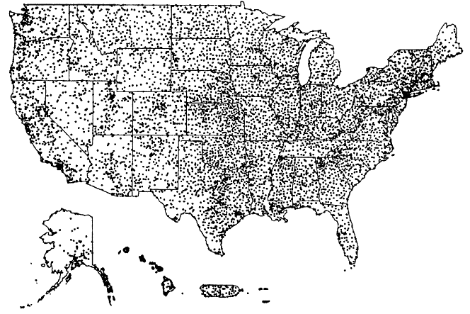
As Figure 1-1 shows, A and B stations today make up a network of 11,742 stations. The Coop Network also includes a small number of C stations, which serve a variety of special purposes, such as research on, and forecasts of, frost in fruit growing areas and measurements of precipitation in remote areas. The total number of cooperative observer stations managed and maintained by the NWS in 1997 was 11,866. The locations of these stations are shown in Figure 1-2.
Observing Equipment
With a few important exceptions, the instruments used by cooperative observers have not changed significantly over the past century. Snowfall and snow depth are measured manually with rulers or stakes. Liquid precipitation is measured with two types of rain gauges:
|
BOX 1-4 Coop Data: The Star Witness! Data from the Cooperative Observer Network can make or break a lawsuit. At times, the disposition of millions of dollars hangs on a few small data points, as in the examples below.
Source: Jensen, 1997. |
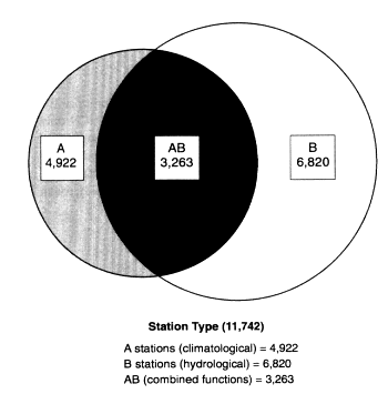
Figure 1-1
Types of Cooperative Observer Network stations.
Source: National Weather Service
- Nonrecording gauges are standard 8-inch rain gauges (basically cans) that require that the observer go outside, take a visual measurement (using a dipstick) of the water level in the magnifier tube, and record the information on a paper form. About 90 percent of the stations that report precipitation use nonrecording gauges.
- Recording gauges can be one of two types, the Belfort Fischer-Porter type or the Belfort Universal type. Recording gauges automatically weigh and record precipitation, using either a paper punch tape or paper analog chart. The paper record must be changed manually and mailed to the National Climatic Data Center (NCDC) for processing. The Belfort Fischer-Porter gauges represent 1960s technology.
Two basic types of instruments are used to measure temperature:
- Liquid-in-glass maximum/minimum thermometers require that the observer go outside to the radiation shelter (known as the cotton region instrument shelter) that houses the thermometers, manually read the thermometer, record the observation on the appropriate paper form, and reset the thermometer. This type of thermometer is used at about 40 percent of the nearly 5,000 A stations.
- Maximum-minimum temperature systems (MMTSs) consist of electric thermistors in pole-mounted plastic radiation shelters and remote display units inside the observer's house. MMTSs are powered by observer-provided electricity. Observations are recorded manually on paper.
Many observers at hydrological stations (B and A/B stations) phone in their observations shortly after taking daily readings. Transmissions of daily observations are mainly by voice, but at more than 2,000 hydrologic stations (the number is growing rapidly) observations are transmitted by coded message entered on a keypad. In the contiguous 48 states, data are transmitted using the Remote Observation System Automation (ROSA) or the Automated Tone Dial Telephone Data Collection System (ATDTDCS). These systems use touch pads or touch-tone telephone systems on which the observer enters observations manually using a prescribed code. Neither system was designed to provide high-quality climate data.
Observers at climatological stations (A, AB, and ABC) make and record observations of significant weather events, such as fog, hail, wind damage, blowing snow, and thunder, which are recorded manually on official forms but are not included in daily transmissions.
Operational Context
Many organizations other than the NWS and NCDC use cooperative data for research, climate analyses, and other purposes and disseminate it to end-users. The Coop Network operates in the context of many other public and private networks that collect weather data for various purposes. It also operates in the context of a far-reaching modernization program that is under way throughout the NWS. The modernization program includes the installation of automated observing systems and changes in staffing at weather offices.
Other Distributors of Coop Network Data
During the 1980s, state agencies and universities formed six regional climate centers (RCCs) to improve climate services at the local, state, and regional levels. The RCCs are stand-alone entities that receive base funding from the National Oceanic and Atmospheric Administration (NOAA), with supplemental funding from the U.S. Department of Agriculture (USDA), states, universities, and industry. The RCCs provide climate data and information, including Coop Network data, in their regions, with an emphasis on near-real-time data made available through interactive computer systems. Both current and historical data sets are stored in RCC computer systems that allow users to compare recent and historical data. This information is in great demand. In 1996, for example, the computerized data were accessed 109,000 times. In 1998, one of the RCCs reported a contact rate of 500,000 per month on the Internet.
Another important group of distributors of Coop Network data are state climatologists, who were funded by NOAA in all 50 states until 1973. The 45 remaining state climatologists,
|
State |
Number of Stations |
Standard Rain Gauge |
Cotton Region Shelter |
Maximum Minimum (therm.) |
Maximum Minimum Temp. System |
Fischer and Porter (recording rain guage) |
Universal (recording rain gauge) |
Tipping Bucket |
River Stage |
|
Alabama |
164 |
137 |
1 |
24 |
60 |
33 |
3 |
15 |
45 |
|
Arizona |
197 |
172 |
79 |
77 |
95 |
28 |
6 |
22 |
2 |
|
Arkansas |
203 |
162 |
1 |
19 |
71 |
55 |
6 |
16 |
61 |
|
California |
584 |
399 |
185 |
180 |
134 |
191 |
21 |
58 |
40 |
|
Colorado |
302 |
230 |
56 |
77 |
117 |
116 |
9 |
5 |
46 |
|
Connecticut |
47 |
40 |
9 |
16 |
9 |
12 |
6 |
2 |
13 |
|
Delaware |
10 |
9 |
0 |
6 |
2 |
2 |
1 |
0 |
1 |
|
Florida |
140 |
114 |
3 |
39 |
61 |
32 |
13 |
2 |
7 |
|
Georgia |
182 |
137 |
1 |
39 |
63 |
51 |
5 |
4 |
27 |
|
Idaho |
163 |
136 |
77 |
77 |
60 |
46 |
3 |
1 |
19 |
|
Illinois |
318 |
245 |
70 |
73 |
86 |
65 |
11 |
28 |
102 |
|
Indiana |
274 |
189 |
17 |
36 |
81 |
62 |
6 |
1 |
71 |
|
Iowa |
349 |
192 |
2 |
8 |
118 |
62 |
4 |
96 |
254 |
|
Kansas |
470 |
348 |
9 |
32 |
134 |
59 |
6 |
53 |
207 |
|
Kentucky |
213 |
199 |
1 |
65 |
36 |
43 |
10 |
6 |
50 |
|
Louisiana |
224 |
183 |
3 |
27 |
59 |
29 |
4 |
13 |
75 |
|
Maine |
113 |
83 |
5 |
21 |
37 |
20 |
8 |
0 |
14 |
|
Md. & D.C. |
86 |
63 |
3 |
47 |
11 |
13 |
4 |
4 |
17 |
|
Massachusetts |
80 |
69 |
16 |
28 |
17 |
10 |
10 |
3 |
15 |
|
Michigan |
289 |
225 |
5 |
130 |
50 |
44 |
13 |
3 |
89 |
|
Minnesota |
255 |
189 |
3 |
64 |
109 |
56 |
15 |
2 |
66 |
|
Mississippi |
199 |
160 |
0 |
42 |
69 |
64 |
10 |
14 |
59 |
|
Missouri |
303 |
240 |
11 |
43 |
124 |
74 |
9 |
26 |
124 |
|
Montana |
331 |
248 |
136 |
136 |
90 |
82 |
8 |
2 |
48 |
|
Nebraska |
389 |
260 |
18 |
26 |
141 |
54 |
4 |
5 |
136 |
|
Nevada |
118 |
106 |
49 |
45 |
66 |
29 |
1 |
5 |
9 |
|
New Hampshire |
71 |
62 |
1 |
19 |
21 |
20 |
3 |
0 |
8 |
|
New Jersey |
90 |
88 |
10 |
35 |
18 |
18 |
9 |
2 |
45 |
|
New Mexico |
197 |
186 |
50 |
85 |
94 |
69 |
6 |
5 |
4 |
|
New York |
300 |
240 |
26 |
57 |
90 |
72 |
0 |
4 |
84 |
Figure 1-2
Coop observer site location map and list of stations and equipment, by state.
Source: National Climatic Data Center and National Weather Service
|
State |
Number of Stations |
Standard Rain Gauge |
Cotton Region Shelter |
Maximum Minimum (therm.) |
Maximum Minimum Temp. System |
Fischer and Porter (recording rain guage) |
Universal (recording rain gauge) |
Tipping Bucket |
River Stage |
|
North Carolina |
235 |
218 |
6 |
84 |
89 |
39 |
15 |
5 |
39 |
|
North Dakota |
229 |
171 |
1 |
61 |
79 |
43 |
3 |
1 |
67 |
|
Ohio |
217 |
182 |
4 |
32 |
80 |
79 |
18 |
1 |
44 |
|
Oklahoma |
270 |
208 |
1 |
22 |
92 |
62 |
2 |
21 |
51 |
|
Oregon |
327 |
215 |
127 |
123 |
54 |
99 |
9 |
3 |
75 |
|
Pennsylvania |
323 |
226 |
47 |
71 |
63 |
123 |
18 |
6 |
106 |
|
Rhode Island |
6 |
5 |
1 |
2 |
1 |
1 |
1 |
0 |
1 |
|
South Carolina |
126 |
155 |
7 |
52 |
57 |
33 |
5 |
5 |
31 |
|
South Dakota |
218 |
172 |
3 |
31 |
135 |
35 |
3 |
2 |
56 |
|
Tennessee |
123 |
103 |
4 |
16 |
75 |
31 |
6 |
2 |
15 |
|
Texas |
832 |
713 |
46 |
104 |
311 |
154 |
43 |
43 |
115 |
|
Utah |
221 |
164 |
113 |
109 |
61 |
66 |
7 |
6 |
13 |
|
Vermont |
69 |
56 |
1 |
26 |
15 |
16 |
3 |
0 |
3 |
|
Virginia |
209 |
168 |
19 |
71 |
60 |
52 |
6 |
2 |
46 |
|
Washington |
225 |
149 |
53 |
48 |
88 |
67 |
9 |
17 |
41 |
|
West Virginia |
163 |
132 |
10 |
41 |
70 |
42 |
5 |
10 |
46 |
|
Wisconsin |
215 |
193 |
12 |
75 |
110 |
51 |
3 |
1 |
34 |
|
Wyoming |
229 |
157 |
10 |
85 |
96 |
65 |
6 |
10 |
42 |
|
Alaska |
254 |
168 |
112 |
109 |
66 |
24 |
12 |
10 |
74 |
|
Hawaii |
320 |
215 |
21 |
22 |
39 |
72 |
0 |
75 |
0 |
|
Puerto Rico |
98 |
90 |
1 |
15 |
22 |
22 |
2 |
0 |
0 |
|
Virgin Islands |
19 |
17 |
0 |
4 |
2 |
2 |
0 |
1 |
0 |
|
Hawaiian Islands |
3 |
1 |
1 |
1 |
1 |
0 |
0 |
1 |
0 |
only a few of whom are full-time, are now supported by various combinations of state and university funds. State climatologists are involved largely in archiving and analyzing climatological data pertaining to their states and in providing this information to the public, the media, researchers, and state agencies.
Other Surface Weather Observing Networks
The Coop Network is not the only weather observing network in the United States—although it is the oldest and largest. The Coop Network must be seen in the context of several other national observing networks that also serve vital national purposes.
- The NWS and Federal Aviation Administration (FAA) have established a network of about 1,000 Automated Surface Observing System (ASOS) stations that provide 24-hour coverage and report weather data hourly or more frequently (collected in real-time).
- The U.S. Department of the Interior has a network of about 700 stations that report precipitation and other data, frequently in real-time.
- The U.S. Army Corps of Engineers has 882 sites.
- The USDA has snowfall sensors and climate, forestry, and agricultural weather observing networks.
In several cases, the operators of these networks use data from some Coop Network sites to augment their own data. For example, the U.S. Army Corps of Engineers uses (and pays for the operation of) some 1,100 Coop Network stations. The other networks use coop data for a variety of purposes to support their operational missions. Thus, the Coop Network serves many national needs.
Within the NWS, the Coop Network is one of several networks for observing surface weather. ASOS, the joint program of the NWS and the FAA, has equipment at more than 800 airports and about 200 other locations and provides 24-hour coverage. ASOS data include air pressure; temperature; humidity; wind speed and direction; visibility; cloud heights and cloud amounts up to 12,000 feet; and type, intensity, and accumulation of precipitation (other than snow). ASOS precipitation gauges use tipping-bucket technology that provides precipitation measurements that are not compatible with (thus cannot replace) precipitation measurements from the Coop Network. NCDC does not publish data from unattended ASOS locations (mostly airports) in publications of climatological data because of the unreliability of ASOS measurements of liquid precipitation and the absence of measurements of snow or snow depth. NOAA, the NWS's parent agency, operates a network of marine weather data collection platforms, including ships and buoys, through the National Data Buoy Center and the National Ocean Service. Together, these networks provide observations of weather elements from the synoptic scale (ASOS) to the localized scale (the Coop Network). Among the NOAA observing networks, the Coop Network is the least sophisticated technologically, the least automated, and by far the least expensive.
Numerous state, regional, and even private networks (generally called "mesonets") serve more localized and/or specific needs for weather data. Mesonets and regional networks are discussed more fully in Chapter 2.
Coop Network and the NWS Modernization
The NWS began a sweeping national modernization program in the late 1980s with the phased introduction of several new observing systems (NEXRAD, ASOS, and GOES-NEXT) and AWIPS.1 In addition to installing new technologies, NWS has also made changes in staffing and has restructured forecast offices. Opportunities for real-time and retrospective uses of data from the Coop Network in NWS forecasts and warnings have been greatly expanded and will continue to be expanded as the acquisition of local data increases and locally run mesoscale numerical models are developed.
In 1993, NWS proposed a plan for modernizing the Coop Network by automating certain observations and data communications. Even though the NWS was not able to obtain funding to implement this plan, some changes have been made in recent years. As high-quality liquid-in-glass thermometers have become more expensive and difficult to obtain, an electronic system for measuring temperature (the MMTS) has been introduced in a portion of the network. As the demand for real-time data has increased, methods of communicating daily observations electronically (i.e., ROSA and ATDTDCS) have been selectively introduced in parts of the country. Most recently, a computerized data entry and communication system (PC ROSA) has been introduced to selected observers who supply their own computers and modems.
NWS's highest priority is providing forecasts and warnings for the protection of life and property. Although the overall system of cooperative observations has remained relatively unchanged, NWS modernization-driven changes to Coop Program staffing and responsibilities have resulted in significant changes in the way the Coop Program is managed at the field level. Some of these changes have adversely affected the ability of the Coop Network to contribute to NOAA's weather and climate services. The elimination of the NWS Agricultural Weather Program also increased the management oversight responsibilities of the Coop Network at some WSFOs. Chapter 2 examines a number of technical, operations, and management issues that have affected the Coop Network and the Coop Program in the context of NWS modernization.


