
-
Pleasure boaters and owners of small commercial vehicles rely on GPS for navigation.
-
Civilian pilots use GPS for navigation, crop-dusting, aerial photography, and surveying.
-
Airlines have saved millions of dollars by using GPS to hone their flight plans; GPS can be used for instrument landing at small, as well as large, airports and is making new air-avoidance systems possible.
-
GPS is used regularly for mapping, measuring the earth, and surveying. GPS has been used to map roads, to track forest fires, and to guide the blades of bulldozers in construction processes, making grading accurate to within a few inches.
-
Earth scientists use GPS to monitor earthquakes and the shifting of the earth's tectonic plates.
-
Telecommunications companies increasingly rely on GPS to synchronize their land-based digital networks, comparing their reference clocks directly with GPS time.
-
Satellite builders use GPS receivers to track the positions of their satellites.
-
GPS is being installed in automobiles so that drivers not only can find out where they are but also can be given directions. In Japan, 500,000 automobiles have already been equipped with a GPS-based navigation system.
THE GLOBAL POSITIONING SYSTEM: HOW IT WORKS
That's just the beginning. The current worldwide market for GPS receivers and technology is estimated at over $2 billion and is expected to grow to over $30 billion in the next 10 years.
It Started with Basic Research . . .
The history of GPS is an account of how basic research, in particular the creation of atomic clocks to study relativity, and Einstein' s physics, led first to a vital defense technology and then to a variety of important commercial applications. It is the story of how the quest for understanding the nature of the atomic world led to the creation of highly accurate clocks and how those were later put to use, in combination with satellite navigation technology, to satisfy the basic human desire to know where we are and where we are going.
For centuries, the only way to navigate was to look at the position of the sun and stars and use dead reckoning. Even after modern clocks were developed, making it possible to find one's longitude, the most accurate instruments could yield a position that was accurate only to within a few miles. However, when the Soviet Union launched Sputnik on October 4, 1957, it was immediately recognized that this “artificial star” could be used as a navigational tool. The very next evening, researchers at the Lincoln Laboratory of the Massachusetts Institute of Technology (MIT) were able to determine the satellite's orbit precisely by observing how the apparent frequency of its radio signal increased as it approached and decreased as it departed—an effect known as the Doppler shift. The
proof that a satellite's orbit could be precisely determined from the ground was the first step in establishing that positions on the ground could be determined by homing in on the signals broadcast by satellites.
The history of GPS is a story of how basic research, in particular the creation of atomic clocks to study relativity and Einstein's physics, led first to a vital defense technology and then to a variety of important commercial applications.
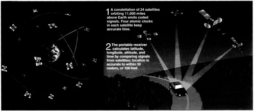
In the years that followed, the U.S. Navy experimented with a series of satellite navigation systems, beginning with the Transit system in 1965, which was developed to meet the navigational needs of submarines carrying Polaris nuclear missiles. These submarines needed to remain hidden and submerged for months at a time, but gyroscope-based navigation, known as inertial navigation, could not sustain its accuracy over such long periods. The Transit system comprised a half-dozen satellites that would circle the earth continuously in polar orbits. By analyzing the radio signals transmitted by the satellites—in essence, measuring the Doppler shifts of the signals—a submarine could accurately determine its location in 10 or 15 minutes. In 1973, the Department of Defense was looking for a foolproof method of satellite navigation. A brain-storming session at the Pentagon over the Labor Day weekend produced the concept of GPS on the basis of the department's experience with all its satellite predecessors. The essential components of GPS are the 24 Navstar satellites built by Rockwell International, each the size of a large automobile and weighing some 1,900 pounds. Each satellite orbits the earth every 12 hours in a formation that ensures that every point on the planet will always be in radio contact with at least four satellites. The first operational GPS satellite was launched in 1978, and the system reached full 24-satellite capability in 1993.
Considering how extraordinarily sophisticated the technology is, the operating principle of GPS is remarkably simple. Each satellite continuously broadcasts a digital radio signal that includes both its own position and the time, exact to a billionth of a second. A GPS receiver takes this information—from four satellites—and uses it to calculate its position on the planet to within a few hundred feet. The receiver compares its own time with the time sent by a satellite and uses the difference between the two times to calculate its distance from the satellite. (Light travels at 186,000 miles per second: if the satellite time happened to be, for example, one-thousandth of a second behind the GPS receiver's time, then the
The Development of GPS: A Chronology of Selected Events
This timeline of selected events emphasizes early research in physics that led to the development of the Global Positioning System. It does not provide a complete portrait of its development.
1938-1940
I.I. Rabi invents molecular-beam magnetic resonance at Columbia University in 1938. He and his colleagues apply magnetic resonance to fundamental studies of atoms and molecules. Possibility of atomic clock to measure gravitational red shift is discussed. Rabi is awarded the Nobel Prize for this work in 1944.
1949
Norman Ramsey invents separated-oscillatory-field resonance method at Harvard University, for which he was awarded the Nobel Prize in 1989. Jerrold Zacharias proposes using Ramsey's method to create cesium-beam “fountain” clock that would be accurate enough to measure gravitational red shift.
1949
National Bureau of Standards operates atomic clock based on microwave absorption in ammonia gas. Work starts on cesium-beam atomic clock.
1954
Charles Townes at Columbia University demonstrates operation of the first maser based on emission of radiation from ammonia molecules. Townes shared the 1964 Nobel Prize in physics.
1954-1956
Zacharias and National Company develop the first self-contained portable atomic clock, the Atomichron.
1959
Albert Kastler and Jean Brossel, working in Paris and at MIT, develop methods of optical pumping. Kastler is awarded the Nobel Prize for this work.
1957
Sputnik is launched in October by the Soviet Union. Satellite Doppler tracking is inaugurated at MIT Lincoln Laboratory and Johns Hopkins Applied Physics Laboratory (APL). Navy Transit program is started at APL in December.


