
1
National Importance of Coastal Engineering
Background and History
Coastal engineering is defined here as the application of skills, knowledge, expertise, and theory associated with purposeful engineering intervention in the coastal system. This definition includes the application of scientific principles underlying a broad range of traditional engineering disciplines to a zone in which there are significant interactions between water and land, including shorelines, bays, lakes, estuaries, inlets, river mouths, and harbors, and the structures within these environments. Coastal engineering involves the practice of civil engineering, as well as the sciences of oceanography and coastal geology, to control erosion; place, construct, and monitor coastal structures; nourish beaches; and develop and maintain ports, harbors, and related navigation facilities. More and more, the role of the coastal engineer is also expanding to encompass environmental and ecological issues, as the role of wetlands and water quality becomes more important. There are also opportunities for environmental remediation in areas where former coastal engineering practices have caused adverse impacts. Coastal sciences, defined here as nearshore oceanography and coastal geology, are the scientific knowledge base for coastal engineering. A number of coastal engineers are involved in research in many aspects of coastal sciences, such as sediment transport in the surf zone and the mechanics of breaking waves.
The discipline of coastal engineering in the United States began in the 1930s, largely as a result of research and other programs by the U.S. Army Corps of Engineers (USACE) and the U.S. Navy. The Sea Grant Program of the National Oceanic and Atmospheric Administration (NOAA) and the National Science
Foundation (NSF) have also supported the development of education in coastal engineering. Coastal engineering programs have been established at a small number of academic institutions, and the graduates of these programs have carried the technology to government agencies at the federal and state levels and to a small number of professional firms that design coastal works in the United States and around the world (Box 1-1).
Investments in these programs and facilities have remained level or even declined (in real dollars) for a number of years, even though national needs have increased. At the same time, other countries (notably Spain, the Netherlands, Japan, and Denmark) have made significant investments in coastal engineering research facilities and programs and have challenged or overtaken U.S. leadership in a number of areas. Spain and the Netherlands have developed advanced technologies for dredging and beach restoration. Japan has made significant technological advances in port infrastructure and technology. Consulting engineering firms in Denmark and the Netherlands have close ties to first-rate laboratories and advanced design software superior to those developed in the United States.
For U.S. ports to remain competitive in world trade, the United States must accommodate changes in shipping technology developed by Japan and Korea that require more modern and deeper draft facilities. Because many U.S. channels were originally designed to accommodate older, smaller, and shallower draft vessels, these challenges are formidable. The environmental constraints associated with dredging of U.S. ports and the disposal of the often-contaminated material are significant issues that must be resolved.
The following three examples—the effects of El Niño on the California coastline, erosion at St. Lucie Inlet, Florida, and the dredging problems facing the Port of New York and New Jersey—highlight some of the serious problems facing the nation's coastal areas.
El Niño and the California Shoreline
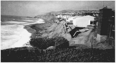
In late January and early February of 1998, the coast of California was hit by a series of powerful El Niño-influenced winter storms, causing 40 counties throughout the state, including most coastal counties, to be declared federal national disaster areas. The coastal damage included severely eroded beaches, flooded oceanfront homes, and the demolition of 10 bluff-top homes in the Pacifica area, just south of San Francisco, due to bluff failure that had undermined their foundations.
Sea-surface elevations recorded in San Francisco during the 1997–1998 El Niño event were higher on average than those observed during the last major El Niño event in 1982–1983 (Flick, 1998), with record numbers of major wave events (Seymour, 1998). Coastal damage, however, was less severe than during the previous El Niño event, which damaged 3,000 homes and 900 businesses along the California coast. The greater damage in 1982–1983 is believed to be
|
Box 1-1 History of Coastal Engineering In 1951, a founder of modern coastal engineering, M.P. O'Brien, wrote: Coastal engineering is primarily a branch of civil engineering that leans heavily on the sciences of oceanography, meteorology, fluid mechanics, and others. However, it is also true that the design of coastal works involve[s] many criteria that are foreign to other phases of civil engineering.... Along the coastlines of the world, numerous engineering works in various stages of disintegration testify to the futility and wastefulness of disregarding the tremendous destructive forces of the sea. Far worse ... has been the damage to adjacent shorelines caused by structures planned in ignorance of, and occasionally in disregard of, the shoreline processes ... The first practitioners of coastal engineering in the United States were motivated by problems created by fluctuations and migration of the shoreline and a curiosity about the dynamics of the natural system. The early practice of coastal engineering predominantly addressed erosion, as coastal structures were built without concern for their effects on shorelines. During the 1920s and 1930s, New Jersey was the choice oceanfront vacation location in the United States, and the erosion of some New Jersey beaches led to investigations first by the National Research Council Committee on Shoreline Studies and later by the U.S. Army Corps of Engineers through their Board on Sand Movement and Beach Erosion (BSMBE). The BSMBE was replaced by the Beach Erosion Board, created by Congress in 1930, which continues today as the Coastal Engineering Research Board. The second major impetus to the development of coastal engineering was a result of troop landings through the surf zone during the Second World War. Theories had been postulated since the mid-1800s to describe wave motion, and limited theory had been developed to predict wave transformation over idealized bathymetry. However, additional knowledge was needed to predict wave generation by wind, the transformation of waves over irregular bathymetry, and the onset of wave breaking and wave transformation through the surf zone. Investigations primarily by the Scripps Institution of Oceanography and the Council of Wave Research at the University of California at Berkeley established a better overall understanding of beach profiles, their response to storms, and sand movement in general. Research continued after the war, and the United States was recognized as the undisputed leader in the field of coastal engineering. The next major impetus for investigation was the exploitation of offshore petroleum resources in the Gulf of Mexico in the early 1950s. Movement into the Gulf began gradually with wells near the shoreline and then in deeper and deeper water. The vulnerability of platforms in an area subject to hurricanes and storm tides gave rise to a new round of research and development. The waves and wave forces could cause catastrophic platform failure, major economic losses, oil spills, and the possible loss of life. Recently, concerns about coastal hazards coupled with the rapidly increasing populations in coastal zones and the potential for widespread losses of life and property have stimulated research. Thus, to some extent, renewed concerns about beach erosion and stability are congruent with the early interests of coastal engineers and geologists. The interested reader is referred to Wiegel and Saville (1996) for further information about the early history of coastal engineering in the United States. |
Bluffs cut away by damage from El Niño storms in Santa Cruz, California, March 1998. Courtesy of Monty Hampton, U.S. Geological Survey, Menlo Park, California.
due to the repeated coincidental arrival of storm waves with high tides. Also, since then, a large number of seawalls and revetments have been built along the shoreline, providing some protection. An evaluation of historic coastal storm damage along the central coast of California indicates that in the last 85 years, 75 percent of the damaging storms have occurred in El Niño years (Storlazzi and Griggs, 1998).
St. Lucie Inlet, Florida
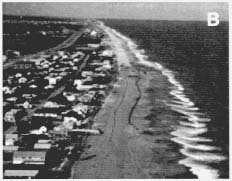
The shoreline south of St. Lucie Inlet, Florida, a man-made inlet on the east coast of Florida, has eroded landward hundreds of meters because of the interruption of the natural transport of sand along the coast. At the inlet, the amount of transport driven by the waves from north to south is on average 200,000 cubic yards (153,000 cubic meters) of sand per year. The original inlet was constructed in 1892, and a stabilizing jetty was added along its north side in 1928. Initially, no attempt was made to bypass the littoral drift from north to south, and Jupiter Island to the south soon became one of the most rapidly eroding areas in the state. By 1946, the northern end of Jupiter Island had eroded landward nearly one-half mile and was uninhabitable (see Figure 1-1). In 1983, a jetty was added on the south side of the inlet, and some bypassing of sand was begun, which slightly slowed the rate of erosion.
Jetties and breakwaters have had similar effects on downdrift erosion at a large number of other Atlantic, Gulf, Pacific, and Great Lakes coastal locations,
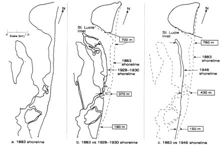
Figure 1-1
Progressive shoreline recession at St. Lucie Inlet, Florida. Source: Dean, 1991a.
with associated losses of coastal property. At a few inlets, sand bypassing has rectified most of the erosion caused by the presence of the inlet.
Port of New York and New Jersey
The Port of New York and New Jersey, the nation's largest petroleum port and third largest container port, is in serious jeopardy of losing cargo and experiencing associated economic hardships unless harbors and entrance channels can be deepened and terminals expanded. The Port Authority of New York and New Jersey is no longer able to dispose of dredged material at sea because much of the material in the harbors and the 240 miles of federally maintained navigation channels has been reclassified as contaminated. With the closure of its offshore disposal site, the port is facing immense costs for disposal (including the cost of shipping dredged material to disposal sites in other states). Four to five million cubic yards of contaminated sediments must be disposed of annually (USACE, 1996) and, at the present elevated costs of disposal, hundreds of millions of dollars will have to be spent annually to maintain the Port of New York and New Jersey—an amount nearly equal to the entire federal dredging budget. Many other U.S. ports face similar problems.
Challenges for the Future
The coastal engineer of the future will be faced with new challenges arising from the increasing concentration of population and investment in the coastal zone and the need to ensure that engineering projects are environmentally neutral or beneficial. The presence of diverse stakeholders in the coastal zone and the large risks associated with inappropriate designs and actions have created an urgent need for more authoritative information on which coastal engineers can base designs and on which decision makers can rely for developing long-range strategies for hazard reduction, sand management, port development, protection and restoration of habitat, and education of the public about the importance of managing coastal areas effectively.
Specific challenges to coastal engineers that will become more important in the future are listed below:
- Reduce the impacts and risks associated with coastal hazards, such as hurricanes, shoreline erosion, earthquakes, induced subsidence, and tsunamis.
- Restore the natural sand supply to the shoreline and restore the sand transport pathways along the coastal zone where it has been impacted by human activities.
- Provide sufficient and balanced information for making rational decisions about the shoreline.
- Modernize ports to maintain economic competitiveness and environmental quality.
- Ensure that future coastal engineering projects provide long-term solutions and maximize environmental enhancement.
Coastal and Shoreline Management
Rapid increases in investment along the shore have accompanied rises in income and quality of life. The population densities of coastal areas around the United States are now five times the national average. Currently, 50 percent of the population lives within 75 kilometers of a coast; this number is projected to increase to 60 percent by the year 2010 (Culliton et al., 1990; Williams et al., 1990). In California, the nation's most populous state, 80 percent of the 33 million Californians now live within 50 kilometers of the shoreline.
As the coastal population grows, so does the need for additional facilities for transportation, recreation, waste disposal, and other vital services. At present, approximately $3 trillion of infrastructure adjacent to the Atlantic and Gulf shorelines is vulnerable to coastal storms (IIPLR, 1995). When the West Coast is included, the amount of vulnerable property is even greater because approximately 86 percent of the 1,750 kilometers of the western coastline is eroding
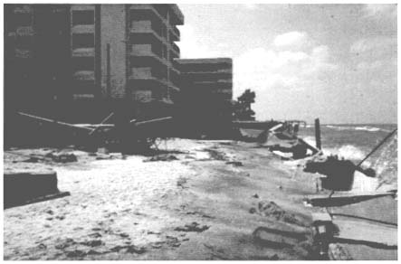
Seawalls destroyed by hurricane Elena in Pinellas County, Florida, September 1985. Courtesy of Robert G. Dean, University of Florida, Gainesville.
(USACE, 1971). The growing population in all coastal zones is also more vulnerable to coastal hazards, such as storms, tsunamis, and long-term coastal erosion.
Beaches are vital to our nation's economic and environmental well-being, both as places for recreation and tourism and as dynamic elements in coastal ecosystems. Because of the economic dependence of coastal communities on beaches and their role in protecting coastal properties and public infrastructures, beach erosion is a major concern for coastal communities and states. Tourism and coastal recreation are the fastest growing contributors to the economies of coastal states and to the overall national economy. Beaches and coastal parks are the primary destinations for foreign tourists to the United States. Ninety percent of their tourist dollars, an estimated $80 billion per year, is spent in coastal states (Houston, 1996).
Shoreline erosion along all U.S. coastlines, whether the erosion of cliffs and bluffs along the Pacific coast or the erosion of barrier islands and beaches along the Atlantic and Gulf coasts, is an ongoing natural process that has been exacerbated by human activities, such as the reduction of coastal sand supplies (e.g., by damming rivers) and the obstruction of littoral drift by coastal structures. The rise in sea level since the last Ice Age is a prime contributor to this erosion.
The continuing migration of people to the coastal states has increased their exposure to natural hazards and the total costs of damages from these hazards.
Table 1-1 Insured Losses from Hurricanes, 1989 to 1998
|
Hurricane |
Date |
Cost |
|
Hugo |
September 1989 |
$ 4.0 billion |
|
Andrew |
August 1992 |
$15.5 billion |
|
Aniki |
September 1992 |
$ 1.8 billion |
|
Opal |
October 1995 |
$ 2.0 billion |
|
Fran |
September 1996 |
$ 1.8 billion |
|
Georges |
September 1998 |
$ 2.1 billion |
|
Source: The New York Times, October 27, 1998 |
||
Insured losses from recent hurricane damage (hurricanes Hugo, Andrew, Opal, and Fran) and storm damage have exceeded $1 billion per year (see Table 1-1). Hurricanes Andrew and Hugo alone caused damage estimated at $40 billion (Ross, 1995). These costs are expected to increase as construction along the coasts continues unabated. Pielke and Landsea (1998) show that the 10 most damaging hurricanes from 1925 to 1995 would have accounted for more than $10 billion dollars in damage each if they had occurred after 1995 (due largely to the increase in coastal population). In fact, the most damaging storm would have caused more than $70 billion in damages.
A number of coastal engineering problems that are likely to become more serious in the future are discussed below: coastal hazards, beach and inlet management, and changes in shorelines. Following these are discussions of coastal monitoring and public education, which would improve our ability to address these problems.
Coastal Hazards
As coastal populations expand, losses from coastal hazards will continue to increase. These hazards include hurricanes, northeasters, and the rising sea level; earthquakes, bluff erosion, and El Niño-related storm damage on the West Coast; tsunamis in Hawaii, Alaska, and the Pacific coastal states; and the loss of sand supply along many coastlines because of human intervention.
Eighty-six percent of the coastline of California is eroding (USACE, 1971), and the last two El Niño-related storm seasons (1982–1983 and 1997–1998) caused more than $150 million in damage. The 1989 Loma Prieta earthquake was responsible for coastal bluff failure along 200 kilometers of shoreline (Griggs and Plant, 1998), and the Pacific Northwest coastal zone is threatened by a large subduction zone earthquake that could produce a tsunami. An NSF-sponsored report has noted that more people have died in the United States in the last 50 years from tsunamis than from earthquakes (NSF, 1984).
The options for coping with coastal hazards include living with the hazard, reducing the risks, or retreating. The best option will depend on the locale and costs. It is possible to mitigate or reduce the impact of certain coastal hazards (wave impact and inundation, for example); however, it is extremely expensive to eliminate the effects of gradually rising sea level and very large magnitude events such as hurricanes or tsunamis, although storm-surge barriers have been built in many countries, including the United States, and tsunami barriers have been constructed in Japan. Improvements in construction and better mitigation strategies may keep losses at manageable levels, but appropriate responses may vary with time and circumstances.
In their natural condition, shorelines respond dynamically to the forces of storms, as well as to climate-related effects, such as sea level changes or El Niño events. At a particular locality, such as a coastal bluff in California, this response may primarily be episodic bluff failure and shoreline retreat. Along the barrier islands of the Atlantic and Gulf coasts, responses may range from gradual erosion of the shoreline to a seaward and landward oscillation of the shoreline over time. These natural responses challenge coastal engineers first to understand the dynamics and then, if possible, to develop cost-effective ways to minimize the adverse effects of human intervention on these natural systems.
Armoring (i.e., the construction of seawalls or revetments) has been a common approach to stabilizing shorelines and one means of reducing risks from coastal hazards along all coastlines of the United States. As the percentage of armored shoreline has increased in response to both increasing oceanfront development and ongoing cliff and bluff retreat, questions have been raised about the effects of these structures (which are intended to protect property) on public beaches (Pilkey and Wright, 1988). The conflicts between the beneficial and adverse effects of coastal armoring have not been resolved and will certainly become more serious in the future.
The most common approach to maintaining the shoreline is beach nourishment—adding large quantities of beach quality sand to advance the shorelines seaward. Beach fill projects commonly cost millions of dollars and provide only short-term relief to the problem of erosion. Beach fill projects also provide some storm protection by replacing sand that has been washed away. Beach fills have only been studied and monitored to evaluate their effectiveness for a decade or two, and only a few have been monitored adequately. A better understanding of the interactions of beach fill with ongoing coastal processes will help engineers design future projects.
However, because coastal processes are complex and each site is unique, the best basis for predicting the effects of shore protection projects is documentation of previously constructed projects in similar areas. The documentation should span a number of years after project completion because large projects often have subtle effects that can take many years, even decades, to become apparent. In addition to the physical performance of a project, monitoring and documentation
must include bathymetric, environmental, and economic performance, including positive and negative effects beyond the project boundary. Monitoring should also include the effects of the project on the biota.
Management tools that would improve coastal engineering include the capability of predicting the efficacy of various strategies (including human intervention and taking no action) for the purpose of formulating long-term shoreline management plans. Management includes more considerations than the physical systems of beach nourishment and armoring; it also involves economic, social, and ecological considerations. Better management tools would enable planners to examine various scenarios and assess their effects. For example, tools could be developed for comparing alternative scenarios with rising sea levels caused by the greenhouse effect and global climate change. The optimal solution to a problem might be to adopt a course of action in the near term that can be adapted or changed when some of the uncertainties are narrowed. In the case of an eroding beach on a barrier island, for example, the near-term option might be beach nourishment. Several decades later, however, after the performance of several projects had been evaluated and the prospects of an accelerated rise in sea level had been clarified, the range of management alternatives could be reevaluated and a new strategy developed.
Prudent beach management is an attempt to maintain sandy beaches and littoral transport1 along the shoreline. Several options are available for managing beaches, but many of these involve not just the local beach of interest but also a wider geographic area. Historically, each project has been treated separately. Therefore, two projects located within the same littoral cell2 were often treated completely separately in terms of calculating benefits, assessing needs, developing designs, and planning for engineering and construction. The costs of planning, design, engineering, and construction are much higher for some projects than they would be with a regional systems approach. The Delaware Bay Main Channel Deepening Project, for example, and the Delaware Bay Shore Protection Project have been authorized, designed and engineered, and constructed as independent projects, although it would have been economically and logistically more efficient to combine them. The identification and formulation of long-term management strategies to guide local and state government policy makers in the preservation of beaches and to link independent projects within regional sand basins are essential to protecting our limited sand resources.
A. Fenwick Island, Delaware, in an eroded condition, with a short beach offering little storm protection or recreational function.
B. Fenwick Island receiving beach nourishment sand pumped from approximately three miles offshore.
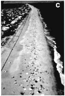
C. Fenwick Island after nourishment.
Courtesy of Anthony P. Pratt, State of Delaware, Department of Natural Resources and Environmental Control, Dover.
Beach and Inlet Management
Shoreline erosion is often caused by disruptions in natural sand transport at inlets resulting from jetties, channel dredging with offshore sand disposal, and losses to interior shoals. Improvements in sand bypassing at inlets will reduce beach erosion along the adjacent beaches and could reduce the need for beach nourishment in the future. As part of the recently adopted St. Lucie Inlet Management Plan, located in Martin County, Florida, more than one million cubic yards (765,000 cubic meters) of beach quality sand have been deposited on the downdrift beaches of Jupiter Island.
Long-term, chronic beach erosion is usually the result of the mismanagement of sand resources. An example of beach erosion caused by an inlet are the beaches downdrift of Lake Worth Inlet, Florida, where historic maintenance practices have caused the loss of more than 500,000 cubic yards (383,000 cubic meters) of sand per year in the past decade. Palm Beach Island has begun a large-scale effort to restore the highly eroded 15.5 miles (25 kilometers) of shoreline by armoring more than 60 percent of the island's shoreline. Many other examples of poor inlet sand management practices along beaches fronting the Atlantic, Gulf of Mexico, and Great Lakes shorelines could be cited.
Effective management of the nation's coastal sand resources would significantly reduce the costs of future beach management. Comprehensive studies would lead to a better understanding of the primary sand transport pathways at each inlet and the development of sand management strategies and plans to implement corrective actions. Sound sand management plans would give policy makers a much needed tool for formulating local, state, and national policies.
Tidal inlets and river entrances interrupt otherwise continuous shorelines and are often sites of human intervention, primarily for navigation, such as the deepening of channels and the construction of jetties. Stabilized channel entrances often create accumulations of sand at the updrift3 jetty and depositions of sand on interior inlet and flood shoals, as well as offshore as a result of natural ebb currents or required maintenance dredging. For many decades, sand dredged from tidal inlets was disposed of offshore, far outside of the natural littoral system. Dean (1988) has estimated that 80 to 85 percent of the shoreline erosion in Florida can be attributed to the effects of tidal inlets. The use of sand bypassing techniques to reestablish the natural sand transport at many inlets will reduce the high costs of long-term, chronic erosion of downdrift beaches and the degradation of biological resources, which often results from the deposition of sand in bays. Otherwise, long-term chronic erosion is likely to continue.
An example of good sand management is Indian River Inlet on the Delaware
coast. Before the sand management plan was put into effect, sand accumulated by the updrift jetty caused severe erosion of the downdrift beach, jeopardizing the major access and hurricane evacuation route for this section of the Delaware coastline. Since 1990, a mobile sand bypassing system has been regularly moving sand across the inlet, which has solved the critical erosion problem (Clausner et al., 1991). This solution was developed by coastal engineers with the USACE and coastal experts in the Delaware state government and at the University of Delaware.
Changes in Shorelines
With more than 75 percent of the nation's sandy shorelines eroding, proper management will require an understanding of coastal dynamics based, in part, on an analysis of historical changes documented through surveys, historical maps, and aerial photographs to determine rates of erosion. Erosion occurs on both developed and natural shorelines and should be the dominant factor in selecting long-term management options.
The documentation of shoreline changes for the barrier island shorelines of the Atlantic and Gulf coasts would be more accurate if it included sand budgets for large-scale littoral systems. Complete documentation would require a long-term database of shoreline positions. In general, historical data are sparse and do not reflect the full effects of human intervention, which can be positive or negative. Historical photographs do not generally capture episodic, seasonal, or storm-induced fluctuations. The development of long-range shoreline management strategies will require that high-resolution hydrographic (bathymetric) data be collected at frequent intervals. Fortunately, with the advent of the global positioning system (GPS) and other modern surveying systems, the nearshore zone can be surveyed rapidly with high spatial density at a relatively low cost.
The rise in sea level has been a topic of considerable debate for several decades, most recently in association with global warming. The long-term rate of 1.2 millimeters per year is apparently increasing and has already had significant effects on the barrier island shorelines of the Atlantic and Gulf coasts, as well as shorelines in the Mississippi Delta area, where, as a result of regional subsidence, the rates are about eight times the average. A number of studies on the effects of global climate change have predicted the worldwide average rates of sea level rise will be substantially greater than the current rate of 1.2 millimeters per year. By the year 2100, rates will range from 50 centimeters to 150 centimeters per century, which is 4 to 12 times the current rate. In an earlier report, the National Research Council's Marine Board (NRC, 1987a) called for more observations of relative rises in sea level and recommended that coastal project designs incorporate reasonable estimates of future rises.
The magnitude and impact of short-term local rises from storm surges or El Niño events are also very important. The 1982–1983 El Niño event elevated sea
levels 30 centimeters or more along the coasts of California and Oregon, and the 1997–1998 event produced even larger changes (Flick, 1998). Brief rises in sea levels associated with major hurricanes are even more significant. Hurricane Camille (1969) caused a 22.4 foot (6.8 meter) rise at Pass Christian, Mississippi; Hurricane Hugo (1989) raised the sea level by more than 20 feet (6 meters) in Bulls Bay, South Carolina (Garcia et al., 1990); and Hurricane Opal (1995) raised it by more than 15 feet (4.6 meters) at Panama City, Florida (Leadon, 1995). These surge levels lasted for several hours and caused considerable flooding and loss of property from water damage and wave attack.
Coastal Monitoring
USACE has monitored a number of coastal projects under the aegis of the Monitoring of Completed Coastal Projects Program (MCCPP), which was renamed the Monitoring of Completed Navigation Projects Program (MCNPP) to reflect the scope of the project. Unfortunately, only a few projects (federal or otherwise) have been documented adequately, and the lack of documentation has given rise to misinformation, prolonged debates and disagreements, and faulty designs for future projects. Moreover, some of the projects that have been documented have not been thoroughly analyzed. Some states now require that sponsors of coastal projects monitor the effects and coastal processes in considerable detail. Information from these projects will be invaluable to engineers and project managers developing designs and management strategies for future projects. Because most beach nourishment projects are publicly funded through tax-based revenues, the general public is entitled to better information on project performance. To date, few efforts have been made to publicize evaluations of project performance. Long-term continuous monitoring programs could provide data for a comprehensive database on constructed projects, which could be made available to designers of future projects (NRC, 1995).
Human activities on beaches, marine parks, estuarine and bay waters, and other coastal resources often cause a decline in their overall environmental quality, the very quality of these resources that sustains tourism and recreation. Coastal resources, which are limited to begin with, are coming under increasing pressure by developers and tourists. Recreational use and nature-based tourism should be part of an overall environmental management program that includes protection of the shoreline, monitoring, and educational programs.
Ports and Waterways
Port Operations
Ninety percent of the nation's international trade, more than two billion metric tons per year, flows through U.S. ports and harbors. In recent economic
projections, the amount of import cargo will triple by 2020, provided the United States can provide the facilities the shipping industry needs (AAPA, 1998). Nationally, ports and port users generate nearly 13.1 million jobs, contribute approximately $743 billion to the gross domestic product, and provide nearly $200 billion in tax revenues at all levels of government (MARAD, 1997). For states located on major bodies of water (the Atlantic, Pacific, and Gulf coasts and the Great Lakes) and waterways (major rivers and large lakes), ports and harbors play a major role in the regional and local economy.
The trend in the shipping industry is toward larger vessels that can carry more cargo with smaller crews. The primary goal is to load, move, and unload waterborne cargo efficiently. This means ships spend a minimum of time at the berth handling cargo, frequently 36 hours or less, and a maximum of time at sea. World shipping operations that carry international cargo prefer one-stop loading and unloading of their cargo at the user's doorstep. This requires large, efficient vessels and modern shoreside facilities. Water transport is the cheapest means of moving large volumes of cargo, and shipping companies have the option of trying new ports-of-call that provide the most efficient facilities for handling cargo. U.S. ports that cannot meet these shipping requirements are already losing cargo to ports outside the United States (MARAD, 1997).
A major factor that contributed to the success of U.S. ports in the past was continued maintenance dredging and new construction dredging for expansion. The former involved removing approximately 285 million cubic yards (218 million cubic meters) per year of sediment from navigable waterways (USACE, 1997). Continued dredging is essential for U.S. ports to compete internationally. Without it, they cannot accommodate the new large ships that require deeper and wider channels. Ports that cannot provide adequate water depth, safe maneuvering and loading and unloading areas, and modern terminal facilities with efficient land transportation connections will cost shipping companies more for cargo delivery and will eventually lose business to more modern ports.
Most Gulf and East Coast ports and a few West Coast ports have size restrictions. A recent survey showed that U.S. ports that handle international cargo plan to increase their water depths to 40 to 50 feet (12 to 15 meters) at low water. Ports that want to ensure their capability as international ports of call (i.e., that can handle large around-the-world container ships) plan to dredge to 50 to 55 feet (15 to 17 meters) and, if necessary, widen their channels (AAPA, 1998).
Presently, the cost of federal and local maintenance and new construction dredging is $632 million annually (USACE, 1997). This amount does not include funds spent by local port authorities for maintenance or new construction dredging.
The fast and efficient operation of ports that can accommodate large ships will require real-time monitoring and modeling systems of currents, waves, and water levels; well maintained channels and navigation aids; safe, protected berthing sites; efficient methods for loading, unloading, storing, and moving
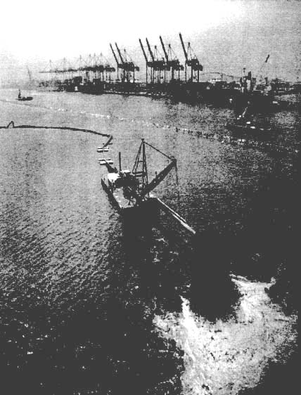
Dredging operations in the Port of Los Angeles. Courtesy of the Port of Los Angeles.
cargo; and well designed interfaces to land-side transportation. The use of large ships reduces the shipping industry's transportation costs and thus the overall cost of goods. These vessels must be able to enter through safe harbor entrances, transit through adequate channels, and maneuver in turning basins that do not
constrict their movement (horizontally or vertically), and arrive at a stable berth for quick unloading and loading of cargo.
Environmental Concerns and the Disposal of Dredged Materials
Federal, state, and local laws have established environmental standards for port waters and the protection of marine habitats. The removal and, more important, the disposal of dredged materials cannot degrade the placement area or the larger marine environment. The environmental sensitivity of each location is unique depending on the chemical and physical properties of the dredge spoils and how and where the dredged material is placed.
With the growing demand for deeper ports and increasingly stringent regulations of contaminated spoils, the cost of dredging to ports and the federal government has increased dramatically. Historically, most dredged material has been placed in open coastal waters, but there is a growing trend toward the use of confined upland and in-water containment areas, when the materials and methods are environmentally compatible. These and other locations present new challenges and associated costs. A recent study comparing dredging, material transport, and placement costs indicates that the unit costs in the United States are 3 to 20 times higher than the average world unit costs due, in part, to concerns about environmental quality (PIANC, 1998).
Environmentally sound methods of disposal are urgently needed. One option under consideration for ports is the use of artificial islands for the containment of contaminated sediment. These islands, which would be among the largest civil engineering structures in the world, would be constructed of caissons or rubble-mound seawalls and would have to withstand severe conditions and have a very long design life. Another option is capping contaminated sediments in pits in the harbor or at offshore disposal sites, which involves placing contaminated material on the ocean floor and covering it with a layer of clean clay and sand as a cap to prevent the material from moving.
Because new port construction and maintenance usually occur in environmentally sensitive areas, ports often compensate for damage caused by dredging or other work by improving the environmental quality of other degraded areas in the region (e.g., establishing or improving coastal wetlands, providing new material for beach nourishment, or enhancing aquatic habitats).
Environmental Quality
Coastal engineers now play an important role in coastal environmental management, and this involvement is expected to increase in the future (NRC, 1994). They are generally involved in the areas of dredging and managing dredged material, beach nourishment, addressing water quality issues, and wetlands restoration.
The loss of coastal marshlands and degraded water quality in estuaries and bays has resulted in a significant decline in environmental quality (NRC, 1990). Coastal marshes are important for marine and upland biotic communities, and the effects of degraded water quality and loss of habitat on marine systems have created major problems. When some species flourish while others die off, the result is an unbalanced ecosystem and a significant loss of diversity. Marine nurseries and protected habitats are necessary to sustain the marine fisheries industry, as well as to meet the growing demand for recreational fishing and nature-based ecotourism.
The development of hydrodynamic and water quality models will require an understanding of tidal and freshwater discharges, nutrient loadings, point and nonpoint discharges, and pollutant loadings to the system. Storm water runoff and water quality degradation continually stress marine and terrestrial ecosystems. Degraded water quality in rivers, estuaries, and bays presents challenges to coastal engineers to design inlets and channels that can improve flushing of degraded water. Innovative design strategies will be necessary for site-specific solutions, as well as monitoring to ensure that these solutions restore water quality in estuaries and wetlands and biodiversity to marine ecosystems.
Environmental Preservation
Early coastal engineering projects were conducted without regard to their adverse environmental impacts. In light of new concerns about the environmental quality and integrity of coastal zones, projects in the past 20 years have been required to show minimal adverse impacts and, wherever possible, positive environmental impacts (NRC, 1994). Examples of environmentally sensitive projects include the creation of wetlands and the use of dredged material for beach nourishment that provides habitats for endangered species, including nesting habitats for sea turtles and piping plovers. Remediation is often necessary to reverse the adverse impacts of former practices.
The environmental concerns and mitigation requirements of the past few decades have led to widespread, sophisticated restorations of coastal wetlands, such as salt marshes and mangroves that line estuaries, barrier islands, and other shoreline environments. Restoration projects require an understanding of inter-tidal conditions, including tidal channels. In many ways, the nonbiotic design of wetland restoration projects is similar to the design of beach restoration projects. The most successful restorations and enhancements are designed by teams of coastal engineers and environmental scientists.
Public Education
Ecosystem protection and biological resource management are often seen as competing with coastal engineering projects. A major public education program
would show how successful coastal engineering projects could be environmentally sensitive and mindful of ecosystem health. Urban and regional planners and public administrators in coastal areas would also benefit from courses in coastal processes and dynamics and inlet and beach management.
National Defense4
During the Cold War period, much oceanographic research and development was related to deep water. As the plans for national defense are being adjusted to accommodate post-Cold War conditions, operational oceanography is also changing. The Navy is now focusing on coastal regions, and better characterizations of the littoral zone are of major importance to national defense. The Navy's concerns are focused on the challenges of understanding and predicting natural coastal environments that change more rapidly in time and space than deep-ocean environments.
The Navy needs local environmental information on relatively small spatial scales, short time scales, with coast-related parameters (e.g., surf conditions, water clarity, atmospheric visibility, wind and current vectors, the nature of the coastline, the variability and stability of the seabed, high-resolution bathymetric data, and concentrations of local marine life). Hybrid platforms with different types of sensors for local and regional observations will have to be developed and deployed to address these parameters. The capability of measuring, understanding, and predicting variations in these parameters will require the development of new research and engineering techniques, as well as new modeling concepts and programs.
Coastal engineering is a significant part of defense-related planning, operations, and the development of innovative technologies. In many ways, the research, development, and educational needs of the Army overlap those of the Navy and the Marines. In some areas, however, the Army has unique needs based largely on providing sustained logistical support over long periods of time, which could involve moving and storing large amounts of materiel (this unique issue is referred to as logistics-over-the-shore [LOTS]).
Planning
The Army considers the selection of potential LOTS sites to be extremely important. The site must have natural environmental characteristics (e.g., waves,
water levels, currents, and beach and bar movements) that allow sustained, rarely interrupted throughput. At the present time, open-coast LOTS operations are highly sensitive to wave conditions. Selected beaches must have topographical and other characteristics that allow for easy movement. For operations that involve existing harbors, the important questions are the maintenance or improvement of navigation to support large ships and the rapid repair or enhancement of port facilities.
Operations
Once a LOTS site has been selected and operations begin, coastal engineers must be able to forecast critical events that could disrupt operations or destroy critical facilities. Forecast technologies will be much the same as the technologies necessary for Marine or Navy SEAL operations on beaches (i.e., accurate forecasts of waves, water levels, currents, sediment transport, and beach morphology). The Army will also need information on the shoaling of navigation channels and short and long wave conditions in harbor areas. These forecasts will require sensor systems that can monitor natural environmental parameters.


