
Page 50
8—
Radiosonde Observations
Summary of Trends
Several data sets compiled from radiosonde observations have been used to monitor atmospheric temperature trends (Angell and Korshover, 1975; Angell, 1988; Parker et al., 1997). Recent analyses of various versions of these data sets indicate slight warming trends of up to 0.1 °C/decade or more in lower tropospheric temperature for the period during which MSUs have been operational (1979–98). Exact trend values vary depending on the data source, treatment, and trend-fitting method (e.g., Angell, 1999; Parker et al., 1997; Santer et al., 1999; Santer et al., 2000).
Sources of Uncertainty in Trend Estimates
There are several unresolved challenges in determining reliable, global, radiosonde-based temperature trend estimates. These challenges are outlined below, together with some of the methodologies that have been used to address them.break
Page 51
Background
Radiosondes have for several decades been the primary means of obtaining atmospheric vertical profile data from the surface to the lower stratosphere. They are routinely used as input to the operational meteorological analyses that are used in numerical weather prediction and meteorological diagnostics. In the absence of other in situ measurements, radiosonde observations have recently been used to assess trends of atmospheric conditions above the surface, even though they were not designed for this purpose. The instrument packages carried aloft by balloons are generally equipped with temperature, humidity, and pressure sensors, whose measurements are radio-transmitted to a ground receiving station. Wind data are also obtained by tracking the position of the instrument during ascent. Temperature sensors vary according to the manufacturer and model of the radiosonde; most contemporary instruments carry a thermocapacitor, wire resistor, thermocouple, or bimetallic sensor. An excellent overview of radiosonde instruments, including discussion of measurement error characteristics, is provided by the World Meteorological Organization (WMO, 1996).
Currently, the global radiosonde network nominally includes about 900 upper-air stations, of which about two-thirds make observations twice daily (at 0000 and 1200 Coordinated Universal Time (UTC)). The network is predominantly land-based and favors the Northern Hemisphere (Figure 2.6). Radiosondes can achieve heights of about 35 km, although many soundings terminate below 20 km because less expensive balloons burst at a lower altitude. There has been some deterioration in the radiosonde network in recent years. The loss of navigational systems used to track the sondes has led to at least temporary closing of some stations, particularly in Africa. Efforts to reduce operating costs have led to station closures and reduced observing schedules in some parts of the former Soviet Union and elsewhere.
Measurements are made and transmitted with approximately 10–50 m resolution during ascent, but archived sounding data may contain only about 20 data levels per sounding. Radiosonde-based data sets for climate monitoring come from two basic data products: individual soundings containing all reported data (Angell, 1988), or monthly mean data (known as CLIMAT TEMP reports) at mandatory pressure levels only (Parker et al., 1997). Only about 45% of stations provide CLIMAT TEMP reports in addition to the daily sounding data. Missing daily datacontinue
Page 52
can cause substantial random errors in estimates of monthly means, especially if the available data are unevenly distributed in time.
Data Homogeneity Problems
Sampling Changes: The spatial and temporal characteristics of radiosonde observations have tended to change through time, in part because these observations are generally made for operational weather analysis purposes rather than long-term trend detection. Spatial biases may be introduced through changes in the number, location, and characteristics of radiosonde sites. Further exacerbating this problem is the fact that the land surface characteristics of radiosonde sites may change through time, biasing surface and boundary layer observations. Shifts in site locations of even a few kilometers can have a similar effect. In addition to spatial sampling issues, biases can also be introduced if the diurnal sampling time or frequency changes. For example, observing times were not fixed at 0000 and 1200 UTC until 1957, making data from earlier years potentially biased relative to more recent observations. Even today, measurements are not always conducted twice daily at all stations.
Instrument Changes: There have been many and widespread changes of radiosonde sensors during the history of the global radiosonde network. These changes often brought useful improvements in precision and accuracy, essential for weather analysis and forecasting, but they also prejudiced the homogeneity of the records from the perspective of climate change analysis (Gaffen, 1994). For example, efforts to update the sonde's temperature-sensing technology and efforts to mitigate the effects of solar radiation on the sondes have, in some cases, introduced time varying biases. Parker and Cox (1995) documented an increased dominance of radiosondes made by the Vaisala company in recent years. Since their paper was published, many North American stations have also switched to Vaisala instruments, although stations in Russia, China, and Japan continue to use national instrumentation. Within each class of radiosondes (such as Vaisala), there have also been progressive developments (e.g., the Vaisala RS11 through RS90 series), which have introduced heterogeneity. Another problem is that the documentation of instrument types and the timing of instrument changes is not always complete or accurate (Gaffen, 1993).break
Page 53
Data Treatment Changes: Changes in the way raw radiosonde observations are processed can also have a significant impact on the long-term record. Changes in corrections applied to the temperature data (to reduce errors resulting from solar and infrared radiation impinging on the sensor and errors resulting from the time lags in instrument response as the sensor ascends through the atmosphere) are detectable in the data (Gaffen, 1994). However, these effects are more noticeable in the data from the upper troposphere and lower stratosphere than from the lower troposphere, and more noticeable early in the radiosonde record than in recent years (the time of overlap with MSU observations). A third type of change in data treatment affects the CLIMAT TEMP monthly averages, but not the individual sounding data. Changes in the rules by which stations compute their monthly averages, including which observing time to use and how many days of data must be available, can have large effects, which are revealed by comparisons with monthly averages computed using a consistent set of rules (Gaffen et al., 2000).
Variety of Methods of Estimating Global Trends in Layer-Mean Temperatures
Methods for Obtaining Layer-Mean Temperatures: The MSU temperature product discussed in the previous chapter is a vertically-broad and non-uniform representation of tropospheric temperature. Therefore, comparisons with radiosonde data are most meaningful if the radiosonde data are processed to represent the same portion of the atmosphere as the MSU product. At least two different techniques have been used. The simplest involves computing the mean mid-tropospheric temperature, weighting all levels (e.g., 850 to 300 hPa) equally. The disadvantage of this method is that it does not reflect the unequal contributions from each of the levels that underlie the MSU product. In the second technique, radiosonde temperature data at different altitudes are weighted to more closely resemble what the satellite would have observed. However, this method, termed the 'static weighting method,' does not account for variations in atmospheric moisture as a function of space or time. The biases associated with this technique are, however, not large relative to other sources of bias in the global time series (Santer et al., 1999).break
Page 54
Methods for Calculating Global Average Temperature Anomalies: Estimates of global and regional temperature anomalies depend on the selection of stations, the method of averaging station anomalies, the method of gridding, and the method of averaging gridded values, which are discussed below.
For the reasons mentioned previously in the Sampling Changes section, fixed networks smaller than the full observing system have been chosen for the determination of temperature trends. Angell and Korshover (1975) selected 63 stations in their pioneering efforts to develop a global temperature monitoring capability. The Global Climate Observing System / Baseline Upper-Air Network designates approximately 150 stations for the same purpose. Other efforts (e.g., Oort and Liu, 1993, Parker et al., 1997) attempt to incorporate data from as many stations as possible with an aim of maximizing spatial and temporal coverage. That approach, however, suffers from the inconsistencies that are introduced into the network through time.
An annual temperature anomaly of the selected stations may be calculated as the average of the available months, or as an average of the available seasons. If the record is incomplete in a systematic manner, the weighting implicitly applied to individual monthly data may introduce biases. Similar considerations apply to the calculation of monthly statistics from daily data, and these are especially relevant when a month's data consist of a different number of daytime and night-time ascents.
To grid the station data, anomalies within a gridbox may either be weighted equally, or weighted according to the distance of the station from the center of the gridbox (e.g., Parker et al., 1997). Some schemes also fill unsampled gridboxes using eigenvector-based reconstructions (Parker et al., 1997), objective analysis schemes such as ''Conditional Relaxation" (Oort and Liu, 1993), or optimum interpolation (used on sea surface temperatures by Reynolds and Smith, 1994). The validity of interpolations decreases away from the observation sites in proportion to the spatial decorrelation scale of the temperature data. Finally, model-based reanalyses, which also incorporate surface and satellite observations, use complex data-assimilation schemes based upon known physical relationships (e.g., geostrophy) and detailed statistical quality controls (Kalnay et al., 1996; Uppala, 1997).
There are many ways of averaging gridded temperature anomaly values into global indicators. Although each of these has its strengths,continue
Page 55
the problem of incomplete spatial coverage remains nonetheless. The most direct method is to average all of the gridded anomalies, weighting each according to the area of the gridbox (Parker et al., 1997). This approach naturally places more weight on the Northern Hemisphere where there are more observations. Alternatively, the grid boxes may first be averaged into larger grid boxes before averaging globally (e.g., Parker et al., 1997). In data-sparse regions, this procedure gives greater weight to isolated boxes where data happen to exist, and was shown by Santer et al. (1999) to have a noticeable impact on trend estimates. Another method is to calculate latitudinal averages and then to average these bands (e.g., Angell, 1988). For the tropics, where data are sparse but also where temperature variations tend to be spatially coherent, this form of averaging offers some potential advantages (Wallis, 1998). On the other hand, it can introduce large errors if relatively few stations are operating within a given latitudinal band, and if their temperatures are not representative of the latitudinal average.
Efforts to Correct the Problems
It is only in the past few years that serious attempts have been made to adjust radiosonde data to remove the effects of artificial changes, and several different approaches have been proposed. Because of the demonstrated sensitivity of trends to data adjustments, and the distinct possibility that some adjustments may introduce more error than they remove, it will be important to compare adjusted data sets and their effects on trends in the future.
Parker et al. (1997) used MSU retrievals as references to test for heterogeneities in temperatures at individual radiosonde stations since 1979 (the beginning of the MSU record), and to make adjustments if necessary. MSU channel 4 and the 2LT retrieval were used for the stratosphere and troposphere, respectively. Adjustments were only made in cases of known instrumental or procedural changes at the radiosonde stations. Some changes in instrumentation had resulted in spurious cooling of up to 3 °C in the lower stratosphere, but biases were much smaller in the troposphere.
Radiosonde temperatures can be adjusted independently of MSU data using semi-empirical models of the thermodynamics of radiosondes, and the results verified using day-night (strictly, 0000–1200 UTC)break
Page 56
differences (Luers and Eskridge, 1998). These models take into account known changes in the rate of ascent and in observing time, as well as changes in sensors. These models are now being applied to the majority of radiosonde types used since 1960.
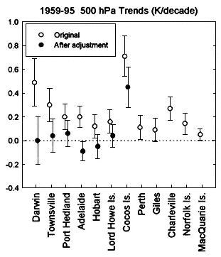
Figure 8.1.
Mid-tropospheric (500 hPA) temperature trends (and their 95% confidence intervals)
at twelve radiosonde stations operated by the Australian Bureau of Meteorology for
1959–1995 (Gaffen et al., 2000; reprinted with permission of the American Meteorological
Society). The temperature data for seven stations were adjusted to account for a 1979 change
in radiosonde instrument type from the Astor Mark I sonde to the Phillips Mark II sonde.
A third approach utilizes statistical methods to objectively identify abrupt shifts, or change-points, in time series. Gaffen et al. (2000) experimented with two different statistical approaches, representing opposite extremes. One, which relies only on statistical identificationcontinue
Page 57
and adjustment of the data, is very liberal in that it cannot distinguish between artificial and natural variability. The other, which incorporates station history metadata, is very conservative in that it adjusts only for artificial changes which are identified with a high degree of confidence. These experiments demonstrate that adjustments for change-points can yield very different time series and trends, depending on the scheme used to make adjustment and the manner in which it is implemented. This is illustrated in Figure 8.1, which shows mid-tropospheric (500 hPa) temperature trends from twelve stations operated by the Australian Bureau of Meteorology (Gaffen et al., 2000). The trends in the original data for the period 1959—95 show warming of between 0.05 and 0.71 °C/decade. The data from seven stations were adjusted due to a step-like warming of approximately 0.75 °C associated with a 1979 change in radiosonde type. The effect of the adjustment is to substantially reduce the trends and in some cases to change the warming to a cooling.
Model-based reanalyses (see the previous discussion on gridding radiosonde data) offer a further potential means of radiosonde temperature bias detection and removal through comparisons with first-guess fields.
Each of these strategies for radiosonde data adjustment, except the last one, depends to some degree on metadata—information about the history of instruments and observing practices at each station. Despite recent efforts to compile and digitize global radiosonde metadata (Gaffen, 1993, 1996), there are gaps and uncertainties in the historical information. Current efforts to collect and maintain metadata archives are minimal and should be enhanced.break


