
Summary
A tsunami is a series of waves that can move on shore rapidly, but last for several hours and flood coastal communities with little warning. Tsunamis can be triggered by a variety of geological processes such as earthquakes, landslides, volcanic eruptions, or meteorite impacts. Since modern record keeping began in 1800, they have taken many lives in Hawaii, Alaska, Puerto Rico, the Virgin Islands, California, Oregon, and American Samoa. The threat of a potentially catastrophic tsunami on U.S. soil looms in seismically active regions in the Pacific and Atlantic (Figure S.1). More recently, tsunamis generated by earthquakes in West Java (July 2006), Samoa (September 2009), and Chile (February 2010) have flooded some U.S. coastlines, highlighting the need for a focused and well-coordinated effort to minimize the loss of life and property.
In the wake of the catastrophic 2004 Indian Ocean tsunami, which caused more than 200,000 deaths and widespread destruction, Congress passed two laws intended to increase efforts to diminish the potential impact of a tsunami. The first P.L. 109-13 in 2005 was aimed at expanding the current tsunami detection system; and the second P.L. 109-424 in 2006 asked the National Oceanic and Atmospheric Administration (NOAA) and the National Tsunami Hazard Mitigation Program (NTHMP) to strengthen the nation’s tsunami detection, warning, education, and preparedness efforts.
At the same time, Congress charged the National Academy of Sciences (NAS) to review the nation’s progress toward the ability to detect and forecast tsunamis. In particular, the committee was asked to review how the expansion of the sea level sensor network has improved the ability to detect and forecast tsunamis; how the tsunami program could be improved; and how well it is coordinated with other efforts. The NAS expanded the scope of the study to also review the nation’s ability to minimize the impact from future tsunamis by educating and preparing the American public. The complete statement of task is provided in Appendix B.
Overall, the committee found that the nation’s tsunami efforts have improved in several ways since 2004. For example, the expansion of the Deep-ocean Assessment and Reporting of Tsunamis (DART) sensor network has improved the ability to detect and forecast the size of tsunamis, the number and quality of hazard and evacuation maps has increased, and several states have assessed the number and types of vulnerable individuals in tsunami-prone areas. In addition, numerous tsunami education and awareness efforts have been initiated.
However, current capabilities are still not sufficient to meet the challenge posed by a tsunami generated close to land (see Box S.1). Near-field tsunamis can reach the coast just minutes after the triggering event—leaving little time to disseminate official warning messages. Tsunami education and preparation is necessary to ensure people are aware of the tsunami risk in their community and know how to recognize natural cues, such as the tremors of a tsunami-triggering earthquake, even if they do not receive an official warning. Communities at a
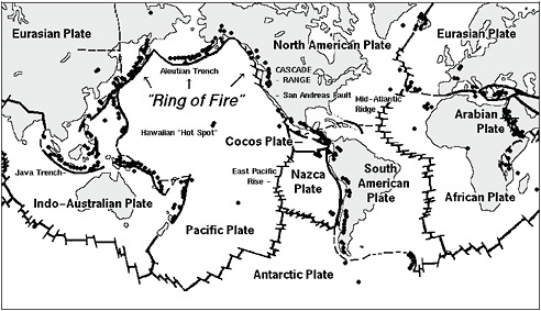
FIGURE S.1 Global map of active volcanoes and plate tectonics illustrating the “Ring of Fire” and depicting subduction zones; both areas associated with frequent seismic activity. SOURCE: http://vulcan.wr.usgs.gov/Imgs/Gif/PlateTectonics/Maps/map_plate_tectonics_world_bw.gif; USGS.
|
BOX S.1 What Is a Near-Field and a Far-Field Tsunami? A tsunami generated close to the shoreline is known as a “near-field” tsunami; a tsunami generated by a source far from the point of impact is referred to as a “far-field” tsunami. In general, it takes a large earthquake (magnitude >7.0) to generate a damaging tsunami in the near-field and it takes a great earthquake (magnitude >8.0) to generate a damaging tsunami in the far-field. Near-field tsunamis pose a greater risk for coastal communities because the first waves can move on shore in minutes. Far-field tsunamis will not reach the coast for hours, and allow time to issue warning and evacuation notices. In some intermediate cases, a tsunami could hit the coast less than an hour after an event at a moderate distance from the coast. In this latter case, the earthquake may not be felt strongly, so warnings and evacuation notices will be essential for an effective response. The implications for detection and disaster warning and response are different for near-field and far-field tsunamis, and each scenario is considered in depth as part of this report. |
greater distance from the triggering event might feel the ground shaking only weakly and not recognize the need to evacuate although a tsunami could arrive in as little as an hour. In this case, detection, forecast, and warning systems would need to operate efficiently, and decision makers at Tsunami Warning Centers and state and local emergency managers would need to coordinate closely to ensure that a clear, consistent message is delivered— a daunting challenge that will require major improvements in all parts of the end-to-end tsunami program.
Considering the many independent and disparate efforts currently ongoing as part of the nation’s tsunami hazard mitigation efforts, the committee concluded that the best way to improve the current end-to-end tsunami warning system would be to define the characteristics of an ideal system that detects and forecasts the threat and coordinates risk assessment, public education, and the response to minimize loss of life and property in the event of a tsunami. Each component (risk assessment, education, detection and forecasting, and warning management) of this idealized system could then be compared against current and planned efforts to identify areas that need improvement.
LAYING THE FOUNDATION: A COMPREHENSIVE NATIONAL ASSESSMENT OF TSUNAMI RISK
Understanding the nation’s tsunami risk1 is the first step to building a comprehensive tsunami preparedness program. The nation is just beginning to define the hazards tsunamis pose, the populations and societal assets they threaten, and the readiness of individuals and communities to evacuate. Although much progress has been made, the nation remains far from understanding enough of its tsunami risk to set risk-based priorities for state and national efforts in tsunami preparedness, education, detection, and warning.
Assessing tsunami risk is challenging: there is a paucity of information about the frequency, source, and characteristics of past tsunamis and their reoccurrence intervals; vulnerability of coastal communities cannot be assessed without considering interdependencies from a larger economic and sociopolitical context; and the potential impacts of future events are uncertain. Although difficult to assess, societal risk from tsunamis is critical information in the development and prioritization of risk-reduction efforts including: education, preparedness planning, warning-system development, mitigation, and response strategies at the local, state, and federal level. The level of sophistication, accuracy, resolution, and format required for assessing societal risk to tsunamis will depend on the intended use of the information.
Recommendation: NOAA and its NTHMP partners, in collaboration with researchers in social and physical sciences, should complete an initial national assessment of tsunami risk in the near term to guide prioritization of program elements.
Tsunami hazard assessments focus on the physical characteristics of future tsunamis, especially on those that can pose a threat to people and the things they value. These characteristics
include the speed of onset, impact forces, currents, and the area that will be flooded. Understanding the hazard also requires an understanding of tsunami sources, for example, how often a coast is likely to have a tsunami and how large of a tsunami a source might generate. A typical tsunami hazard assessment accordingly includes:
-
studies of the locations, sizes, and histories of tsunami sources, which are usually earthquakes but can also be landslides or volcanic eruptions;
-
inundation models, which determine the areas most likely to be flooded;
-
hazard maps, which portray inundation models on maps that show roads, elevation and buildings, and other critical infrastructure; and
-
evacuation maps, which depict areas that need to be evacuated in the event of a tsunami and show evacuation routes to safe havens.
Modeling tsunami inundation begins at the tsunami source with estimates of the seafloor deformation that initiates the tsunami. The simulation also requires accurate information on the topography of the seafloor to understand the surface over which tsunami waves propagate, and a robust computational model to simulate the formation of tsunami waves.
Knowledge of the sizes and recurrence intervals of tsunami-triggering events is only now emerging and is improving the understanding of tsunami sources critical to producing a comprehensive tsunami hazard assessment; but currently, no formal procedures for periodic re-evaluation of tsunami risks exist. The U.S. Geological Survey’s (USGS) National Earthquake Hazards Reduction program serves as an example of a successful and useful approach to periodic national hazard assessments that NOAA and its NTHMP partners could adapt. In particular, the USGS updates the U.S. National Seismic Hazard Maps at six-year intervals nationwide and at other intervals regionally.
Recommendation: NOAA and its NTHMP partners should institute a periodic assessment of the sources of tsunamis that threaten the United States.
The committee concludes that the accuracy and realism of tsunami inundation models is limited by scientific uncertainties in determining the source of tsunamis, limited spatial resolution of bathymetry, a lack of topography data, and difficulties in modeling the complexity of processes that take place when the tsunami wave interacts with buildings and natural features of the coast. Modeling efforts would greatly benefit from a rigorous vetting process, peer-review, and validation with field data.
Recommendation: To improve tsunami inundation modeling, the NTHMP should periodically review progress in hydrodynamic modeling.
Moreover, the committee found that the development and use of inundation models is not occurring in a coordinated or standardized fashion across the NTHMP. Instead, each member state independently selects the tsunami source, bathymetric and topographic data, and numerical code. Although state resources are used to leverage federal resources, this state-by-state based approach to tsunami inundation mapping, coupled with inadequate coordination
and consensus among NTHMP modelers and no external peer review, has created significant disparities in the methods, criteria, and judgments employed in tsunami inundation modeling and the resulting hazard maps that are based on these models.
Recommendation: The NTHMP should reduce unnecessary and costly disparities in inundation modeling approaches among states and territories. The NTHMP should conduct modeling efforts consistently across political boundaries and execute efforts through a cooperative partnership among NOAA, the USGS, and NTHMP members.
Evacuation maps are critical tools for preparing and educating the public about the hazard and the appropriate response before an impending tsunami. For most at-risk communities, the committee concludes that progress has been made toward generating improved evacuation maps. However, methods to produce evacuation maps vary greatly among NTHMP member states; that means at-risk populations must try to interpret different representations of tsunami risk. Due to the absence of uniform quality standards, evaluative metrics, or guidelines on effective approaches, the committee found it difficult to assess whether current evacuation maps are sufficient for enabling effective evacuations or preparing the public.
Recommendation: The NTHMP Mapping and Modeling Subcommittee should develop guidelines on evacuation-map production that fosters consistency in format and quality across the United States, and a national, online repository for tsunami evacuation maps.
Tsunamis pose risks only if they have the potential to impact people or the things people value. Therefore, a first step in understanding vulnerability is to inventory the number and characteristics of individuals in tsunami hazard zones. In addition, emergency managers should assess their demographic characteristics, as these can affect an individual’s ability to receive, understand, and respond to warning messages. For example, the very young and very old may need evacuation assistance and thus have higher sensitivity to tsunami hazards. Currently, there is no national assessment of population exposure and sensitivity to tsunamis, including the number and types of individuals in tsunami hazard zones. This lack of information limits abilities to assess national tsunami risk, develop realistic evacuation plans, and tailor education efforts to at-risk individuals.
Recommendation: The NTHMP should periodically inventory the number and type of people in tsunami hazard zones, with special attention to groups whose heightened sensitivity to tsunamis could constrain their ability to prepare for and evacuate from future tsunamis. The NTHMP should provide guidelines on how to use this information to tailor evacuation planning and education efforts.
Many communities in the United States are threatened by near-source tsunamis, but few evacuation studies have been conducted to evaluate the ability of at-risk individuals to reach higher ground before tsunami waves arrive. For example, local earthquakes that generate near-source tsunamis have the potential to impact roads, infrastructure such as bridges, or facilities essential for response efforts. Preparedness efforts would greatly benefit from assessing how these earthquake damages impact the ability to evacuate. Without such information, emer-
gency managers are not able to identify where targeted outreach and evacuation assistance will be needed.
Recommendation: For all communities with near-source tsunami threats, the NTHMP should conduct evacuation modeling studies to assess the likelihood of successful evacuations.
PREPARING IN ADVANCE THROUGH A CONSISTENT PUBLIC EDUCATION CAMPAIGN
Surviving a tsunami depends on the ability of an individual in the hazard zone to recognize warning signals, make correct decisions, and act quickly. For near-field tsunamis, waves will arrive within minutes after generation; therefore, at-risk individuals will need to recognize natural cues such as the ground shaking or the receding of the water line as the primary warning. Knowledge and readiness gained through pre-event education may save lives. For far-field tsunamis, waves will arrive several hours after generation, and individuals need to understand official warnings and follow instructions given by local agencies. Regardless of the tsunami source, integrated public education and preparedness planning are necessary to protect lives and to make tsunami knowledge commonplace and ingrained into local culture and folk wisdom.
Educating At-Risk Individuals
Tsunami education in U.S. coastal communities is a major challenge because it requires reaching hundreds of coastal communities with hundreds of thousands of residents, employees, and tourists. The NTHMP Mitigation and Education Subcommittee is charged with assessing tsunami education needs for the nation, addressing these needs through targeted products and activities, and then sharing these products with other at-risk coastal areas.
Tsunami outreach and educational programs can draw from a rich base of research on enhancing hazard education to motivate the public to prepare for future hazards. For example, research has shown that training campaigns and the dissemination of education products are more effective when tailored to the strengths and vulnerabilities of specific communities. A campaign designed for long-time residents would capitalize on familiarity of the surroundings, as well as emphasize household preparation strategies and the importance of creating community networks. In contrast, a program designed for tourists and other transient populations would focus on easily identifiable landmarks, would provide information via signs posted in prominent locations, and would train hotel and tourist services staff such as tour guides, life guards, and vendors to provide assistance to tourists.
The committee was requested to review the availability and adequacy of tsunami education and outreach. One obstacle to this task was that no systematic evaluation of U.S. tsunami education efforts has been conducted at a national scale. No compilation or inventory of
NTHMP-related tsunami efforts was available at the time of this review, although it is a current goal of the NTHMP. A second obstacle is a lack of pre- and post-outreach evaluations and post-event assessments. Because there are few studies that documented the perceptions, knowledge, and capacity to prepare at-risk populations, there are no consistent baselines or metrics to gauge the effectiveness of education programs.
The committee concludes that current tsunami education efforts are not sufficiently coordinated and run the danger of communicating inconsistent and potentially confusing messages.
Recommendation: To increase the effectiveness of tsunami education, the NTHMP should
-
develop consistent education efforts among its members using evidence-based approaches,
-
tailor tsunami education to local circumstances,
-
create and maintain an online repository of education efforts,
-
develop and implement an evaluation program of the effectiveness of education efforts, and
-
leverage hazard-education efforts and expertise of other NOAA entities.
Because pre-event education is critical to saving lives during a near-field tsunami, the committee concludes that tracking progress in education and outreach efforts in communities threatened by near-field tsunamis is a high priority.
Recommendation: The NTHMP should prioritize systematic, coordinated perception and preparedness studies of communities with near-field tsunami sources to determine whether at-risk individuals are able to recognize natural cues of tsunamis and to take self-protective actions.
Preparing Communities
Because of the breadth and diversity of actions that could be taken to increase preparedness, the committee restricted its review of community preparedness to NOAA’s TsunamiReady Program, which has emerged in recent years as a framework for improving tsunami preparedness in coastal jurisdictions. TsunamiReady is a voluntary program that aims to help communities reduce the potential impacts from tsunami-related disasters through redundant and reliable warning communications, better preparation through community education, and official readiness through formal planning and exercises. It sets minimum guidelines, such as having the ability to communicate warnings to the local population, and encourages consistency in educational materials. Traditionally, the program has measured its success by the number of communities recognized as TsunamiReady annually. However, the committee questions the effectiveness of the program and its success criteria, because the program lacks the following elements:
-
a professional standard to guide its development,
-
metrics to assess baseline readiness and community needs,
-
evaluative criteria to assess community performance during a tsunami,
-
accountability measures to ensure recognized communities meet and continue to meet mandatory requirements,
-
local points of contact with training in community preparedness, and
-
criteria and guidance on what constitutes effective public outreach and preparedness efforts.
The Emergency Management Accreditation Program (EMAP) aims to improve community preparedness for natural hazards. Unlike TsunamiReady, EMAP is more broadly geared to all-hazards mitigation. EMAP is the nationally recognized standard for emergency management and provides criteria to assess current programs or to develop, implement, and maintain a program to mitigate, prepare for, respond to, and recover from disasters and emergencies. Its process for accreditation is transparent and applied through peer review. Because TsunamiReady’s current requirements are not well structured and do not fit the concept, terminology, and format of a standard, the program could improve by drawing on EMAP’s well-established standard, process, and experience with the emergency management community.
Recommendation: The NOAA Tsunami Program could strengthen the TsunamiReady Program by modeling it after the Emergency Management Accreditation Program.
Developing and Delivering Effective Warning Messages
The likelihood of individuals responding to tsunami warnings depends on the quality, clarity, and accuracy of the official warning messages they receive from the two Tsunami Warning Centers (TWCs) and/or local and state emergency management agencies. An effective message contains the necessary information to motivate individuals to take self-protective action and must reach at-risk people in a timely fashion. It is critical that warning messages: are accurate and consistent; use language that allows a person to visualize the proper response; make clear when recommended actions should begin and finish; identify who needs to evacuate and who does not; and explain how taking the protective action will reduce the pending consequences of not taking action at all.
Currently, both the TWCs issue a tsunami warning, advisory, watch, and information statement through multiple official channels following detection of a tsunami-triggering event. It then becomes the responsibility of local or state officials to take the appropriate actions and issue their own messages and evacuation orders to individuals in tsunami-prone areas. The generation of two different tsunami warning messages has created confusion among the media, some local officials, and the general public, and will likely continue to do so unless message content is improved or a single message is issued.
Recommendation: If distinct messages are to be produced by the two TWCs, then the messages should be consistent. Ideally, the committee recommends that one message be released by the two TWCs that includes information for all areas under their responsibility.
Recommendation: The NOAA/National Weather Service (NWS) should better integrate the TWC warning functions with the state, county, and city warning functions with regard to message content and dissemination methods for the public by developing formal TWC outreach plans and assessing needs and priorities of TWC customers.
Coordinating Across All Levels of Government
State working groups, regional groups, and the NTHMP facilitate the coordination and planning across jurisdictional boundaries, including the coordination of educational efforts and opportunities to provide feedback to the TWCs on warning messages. These efforts are valuable in contributing to pre-event planning and coordination, but they could be strengthened through additional exercises and drills focused on improving evacuation procedures during an event.
Current efforts to practice evacuation procedures and protocols include community-led evacuation drills, live code “end-to-end” tests, table-top exercises among emergency management agencies, and functional exercises to test interagency communication and coordination. The committee concludes that the importance of these approaches vary based on local conditions and tsunami threat, and include specific conclusions for both far-field and near-field tsunamis.
-
Far-field tsunami threats: Evacuations will be managed by multiple agencies over many hours; therefore, exercises are important to engage agencies to discuss and test coordination and communication. However, the committee concludes that evacuation drills are not advisable because of the risks associated with such drills, especially in larger communities.
-
Near-field tsunami threats: Initial evacuations will be self-directing after at-risk individuals recognize natural cues. The committee concludes, however, that table-top and functional exercises are still important because of the significant response and relief operations after the initial tsunami wave arrives. The committee concludes that these community-led, voluntary drills may be useful in promoting tsunami awareness, providing social cues, and building social networks but only in small communities that have limited vertical-evacuation options and may have less than 30 minutes to evacuate.
Recommendation: The NTHMP should actively encourage member states to develop and maintain active tsunami working groups to help facilitate and coordinate tsunami education, preparedness, and warning dissemination.
Recommendation: To ensure that managed evacuations for far-field tsunamis are effective and minimize societal and economic interruptions, the NTHMP should develop guidelines on the design of effective exercises for use by emergency management agencies.
Considering their multiple responsibilities and limited resources, the TWCs should be commended for their commitment to establishing connections with external groups and coordinating their efforts. However, relatively few staff resources have been dedicated to maintaining partnerships with customers, and existing efforts are secondary to the technical aspects of the warning centers. There are no formal outreach plans for media training or working with emergency management and response personnel, no formal training interaction for TWC watchstanders and state emergency management officials, and no formal standard operating procedures for evaluating the effectiveness of warning message content or channels. Retrospective reviews could enhance the effectiveness of the ongoing educational efforts and guide further improvements in community preparedness and coordination among decision makers.
Recommendation: After a significant tsunami warning is issued to U.S. communities (e.g., the 2010 Chilean event), the NOAA/NWS should initiate an independent review of TWC actions and its integration with its partners and customers through an external science review board and make findings public.
DETECTING AND FORECASTING TSUNAMIS
The two separate Tsunami Warning Centers monitor seismic activity to assess the potential for tsunami threats from earthquakes. The content of the first tsunami information statement, advisory, watch, or warning from the TWC is decided solely on seismic parameters and the historical record, if any, of past tsunamis generated in the area of the earthquake. Based on their own data analysis, the TWCs independently decide whether to issue alerts to the emergency managers in their respective areas of responsibility. This initial statement can be issued within 5-10 minutes after the earthquake is detected and might provide communities near the source with the only alert, if waves reach shore within minutes. However, this indirect seismic method has limited accuracy in its estimates of the strength of the tsunami. Because forecasters must err on the side of caution when human lives are at stake, the TWCs use conservative criteria for issuing advisories, watches, or warnings, which can lead to unwarranted evacuations costing millions of dollars.
Data from coastal sea level gauges and the open ocean DART network provide the only means to verify the existence of a tsunami and to forecast the height of the tsunami waves as they spread from the source. This information is used to adjust or cancel warnings, watches, and advisories. Coastal and open ocean sea level sensor networks can also detect tsunamis from sources that fail to generate seismic waves. Although the detection of the open ocean signal can occur within the first hour after the tsunami, forecasts might take longer. Thus, only communities farther from the tsunami source will benefit from these refined warning messages.
The committee concludes that the global networks that monitor seismic activity and coastal and open-ocean sea level variations remain essential to the tsunami warning process. The current global seismic network is adequate and sufficiently reliable for the purposes of detecting likely tsunami-triggering earthquakes. However, because the majority of the seismic stations are not operated by the TWCs, the availability of this critical data stream is vulnerable to changes outside of NOAA’s control.
The complex seismic processing algorithms used by the TWCs, given the availability of seismic data, quickly yield adequate estimates of earthquake location, depth, and magnitude for the purpose of tsunami warning. However, the methodologies are inexact, in part because of the physically variable nature of tsunamis, and in part because of the need for rapid determination of earthquake parameters that may not be definitive until the entire rupture process is complete (potentially tens of minutes). In the case of a very large earthquake the initial seismological assessment, although adequate for most medium-sized earthquakes, can underestimate the earthquake magnitude and lead to errors in assessing tsunami potential. In parallel to their own analyses, staff at the TWCs could avail themselves of earthquake locations and magnitudes that are estimated within minutes of an event from the USGS National Earthquake Information Center (NEIC). An interagency agreement could be established to make these initial estimates available on secure lines between the USGS and NOAA.
Recommendation: NOAA and the USGS could jointly prioritize the seismic stations needed for tsunami warnings to advocate for the upgrade and maintenance of the most critical stations over the long term.
Recommendation: The TWCs should work jointly with NEIC to test the utility of the W-phase algorithm in the tsunami warning process, using both a sufficient dataset of synthetic seismograms and a set of waveforms from past great earthquakes, paying particular attention to the algorithm’s performance during “tsunami earthquakes” and to the assessment of a lower-magnitude bound for its domain of applicability.
Detection of Tsunamis with Sea Level Sensors
A majority of the funds authorized by the Tsunami Warning and Education Act (P.L. 109-424) have been used to manufacture, deploy, and maintain an array of 39 DART stations, establish 16 new coastal tide gauges, and upgrade 33 existing water level stations. These new and upgraded sea level stations have closed significant gaps in the sea level sensor network that had left many U.S. coastal communities subject to uncertain tsunami warnings. The availability of these open-ocean DART stations makes it possible to forecast the height of tsunamis once waves are detected by the buoy and before they arrive onshore.
However, some fundamental issues remain. For example, gaps in coverage exist in the Caribbean region or off the South America coast. Most concerning is the committee’s finding that as much as 30 percent of DART stations are inoperable at any given time. These high
numbers for buoy outages jeopardize the ability of the TWCs to forecast tsunamis. Because the value of individual components in the network and the risk to the warning capability due to individual component failures has not been evaluated, the National Data Buoy Center (NDBC) has no guidance for high-priority buoy repairs.
Recommendation: The reliability of the DART network should be improved to allow the TWCs to fully utilize the capability this technology offers.
Recommendation: In order to bring NDBC into compliance with P.L. 109-424, the center should engage in a vigorous effort to improve the reliability of the DART stations and minimize the gaps caused by outages.
Recommendation: NOAA should regularly assess the appropriate spatial coverage of the coastal and DART sea level sensor network (U.S. and international).
Recommendation: NOAA should prioritize the sea level stations (both U.S. and international) according to their value to tsunami detection and forecasting for the areas of responsibility of the TWCs.
Recommendation: NOAA should assess on a regular basis the vulnerabilities to, and quality of, the data streams from all elements of the sea level sensor networks, beginning with the highest priority sites determined per the recommendations above.
Recommendation: NOAA should encourage access to the DART platform by other observational programs, because the platform presents an opportunity to acquire a long time series of oceanographic and meteorological variables.
Recommendation: NOAA should establish a “Tsunami Sea Level Observation Network Coordination and Oversight Committee” to oversee and review the implementation of the recommendations provided above.
Tsunami Forecasting
The expansion of the coastal and open-ocean sea level network has made it possible to forecast tsunamis in near-real time. It provides emergency managers with critical information about the time the first wave might arrive, the duration during which waves will continue to arrive (which can be for many hours), and the size of these waves. Currently, one forecast model is fully operational and one is being used by the TWCs as an additional source of forecast model output. Although these models have been relatively successful in forecasting recent events, a more open and transparent process is needed to evaluate model performance and how the results of the two models can be used to improve the results. For example, the
National Hurricane Center (NHC) runs ensemble models to take advantage of several model outputs to create a single product for the forecast. Tsunami forecasting would benefit from the development of a process that identifies (1) benchmarks to evaluate model performance, (2) how different solutions can be used to create a single forecast, and (3) how field data can be used to validate and improve the models.
Recommendation: Both the TWCs and the NOAA Center for Tsunami Research should continue to work together to advance current forecasting methodologies and bring all available methodologies into full operational use.
Future Research and Technology Development
Currently, given the distance of the source to the closest coastal or open-ocean sea level sensor, it can take up to an hour or more to confirm a tsunami forecast and potentially even longer to forecast the size. This is not only of concern in the case of near-field tsunamis, but also in the event of a tsunami earthquake or underwater landslide, events that generate only a small amount of ground shaking but could trigger a tsunami of much greater amplitude than would be expected. In this circumstance, official warnings may be the only way to notify people. An example comes from the Meiji Sanriku tsunami of 1896 in northeast Japan. The earthquake was large (magnitude 7.2) but generated such weak ground shaking that few people were concerned about the potential for a tsunami. More than 22,000 people perished in the huge tsunami that followed.
To detect a tsunami earthquake or underwater landslide, direct measurements of the water-surface variations and currents are required in real time. This rapidly sampled data could also help issue warnings to communities a little farther away from the source. Infrastructure such as sea level sensor networks and communications equipment could be destroyed by the initial impact of the tsunami wave, leading to a lack of official warnings.
One way to accomplish real-time measurements is to collect data using cabled seafloor observatories. These comprise various sensors connected to each other and to shore by a seafloor communications cable that serves both to deliver power to the sensors and to transmit data from the sensors back to onshore data servers. Several types of instruments are useful for tsunami detection, including bottom pressure sensors, seismometers, current meters, and accelerometers. Observatories currently in operation include the North-East Pacific Time-Series Underwater Networked Experiments (NEPTUNE) Canada, off the coast of British Columbia and the Monterey Accelerated Research System (MARS) in Monterey Bay, California. Another large U.S. observatory, the Ocean Observatories Initiative (OOI), has been funded by the National Science Foundation (NSF) for deployment across Oregon’s continental shelf, slope, and the Cascadia Subduction Zone, over the Juan de Fuca plate, and on the Juan de Fuca Ridge. The committee concluded that tsunami detection, warning, and preparedness activities for near-and mid-field tsunamis could benefit from the expansion of existing alternative technologies for real-time detection.
Recommendation: To develop more rapid and accurate warnings of local tsunamis, the TWCs should coordinate with the NEPTUNE-Canada and OOI observatory managers to obtain access to their seismic and bottom pressure data in near-real time. Data interpretation tool(s), jointly applied to the seismic and bottom pressure data, should be developed to realize the most rapid tsunami detection possible.
Another promising area of research that could improve the ability to more rapidly predict the magnitude of a tsunami comes from Global Positioning System (GPS) measurements. In combination with seismic data, continuous GPS measurements have proven to be powerful in studying continental earthquakes such as illuminating the processes of earthquake after-slip. Continuous GPS can provide a map of the three-dimensional deformation of the earth’s surface as a result of the earthquake rupture. This information can be used to help predict tsunami generation and provide accurate forecasts of wave heights.
The use of GPS holds great promise for extending the current seismic networks to include capabilities for measuring displacements in the coastal environments for the large earthquakes that can be underestimated using seismic techniques alone. Displacements onshore could potentially be used to infer offshore displacements in times as short as five minutes in an area such as the Cascadia fault zone.
Recommendation: NOAA should explore further the operational integration of GPS data into TWC operations from existing and planned GPS geodetic stations along portions of the coast of the U.S. potentially susceptible to near-field tsunami generation including Alaska, Cascadia, the Caribbean, and Hawaii. Where GPS geodetic coverage is not adequate, NOAA should work with NSF and the states to extend coverage, including the long-term operation and maintenance of the stations.
The report identifies several other areas of research and technology development that have the potential to improve the nation’s ability to detect, forecast, and provide timely and accurate warnings regarding tsunamis. For example, the seismic analysis could be improved using high-frequency P-waves. In addition, satellite altimetry or island seismometers might be used to detect tsunami waves, or GPS satellites could detect tsunami waves in the atmosphere. These research avenues hold promise but are far from becoming operational in the tsunami detection and warning process.
Regular, independent scientific review of the various elements of the tsunami warning system would be valuable in identifying and addressing research needs and in ensuring the effective implementation of new technologies and protocols. Science needs to be brought to bear more systematically across the spectrum of tsunami preparation, education, detection, and warning systems. The establishment of an external science advisory panel consisting of physical and social scientists, and practitioners in emergency management, is one option to provide advice and oversight across the spectrum of tsunami efforts.
IMPROVING TSUNAMI WARNING CENTERS’ RELIABILITY AND SUSTAINABILITY OF OPERATIONS
The TWCs provide services to a wide community that includes emergency managers, the scientific community, and the public. They are responsible for gathering information from sensor and observational systems, detecting tsunamigenic earthquakes, developing decision support information, and providing and disseminating warnings to the public and other entities. Although operational procedures for earthquake detection are similar at both TWCs, the technologies used are considerably different, with different hardware platforms, software suites, processes, and interfaces to the public and their users. The committee concludes that these differences lead to technological incompatibilities and limited capabilities for back up, redundancy, and checks and balances, which are important mission capabilities for the tsunami warning system.
The success of the TWC mission is critically dependent on technical infrastructure and human capital, both of which the committee assessed to be insufficiently supported. Several issues have been identified that are associated with the reliance on dated software technology hampering easy interfacing with current network and mobile data structures. Addressing these problems is difficult for the TWCs, as most scientific personnel and watchstanders have training in the geophysical sciences and not in software engineering.
To harmonize software and hardware suites, NOAA developed an information technology (IT) Convergence Plan, with the goal of creating a single, platform-independent technology architecture to be deployed at each TWC and a shared tsunami portal. The committee believes that the NOAA’s IT Convergence Plan is well-motivated, but it notes that the plan is a single project effort and is not part of a systematic, comprehensive IT system plan and enterprise architecture.
Recommendation: The NOAA/NWS should harmonize and standardize checklists, tsunami warning products, and decision support tools, and it should use standard TWC software tools and applications.
Recommendation: Given the importance of IT and the rapid evolution of IT, the tsunami warning program should undertake a comprehensive, enterprise-wide long-range technology planning effort, consistent with international technology process and product standards, in order to develop both an enterprise-wide technology architecture for TWC operations and the accompanying enterprise-wide technology support processes.
As part of this long-range planning effort NOAA/NWS should:
-
consider providing the TWCs with stronger IT commitment and leadership, and greater resources for software and hardware personnel, planning, development, operations, maintenance, and continuous process and product improvement.
-
provide sufficient IT staff to the TWCs so that IT hardware and software design, development, and maintenance are not a collateral duty of a watchstanding scientist, as is the case presently.
-
adopt national, and where applicable, international, standards, best practices, and lessons learned for all functions, technology, processes, and products.
-
regularly and systematically apply continuing process and product improvement models for hardware and software planning, development, operations, and maintenance and for organizational processes; and develop a learning organizational culture.
The committee reviewed the pre-written messages delivered by the TWCs and found that many documented principles for effective warning messages have not been applied. The committee concluded that the centers’ warning products would be much more effective if their content and delivery incorporated the latest social science on composing effective warning messages and were compatible with current software, hardware, and social media.
Recommendation: The TWCs should consider alternative warning message composition software and should improve protocols by undertaking an external review by IT specialists in the area of communication technology to identify the latest technology in message composition software and formats to ensure compatibility with current and next generation information and communication technology for message dissemination.
The committee also found inconsistencies between the warning products of the TWCs and those of the NWS. For example, a watch means that an event has an 80 percent chance of becoming a warning in the NWS, but this is not the case with the TWCs whose watches rarely become warnings. Another current inconsistency is how the TWCs and the NWS deal with “all-clears.” The TWCs cancel a bulletin, which could be read by the public as a signal that it is safe to return, which is not the same as an “all-clear” issued by the NWS. The NWS will soon move from using the “alert bulletin system” to an “impact based system,” which will introduce another inconsistency with the TWCs.
Recommendation: Current and future adjustments of TWCs and NWS warning products should be made in a consistent fashion. A mechanism should be put in place so that future changes in warning products are quickly reviewed for inconsistencies, which are then addressed, so that products from the TWCs and the NWS match.
Human Resources
Each TWC relies on a dedicated staff, including nine science duty officers that perform watchstanding duties in addition to research and development. The watchstander has a critical role in tsunami decision support by maintaining situational awareness and issuing correct notification and warning products. Although visualization software assists by monitoring seismic and sea level data and mapping event locations, it is the watchstanders’ training, experience, and expert judgment that are essential in making the appropriate decisions when creating warning products. To enhance the effectiveness of TWC decision making and the TWC staff’s ability to inform decision making processes, regular and varied types of training are needed. In addition, because of the importance of technical and scientific know-how within
the TWCs, opportunities for interactions between TWC staff and external scientific and professional communities are important and need to be encouraged and institutionalized within the tsunami program.
Recommendation: Because of the importance of technical and scientific expertise to the TWC’s function, TWC human capital requirements, recruiting, training, re-training, development, mentoring, and professional exchange should be included, reassessed, and updated as part of the NOAA/NWS enterprise-wide technology planning effort.
Organizational Structure
The goal of having two geographically distributed TWCs in Hawaii and Alaska with distinct areas of responsibility is to provide the system with backup in the case of critical failure at the other center. However, there are significant differences in IT architecture and software suites that thwart this backup function. Also, inconsistencies in warning products issued by the two TWCs have caused confusion. Because clear communication and consistency in message content are two key principles to effective warning message composition, the TWCs’ warning products are less effective in eliciting the appropriate response. Because the TWCs are managed by two different regional NWS offices, use different analytical software and hardware, and appear to have distinct organizational cultures, the committee concludes that they do not function as redundant systems. Significant organizational changes will be needed to allow them to truly function as redundant systems that provide true backup capabilities. The committee considered the following options to address shortcomings of the current structure of the TWCs: harmonizing the two TWCs’ operations, merging the two TWCs into a single center, or co-locating one or more TWCs with other research or forecasting units.
Recommendation: Organizational structures for the two TWCs should be evaluated and fully described as part of an enterprise-wide technology planning effort. Whether there should be a single or multiple TWCs, or whether the TWC operations should be consolidated in a different location, should be addressed during the enterprise-wide long-range planning effort.
Conclusions
The numerous distributed efforts in tsunami detection, warning, and preparedness are linked together to reduce loss of life and economic assets from a tsunami. In the event of a tsunami, all these distributed efforts must come together in less than a day to produce an effective, adaptable response and function like a single organization. A challenge for tsunami warning preparedness efforts is to develop effective organizational structures that provide reliable and sustainable operations in non-tsunami periods as well as during catastrophic incidents, especially given the short time available to respond in a crisis.
The committee found that personnel responsible for these efforts (e.g., at the TWCs and Tsunami Program, state emergency managers, etc.) are highly committed to serving each of the program’s functions, from detection through education and community outreach. However, the committee found many shortcomings of the TWCs in terms of function, technology, human capital, and organizational structures, and many opportunities for significant improvements in center operations. Improvements will depend upon an organizational culture change within the NOAA/NWS Tsunami Program that supports and celebrates operational excellence, adopts national and international standards, processes, best practices, and lessons learned for all functions, technologies, processes, and products, and continuously seeks process improvements.
Recommendation: Tsunami warning system processes and products should reflect industry best practices, as well as lessons learned from other operational real-time, large-scale, mission-critical distributed systems, and should comply with international information technology and software engineering product and process standards.
Recommendation: NOAA/NWS and the TWCs should undertake ongoing, joint or NOAA-wide, continuous process improvement activities for their functional, technological, organizational, and human capital initiatives.


