
Page 15
1
Introduction
The Earth's cryosphere—that portion of the planet where water is perennially or seasonally frozen as sea ice, snow cover, permafrost, ice sheets, or glaciers—is especially sensitive to climate change. Thus, scientists often study the cryosphere to learn more about past climate events, understand current weather, and project future climatic changes. Understanding cryospheric processes requires the capability to observe, measure, and understand the variability exhibited by major ice sheets and hemispheric patterns of snow and sea ice extent. To diagnose and predict climate change, climate and hydrologic models need adequate representation of cryospheric processes (e.g., phase changes from solid to liquid) and interactions.
In the past, unprocessed satellite data of relevance were abundant, but little of the data was processed into useful geophysical data sets (products). To address this challenge, the National Aeronautics and Space Administration (NASA)—in partnership with the National Oceanic and Atmospheric Administration (NOAA), the United States Geological Survey (USGS), and the Environmental Protection Agency (EPA)—initiated the “Early Earth Observing System Pathfinder Data-Set Activity” in 1990. The Pathfinder Program was established to develop remote-sensing data sets to support global change research and to enable NASA to gain experience in reprocessing and transferring large data sets between national and international research facilities. Pathfinder data sets consist of long time series of global and regional data as well as higher-level data products generated by NASA and other federal agencies. Some of these products
Page 16
BOX 1-1POLAR PATHFINDER DATA SETS
There are three major NASA/NOAA Pathfinder data sets with significant relevance to the polar regions: 1. Advanced Very-High-Resolution Radiometer (AVHRR) Global Area Coverage, which measures global vegetation, radiance, sea-surface temperature, and clouds and aerosol data; 2. Television Infrared Observing Satellite Operational Vertical Sounder, which produces level-3 (gridded to 100 km boxes), daily-averaged atmospheric data, such as temperature and moisture profiles, surface skin temperature, cloud fraction and height, bulk boundary layer parameters, and surface pressure; 3. Special Sensor Microwave/Imager, which produces hydrology, ocean, snow, and ice data. Other Pathfinder activities are the joint NASA/USGS/EPA LANDSAT Pathfinder, which includes land-cover data, and the NASA Scanning Multispectral Microwave Radiometer (SMMR). Each Pathfinder activity had a designated science working group responsible for identifying needed products, algorithms, and user services. Research teams coordinate all data sets based on a common map projection and use consistent file-naming conventions and validation methods. |
have important significance for climate research in the polar region (Box 1-1).
Pathfinder data sets and derived products are made available to researchers through the Distributed Active Archive Centers (DAACs). The National Snow and Ice Data Center (NSIDC), a component of the DAACs, distributes the polar Pathfinder data sets to the scientific community as part of its many responsibilities related to cryospheric research. In parallel to the polar Pathfinder program, a related group of data sets is being developed through the Polar Exchange at the Sea Surface (POLES) and RADARSAT Geophysical Processing System (RGPS) projects.1
1 The POLES project is an interdisciplinary effort to look at the polar processes that influence the global heat and hydrological cycles; it combines satellite and in situ data in collaboration with the polar Pathfinder Program to create a complementary data set to explore complex physical processes in the polar regions. The RGPS polar products measure geophysical quantities such as sea-ice motion and the thickness distribution of thin ice using Synthetic Aperture Radar archived at the Alaska SAR Facility.
Page 17
Together, the Polar Pathfinder products, POLES products, and RGPS images are a significant source of satellite data for the polar research community.
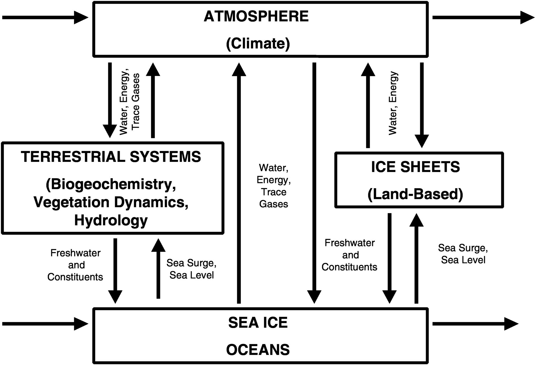
The term “polar geophysical data sets” is used here to indicate any data set that has some special relevance to understanding the most important questions being addressed by current Earth system research in polar regions. Examples of such questions include: How are changes in polar ice sheets reflected in global sea level? How will changes in climate affect hydrologic processes at high latitudes and hence affect such features as ice sheet mass balance and thermohaline circulation? What will be the effects of changes in permafrost, Arctic tundra, boreal forest, and polar oceans on the concentrations and flux of radiatively active gases in the atmosphere? Figure 1-1 depicts the main systems of interest to polar scientists and the relationships among them.
The scope of the present review does not include geophysical problems in the solid earth nor in the upper atmosphere. The important ozone/UV issue, for example, is not addressed here. Our decision to narrow the scope in this way was based on the charge to the committee and on the need to focus our efforts on the primary thrusts of NASA's Polar Program.
PURPOSE OF THIS STUDY
NASA invests significant resources in collecting data sets that serve the science community, but those data sets can only be judged “successful” if scientists use them effectively. To assist in planning how data sets will support polar science in the future and how data products may best be tailored to support the Earth Science Enterprise program, NASA asked the National Academies for guidance. In response, the Committee to Review NASA's Polar Geophysical Data Sets was created to review NASA's strategy for providing derived geophysical data sets to the polar science community. This report provides a brief review of the strategy, scope, and quality of existing polar geophysical data sets; suggests ways to make these products and future polar data sets more useful to researchers; and considers whether the products are reaching the intended communities. Specifically, the committee was charged to:
1. assess the general scope and quality of the polar data sets and determine whether, as a whole, these support the needs of the polar research community.
2. evaluate the strategy NASA uses to develop and disseminate the polar data sets.
3. recommend improvements to NASA's strategy for providing data
Page 18
~ enlarge ~
FIGURE 1-1 Main global systems where NASA geophysical data sets provide important information to polar scientists.
Page 19
sets that support the goals of NASA's Earth Science Enterprise Program, taking into consideration current capabilities, existing infrastructure, and cost-effectiveness.
4. evaluate, as time and resources allow, individual polar data sets and products at the NSIDC and Alaskan SAR Facility to determine whether they can be improved or modified to better support the community.
METHODS
To gather the information needed to address these tasks, the committee's members relied on their own experiences working with geophysical data sets and input from a wide variety of others involved in either collecting, managing, or using polar data sets and products. The committee established liaisons with the DAACs and relevant user groups, and these representatives made presentations and provided information to the committee. An important aspect of this study was a Web-based survey that drew responses from more than 100 scientists (see Appendix B). The survey gathered opinions about the strategy, scope, and quality of existing polar geophysical data sets and ideas for improving future products. Respondents described their general areas of research and the data sets they used; noted if they did not use NASA data sets and why not; offered opinions on the quality and ease of access; and noted whether there were any data sets they wished were available. The committee considered this information as it wrote this report, and some comments on the responses appear in Appendix B.
The committee interpreted its charge as providing an assessment of current NASA polar geophysical data set products and recommendations to guide future decisions about the products. Rather than assess the details of specific data sets, the committee took a broad approach and based its assessment on the science questions outlined in the Earth System Enterprise program (NASA, 1988) adapted to focus on the cryosphere. Chapter 2 is an assessment of the status of polar geophysical data products, including results of the survey of data users. Chapter 3 develops a list of science questions, including the committee's assessment of the data required to address each science question. Chapter 4 assesses the adequacy of existing polar geophysical data products for addressing the science questions. Chapter 5 provides an assessment of major gaps in the polar data products, suggests improvements to the general strategy on polar data sets, and addresses the effectiveness of the DAACs.
While the ESE science-driving questions provide a framework for assessing what additional measurements are needed, a recurring theme of the report is the importance of mining as much information as possible from the existing record of satellite data, which extends back for 20 years
Page 20
for some sensors. Existing satellite data provide a powerful resource for understanding how and why the polar regions have experienced such large changes in recent decades. New EOS-era sensors will fill in some details, to be sure, but data records from these sensors for studying change will not be available for many years, if they indeed receive continued support for “long-term” monitoring. Various recommendations in Chapter 5 focus on the use of existing data sets in the more general contexts of ESE science and change detection, and also in the more specific context of NASA's DAACs and their provision of useful data sets to the science community.


