
programs and projects. The purpose of these visits is for both information exchange and coordination.
In the opinion of the committee, coordination with state surveys could be improved if contact were made in the formative stage of project and program development rather than after a project has been approved. However, the committee believes it is equally imperative for the state surveys to keep the USGS informed of their geologic mapping projects at an equivalent stage in development. It is only through open discussion of programs and projects in their formative stages that the potential for cooperation can be fully realized.
Coordination with Universities
The committee determined that the USGS has no well-defined program to involve colleges and universities in geologic mapping activities. What support has been provided to universities for mapping and related research has been sporadic and subject to the vagaries of changing USGS budgets, priorities, and mandates, as interpreted at district levels. The support has generally been in the form of temporary appointments for students or faculty and rarely in the form of research grants to faculty comparable with those given on a competitive basis by the NSF and by the USGS Earthquake Program. Nonetheless, a significant amount of geologic mapping is being done through colleges and universities. Such activity, if coordinated with and supported by the USGS, could enhance USGS programs by utilizing an untapped reservoir of competent and willing talent pool.
STATUS OF GEOLOGIC MAPPING IN THE UNITED STATES
The USGS has a program called GEODAT, the outgrowth of GEOINDEX, which is intended to indicate what areas of the United States have been mapped, the scales of published geologic maps for individual regions, map quality and content, and outstanding problems. GEOINDEX is strictly bibliographic and, thus, not so useful. The GEODAT files are available on floppy discs for purchase.
GEODAT has the disadvantage that it does not provide a sense of the rate of geologic mapping or whether mapping being
completed is responsive to the elusive “need” factor. A National Research Council committee surveyed the mapping needs of the general geologic community; the final report is in preparation. The survey assessed needs on the basis of opinions and perceptions, but not in relationship to specific problems or issues, i.e., the question of “why?” was not answered. The basic unanswered questions are still who needs what kind of mapping, where, for what purpose, what are the priorities, and how are they determined?
There is a very definite shift to production of integrated maps incorporating the third dimension as is represented by the Continental Drilling Program. In addition, digital techniques are being applied to integrate various maps for the production of derivative maps. While all of these activities are recognized, there is no coherent management that defines how they are or should be interrelated and coordinated.
Time Required for Map Production
A major problem raised in discussion of the status of geologic mapping is the length of time required for completion and publication of a map. Limitations of cost, staff, product printing, quality, and editing are given as factors that seriously affect this timing. For example, the average time required for a map to reach the editor in the Bureau of Technical Review (BTR) is 9 months. The current backlog of geologic maps, based on when a map is assigned to an editor, is on average not more than 3 months. The flow of maps is uneven on a monthly basis and depends on how many maps are submitted. Once a map is approved, 14 to 22 months are required for final preparation in the National Mapping Division (NMD). The major problem with timing is related to limitations of funds and manpower. The options for decreasing the time are to speed up the NMD or to shift the responsibility to the Geologic Division.
The committee expressed concerns about the potential loss of information in the open-file system of issuing reports. Only 10 percent of open-file reports are eventually published. One reason for open-filing a report is to make it available at the earliest possible moment and to short-circuit the 2- to 3-year delay required for publication. The decision to open-file is left to the author. Authors of geologic maps tend to elect the open-file option because it leads to quicker release of results and to early recognition for
purposes of promotion. The committee believes the entire process should be reviewed with the purpose of expediting the publication of geologic maps.
New technology is leading to increased operational and production efficiency in the National Mapping Division, which should decrease the length of time required for publication.
Is Geologic Mapping Declining?
The committee expressed a concern at its January 1985 meeting that geologic mapping appears to be declining. In response to this concern, the USGS initiated a preliminary review to determine if the concern is justified. The report, prepared by Fred Miller, is preliminary and statistically based, and it strongly supports the committee’s concern. According to the review, publication of geologic maps has declined in all USGS publications series (Figures 1 and 2). The USGS agrees that the review findings definitely indicate a problem. The reasons for decline in geologic mapping include, among others, redirection of base program dollars to newly mandated programs; geologic mapping being crowded out by mandated programs; small science being crowded out by high technology new starts; severe Geologic Division staff reductions from approximately 3800 down to 2900 in the past five years; an internal tendency in the USGS to deemphasize geologic mapping in favor of what are perceived to be more popular or scientifically more challenging projects; and a lack of incentives related to slower promotion rates for geologic mappers than for colleagues working on non-mapping projects. The situation tends to be exacerbated by positive feedback, i.e., geologic maps needed for short-term studies are not available, thus any new short-term studies divert manpower needed to produce geologic maps. The need for a strong systematic geologic mapping program is felt by many USGS researchers to the extent that they bootleg geologic mapping under other projects where monetary rewards tend to be greater.
There is some indication that while geologic mapping has decreased in the USGS, there has been an increase among state surveys. Whether this is true and to what extent is unknown.
There is a fundamental question behind the emphasis given to geologic mapping. What is the extent to which there is a need for geologic maps? It seems obvious to geologists working with the public, industry, and government that there is and will continue to
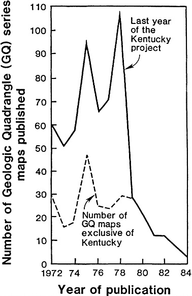
FIGURE 1 Number of square miles mapped by geologists during each of the past five decades. Only maps at scales of 1 mile to the inch or larger are included. From USGS Circular 1020.
be an increasing need for geologic maps to respond to problems of mineral resources, water availability, pollution, construction siting, utility routing, waste disposal, material storage, and others. If this is true, then there is reason to be concerned that apparently the geologic mapping effort/capability of the USGS is not keeping pace with the national need for geologic maps. The COGEOMAP
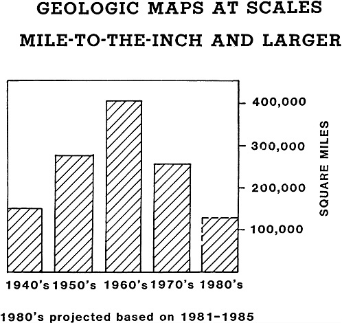
FIGURE 2 Number of Geologic Quadrangle (GQ) maps published between 1972 and 1984. From USGS Circular 1020.
program reflects a concern for this situation; namely, in an attempt to rectify the situation the USGS initiated a program to recruit the cooperation of state surveys. The level of state commitment and concern is not known, but on the basis of response to COGEOMAP, one gets the sense that states are placing more emphasis on geologic mapping than does the federal survey. It is apparent that more needs to be learned of the federal and state survey commitment to geologic mapping. If the roles of the USGS and state surveys are changing, emphasis is changing, or programs are expanding, it is important to determine what impact these shifts will have on any long-term national program of geologic mapping.


