
1
Implications of the NPOESS Nunn-McCurdy Certification and the Descoping of GOES-R
Since the 1960s, the United States has operated two separate operational polar-orbiting meteorological satellite systems: the Polar-orbiting Operational Environmental Satellite (POES) series managed by NOAA, and the Defense Meteorological Satellite Program (DMSP) managed by the Air Force.1 These satellites obtain environmental data that are processed to provide graphical weather images and specialized weather products. These satellite data are also the predominant input to numerical weather prediction models, which are a primary tool for forecasting weather 3 or more days in advance—including forecasting the path and intensity of hurricanes. The weather products and models are used to predict the potential impact of severe weather so that communities and emergency managers can help to prevent or mitigate its effects. Polar satellites also provide data used to monitor environmental phenomena, such as ozone depletion and drought conditions, as well as data sets that are used by researchers for a variety of studies such as climate monitoring.
The history of the NPOESS program and events leading to its restructuring as part of the June 2006 Nunn-McCurdy certification can be found in a recent report by the Government Accountability Office.2 In June 2006, the Department of Defense (with the agreement of both of its partner agencies, NOAA and NASA) certified a restructured NPOESS program, estimated to cost $12.5 billion through 2026. This decision approved a cost increase of $4 billion over the prior approved baseline cost and delayed the launch of the NPOESS Preparatory Project (NPP) mission and the first two NPOESS satellites. Current estimates have the launch of the NPP spacecraft slipping approximately 3 years to January 2010 and the launch of the first and second spacecraft in the NPOESS series, C1 and C2, slipping approximately 3 years to January 2013 and January 2016, respectively. The new program also reduced the number of satellites to be produced and launched from six to four, and reduced the number of instruments on the satellites from 13 to 9—consisting of 7 environmental sensors and 2 subsystems. The number of satellite orbits was also reduced from three to two, with the NPOESS satellite orbiting in the early morning and afternoon positions and the European MetOp satellites being relied on for midmorning orbit data. Figures 1.1 and 1.2 show NPOESS spacecraft, instruments, and orbits prior to and following the Nunn-McCurdy actions.3
|
1 |
Note that acronyms not defined in the text, especially those denoting individual instruments and missions, are defined in Appendix D. |
|
2 |
United States Government Accountability Office, Polar-orbiting Operational Environmental Satellites: Restructuring Is Under Way, but Challenges and Risks Remain, GAO-07-910T, U.S. Government Printing Office, Washington, D.C., 2007. Available at http://www.gao.gov/cgi-bin/getrpt?GAO-07-910T. |
|
3 |
NOAA-NASA, “Impacts of NPOESS Nunn-McCurdy Certification on Joint NASA-NOAA Climate Goals,” draft white paper, January 8, 2007. |
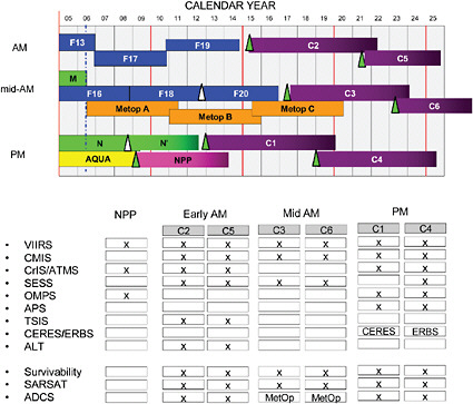
FIGURE 1.1 NPP and NPOESS program summary prior to the June 2006 Nunn-McCurdy program review and revisions. With the exception of CrIS, ATMS, and SESS, all key operational instruments, including SARSAT and ADCS, were intended to be flown on all three orbits. Climate and research-oriented sensors were generally designated a spot on a single satellite at any one time. The overall NPOESS constellation was designed as a stand-alone system, with the European series of MetOp satellite viewed as a separate, independent, complementary system. SOURCE: Courtesy of NOAA.
The Nunn-McCurdy process placed priority on continuity of operational weather measurements. Box 1.1 summarizes the effects of the Nunn-McCurdy action on previous objectives related to climate research.
HES CANCELLATION AND GOES-R
With the final two GOES satellites in the current GOES-N series completed, NOAA is now in the early stages of the acquisition process for the next generation of GOES satellites, called GOES-R. Late in 2006, NOAA announced the cancellation of plans to include the Hyperspectral Environmental Suite (HES)4 on GOES-R. At
|
4 |
For a description of HES, see T.J. Schmit, J. Li, and J. Gurka, “Introduction of the Hyperspectral Environmental Suite (HES) on GOES-R and Beyond,” presented at the International (A)TOVS Science Conference (ITSC-13) in Sainte Adele, Quebec, Canada, October 18-November 4, 2003, available at http://cimss.ssec.wisc.edu/itwg/itsc/itsc13/proceedings/session10/10_9_schmit.pdf. |
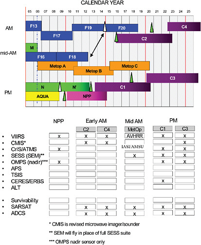
FIGURE 1.2 NPP and NPOESS program summary following the Nunn-McCurdy program review and revisions (status as of October 2006). The midmorning satellite coverage will be provided by the European MetOp satellite series, with descoped NPOESS satellites covering the early morning and afternoon orbits. Instruments removed from the core NPOESS program plan can be integrated and flown if outside funding will support the remaining development costs, as well as the cost of the instrument and its support. The canceled Conical Microwave Imager and Sounder sensor will be replaced by a sensor now called the Microwave Imager and Sounder (MIS). Although its specifications are not yet known, by design MIS will be a less expensive instrument with less developmental risk. SOURCE: Courtesy of NOAA.
|
BOX 1.1 Summary of Effects of Nunn-McCurdy NPOESS Certification
SOURCE: Adapted from J. Privette, J. Bates, and T. Karl, “Climate Goal Impacts and Possible Mitigations with a Certified NPOESS,” presentation at Polar Max 2006, available at http://www.npoess.noaa.gov/polarmax/2006/day03/4.5Privette_revised_NPOESS.Climate.POLARMAX.ppt. |
a September 2006 hearing of the U.S. House of Representatives Committee on Science and Technology, NOAA Administrator Conrad C. Lautenbacher explained:5
At first, we envisioned GOES-R as a satellite series that would contain significant technological advancements…. The Hyperspectral Environmental Suite (HES) was conceived as an advanced sounder and coastal water imager that would provide a profile of atmospheric temperature and moisture content used in weather forecasting and take images of coastal areas for water quality monitoring and coastal hazard assessment…. While HES potentially could have provided a major improvement in our ability to characterize the atmosphere and the coastal environment, we did not think it was prudent to accept that much risk in an operational satellite for an acquisition program. We are examining alternate ways to maintain today’s sounding capability for GOES-R…. Fulfilling the coastal waters component of the sounder capability remains a NOAA priority.
Although most of the June 2007 workshop focused on recovery options for the demanifested and descoped climate sensors on NPOESS, sessions were also held to discuss recovery options for HES, including a potential role for the GIFTS instrument.6
|
5 |
Written testimony of Vice Admiral Conrad C. Lautenbacher, Jr. (U.S. Navy, Ret.), Under Secretary of Commerce for Oceans and Atmosphere and NOAA Administrator, Oversight Hearing on the Government Accountability Office Report on NOAA’s Weather Satellite Program Before the Committee on Science, U.S. House of Representatives, September 29, 2006, available at http://www.legislative.noaa.gov/Testimony/lautenbacher092906.pdf. |
|
6 |
Developed under NASA’s New Millennium Program, the Geosynchronous Imaging Fourier Transform Spectrometer (GIFTS) was designed to obtain 80,000 closely spaced (horizontal ~4 kilometer), high-vertical-resolution (~1-2 kilometer) atmospheric temperature and water vapor profiles, every minute, from geostationary orbit. GIFTS was intended to serve as a major element in risk reduction plans for GOES-R. Because of |
THE NASA-NOAA STUDY
Shortly after the June 2006 announcement of the certified NPOESS program, the White House Office of Science and Technology Policy requested that NASA and NOAA study the climate science impacts attributable to the instrument deletions and scope reductions. Presentations by agency officials at the panel’s June 2007 workshop were effectively the starting point for many of the workshop’s discussions.7 In particular, “Mitigation Approaches to Address Impacts of NPOESS Nunn-McCurdy Certification on Joint NASA-NOAA Climate Goals,” reproduced as Appendix C, provided essential background information.
|
budgetary considerations, resulting partly from the Navy’s withdrawal of support for a spacecraft and launch vehicle, NASA discontinued funding for GIFTS beyond FY 2005. See W.L. Smith et al., “The Geosynchronous Imaging Fourier Transform Spectrometer (GIFTS),” pp. 700-707 in Proceedings of the 11th Conference on Satellite Meteorology and Oceanography, Madison, Wisc., October 15-18, 2001 (preprints), Call Number Reprint # 2999, American Meteorological Society, Boston, Mass., 2001, available at http://ams.confex.com/ams/pdfpapers/71904.pdf. |
|
7 |
All presentations, as well as summaries of the workshop sessions, are available at http://www7.nationalacademies.org/ssb/SSB_NPOESS2007_Presentations.html. |


